
LOGIN

Most Cited
- Green synthesis of iron oxide (Fe3O4) nanoparticles using two selected brown seaweeds: Characterization and application for lead bioremediation
- A nowcasting model for the prediction of typhoon tracks based on a long short term memory neural network
- The first Sentinel-1 SAR image of a typhoon
- Effect of temperature, salinity and irradiance on growth and photosynthesis of Ulva prolifera
- Sediment discharge of the Yellow River, China: past, present and future-A synthesis
Articles in press have been peer-reviewed and accepted, which are not yet assigned to volumes /issues, but are citable by Digital Object Identifier (DOI).
Display Method:
, Available online ,
doi: 10.1007/s13131-024-2350-7
Abstract:
Typhoons in the Western Pacific have a significant impact on the transport of heat, salt and particles through the Luzon Strait. However, there are very limited field observations of this impact because of extreme difficulties and even dangers for ship-based measurements during the rough weather. Here, we present the preliminary results from analyzing a dataset collected by a glider deployed west of the Luzon Strait a few days prior to the arrival of typhoon “MITAG”. The gilder data revealed an abnormally salinity (>34.8 psu) subsurface water apparently sourced from Kuroshio intrusion during the typhoon. When typhoon “MITAG” traveled on the east of the Luzon Strait, the positive wind stress curl strengthened the cyclonic eddy and weakened the anti-cyclonic eddy. This led to a slowdown of Kuroshio and made its intrusion easier. The main axis of the Kuroshio at the northern part of the strait shifted westward after the typhoon and did not return to its original position until a week later. The Ekman transport from persistent northerly wind of typhoon “MITAG” was significant, but its importance in enhancing the Kuroshio intrusion is only secondary relative to the eddies variations.
Typhoons in the Western Pacific have a significant impact on the transport of heat, salt and particles through the Luzon Strait. However, there are very limited field observations of this impact because of extreme difficulties and even dangers for ship-based measurements during the rough weather. Here, we present the preliminary results from analyzing a dataset collected by a glider deployed west of the Luzon Strait a few days prior to the arrival of typhoon “MITAG”. The gilder data revealed an abnormally salinity (>34.8 psu) subsurface water apparently sourced from Kuroshio intrusion during the typhoon. When typhoon “MITAG” traveled on the east of the Luzon Strait, the positive wind stress curl strengthened the cyclonic eddy and weakened the anti-cyclonic eddy. This led to a slowdown of Kuroshio and made its intrusion easier. The main axis of the Kuroshio at the northern part of the strait shifted westward after the typhoon and did not return to its original position until a week later. The Ekman transport from persistent northerly wind of typhoon “MITAG” was significant, but its importance in enhancing the Kuroshio intrusion is only secondary relative to the eddies variations.


, Available online ,
doi: 10.1007/s13131-024-2351-6
Abstract:
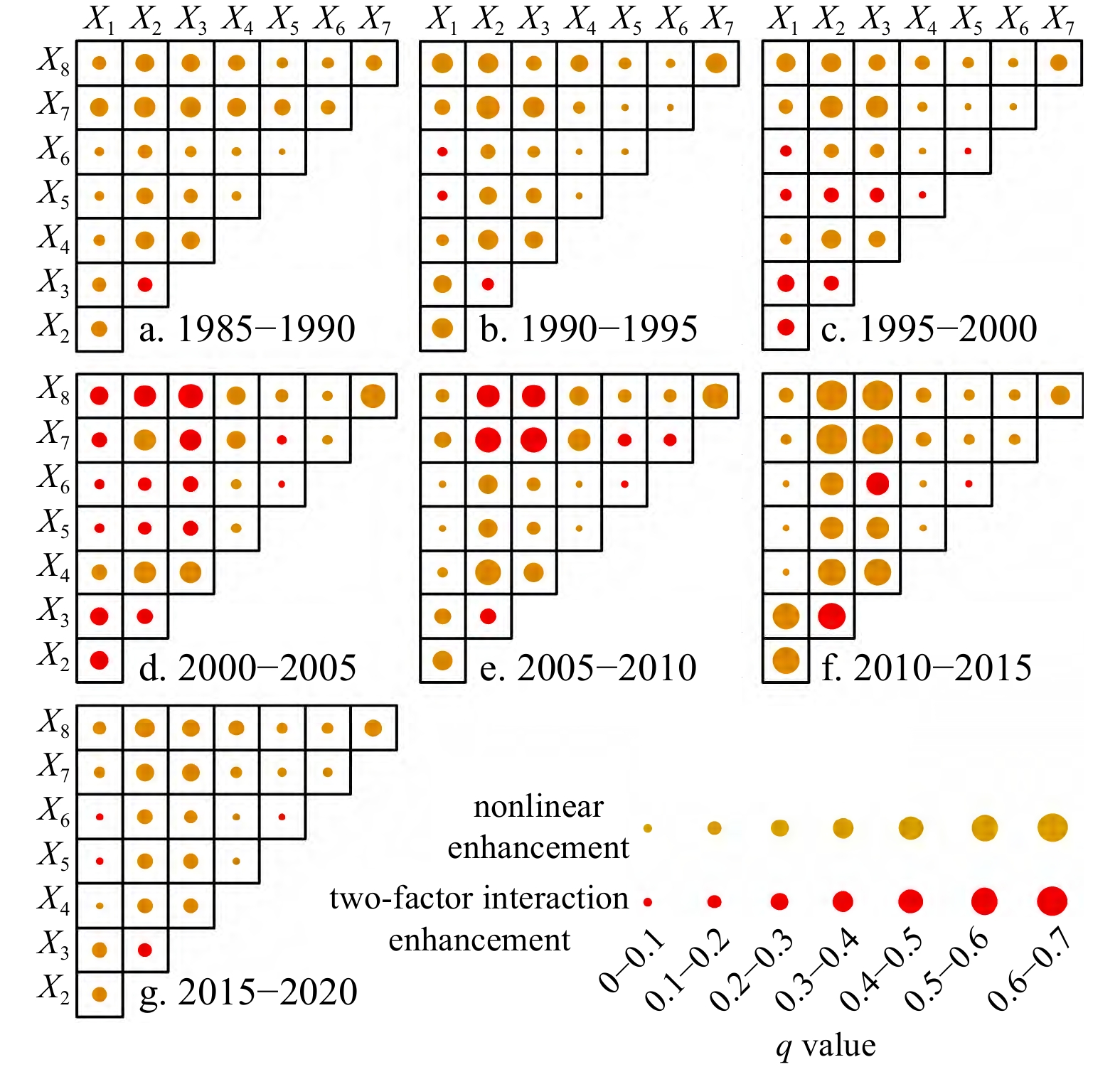
The long-term dynamic evolution and underlying mechanisms of coastal landscape pattern stability, driven by strong anthropogenic interference and consequently climate change, are topics of major interest in national and international scientific research. Guangdong Province, located in southeastern China, has been undergoing rapid urbanization over several decades. In this study, we quantitatively determined the scale threshold characteristics of coastal landscape pattern stability in Guangdong Province, from the dual perspective of spatial heterogeneity and spatial autocorrelation. An analysis of the spatiotemporal evolution of the coastal landscape was conducted after the optical scale was determined. Then, we applied the geodetector statistical method to quantitatively explore the mechanisms underlying coastal landscape pattern stability. Based on the inflection point of landscape metrics and the maximum value of the Moran I index, the optimal scale for analyzing coastal landscape pattern stability in Guangdong Province was 240 m × 240 m. Within the past several decades, coastal landscape pattern stability increased slightly and then decreased, with a turning point around 2005. The most significant variations in coastal landscape pattern stability were observed in the transition zone of rural-urban expansion. A q-statistics analysis showed that the explanatory power of paired factors was greater than that of a single driving factor; the paired factors with the greatest impact on coastal landscape pattern stability in Guangdong Province were the change in gross industrial output and change in average annual precipitation from 2010 to 2015, based on a q value of 0.604. These results will contribute to future efforts to achieve sustainable coastal development and provide a scientific basis and technical support for the rational planning and utilization of resources in large estuarine areas, including marine disaster prevention and seawall ecological restoration.
The long-term dynamic evolution and underlying mechanisms of coastal landscape pattern stability, driven by strong anthropogenic interference and consequently climate change, are topics of major interest in national and international scientific research. Guangdong Province, located in southeastern China, has been undergoing rapid urbanization over several decades. In this study, we quantitatively determined the scale threshold characteristics of coastal landscape pattern stability in Guangdong Province, from the dual perspective of spatial heterogeneity and spatial autocorrelation. An analysis of the spatiotemporal evolution of the coastal landscape was conducted after the optical scale was determined. Then, we applied the geodetector statistical method to quantitatively explore the mechanisms underlying coastal landscape pattern stability. Based on the inflection point of landscape metrics and the maximum value of the Moran I index, the optimal scale for analyzing coastal landscape pattern stability in Guangdong Province was 240 m × 240 m. Within the past several decades, coastal landscape pattern stability increased slightly and then decreased, with a turning point around 2005. The most significant variations in coastal landscape pattern stability were observed in the transition zone of rural-urban expansion. A q-statistics analysis showed that the explanatory power of paired factors was greater than that of a single driving factor; the paired factors with the greatest impact on coastal landscape pattern stability in Guangdong Province were the change in gross industrial output and change in average annual precipitation from 2010 to 2015, based on a q value of 0.604. These results will contribute to future efforts to achieve sustainable coastal development and provide a scientific basis and technical support for the rational planning and utilization of resources in large estuarine areas, including marine disaster prevention and seawall ecological restoration.


, Available online ,
doi: 10.1007/s13131-024-2377-9
Abstract:
Zhanjiang Bay is a major aquaculture area in China with many types of mariculture products (such as oysters, fish, and shrimp). The culture area and shrimp output in Zhanjiang Bay are ranked first in China. We investigated the total organic carbon (TOC), total nitrogen (TN), TOC/TN ratio, and stable isotopes (δ13C and δ15N) of the fish and shrimp feed, fish and shrimp feces, and sedimentary organic matter (SOM) in and around different aquaculture areas of northeastern Zhanjiang Bay to study the impact of aquaculture activities on SOM. The average TOC contents of fish and shrimp feed were 39.20% ± 0.91% and 39.29% ± 0.21%, respectively. The average TOC content in the surface sediments of the oyster culture area, the mixed (fish and shrimp) culture area, and the cage fish farm area were 0.66%, 0.88% ± 0.10%, and 0.58% ± 0.19%, respectively, which may indicate that mixed culture had a greater impact on SOM. The relatively high TOC and TN contents and relatively low TOC/TN ratios, and δ15N values in the upper layer of the core sediment in the mixed culture area could also support the significant influence of mixed culture. The average δ13C and δ15N values of fish and shrimp feed were −20.6‰ ± 2.2‰ and 1.8‰ ± 1.2‰, respectively, which were different from the isotopic values of SOM in the study area. δ13C and δ15N values for SOM in different aquaculture areas were different from those of nearby reference stations, probably reflecting the influence of aquaculture. The δ13C and δ15N values in the oyster culture area (−25.9‰ and 6.0‰, respectively) seemed to have reduced δ13C and enriched δ15N relative to those of the reference station (−24.6‰ and 5.8‰, respectively). This may reflect the influence of organic matter on oyster culture. The δ15N value of the station in the mixed culture area (7.1‰ ± 0.4‰) seemed to be relatively enriched in δ15N relative to that of the reference station (6.6‰). Sedimentation and the subsequent degradation of organic matter from mixed cultures may have contributed to this phenomenon. The surface sediment at the cage fish farm area seemed to be affected by fish feces and primary production based on the indication of δ13C and δ15N values. The sediment core at the mixed culture region (NS6) had lower TOC/TN ratios and more positive δ13C and δ15N values than the sediment core at the oyster culture area, suggesting a higher proportionate contribution of marine organic matter in the mixed culture area. In summary, oyster culture, mixed culture, and cage fish culture in northeastern Zhanjiang Bay had a certain degree of impact on SOM, and mixed culture had more significant influences on SOM based on the high TOC contents and the significant vertical variations of TOC/TN ratio and δ15N value in the sediment of this area. This study provides new insights into the impact of aquaculture activities on SOM content.
Zhanjiang Bay is a major aquaculture area in China with many types of mariculture products (such as oysters, fish, and shrimp). The culture area and shrimp output in Zhanjiang Bay are ranked first in China. We investigated the total organic carbon (TOC), total nitrogen (TN), TOC/TN ratio, and stable isotopes (δ13C and δ15N) of the fish and shrimp feed, fish and shrimp feces, and sedimentary organic matter (SOM) in and around different aquaculture areas of northeastern Zhanjiang Bay to study the impact of aquaculture activities on SOM. The average TOC contents of fish and shrimp feed were 39.20% ± 0.91% and 39.29% ± 0.21%, respectively. The average TOC content in the surface sediments of the oyster culture area, the mixed (fish and shrimp) culture area, and the cage fish farm area were 0.66%, 0.88% ± 0.10%, and 0.58% ± 0.19%, respectively, which may indicate that mixed culture had a greater impact on SOM. The relatively high TOC and TN contents and relatively low TOC/TN ratios, and δ15N values in the upper layer of the core sediment in the mixed culture area could also support the significant influence of mixed culture. The average δ13C and δ15N values of fish and shrimp feed were −20.6‰ ± 2.2‰ and 1.8‰ ± 1.2‰, respectively, which were different from the isotopic values of SOM in the study area. δ13C and δ15N values for SOM in different aquaculture areas were different from those of nearby reference stations, probably reflecting the influence of aquaculture. The δ13C and δ15N values in the oyster culture area (−25.9‰ and 6.0‰, respectively) seemed to have reduced δ13C and enriched δ15N relative to those of the reference station (−24.6‰ and 5.8‰, respectively). This may reflect the influence of organic matter on oyster culture. The δ15N value of the station in the mixed culture area (7.1‰ ± 0.4‰) seemed to be relatively enriched in δ15N relative to that of the reference station (6.6‰). Sedimentation and the subsequent degradation of organic matter from mixed cultures may have contributed to this phenomenon. The surface sediment at the cage fish farm area seemed to be affected by fish feces and primary production based on the indication of δ13C and δ15N values. The sediment core at the mixed culture region (NS6) had lower TOC/TN ratios and more positive δ13C and δ15N values than the sediment core at the oyster culture area, suggesting a higher proportionate contribution of marine organic matter in the mixed culture area. In summary, oyster culture, mixed culture, and cage fish culture in northeastern Zhanjiang Bay had a certain degree of impact on SOM, and mixed culture had more significant influences on SOM based on the high TOC contents and the significant vertical variations of TOC/TN ratio and δ15N value in the sediment of this area. This study provides new insights into the impact of aquaculture activities on SOM content.


, Available online ,
doi: 10.1007/s13131-023-2283-6
Abstract:
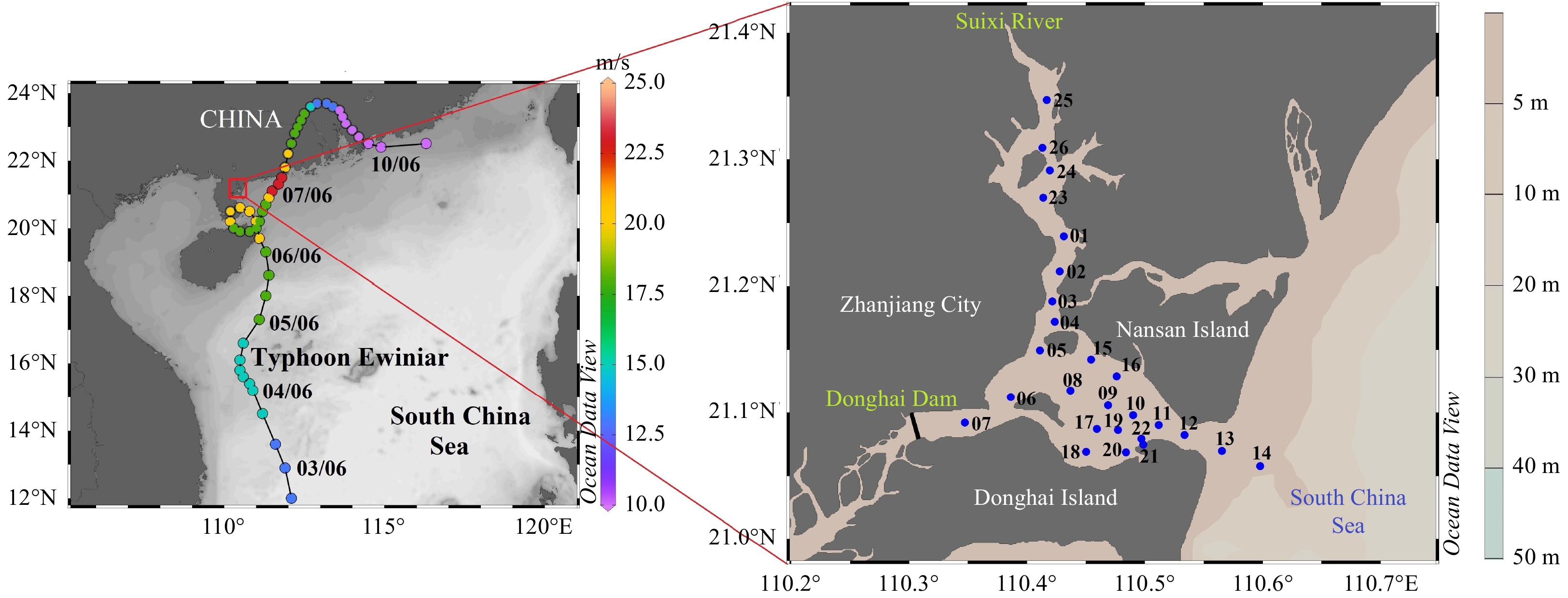
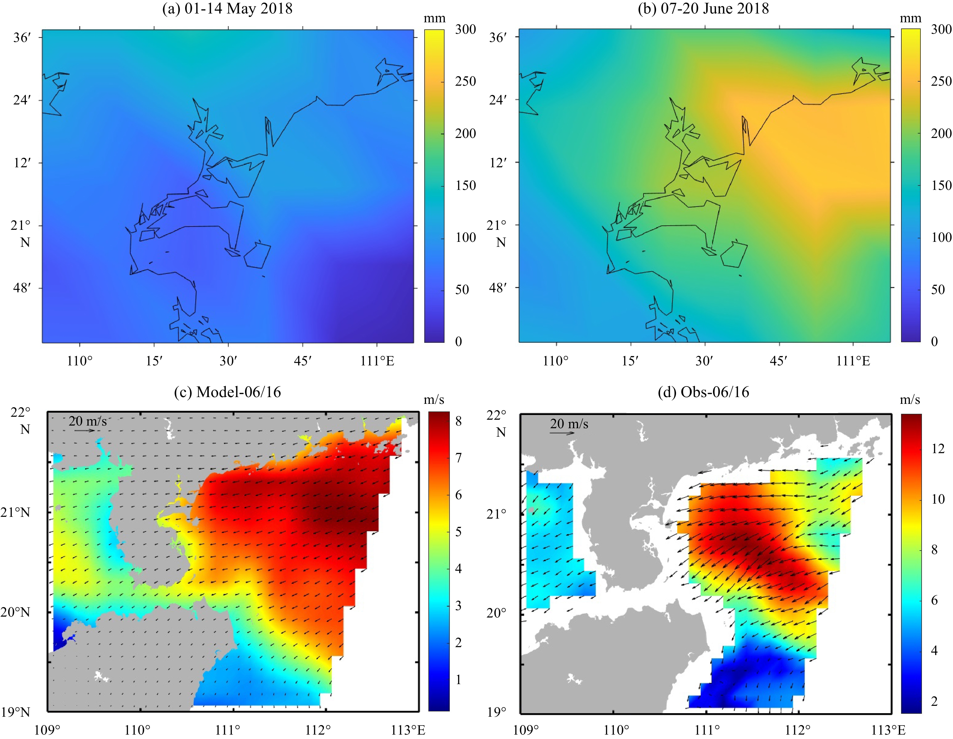
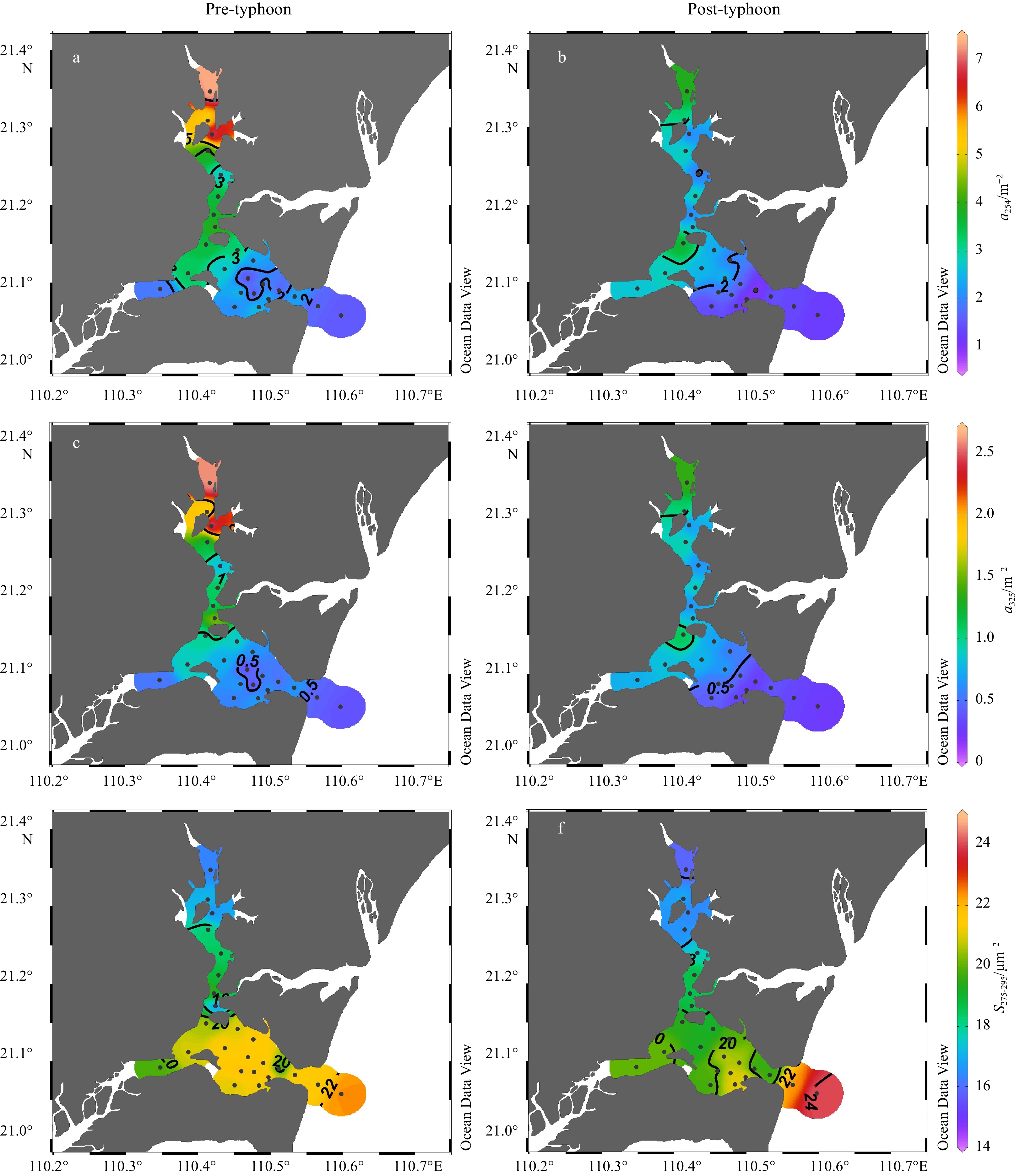
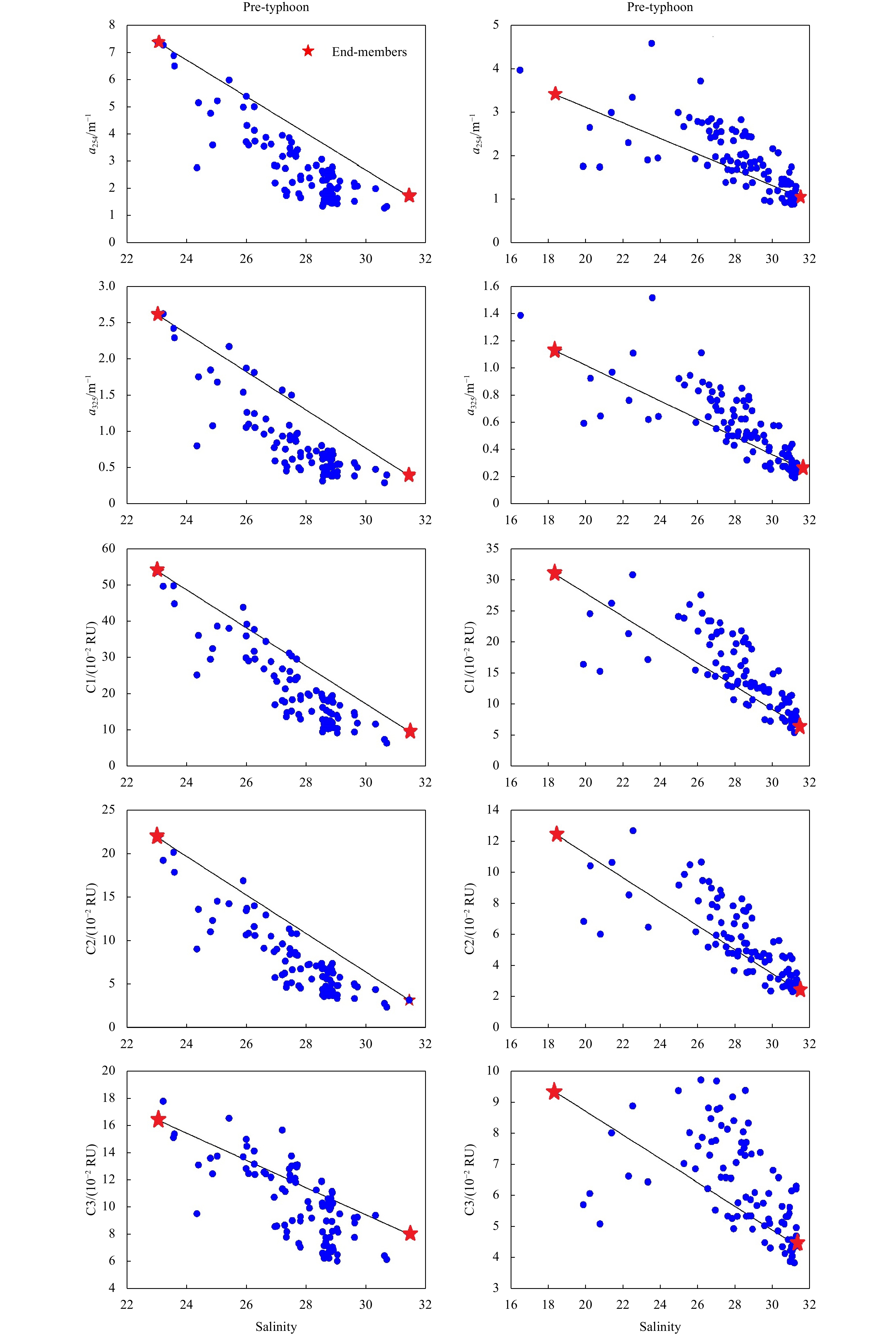
Highly productive estuaries facilitate intense decomposition of dissolved organic matter (DOM) as a carbon source. However, the specific impacts of typhoons on DOM decomposition in eutrophic bays remain unclear. To address this issue, we investigated the spectral characteristics of DOM before and after Typhoon Ewiniar in Zhanjiang Bay, a eutrophic semi-enclosed bay in the northwestern South China Sea. The results revealed that intense microbial decomposition of DOM occurred during the pre-typhoon period because high nutrient inputs facilitated the mobilization of DOM in the bay. However, the intrusion of external seawater induced by the typhoon diluted the nutrient levels in Zhanjiang Bay, reducing the impact of microbial decomposition on DOM during the post-typhoon period. Nevertheless, the net addition of DOM occurred in Zhanjiang Bay during the post-typhoon period, possibly because of the decomposition of particulate organic matter (POM) and desorption of particulate matter. In addition, an increase in apparent oxygen utilization, a decrease in DO saturation and the reduced level of Chl a indicated that organic matter (OM) decomposition was enhanced and OM decomposition shifted to POM decomposition in Zhanjiang Bay after the typhoon. Overall, our study highlighted the shift in the intense OM decomposition from DOM to POM decomposition before and after typhoons in eutrophic bays, providing new insights into the response of typhoons to biogeochemistry.
Highly productive estuaries facilitate intense decomposition of dissolved organic matter (DOM) as a carbon source. However, the specific impacts of typhoons on DOM decomposition in eutrophic bays remain unclear. To address this issue, we investigated the spectral characteristics of DOM before and after Typhoon Ewiniar in Zhanjiang Bay, a eutrophic semi-enclosed bay in the northwestern South China Sea. The results revealed that intense microbial decomposition of DOM occurred during the pre-typhoon period because high nutrient inputs facilitated the mobilization of DOM in the bay. However, the intrusion of external seawater induced by the typhoon diluted the nutrient levels in Zhanjiang Bay, reducing the impact of microbial decomposition on DOM during the post-typhoon period. Nevertheless, the net addition of DOM occurred in Zhanjiang Bay during the post-typhoon period, possibly because of the decomposition of particulate organic matter (POM) and desorption of particulate matter. In addition, an increase in apparent oxygen utilization, a decrease in DO saturation and the reduced level of Chl a indicated that organic matter (OM) decomposition was enhanced and OM decomposition shifted to POM decomposition in Zhanjiang Bay after the typhoon. Overall, our study highlighted the shift in the intense OM decomposition from DOM to POM decomposition before and after typhoons in eutrophic bays, providing new insights into the response of typhoons to biogeochemistry.


, Available online ,
doi: 10.1007/s13131-024-2372-1
Abstract:
The nutrients from the East China Sea (ECS) through the Tsushima/Korea Strait (TS) strongly impact the ecosystem of the Japan Sea (JS). The complex origins of the Tsushima Warm Current and the various nutrient sources in the ECS result in complex spatial-temporal variations in nutrients in the TS. Using a physical-biological model with a tracking technique, we studied the effects of nutrient sources from the ECS on the TS. Among all the nutrient sources, the Kuroshio has the highest nutrient concentrations in the TS. Its maximum concentration occurs at the bottom, while those of rivers and atmospheric deposition occur at the surface, and that of the Taiwan Strait occurs in the middle layer. The nutrient transport through the TS exhibits similar seasonal variations, as does the volume transport. The transport of nutrients from the Kuroshio accounts for more than 85% of the total. The transport of nutrients from the Taiwan Strait is greater during autumn and winter. The transport of dissolved inorganic nitrogen (DIN) from both rivers and atmospheric deposition through the TS peak in August. Nutrient transport cannot be equated with volume transport. The DIN in the less saline zone originates not only from rivers but also from atmospheric deposition and the Kuroshio. The transport of nutrients from the Taiwan Strait is not as significant as its volume transport in the TS.
The nutrients from the East China Sea (ECS) through the Tsushima/Korea Strait (TS) strongly impact the ecosystem of the Japan Sea (JS). The complex origins of the Tsushima Warm Current and the various nutrient sources in the ECS result in complex spatial-temporal variations in nutrients in the TS. Using a physical-biological model with a tracking technique, we studied the effects of nutrient sources from the ECS on the TS. Among all the nutrient sources, the Kuroshio has the highest nutrient concentrations in the TS. Its maximum concentration occurs at the bottom, while those of rivers and atmospheric deposition occur at the surface, and that of the Taiwan Strait occurs in the middle layer. The nutrient transport through the TS exhibits similar seasonal variations, as does the volume transport. The transport of nutrients from the Kuroshio accounts for more than 85% of the total. The transport of nutrients from the Taiwan Strait is greater during autumn and winter. The transport of dissolved inorganic nitrogen (DIN) from both rivers and atmospheric deposition through the TS peak in August. Nutrient transport cannot be equated with volume transport. The DIN in the less saline zone originates not only from rivers but also from atmospheric deposition and the Kuroshio. The transport of nutrients from the Taiwan Strait is not as significant as its volume transport in the TS.


, Available online
Abstract:
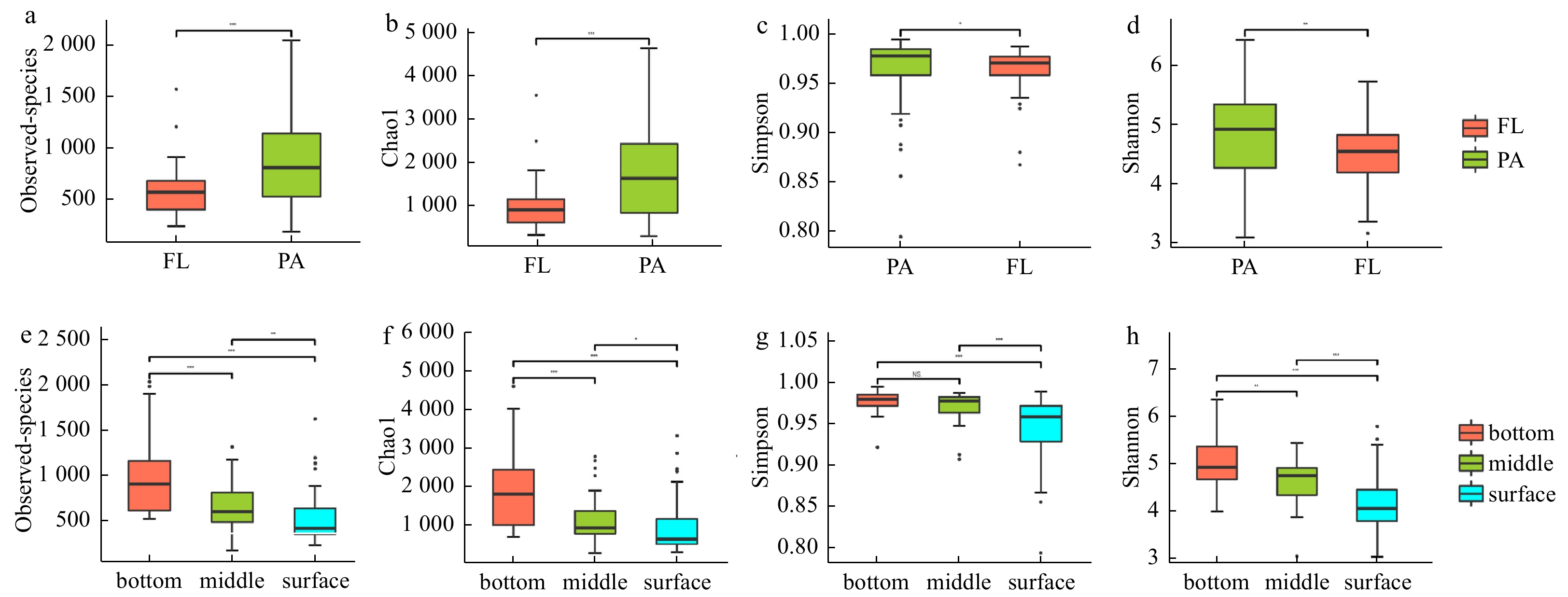
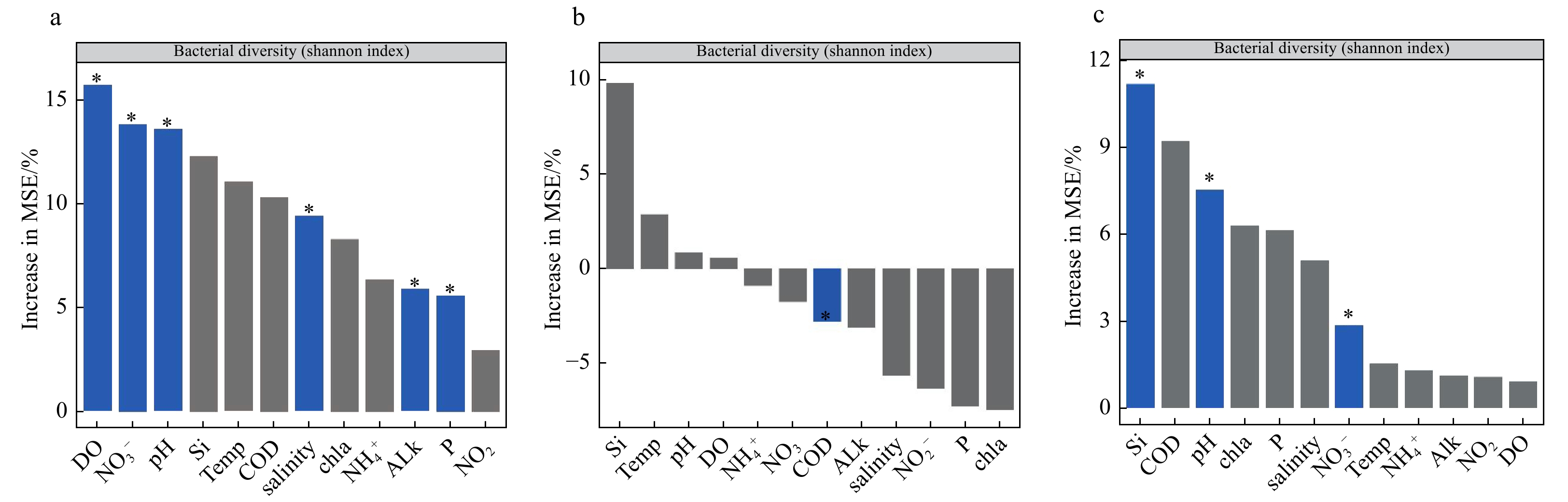
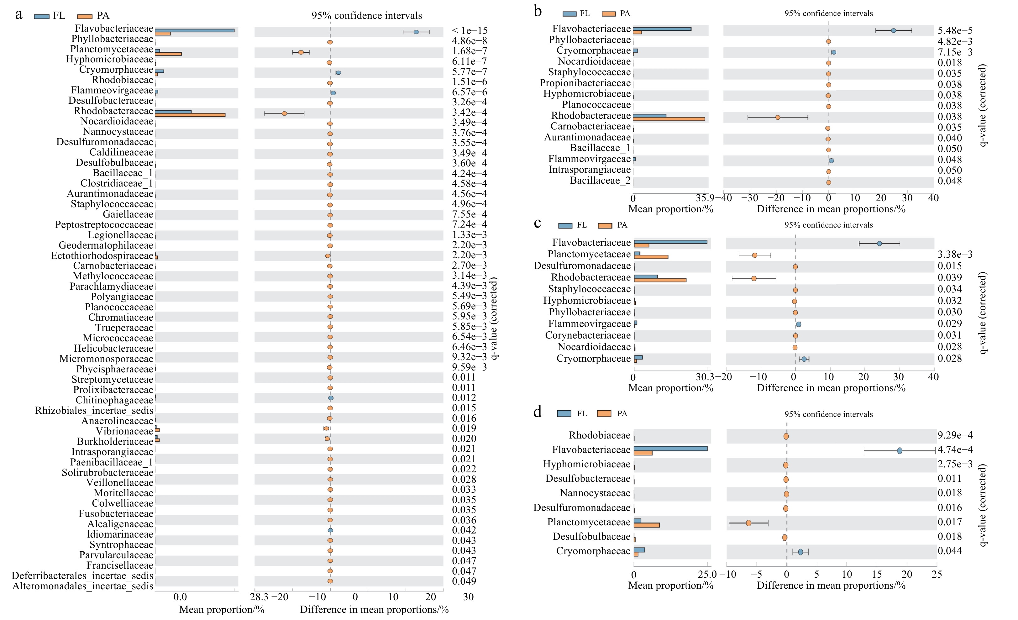
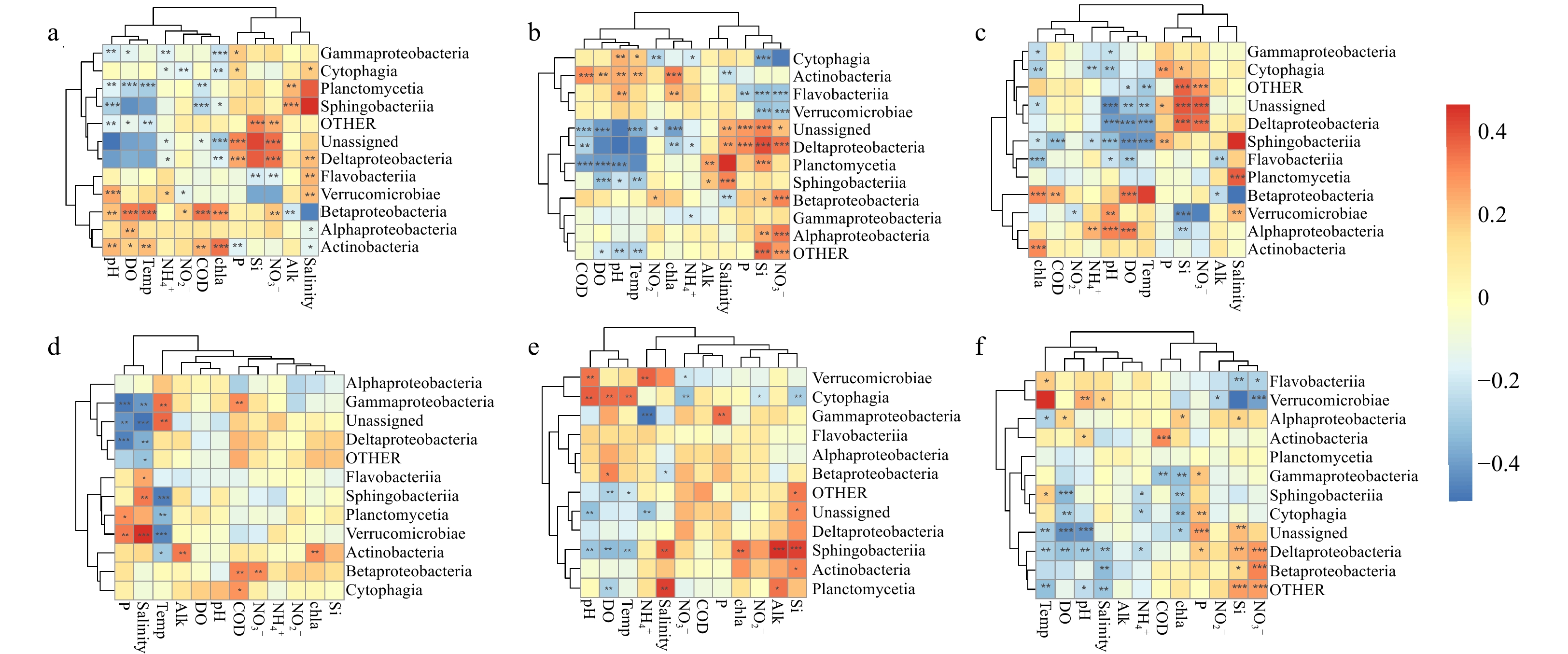
The Yangtze River Estuary (YRE) is a typical estuarine ecosystem, which plays an important role in the transport of terrestrial materials to the coastal ecosystem. With the change of global climate, the pH of the estuary would change correspondingly. However, the effect of pH on the bacterial community in YRE has rarely been investigated by using the culture-independent method. In this work, 16S rRNA amplicon sequencing was used to analyze the relationship between the environmental factors and bacterial community structures in the YRE. A total of 115 seawater samples were collected, and the results showed that the community diversity of particle-associated bacteria was significantly higher than those of the free-living bacteria (p < 0.05). The microbial diversity was significantly higher in the bottom water than the middle and surface water (p < 0.05), and the alpha-Proteobacteria were the most abundant microbial in the samples. In addition, among the collected environmental factors, pH has the greatest impact on microbial communities (p<0.001). Furthermore, the relative abundances of the microbial communities, including Verrucomicrobiae, gamma-Proteobacteria, Planctomycetia, beta-Proteobacteria, Actinobacteria, Sphingobacteriia, delta-Proteobacteria, and Cytophagia, could be significantly influenced by pH (p < 0.001). Overall, these findings reveal the extent of the influence of pH on different communities and expand our understanding of the effect of ocean acidification on the microbial communities in YRE.
The Yangtze River Estuary (YRE) is a typical estuarine ecosystem, which plays an important role in the transport of terrestrial materials to the coastal ecosystem. With the change of global climate, the pH of the estuary would change correspondingly. However, the effect of pH on the bacterial community in YRE has rarely been investigated by using the culture-independent method. In this work, 16S rRNA amplicon sequencing was used to analyze the relationship between the environmental factors and bacterial community structures in the YRE. A total of 115 seawater samples were collected, and the results showed that the community diversity of particle-associated bacteria was significantly higher than those of the free-living bacteria (p < 0.05). The microbial diversity was significantly higher in the bottom water than the middle and surface water (p < 0.05), and the alpha-Proteobacteria were the most abundant microbial in the samples. In addition, among the collected environmental factors, pH has the greatest impact on microbial communities (p<0.001). Furthermore, the relative abundances of the microbial communities, including Verrucomicrobiae, gamma-Proteobacteria, Planctomycetia, beta-Proteobacteria, Actinobacteria, Sphingobacteriia, delta-Proteobacteria, and Cytophagia, could be significantly influenced by pH (p < 0.001). Overall, these findings reveal the extent of the influence of pH on different communities and expand our understanding of the effect of ocean acidification on the microbial communities in YRE.


, Available online ,
doi: 10.1007/s13131-023-2308-9
Abstract:
Understanding the mechanism of harmful algal bloom formation is vital for effectively preventing algal bloom outbreaks in coastal environments. Karenia spp. blooms in the East China Sea show a significant correlation with nutrient regimes. However, the impact of key components of nutrients, especially dissolved organic nitrogen (DON), on the blooms of Karenia spp. is not clear. Quantitative research is still lacking. In this study, the cruise observations, field mesocosm-flask culture experiments, and a multinitrogen-tri-phytoplankton-detritus model (NTPD) are combined to reveal the quantitative influence of nutrient regimes on the shift of Prorocentrum donghaiense and Karenia spp. in the East China Sea. It has a synchronism rhythm of diatom-P. donghaiense-Karenia spp.-diatom loop in the field culture experiment, which is consistent with the results of the cruise observation. The results showed that the processes of Terrigenous DON (TeDON) and dissolved inorganic nitrogen (DIN:\begin{document}$\mathrm{NO}_{3}^{-} $\end{document} ![]()
![]()
\begin{document}$\mathrm{NH}_{4}^{+} $\end{document} ![]()
![]()
Understanding the mechanism of harmful algal bloom formation is vital for effectively preventing algal bloom outbreaks in coastal environments. Karenia spp. blooms in the East China Sea show a significant correlation with nutrient regimes. However, the impact of key components of nutrients, especially dissolved organic nitrogen (DON), on the blooms of Karenia spp. is not clear. Quantitative research is still lacking. In this study, the cruise observations, field mesocosm-flask culture experiments, and a multinitrogen-tri-phytoplankton-detritus model (NTPD) are combined to reveal the quantitative influence of nutrient regimes on the shift of Prorocentrum donghaiense and Karenia spp. in the East China Sea. It has a synchronism rhythm of diatom-P. donghaiense-Karenia spp.-diatom loop in the field culture experiment, which is consistent with the results of the cruise observation. The results showed that the processes of Terrigenous DON (TeDON) and dissolved inorganic nitrogen (DIN:


, Available online ,
doi: 10.1007/s13131-024-2302-2
Abstract:
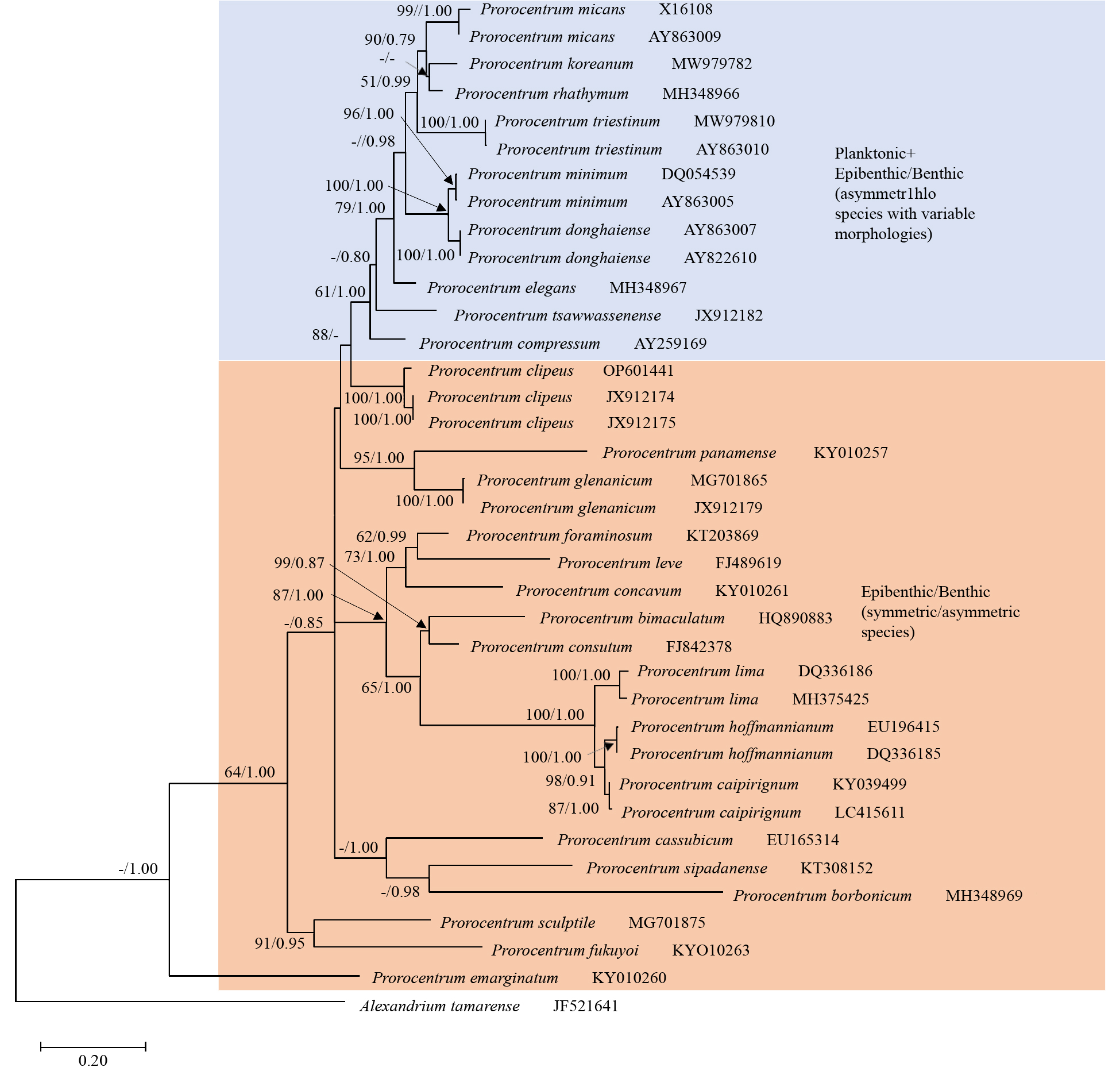
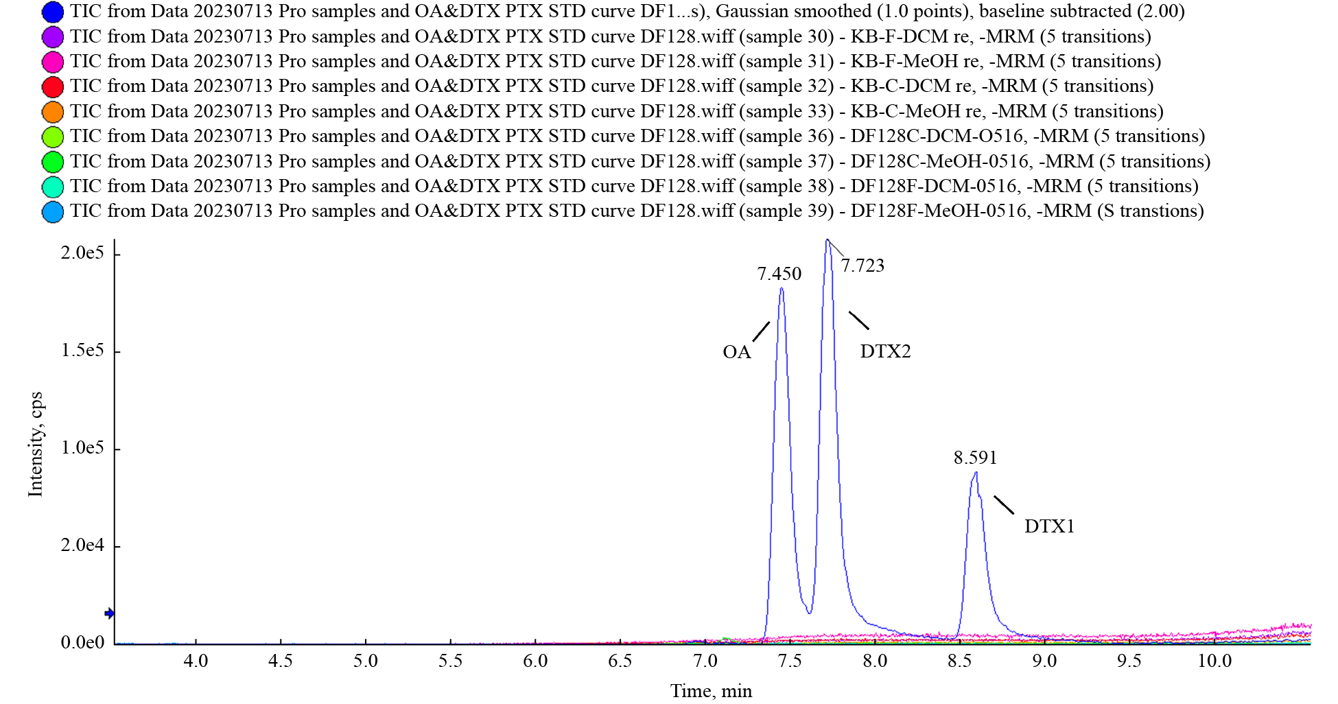
More than 30 species of benthic Prorocentrum have been identified, some of which produce okadaic acid (OA) and its derivatives, dinophysistoxins (DTXs), which cause diarrhetic shellfish poisoning (DSP). Increasing numbers of benthic Prorocentrum species have been reported in tropical and subtropical waters of the China Sea. In contrast, only a few benthic Prorocentrum species have been reported in temperate waters. In this study, morphological descriptions obtained using light microscopy, scanning electron microscopy and molecular characterization of one Prorocentrum clipeus strain isolated from the Yellow Sea of China are presented. Prorocentrum clipeus cells were nearly circular in shape, with a collar, ridge, and one protrusion. The periflagellar area was wide U-shaped, with two curved projections on platelet 1a. Nine periflagellar platelets of different sizes were observed. The morphology closely fits that of the species isolated from other locations. Phylogenetic analysis based on the molecular sequences of the small subunit (SSU) rDNA, internal transcribed spacer (ITS), and large subunit (LSU) rDNA was performed. A comprehensive metabolomic analysis incorporating target, suspect and non-target screenings was first applied to investigate the intracellular and extracellular metabolite profiles of the current isolate of P. clipeus. According to the results of the target and suspect screenings, 179 metabolites or toxins produced by DSP-related algal species, including OA, dinophysistoxin-1 (DTX1), dinophysistoxin-2 (DTX2) and pectenotoxin-2 (PTX2), were not detected. Non-target screening involving feature-based molecular networking (FBMN) provided a global view of major metabolites produced by the P. clipeus DF128 strain and revealed 23 clusters belonging to at least 13 compound classes, with organometallic compounds, lipids and lipid-like molecules, phenylpropanoids and polyketides, and benzenoids as major types. To date, this is the first record of the characterization of P. clipeus in samples from Chinese waters. Our results support the wide distribution of epibenthic Prorocentrum species.
More than 30 species of benthic Prorocentrum have been identified, some of which produce okadaic acid (OA) and its derivatives, dinophysistoxins (DTXs), which cause diarrhetic shellfish poisoning (DSP). Increasing numbers of benthic Prorocentrum species have been reported in tropical and subtropical waters of the China Sea. In contrast, only a few benthic Prorocentrum species have been reported in temperate waters. In this study, morphological descriptions obtained using light microscopy, scanning electron microscopy and molecular characterization of one Prorocentrum clipeus strain isolated from the Yellow Sea of China are presented. Prorocentrum clipeus cells were nearly circular in shape, with a collar, ridge, and one protrusion. The periflagellar area was wide U-shaped, with two curved projections on platelet 1a. Nine periflagellar platelets of different sizes were observed. The morphology closely fits that of the species isolated from other locations. Phylogenetic analysis based on the molecular sequences of the small subunit (SSU) rDNA, internal transcribed spacer (ITS), and large subunit (LSU) rDNA was performed. A comprehensive metabolomic analysis incorporating target, suspect and non-target screenings was first applied to investigate the intracellular and extracellular metabolite profiles of the current isolate of P. clipeus. According to the results of the target and suspect screenings, 179 metabolites or toxins produced by DSP-related algal species, including OA, dinophysistoxin-1 (DTX1), dinophysistoxin-2 (DTX2) and pectenotoxin-2 (PTX2), were not detected. Non-target screening involving feature-based molecular networking (FBMN) provided a global view of major metabolites produced by the P. clipeus DF128 strain and revealed 23 clusters belonging to at least 13 compound classes, with organometallic compounds, lipids and lipid-like molecules, phenylpropanoids and polyketides, and benzenoids as major types. To date, this is the first record of the characterization of P. clipeus in samples from Chinese waters. Our results support the wide distribution of epibenthic Prorocentrum species.


, Available online
Abstract:
Eutrophication caused by inputs of excess nitrogen (N) has become a serious environmental problem in Hangzhou Bay (China), but the sources of this nitrogen are not well understood. In this study, the August 2019 distributions of salinity, nutrients (nitrate\begin{document}${{\rm {NO}}_3^-} $\end{document} ![]()
![]()
\begin{document}${{\rm {NO}}_3^-} $\end{document} ![]()
![]()
\begin{document}${{\rm {NO}}_3^-} $\end{document} ![]()
![]()
Eutrophication caused by inputs of excess nitrogen (N) has become a serious environmental problem in Hangzhou Bay (China), but the sources of this nitrogen are not well understood. In this study, the August 2019 distributions of salinity, nutrients (nitrate


, Available online
Abstract:
Eutrophication in coastal waters has been increasing remarkably, severely impacting the water quality in mariculture bays. In this study, we conducted multiple isotopic measurements on suspended particulate nitrogen (δ15N-PN) and dissolved nitrate (δ15N-\begin{document}${\mathrm{NO}}_3^- $\end{document} ![]()
![]()
\begin{document}${\mathrm{NO}}_3^- $\end{document} ![]()
![]()
\begin{document}${\mathrm{NO}}_3^- $\end{document} ![]()
![]()
\begin{document}${\mathrm{NO}}_3^- $\end{document} ![]()
![]()
\begin{document}${\mathrm{NO}}_3^- $\end{document} ![]()
![]()
Eutrophication in coastal waters has been increasing remarkably, severely impacting the water quality in mariculture bays. In this study, we conducted multiple isotopic measurements on suspended particulate nitrogen (δ15N-PN) and dissolved nitrate (δ15N-


, Available online
Abstract:
Ocean fronts play important roles in nutrient transport and in the shaping ecological patterns. Frontal zones in small bays are typically small in scale, have a complex structure, and they are spatially and temporally variable, but there are limited data on how biological communities respond to this variation. Hangzhou Bay, a medium-sized estuary in China, is an ideal place in which to study the response of plankton to small-scale ocean fronts, because three water masses (Qiantang River Diluted Water, Changjiang River Diluted Water, and the East China Sea current) converge here and form dynamic salinity fronts throughout the year. We investigate zooplankton communities, and temperature, salinity and chlorophyll a (Chl a) in Hangzhou Bay in June (wet period) and December (dry period) of 2022 and examine the dominant environmental factors that affect zooplankton community spatial variability. We then match the spatial distributions of zooplankton communities with those of salinity fronts. Salinity is the most important explanatory variable to affect zooplankton community spatial variability during both wet and dry periods, in that it contributes >60% of the variability in community structure. Furthermore, the spatial distributions of zooplankton match well with salinity fronts. During December, with weaker Qiantang River Diluted Water and a stronger secondary Changjiang River Plume, zooplankton communities occur in moderate salinity (MS, salinity range 15.6 ± 2.2) and high salinity (HS, 22.4 ± 1.7) regions, and their ecological boundaries closely match the Qiantang River Diluted Water front. In June, different zooplankton communities occur in low salinity (LS, 3.9 ± 1.0), MS (11.7 ± 3.6) and HS (21.3 ± 1.9) regions. Although the LS region occurs abnormally in the central bay rather than its apex because of the anomalous influence of rising and falling tides during the sampling period, the ecological boundaries still match salinity interfaces. Low-salinity or brackish-water zooplankter taxa are relatively more abundant in LS or MS regions, and the biomass and abundance of zooplankton is higher in the MS region.
Ocean fronts play important roles in nutrient transport and in the shaping ecological patterns. Frontal zones in small bays are typically small in scale, have a complex structure, and they are spatially and temporally variable, but there are limited data on how biological communities respond to this variation. Hangzhou Bay, a medium-sized estuary in China, is an ideal place in which to study the response of plankton to small-scale ocean fronts, because three water masses (Qiantang River Diluted Water, Changjiang River Diluted Water, and the East China Sea current) converge here and form dynamic salinity fronts throughout the year. We investigate zooplankton communities, and temperature, salinity and chlorophyll a (Chl a) in Hangzhou Bay in June (wet period) and December (dry period) of 2022 and examine the dominant environmental factors that affect zooplankton community spatial variability. We then match the spatial distributions of zooplankton communities with those of salinity fronts. Salinity is the most important explanatory variable to affect zooplankton community spatial variability during both wet and dry periods, in that it contributes >60% of the variability in community structure. Furthermore, the spatial distributions of zooplankton match well with salinity fronts. During December, with weaker Qiantang River Diluted Water and a stronger secondary Changjiang River Plume, zooplankton communities occur in moderate salinity (MS, salinity range 15.6 ± 2.2) and high salinity (HS, 22.4 ± 1.7) regions, and their ecological boundaries closely match the Qiantang River Diluted Water front. In June, different zooplankton communities occur in low salinity (LS, 3.9 ± 1.0), MS (11.7 ± 3.6) and HS (21.3 ± 1.9) regions. Although the LS region occurs abnormally in the central bay rather than its apex because of the anomalous influence of rising and falling tides during the sampling period, the ecological boundaries still match salinity interfaces. Low-salinity or brackish-water zooplankter taxa are relatively more abundant in LS or MS regions, and the biomass and abundance of zooplankton is higher in the MS region.


, Available online ,
doi: 10.1007/s13131-024-2343-6
Abstract:
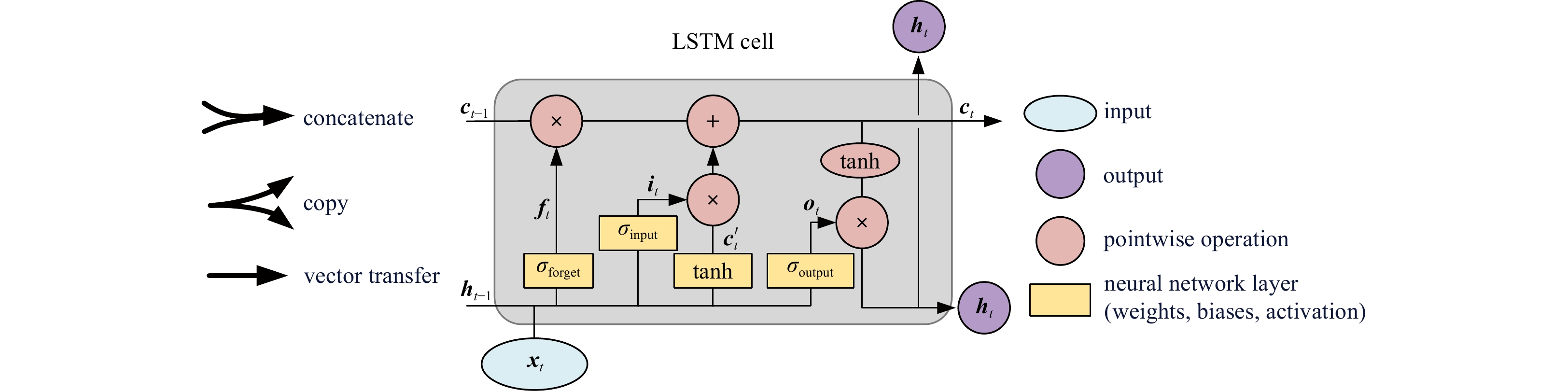
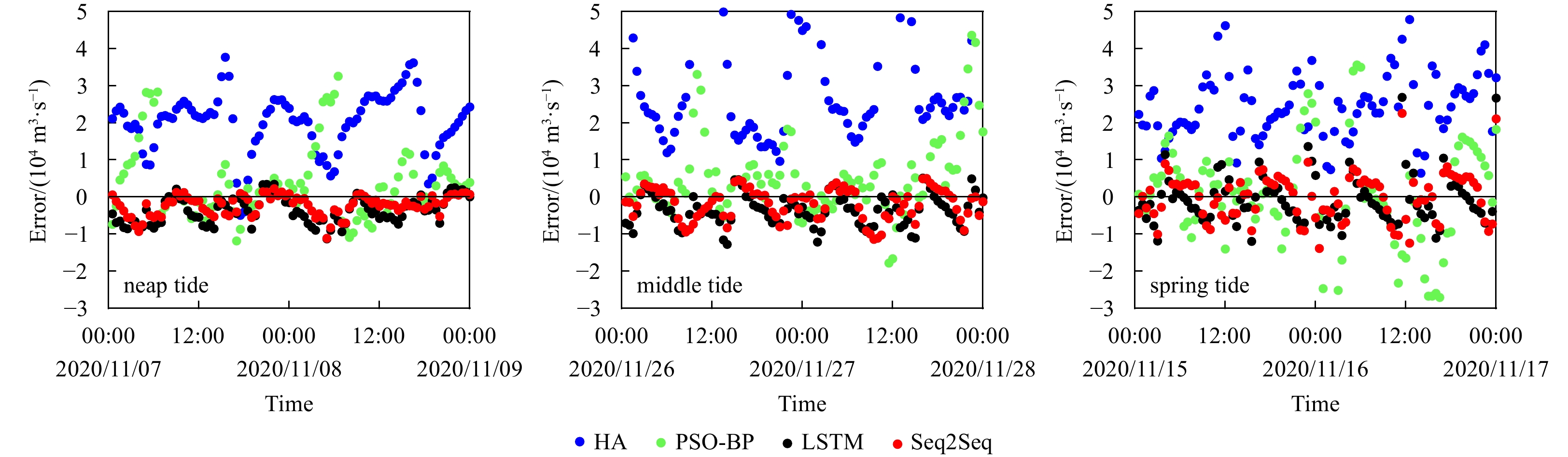
The complexity of river-tide interaction poses a significant challenge in predicting discharge in tidal rivers. Long short-term memory (LSTM) networks excel in processing and predicting crucial events with extended intervals and time delays in time series data. Additionally, the sequence-to-sequence (Seq2Seq) model, known for handling temporal relationships, adapting to variable-length sequences, effectively capturing historical information, and accommodating various influencing factors, emerges as a robust and flexible tool in discharge forecasting. In this study, we introduce the application of LSTM-based Seq2Seq models for the first time in forecasting the discharge of a tidal reach of the Changjiang River (Yangtze River) Estuary. This study focuses on discharge forecasting using three key input characteristics: flow velocity, water level, and discharge, which means the structure of multiple input and single output is adopted. The experiment used the discharge data of the whole year of 2020, of which the first 80% is used as the training set, and the last 20% is used as the test set. This means that the data covers different tidal cycles, which helps to test the forecasting effect of different models in different tidal cycles and different runoff. The experimental results indicate that the proposed models demonstrate advantages in long-term, mid-term, and short-term discharge forecasting. The Seq2Seq models improved by 6%–60% and 5%–20% of the relative standard deviation compared to the harmonic analysis models and improved back propagation neural network models in discharge prediction, respectively. In addition, the relative accuracy of the Seq2Seq model is 1% to 3% higher than that of the LSTM model. Analytical assessment of the prediction errors shows that the Seq2Seq models are insensitive to the forecast lead time and they can capture characteristic values such as maximum flood tide flow and maximum ebb tide flow in the tidal cycle well. This indicates the significance of the Seq2Seq models.
The complexity of river-tide interaction poses a significant challenge in predicting discharge in tidal rivers. Long short-term memory (LSTM) networks excel in processing and predicting crucial events with extended intervals and time delays in time series data. Additionally, the sequence-to-sequence (Seq2Seq) model, known for handling temporal relationships, adapting to variable-length sequences, effectively capturing historical information, and accommodating various influencing factors, emerges as a robust and flexible tool in discharge forecasting. In this study, we introduce the application of LSTM-based Seq2Seq models for the first time in forecasting the discharge of a tidal reach of the Changjiang River (Yangtze River) Estuary. This study focuses on discharge forecasting using three key input characteristics: flow velocity, water level, and discharge, which means the structure of multiple input and single output is adopted. The experiment used the discharge data of the whole year of 2020, of which the first 80% is used as the training set, and the last 20% is used as the test set. This means that the data covers different tidal cycles, which helps to test the forecasting effect of different models in different tidal cycles and different runoff. The experimental results indicate that the proposed models demonstrate advantages in long-term, mid-term, and short-term discharge forecasting. The Seq2Seq models improved by 6%–60% and 5%–20% of the relative standard deviation compared to the harmonic analysis models and improved back propagation neural network models in discharge prediction, respectively. In addition, the relative accuracy of the Seq2Seq model is 1% to 3% higher than that of the LSTM model. Analytical assessment of the prediction errors shows that the Seq2Seq models are insensitive to the forecast lead time and they can capture characteristic values such as maximum flood tide flow and maximum ebb tide flow in the tidal cycle well. This indicates the significance of the Seq2Seq models.


, Available online ,
doi: 10.1007/s13131-023-2197-3
Abstract:
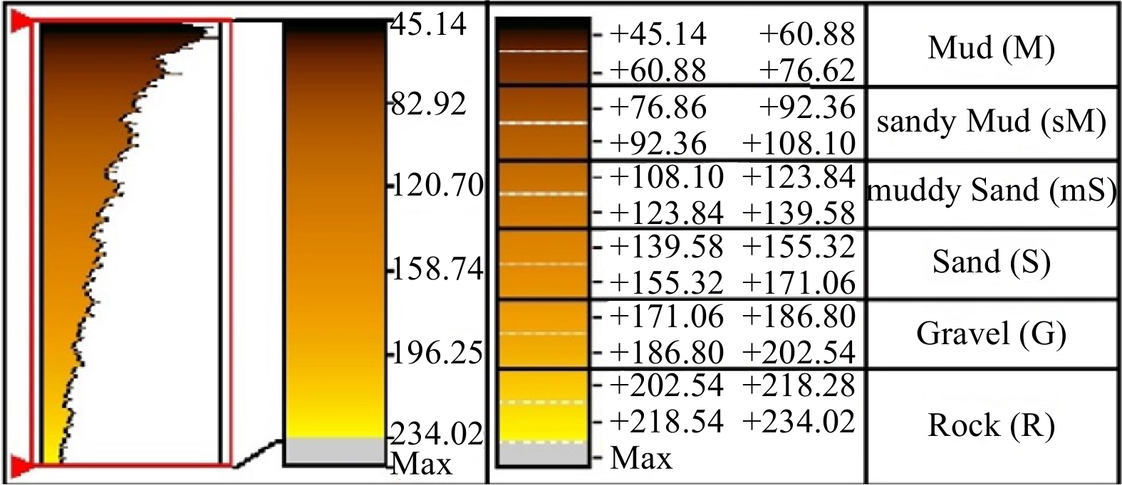
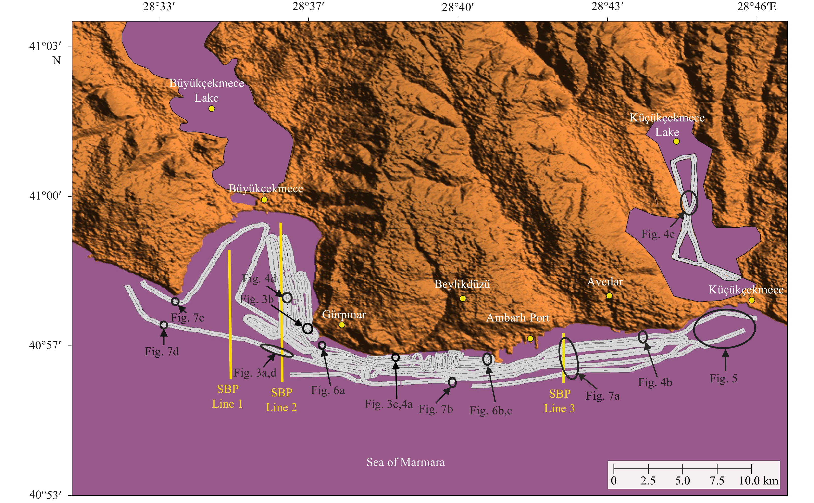
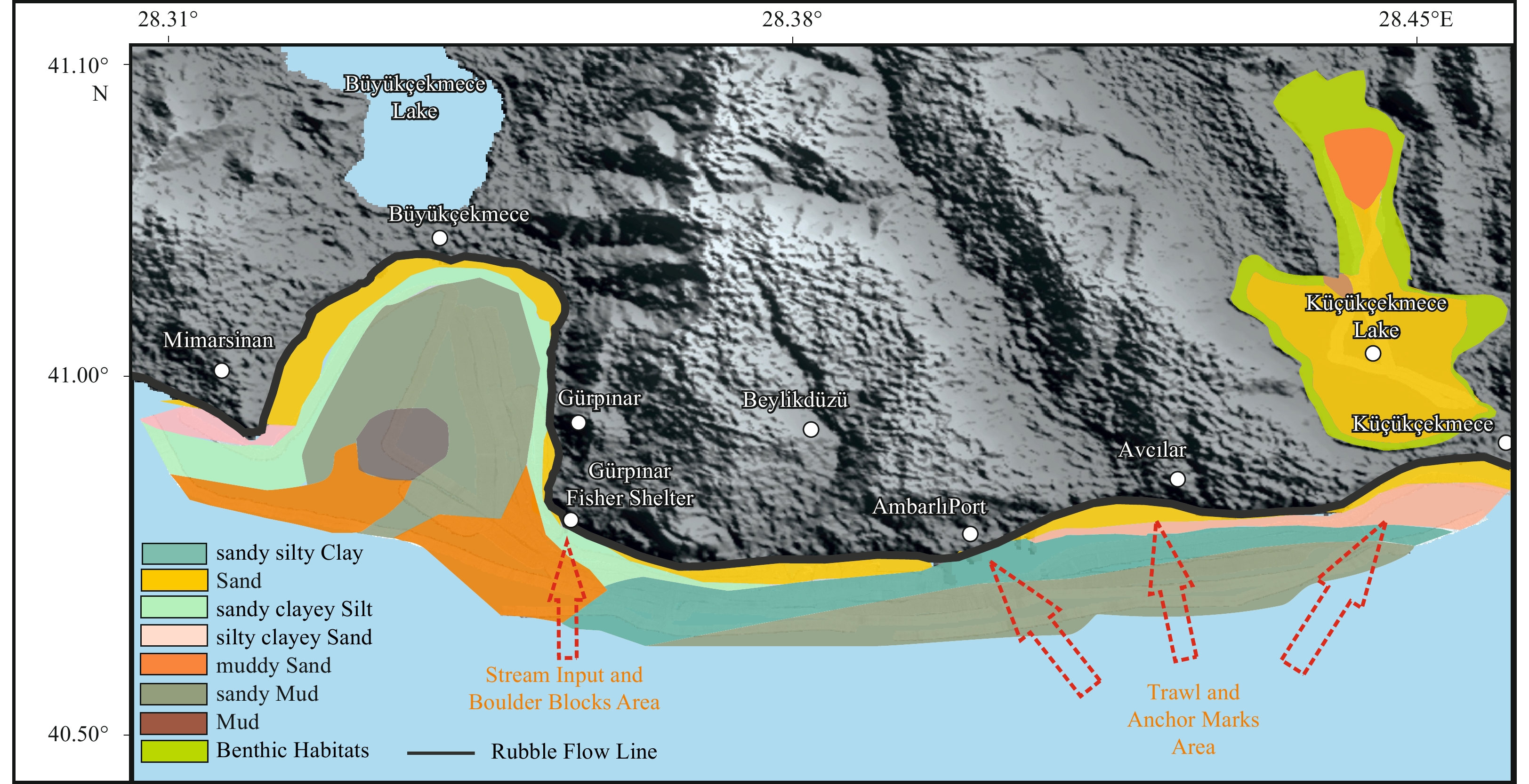
To protect the sustainability of the benefits from seas and near coastal areas, which have under the effect of the very complex hydrodynamic conditions and intensive human activities, without disrupting the balance of nature, it is necessary to image the status of the seafloor features. Therefore, this study presents the deformations, depositional conditions, underwater constructions, and the other non-natural impacts on the seafloor of the nearshore area at western Istanbul (between Küçükçekmece and Büyükçekmece lagoons) where it intensely used by the citizens. The results of the study may provide some guidance for understanding the impacts and risk factors of uses that are or will be conducted in coastal and/or near-coastal areas. Construction planning for civil coastal structures and areas should be done in great harmony with nature, minimizing negative environmental impacts. Although sediment distribution in the area is generally quite complex, the current state of the region, wave action, hydrodynamic conditions, the amount of material transported from the land, and bathymetry are important influencing factors. The seafloor has been damaged primarily by anchor deformation and associated bottom scanning, as well as disturbing trawl tracks. The seafloor was observed as partially shallowing near the constructions (such as natural gas pipelines, fishermen’s shelter, and port piles) of coastal areas and associated with sand deposits. Therefore, scanning the seafloor using side-scan sonar may provide valuable frequency data to prevent future disruptions.
To protect the sustainability of the benefits from seas and near coastal areas, which have under the effect of the very complex hydrodynamic conditions and intensive human activities, without disrupting the balance of nature, it is necessary to image the status of the seafloor features. Therefore, this study presents the deformations, depositional conditions, underwater constructions, and the other non-natural impacts on the seafloor of the nearshore area at western Istanbul (between Küçükçekmece and Büyükçekmece lagoons) where it intensely used by the citizens. The results of the study may provide some guidance for understanding the impacts and risk factors of uses that are or will be conducted in coastal and/or near-coastal areas. Construction planning for civil coastal structures and areas should be done in great harmony with nature, minimizing negative environmental impacts. Although sediment distribution in the area is generally quite complex, the current state of the region, wave action, hydrodynamic conditions, the amount of material transported from the land, and bathymetry are important influencing factors. The seafloor has been damaged primarily by anchor deformation and associated bottom scanning, as well as disturbing trawl tracks. The seafloor was observed as partially shallowing near the constructions (such as natural gas pipelines, fishermen’s shelter, and port piles) of coastal areas and associated with sand deposits. Therefore, scanning the seafloor using side-scan sonar may provide valuable frequency data to prevent future disruptions.


, Available online
Abstract:
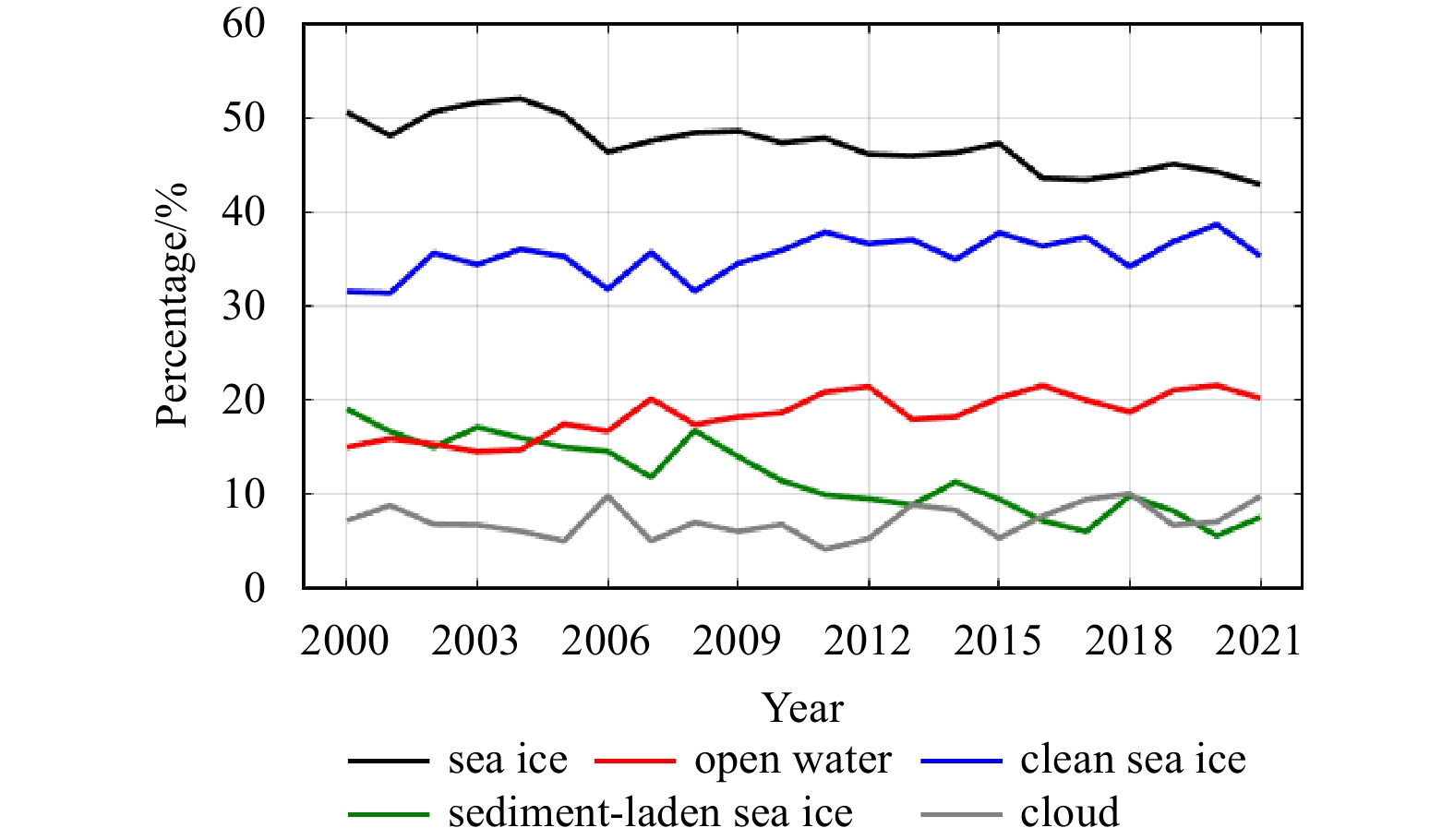
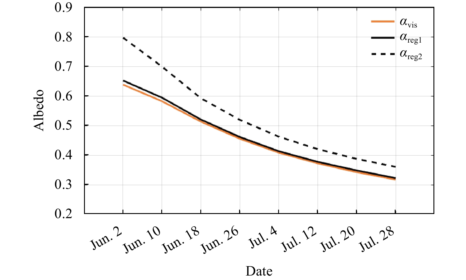
Sediment-laden sea ice plays an important role in Arctic sediment transport and biogeochemical cycles, as well as the shortwave radiation budget and melt onset of ice surface. However, at present, there is a lack of efficient observation approach from both space and in situ for the coverage of Arctic sediment-laden sea ice. Thus, both spatial distribution and long-term changes in area fraction of such ice floes are still unclear. This study proposes a new classification method to extract Arctic sediment-laden sea ice on the basic of the difference in spectral characteristics between sediment-laden sea ice and clean sea ice in the visible band using the MOD09A1 data with the resolution of 500 m, and obtains its area fraction over the pan Arctic Ocean during 2000−2021. Compared with Landsat-8 true color verification images with a resolution of 30 m, the overall accuracy of our classification method is 92.3%, and the Kappa coefficient is 0.84. The impact of clouds on the results of recognition and spatiotemporal changes of sediment-laden sea ice is relatively small from June to July, compared to that in May or August. Spatially, sediment-laden sea ice mostly appears over the marginal seas of the Arctic Ocean, especially the continental shelf of Chukchi Sea and the Siberian Seas. Associated with the retreat of Arctic sea ice extent, the total area of sediment-laden sea ice in June–July also shows a significant decreasing trend of 8.99 × 10⁴ km2 per year. The occurrence of sediment-laden sea ice over the Arctic Ocean in June–July leads to the reduce of surface albedo over the ice-covered ocean by 14.1%. This study will help thoroughly understanding of the role of sediment-laden sea ice in the evolution of Arctic climate system and marine ecological environment, as well as the heat budget and mass balance of sea ice itself.
Sediment-laden sea ice plays an important role in Arctic sediment transport and biogeochemical cycles, as well as the shortwave radiation budget and melt onset of ice surface. However, at present, there is a lack of efficient observation approach from both space and in situ for the coverage of Arctic sediment-laden sea ice. Thus, both spatial distribution and long-term changes in area fraction of such ice floes are still unclear. This study proposes a new classification method to extract Arctic sediment-laden sea ice on the basic of the difference in spectral characteristics between sediment-laden sea ice and clean sea ice in the visible band using the MOD09A1 data with the resolution of 500 m, and obtains its area fraction over the pan Arctic Ocean during 2000−2021. Compared with Landsat-8 true color verification images with a resolution of 30 m, the overall accuracy of our classification method is 92.3%, and the Kappa coefficient is 0.84. The impact of clouds on the results of recognition and spatiotemporal changes of sediment-laden sea ice is relatively small from June to July, compared to that in May or August. Spatially, sediment-laden sea ice mostly appears over the marginal seas of the Arctic Ocean, especially the continental shelf of Chukchi Sea and the Siberian Seas. Associated with the retreat of Arctic sea ice extent, the total area of sediment-laden sea ice in June–July also shows a significant decreasing trend of 8.99 × 10⁴ km2 per year. The occurrence of sediment-laden sea ice over the Arctic Ocean in June–July leads to the reduce of surface albedo over the ice-covered ocean by 14.1%. This study will help thoroughly understanding of the role of sediment-laden sea ice in the evolution of Arctic climate system and marine ecological environment, as well as the heat budget and mass balance of sea ice itself.


, Available online ,
doi: 10.1007/s13131-024-2289-8
Abstract:
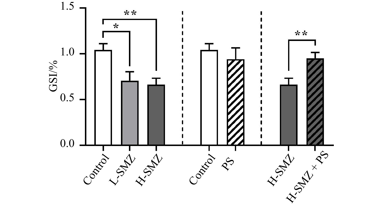
In the coastal environment, the co-occurrence of antibiotic and nanoplastic pollution is common. Investigating their individual and combined toxicity to marine organisms is of great necessity. In the present study, the reproductive toxicity of sulfamethazine (SMZ) and nanoplastics (polystyrene, PS) via the dietary route on the spermatogenesis of marine medaka (Oryzias melastigma) was examined. After 30 days of dietary exposure, SMZ alone decreased the gonadosomatic index (GSI) value (~ 35%) and the proportion of undifferentiated type A spermatogonia (Aund) (~ 40%), probably by disrupting the testicular sex hormone production, the spermatogenesis-related growth factor network and the balance of apoptosis. Individual exposure to PS did not affect the GSI value or the proportions of germ cells at different developmental stages, but dysregulated the expression of several spermatogenesis-related genes. Interestingly, the presence of PS alleviated the decreased GSI value caused by SMZ. This alleviation effect was achieved by enhancing the spermatogonia differentiation instead of reversing the suppressed self-renewal of Aund, suggesting that the mixture of PS and SMZ could cause reproductive effects in a different way. These findings expand our knowledge of threats of ubiquitous antibiotic and nanoplastic pollution to fish reproduction and population.
In the coastal environment, the co-occurrence of antibiotic and nanoplastic pollution is common. Investigating their individual and combined toxicity to marine organisms is of great necessity. In the present study, the reproductive toxicity of sulfamethazine (SMZ) and nanoplastics (polystyrene, PS) via the dietary route on the spermatogenesis of marine medaka (Oryzias melastigma) was examined. After 30 days of dietary exposure, SMZ alone decreased the gonadosomatic index (GSI) value (~ 35%) and the proportion of undifferentiated type A spermatogonia (Aund) (~ 40%), probably by disrupting the testicular sex hormone production, the spermatogenesis-related growth factor network and the balance of apoptosis. Individual exposure to PS did not affect the GSI value or the proportions of germ cells at different developmental stages, but dysregulated the expression of several spermatogenesis-related genes. Interestingly, the presence of PS alleviated the decreased GSI value caused by SMZ. This alleviation effect was achieved by enhancing the spermatogonia differentiation instead of reversing the suppressed self-renewal of Aund, suggesting that the mixture of PS and SMZ could cause reproductive effects in a different way. These findings expand our knowledge of threats of ubiquitous antibiotic and nanoplastic pollution to fish reproduction and population.


, Available online ,
doi: 10.1007/s13131-024-2309-8
Abstract:
The sinking of diatoms is critical to the formation of oceanic biological pumps and coastal hypoxic zones. However, little is known about the effects of different nutrient restrictions on diatom sinking. In this study, we measured the sinking velocity (SV) of Thalassiosira weissflogii using a new phytoplankton video observation instrument and analyzed major biochemical components under varying nutrient conditions. Our results showed that the SV of T. weissflogii under different nutrient limitation conditions varied substantially. The highest SV of (1.77 ± 0.02) m/d was obtained under nitrate limitation, significantly surpassing that under phosphate limitation at (0.98 ± 0.13) m/d. As the nutrient limitation was released, the SV steadily decreased to (0.32 ± 0.03) m/d and (0.15 ± 0.05) m/d, respectively. Notably, under conditions with limited nitrate and phosphate concentrations, the SV values of T. weissflogii significantly positively correlated with the lipid content (P < 0.001), with R2 values of 0.86 and 0.69, respectively. The change of the phytoplankton SV was primarily related to the intracellular composition, which is controlled by nutrient conditions but did not significantly correlate with transparent extracellular polymer and biosilica contents. The results of this study help to understand the regulation of the vertical sinking process of diatoms by nutrient restriction and provide new insights into phytoplankton dynamics and their relationship with the marine nutrient structure.
The sinking of diatoms is critical to the formation of oceanic biological pumps and coastal hypoxic zones. However, little is known about the effects of different nutrient restrictions on diatom sinking. In this study, we measured the sinking velocity (SV) of Thalassiosira weissflogii using a new phytoplankton video observation instrument and analyzed major biochemical components under varying nutrient conditions. Our results showed that the SV of T. weissflogii under different nutrient limitation conditions varied substantially. The highest SV of (1.77 ± 0.02) m/d was obtained under nitrate limitation, significantly surpassing that under phosphate limitation at (0.98 ± 0.13) m/d. As the nutrient limitation was released, the SV steadily decreased to (0.32 ± 0.03) m/d and (0.15 ± 0.05) m/d, respectively. Notably, under conditions with limited nitrate and phosphate concentrations, the SV values of T. weissflogii significantly positively correlated with the lipid content (P < 0.001), with R2 values of 0.86 and 0.69, respectively. The change of the phytoplankton SV was primarily related to the intracellular composition, which is controlled by nutrient conditions but did not significantly correlate with transparent extracellular polymer and biosilica contents. The results of this study help to understand the regulation of the vertical sinking process of diatoms by nutrient restriction and provide new insights into phytoplankton dynamics and their relationship with the marine nutrient structure.


, Available online
Abstract:
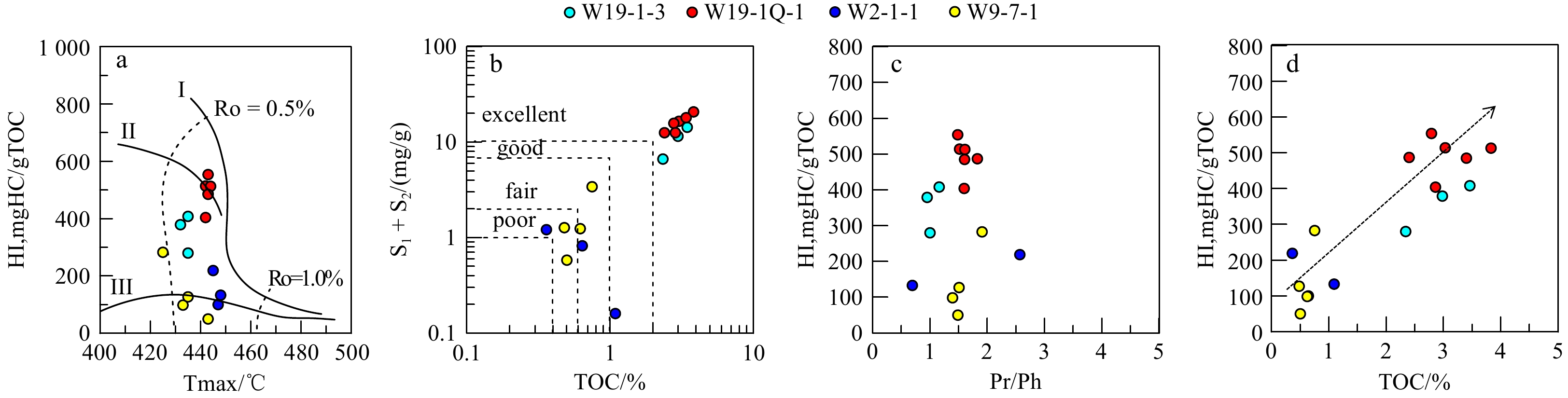
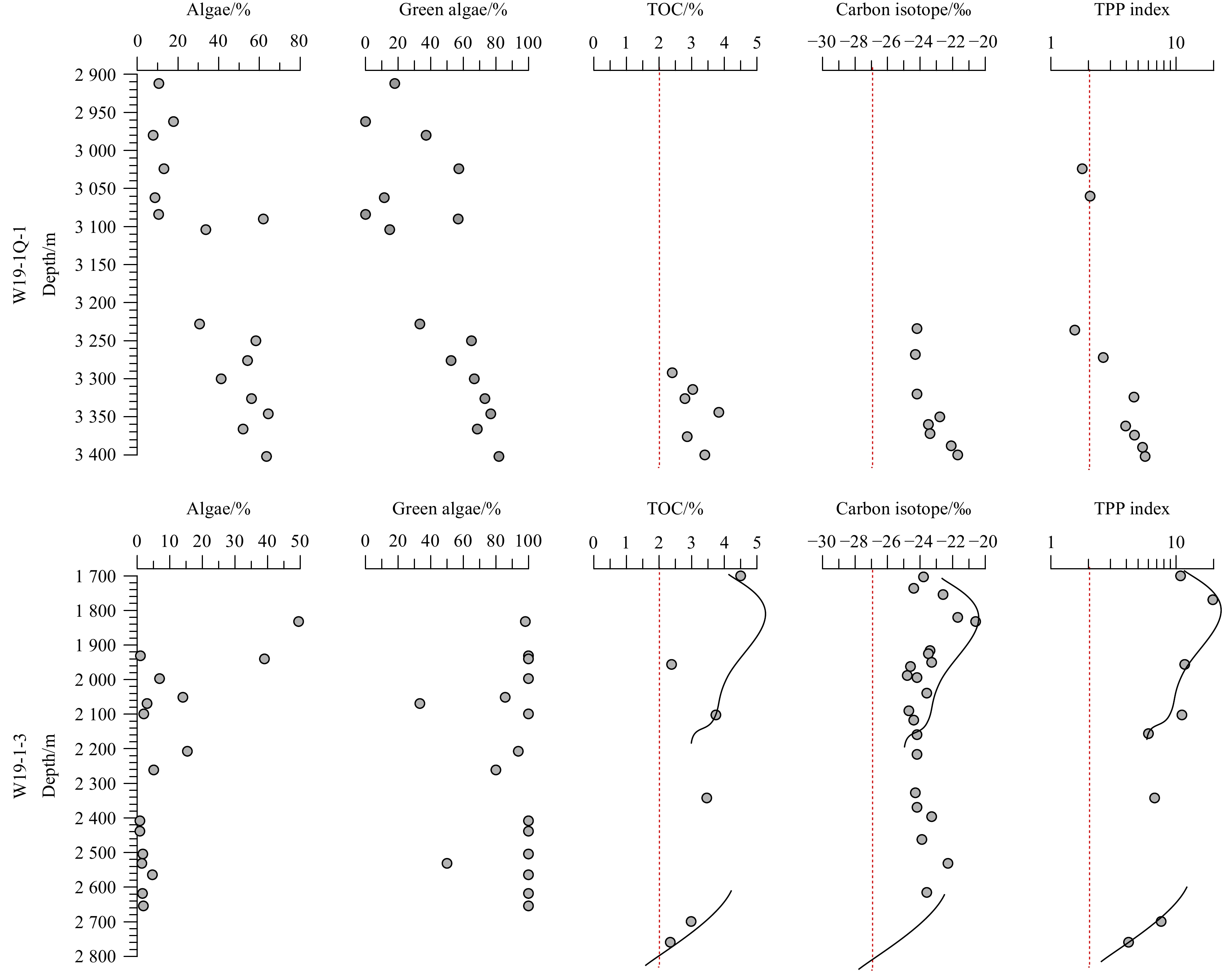
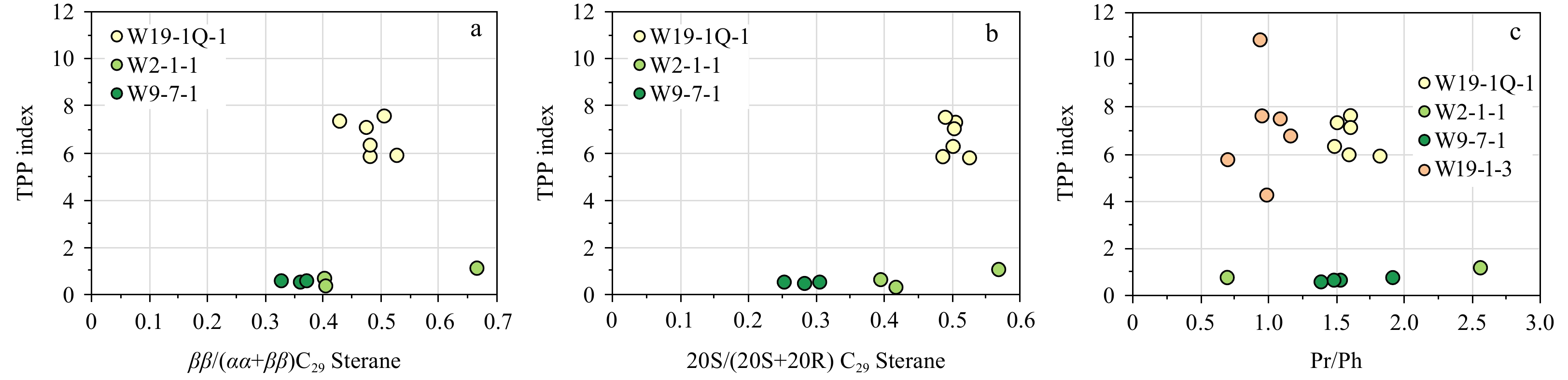
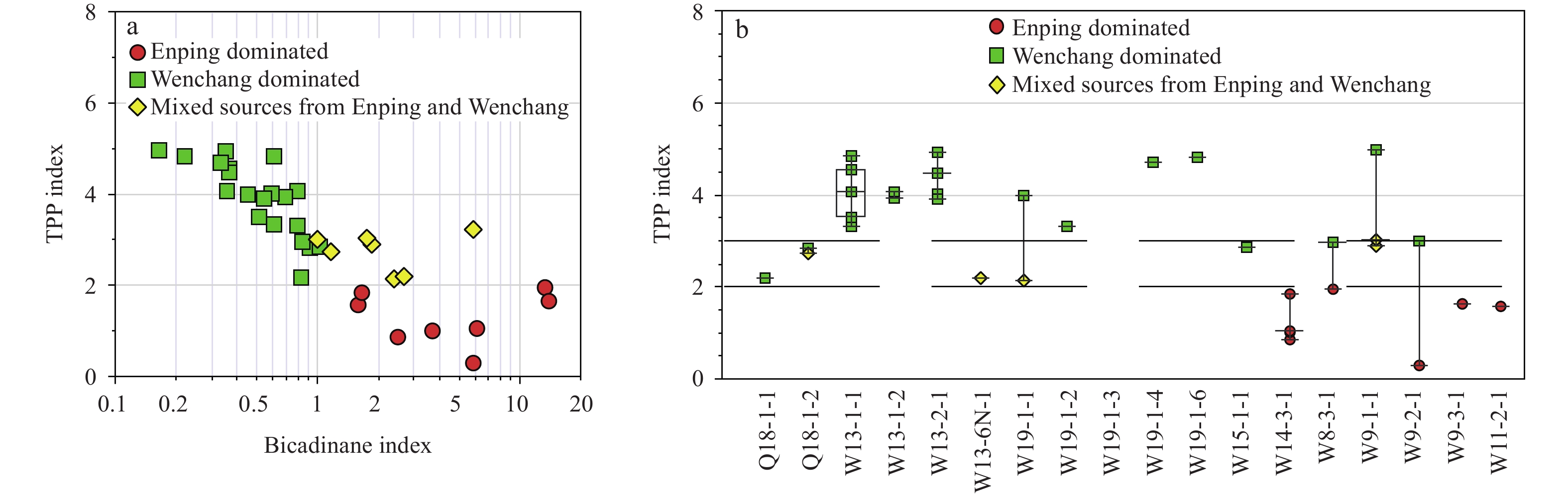
The northern South China Sea, including the Zhujiangkou Basin and the Beibuwan Basin, developed high-quality lacustrine source rocks during the Eocene rifting period. These source rocks are vital for hydrocarbon generation in the northern South China Sea. The Zhu I depression in the Zhujiangkou Basin and the Beibuwan Basin typically exhibit high abundance of C30 4-methyl steranes. However, shales in the Eocene Wenchang Formation in the Zhu III depression of the Zhujiangkou Basin contains lower quantities of high-quality lacustrine source rocks with 4-methyl steranes, which often co-elute with some pentacyclic triterpanes in gas chromatography-mass spectrometry (GC-MS). Therefore, the single 4-methylsterane parameter based on GC-MS cannot accurately distinguish organic source in the deep to semi-deep water lacustrine source rocks of the Wenchang Formation from other source rocks, thus impeding the recognition of their contributions to petroleum reservoirs. In this study, GC-MS of aliphatic hydrocarbons, palynofacies and algal identification, as well as stable carbon isotope data of organic matter were used to identify the algal species and construct the paleoclimate during deposition of the Wenchang Formation source rocks in the Zhu III depression of the Zhujiangkou Basin. It is suggested that during the Wenchang Formation period, freshwater green algae prevailed in the lake, which is likely account for the relatively low content of 4-methyl steranes in the high-quality lacustrine source rocks. Controlled by the algal species, it is proposed that the content of C30 tetracyclic polyprenoids (TPP) can better indicate the quality of the Wenchang source rocks than C30 4-methyl steranes. Consequently, a relationship between the TPP index and the quality of the lacustrine source rocks in the Wenchang Formation of the Zhu III depression was established. A higher TPP index indicates higher organic matter abundance and hydrogen index of the lacustrine source rocks. When applied to the origin analysis of oils in the Zhu III depression, it is believed that the organic-rich deep lacustrine source rocks in the Wenchang Formation made great contribution to the transitional zone crude oils in the Wenchang A and Wenchang B depressions.
The northern South China Sea, including the Zhujiangkou Basin and the Beibuwan Basin, developed high-quality lacustrine source rocks during the Eocene rifting period. These source rocks are vital for hydrocarbon generation in the northern South China Sea. The Zhu I depression in the Zhujiangkou Basin and the Beibuwan Basin typically exhibit high abundance of C30 4-methyl steranes. However, shales in the Eocene Wenchang Formation in the Zhu III depression of the Zhujiangkou Basin contains lower quantities of high-quality lacustrine source rocks with 4-methyl steranes, which often co-elute with some pentacyclic triterpanes in gas chromatography-mass spectrometry (GC-MS). Therefore, the single 4-methylsterane parameter based on GC-MS cannot accurately distinguish organic source in the deep to semi-deep water lacustrine source rocks of the Wenchang Formation from other source rocks, thus impeding the recognition of their contributions to petroleum reservoirs. In this study, GC-MS of aliphatic hydrocarbons, palynofacies and algal identification, as well as stable carbon isotope data of organic matter were used to identify the algal species and construct the paleoclimate during deposition of the Wenchang Formation source rocks in the Zhu III depression of the Zhujiangkou Basin. It is suggested that during the Wenchang Formation period, freshwater green algae prevailed in the lake, which is likely account for the relatively low content of 4-methyl steranes in the high-quality lacustrine source rocks. Controlled by the algal species, it is proposed that the content of C30 tetracyclic polyprenoids (TPP) can better indicate the quality of the Wenchang source rocks than C30 4-methyl steranes. Consequently, a relationship between the TPP index and the quality of the lacustrine source rocks in the Wenchang Formation of the Zhu III depression was established. A higher TPP index indicates higher organic matter abundance and hydrogen index of the lacustrine source rocks. When applied to the origin analysis of oils in the Zhu III depression, it is believed that the organic-rich deep lacustrine source rocks in the Wenchang Formation made great contribution to the transitional zone crude oils in the Wenchang A and Wenchang B depressions.


, Available online
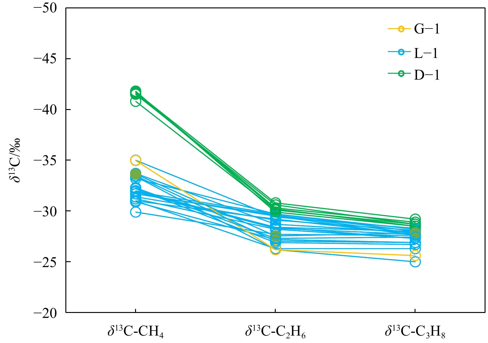
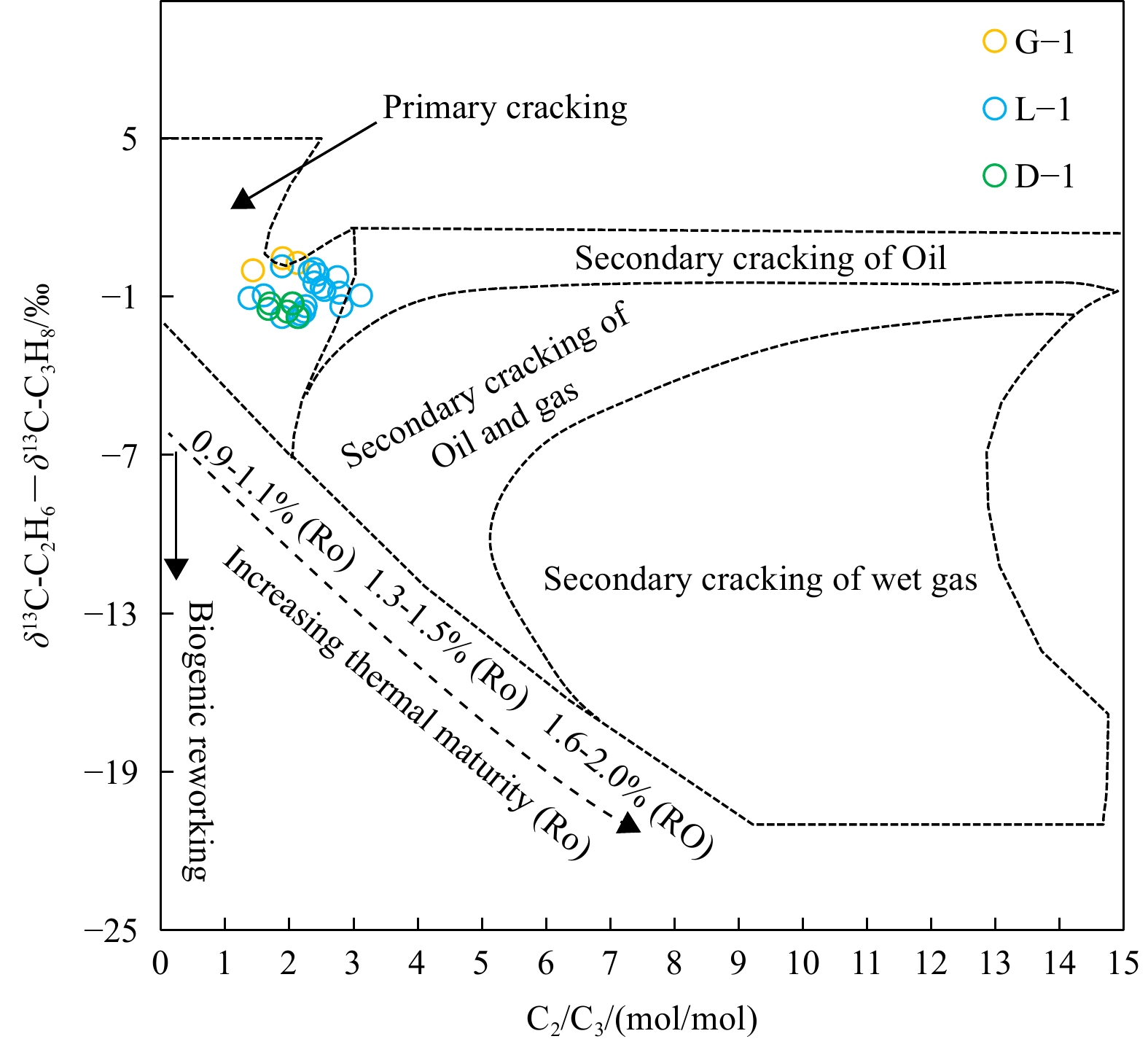
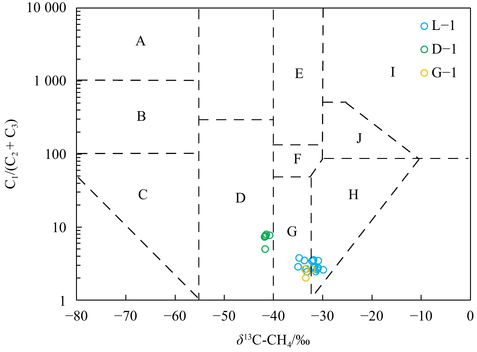
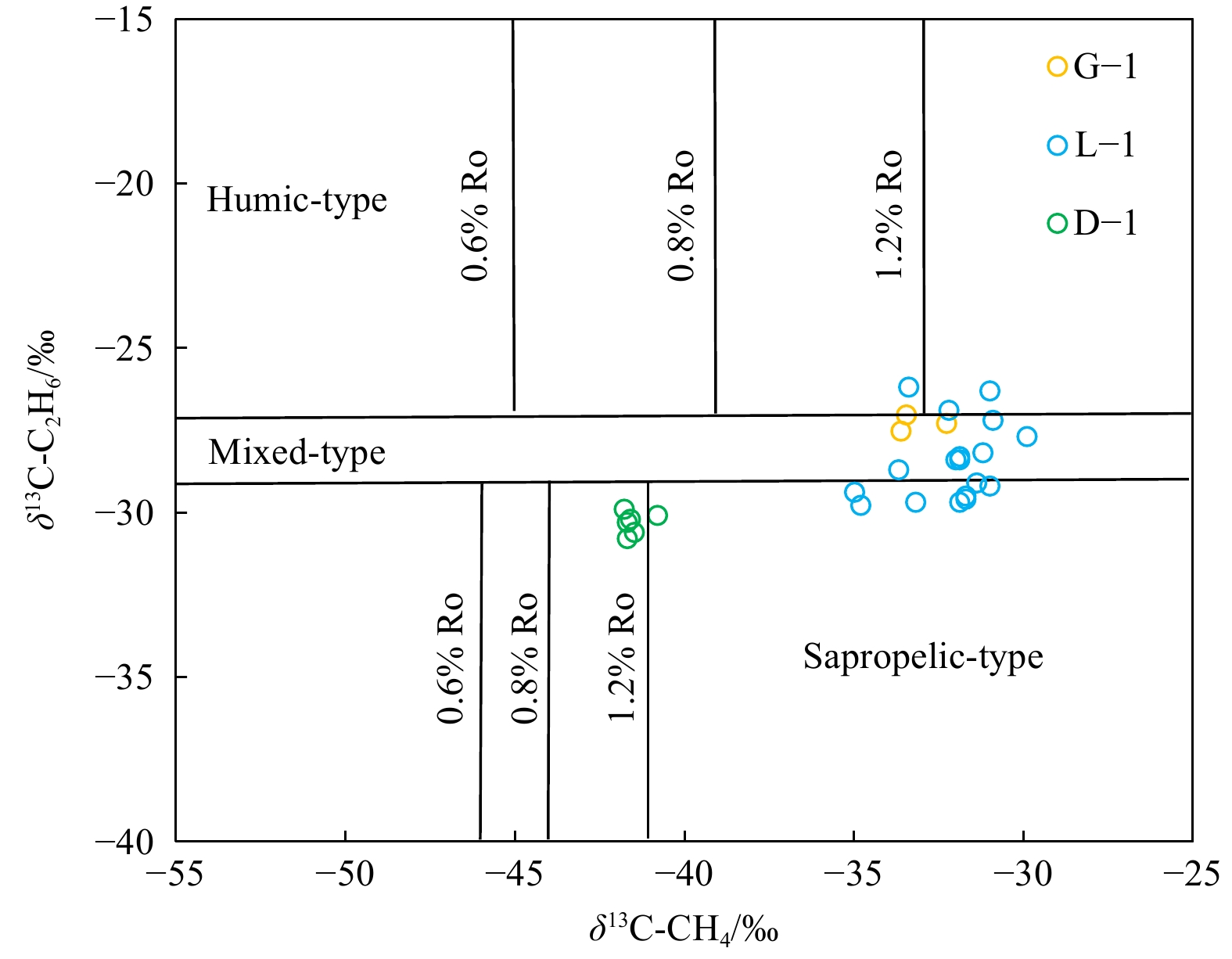
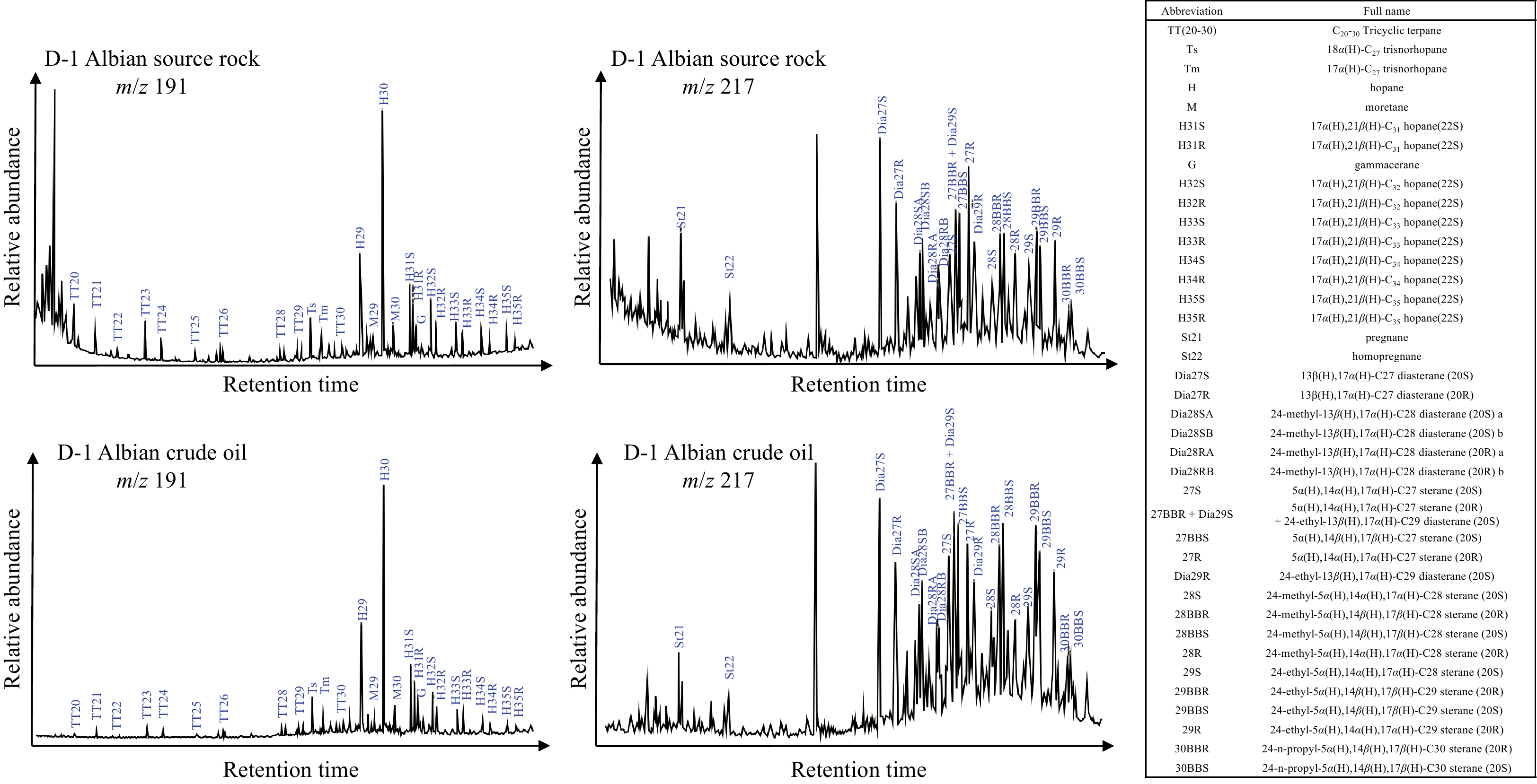
Abstract:
The gas sources in the Eastern Cote d’Ivoire Basin (Tano Basin) are seldom reported and remain controversial due to multiple sets of potential source rocks and poorly documented geochemical characteristics of natural gases. The marine source rock potential from the Upper Albian to Turonian as well as the molecular composition and the stable carbon isotope composition of natural gases in the Eastern Cote d’Ivoire Basin were studied in detail to investigate the origins of natural gases. The total organic carbon (TOC), hydrogen index (HI), and generation potential (S1 + S2) of source rocks indicate that both sapropelic source rocks and humic source rocks developed during the Late Albian, whereas sapropelic source rocks developed during the Cenomanian and the Turonian. The normal order of δ13CH4 < δ13C2H6 < δ13C3H8 (δ13C1 < δ13C2 < δ13C3), the relationship between C2/C3 molar ratio and δ13C2 - δ13C3, and the plot of δ13C1 versus C1/(C2+C3) collectively show that the natural gases are thermogenic due to the primary cracking of kerogen, including the typical oil-associated gases from Well D-1, the mixed oil-associated gases and coal-derived gases from Well G-1 and Well L-1. Based on the plot of δ13C1 versus δ13C2 and the established relationship between δ13C1 and equivalent vitrinite reflectance (Ro), we proposed that the natural gases are in a mature stage (Ro generally varies from 1.0% to 1.3%). Combined with results of basin modelling and oil-to-source correlation, the transitional to marine source rocks during the Late Albian were thought to have made a great contribution to the natural gases. Our study will make a better understanding on petroleum system in the Eastern Cote d’Ivoire Basin.
The gas sources in the Eastern Cote d’Ivoire Basin (Tano Basin) are seldom reported and remain controversial due to multiple sets of potential source rocks and poorly documented geochemical characteristics of natural gases. The marine source rock potential from the Upper Albian to Turonian as well as the molecular composition and the stable carbon isotope composition of natural gases in the Eastern Cote d’Ivoire Basin were studied in detail to investigate the origins of natural gases. The total organic carbon (TOC), hydrogen index (HI), and generation potential (S1 + S2) of source rocks indicate that both sapropelic source rocks and humic source rocks developed during the Late Albian, whereas sapropelic source rocks developed during the Cenomanian and the Turonian. The normal order of δ13CH4 < δ13C2H6 < δ13C3H8 (δ13C1 < δ13C2 < δ13C3), the relationship between C2/C3 molar ratio and δ13C2 - δ13C3, and the plot of δ13C1 versus C1/(C2+C3) collectively show that the natural gases are thermogenic due to the primary cracking of kerogen, including the typical oil-associated gases from Well D-1, the mixed oil-associated gases and coal-derived gases from Well G-1 and Well L-1. Based on the plot of δ13C1 versus δ13C2 and the established relationship between δ13C1 and equivalent vitrinite reflectance (Ro), we proposed that the natural gases are in a mature stage (Ro generally varies from 1.0% to 1.3%). Combined with results of basin modelling and oil-to-source correlation, the transitional to marine source rocks during the Late Albian were thought to have made a great contribution to the natural gases. Our study will make a better understanding on petroleum system in the Eastern Cote d’Ivoire Basin.


, Available online ,
doi: 10.1007/s13131-024-2313-z
Abstract:
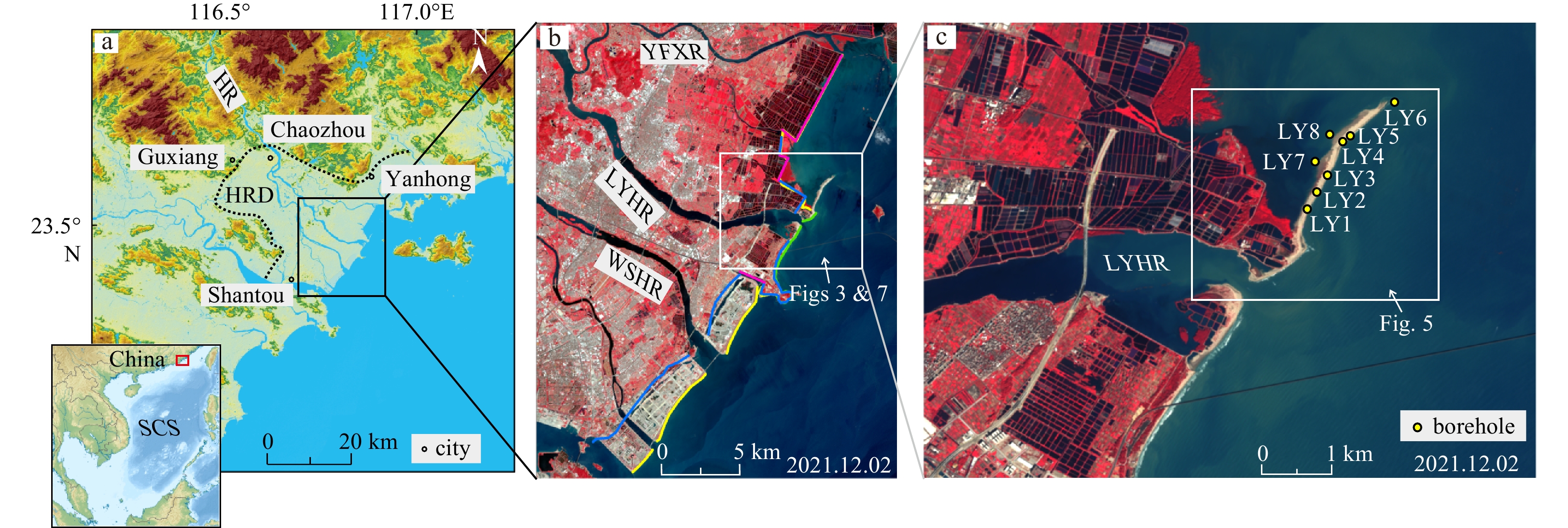
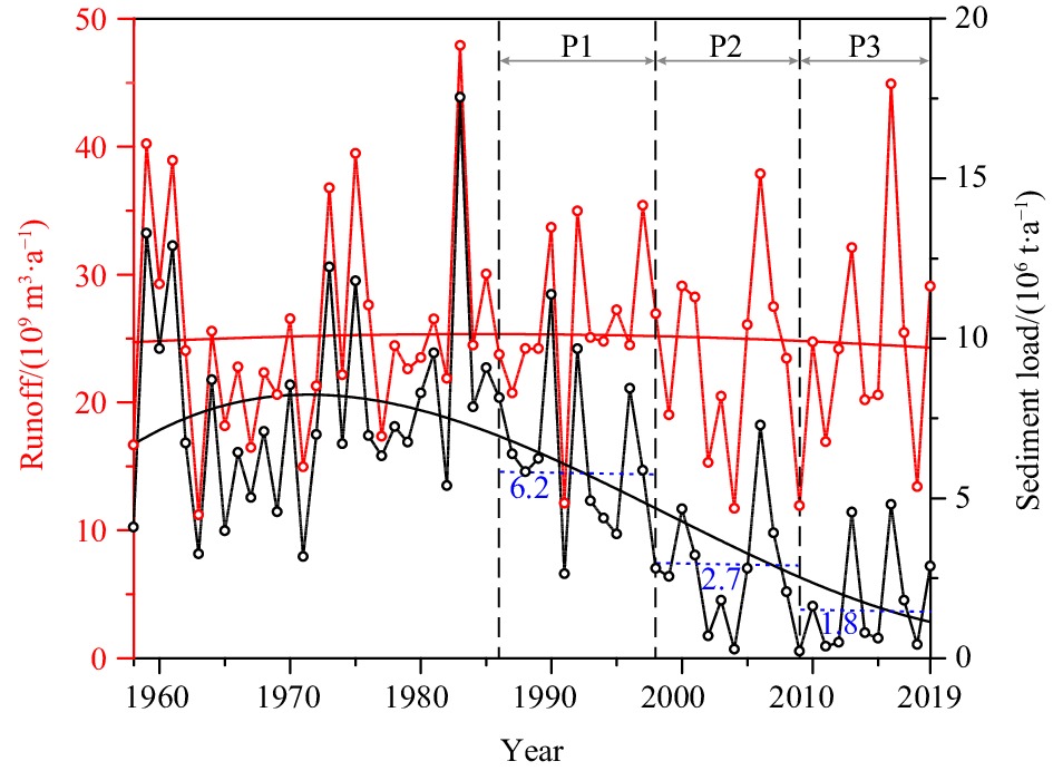
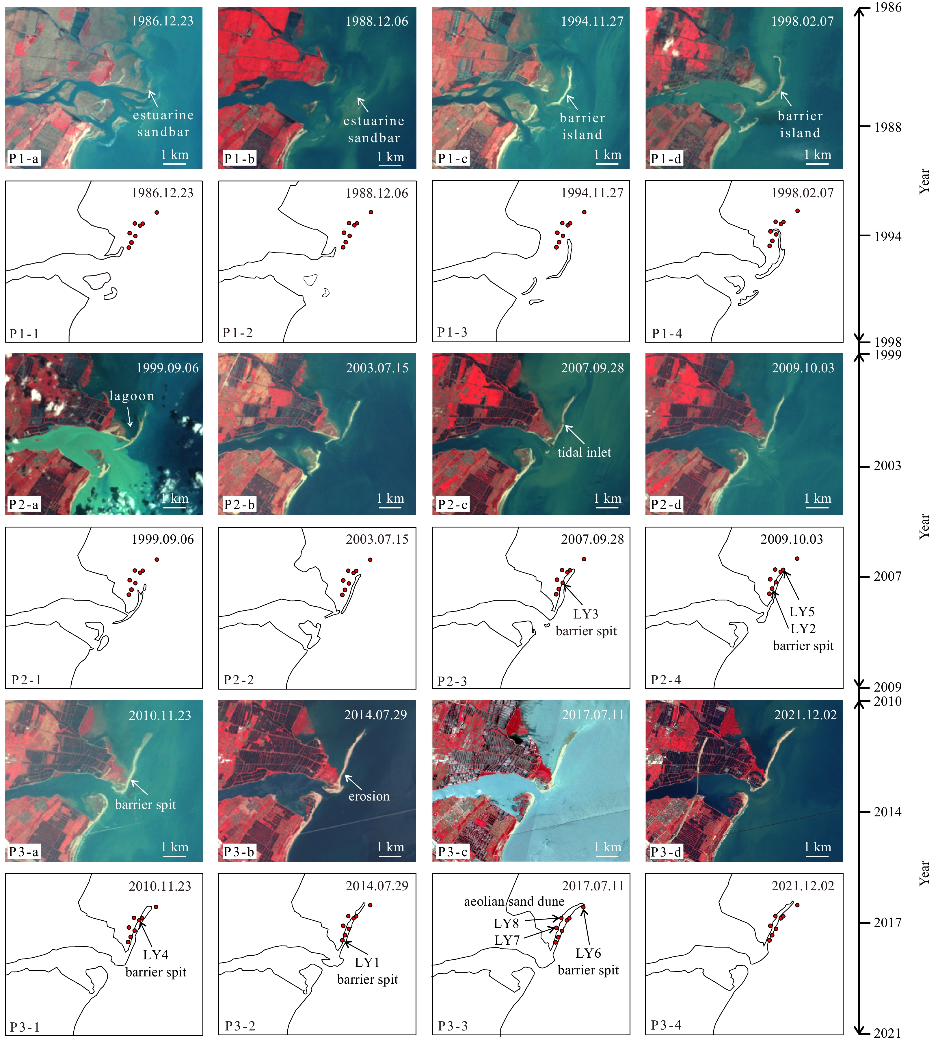
The deltas serve as the primary interactive zone where terrestrial and marine environments converge, playing a pivotal role in the coastal deposition. In the Holocene, climate changes and sea level fluctuation are the principal driving factors in the evolution of deltas. However, human activities such as the construction of dams and reservoirs in the Anthropocene have significantly altered sediment transport in rivers, leading to depositional pattern variation during deltaic evolution. In this study, we have conducted a comparative analysis of the morphological variations (1986–2021) in the barrier system of the Hanjiang River Delta (HRD) using satellite remote sensing (SRS) method. Additionally, we have examined the lithological changes and facies alterations observed in eight boreholes on the present barrier spit. Our findings indicate that the intensification of anthropogenic activities led to a significant reduction in the sediment flux of the Hanjiang River (HR), resulting in depocenter landward migration at the estuary. SRS analysis reveals their periodical morphological characteristics and spatial variations of estuarine sandbars (1986–1992), barrier islands-lagoons (1993–2009), and barrier spits (2010–2021) during 1986 to 2021. The stratigraphy of boreholes demonstrates a south-to-north facies transition from lagoon to lagoon-barrier spit and barrier spit in vertical lithology. Therefore, the depositional evolution of the HRD barrier system is categorized into three phases: estuarine sandbar-barrier island phase (1986–1998); barrier island-lagoon phase (1999–2009); and barrier spit phase (2010–2021). During the estuarine sandbar-barrier island phase, fluvial processes played a predominate role in the deposition. Consequently, with a significant decrease in river sediment load, the dominant factors driving depositional processes shifted towards wave action and alongshore current. Based on the conceptual model in the Holocene, we propose a modified depositional model of wave-dominated deltas during Anthropocene that encompasses three evolutionary phases: estuarine sandbars and delta front platforms, barrier island-lagoon formation and landward migration of barrier spits. This pattern highlights that human-induced reduction in river sediment flux has led to a seaward deltaic progradation driven by barrier landward migration.
The deltas serve as the primary interactive zone where terrestrial and marine environments converge, playing a pivotal role in the coastal deposition. In the Holocene, climate changes and sea level fluctuation are the principal driving factors in the evolution of deltas. However, human activities such as the construction of dams and reservoirs in the Anthropocene have significantly altered sediment transport in rivers, leading to depositional pattern variation during deltaic evolution. In this study, we have conducted a comparative analysis of the morphological variations (1986–2021) in the barrier system of the Hanjiang River Delta (HRD) using satellite remote sensing (SRS) method. Additionally, we have examined the lithological changes and facies alterations observed in eight boreholes on the present barrier spit. Our findings indicate that the intensification of anthropogenic activities led to a significant reduction in the sediment flux of the Hanjiang River (HR), resulting in depocenter landward migration at the estuary. SRS analysis reveals their periodical morphological characteristics and spatial variations of estuarine sandbars (1986–1992), barrier islands-lagoons (1993–2009), and barrier spits (2010–2021) during 1986 to 2021. The stratigraphy of boreholes demonstrates a south-to-north facies transition from lagoon to lagoon-barrier spit and barrier spit in vertical lithology. Therefore, the depositional evolution of the HRD barrier system is categorized into three phases: estuarine sandbar-barrier island phase (1986–1998); barrier island-lagoon phase (1999–2009); and barrier spit phase (2010–2021). During the estuarine sandbar-barrier island phase, fluvial processes played a predominate role in the deposition. Consequently, with a significant decrease in river sediment load, the dominant factors driving depositional processes shifted towards wave action and alongshore current. Based on the conceptual model in the Holocene, we propose a modified depositional model of wave-dominated deltas during Anthropocene that encompasses three evolutionary phases: estuarine sandbars and delta front platforms, barrier island-lagoon formation and landward migration of barrier spits. This pattern highlights that human-induced reduction in river sediment flux has led to a seaward deltaic progradation driven by barrier landward migration.


, Available online ,
doi: 10.1007/s13131-023-2272-9
Abstract:
The Caroline Plate is located among the Pacific Plate, the Philippine Sea Plate, and the India Australia Plate, and plays a key role in controlling the spreading direction of the Philippine Sea Plate. The Caroline Submarine Plateau (or Caroline Ridge) and the Eauripik Rise on the south formed a remarkable T-shaped large igneous rock province, which covered the northern boundary between the Caroline Plate and the Pacific Plate. However, relationship between these tectonic units and magma evolution remains unclear. Based on magnetic data from the Earth Magnetic Anomaly Grid (2-arc-minute resolution) (V2), the normalized vertical derivative of the total horizontal derivative (NVDR-THDR) technique was used to study the boundary of the Caroline Plate. Results show that the northern boundary is a transform fault that runs 1400 km long in approximately 28 km wide along the N8° in E-W direction. The eastern boundary is an NNW-SSE trending fault zone and subduction zone with a width of tens to hundreds of kilometers; and the north of N4° is a fracture zone of dense faults. The southeastern boundary may be the Lyra Trough. The area between the southwestern part of the Caroline Plate and the Ayu Trough is occupied by a wide shear zone up to 100 km wide in nearly S-N trending in general. The Eauripik transform fault (ETF) in the center of the Caroline Plate and the fault zones in the east and west basins are mostly semi-parallel sinistral NNW-SSE–trending faults, which together with the eastern boundary Mussau Trench sinistral fault, the northern Caroline transform fault, and the southern shear zone of the western boundary, indicates the sinistral characteristics of the Caroline Plate. The Caroline hotspot erupted in the Pacific Plate near the Caroline transform fault and formed the West Caroline Ridge, and then joined with the Caroline transform fault at the N8°. A large amount of magma erupted along the Caroline transform fault, by which the East Caroline Ridge was formed. At the same time, a large amount of magma developed southward via the eastern branch of the ETF, forming the northern segment of the Eauripik Rise. Therefore, the magmatic activity of the T-shaped large igneous province is obviously related to the fault structure of the boundary faults between the Caroline Plate and Pacific Plate, and the active faults within the Caroline Plate.
The Caroline Plate is located among the Pacific Plate, the Philippine Sea Plate, and the India Australia Plate, and plays a key role in controlling the spreading direction of the Philippine Sea Plate. The Caroline Submarine Plateau (or Caroline Ridge) and the Eauripik Rise on the south formed a remarkable T-shaped large igneous rock province, which covered the northern boundary between the Caroline Plate and the Pacific Plate. However, relationship between these tectonic units and magma evolution remains unclear. Based on magnetic data from the Earth Magnetic Anomaly Grid (2-arc-minute resolution) (V2), the normalized vertical derivative of the total horizontal derivative (NVDR-THDR) technique was used to study the boundary of the Caroline Plate. Results show that the northern boundary is a transform fault that runs 1400 km long in approximately 28 km wide along the N8° in E-W direction. The eastern boundary is an NNW-SSE trending fault zone and subduction zone with a width of tens to hundreds of kilometers; and the north of N4° is a fracture zone of dense faults. The southeastern boundary may be the Lyra Trough. The area between the southwestern part of the Caroline Plate and the Ayu Trough is occupied by a wide shear zone up to 100 km wide in nearly S-N trending in general. The Eauripik transform fault (ETF) in the center of the Caroline Plate and the fault zones in the east and west basins are mostly semi-parallel sinistral NNW-SSE–trending faults, which together with the eastern boundary Mussau Trench sinistral fault, the northern Caroline transform fault, and the southern shear zone of the western boundary, indicates the sinistral characteristics of the Caroline Plate. The Caroline hotspot erupted in the Pacific Plate near the Caroline transform fault and formed the West Caroline Ridge, and then joined with the Caroline transform fault at the N8°. A large amount of magma erupted along the Caroline transform fault, by which the East Caroline Ridge was formed. At the same time, a large amount of magma developed southward via the eastern branch of the ETF, forming the northern segment of the Eauripik Rise. Therefore, the magmatic activity of the T-shaped large igneous province is obviously related to the fault structure of the boundary faults between the Caroline Plate and Pacific Plate, and the active faults within the Caroline Plate.


, Available online ,
doi: 10.1007/s13131-023-2273-8
Abstract:
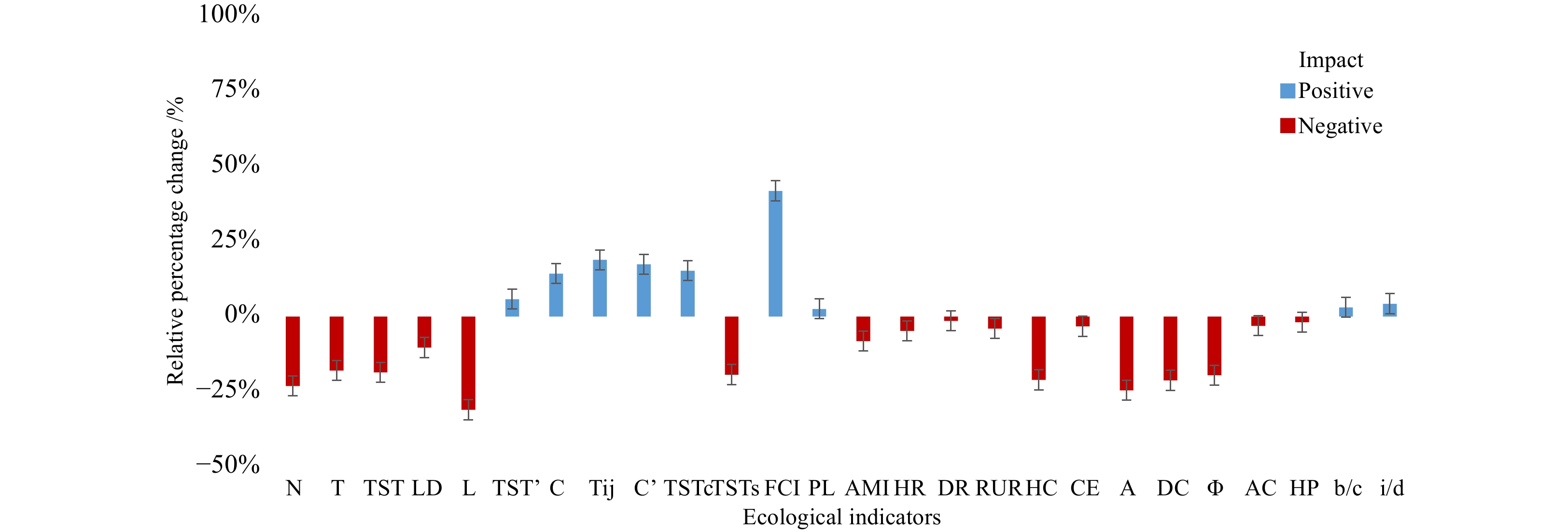
Climate change has led to significant fluctuations in marine ecosystems, including alterations in the structure and function of food webs and ecosystem status. Coastal ecosystems are critical to the functioning of the earth’s life-supporting systems. However, temporal variations in most of these ecosystems have remained unclear so far. In this study, we employed a linear inverse model with Markov Chain Monte Carlo (LIM-MCMC) combined with ecological network analysis (ENA) to reveal the temporal variations of the food web in Haizhou Bay of China. Food webs were constructed based on diet composition data in this ecosystem during the year of 2011 and 2018. Results indicated that there were obvious temporal variations in the composition of food webs in autumn of 2011 and 2018. The number of prey and predators for most species in food web decreased in 2018 compared with 2011, especially for Trichiurus lepturus, zooplankton, Amblychaeturichthys hexanema, and Loligo sp. ENA showed that the complexity of food web structure could be reflected by comprehensive analysis of compartmentalized indicators. Haizhou Bay ecosystem was more mature and stable in 2011, while the ecosystem’s self-sustainability and recovery from disturbances were accelerated from 2011 to 2018. These findings contribute to our understanding of the dynamics of marine ecosystems and highlight the importance of comprehensive analysis of marine food webs. This work provides a framework for assessing and comparing temporal variations in marine ecosystems, which provides essential information and scientific guidance for the Ecosystem-based Fisheries Management (EBFM).
Climate change has led to significant fluctuations in marine ecosystems, including alterations in the structure and function of food webs and ecosystem status. Coastal ecosystems are critical to the functioning of the earth’s life-supporting systems. However, temporal variations in most of these ecosystems have remained unclear so far. In this study, we employed a linear inverse model with Markov Chain Monte Carlo (LIM-MCMC) combined with ecological network analysis (ENA) to reveal the temporal variations of the food web in Haizhou Bay of China. Food webs were constructed based on diet composition data in this ecosystem during the year of 2011 and 2018. Results indicated that there were obvious temporal variations in the composition of food webs in autumn of 2011 and 2018. The number of prey and predators for most species in food web decreased in 2018 compared with 2011, especially for Trichiurus lepturus, zooplankton, Amblychaeturichthys hexanema, and Loligo sp. ENA showed that the complexity of food web structure could be reflected by comprehensive analysis of compartmentalized indicators. Haizhou Bay ecosystem was more mature and stable in 2011, while the ecosystem’s self-sustainability and recovery from disturbances were accelerated from 2011 to 2018. These findings contribute to our understanding of the dynamics of marine ecosystems and highlight the importance of comprehensive analysis of marine food webs. This work provides a framework for assessing and comparing temporal variations in marine ecosystems, which provides essential information and scientific guidance for the Ecosystem-based Fisheries Management (EBFM).


, Available online
Abstract:
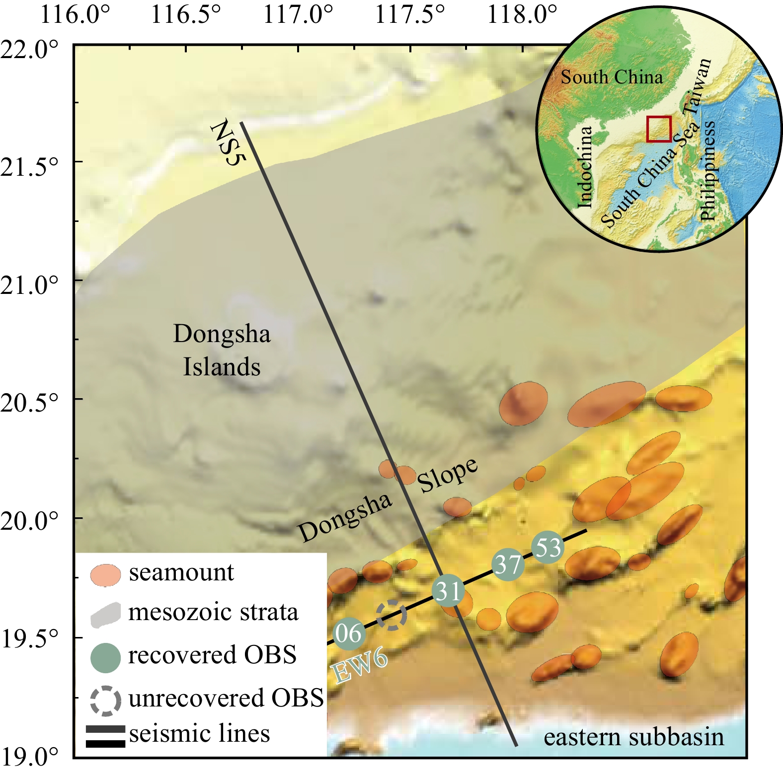
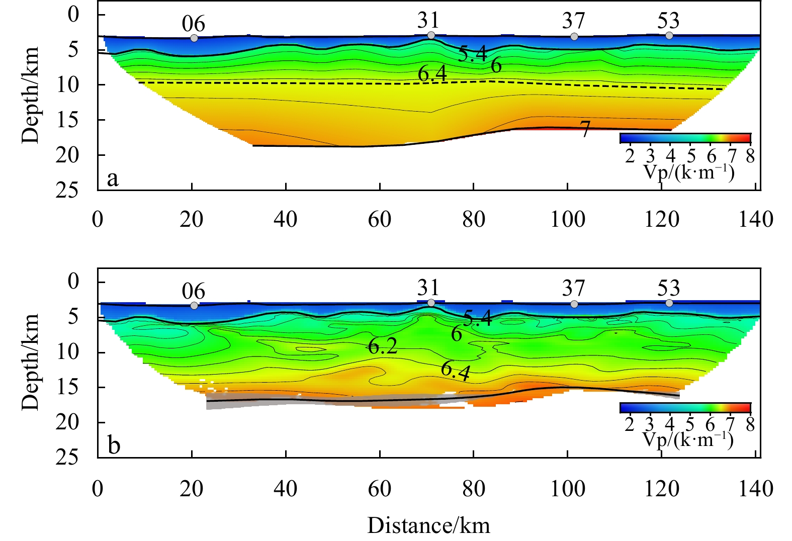
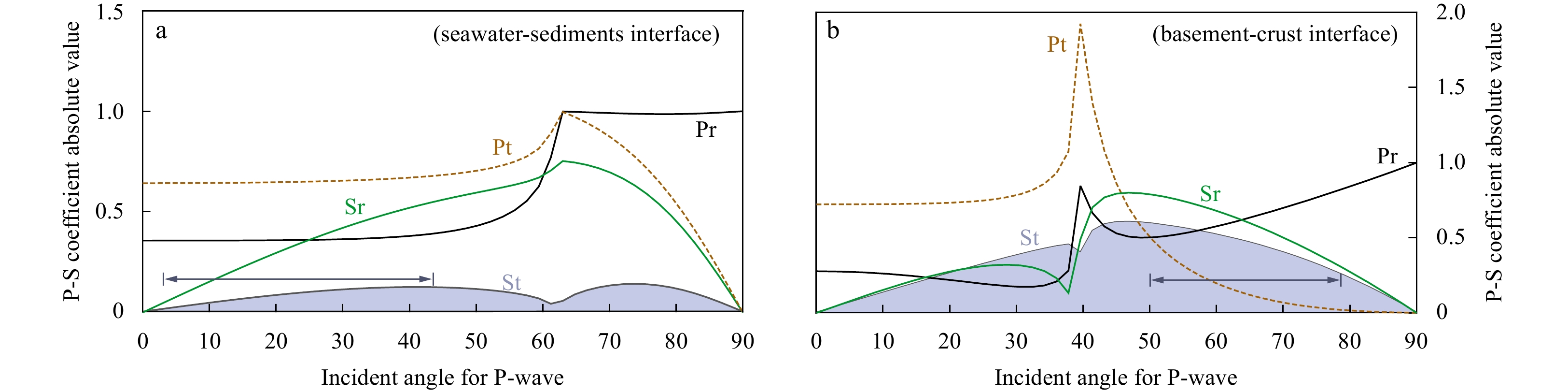
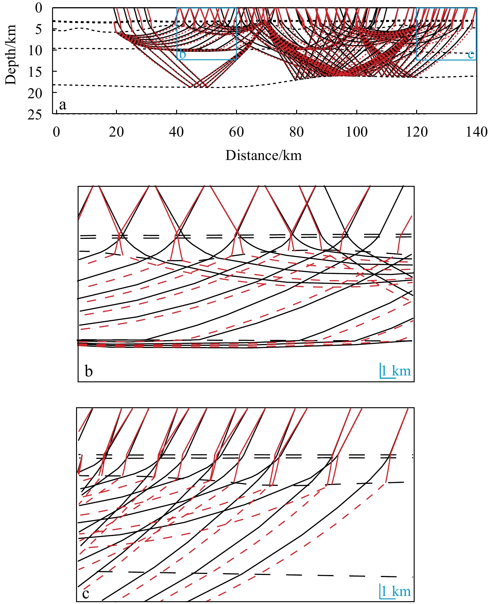
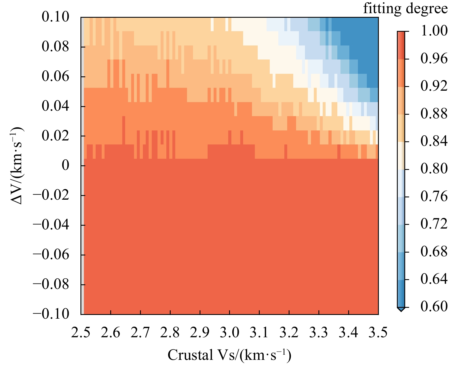
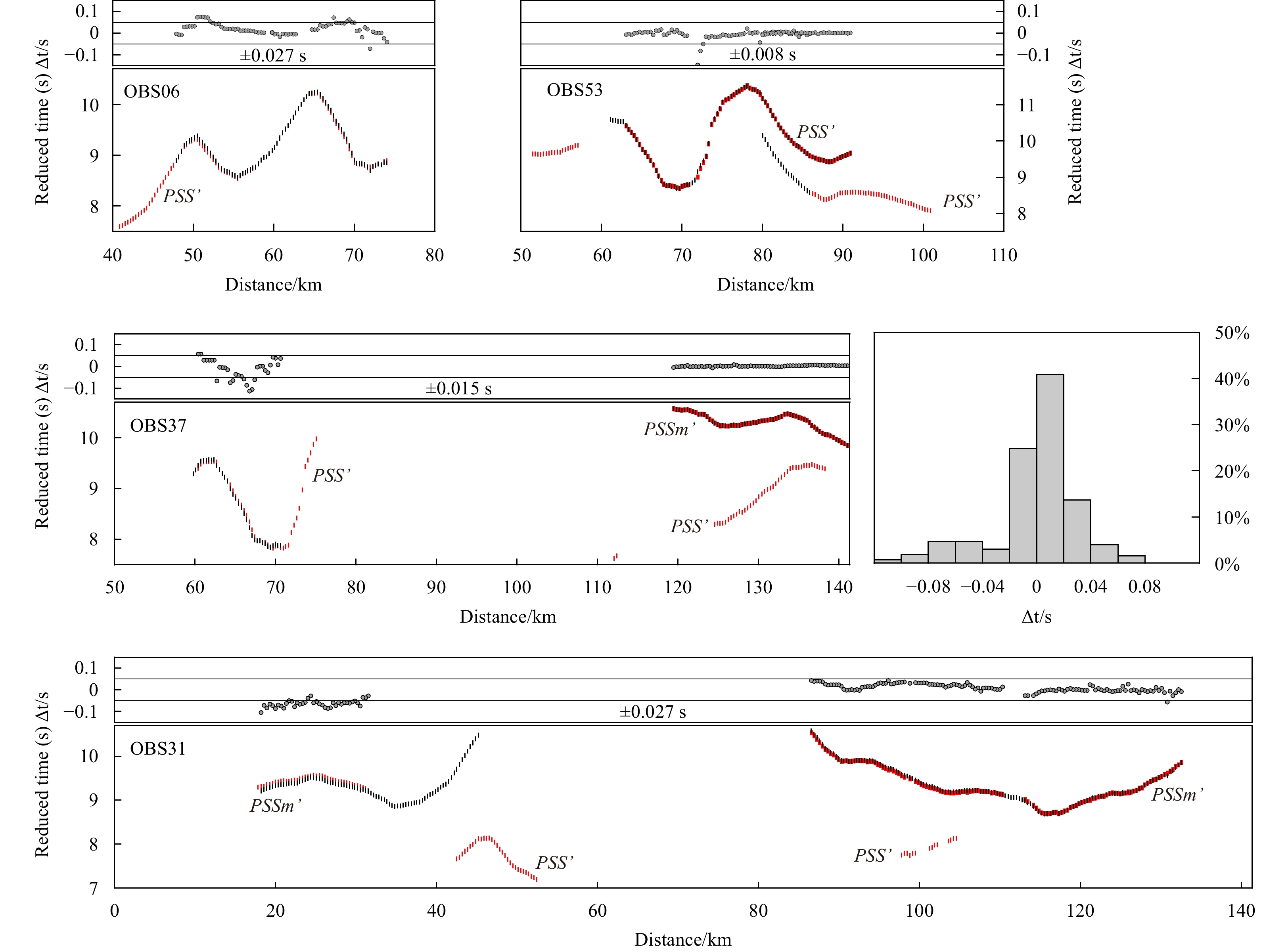
Studies of converted S-wave data recorded on the Ocean Bottom Seismometer (OBS) allow for the estimation of crustal S-wave velocity, from which is further derived the Vp/Vs ratio to constrain the crustal lithology and geophysical properties. Constructing a precise S-wave velocity model is important for deep structural research, and inversion of converted S-waves provides a potential solution. However, the inversion of the converted S-wave remains a weakness because of the complexity of the seismic ray path and the inconsistent conversion interface. In this study, we introduced two travel time correction methods for the S-wave velocity inversion and imaged different S-wave velocity structures in accordance with the corresponding corrected S-wave phases using seismic data of profile EW6 in the northeastern South China Sea (SCS). The two inversion models show a similar trend in velocities, and the velocity difference is < 0.15 km/s (mostly in the range of 0–0.1 km/s), indicating the accuracy of the two travel time correction methods and the reliability of the inversion results. According to simulations of seismic ray tracing based on different models, the velocity of sediments is the primary influencing factor in ray tracing for S-wave phases. If the sedimentary layer has high velocities, the near offset crustal S-wave refractions cannot be traced. In contrast, the ray tracing of Moho S-wave reflections was not significantly impacted by the velocity of the sediments. The two travel time correction methods have their own advantages, and the application of different approaches is based on additional requirements. These works provide an important reference for future improvements in converted S-wave research.
Studies of converted S-wave data recorded on the Ocean Bottom Seismometer (OBS) allow for the estimation of crustal S-wave velocity, from which is further derived the Vp/Vs ratio to constrain the crustal lithology and geophysical properties. Constructing a precise S-wave velocity model is important for deep structural research, and inversion of converted S-waves provides a potential solution. However, the inversion of the converted S-wave remains a weakness because of the complexity of the seismic ray path and the inconsistent conversion interface. In this study, we introduced two travel time correction methods for the S-wave velocity inversion and imaged different S-wave velocity structures in accordance with the corresponding corrected S-wave phases using seismic data of profile EW6 in the northeastern South China Sea (SCS). The two inversion models show a similar trend in velocities, and the velocity difference is < 0.15 km/s (mostly in the range of 0–0.1 km/s), indicating the accuracy of the two travel time correction methods and the reliability of the inversion results. According to simulations of seismic ray tracing based on different models, the velocity of sediments is the primary influencing factor in ray tracing for S-wave phases. If the sedimentary layer has high velocities, the near offset crustal S-wave refractions cannot be traced. In contrast, the ray tracing of Moho S-wave reflections was not significantly impacted by the velocity of the sediments. The two travel time correction methods have their own advantages, and the application of different approaches is based on additional requirements. These works provide an important reference for future improvements in converted S-wave research.


, Available online ,
doi: 10.1007/s13131-023-2245-z
Abstract:
Petroleum hydrocarbon pollution is a global concern, particularly in coastal environments. Polycyclic aromatic hydrocarbons (PAHs) are regarded as the most toxic components of petroleum hydrocarbons. In this study, the biomonitoring and ranking effects of petroleum hydrocarbons and PAHs on the marine fish model Oryzias melastigma embryos were determined in the Jiulong River Estuary (JRE) and its adjacent waters in China. The results showed that the levels of petroleum hydrocarbons from almost all sites met the primary standard for marine seawater quality, and the concentrations of the 16 priority PAHs in the surface seawaters were lower compared with those in other coastal areas worldwide. A new fish expert system based on the embryotoxicity of O. melastigma (OME-FES) was developed and applied in the field to evaluate the biological effects of petroleum hydrocarbons and PAHs. The selected physiological index and molecular indicators in OME-FES were appropriate biomarkers for indicating the harmful effects of petroleum hydrocarbons and PAHs. The outcome of OME-FES revealed that the biological effect levels of the sampling sites ranged from level I (no stress) to level III (medium stress), which is further corroborated by the findings of nested analysis of variance (ANOVA) models. Our results suggest that the OME-FES is an effective tool for evaluating and ranking the biological effects of marine petroleum hydrocarbons and PAHs. This method may also be applied to evaluate other marine pollutants based on its framework.
Petroleum hydrocarbon pollution is a global concern, particularly in coastal environments. Polycyclic aromatic hydrocarbons (PAHs) are regarded as the most toxic components of petroleum hydrocarbons. In this study, the biomonitoring and ranking effects of petroleum hydrocarbons and PAHs on the marine fish model Oryzias melastigma embryos were determined in the Jiulong River Estuary (JRE) and its adjacent waters in China. The results showed that the levels of petroleum hydrocarbons from almost all sites met the primary standard for marine seawater quality, and the concentrations of the 16 priority PAHs in the surface seawaters were lower compared with those in other coastal areas worldwide. A new fish expert system based on the embryotoxicity of O. melastigma (OME-FES) was developed and applied in the field to evaluate the biological effects of petroleum hydrocarbons and PAHs. The selected physiological index and molecular indicators in OME-FES were appropriate biomarkers for indicating the harmful effects of petroleum hydrocarbons and PAHs. The outcome of OME-FES revealed that the biological effect levels of the sampling sites ranged from level I (no stress) to level III (medium stress), which is further corroborated by the findings of nested analysis of variance (ANOVA) models. Our results suggest that the OME-FES is an effective tool for evaluating and ranking the biological effects of marine petroleum hydrocarbons and PAHs. This method may also be applied to evaluate other marine pollutants based on its framework.


, Available online ,
doi: 10.1007/s13131-024-2311-1
Abstract:
Massive bodies of low-oxygen bottom waters are found in coastal areas worldwide, which are detrimental to coastal ecosystems. In summer 2020, the response of coastal hypoxia to extreme weather events, including a catastrophic flooding, an extreme marine heatwave, and typhoon Bavi, is investigated based on multiple satellite, four cruises, and mooring observations. The extensive fan-shaped hypoxia zone presents significant northward extension during July−September 2020, and is estimated as large as 13 000 km2 with rather low oxygen minimum (0.42 mg/L) during its peak in 28−30 August. This severe hypoxia is attributed to the persistent strong stratification, which is indicated by flood-induced larger amount of riverine freshwater input and subsequent marine heatwave off the Changjiang Estuary. Moreover, the typhoon Bavi has limited effect on the marine heatwave and coastal hypoxia in summer 2020.
Massive bodies of low-oxygen bottom waters are found in coastal areas worldwide, which are detrimental to coastal ecosystems. In summer 2020, the response of coastal hypoxia to extreme weather events, including a catastrophic flooding, an extreme marine heatwave, and typhoon Bavi, is investigated based on multiple satellite, four cruises, and mooring observations. The extensive fan-shaped hypoxia zone presents significant northward extension during July−September 2020, and is estimated as large as 13 000 km2 with rather low oxygen minimum (0.42 mg/L) during its peak in 28−30 August. This severe hypoxia is attributed to the persistent strong stratification, which is indicated by flood-induced larger amount of riverine freshwater input and subsequent marine heatwave off the Changjiang Estuary. Moreover, the typhoon Bavi has limited effect on the marine heatwave and coastal hypoxia in summer 2020.


, Available online
Abstract:
The genus Marinobacter is very broadly distributed in global environments and is considered as aerobic heterotroph. In this study, six Marinobacter strains were identified with autotrophic thiosulfate oxidation capacity. These strains, namely Marinobacter guineae M3BT, Marinobacter aromaticivorans D15-8PT, Marinobacter vulgaris F01T, Marinobacter profundi PWS21T, Marinobacter denitrificans JB02H27T, and Marinobacter sp. ST-1M (with a 99.93 % similarity to the 16S rDNA sequences of Marinobacter salsuginis SD-14BT), were screened out of 32 Marinobacter strains by autotrophic thiosulfate oxidization medium. The population of cells grew in a chemolithotrophic medium, increasing from 105 to 107 cells /mL within 5 days. This growth was accompanied by the consumption of thiosulfate 3.59 mM to 9.64 mM and the accumulation of sulfate up to 0.96 mM, and occasionally produced sulfur containing complex particles. Among these Marinobacter strains, it was also found their capability of oxidizing thiosulfate to sulfate in a heterotrophic medium. Notably, M. vulgaris F01T and M. antarcticus ZS2-30T showed highly significant production of sulfate at 9.45 mM and 3.10 mM. Genome annotation indicated that these Marinobacter strains possess a complete Sox cluster for thiosulfate oxidation. Further phylogenetic analysis of the soxB gene revealed that six Marinobacter strains formed a separate lineage within Gammaproteobacteria and close to obligate chemolithoautotroph Thiomicrorhabdus arctica. The results indicated that thiosulfate oxidizing and chemolithoautotrophic potential in Marinobacter genus, which may contribute to the widespread of Marinobacter in the global ocean.
The genus Marinobacter is very broadly distributed in global environments and is considered as aerobic heterotroph. In this study, six Marinobacter strains were identified with autotrophic thiosulfate oxidation capacity. These strains, namely Marinobacter guineae M3BT, Marinobacter aromaticivorans D15-8PT, Marinobacter vulgaris F01T, Marinobacter profundi PWS21T, Marinobacter denitrificans JB02H27T, and Marinobacter sp. ST-1M (with a 99.93 % similarity to the 16S rDNA sequences of Marinobacter salsuginis SD-14BT), were screened out of 32 Marinobacter strains by autotrophic thiosulfate oxidization medium. The population of cells grew in a chemolithotrophic medium, increasing from 105 to 107 cells /mL within 5 days. This growth was accompanied by the consumption of thiosulfate 3.59 mM to 9.64 mM and the accumulation of sulfate up to 0.96 mM, and occasionally produced sulfur containing complex particles. Among these Marinobacter strains, it was also found their capability of oxidizing thiosulfate to sulfate in a heterotrophic medium. Notably, M. vulgaris F01T and M. antarcticus ZS2-30T showed highly significant production of sulfate at 9.45 mM and 3.10 mM. Genome annotation indicated that these Marinobacter strains possess a complete Sox cluster for thiosulfate oxidation. Further phylogenetic analysis of the soxB gene revealed that six Marinobacter strains formed a separate lineage within Gammaproteobacteria and close to obligate chemolithoautotroph Thiomicrorhabdus arctica. The results indicated that thiosulfate oxidizing and chemolithoautotrophic potential in Marinobacter genus, which may contribute to the widespread of Marinobacter in the global ocean.

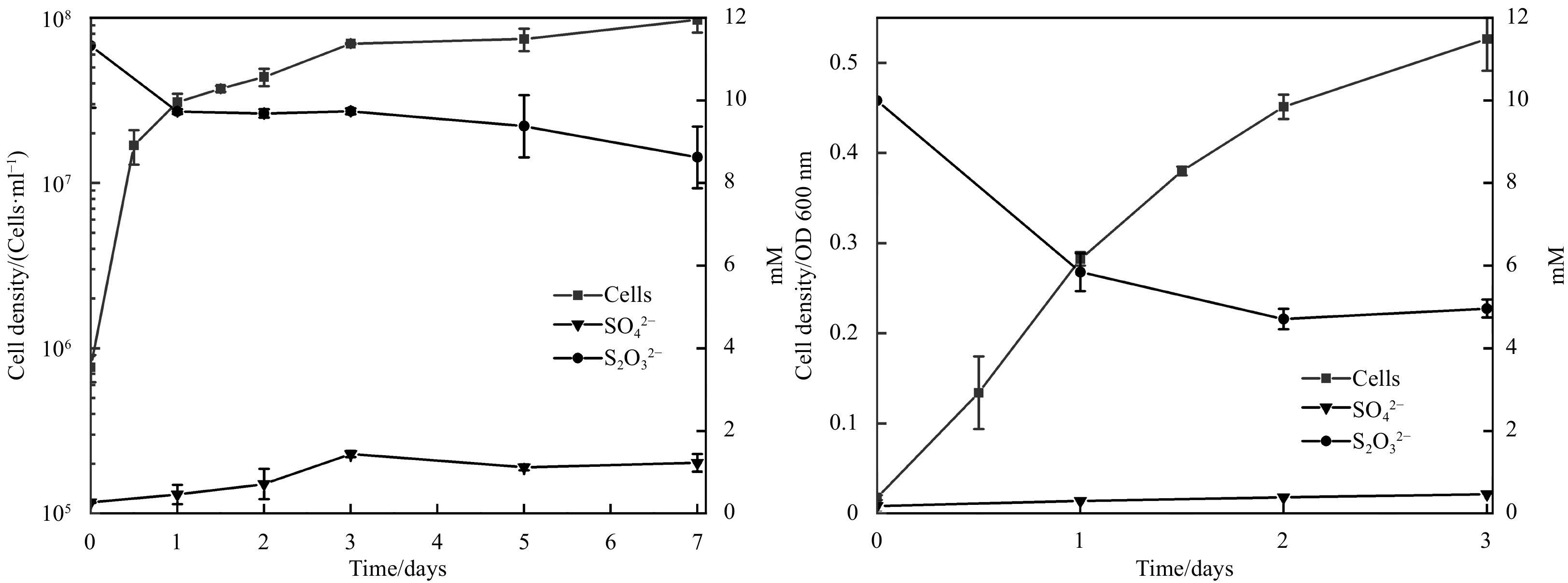


, Available online ,
doi: 10.1007/s13131-023-2243-1
Abstract:
Oxygen facilitates the breakdown of the organic material to provide energy for life. The concentration of dissolved oxygen (DO) in the water must exceed a certain threshold to support the normal metabolism of marine organisms. Located in the northern Beibu Gulf, Qinzhou Bay receives abundant freshwater and nutrients from several rivers which significantly influence the level ofthe dissolved oxygen. However, the spatial-temporal variations of DO as well as the associated driving mechanisms have been rarely studiedstudied through field observations. In this study, a three-dimensional coupled physical-biogeochemical model is used to investigate the spatial and seasonal variations of the DO and the associated driving mechanisms in Qinzhou Bay. The validation against observations indicates that the model can capture the seasonal and inter-annual variability of the DO concentration with the range of 5−10 mg·L−1. Sensitivity experiments show that the river discharges, winds and tides play crucial roles in the seasonal variability of the DO by changing the vertical mixing and stratification of the water column and the circulation pattern. In winter, the tide and wind forces have strong effects on the DO distribution by enhancing the vertical mixing, especially near the bay mouth. In summer, the river discharges play a dominant role in the DO distribution by inhibiting the vertical water exchange and delivering more nutrients to the Bay, which increases the DO depletion and results in lower DO on the bottom of the estuary salt wedge. These findings can contribute to the preservation and management of the coastal environment in the northern Beibu Gulf.
Oxygen facilitates the breakdown of the organic material to provide energy for life. The concentration of dissolved oxygen (DO) in the water must exceed a certain threshold to support the normal metabolism of marine organisms. Located in the northern Beibu Gulf, Qinzhou Bay receives abundant freshwater and nutrients from several rivers which significantly influence the level ofthe dissolved oxygen. However, the spatial-temporal variations of DO as well as the associated driving mechanisms have been rarely studiedstudied through field observations. In this study, a three-dimensional coupled physical-biogeochemical model is used to investigate the spatial and seasonal variations of the DO and the associated driving mechanisms in Qinzhou Bay. The validation against observations indicates that the model can capture the seasonal and inter-annual variability of the DO concentration with the range of 5−10 mg·L−1. Sensitivity experiments show that the river discharges, winds and tides play crucial roles in the seasonal variability of the DO by changing the vertical mixing and stratification of the water column and the circulation pattern. In winter, the tide and wind forces have strong effects on the DO distribution by enhancing the vertical mixing, especially near the bay mouth. In summer, the river discharges play a dominant role in the DO distribution by inhibiting the vertical water exchange and delivering more nutrients to the Bay, which increases the DO depletion and results in lower DO on the bottom of the estuary salt wedge. These findings can contribute to the preservation and management of the coastal environment in the northern Beibu Gulf.

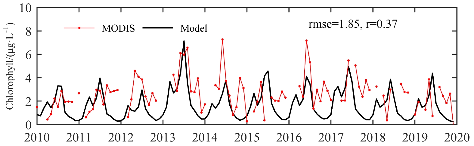

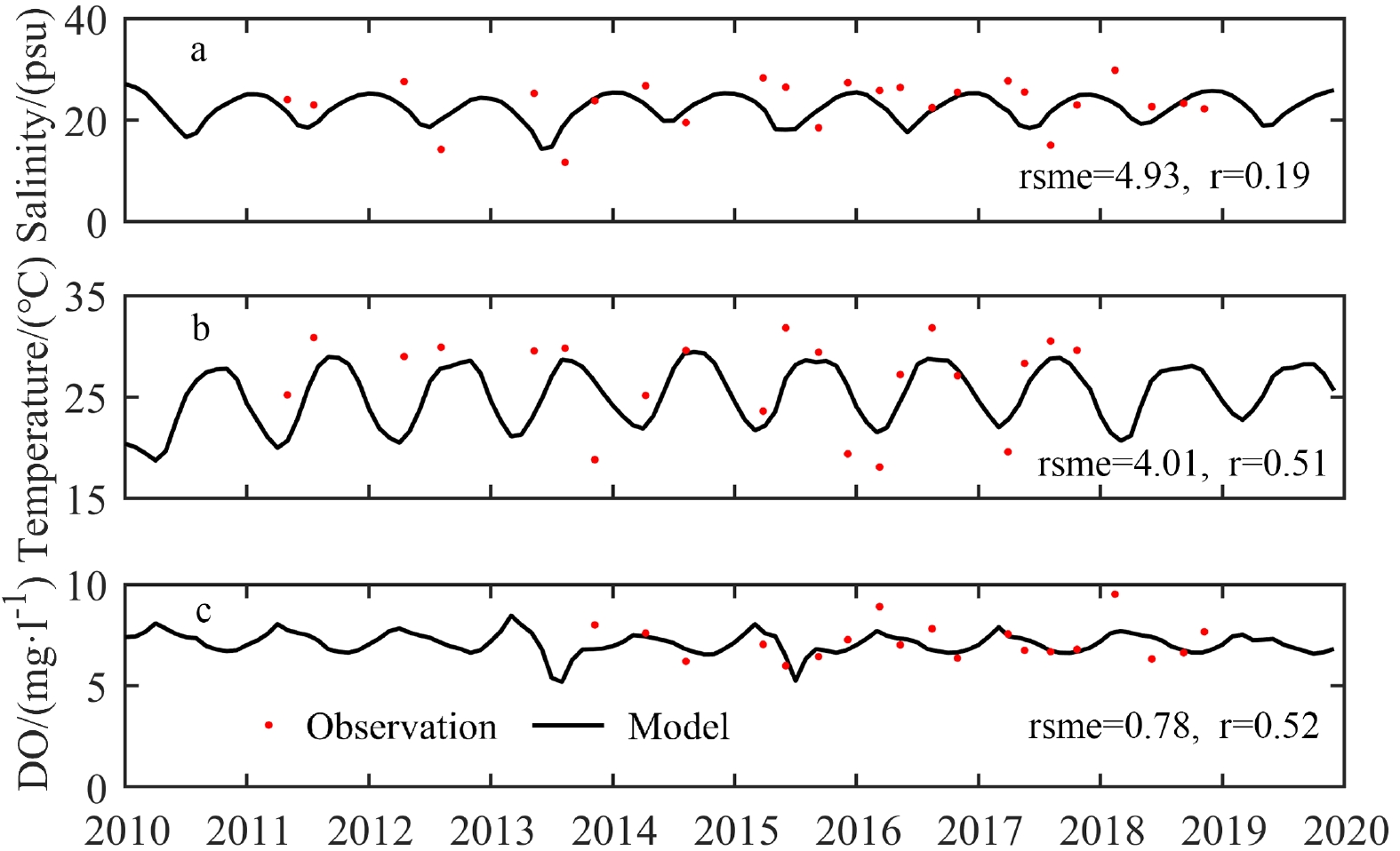
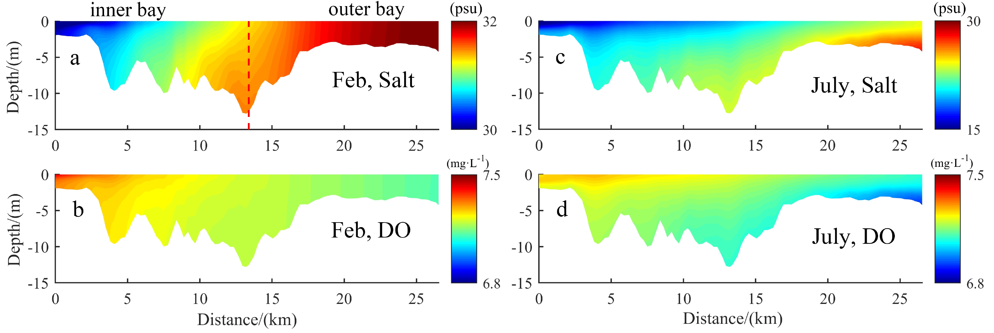


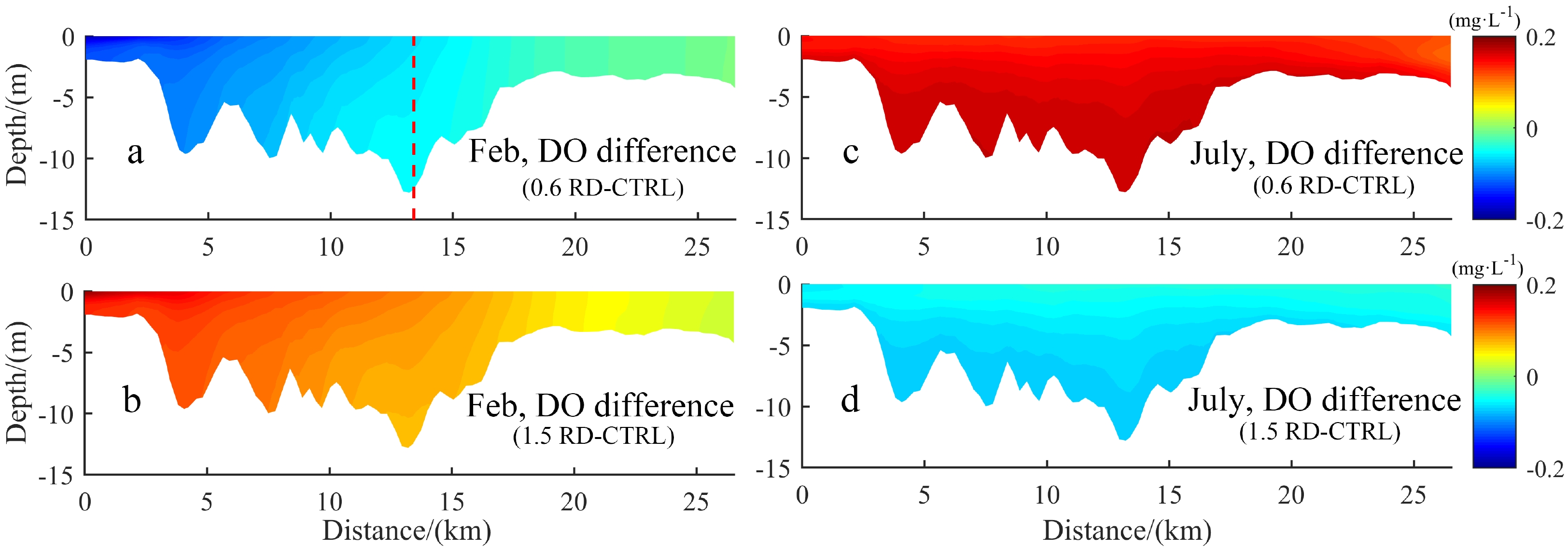
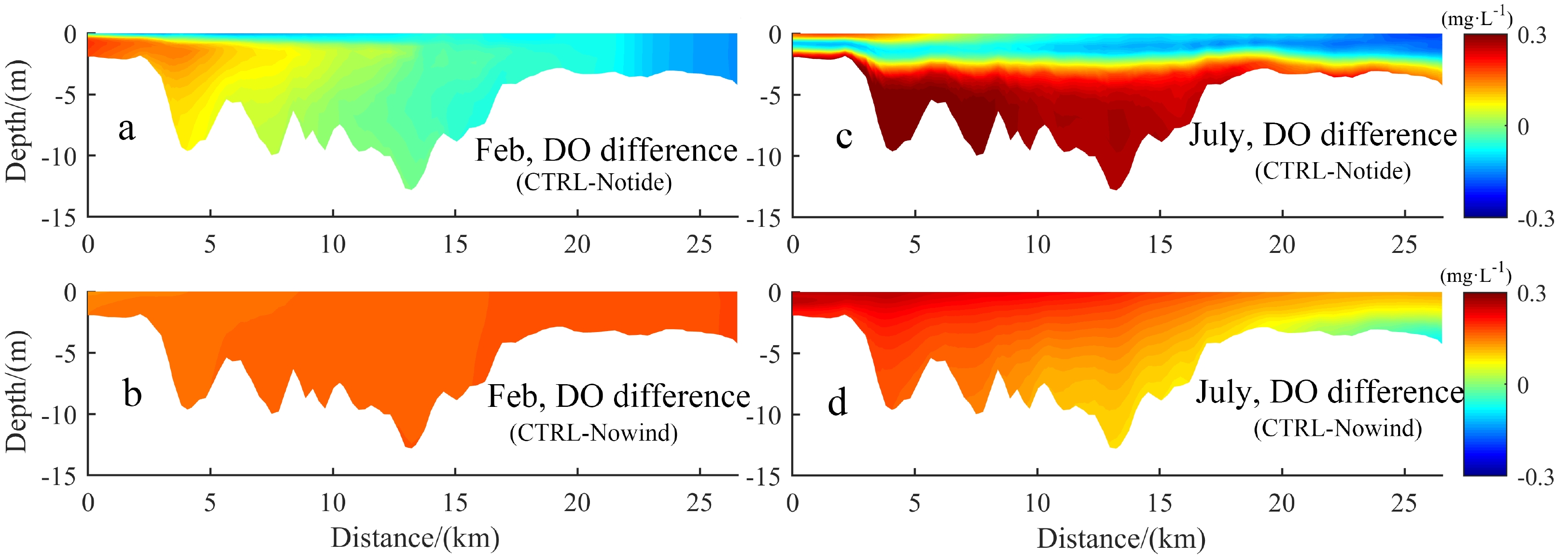

, Available online
Abstract:
This study aims at identifying the microevolutionary processes responsible for the onset of the remarkable phylogeographic structure already recorded for the endangered giant clam Tridacna squamosa across its distribution range. For this purpose, the evolutionary, biogeographic and demographic histories of the species were comprehensively reconstructed in a mitochondrial dataset comprising nearly the whole available published cytochrome c oxidase 1 gene sequences of T. squamosa. Relatively higher level of genetic diversification was unveiled within T. squamosa, in comparison to earlier macro-geographic investigations, whereby five mitochondrial clusters were delineated. The resulting divergent gene pools in the Red Sea, Western Indian Ocean, Indo-Malay Archipelago and Western Pacific were found to be driven by Early Pleistocene glacial vicariance events among refugial lineages. Accentuated genetic diversification of the species across the Indo-Malay Archipelago was successively triggered by historical dispersal event during the Mid-Pleistocene MIS19c interglacial. This latter historical event might have also enabled genetically distinct giant clams from the Indo-Malay Archipelago to subsequently colonize the Western Pacific, accounting for the genetic diversity hotspot detected within this region (comprising three divergent mitochondrial clusters). Late Pleistocene demographic expansion of T. squamosa, during the Last Interglacial period, could have contributed to forging spatial distribution of the so far delineated genetic entities across the Indo-Western Pacific. Overall, being resilient to major climate shifts during the Pleistocene through adaptation and consequent diversification, T. squamosa could be used as a model species to track the impact of climate change on genetic variability and structure of marine species. In particular, the new information, provided in this investigation, may help with understanding and/or predicting the consequences of ongoing global warming on genetic polymorphism of endangered coral reef species among which Tridacna sp. are listed as ecologically important.
This study aims at identifying the microevolutionary processes responsible for the onset of the remarkable phylogeographic structure already recorded for the endangered giant clam Tridacna squamosa across its distribution range. For this purpose, the evolutionary, biogeographic and demographic histories of the species were comprehensively reconstructed in a mitochondrial dataset comprising nearly the whole available published cytochrome c oxidase 1 gene sequences of T. squamosa. Relatively higher level of genetic diversification was unveiled within T. squamosa, in comparison to earlier macro-geographic investigations, whereby five mitochondrial clusters were delineated. The resulting divergent gene pools in the Red Sea, Western Indian Ocean, Indo-Malay Archipelago and Western Pacific were found to be driven by Early Pleistocene glacial vicariance events among refugial lineages. Accentuated genetic diversification of the species across the Indo-Malay Archipelago was successively triggered by historical dispersal event during the Mid-Pleistocene MIS19c interglacial. This latter historical event might have also enabled genetically distinct giant clams from the Indo-Malay Archipelago to subsequently colonize the Western Pacific, accounting for the genetic diversity hotspot detected within this region (comprising three divergent mitochondrial clusters). Late Pleistocene demographic expansion of T. squamosa, during the Last Interglacial period, could have contributed to forging spatial distribution of the so far delineated genetic entities across the Indo-Western Pacific. Overall, being resilient to major climate shifts during the Pleistocene through adaptation and consequent diversification, T. squamosa could be used as a model species to track the impact of climate change on genetic variability and structure of marine species. In particular, the new information, provided in this investigation, may help with understanding and/or predicting the consequences of ongoing global warming on genetic polymorphism of endangered coral reef species among which Tridacna sp. are listed as ecologically important.

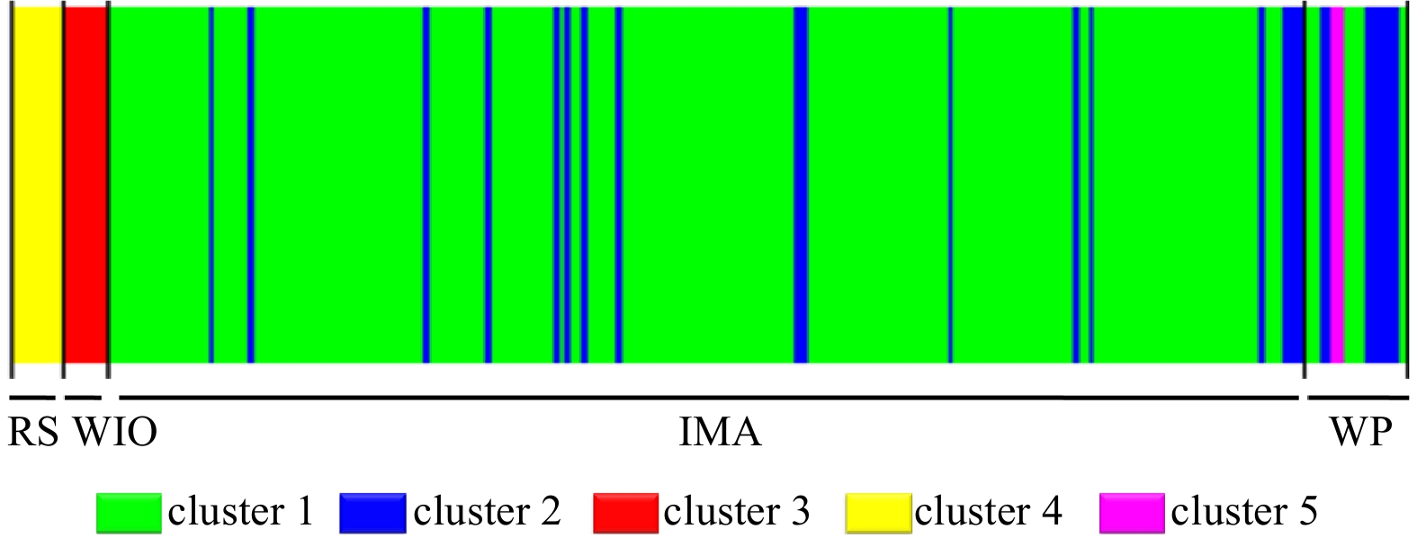
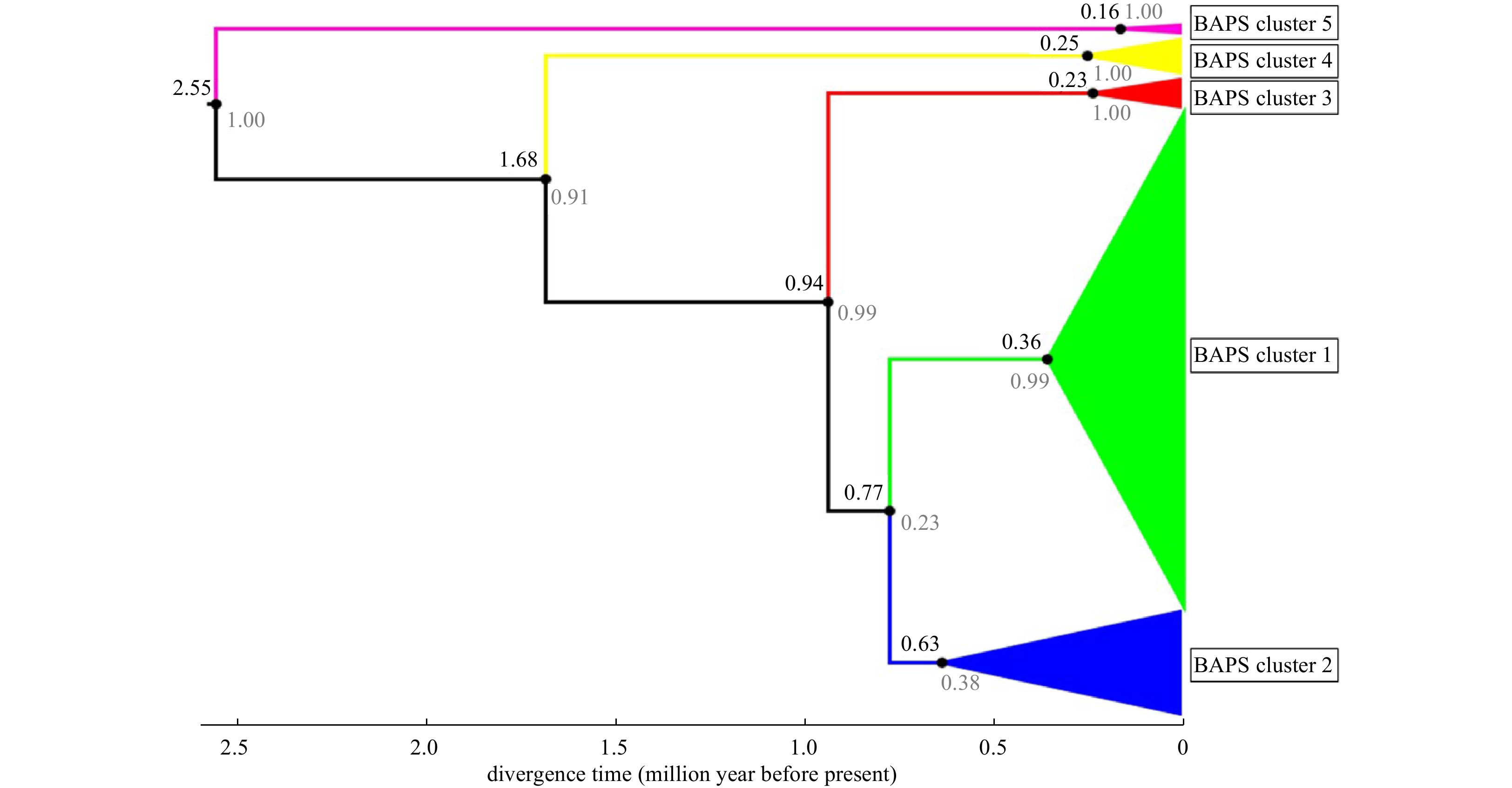
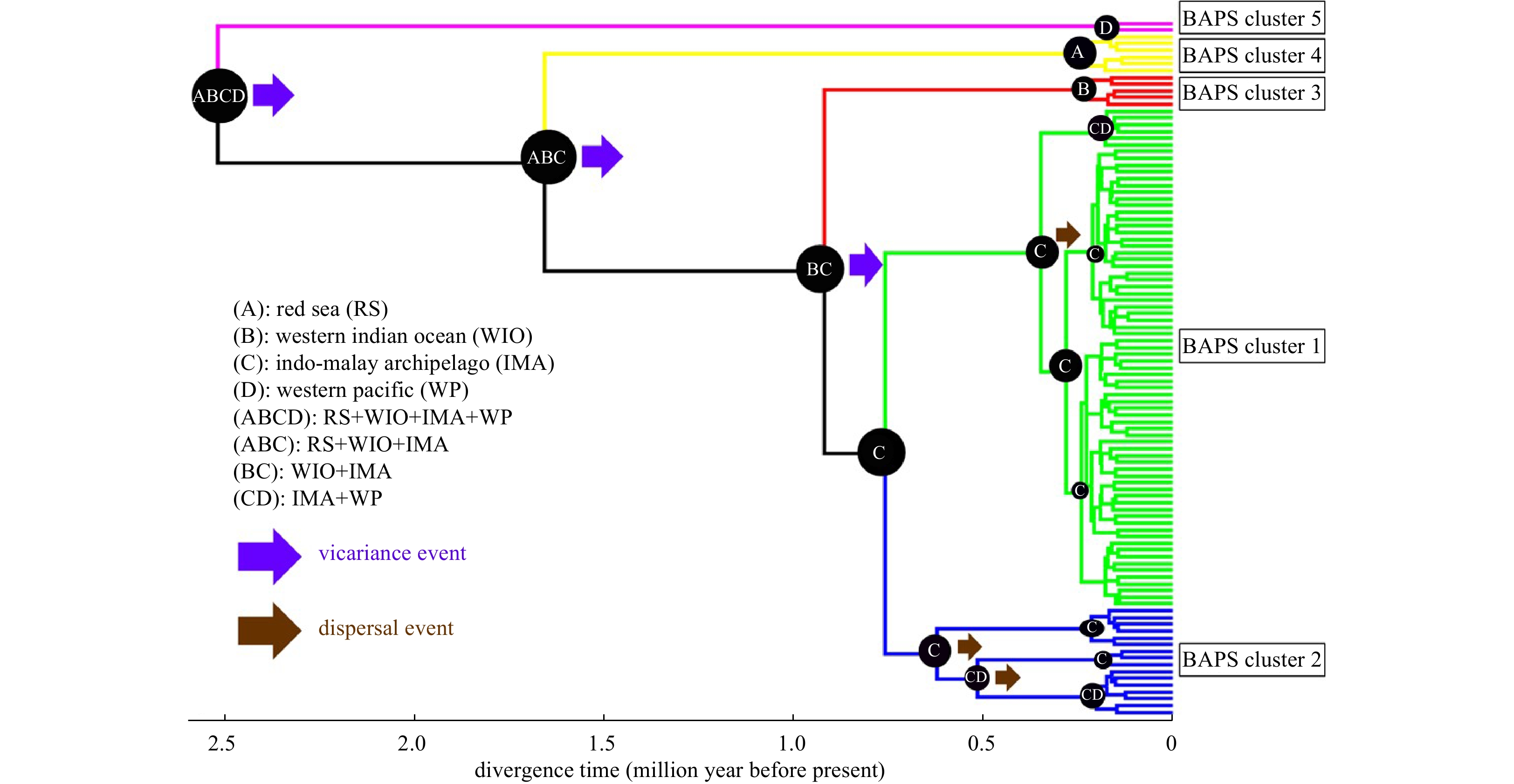

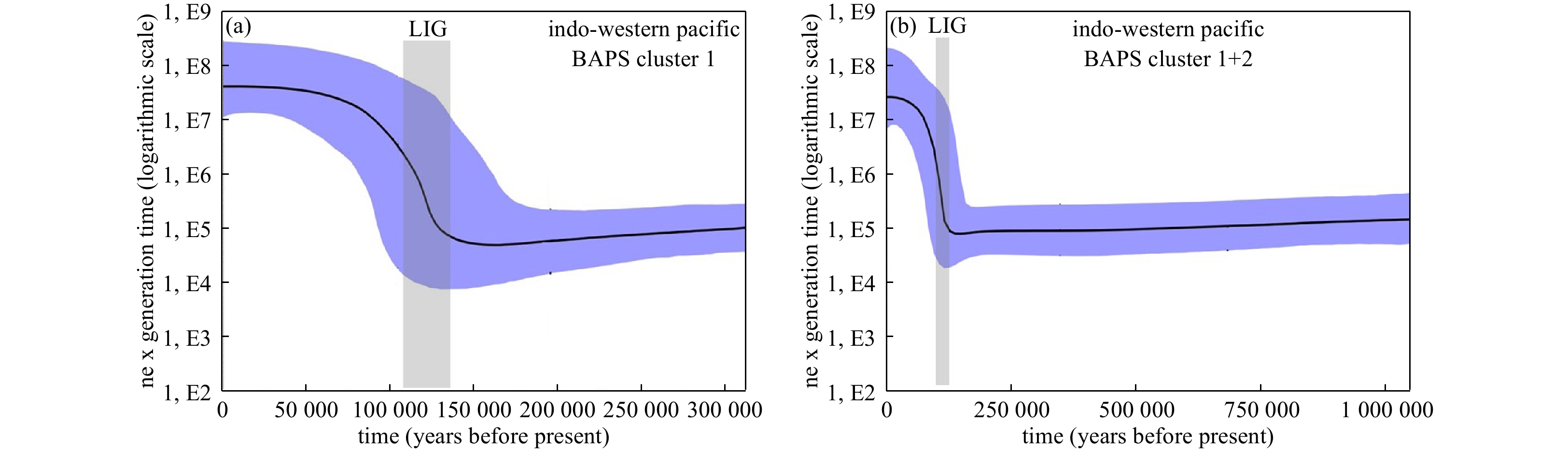

, Available online
Abstract:
Owing to the significant differences in environmental characteristics and explanatory factors among estuarine and coastal regions, research on diatom transfer functions and database establishment remains incomplete. This study analysed diatoms in surface sediment samples and a sediment core from the Lianjiang coast of the East China Sea, together with environmental variables. Principal component analysis of the environmental variables showed that sea surface salinity (SSS) and sea surface temperature were the most important factors controlling hydrological conditions in the Lianjiang coastal area, whereas canonical correspondence analysis indicated that SSS and pH were the main environmental factors affecting diatom distribution. Based on the modern diatom species–environmental variable database, we developed a diatom-based SSS transfer function to quantitatively reconstruct the variability in SSS between 1984 and 2021 for sediment core HK3 from the Lianjiang coastal area. The agreement between the reconstructed SSS and instrument SSS data from 1984–2021 suggests that diatom-based SSS reconstruction is reliable for studying past SSS variability in the Lianjiang coastal area. Three low SSS events in AD 2019, 2013, and 1999, together with an increased relative concentration of freshwater diatom species and coarser sediment grain sizes, corresponded to two super-typhoon events and a catastrophic flooding event in Lianjiang County. Thus, a diatom-based SSS transfer function for reconstructing past SSS variability in the estuarine and coastal areas of the East China Sea can be further used to reflect the paleoenvironmental events in this region.
Owing to the significant differences in environmental characteristics and explanatory factors among estuarine and coastal regions, research on diatom transfer functions and database establishment remains incomplete. This study analysed diatoms in surface sediment samples and a sediment core from the Lianjiang coast of the East China Sea, together with environmental variables. Principal component analysis of the environmental variables showed that sea surface salinity (SSS) and sea surface temperature were the most important factors controlling hydrological conditions in the Lianjiang coastal area, whereas canonical correspondence analysis indicated that SSS and pH were the main environmental factors affecting diatom distribution. Based on the modern diatom species–environmental variable database, we developed a diatom-based SSS transfer function to quantitatively reconstruct the variability in SSS between 1984 and 2021 for sediment core HK3 from the Lianjiang coastal area. The agreement between the reconstructed SSS and instrument SSS data from 1984–2021 suggests that diatom-based SSS reconstruction is reliable for studying past SSS variability in the Lianjiang coastal area. Three low SSS events in AD 2019, 2013, and 1999, together with an increased relative concentration of freshwater diatom species and coarser sediment grain sizes, corresponded to two super-typhoon events and a catastrophic flooding event in Lianjiang County. Thus, a diatom-based SSS transfer function for reconstructing past SSS variability in the estuarine and coastal areas of the East China Sea can be further used to reflect the paleoenvironmental events in this region.
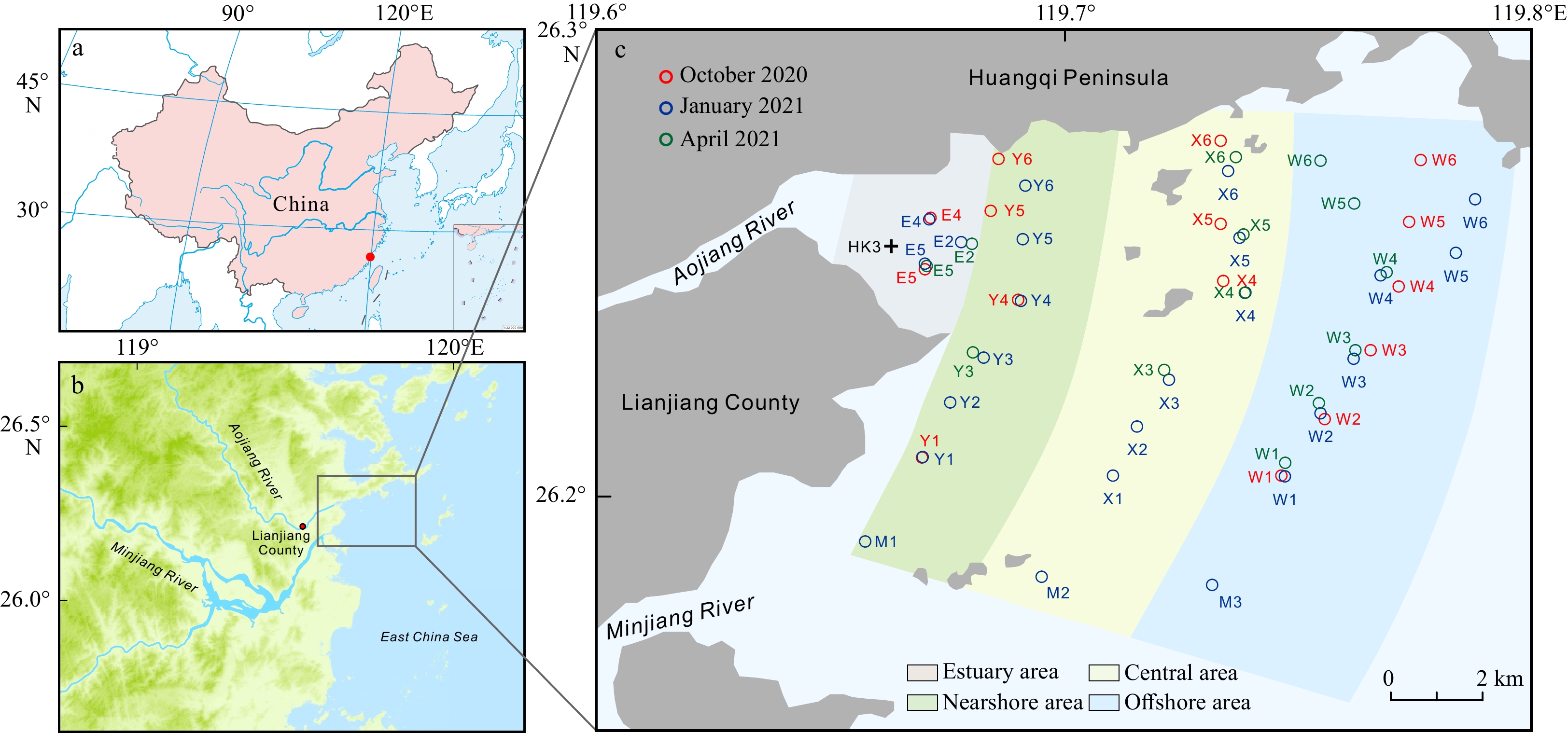
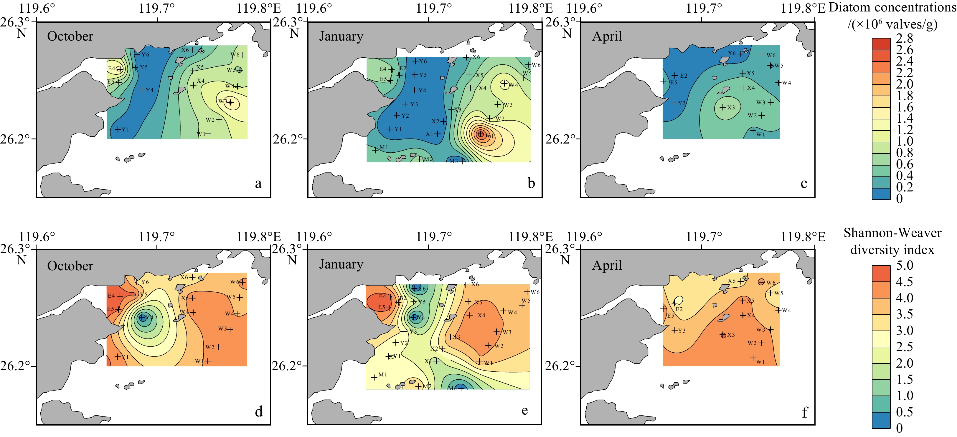
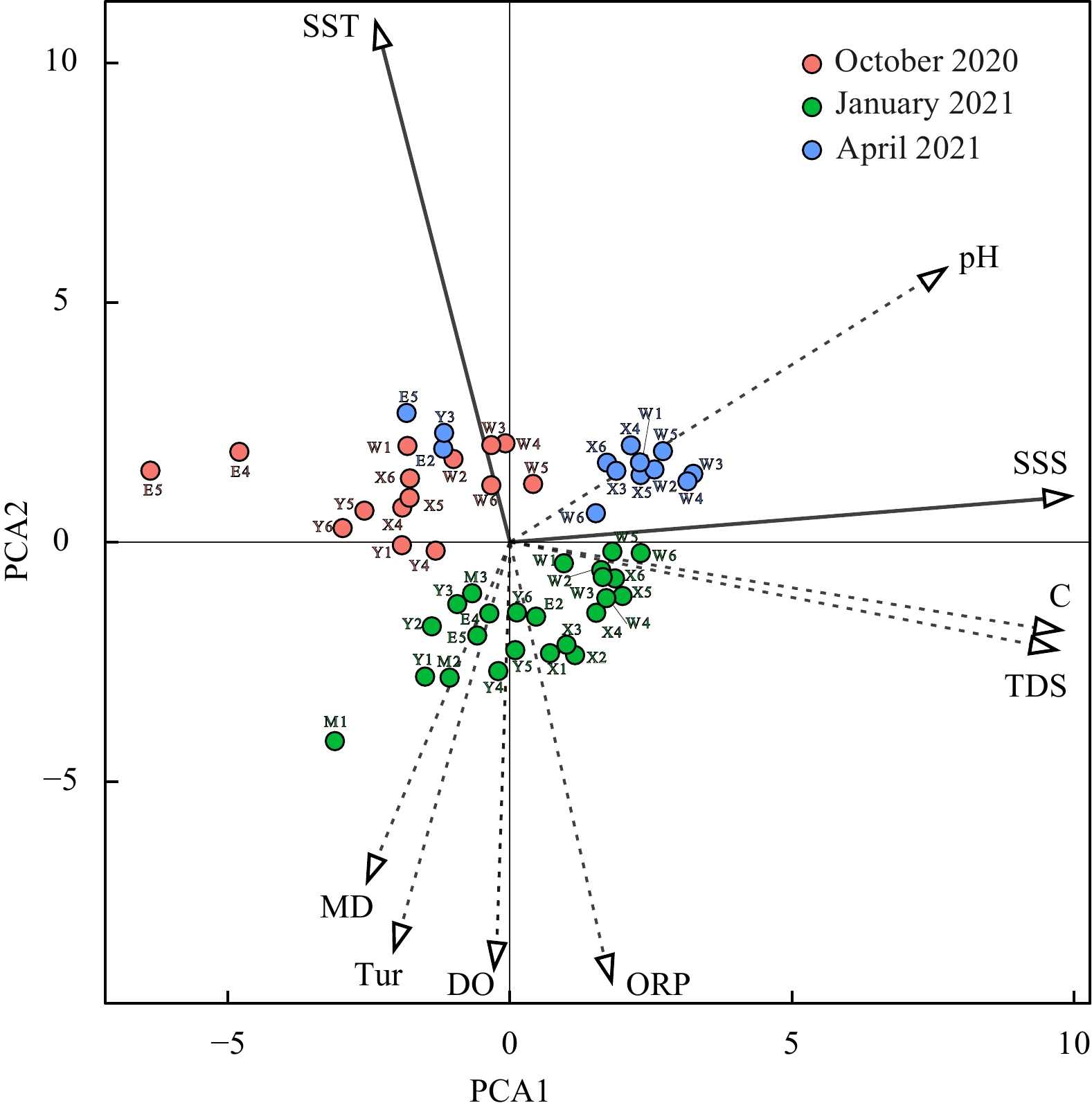

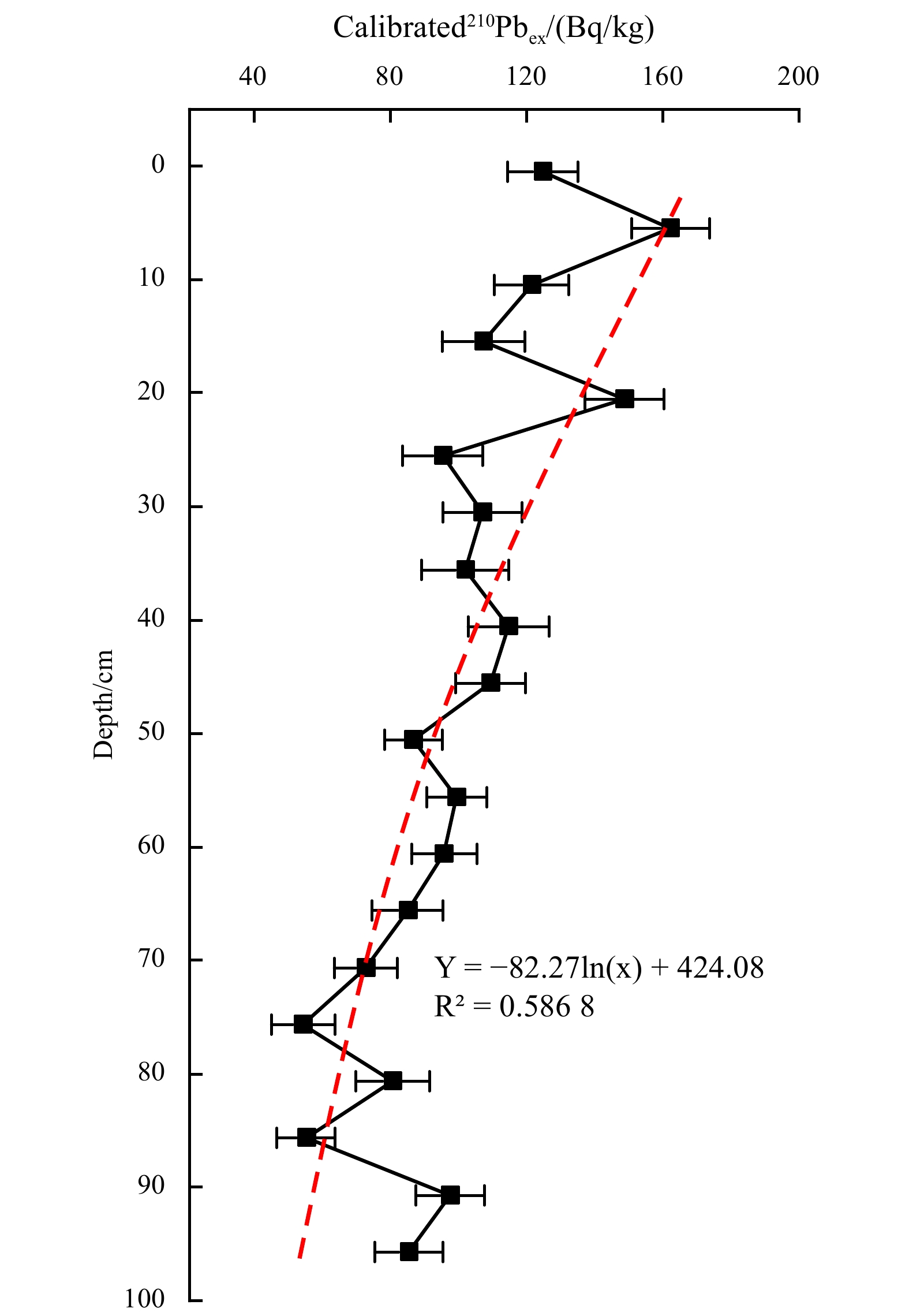
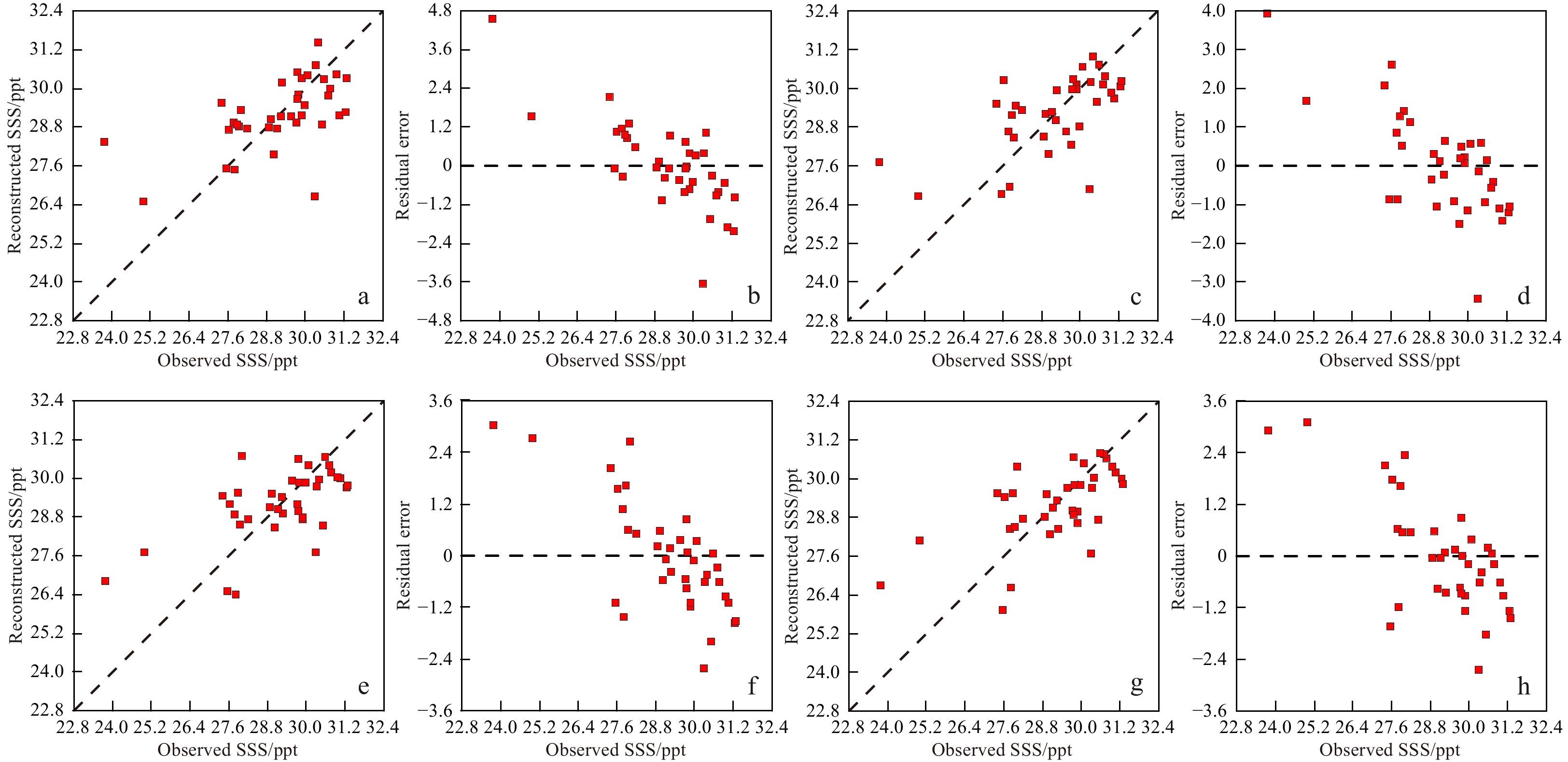

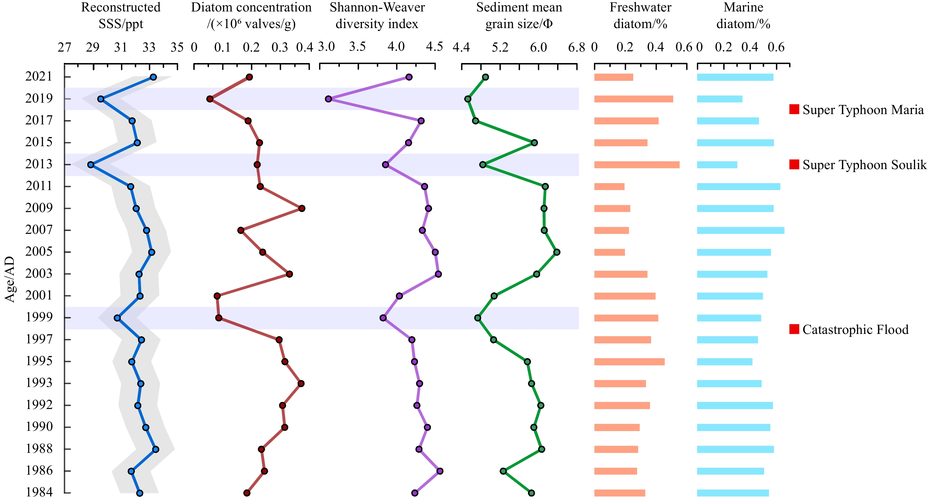
, Available online
Abstract:
The conventional theory of concerted evolution has been used to explain the lack of sequence variation in ribosomal RNA (rRNA) genes across diverse eukaryotic species. However, recent investigations into rRNA genes in flatfish genome have resulted in controversial findings. This study focuses on 18S rRNA genes of the widely distributed tongue sole, Cynoglossus abbreviatus (Pleuronectiformes: Cynoglossidae), aiming to explore sequence polymorphism. Five distinct 18S rDNA sequence types (Type A, B, R1, R2, and R3) were identified, suggesting a departure from concerted evolution. A combination of general criteria and variations in highly conserved regions were employed to detect pseudogenes. The results pinpointed Type A sequences as potential pseudogenes due to significant sequence variations and deviations in secondary structure within highly conserved regions. Three types (Type R1, R2, and R3) were identified as recombinants between Type A and B sequences, with simple crossing over and gene conversion as the most likely recombination mechanisms. These findings not only contribute to rRNA pseudogene identification but also shed light on the evolutionary dynamics of rRNA genes in teleost genomes.
The conventional theory of concerted evolution has been used to explain the lack of sequence variation in ribosomal RNA (rRNA) genes across diverse eukaryotic species. However, recent investigations into rRNA genes in flatfish genome have resulted in controversial findings. This study focuses on 18S rRNA genes of the widely distributed tongue sole, Cynoglossus abbreviatus (Pleuronectiformes: Cynoglossidae), aiming to explore sequence polymorphism. Five distinct 18S rDNA sequence types (Type A, B, R1, R2, and R3) were identified, suggesting a departure from concerted evolution. A combination of general criteria and variations in highly conserved regions were employed to detect pseudogenes. The results pinpointed Type A sequences as potential pseudogenes due to significant sequence variations and deviations in secondary structure within highly conserved regions. Three types (Type R1, R2, and R3) were identified as recombinants between Type A and B sequences, with simple crossing over and gene conversion as the most likely recombination mechanisms. These findings not only contribute to rRNA pseudogene identification but also shed light on the evolutionary dynamics of rRNA genes in teleost genomes.


, Available online ,
doi: 10.1007/s13131-023-2217-3
Abstract:
Isopod crustaceans of the family Dajidae are exclusively marine ectoparasites. The genus NotophryxusG. O. Sars, 1883 currently includes nine nominal species, which are very rarely reported as the chances for encountering these specimens are unpredictable. Our comprehension of the taxonomy, biology, ecology, and life cycle of species belonging to the Notophryxus genus is notably lacking. All nominal species of Notophryxus genus are reviewed here to obtain a comprehensive and integrative taxonomic understanding of this genus, in an attempt to address the lacunae. This paper also documents the rediscovery of an ectoparasitic isopod from the genus Notophryxus in Indian waters, after 55 years. Adult isopod specimens obtained from the outer reefs of Amini Island in the Lakshadweep archipelago, Southeastern Arabian Sea, display morphological congruence to Notophryxus globularis G.O. Sars, 1885 . The only previous report on this species dates back to 1885 from G.O. Sars' description of N. globularis as an ectoparasite on the euphausiid Thysanoessa gregaria G.O. Sars, 1883 in the North Pacific. This discovery represents a range extension of N. globularis from the North Pacific to the Arabian Sea. Two cryptoniscid larvae and three adult females of N. globularis (with dwarf males) were found attached to four adult mysid specimens of Siriella aequiremis Hansen, 1910 . The present study provides an improved diagnosis of N. globularis with the aid of light microscopy images and line drawings which was not given in the original G O Sars, 1885 report. This research also provides a concise description of cryptoniscid larvae from the same sampling location and same host which is most likely to be N. globularis larvae.
Isopod crustaceans of the family Dajidae are exclusively marine ectoparasites. The genus Notophryxus

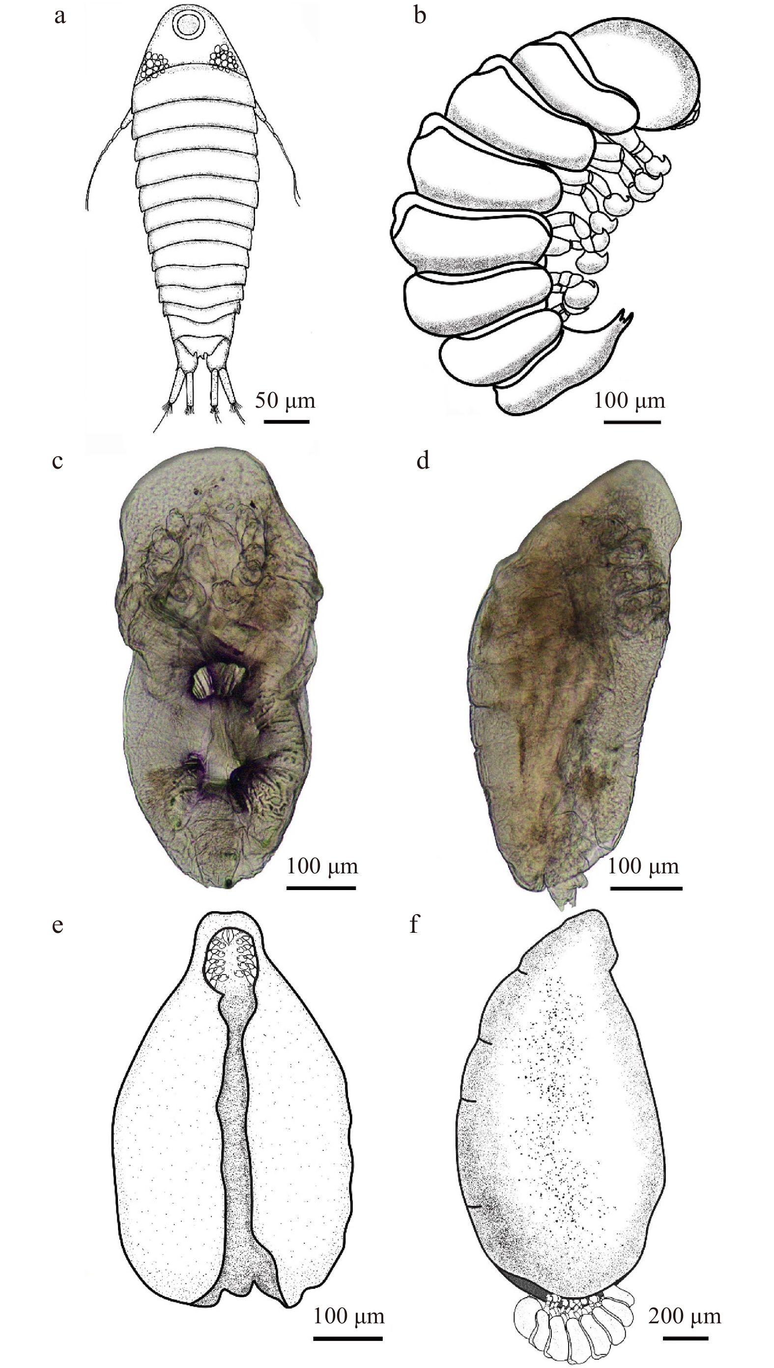
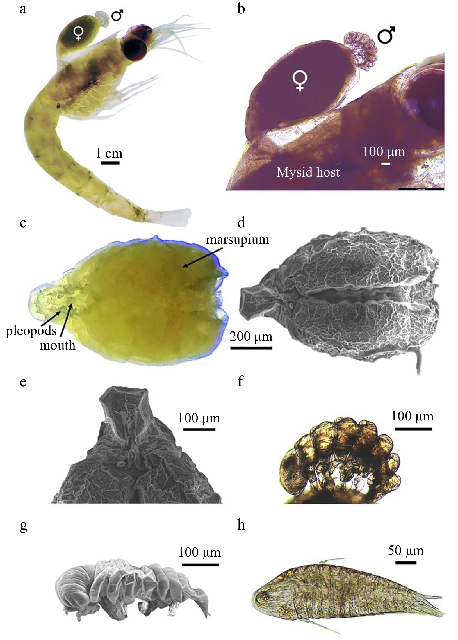
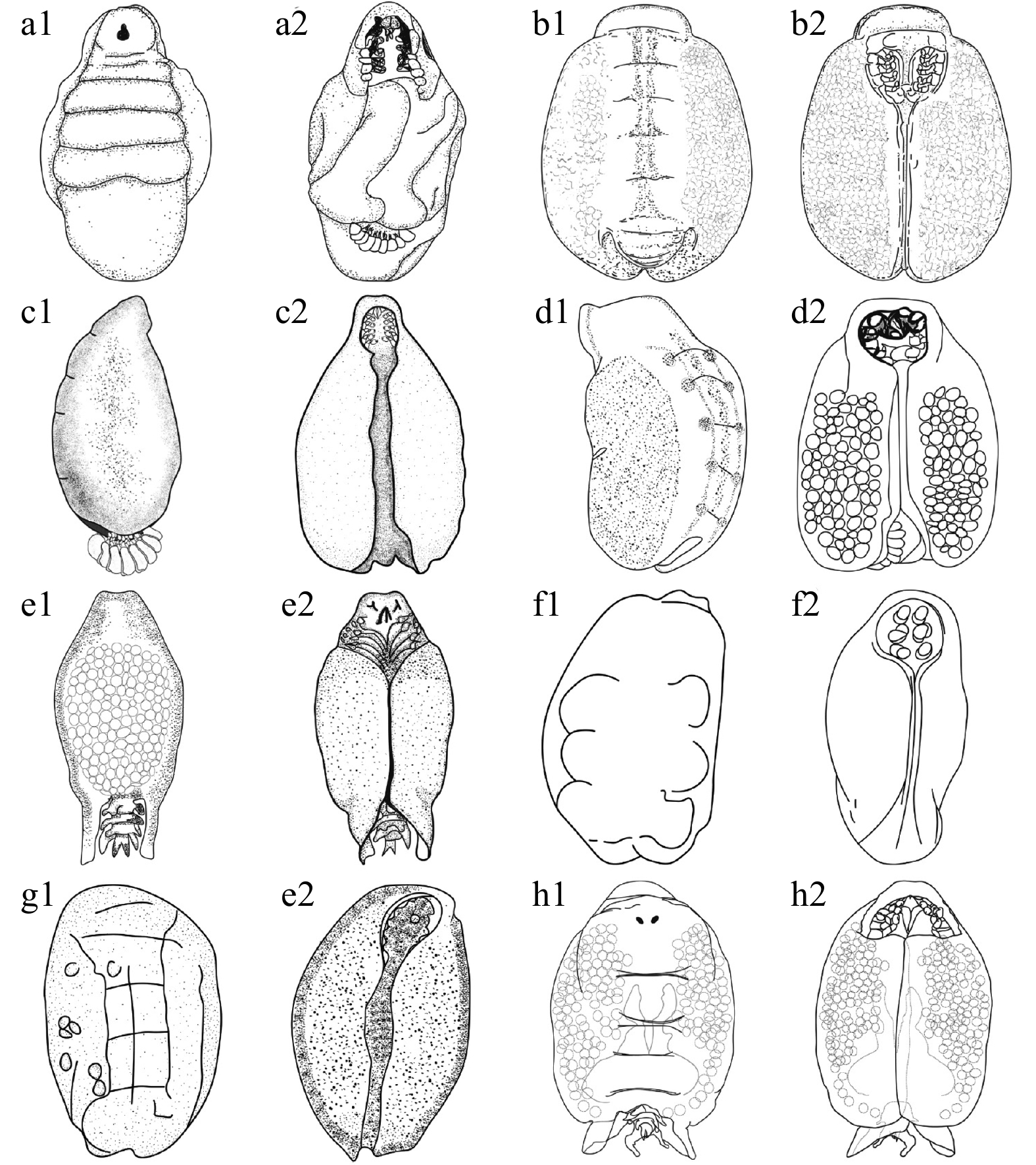
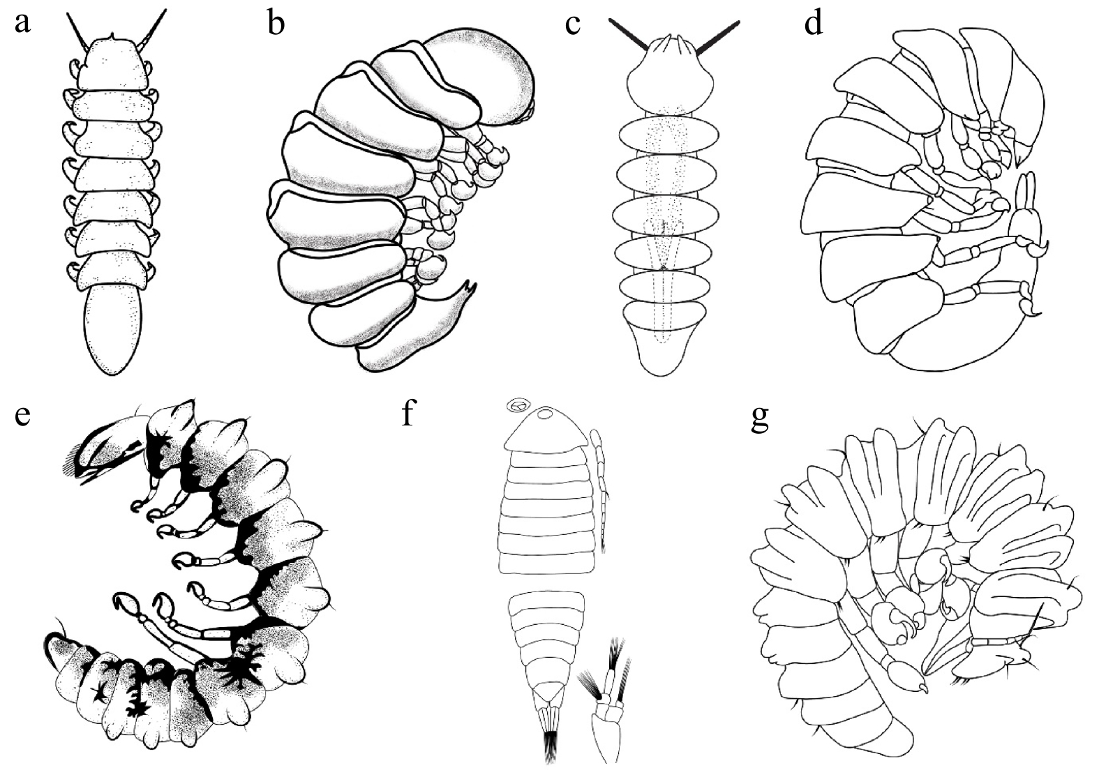
, Available online ,
doi: 10.1007/s13131-023-2254-y
Abstract:
Ocean productivity is the foundation of the marine food web, which continuously removes atmospheric carbon dioxide and supports life at sea and on land. Spatio-temporal variability of net primary productivity (NPP), sea surface temperature (SST), sea surface salinity (SSS), mixed layer depth (MLD), and euphotic zone depth (EZD) in the northern Bay of Bengal (BoB) during the three monsoon seasons were examined in this study based on remote sensing data for the period 2005 to 2020. To compare the NPP distribution between the coastal zones and open BoB, the study area was divided into five zones (Z1-Z5). The results suggest that the most productive Z2 and Z1 are located at the head bay area and are directly influenced by freshwater discharge together with riverine sediment and nutrient loads. Across Z1-Z5, the NPP ranges from 5315.38 mg/(m2·d) to 346.7 mg/(m2·d) (in terms of carbon, since then the same). The highest monthly average NPP of 5315.38 mg/(m2·d) in February and 5039.36 mg/(m2·d) in June were observed from Z2, while the lowest monthly average of 346.72 mg/(m2·d) was observed in March from Z4, which is an oceanic zone. EZD values vary from 6-154 m for the study area, and it has an inverse correlation with NPP concentration. EZD is deeper during the summer season and shallower during the wintertime, with a corresponding increase in productivity. Throughout the year, monthly SST shows slight fluctuation for the entire study area, and statistical analysis showed a significant correlation among NPP, and EZD, overall positive between NPP and MLD, whereas no significant correlation among SSS, and SST for the northern Bay of Bengal. Long-term trends in SST and productivity were significantly positive in head bay zones but negatively productive in the open ocean. The findings in this study on the distribution of NPP, SST, SSS, MLD, and EZD and their seasonal variability in five different zones of BoB can be used to further improve the management of marine resources and overall environmental conditional in response to climate changes in the BoB as they are of utmost relevance to the fisheries for the three bordering countries.
Ocean productivity is the foundation of the marine food web, which continuously removes atmospheric carbon dioxide and supports life at sea and on land. Spatio-temporal variability of net primary productivity (NPP), sea surface temperature (SST), sea surface salinity (SSS), mixed layer depth (MLD), and euphotic zone depth (EZD) in the northern Bay of Bengal (BoB) during the three monsoon seasons were examined in this study based on remote sensing data for the period 2005 to 2020. To compare the NPP distribution between the coastal zones and open BoB, the study area was divided into five zones (Z1-Z5). The results suggest that the most productive Z2 and Z1 are located at the head bay area and are directly influenced by freshwater discharge together with riverine sediment and nutrient loads. Across Z1-Z5, the NPP ranges from 5315.38 mg/(m2·d) to 346.7 mg/(m2·d) (in terms of carbon, since then the same). The highest monthly average NPP of 5315.38 mg/(m2·d) in February and 5039.36 mg/(m2·d) in June were observed from Z2, while the lowest monthly average of 346.72 mg/(m2·d) was observed in March from Z4, which is an oceanic zone. EZD values vary from 6-154 m for the study area, and it has an inverse correlation with NPP concentration. EZD is deeper during the summer season and shallower during the wintertime, with a corresponding increase in productivity. Throughout the year, monthly SST shows slight fluctuation for the entire study area, and statistical analysis showed a significant correlation among NPP, and EZD, overall positive between NPP and MLD, whereas no significant correlation among SSS, and SST for the northern Bay of Bengal. Long-term trends in SST and productivity were significantly positive in head bay zones but negatively productive in the open ocean. The findings in this study on the distribution of NPP, SST, SSS, MLD, and EZD and their seasonal variability in five different zones of BoB can be used to further improve the management of marine resources and overall environmental conditional in response to climate changes in the BoB as they are of utmost relevance to the fisheries for the three bordering countries.
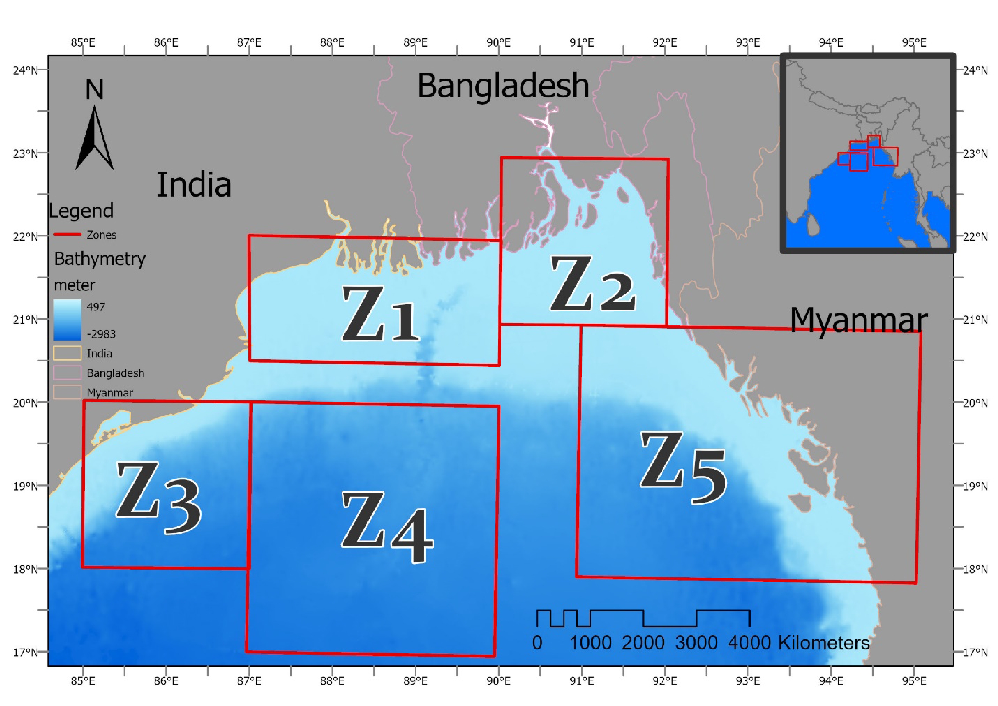


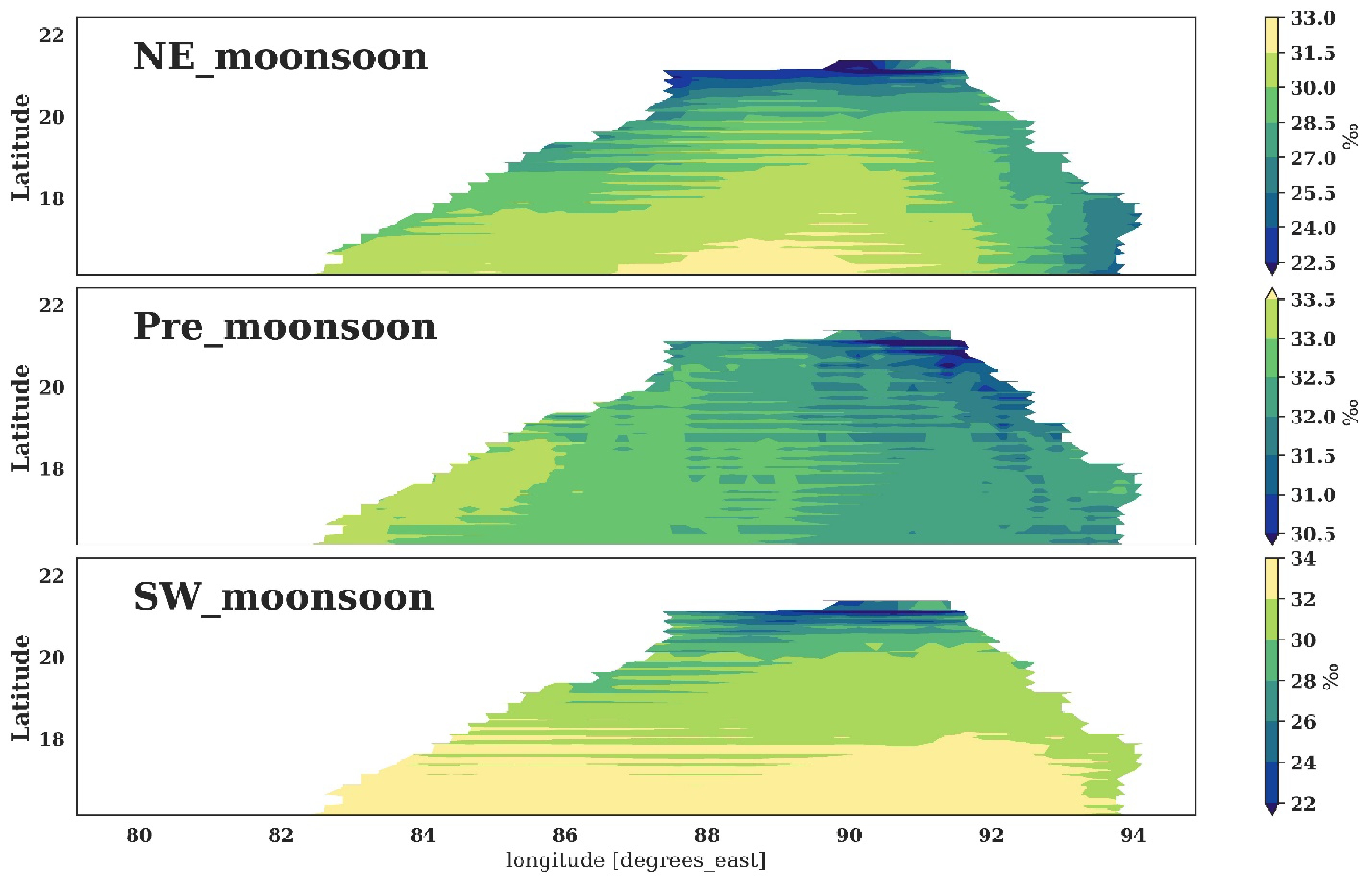
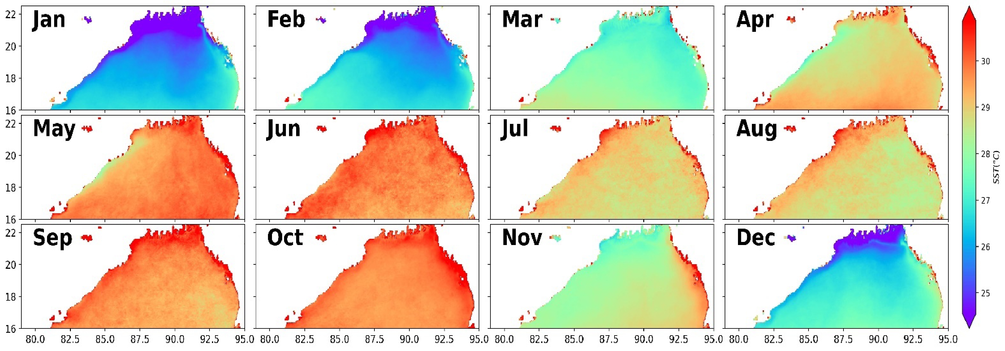

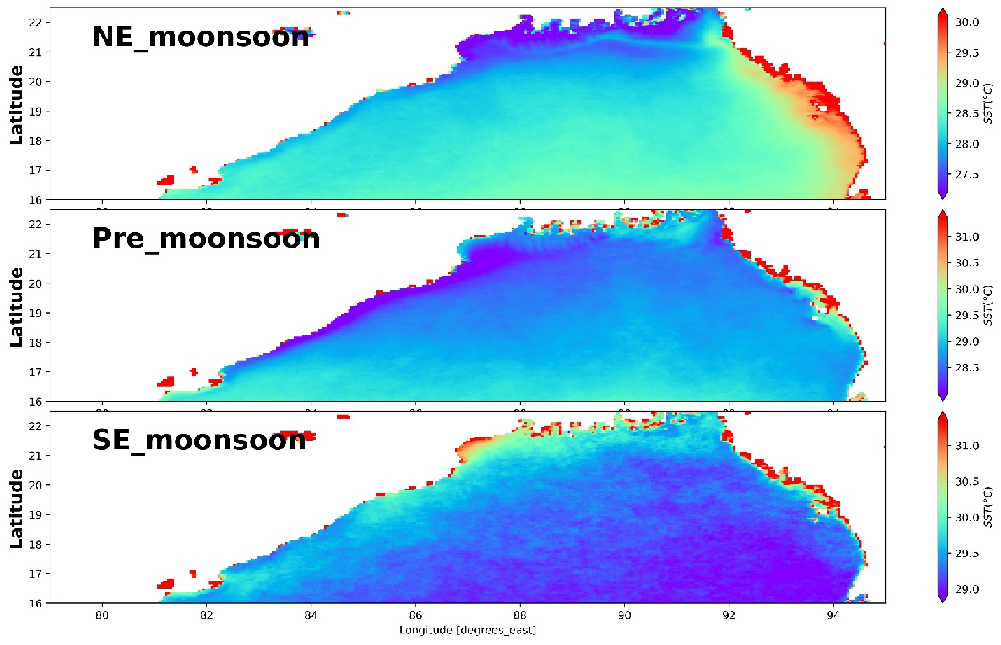
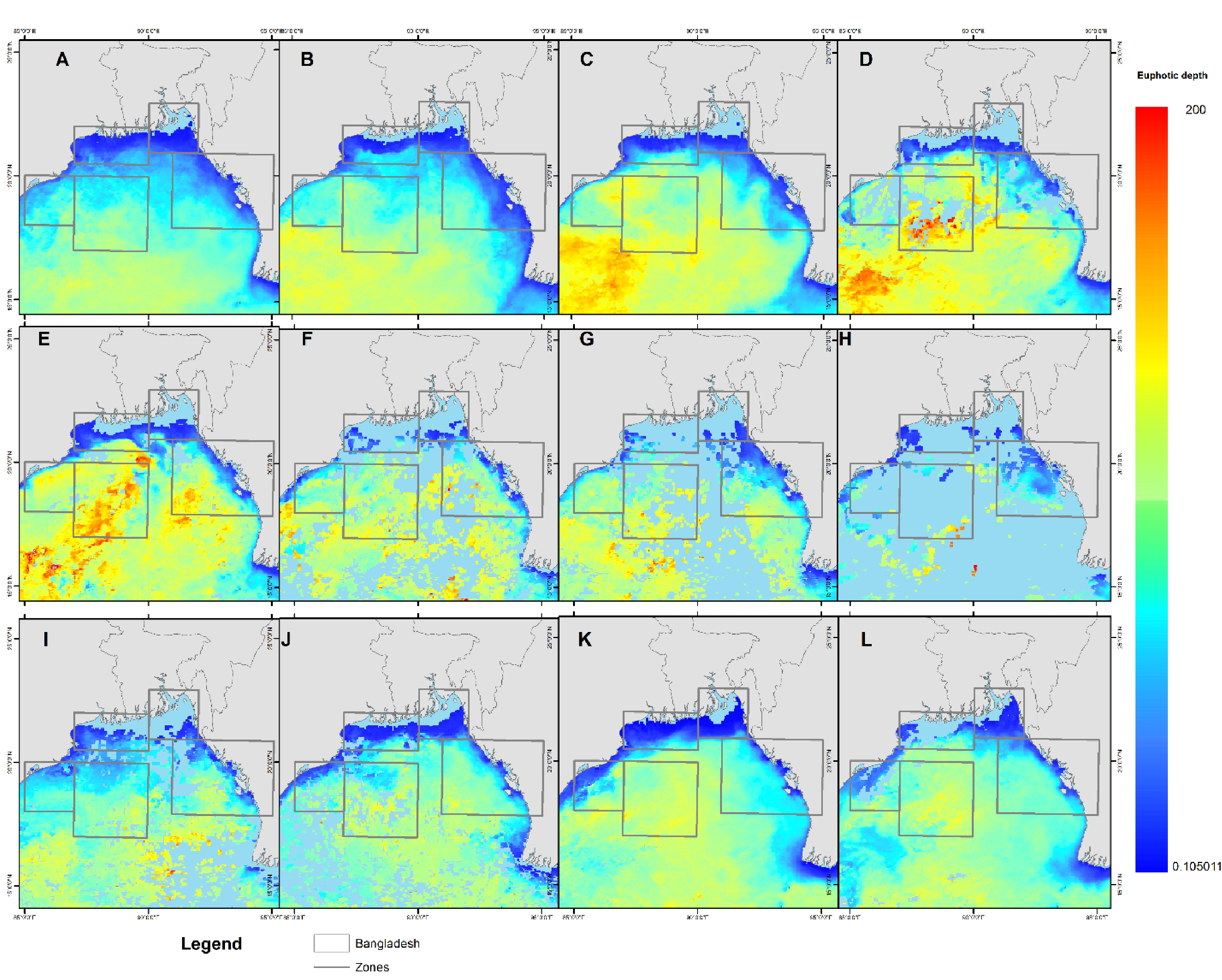
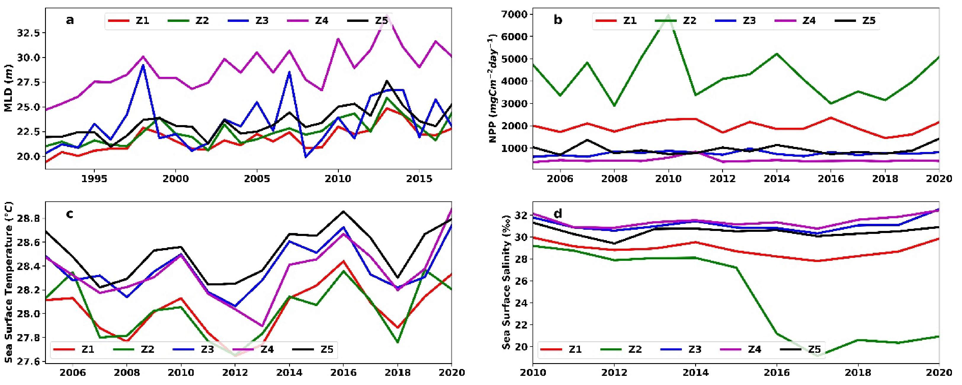
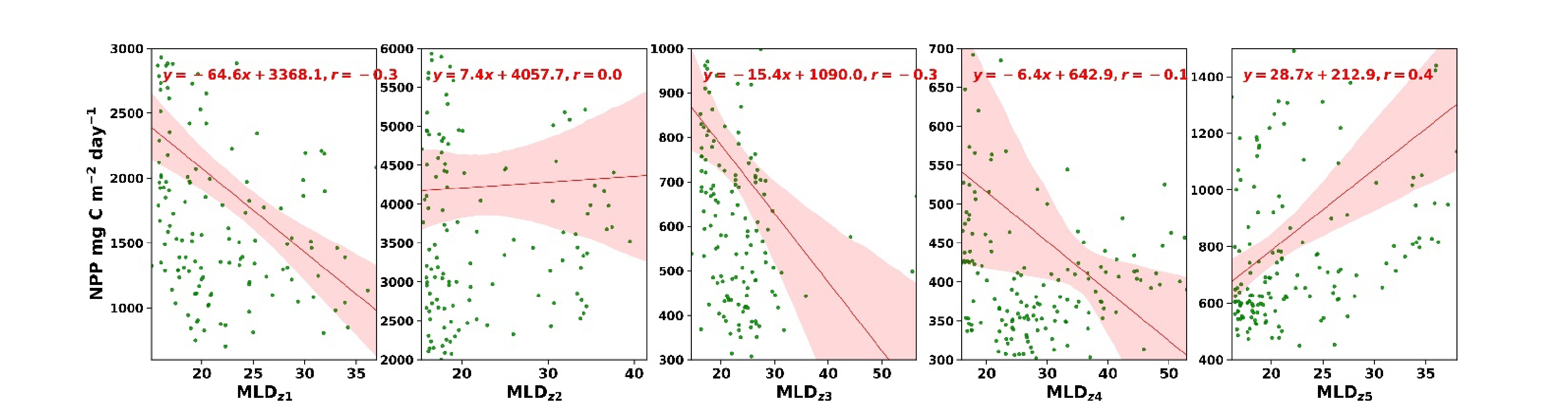
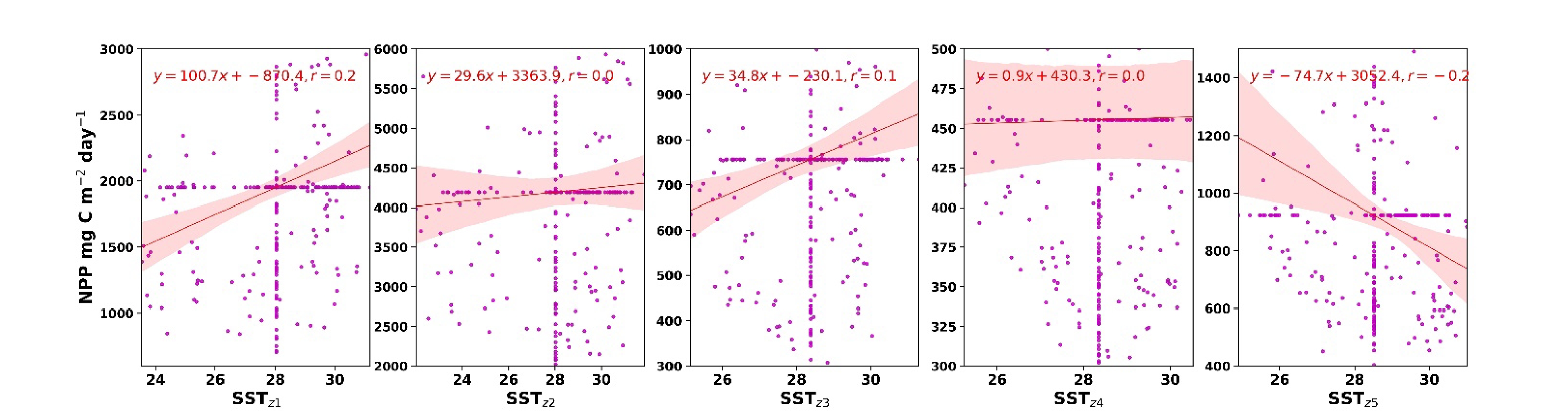

, Available online ,
doi: 10.1007/s13131-023-2244-0
Abstract:
Hypoxia off the Changjiang River Estuary has been the subject of much attention, yet systematic observations have been lacking, resulting in a lack of knowledge regarding its long-term change and drivers. By revisiting the repeated surveys of dissolved oxygen (DO) and other relevant hydrographic parameters along the section from the Changjiang River Estuary to the Cheju Island in the summer from 1997 to 2014, rather different trends were revealed for the dual low-DO cores. The nearshore low-DO core, located close to the river mouth and relatively stable, shows that hypoxia has become more severe with the lowest DO descending at a rate of −0.07 mg/(L·a) and the thickness of low-DO zone rising at a rate of 0.43 m/a. The offshore core, centered around 40-m isobath but moving back and forth between 123.5°–125°E, shows large fluctuations in the minimum DO concentration, with the thickness of low-DO zone falling at a rate of −1.55 m/a. The probable factors affecting the minimum DO concentration in the two regions also vary. In the nearshore region, the decreasing minimum DO is driven by the increase in both stratification and primary productivity, with the enhanced extension of the Changjiang River Diluted Water (CDW) strengthening stratification. In the offshore region, the fluctuating trend of the minimum DO concentration indicates that both DO loss and DO supplement are distinct. The DO loss is primarily attributed to bottom apparent oxygen utilization caused by the organic matter decay and is also relevant to the advection of low-DO water from the nearshore region. The DO supplement is primarily due to weakened stratification. Our analysis also shows that the minimum DO concentration in the nearshore region was extremely low in 1998, 2003, 2007 and 2010, related to El Niño signal in these summers.
Hypoxia off the Changjiang River Estuary has been the subject of much attention, yet systematic observations have been lacking, resulting in a lack of knowledge regarding its long-term change and drivers. By revisiting the repeated surveys of dissolved oxygen (DO) and other relevant hydrographic parameters along the section from the Changjiang River Estuary to the Cheju Island in the summer from 1997 to 2014, rather different trends were revealed for the dual low-DO cores. The nearshore low-DO core, located close to the river mouth and relatively stable, shows that hypoxia has become more severe with the lowest DO descending at a rate of −0.07 mg/(L·a) and the thickness of low-DO zone rising at a rate of 0.43 m/a. The offshore core, centered around 40-m isobath but moving back and forth between 123.5°–125°E, shows large fluctuations in the minimum DO concentration, with the thickness of low-DO zone falling at a rate of −1.55 m/a. The probable factors affecting the minimum DO concentration in the two regions also vary. In the nearshore region, the decreasing minimum DO is driven by the increase in both stratification and primary productivity, with the enhanced extension of the Changjiang River Diluted Water (CDW) strengthening stratification. In the offshore region, the fluctuating trend of the minimum DO concentration indicates that both DO loss and DO supplement are distinct. The DO loss is primarily attributed to bottom apparent oxygen utilization caused by the organic matter decay and is also relevant to the advection of low-DO water from the nearshore region. The DO supplement is primarily due to weakened stratification. Our analysis also shows that the minimum DO concentration in the nearshore region was extremely low in 1998, 2003, 2007 and 2010, related to El Niño signal in these summers.
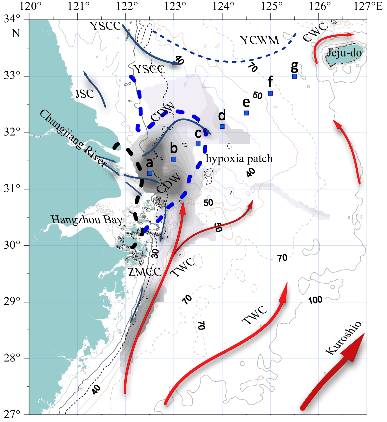
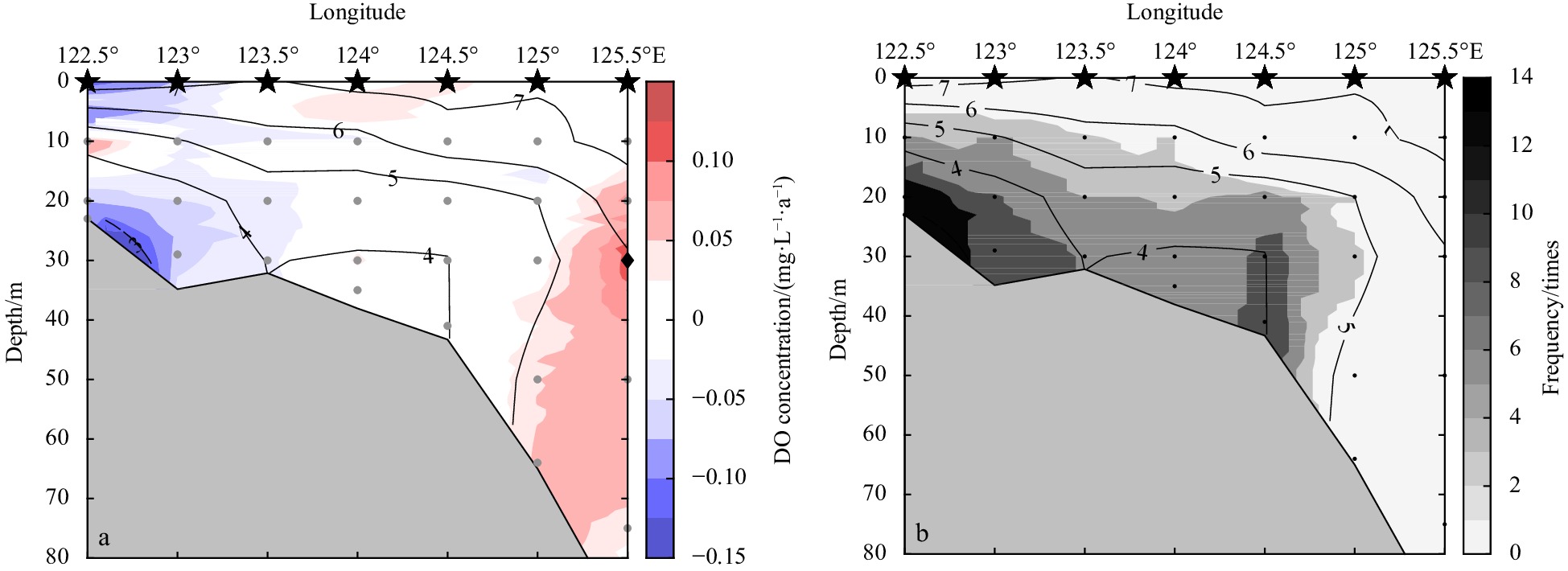

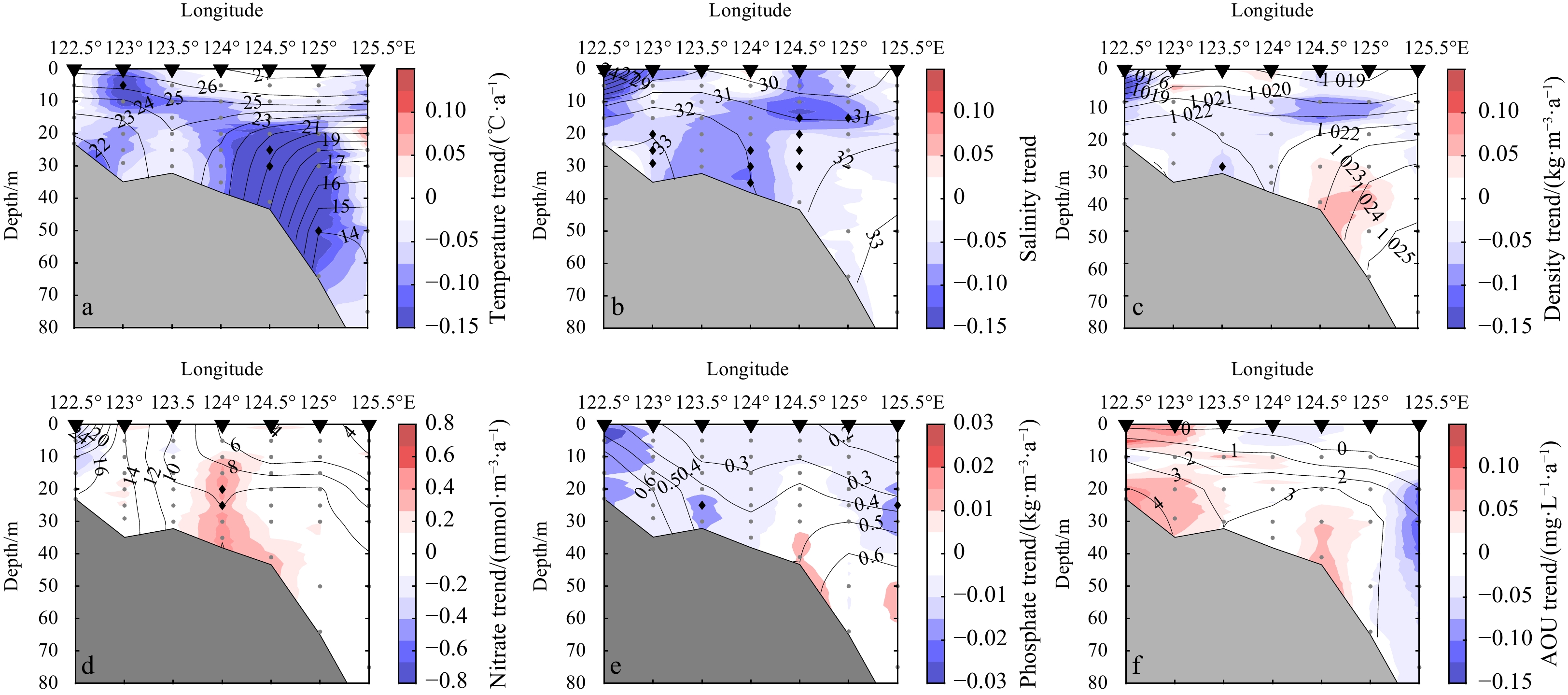
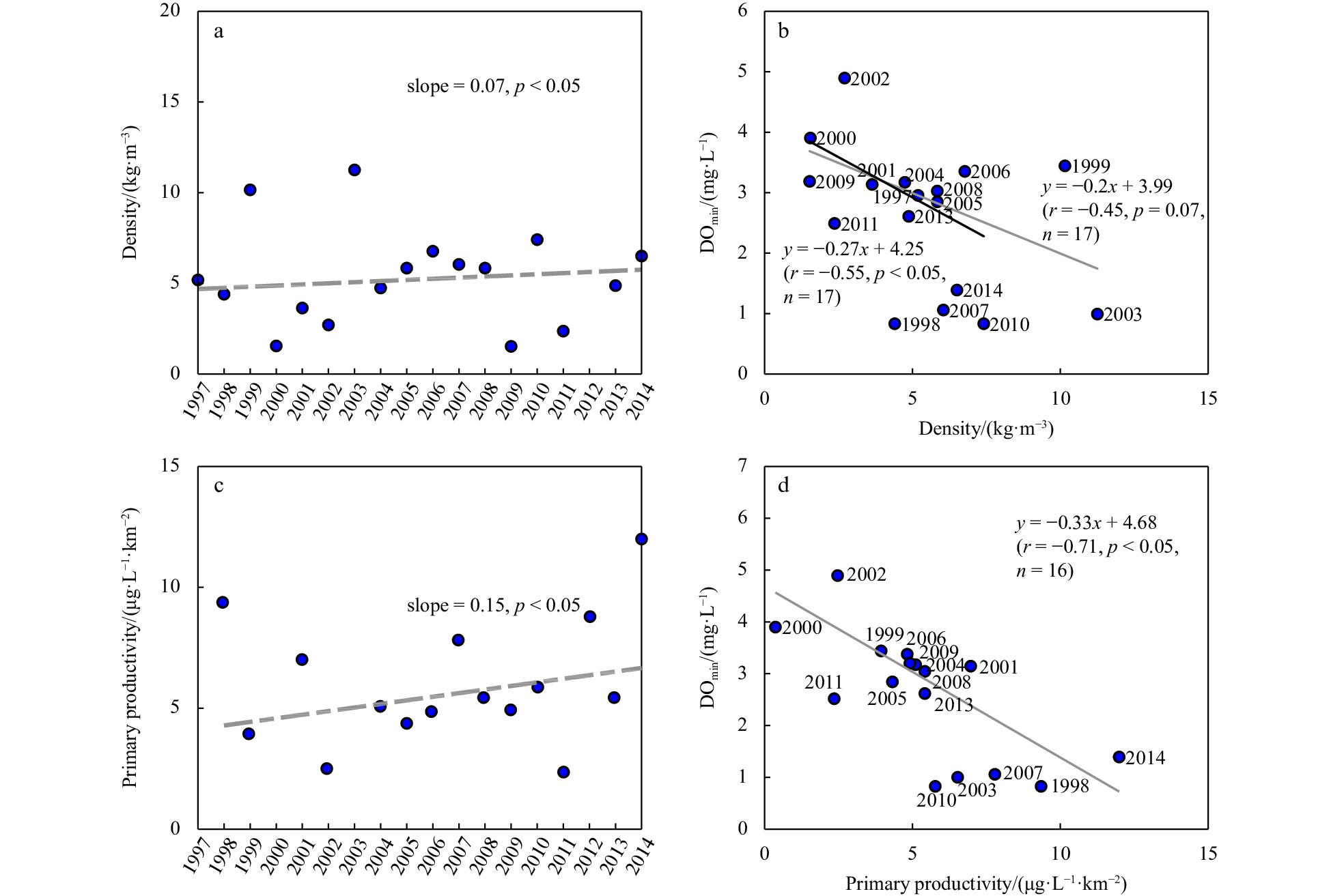
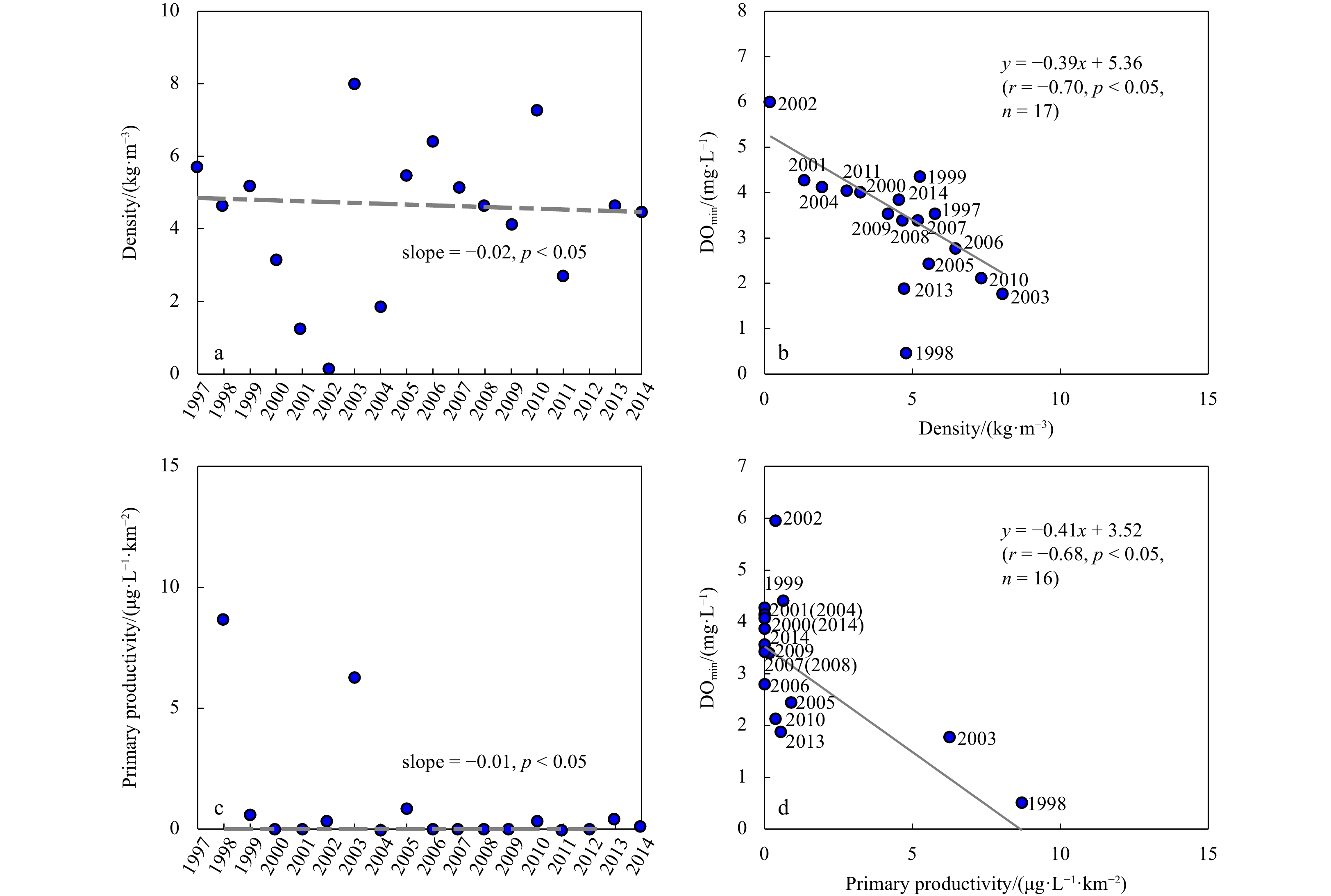

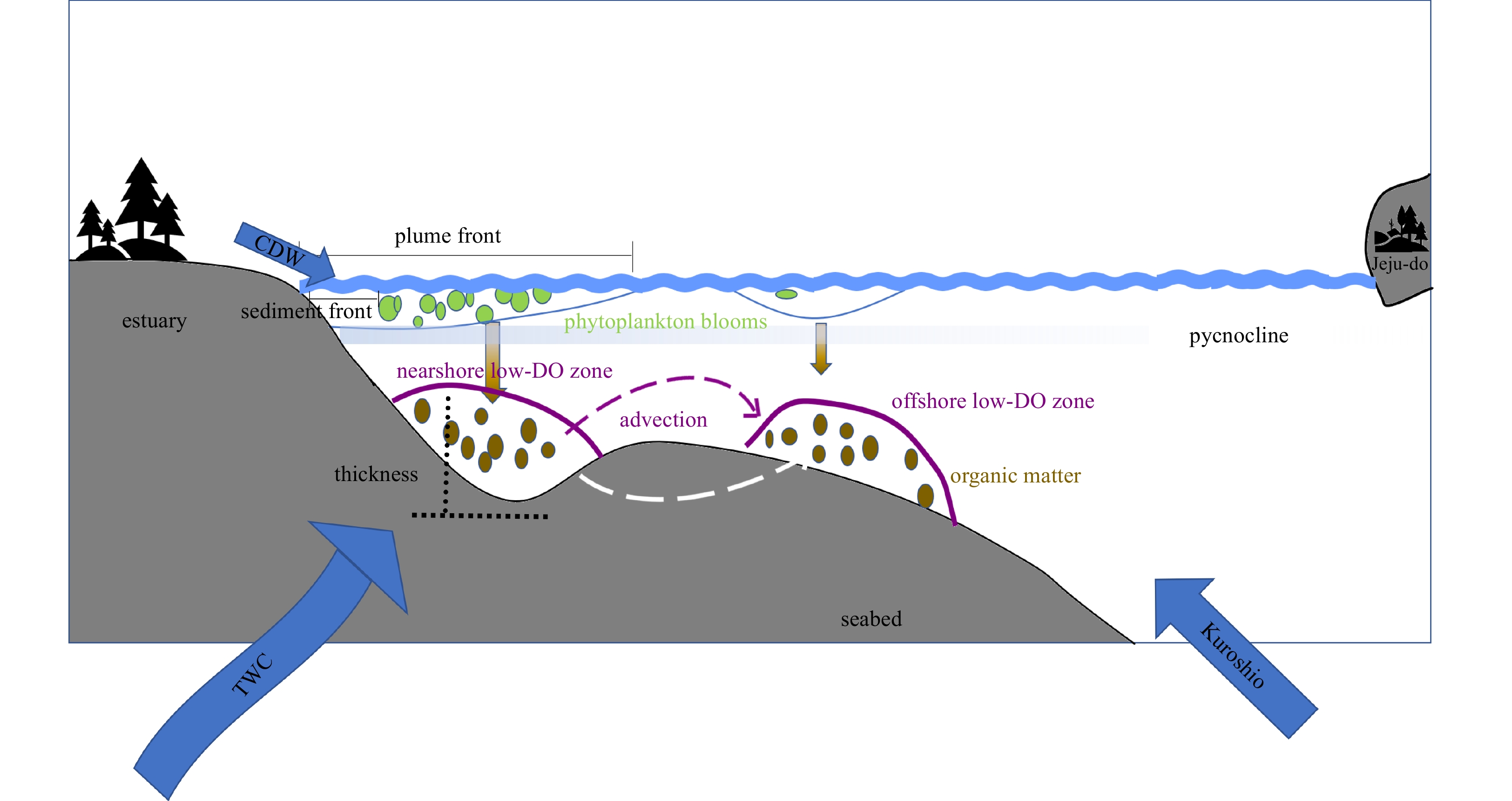

, Available online ,
doi: 10.1007/s13131-023-2209-3
Abstract:
The spaceborne platform has unprecedently provided the global eddy-permitting (typically ~0.25°) products of Sea Surface Salinity (SSS), however the existing SSS products can hardly resolve mesoscale motions due to the heavy noises therein and the over-smoothing in denoising processes. By means of the Multi-fractal Fusion (MFF), the high-resolution SSS product is synthesized with the template of Sea Surface Temperature (SST). Two low-resolution SSS products and four SST products are considered as the source data and the templates respectively to determine the best combination. The fused products are validated by the in situ observations and intercompared via SSS maps, Singularity Exponent maps and wavenumber spectra. The results demonstrate that the MFF can perform a good work in mitigating the noises and improving the resolution. The Climate Change Initiative (CCI) SSS + the REMote Sensing System (REMSS) SST can produce the 0.1° denoised product whose global mean STandard Derivation (STD) against Argo is 0.21 psu and the feature resolution can reach 30-40 km.
The spaceborne platform has unprecedently provided the global eddy-permitting (typically ~0.25°) products of Sea Surface Salinity (SSS), however the existing SSS products can hardly resolve mesoscale motions due to the heavy noises therein and the over-smoothing in denoising processes. By means of the Multi-fractal Fusion (MFF), the high-resolution SSS product is synthesized with the template of Sea Surface Temperature (SST). Two low-resolution SSS products and four SST products are considered as the source data and the templates respectively to determine the best combination. The fused products are validated by the in situ observations and intercompared via SSS maps, Singularity Exponent maps and wavenumber spectra. The results demonstrate that the MFF can perform a good work in mitigating the noises and improving the resolution. The Climate Change Initiative (CCI) SSS + the REMote Sensing System (REMSS) SST can produce the 0.1° denoised product whose global mean STandard Derivation (STD) against Argo is 0.21 psu and the feature resolution can reach 30-40 km.


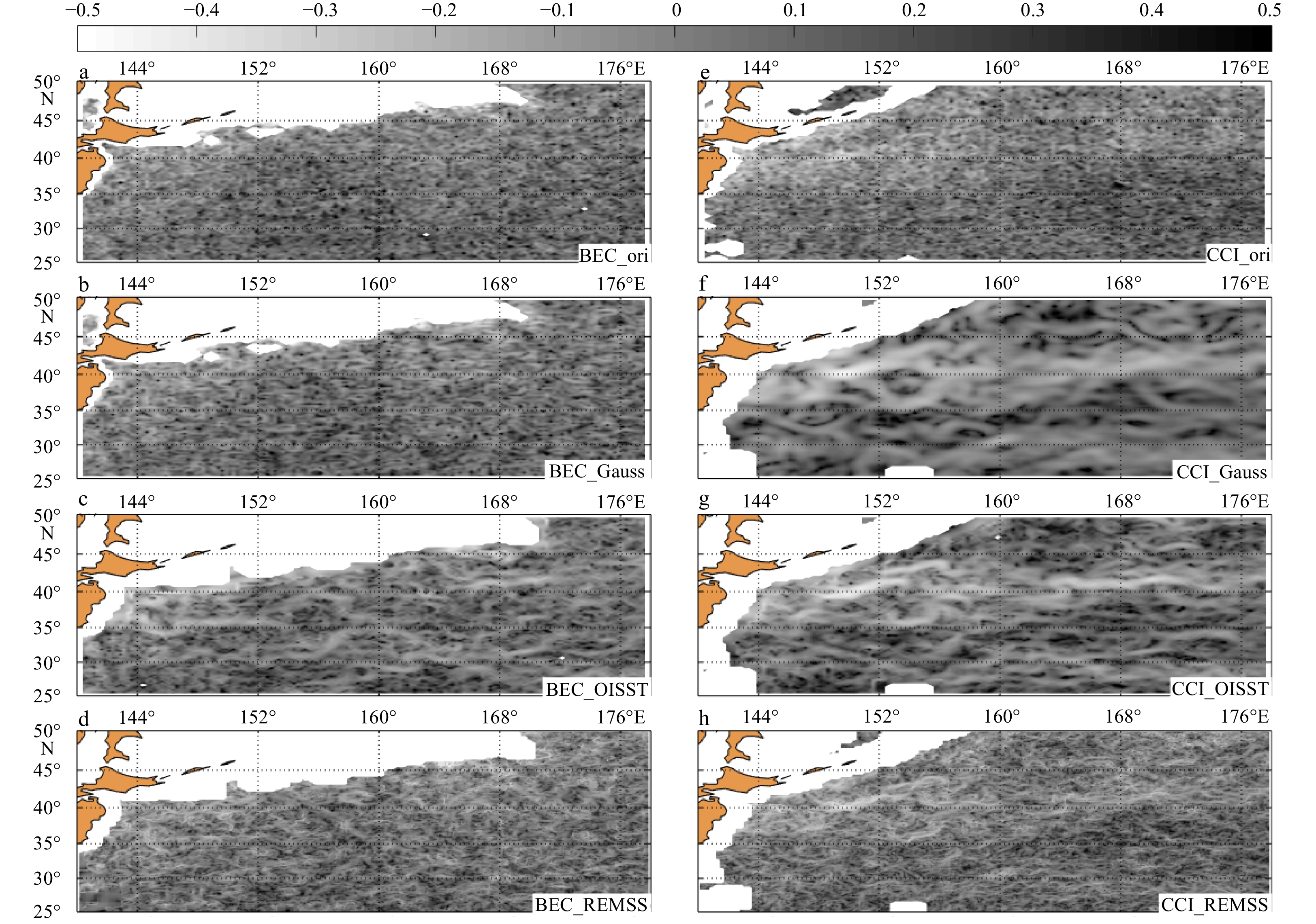

, Available online ,
doi: 10.1007/s13131-023-2210-x
Abstract:
Retrieval of thin-ice thickness (TIT) using thermodynamic modeling is sensitive to the parameterization of the independent variables (coded in the model) and the uncertainty of the measured input variables. This article examines the deviation of the classical model’s TIT output when using different parameterization schemes and the sensitivity of the output to the ice thickness. Moreover, it estimates the uncertainty of the output in response to the uncertainties of the input variables. The parameterized independent variables include atmospheric longwave emissivity, air density, specific heat of air, latent heat of ice, conductivity of ice, snow depth, and snow conductivity. Measured input parameters include air temperature, ice surface temperature, and wind speed. Among the independent variables, the results show that the highest deviation is caused by adjusting the parameterization of snow conductivity and depth, followed ice conductivity. The sensitivity of the output TIT to ice thickness is highest when using parameterization of ice conductivity, atmospheric emissivity, and snow conductivity and depth. The retrieved TIT obtained using each parameterization scheme is validated using in situ measurements and satellite-retrieved data. From in situ measurements, the uncertainties of the measured air temperature and surface temperature are found to be high. The resulting uncertainties of TIT are evaluated using perturbations of the input data selected based on the probability distribution of the measurement error. The results show that the overall uncertainty of TIT to air temperature, surface temperature, and wind speed uncertainty is around 0.09 m, 0.049 m, and −0.005 m, respectively.
Retrieval of thin-ice thickness (TIT) using thermodynamic modeling is sensitive to the parameterization of the independent variables (coded in the model) and the uncertainty of the measured input variables. This article examines the deviation of the classical model’s TIT output when using different parameterization schemes and the sensitivity of the output to the ice thickness. Moreover, it estimates the uncertainty of the output in response to the uncertainties of the input variables. The parameterized independent variables include atmospheric longwave emissivity, air density, specific heat of air, latent heat of ice, conductivity of ice, snow depth, and snow conductivity. Measured input parameters include air temperature, ice surface temperature, and wind speed. Among the independent variables, the results show that the highest deviation is caused by adjusting the parameterization of snow conductivity and depth, followed ice conductivity. The sensitivity of the output TIT to ice thickness is highest when using parameterization of ice conductivity, atmospheric emissivity, and snow conductivity and depth. The retrieved TIT obtained using each parameterization scheme is validated using in situ measurements and satellite-retrieved data. From in situ measurements, the uncertainties of the measured air temperature and surface temperature are found to be high. The resulting uncertainties of TIT are evaluated using perturbations of the input data selected based on the probability distribution of the measurement error. The results show that the overall uncertainty of TIT to air temperature, surface temperature, and wind speed uncertainty is around 0.09 m, 0.049 m, and −0.005 m, respectively.
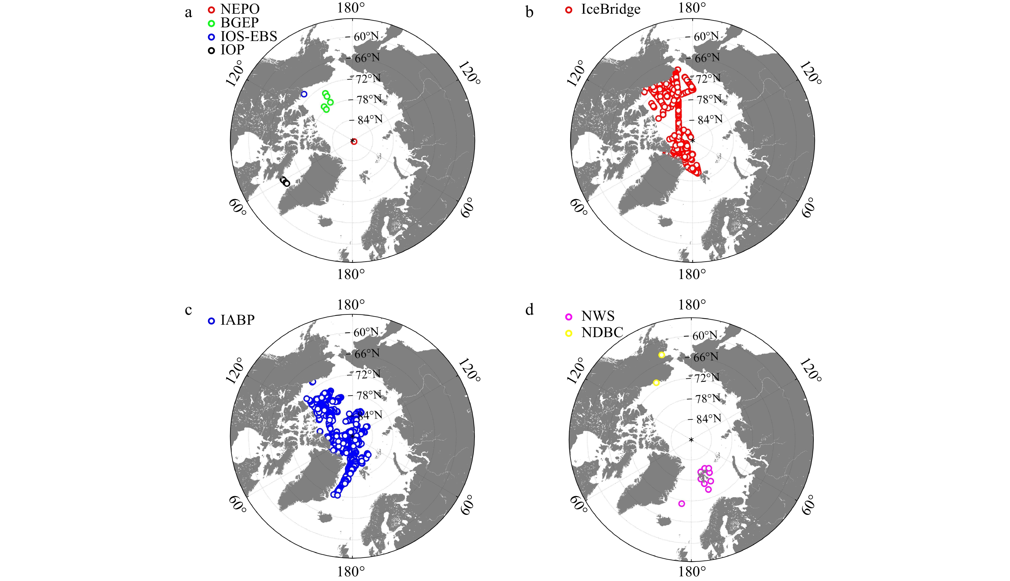
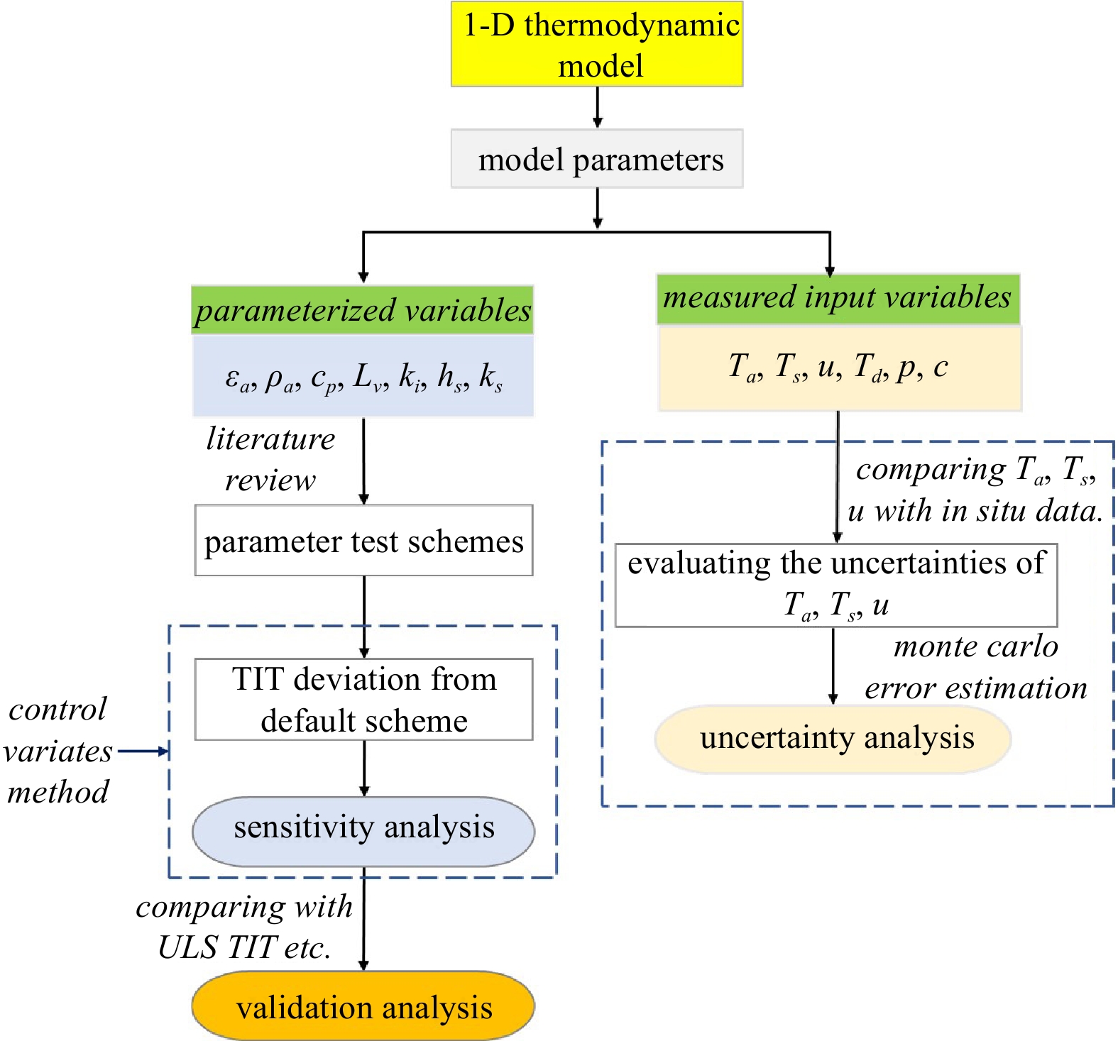
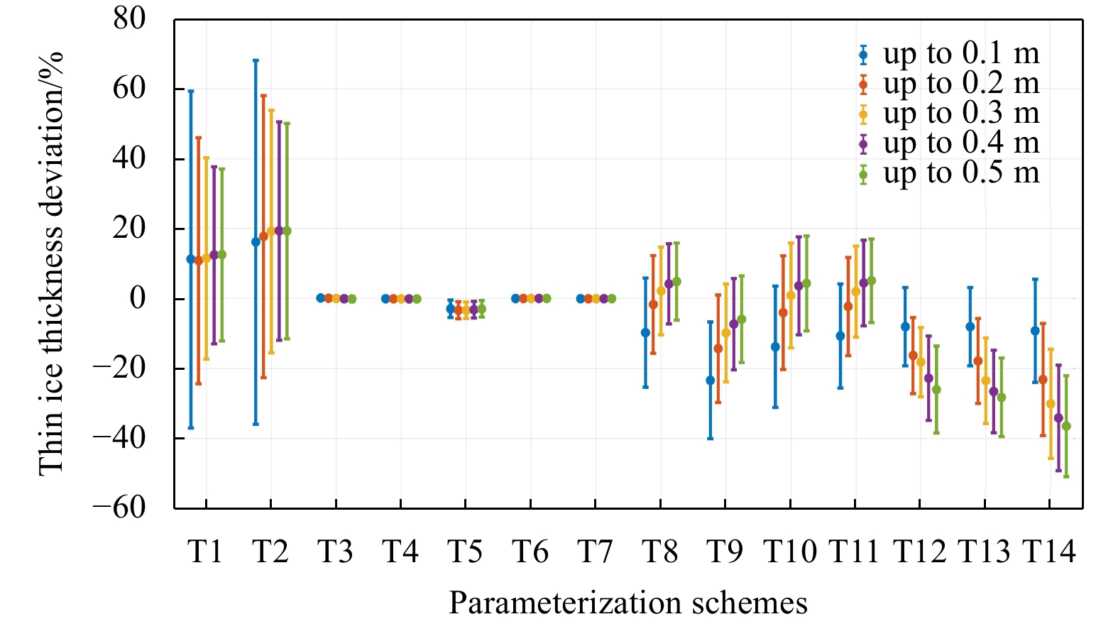


, Available online ,
doi: 10.1007/s13131-023-2282-7
Abstract:
Under global climate change, water flow and related nutrient biogeochemistry in the Arctic are changing at an unprecedented rate, and potentially affect nutrient cycling in the Arctic Ocean. However, nutrient fluxes via submarine groundwater discharge (SGD) are potentially important yet poorly understood in the Arctic. Here we quantified that nutrient fluxes through radium-derived SGD were three orders of magnitude higher than those from the local river and constituted 25-96% of the total nutrient inputs into the Kongsfjorden. These large groundwater nutrient fluxes with high N/P ratio (average 99) may change the biomass and community structure of phytoplankton. Meanwhile, combining other SGD study cases around the Arctic region, SGD rates tend to increase over the past three decades, possibly on account of the effects of global warming. The SGD-derived nutrient may cause the increase of net primary productivity in the Arctic Ocean. The results will provide important basic data for land-ocean interactions in the typical fjord of the Arctic under the influence of global warming.
Under global climate change, water flow and related nutrient biogeochemistry in the Arctic are changing at an unprecedented rate, and potentially affect nutrient cycling in the Arctic Ocean. However, nutrient fluxes via submarine groundwater discharge (SGD) are potentially important yet poorly understood in the Arctic. Here we quantified that nutrient fluxes through radium-derived SGD were three orders of magnitude higher than those from the local river and constituted 25-96% of the total nutrient inputs into the Kongsfjorden. These large groundwater nutrient fluxes with high N/P ratio (average 99) may change the biomass and community structure of phytoplankton. Meanwhile, combining other SGD study cases around the Arctic region, SGD rates tend to increase over the past three decades, possibly on account of the effects of global warming. The SGD-derived nutrient may cause the increase of net primary productivity in the Arctic Ocean. The results will provide important basic data for land-ocean interactions in the typical fjord of the Arctic under the influence of global warming.

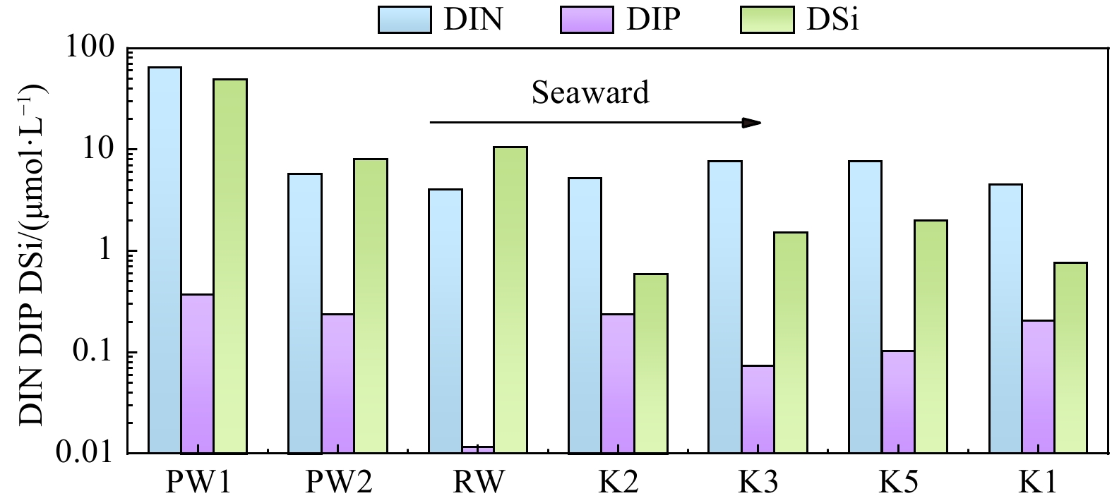

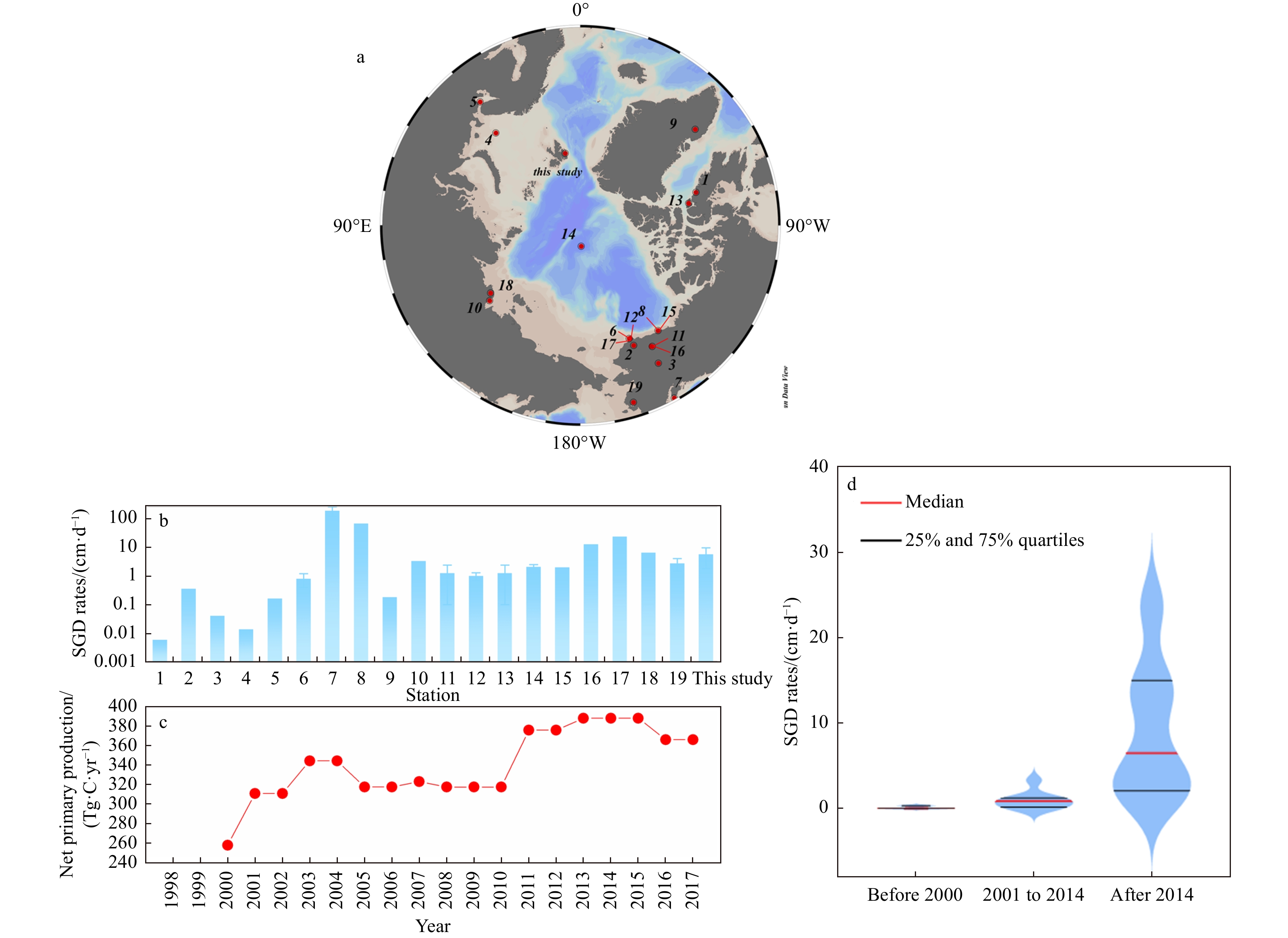
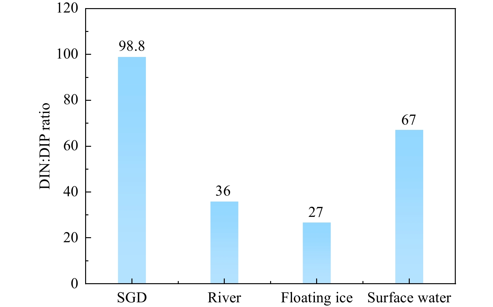
, Available online
Abstract:
Based on the Ocean Reanalysis System version 5 (ORAS5) and the fifth-generation reanalysis datasets (ERA5) derived from Medium-Range Weather Forecasts (ECMWF), we investigate the different impacts of the Central Pacific (CP) El Niño and the Eastern Pacific (EP) El Niño on the Southern Ocean (SO) mixed layer depth (MLD) during austral winter. The MLD response to the EP El Niño shows a dipole pattern in the South Pacific, namely the MLD dipole, which is the leading El Niño-induced MLD variability in the SO. The tropical Pacific warm sea surface temperature anomaly (SSTA) signal associated with the EP El Niño excites a Rossby wave train propagating southeastward and then enhances the Amundsen Sea Low (ASL). This results in an anomalous cyclone over the Amundsen Sea. As a result, the anomalous southerly wind to the west of this anomalous cyclone advects colder and drier air into the southeast of New Zealand, leading to surface cooling through less total surface heat flux, especially surface sensible heat (SH) flux and latent heat (LH) flux, and thus contributing to the ML deepening. The east of the anomalous cyclone brings warmer and wetter air to the southwest of Chile, but the total heat flux anomaly shows no significant change. The warm air promotes the sea ice melting and maintains fresh water, which strengthens stratification. This results in a shallower MLD. During the CP El Niño, the response of MLD shows a separate negative MLD anomaly center in the central South Pacific. The Rossby wave train triggered by the warm SSTA in the central Pacific Ocean spreads to the Amundsen Sea, which weakens the ASL. Therefore, the anomalous anticyclone dominates the Amundsen Sea. Consequently, the anomalous northerly wind to the west of anomalous anticyclone advects warmer and wetter air into the central and southern Pacific, causing surface warming through increased SH, LH and longwave (LW) radiation flux, and thus contributing to the ML shoaling. However, to the east of the anomalous anticyclone, there is no statistically significant impact on the MLD.
Based on the Ocean Reanalysis System version 5 (ORAS5) and the fifth-generation reanalysis datasets (ERA5) derived from Medium-Range Weather Forecasts (ECMWF), we investigate the different impacts of the Central Pacific (CP) El Niño and the Eastern Pacific (EP) El Niño on the Southern Ocean (SO) mixed layer depth (MLD) during austral winter. The MLD response to the EP El Niño shows a dipole pattern in the South Pacific, namely the MLD dipole, which is the leading El Niño-induced MLD variability in the SO. The tropical Pacific warm sea surface temperature anomaly (SSTA) signal associated with the EP El Niño excites a Rossby wave train propagating southeastward and then enhances the Amundsen Sea Low (ASL). This results in an anomalous cyclone over the Amundsen Sea. As a result, the anomalous southerly wind to the west of this anomalous cyclone advects colder and drier air into the southeast of New Zealand, leading to surface cooling through less total surface heat flux, especially surface sensible heat (SH) flux and latent heat (LH) flux, and thus contributing to the ML deepening. The east of the anomalous cyclone brings warmer and wetter air to the southwest of Chile, but the total heat flux anomaly shows no significant change. The warm air promotes the sea ice melting and maintains fresh water, which strengthens stratification. This results in a shallower MLD. During the CP El Niño, the response of MLD shows a separate negative MLD anomaly center in the central South Pacific. The Rossby wave train triggered by the warm SSTA in the central Pacific Ocean spreads to the Amundsen Sea, which weakens the ASL. Therefore, the anomalous anticyclone dominates the Amundsen Sea. Consequently, the anomalous northerly wind to the west of anomalous anticyclone advects warmer and wetter air into the central and southern Pacific, causing surface warming through increased SH, LH and longwave (LW) radiation flux, and thus contributing to the ML shoaling. However, to the east of the anomalous anticyclone, there is no statistically significant impact on the MLD.
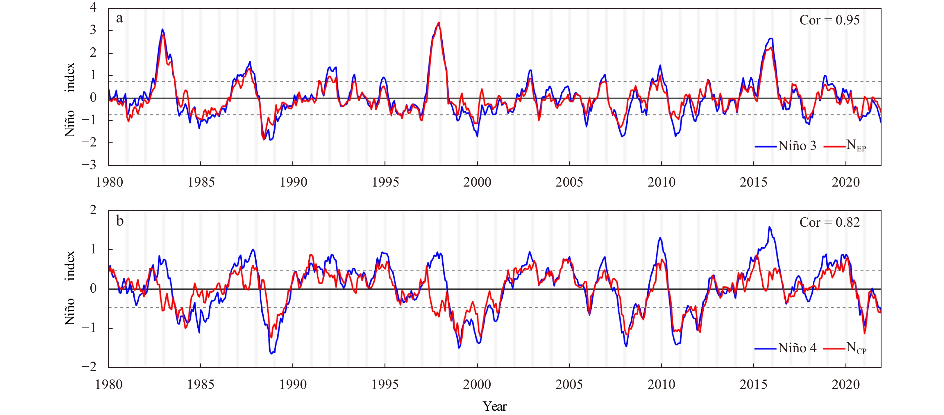

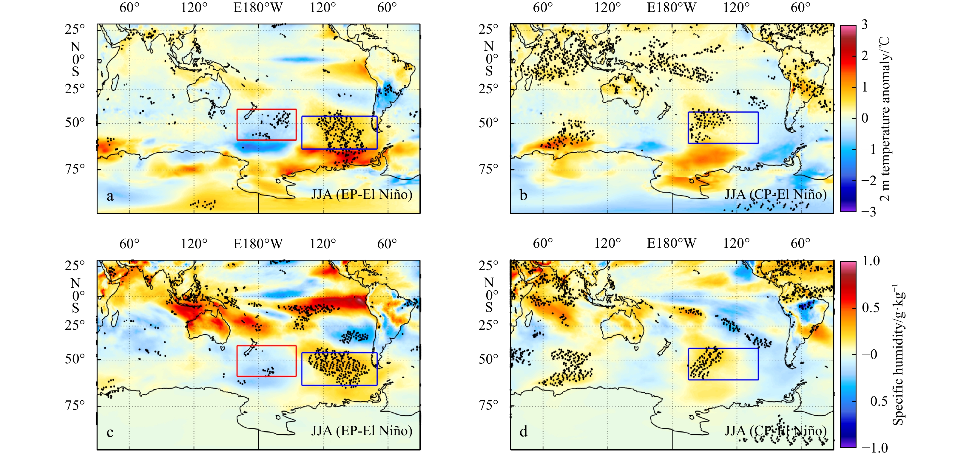


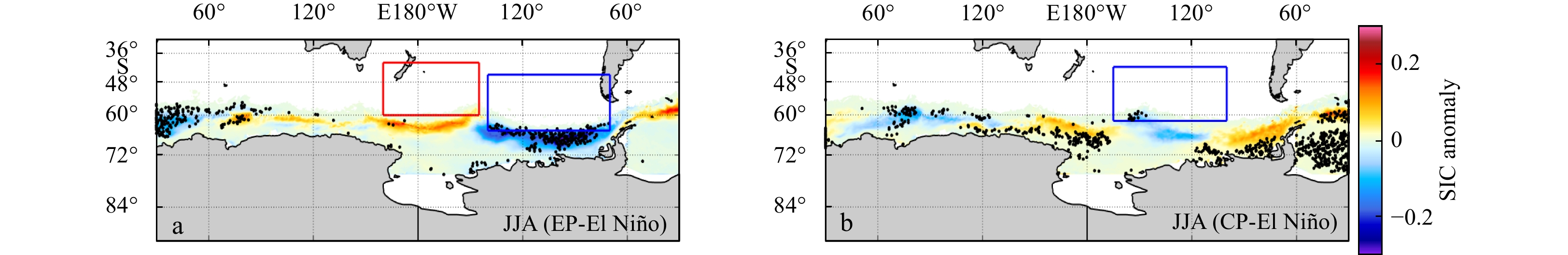
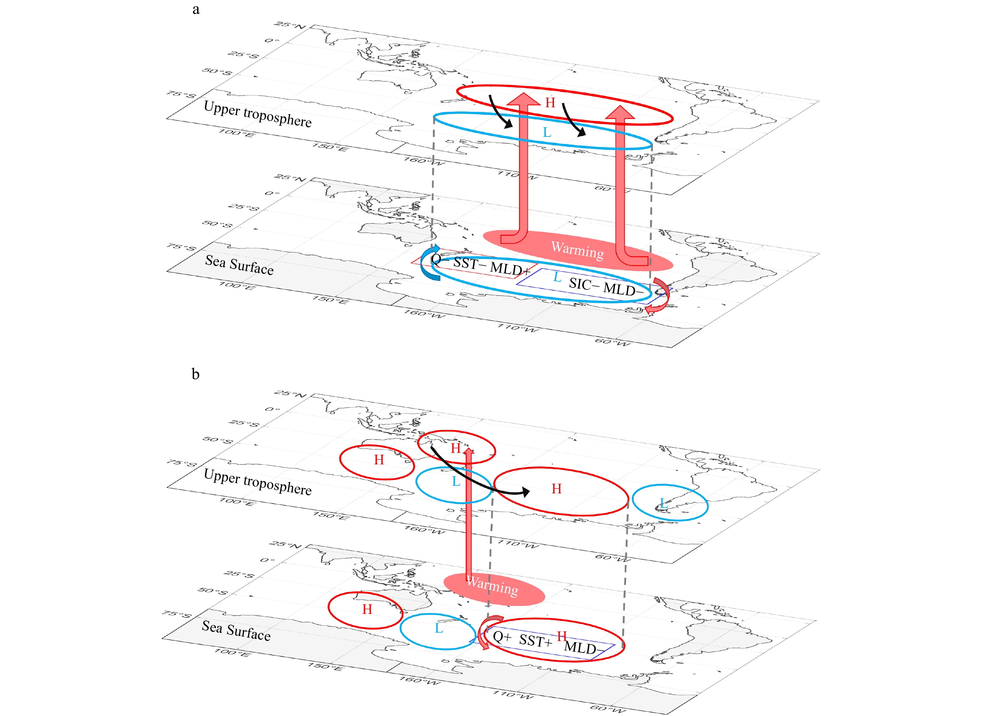
, Available online
Abstract:
Global carbon cycle has received extensive attention, among which the river-estuary system is one of the important links connecting the carbon cycle between land and ocean. In this paper, the distribution and control factors of particulate organic carbon (POC) were studied by using the data of organic carbon contents and its carbon isotopic composition (δ13C) in the mainstream and estuary of Passur River in the Sundarban area, combined with the hydrological and biological data measured by CTD. The results show that POC content ranged from 0.263 to 9.292 mg/L, and the POC content in the river section (averaged 4.129 mg/L) was significantly higher than that in the estuary area (averaged 0.858 mg/L). Two distinct stages of POC transport from land to sea in the Sundarban area were identified. The first stage occurred in the river section, where POC distribution was mainly controlled by the dynamic process of runoff and the organic carbon was mainly terrestrial source. The second stage occurred during estuarine mixing, where the POC distribution was mainly controlled by the mixing process of seawater and freshwater. The source of POC was predominantly marine and exhibiting vertical differences. The surface and middle layers were primarily influenced by marine sources, while the bottom layer was jointly controlled by terrestrial and marine sources of organic carbon. These findings are of great significance for understanding the carbon cycle in such a large mangrove ecosystem like the Sundarban Mangrove.
Global carbon cycle has received extensive attention, among which the river-estuary system is one of the important links connecting the carbon cycle between land and ocean. In this paper, the distribution and control factors of particulate organic carbon (POC) were studied by using the data of organic carbon contents and its carbon isotopic composition (δ13C) in the mainstream and estuary of Passur River in the Sundarban area, combined with the hydrological and biological data measured by CTD. The results show that POC content ranged from 0.263 to 9.292 mg/L, and the POC content in the river section (averaged 4.129 mg/L) was significantly higher than that in the estuary area (averaged 0.858 mg/L). Two distinct stages of POC transport from land to sea in the Sundarban area were identified. The first stage occurred in the river section, where POC distribution was mainly controlled by the dynamic process of runoff and the organic carbon was mainly terrestrial source. The second stage occurred during estuarine mixing, where the POC distribution was mainly controlled by the mixing process of seawater and freshwater. The source of POC was predominantly marine and exhibiting vertical differences. The surface and middle layers were primarily influenced by marine sources, while the bottom layer was jointly controlled by terrestrial and marine sources of organic carbon. These findings are of great significance for understanding the carbon cycle in such a large mangrove ecosystem like the Sundarban Mangrove.


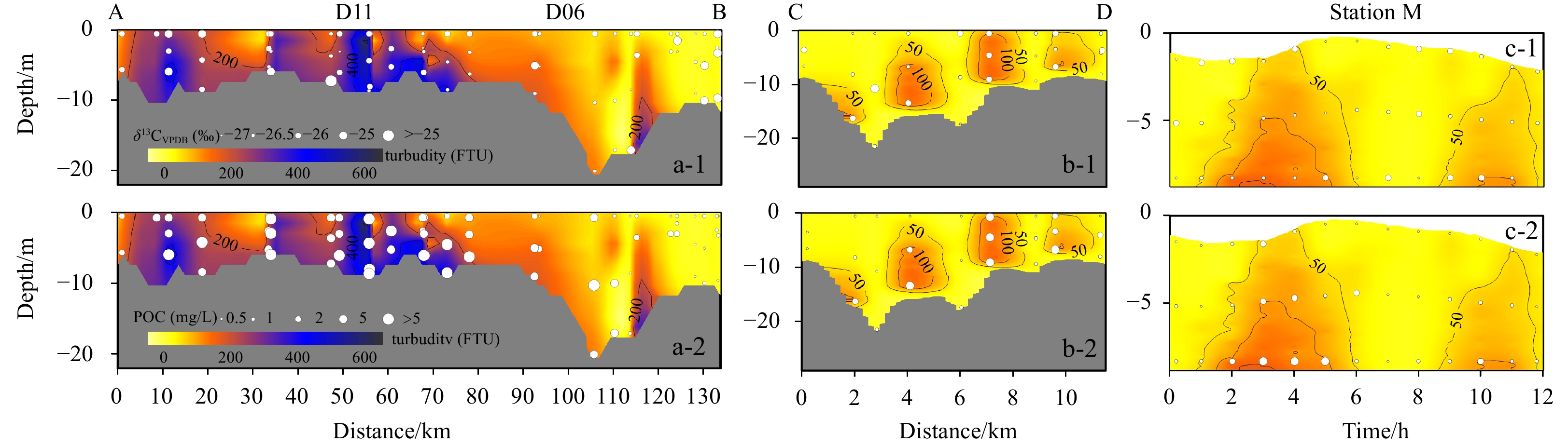
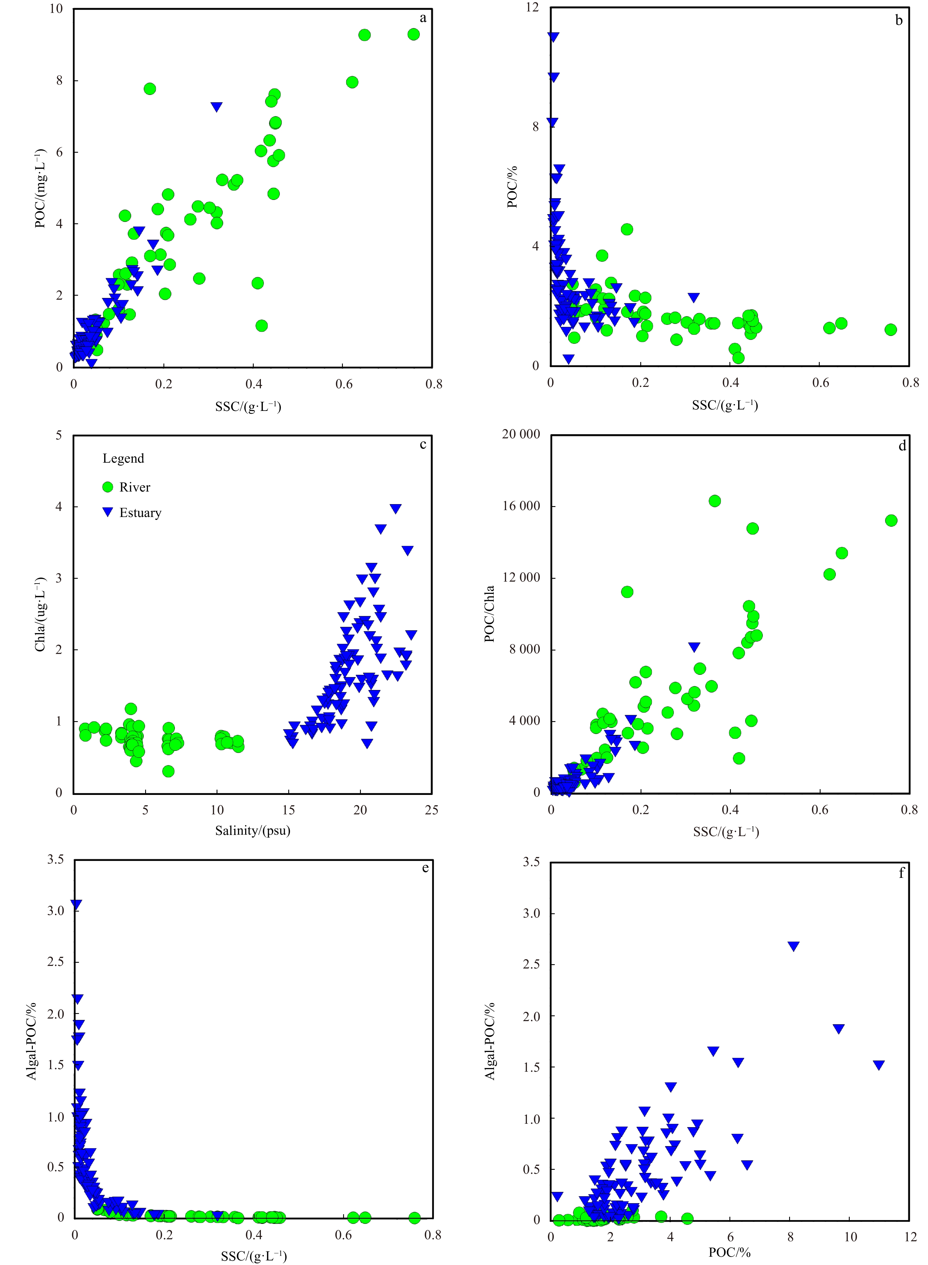
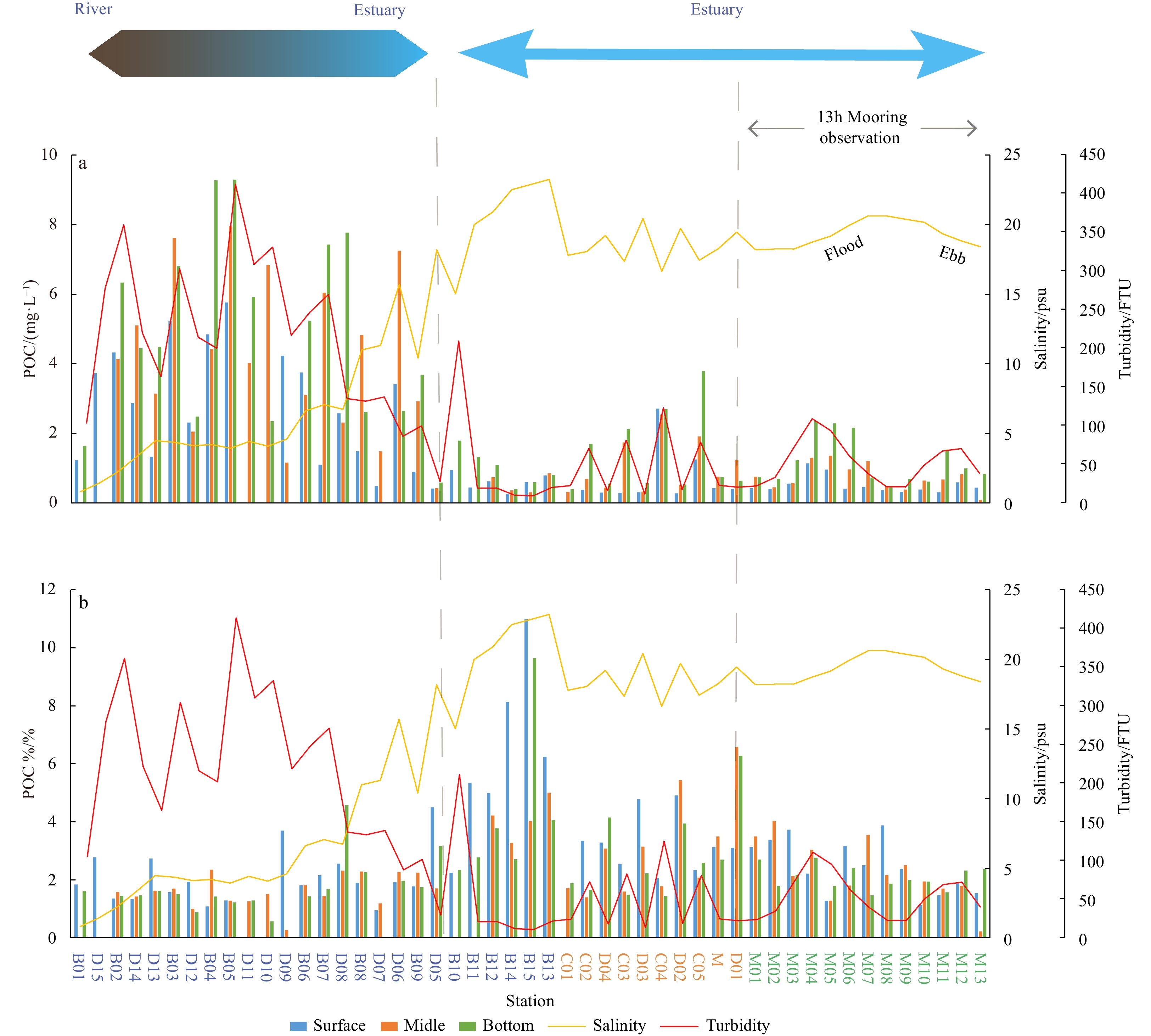


, Available online
Abstract:
Ocean temperature is an important physical variable in marine ecosystems, and ocean temperature prediction is an important research objective in ocean-related fields. Currently, one of the commonly used methods for ocean temperature prediction is based on data-driven, but research on this method is mostly limited to the sea surface, with few studies on the prediction of internal ocean temperature. Existing graph neural network-based methods usually use predefined graphs or learned static graphs, which cannot capture the dynamic associations among data. In this study, we propose a novel dynamic spatiotemporal graph neural network (DSTGN) to predict three-dimensional ocean temperature (3D-OT), which combines static graph learning and dynamic graph learning to automatically mine two unknown dependencies between sequences based on the original 3D-OT data without prior knowledge. Temporal and spatial dependencies in the time series were then captured using temporal and graph convolutions. We also integrated dynamic graph learning, static graph learning, graph convolution, and temporal convolution into an end-to-end framework for 3D-OT prediction using time-series grid data. In this study, we conducted prediction experiments using high-resolution 3D-OT from the Copernicus global ocean physical reanalysis, with data covering the vertical variation of temperature from the sea surface to 1,000 m below the sea surface. We compared five mainstream models that are commonly used for ocean temperature prediction, and the results showed that the method achieved the best prediction results at all prediction scales.
Ocean temperature is an important physical variable in marine ecosystems, and ocean temperature prediction is an important research objective in ocean-related fields. Currently, one of the commonly used methods for ocean temperature prediction is based on data-driven, but research on this method is mostly limited to the sea surface, with few studies on the prediction of internal ocean temperature. Existing graph neural network-based methods usually use predefined graphs or learned static graphs, which cannot capture the dynamic associations among data. In this study, we propose a novel dynamic spatiotemporal graph neural network (DSTGN) to predict three-dimensional ocean temperature (3D-OT), which combines static graph learning and dynamic graph learning to automatically mine two unknown dependencies between sequences based on the original 3D-OT data without prior knowledge. Temporal and spatial dependencies in the time series were then captured using temporal and graph convolutions. We also integrated dynamic graph learning, static graph learning, graph convolution, and temporal convolution into an end-to-end framework for 3D-OT prediction using time-series grid data. In this study, we conducted prediction experiments using high-resolution 3D-OT from the Copernicus global ocean physical reanalysis, with data covering the vertical variation of temperature from the sea surface to 1,000 m below the sea surface. We compared five mainstream models that are commonly used for ocean temperature prediction, and the results showed that the method achieved the best prediction results at all prediction scales.

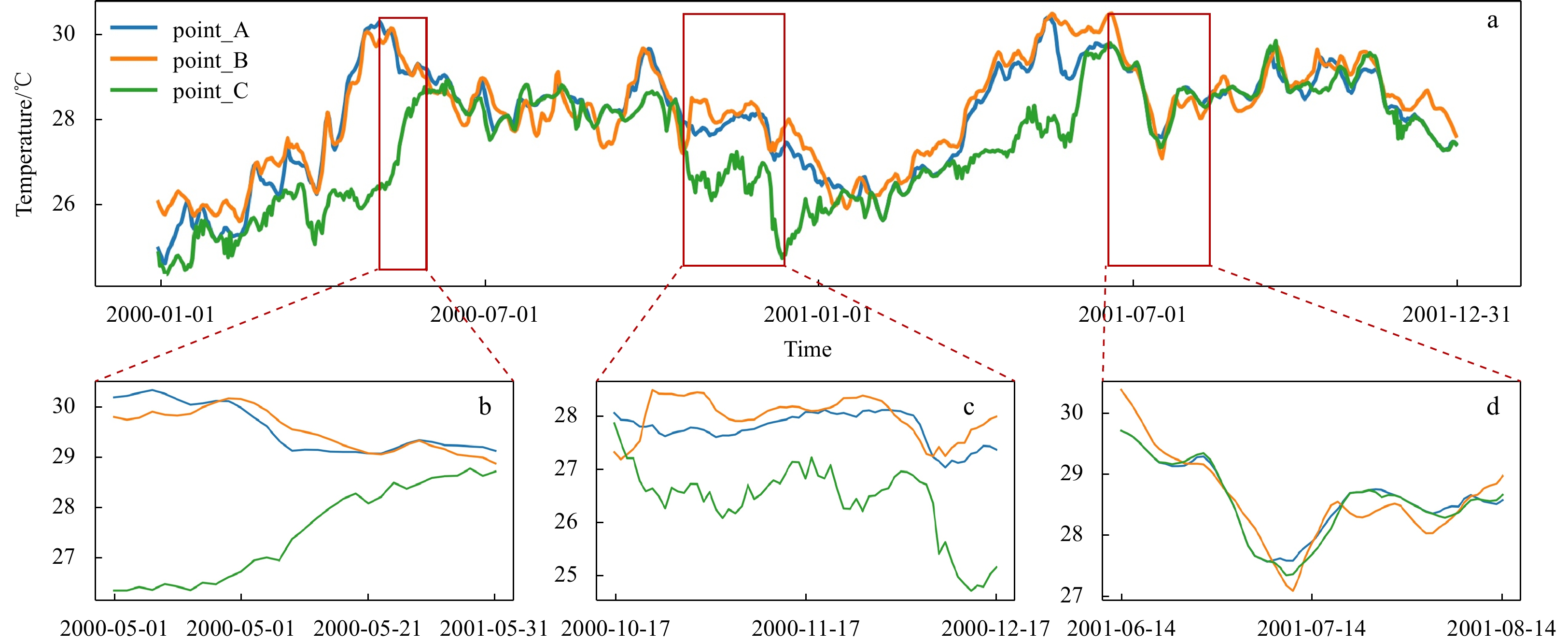

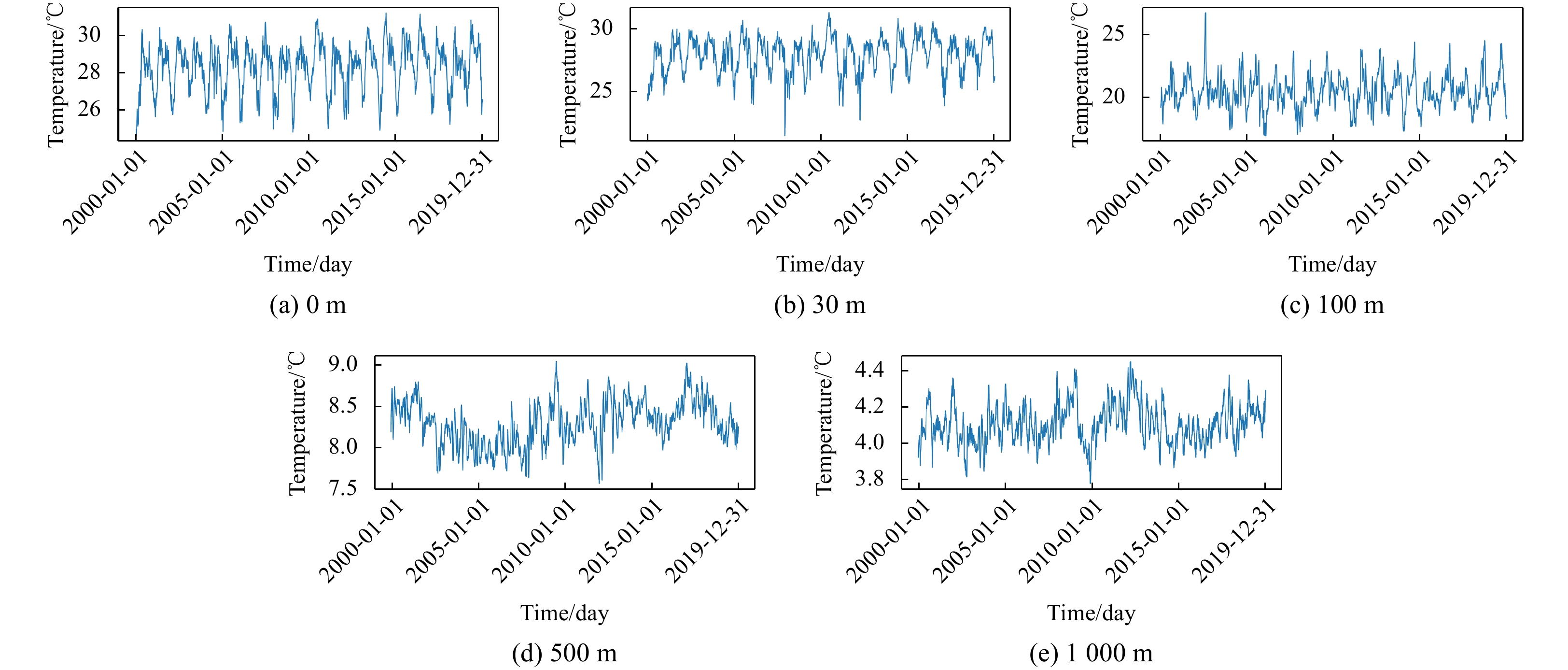
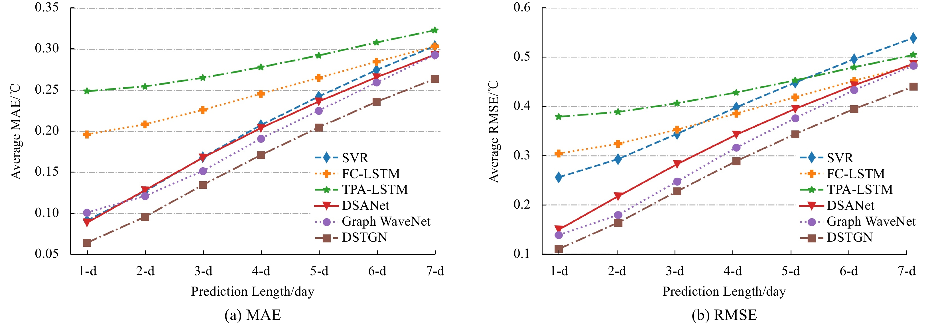
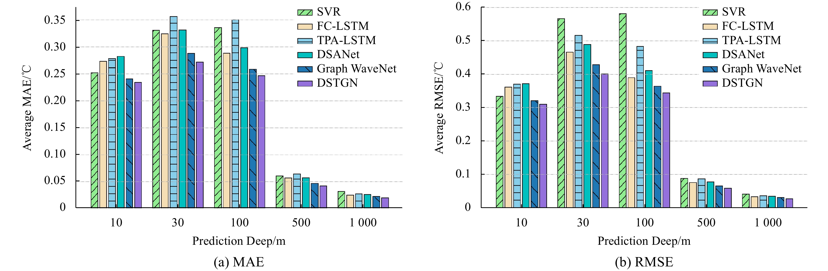


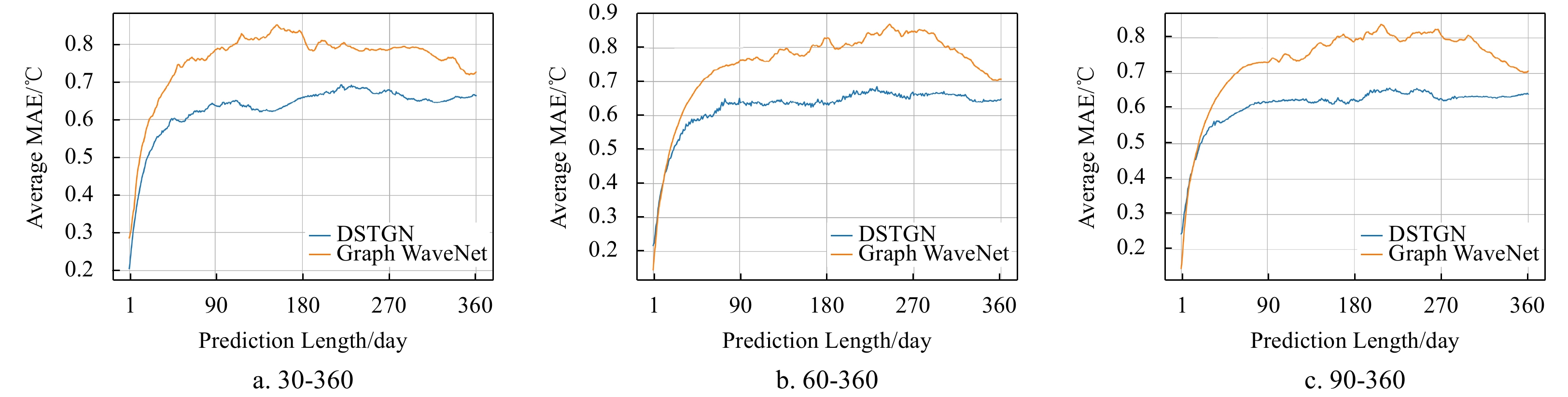
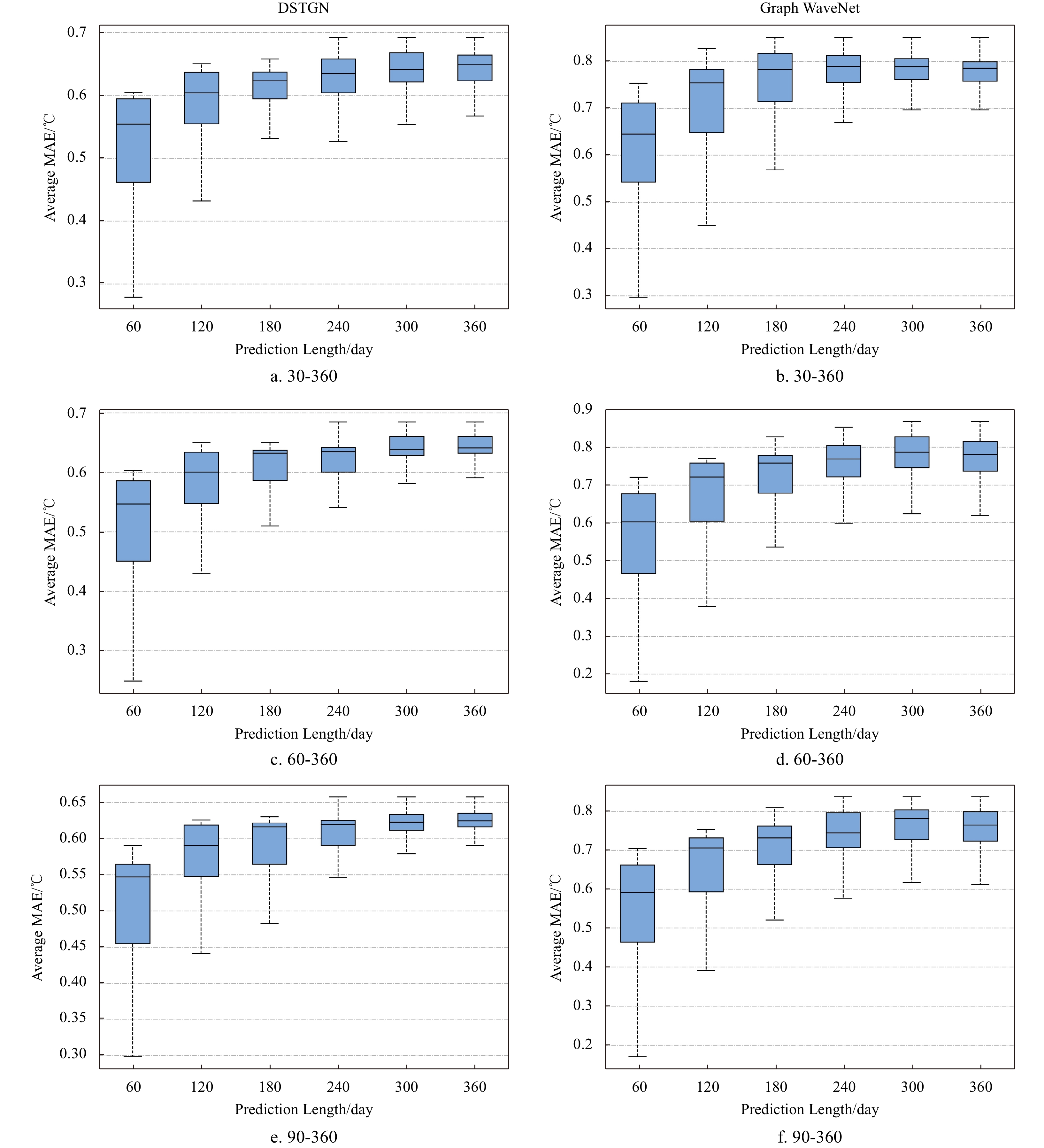
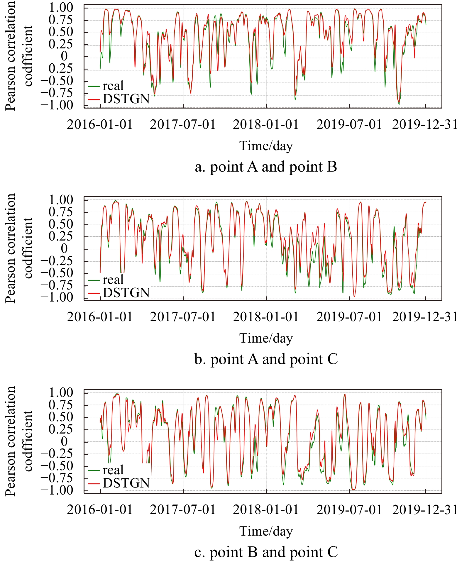
, Available online
Abstract:
The biogeochemical processes of marine sediments are influenced by bioturbation and organic carbon decomposition, which is crucial for understanding global element cycles and climate change. Two sediment cores were acquired in 2017 from abyssal basins in the central-eastern tropical Pacific to determine the bioturbation and organic carbon degradation processes. The radioactivity concentrations of 210Pb and 226Ra in the sediment cores were measured, indicating the presence of significant excess 210Pb (210Pbex) signals in the sediment cores. Besides, a manganese nodule was discovered in one core, which had a substantial influence on the distribution of 210Pbex. With the exception of this anomalous finding, the bioturbation coefficients in the remaining core were estimated to be 10.6 cm2/a using a steady-state diffusion model, greater than most of the deep-sea sediments from the Equatorial Eastern Pacific. By using a bio-diffusion model, we further calculated the degradation rates of organic carbon (8.02 ka-1), which is also higher than other areas of the Pacific. Our findings displayed the presence of a biologically active benthic ecosystem in the central-eastern tropical Pacific.
The biogeochemical processes of marine sediments are influenced by bioturbation and organic carbon decomposition, which is crucial for understanding global element cycles and climate change. Two sediment cores were acquired in 2017 from abyssal basins in the central-eastern tropical Pacific to determine the bioturbation and organic carbon degradation processes. The radioactivity concentrations of 210Pb and 226Ra in the sediment cores were measured, indicating the presence of significant excess 210Pb (210Pbex) signals in the sediment cores. Besides, a manganese nodule was discovered in one core, which had a substantial influence on the distribution of 210Pbex. With the exception of this anomalous finding, the bioturbation coefficients in the remaining core were estimated to be 10.6 cm2/a using a steady-state diffusion model, greater than most of the deep-sea sediments from the Equatorial Eastern Pacific. By using a bio-diffusion model, we further calculated the degradation rates of organic carbon (8.02 ka-1), which is also higher than other areas of the Pacific. Our findings displayed the presence of a biologically active benthic ecosystem in the central-eastern tropical Pacific.

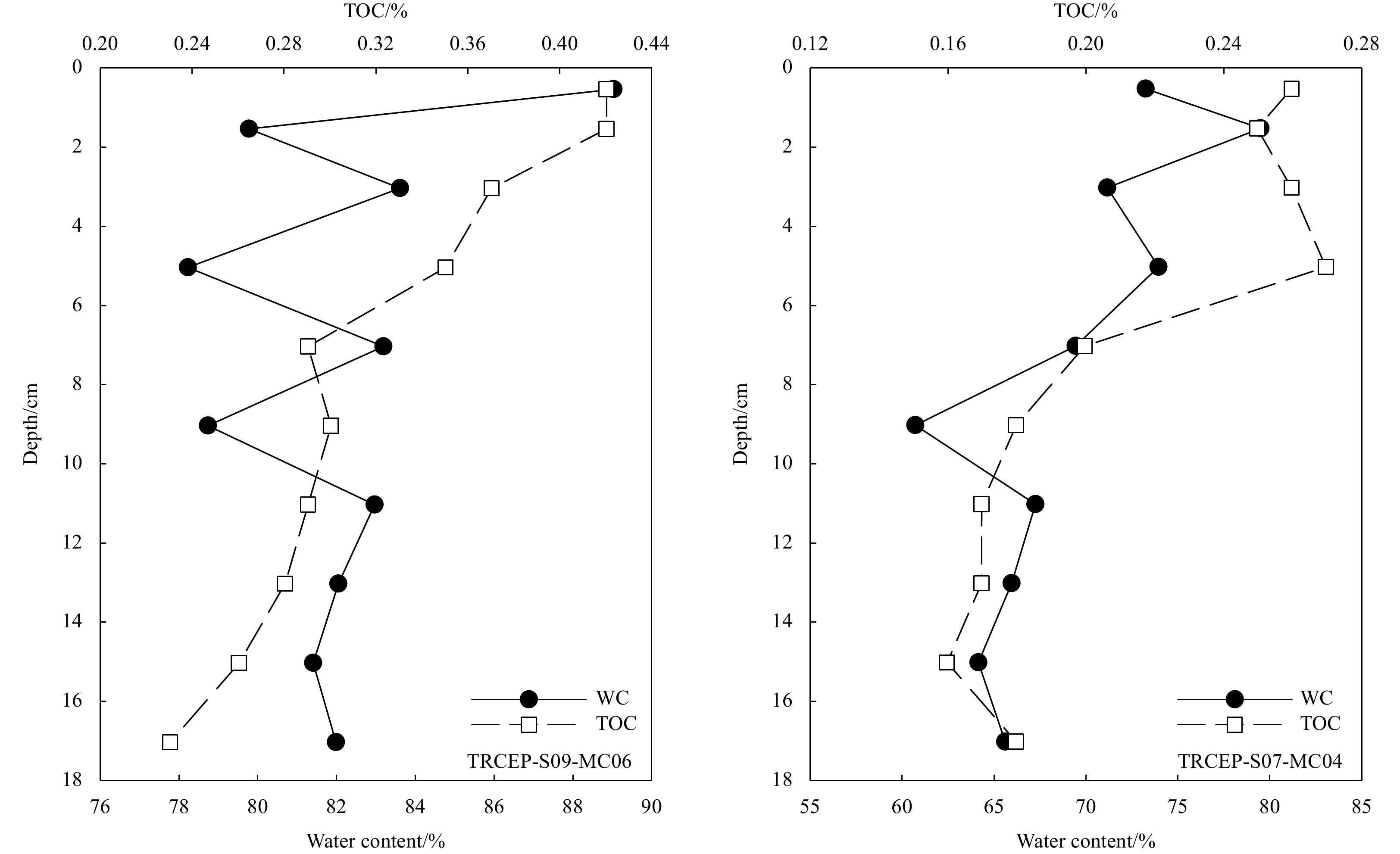
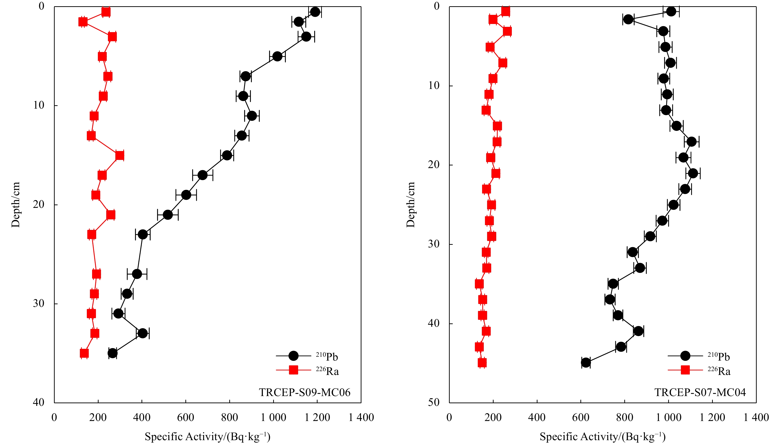
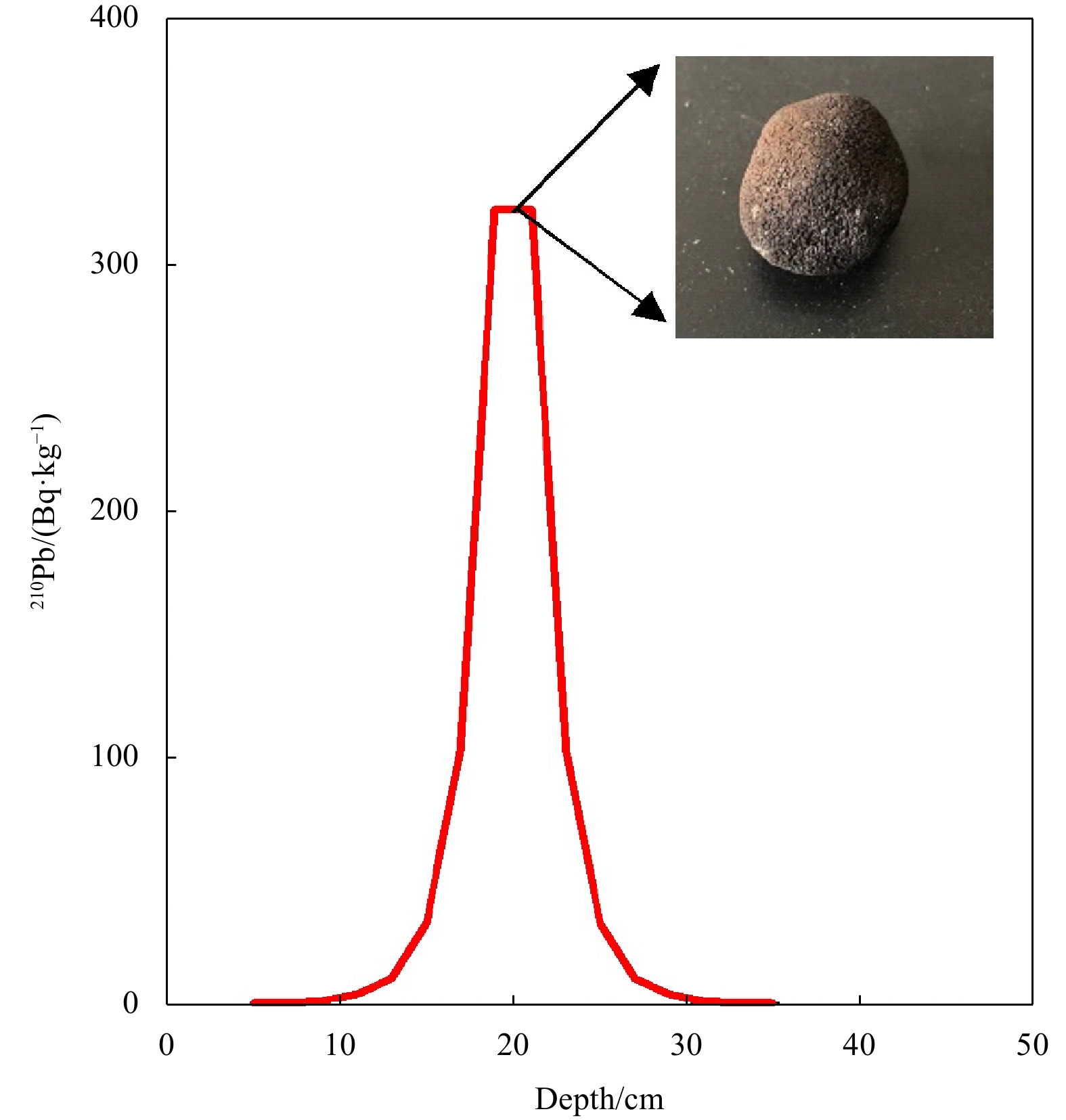

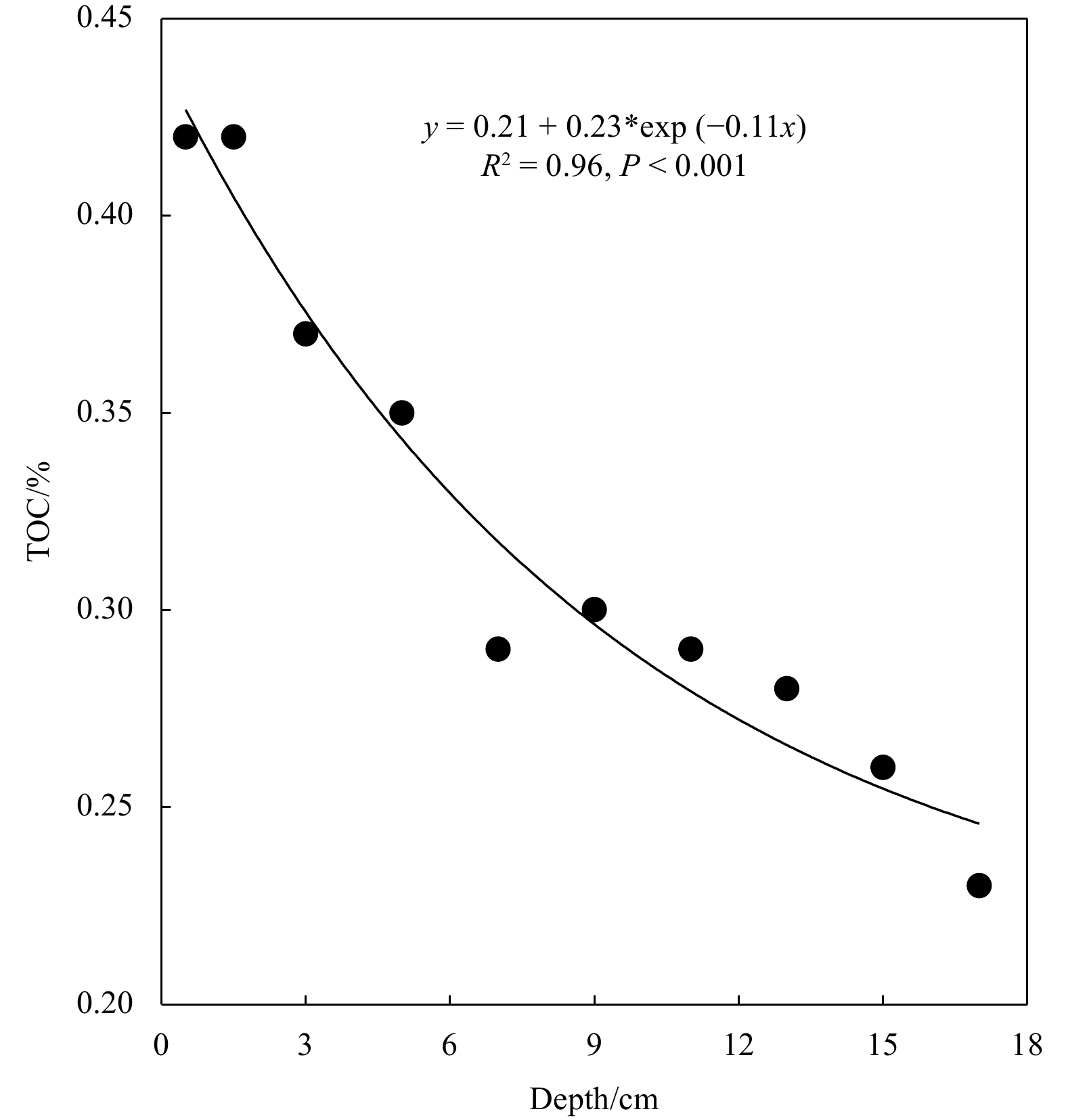
, Available online
Abstract:
This study evaluates the performance of 16 models sourced from the Coupled Model Intercomparison Project phase 6 (CMIP6) in simulating marine heatwaves (MHWs) in the South China Sea (SCS) during the historical period (1982−2014), and also investigates future changes in SCS MHWs based on simulations from three Shared Socioeconomic Pathway (SSP) scenarios (SSP126, SSP245, and SSP585) using CMIP6 models. Results demonstrate that the CMIP6 models perform well in simulating the spatial-temporal distribution and intensity of SCS MHWs, with their multi-model ensemble (MME) results showing the best performance. The reasonable agreement between the observations and CMIP6 MME reveals that the increasing trends of SCS MHWs are attributed to the warming sea surface temperature trend. Under various SSP scenarios, the year 2040 emerges as pivotal juncture for future shifts in SCS MHWs, marked by distinct variations in changing rate and amplitudes. This is characterized by an accelerated decrease in MHWs frequency and a notably heightened increase in mean intensity, duration, and total days after 2040. Furthermore, the projection results for SCS MHWs suggest that the spatial pattern of MHWs remains consistent across future periods. However, the intensity shows higher consistency only during the near-term period (2021−2050), while notable inconsistencies are observed during the medium-term (2041−2700) and long-term (2701−2100) periods under the three SSP scenarios. During the near-term period, the SCS MHWs are characterized by moderate and strong events with high frequencies and relatively shorter durations. In contrast, during the medium-term period, MHWs are also characterized by moderate and strong events, but with longer-lasting and more intense events under the SSP245 and SSP585 scenarios. However, in the long-term period, extreme MHWs become the dominant feature under the SSP585 scenario, indicating a substantial intensification of SCS MHWs, effectively establishing a near-permanent state.
This study evaluates the performance of 16 models sourced from the Coupled Model Intercomparison Project phase 6 (CMIP6) in simulating marine heatwaves (MHWs) in the South China Sea (SCS) during the historical period (1982−2014), and also investigates future changes in SCS MHWs based on simulations from three Shared Socioeconomic Pathway (SSP) scenarios (SSP126, SSP245, and SSP585) using CMIP6 models. Results demonstrate that the CMIP6 models perform well in simulating the spatial-temporal distribution and intensity of SCS MHWs, with their multi-model ensemble (MME) results showing the best performance. The reasonable agreement between the observations and CMIP6 MME reveals that the increasing trends of SCS MHWs are attributed to the warming sea surface temperature trend. Under various SSP scenarios, the year 2040 emerges as pivotal juncture for future shifts in SCS MHWs, marked by distinct variations in changing rate and amplitudes. This is characterized by an accelerated decrease in MHWs frequency and a notably heightened increase in mean intensity, duration, and total days after 2040. Furthermore, the projection results for SCS MHWs suggest that the spatial pattern of MHWs remains consistent across future periods. However, the intensity shows higher consistency only during the near-term period (2021−2050), while notable inconsistencies are observed during the medium-term (2041−2700) and long-term (2701−2100) periods under the three SSP scenarios. During the near-term period, the SCS MHWs are characterized by moderate and strong events with high frequencies and relatively shorter durations. In contrast, during the medium-term period, MHWs are also characterized by moderate and strong events, but with longer-lasting and more intense events under the SSP245 and SSP585 scenarios. However, in the long-term period, extreme MHWs become the dominant feature under the SSP585 scenario, indicating a substantial intensification of SCS MHWs, effectively establishing a near-permanent state.
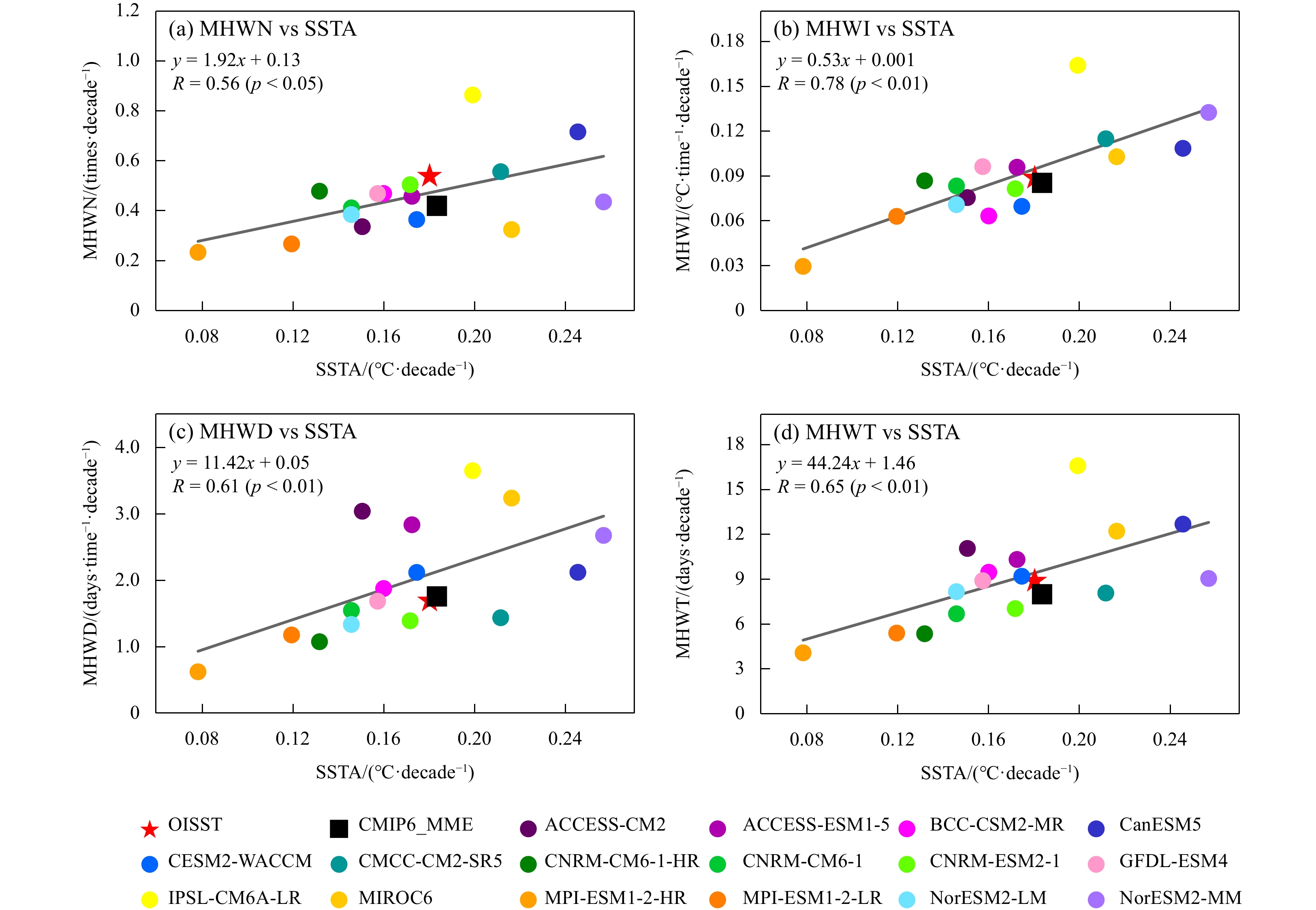
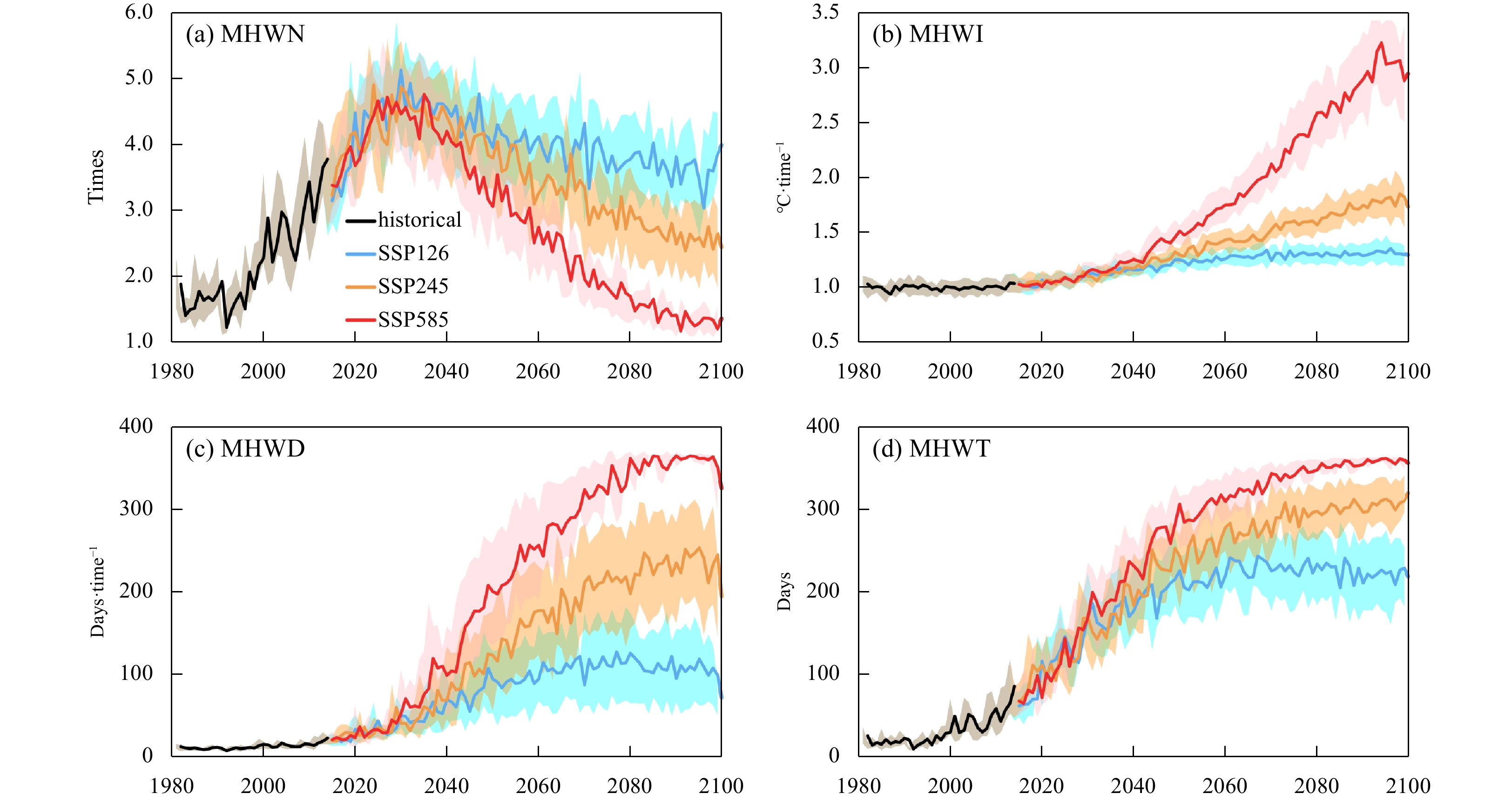
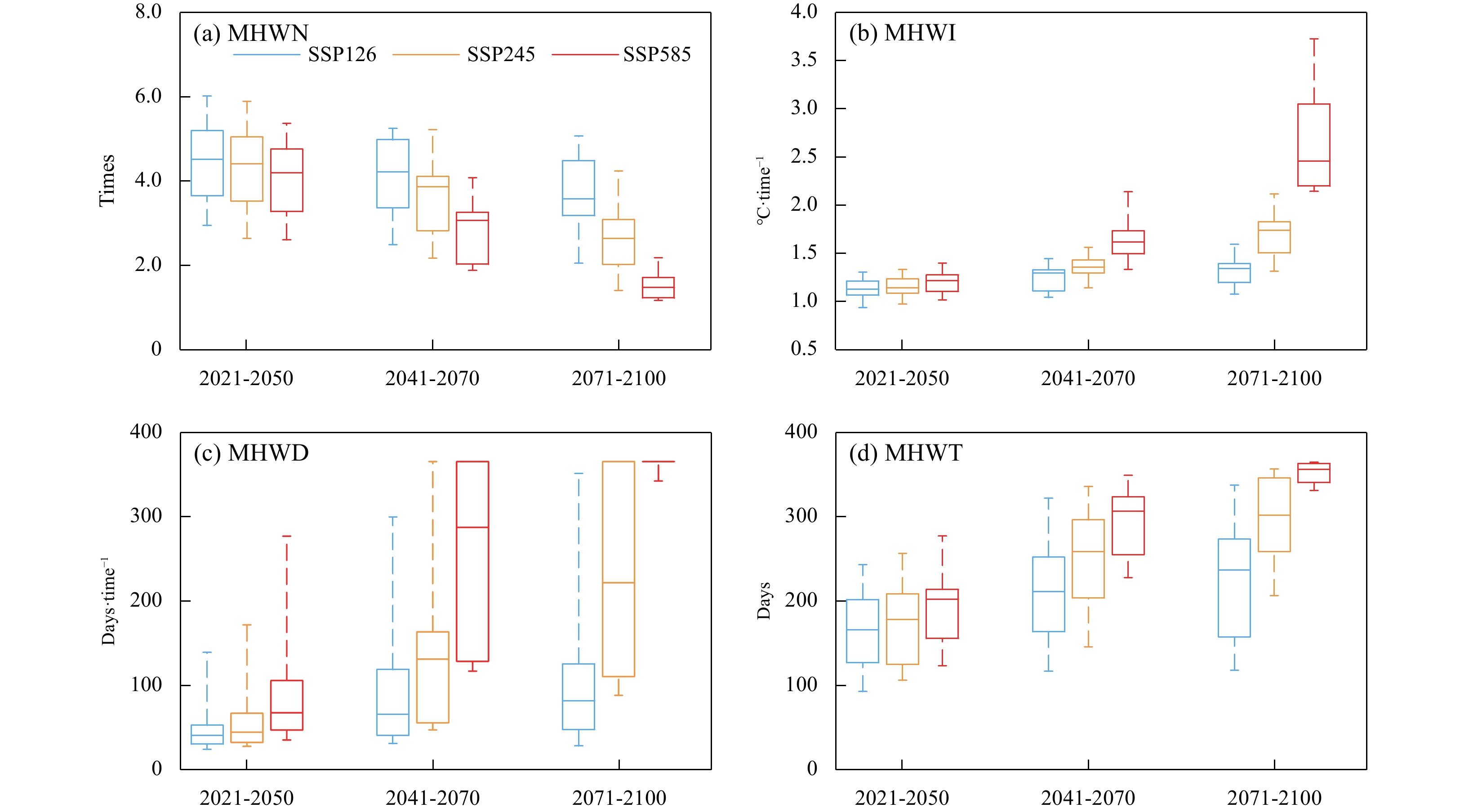
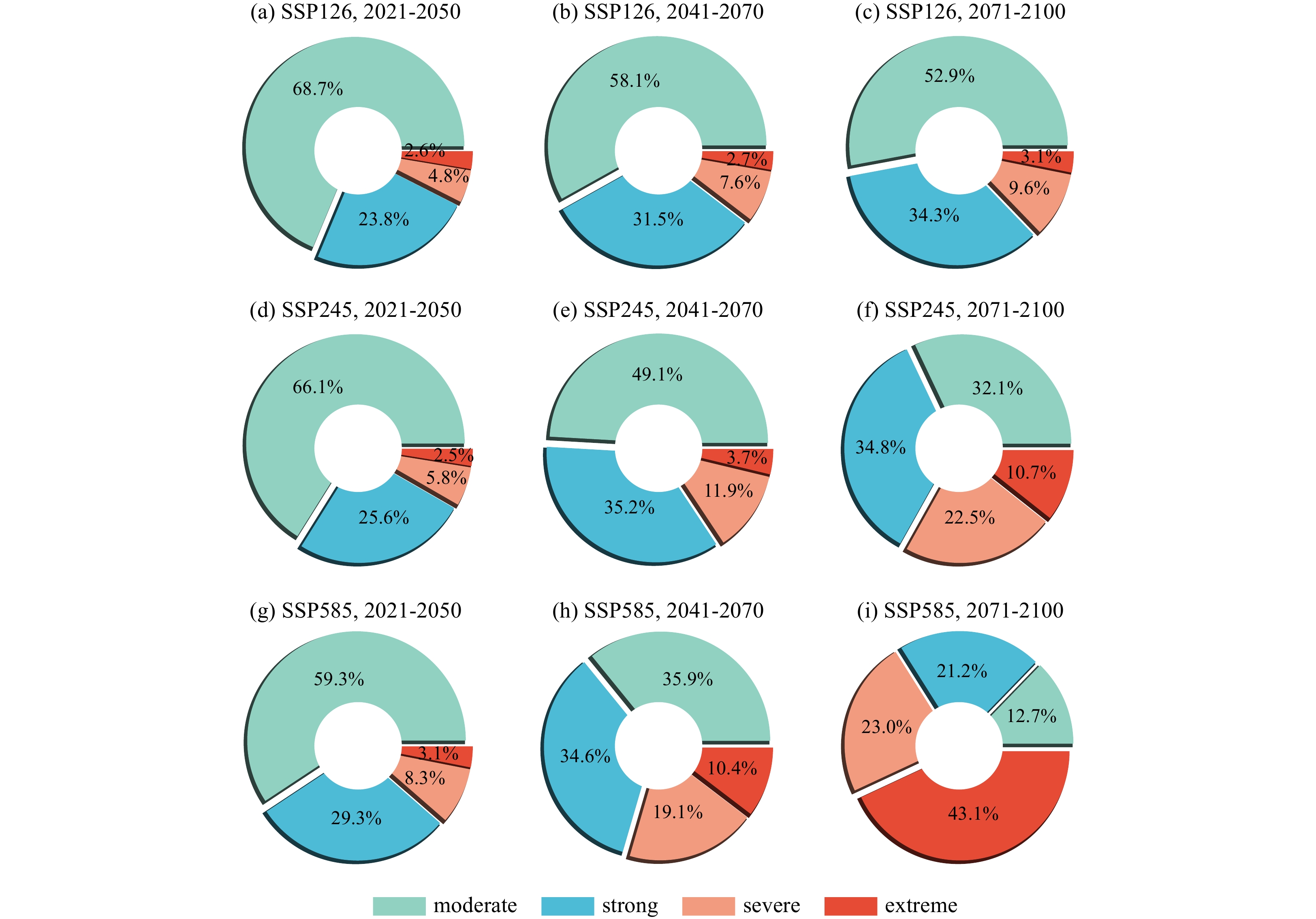
, Available online ,
doi: 10.1007/s13131-023-2267-6
Abstract:
Marine sediments were collected from the Pearl River Estuary (PRE) and South China Sea (SCS) to study the occurrence and spatial distribution of tetrabromobisphenol A (TBBPA) and hexabromocyclododecane (HBCDD). The levels of TBBPA and HBCDD in sediments ranged from not detected (nd) to 6.14 ng/g dry weight (dw) and nd to 0.42 ng/g dw. TBBPA concentrations in marine sediments were substantially higher than HBCDD. The concentrations of TBBPA and HBCDD in the PRE sediments were significantly greater than those in the SCS. α-HBCDD (48.7%) and γ-HBCDD (46.2%) were the two main diastereoisomers of HBCDD in sediments from the PRE, with minor contribution of β-HBCDD (5.1%). HBCDD were only found in one sample from the northern SCS. The enantiomeric fraction of α-HBCDD in sediments from the PRE was obviously greater than 0.5, indicating an accumulation of (+)-α-HBCDD. The enantiomers of HBCDD were not measured in sediments from the SCS. This work highlighted the environmental behaviors of TBBPA and HBCDD in marine sediments.
Marine sediments were collected from the Pearl River Estuary (PRE) and South China Sea (SCS) to study the occurrence and spatial distribution of tetrabromobisphenol A (TBBPA) and hexabromocyclododecane (HBCDD). The levels of TBBPA and HBCDD in sediments ranged from not detected (nd) to 6.14 ng/g dry weight (dw) and nd to 0.42 ng/g dw. TBBPA concentrations in marine sediments were substantially higher than HBCDD. The concentrations of TBBPA and HBCDD in the PRE sediments were significantly greater than those in the SCS. α-HBCDD (48.7%) and γ-HBCDD (46.2%) were the two main diastereoisomers of HBCDD in sediments from the PRE, with minor contribution of β-HBCDD (5.1%). HBCDD were only found in one sample from the northern SCS. The enantiomeric fraction of α-HBCDD in sediments from the PRE was obviously greater than 0.5, indicating an accumulation of (+)-α-HBCDD. The enantiomers of HBCDD were not measured in sediments from the SCS. This work highlighted the environmental behaviors of TBBPA and HBCDD in marine sediments.

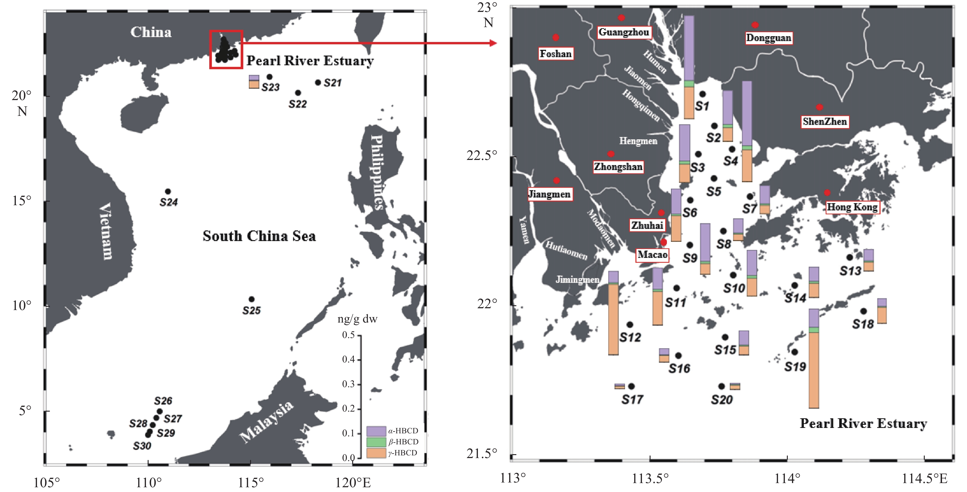
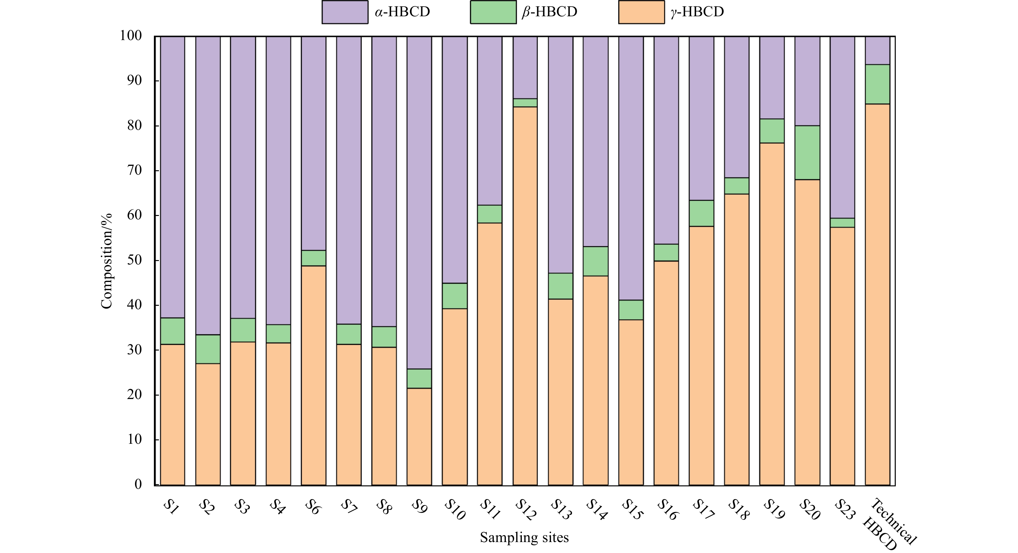
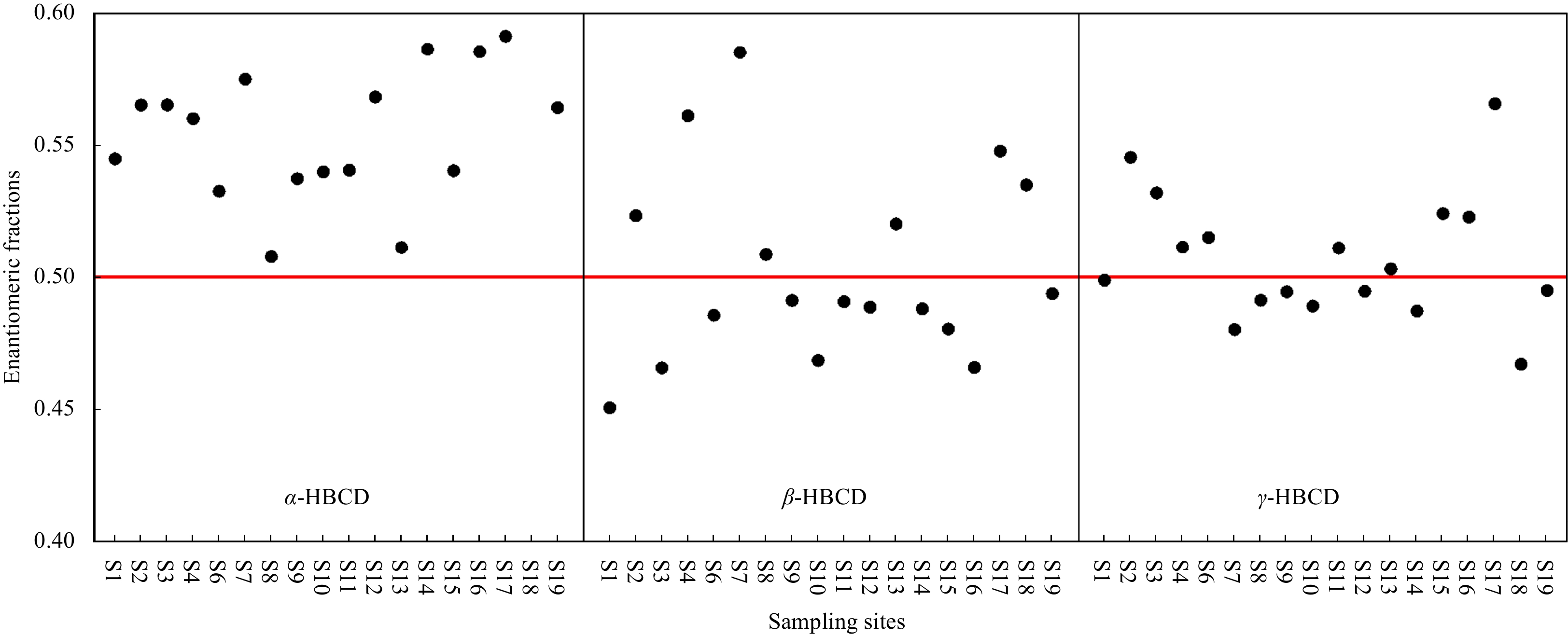
, Available online ,
doi: 10.1007/s13131-022-2131-0
Abstract:
, Available online
Abstract:
Seasonal location and intensity changes in the western Pacific subtropical high (WPSH) are important factors dominating the synoptic weather and the distribution and magnitude of precipitation in the rain belt over East Asia. Therefore, this article delves into the forecast of the western Pacific subtropical high index during typhoon activity by adopting a hybrid deep learning model. Firstly, the predictors, which are the inputs of the model, are analysed based on three characteristics: the first is the statistical discipline of the WPSH index anomalies corresponding to the three types of typhoon paths; the second is the correspondence of distributions between sea surface temperature (SST), 850 hPa zonal wind (u), meridional wind (v), and 500 hPa potential height field; and the third is the numerical sensitivity experiment, which reflects the evident impact of variations in the physical field around the typhoon to the WPSH index. Secondly, the model is repeatedly trained through the backward propagation algorithm to predict the WPSH index using 2011-2018 atmospheric variables as the input of the training set. The model predicts the WPSH index after 6 h, 24 h, 48 h, and 72 h. The validation set using independent data in 2019 is utilized to illustrate the performance. Finally, the model is improved by changing the CNN2D module to the DeCNN module to enhance its ability to predict images. Taking the 2019 Typhoon Lekima as an example, it shows the promising performance of this model to predict the 500 hPa potential height field.
Seasonal location and intensity changes in the western Pacific subtropical high (WPSH) are important factors dominating the synoptic weather and the distribution and magnitude of precipitation in the rain belt over East Asia. Therefore, this article delves into the forecast of the western Pacific subtropical high index during typhoon activity by adopting a hybrid deep learning model. Firstly, the predictors, which are the inputs of the model, are analysed based on three characteristics: the first is the statistical discipline of the WPSH index anomalies corresponding to the three types of typhoon paths; the second is the correspondence of distributions between sea surface temperature (SST), 850 hPa zonal wind (u), meridional wind (v), and 500 hPa potential height field; and the third is the numerical sensitivity experiment, which reflects the evident impact of variations in the physical field around the typhoon to the WPSH index. Secondly, the model is repeatedly trained through the backward propagation algorithm to predict the WPSH index using 2011-2018 atmospheric variables as the input of the training set. The model predicts the WPSH index after 6 h, 24 h, 48 h, and 72 h. The validation set using independent data in 2019 is utilized to illustrate the performance. Finally, the model is improved by changing the CNN2D module to the DeCNN module to enhance its ability to predict images. Taking the 2019 Typhoon Lekima as an example, it shows the promising performance of this model to predict the 500 hPa potential height field.
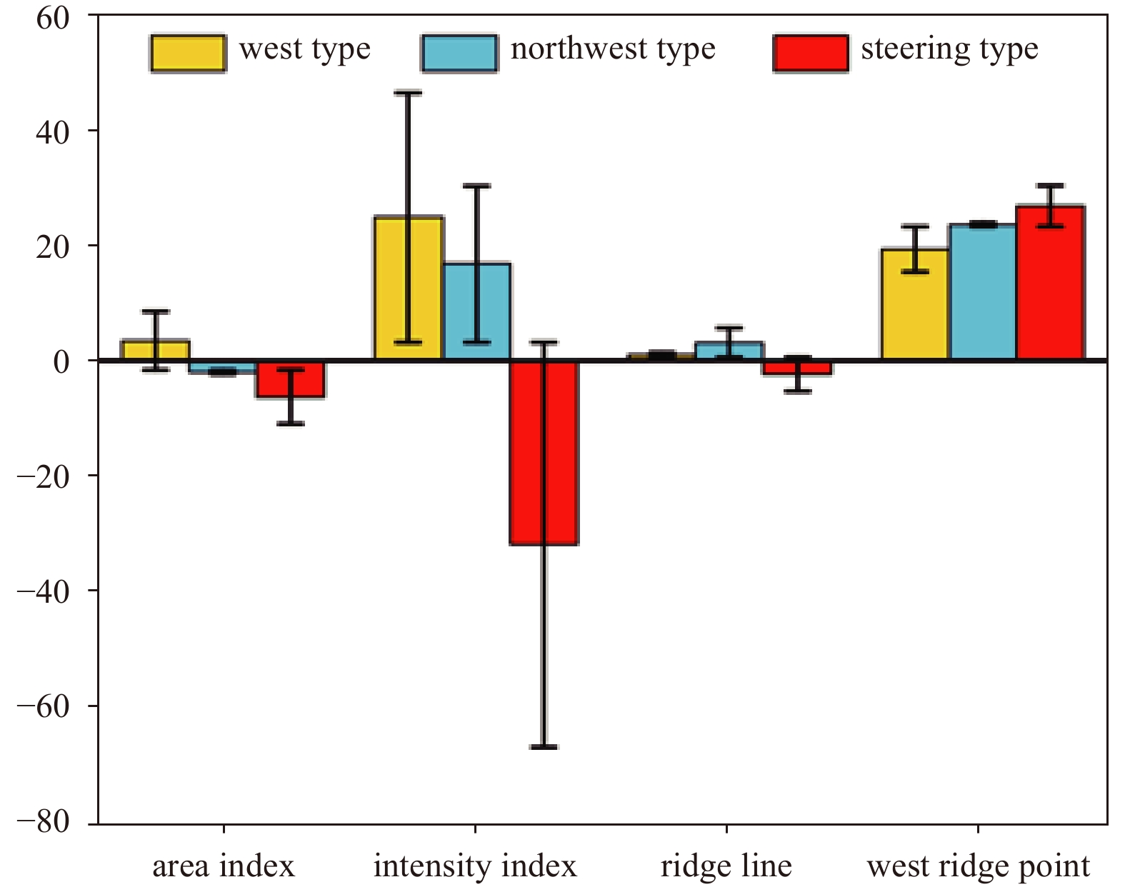


, Available online ,
doi: 10.1007/s13131-020-1589-x
Abstract:
Protease-producing bacteria play key roles in the degradation of organic nitrogen materials in marine sediments. However, their diversity, production of proteases and other extracellular enzymes, even in situ ecological functions remain largely unknown. In this study, we investigated the diversity of cultivable extracellular protease-producing bacteria in the sediments of the Bohai Bay. A total of 109 bacterial isolates were obtained from the sediments of 7 stations. The abundance of cultivable protease-producing bacteria was about 104 CFU/g of sediment in all the samples. Phylogenetic analysis based on 16S rRNA gene sequences classified all the isolates into 14 genera from phyla Proteobacteria, Firmicutes, Bacteroidetes and Actinobacteria, with Pseudoalteromonas (63/109, 57.8%), Bacillus (9/109, 8.2%), Sulfitobacter (8/109, 7.3%) and Salegentibacter (6/109, 5.5%) as the dominant taxa. Enzymatic inhibition tests indicated that all the tested isolates produced serine and/or metalloprotease, with only a small proportion producing cysteine and/or aspartic proteases. Several extracellular enzyme activities, including alginase, lipase, amylase and cellulose, and nitrate reduction were also detected for strains with higher protease activities. According the results, the protease-producing bacteria could also be participate in many biogeochemical processes in marine sediments. Our study broadened understanding and knowledge on the potential ecological functions of protease-producing bacteria in marine sediments.
Protease-producing bacteria play key roles in the degradation of organic nitrogen materials in marine sediments. However, their diversity, production of proteases and other extracellular enzymes, even in situ ecological functions remain largely unknown. In this study, we investigated the diversity of cultivable extracellular protease-producing bacteria in the sediments of the Bohai Bay. A total of 109 bacterial isolates were obtained from the sediments of 7 stations. The abundance of cultivable protease-producing bacteria was about 104 CFU/g of sediment in all the samples. Phylogenetic analysis based on 16S rRNA gene sequences classified all the isolates into 14 genera from phyla Proteobacteria, Firmicutes, Bacteroidetes and Actinobacteria, with Pseudoalteromonas (63/109, 57.8%), Bacillus (9/109, 8.2%), Sulfitobacter (8/109, 7.3%) and Salegentibacter (6/109, 5.5%) as the dominant taxa. Enzymatic inhibition tests indicated that all the tested isolates produced serine and/or metalloprotease, with only a small proportion producing cysteine and/or aspartic proteases. Several extracellular enzyme activities, including alginase, lipase, amylase and cellulose, and nitrate reduction were also detected for strains with higher protease activities. According the results, the protease-producing bacteria could also be participate in many biogeochemical processes in marine sediments. Our study broadened understanding and knowledge on the potential ecological functions of protease-producing bacteria in marine sediments.

Display Method:
2024, 43(5): 1-15.
doi: 10.1007/s13131-024-2317-8
Abstract:
A high-resolution customized numerical model is used to analyze the water transport in the three major water passages between the Andaman Sea (AS) and the Bay of Bengal, i.e., the Preparis Channel (PC), the Ten Degree Channel (TDC), and the Great Channel (GC), based on the daily averaged simulation results ranging from 2010 to 2019. Spectral analysis and Empirical Orthogonal Function (EOF) methods are employed to investigate the spatiotemporal variability of the water exchange and controlling mechanisms. The results of model simulation indicate that the net average transports of the PC and GC, as well as their linear trend, are opposite to that of the TDC. This indicates that the PC and the GC are the main inflow channels of the AS, while the TDC is the main outflow channel of the AS. The transport variability is most pronounced at surface levels and between 100 m and 200 m depth, likely affected by monsoons and circulation. A 182.4-d semiannual variability is consistently seen in all three channels, which is also evident in their second principal components. Based on sea level anomalies and EOF analysis results, this is primarily due to equatorial winds during the monsoon transition period, causing eastward movement of Kelvin waves along the AS coast, thereby affecting the spatiotemporal characteristics of the flow in the AS. The first EOF of the PC flow field section shows a split at 100 m deep, likely due to topography. The first EOF of the TDC flow field section is steady but has potent seasonal oscillations in its time series. Meanwhile, the first EOF of the GC flow field section indicates a stable surface inflow, probably influenced by the equatorial Indian Ocean’s eastward current.
A high-resolution customized numerical model is used to analyze the water transport in the three major water passages between the Andaman Sea (AS) and the Bay of Bengal, i.e., the Preparis Channel (PC), the Ten Degree Channel (TDC), and the Great Channel (GC), based on the daily averaged simulation results ranging from 2010 to 2019. Spectral analysis and Empirical Orthogonal Function (EOF) methods are employed to investigate the spatiotemporal variability of the water exchange and controlling mechanisms. The results of model simulation indicate that the net average transports of the PC and GC, as well as their linear trend, are opposite to that of the TDC. This indicates that the PC and the GC are the main inflow channels of the AS, while the TDC is the main outflow channel of the AS. The transport variability is most pronounced at surface levels and between 100 m and 200 m depth, likely affected by monsoons and circulation. A 182.4-d semiannual variability is consistently seen in all three channels, which is also evident in their second principal components. Based on sea level anomalies and EOF analysis results, this is primarily due to equatorial winds during the monsoon transition period, causing eastward movement of Kelvin waves along the AS coast, thereby affecting the spatiotemporal characteristics of the flow in the AS. The first EOF of the PC flow field section shows a split at 100 m deep, likely due to topography. The first EOF of the TDC flow field section is steady but has potent seasonal oscillations in its time series. Meanwhile, the first EOF of the GC flow field section indicates a stable surface inflow, probably influenced by the equatorial Indian Ocean’s eastward current.


2024, 43(5): 16-29.
doi: 10.1007/s13131-023-2295-x
Abstract:
The Agulhas system is the strongest western boundary current system in the Southern Hemisphere and plays an important role in modulating the Indian-to-Atlantic Ocean water exchange by the Agulhas leakage. It is difficult to measure in situ transport of the Agulhas leakage as well as the Agulhas retroflection position due to their intermittent nature. In this study, an innovative kinematic algorithm was designed and applied to the gridded altimeter observational data, to ascertain the longitudinal position of Agulhas retroflection, the stability of Agulhas jet stream, as well as its strength. The results show that the east-west shift of retroflection is related neither to the strength of Agulhas current nor to its stability. Further analysis uncovers the connection between the westward extension of Agulhas jet stream and an anomalous cyclonic circulation at its northern side, which is likely attributed to the local wind stress curl anomaly. To confirm the effect of local wind forcing on the east-west shift of retroflection, numerical sensitivity experiments were conducted. The results show that the local wind stress can induce a similar longitudinal shift of the retroflection as altimetry observations. Further statistical and case study indicates that whether an Agulhas ring can continuously migrate westward to the Atlantic Ocean or re-merge into the main flow depends on the retroflection position. Therefore, the westward retroflection may contribute to a stronger Agulhas leakage than the eastward retroflection.
The Agulhas system is the strongest western boundary current system in the Southern Hemisphere and plays an important role in modulating the Indian-to-Atlantic Ocean water exchange by the Agulhas leakage. It is difficult to measure in situ transport of the Agulhas leakage as well as the Agulhas retroflection position due to their intermittent nature. In this study, an innovative kinematic algorithm was designed and applied to the gridded altimeter observational data, to ascertain the longitudinal position of Agulhas retroflection, the stability of Agulhas jet stream, as well as its strength. The results show that the east-west shift of retroflection is related neither to the strength of Agulhas current nor to its stability. Further analysis uncovers the connection between the westward extension of Agulhas jet stream and an anomalous cyclonic circulation at its northern side, which is likely attributed to the local wind stress curl anomaly. To confirm the effect of local wind forcing on the east-west shift of retroflection, numerical sensitivity experiments were conducted. The results show that the local wind stress can induce a similar longitudinal shift of the retroflection as altimetry observations. Further statistical and case study indicates that whether an Agulhas ring can continuously migrate westward to the Atlantic Ocean or re-merge into the main flow depends on the retroflection position. Therefore, the westward retroflection may contribute to a stronger Agulhas leakage than the eastward retroflection.


2024, 43(5): 30-40.
doi: 10.1007/s13131-024-2323-x
Abstract:
Except for conventional mesoscale eddies, there are also abundant warm cyclonic eddies (WCEs) and cold anticyclonic eddies (CAEs) in the global ocean. Based on the global mesoscale eddy trajectory atlas product, satellite altimetric and remote sensing datasets, and three-dimensional temperature/salinity dataset, spatiotemporal features of WCEs and CAEs are compared with traditional cold cyclonic eddies and warm anticyclonic eddies in the Kuroshio Extension (KE; 28°−43°N, 140°−170°E) region. Characteristics of abnormal eddies like radius, amplitude, eddy kinetic energy, and proportion in all eddies behave in significant asymmetry on the north and south sides of the KE jet. Unlike eddies in the general sense, temporal feature analysis reveals that it is more favorable to the formation and maintenance of WCEs and CAEs in summer and autumn, while winter is the opposite. The spatiotemporal variation of abnormal eddies is likely because the marine environment varying with time and space. Statistically, proportion of abnormal eddies increases rapidly in decaying stage during the whole eddy lifespan, resulting in smaller average radius, amplitude, sea surface temperature anomaly and sea surface height anomaly compared to normal ones. The three-dimensional composite structures for four types of eddies expose that the difference between abnormal and conventional eddies is not just limited to the sea surface, but also exists within the water below the sea surface. Vertical structures also indicate that the anomalous temperature signal is confined in the water from the sea surface to layers at about 30 m in the KE region.
Except for conventional mesoscale eddies, there are also abundant warm cyclonic eddies (WCEs) and cold anticyclonic eddies (CAEs) in the global ocean. Based on the global mesoscale eddy trajectory atlas product, satellite altimetric and remote sensing datasets, and three-dimensional temperature/salinity dataset, spatiotemporal features of WCEs and CAEs are compared with traditional cold cyclonic eddies and warm anticyclonic eddies in the Kuroshio Extension (KE; 28°−43°N, 140°−170°E) region. Characteristics of abnormal eddies like radius, amplitude, eddy kinetic energy, and proportion in all eddies behave in significant asymmetry on the north and south sides of the KE jet. Unlike eddies in the general sense, temporal feature analysis reveals that it is more favorable to the formation and maintenance of WCEs and CAEs in summer and autumn, while winter is the opposite. The spatiotemporal variation of abnormal eddies is likely because the marine environment varying with time and space. Statistically, proportion of abnormal eddies increases rapidly in decaying stage during the whole eddy lifespan, resulting in smaller average radius, amplitude, sea surface temperature anomaly and sea surface height anomaly compared to normal ones. The three-dimensional composite structures for four types of eddies expose that the difference between abnormal and conventional eddies is not just limited to the sea surface, but also exists within the water below the sea surface. Vertical structures also indicate that the anomalous temperature signal is confined in the water from the sea surface to layers at about 30 m in the KE region.


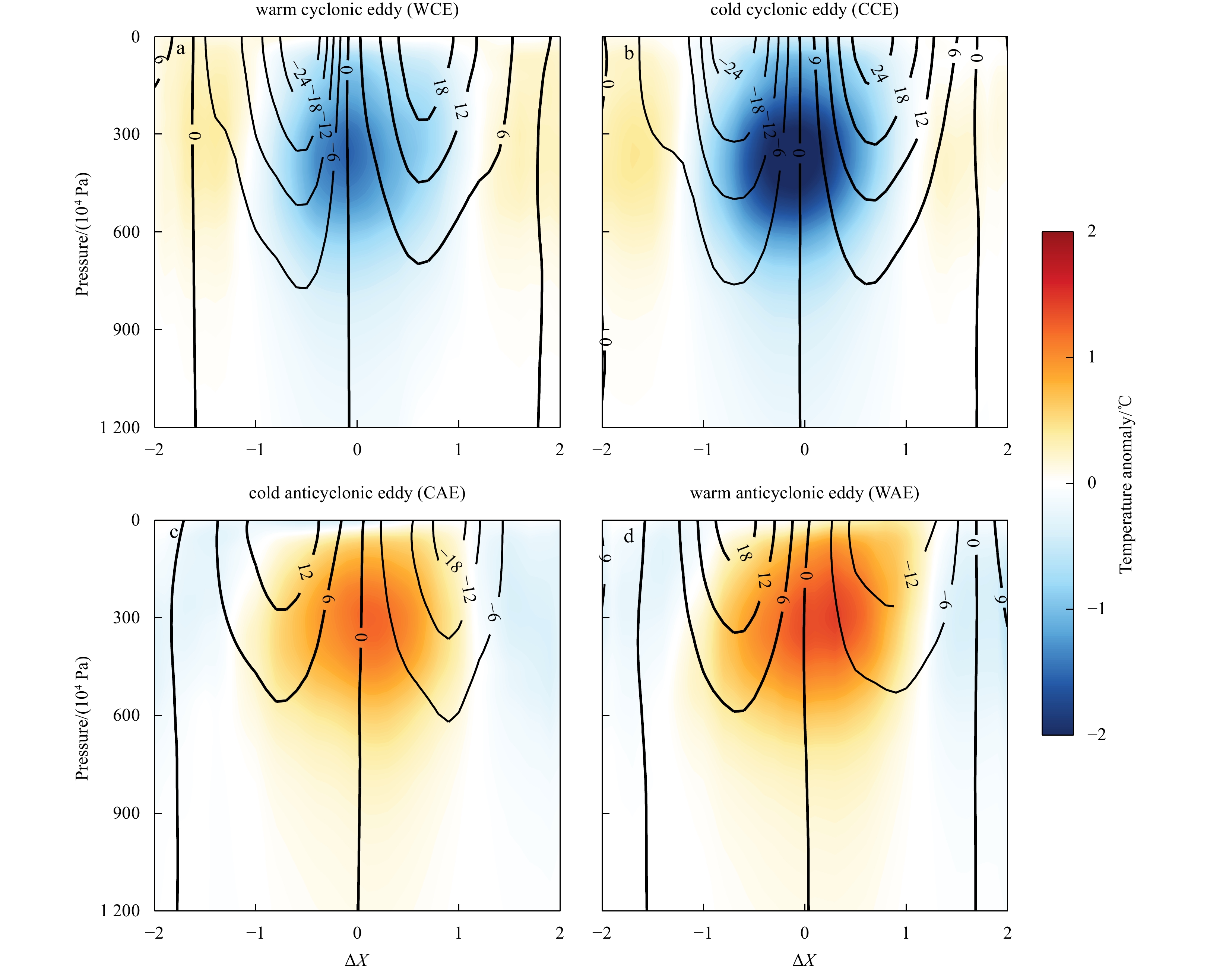
2024, 43(5): 41-53.
doi: 10.1007/s13131-023-2299-6
Abstract:
Estimated ocean subsurface fields derived from satellite observations provide potential data sources for operational marine environmental monitoring and prediction systems. This study employs a statistic regression reconstruction method, in combination with domestic autonomous sea surface height and sea surface temperature observations from the Haiyang-2 (HY-2) satellite fusion data, to establish an operational quasi-real-time three-dimensional (3D) temperature and salinity products over the Maritime Silk Road. These products feature a daily temporal resolution and a spatial resolution of 0.25° × 0.25° and exhibit stability and continuity. We have demonstrated the accuracy of the reconstructed thermohaline fields in capturing the 3D thermohaline variations through comprehensive statistical evaluations, after comparing them against Argo observations and ocean analysis data from 2022. The results illustrate that the reconstructed fields effectively represent seasonal variations in oceanic subsurface structures, along with structural changes resulting from mesoscale processes, and the upper ocean’s responses to tropical cyclones. Furthermore, the incorporation of HY-2 satellite observations notably enhances the accuracy of temperature and salinity reconstructions in the Northwest Pacific Ocean and marginally improves salinity reconstruction accuracy in the North Indian Ocean when compared to the World Ocean Atlas 2018 monthly climatology thermohaline fields. As a result, the reconstructed product holds promise for providing quasi-real-time 3D temperature and salinity field information to facilitate fast decision-making during emergencies, and also offers foundational thermohaline fields for operational ocean reanalysis and forecasting systems. These contributions enhance the safety and stability of ocean subsurface activities and navigation.
Estimated ocean subsurface fields derived from satellite observations provide potential data sources for operational marine environmental monitoring and prediction systems. This study employs a statistic regression reconstruction method, in combination with domestic autonomous sea surface height and sea surface temperature observations from the Haiyang-2 (HY-2) satellite fusion data, to establish an operational quasi-real-time three-dimensional (3D) temperature and salinity products over the Maritime Silk Road. These products feature a daily temporal resolution and a spatial resolution of 0.25° × 0.25° and exhibit stability and continuity. We have demonstrated the accuracy of the reconstructed thermohaline fields in capturing the 3D thermohaline variations through comprehensive statistical evaluations, after comparing them against Argo observations and ocean analysis data from 2022. The results illustrate that the reconstructed fields effectively represent seasonal variations in oceanic subsurface structures, along with structural changes resulting from mesoscale processes, and the upper ocean’s responses to tropical cyclones. Furthermore, the incorporation of HY-2 satellite observations notably enhances the accuracy of temperature and salinity reconstructions in the Northwest Pacific Ocean and marginally improves salinity reconstruction accuracy in the North Indian Ocean when compared to the World Ocean Atlas 2018 monthly climatology thermohaline fields. As a result, the reconstructed product holds promise for providing quasi-real-time 3D temperature and salinity field information to facilitate fast decision-making during emergencies, and also offers foundational thermohaline fields for operational ocean reanalysis and forecasting systems. These contributions enhance the safety and stability of ocean subsurface activities and navigation.

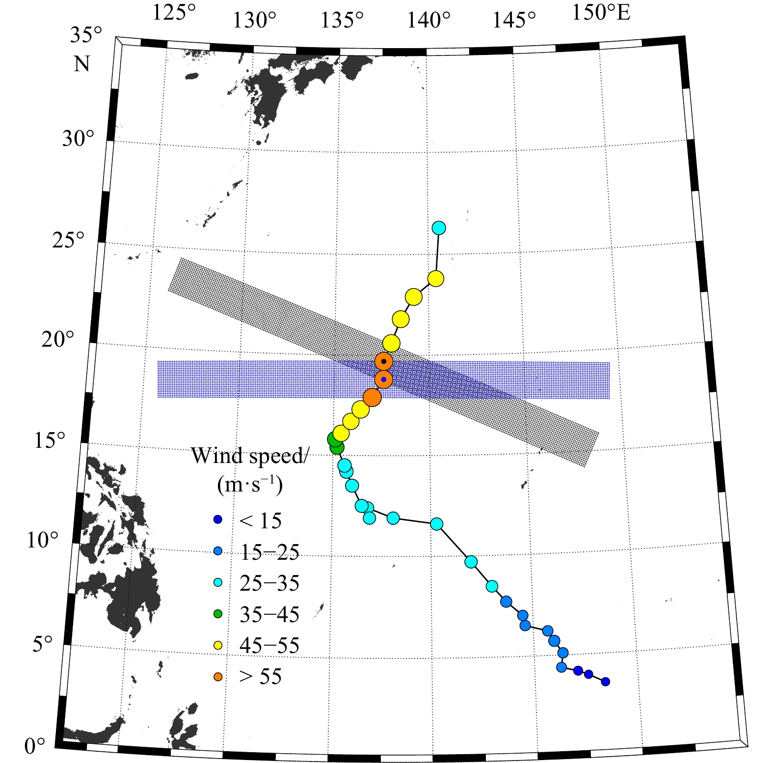

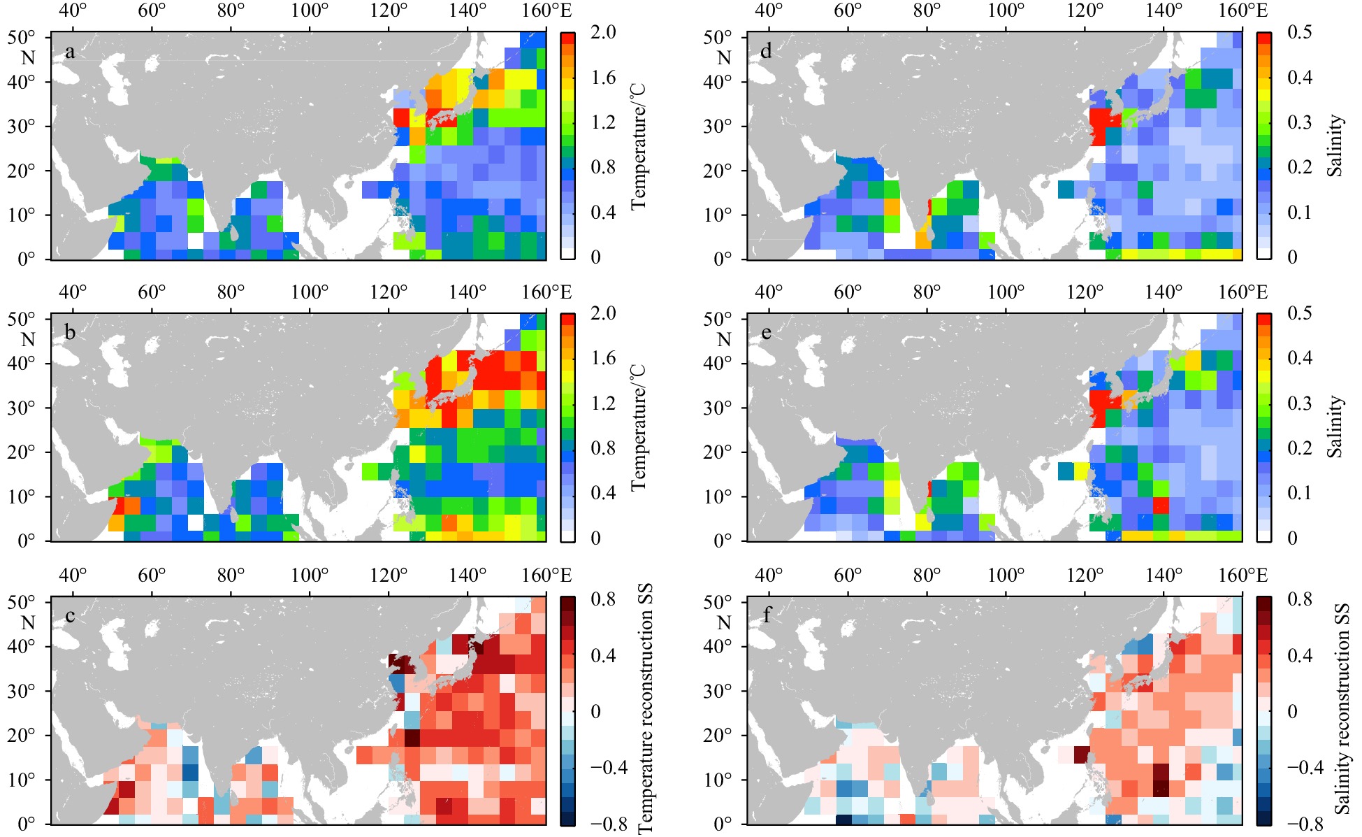


2024, 43(5): 54-64.
doi: 10.1007/s13131-024-2324-9
Abstract:
Surface Water and Ocean Topography (SWOT) is a next-generation radar altimeter that offers high resolution, wide swath, imaging capabilities. It has provided free public data worldwide since December 2023. This paper aims to preliminarily analyze the detection capabilities of the Ka-band radar interferometer (KaRIn) and Nadir altimeter (NALT), which are carried out by SWOT for internal solitary waves (ISWs), and to gather other remote sensing images to validate SWOT observations. KaRIn effectively detects ISW surface features and generates surface height variation maps reflecting the modulations induced by ISWs. However, its swath width does not completely cover the entire wave packet, and the resolution of L2/L3 level products (about 2 km) cannot be used to identify ISWs with smaller wavelengths. Additionally, significant wave height (SWH) images exhibit blocky structures that are not suitable for ISW studies; sea surface height anomaly (SSHA) images display systematic left-right banding. We optimize this imbalance using detrending methods; however, more precise treatment should commence with L1-level data. Quantitative analysis based on L3-level SSHA data indicates that the average SSHA variation induced by ISWs ranges from 10 cm to 20 cm. NALTs disturbed by ISWs record unusually elevated SWH and SSHA values, rendering the data unsuitable for analysis and necessitating targeted corrections in future retracking algorithms. For the normalized radar cross section, Ku-band and four-parameter maximum likelihood estimation retracking demonstrated greater sensitivity to minor changes in the sea surface, making them more suitable for ISW detection. In conclusion, SWOT demonstrates outstanding capabilities in ISW detection, significantly advancing research on the modulation of the sea surface by ISWs and remote sensing imaging mechanisms.
Surface Water and Ocean Topography (SWOT) is a next-generation radar altimeter that offers high resolution, wide swath, imaging capabilities. It has provided free public data worldwide since December 2023. This paper aims to preliminarily analyze the detection capabilities of the Ka-band radar interferometer (KaRIn) and Nadir altimeter (NALT), which are carried out by SWOT for internal solitary waves (ISWs), and to gather other remote sensing images to validate SWOT observations. KaRIn effectively detects ISW surface features and generates surface height variation maps reflecting the modulations induced by ISWs. However, its swath width does not completely cover the entire wave packet, and the resolution of L2/L3 level products (about 2 km) cannot be used to identify ISWs with smaller wavelengths. Additionally, significant wave height (SWH) images exhibit blocky structures that are not suitable for ISW studies; sea surface height anomaly (SSHA) images display systematic left-right banding. We optimize this imbalance using detrending methods; however, more precise treatment should commence with L1-level data. Quantitative analysis based on L3-level SSHA data indicates that the average SSHA variation induced by ISWs ranges from 10 cm to 20 cm. NALTs disturbed by ISWs record unusually elevated SWH and SSHA values, rendering the data unsuitable for analysis and necessitating targeted corrections in future retracking algorithms. For the normalized radar cross section, Ku-band and four-parameter maximum likelihood estimation retracking demonstrated greater sensitivity to minor changes in the sea surface, making them more suitable for ISW detection. In conclusion, SWOT demonstrates outstanding capabilities in ISW detection, significantly advancing research on the modulation of the sea surface by ISWs and remote sensing imaging mechanisms.


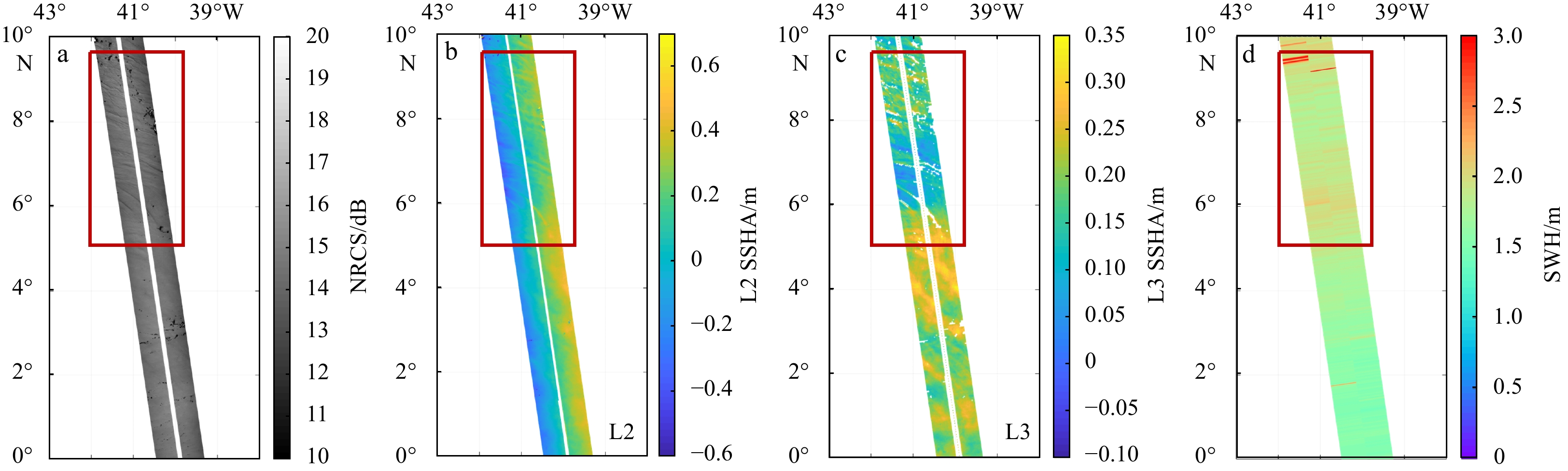


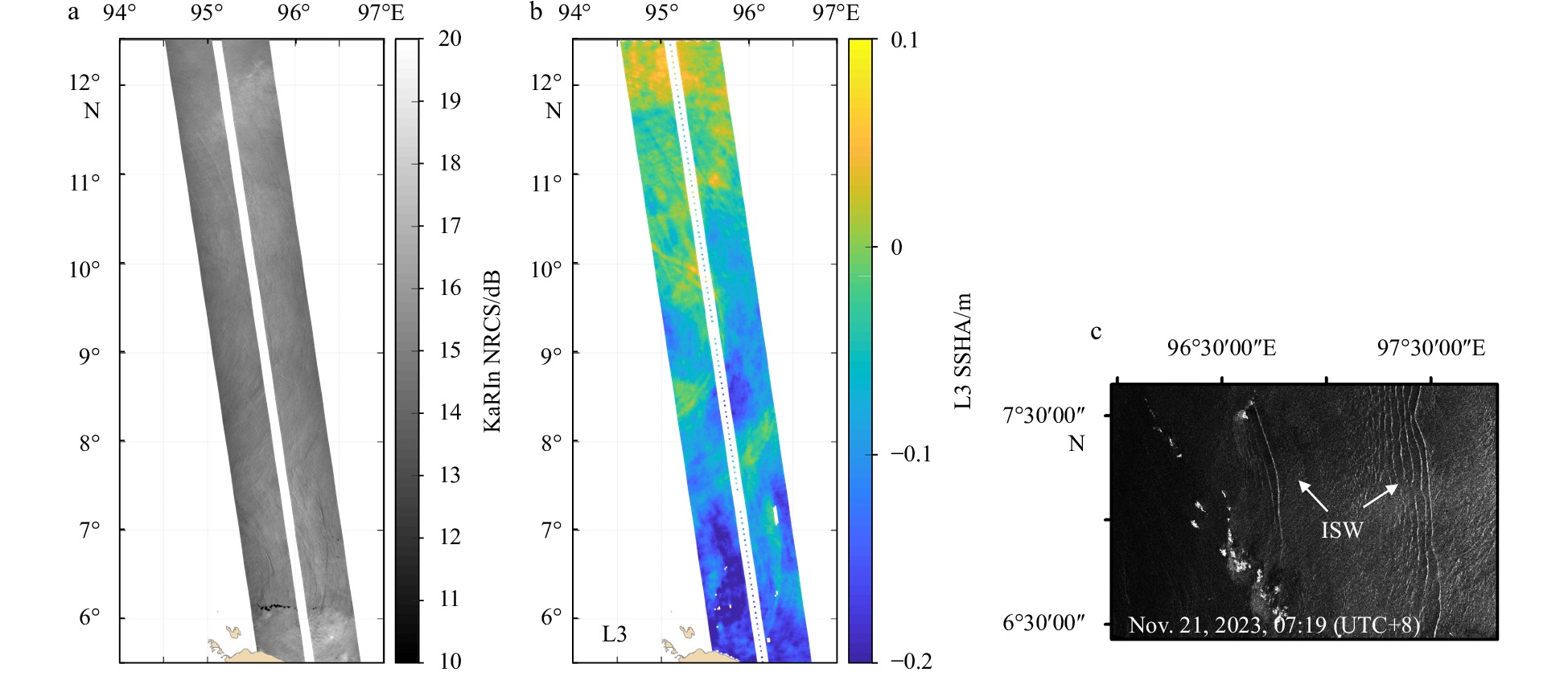
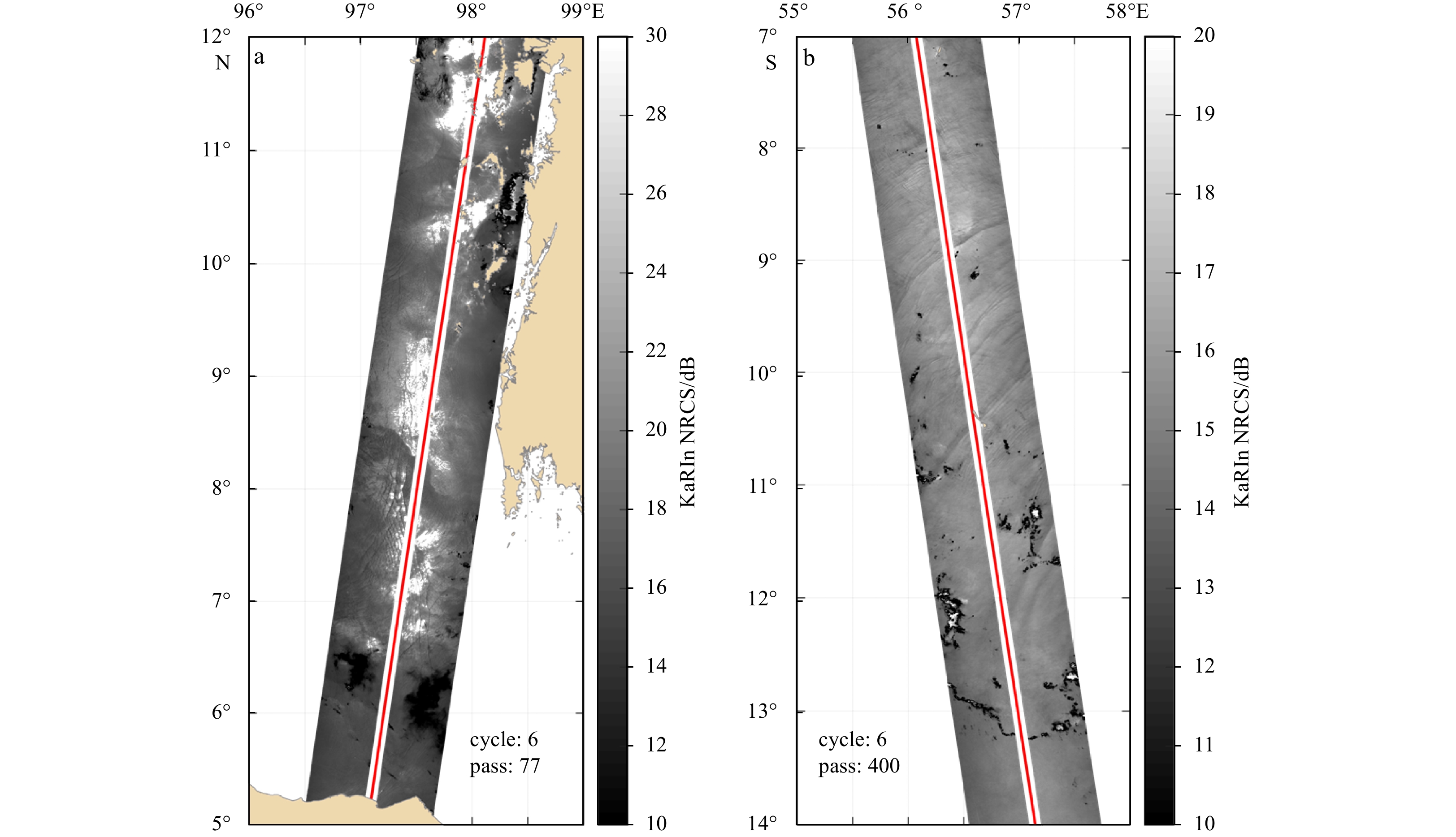

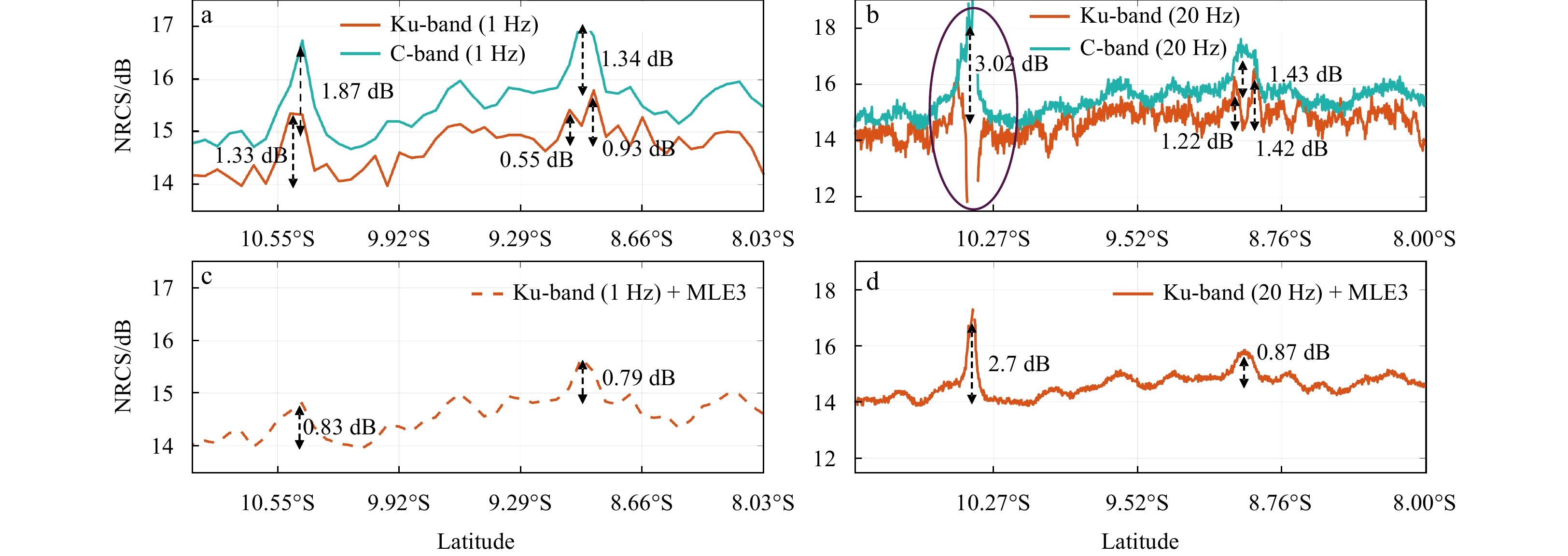
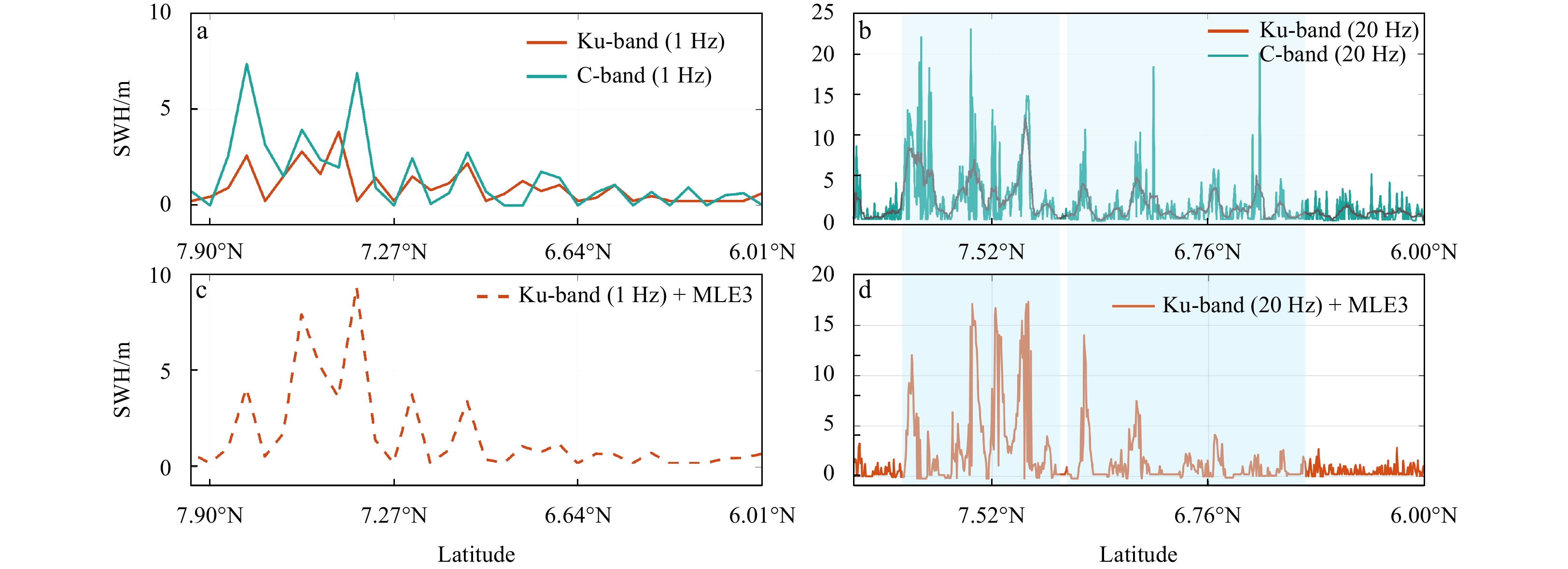


2024, 43(5): 65-77.
doi: 10.1007/s13131-024-2326-7
Abstract:
The ocean conditions beneath the ice cover play a key role in understanding the sea ice mass balance in the polar regions. An integrated high-frequency ice-ocean observation system, including Acoustic Doppler Velocimeter, Conductivity-Temperature-Depth Sensor, and Sea Ice Mass Balance Array (SIMBA), was deployed in the landfast ice region close to the Chinese Zhongshan Station in Antarctica. A sudden ocean warming of 0.14℃ (p < 0.01) was observed beneath early-frozen landfast ice, from (−1.60 ± 0.03)℃ during April 16–19 to (−1.46 ± 0.07)℃ during April 20–23, 2021, which is the only significant warming event in the nearly 8-month records. The sudden ocean warming brought a double rise in oceanic heat flux, from (21.7 ± 11.1) W/m2 during April 16–19 to (44.8 ± 21.3) W/m2 during April 20–23, 2021, which shifted the original growth phase at the ice bottom, leading to a 2 cm melting, as shown from SIMBA and borehole observations. Simultaneously, the slowdown of ice bottom freezing decreased salt rejection, and the daily trend of observed ocean salinity changed from +0.02 d−1 during April 16–19, 2021 to +0.003 d−1 during April 20–23, 2021. The potential reasons are increased air temperature due to the transit cyclones and the weakened vertical ocean mixing due to the tide phase transformation from semi-diurnal to diurnal. The high-frequency observations within the ice-ocean boundary layer enhance the comprehensive investigation of the ocean’s influence on ice evolution at a daily scale.
The ocean conditions beneath the ice cover play a key role in understanding the sea ice mass balance in the polar regions. An integrated high-frequency ice-ocean observation system, including Acoustic Doppler Velocimeter, Conductivity-Temperature-Depth Sensor, and Sea Ice Mass Balance Array (SIMBA), was deployed in the landfast ice region close to the Chinese Zhongshan Station in Antarctica. A sudden ocean warming of 0.14℃ (p < 0.01) was observed beneath early-frozen landfast ice, from (−1.60 ± 0.03)℃ during April 16–19 to (−1.46 ± 0.07)℃ during April 20–23, 2021, which is the only significant warming event in the nearly 8-month records. The sudden ocean warming brought a double rise in oceanic heat flux, from (21.7 ± 11.1) W/m2 during April 16–19 to (44.8 ± 21.3) W/m2 during April 20–23, 2021, which shifted the original growth phase at the ice bottom, leading to a 2 cm melting, as shown from SIMBA and borehole observations. Simultaneously, the slowdown of ice bottom freezing decreased salt rejection, and the daily trend of observed ocean salinity changed from +0.02 d−1 during April 16–19, 2021 to +0.003 d−1 during April 20–23, 2021. The potential reasons are increased air temperature due to the transit cyclones and the weakened vertical ocean mixing due to the tide phase transformation from semi-diurnal to diurnal. The high-frequency observations within the ice-ocean boundary layer enhance the comprehensive investigation of the ocean’s influence on ice evolution at a daily scale.


2024, 43(5): 78-90.
doi: 10.1007/s13131-023-2248-9
Abstract:
Sea ice surface roughness (SIR) affects the energy transfer between the atmosphere and the ocean, and it is also an important indicator for sea ice characteristics. To obtain a small-scale SIR with high spatial resolution, a novel method is proposed to retrieve SIR from Sentinel-1 synthetic aperture radar (SAR) images, utilizing an ensemble learning method. Firstly, the two-dimensional continuous wavelet transform is applied to obtain the spatial information of sea ice, including the scale and direction of ice patterns. Secondly, a model is developed using the Adaboost Regression model to establish a relationship among SIR, radar backscatter and the spatial information of sea ice. The proposed method is validated by using the SIR retrieved from SAR images and comparing it to the measurements obtained by the Airborne Topographic Mapper (ATM) in the summer Beaufort Sea. The determination of coefficient, mean absolute error, root-mean-square error and mean absolute percentage error of the testing data are 0.91, 1.71 cm, 2.82 cm, and 36.37%, respectively, which are reasonable. Moreover, K-fold cross-validation and learning curves are analyzed, which also demonstrate the method’s applicability in retrieving SIR from SAR images.
Sea ice surface roughness (SIR) affects the energy transfer between the atmosphere and the ocean, and it is also an important indicator for sea ice characteristics. To obtain a small-scale SIR with high spatial resolution, a novel method is proposed to retrieve SIR from Sentinel-1 synthetic aperture radar (SAR) images, utilizing an ensemble learning method. Firstly, the two-dimensional continuous wavelet transform is applied to obtain the spatial information of sea ice, including the scale and direction of ice patterns. Secondly, a model is developed using the Adaboost Regression model to establish a relationship among SIR, radar backscatter and the spatial information of sea ice. The proposed method is validated by using the SIR retrieved from SAR images and comparing it to the measurements obtained by the Airborne Topographic Mapper (ATM) in the summer Beaufort Sea. The determination of coefficient, mean absolute error, root-mean-square error and mean absolute percentage error of the testing data are 0.91, 1.71 cm, 2.82 cm, and 36.37%, respectively, which are reasonable. Moreover, K-fold cross-validation and learning curves are analyzed, which also demonstrate the method’s applicability in retrieving SIR from SAR images.


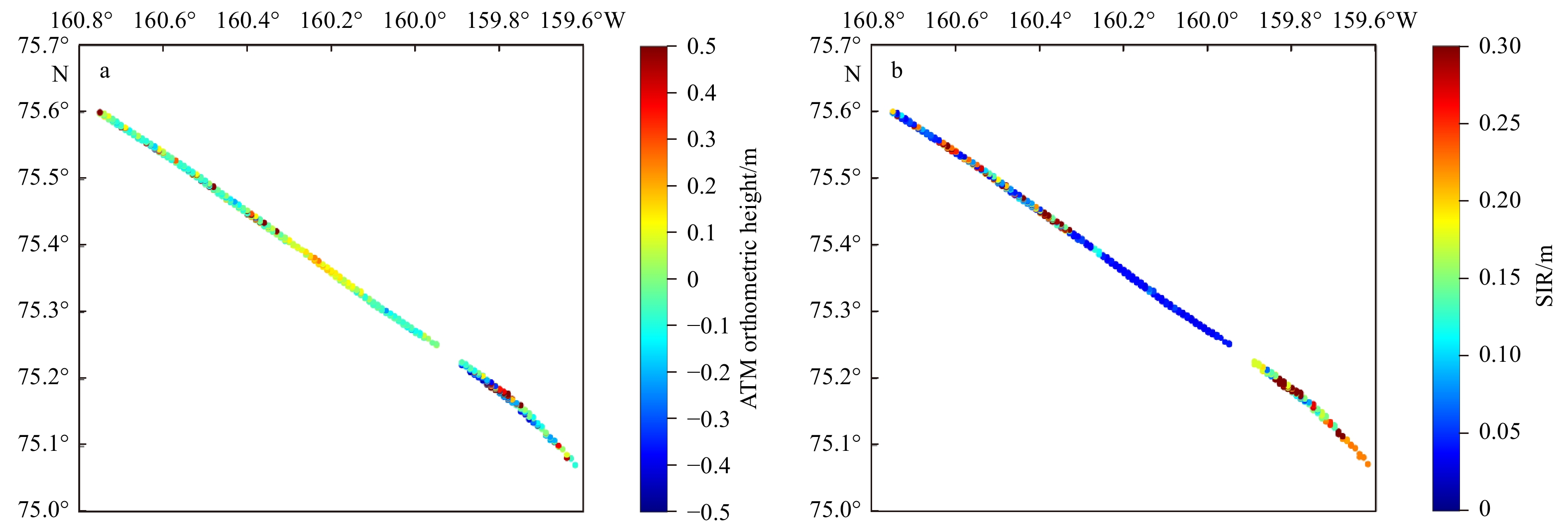

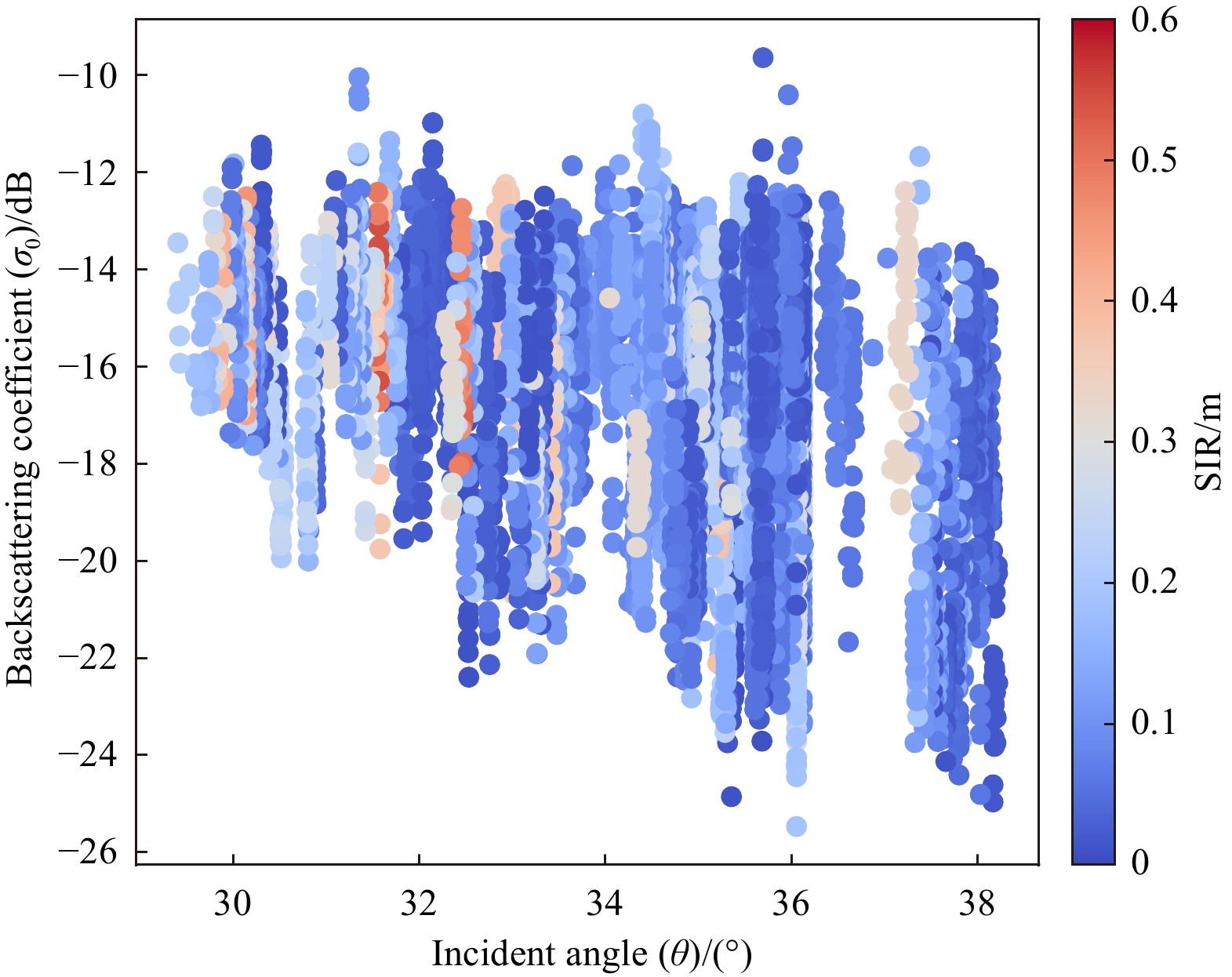


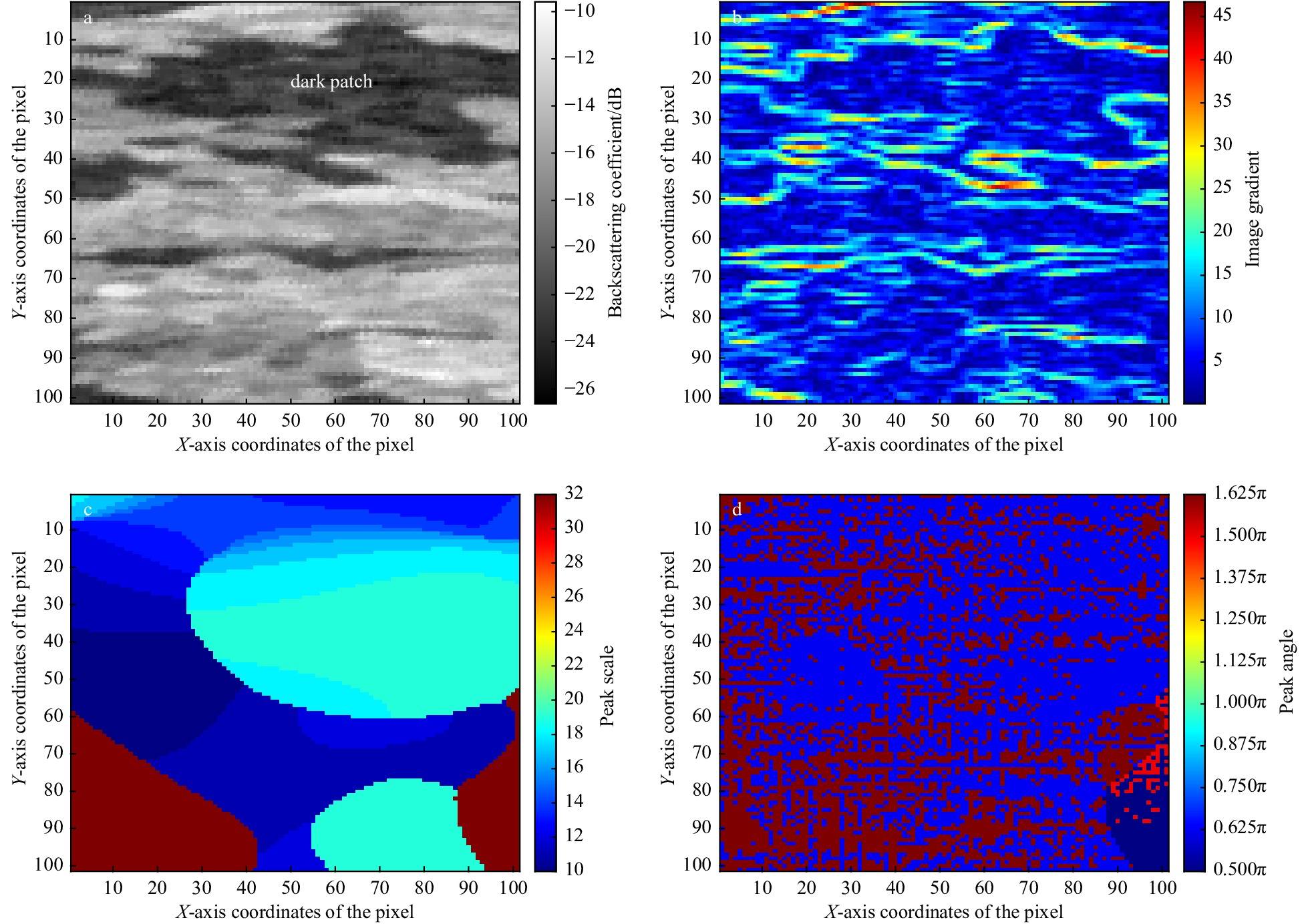
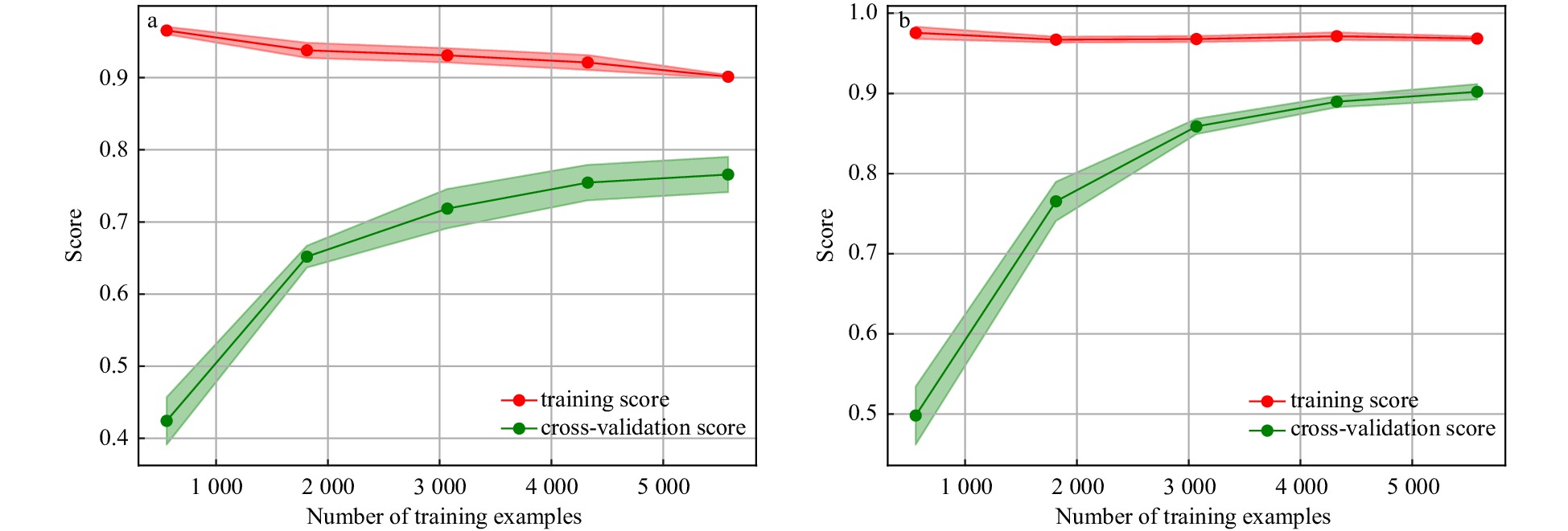
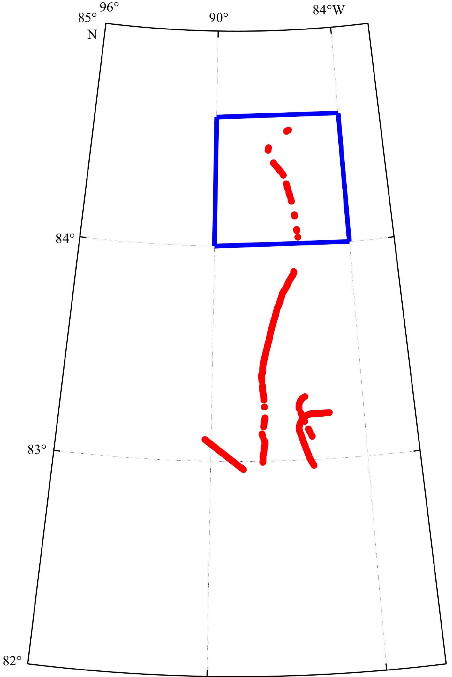
2024, 43(5): 91-99.
doi: 10.1007/s13131-024-2321-z
Abstract:
Accurate simulation of the evolution of freak waves by the wave phase focusing method requires accurate linear and nonlinear properties, especially in deep-water conditions. In this paper, we analyze the ability to simulate deep-water focused waves of a two-layer Boussinesq-type (BT) model, which has been shown to have excellent linear and nonlinear performance. To further improve the numerical accuracy and stability, the internal wave-generated method is introduced into the two-layer Boussinesq-type model. Firstly, the sensitivity of the numerical results to the grid resolution is analyzed to verify the convergence of the model; secondly, the focused wave propagating in two opposite directions is simulated to prove the symmetry of the numerical results and the feasibility of the internal wave-generated method; thirdly, the limiting focused wave condition is simulated to compare and analyze the wave surface and the horizontal velocity of the profile at the focusing position, which is in good agreement with the measured values. Meanwhile the simulation of focused waves in very deep waters agrees well with the measured values, which further demonstrates the capability of the two-layer BT model in simulating focused waves in deep waters.
Accurate simulation of the evolution of freak waves by the wave phase focusing method requires accurate linear and nonlinear properties, especially in deep-water conditions. In this paper, we analyze the ability to simulate deep-water focused waves of a two-layer Boussinesq-type (BT) model, which has been shown to have excellent linear and nonlinear performance. To further improve the numerical accuracy and stability, the internal wave-generated method is introduced into the two-layer Boussinesq-type model. Firstly, the sensitivity of the numerical results to the grid resolution is analyzed to verify the convergence of the model; secondly, the focused wave propagating in two opposite directions is simulated to prove the symmetry of the numerical results and the feasibility of the internal wave-generated method; thirdly, the limiting focused wave condition is simulated to compare and analyze the wave surface and the horizontal velocity of the profile at the focusing position, which is in good agreement with the measured values. Meanwhile the simulation of focused waves in very deep waters agrees well with the measured values, which further demonstrates the capability of the two-layer BT model in simulating focused waves in deep waters.
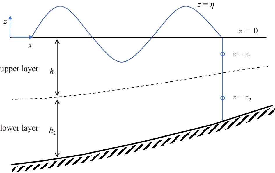
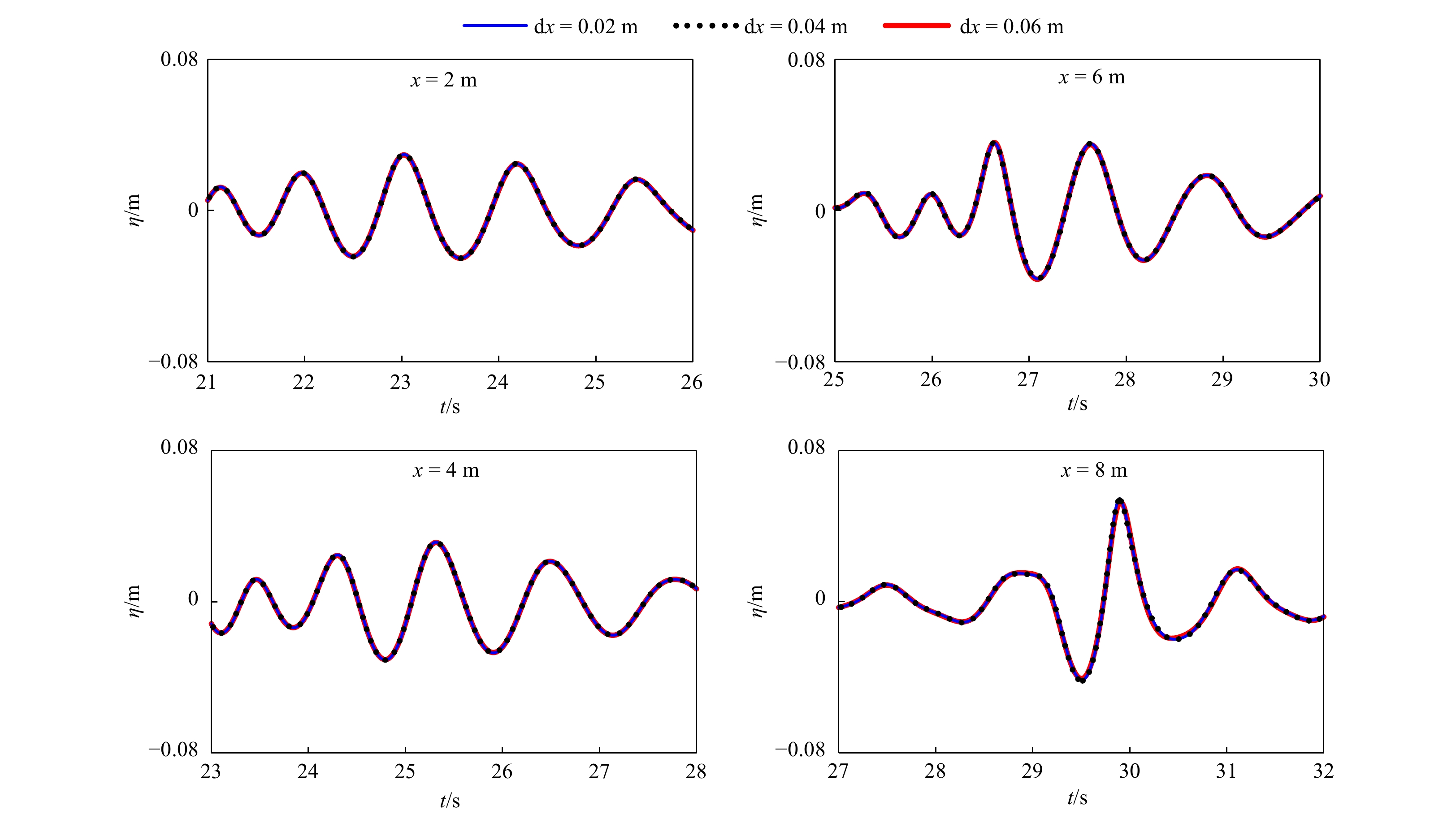


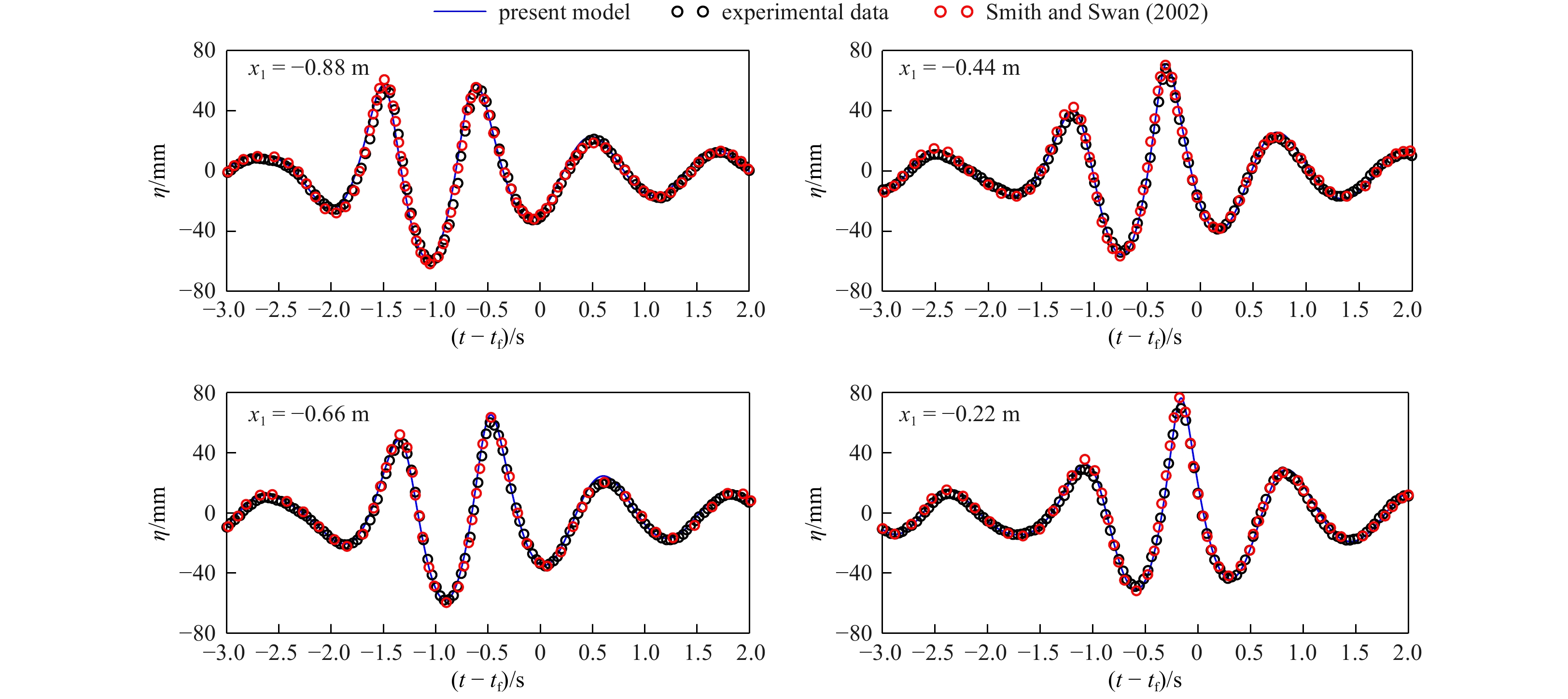
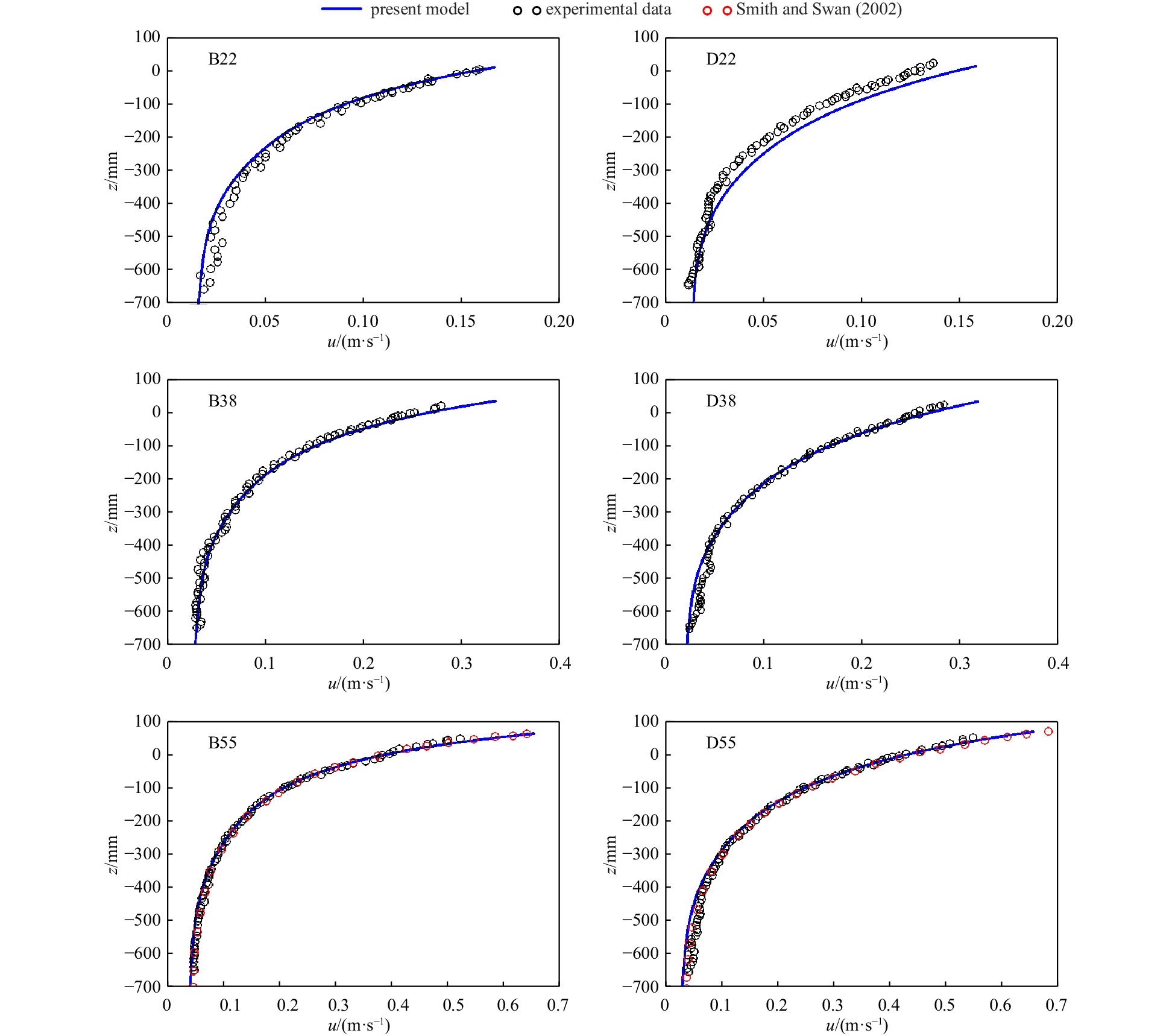

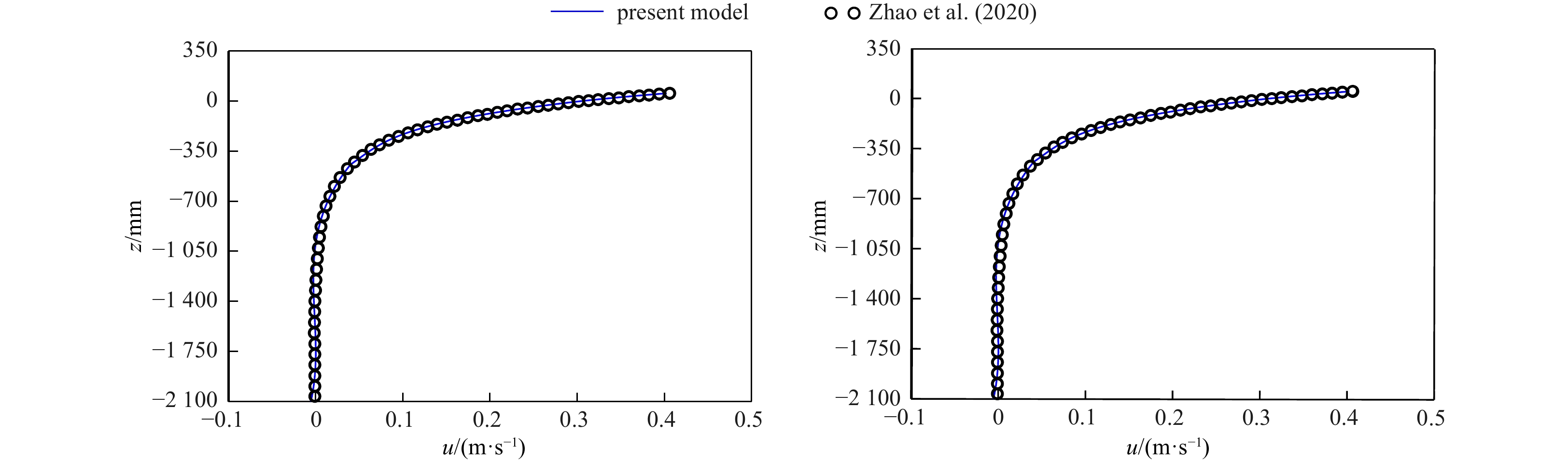
2024, 43(5): 100-109.
doi: 10.1007/s13131-024-2322-y
Abstract:
Quality control (QC) is an essential procedure in scatterometer wind retrieval, which is used to distinguish good-quality data from poor-quality wind vector cells (WVCs) for the sake of wind applications. The current wind processor of the China-France Oceanography Satellite (CFOSAT) scatterometer (CSCAT) adopts a maximum likelihood estimator (MLE)-based QC method to filter WVCs affected by geophysical noise, such as rainfall and wind variability. As the first Ku-band rotating fan-beam scatterometer, CSCAT can acquire up to 16 observations over a single WVC, giving abundant information with diverse incidence/azimuth angles, as such its MLE statistical characteristics may be different from the previous scatterometers. In this study, several QC indicators, including MLE, its spatially averaged value (MLEm), and the singularity exponents (SE), are analyzed using the collocated Global Precipitation Mission rainfall data as well as buoy data, to compare their sensitivity to rainfall and wind quality. The results show that wind error characteristics of CSCAT under different QC methods are similar to those of other Ku-band scatterometers, i.e., SE is more suitable than other parameters for the wind QC at outer-swath and nadir regions, while MLEm is the best QC indicator for the sweet region WVCs. Specifically, SE is much more favorable than others at high wind speeds. By combining different indicators, an improved QC method is developed for CSCAT. The validation with the collocated buoy data shows that it accepts more WVCs, and in turn, improves the quality control of CSCAT wind data.
Quality control (QC) is an essential procedure in scatterometer wind retrieval, which is used to distinguish good-quality data from poor-quality wind vector cells (WVCs) for the sake of wind applications. The current wind processor of the China-France Oceanography Satellite (CFOSAT) scatterometer (CSCAT) adopts a maximum likelihood estimator (MLE)-based QC method to filter WVCs affected by geophysical noise, such as rainfall and wind variability. As the first Ku-band rotating fan-beam scatterometer, CSCAT can acquire up to 16 observations over a single WVC, giving abundant information with diverse incidence/azimuth angles, as such its MLE statistical characteristics may be different from the previous scatterometers. In this study, several QC indicators, including MLE, its spatially averaged value (MLEm), and the singularity exponents (SE), are analyzed using the collocated Global Precipitation Mission rainfall data as well as buoy data, to compare their sensitivity to rainfall and wind quality. The results show that wind error characteristics of CSCAT under different QC methods are similar to those of other Ku-band scatterometers, i.e., SE is more suitable than other parameters for the wind QC at outer-swath and nadir regions, while MLEm is the best QC indicator for the sweet region WVCs. Specifically, SE is much more favorable than others at high wind speeds. By combining different indicators, an improved QC method is developed for CSCAT. The validation with the collocated buoy data shows that it accepts more WVCs, and in turn, improves the quality control of CSCAT wind data.

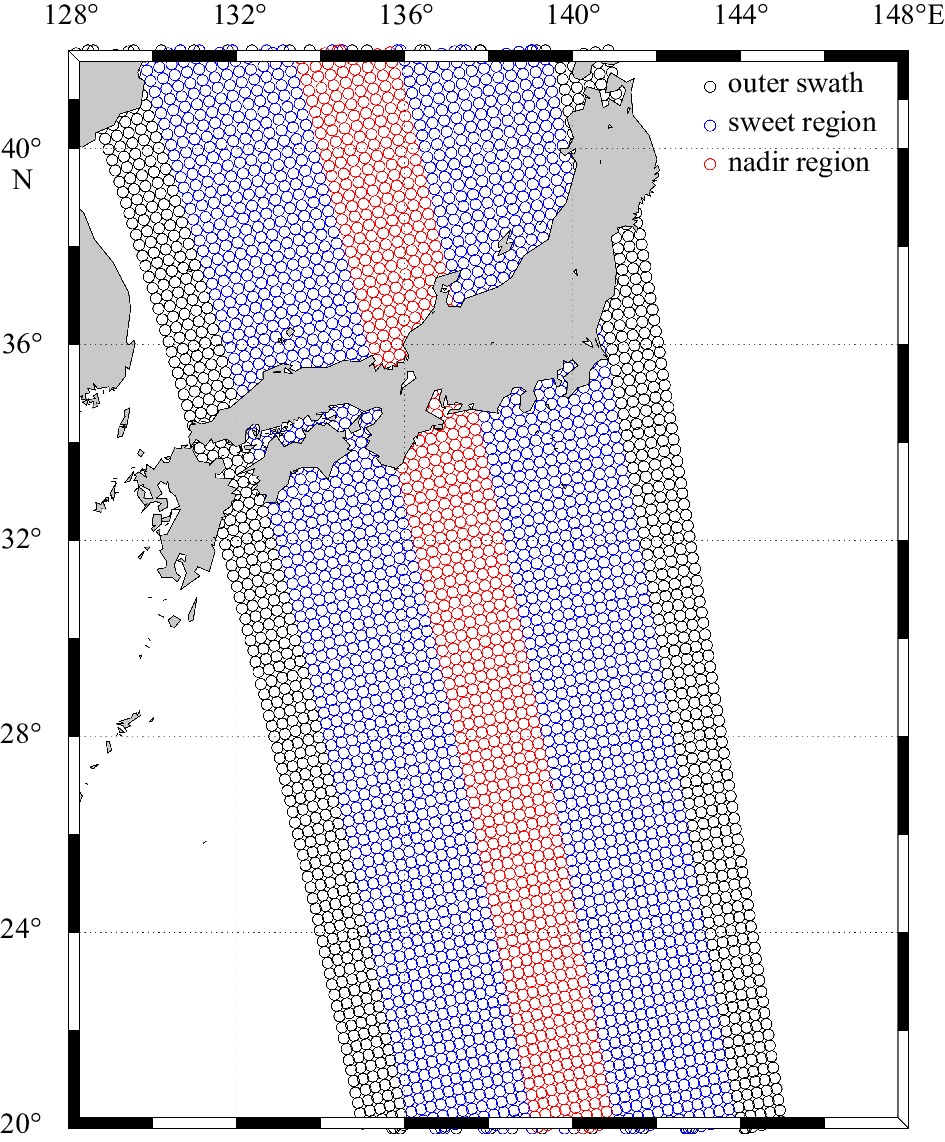


2024, 43(5): 110-120.
doi: 10.1007/s13131-024-2328-5
Abstract:
The mesoscale eddy (ME) has a significant influence on the convergence effect in deep-sea acoustic propagation. This paper use statistical approaches to express quantitative relationships between the ME conditions and convergence zone (CZ) characteristics. Based on the Gaussian vortex model, we construct various sound propagation scenarios under different eddy conditions, and carry out sound propagation experiments to obtain simulation samples. With a large number of samples, we first adopt the unified regression to set up analytic relationships between eddy conditions and CZ parameters. The sensitivity of eddy indicators to the CZ is quantitatively analyzed. Then, we adopt the machine learning (ML) algorithms to establish prediction models of CZ parameters by exploring the nonlinear relationships between multiple ME indicators and CZ parameters. Through the research, we can express the influence of ME on the CZ quantitatively, and achieve the rapid prediction of CZ parameters in ocean eddies. The prediction accuracy (R) of the CZ distance (mean R: 0.9815) is obviously better than that of the CZ width (mean R: 0.8728). Among the three ML algorithms, Gradient Boosting Decision Tree has the best prediction ability (root mean square error (RMSE): 0.136), followed by Random Forest (RMSE: 0.441) and Extreme Learning Machine (RMSE: 0.518).
The mesoscale eddy (ME) has a significant influence on the convergence effect in deep-sea acoustic propagation. This paper use statistical approaches to express quantitative relationships between the ME conditions and convergence zone (CZ) characteristics. Based on the Gaussian vortex model, we construct various sound propagation scenarios under different eddy conditions, and carry out sound propagation experiments to obtain simulation samples. With a large number of samples, we first adopt the unified regression to set up analytic relationships between eddy conditions and CZ parameters. The sensitivity of eddy indicators to the CZ is quantitatively analyzed. Then, we adopt the machine learning (ML) algorithms to establish prediction models of CZ parameters by exploring the nonlinear relationships between multiple ME indicators and CZ parameters. Through the research, we can express the influence of ME on the CZ quantitatively, and achieve the rapid prediction of CZ parameters in ocean eddies. The prediction accuracy (R) of the CZ distance (mean R: 0.9815) is obviously better than that of the CZ width (mean R: 0.8728). Among the three ML algorithms, Gradient Boosting Decision Tree has the best prediction ability (root mean square error (RMSE): 0.136), followed by Random Forest (RMSE: 0.441) and Extreme Learning Machine (RMSE: 0.518).
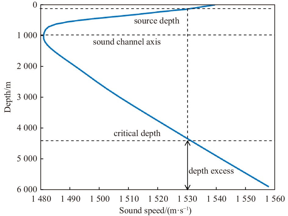
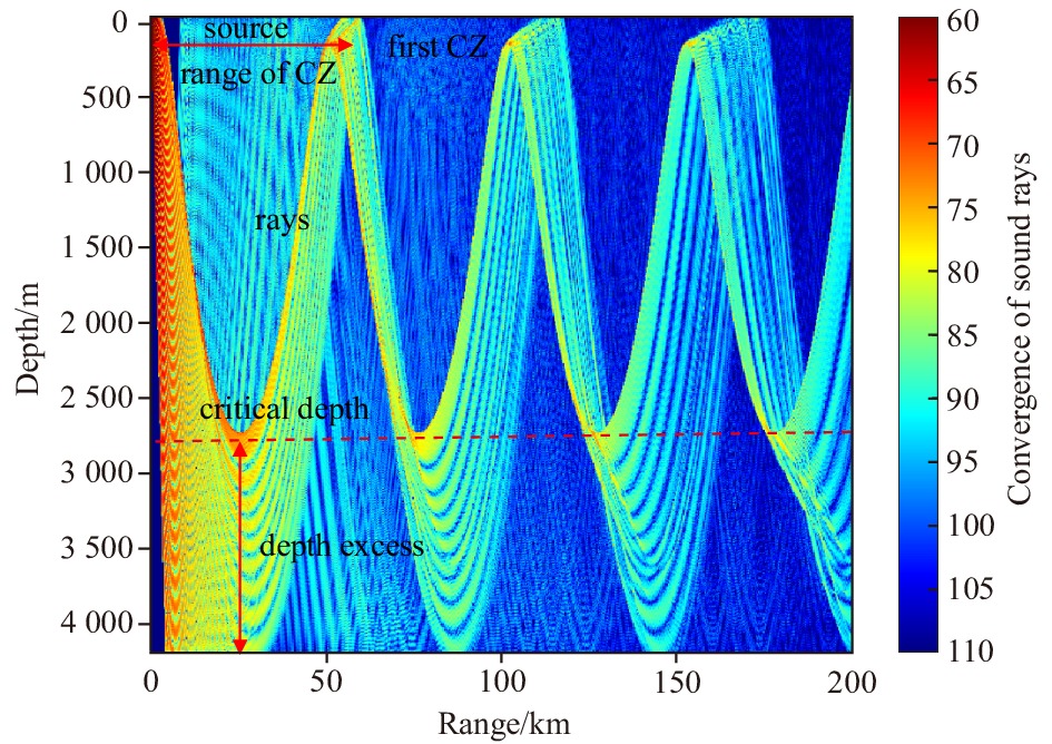
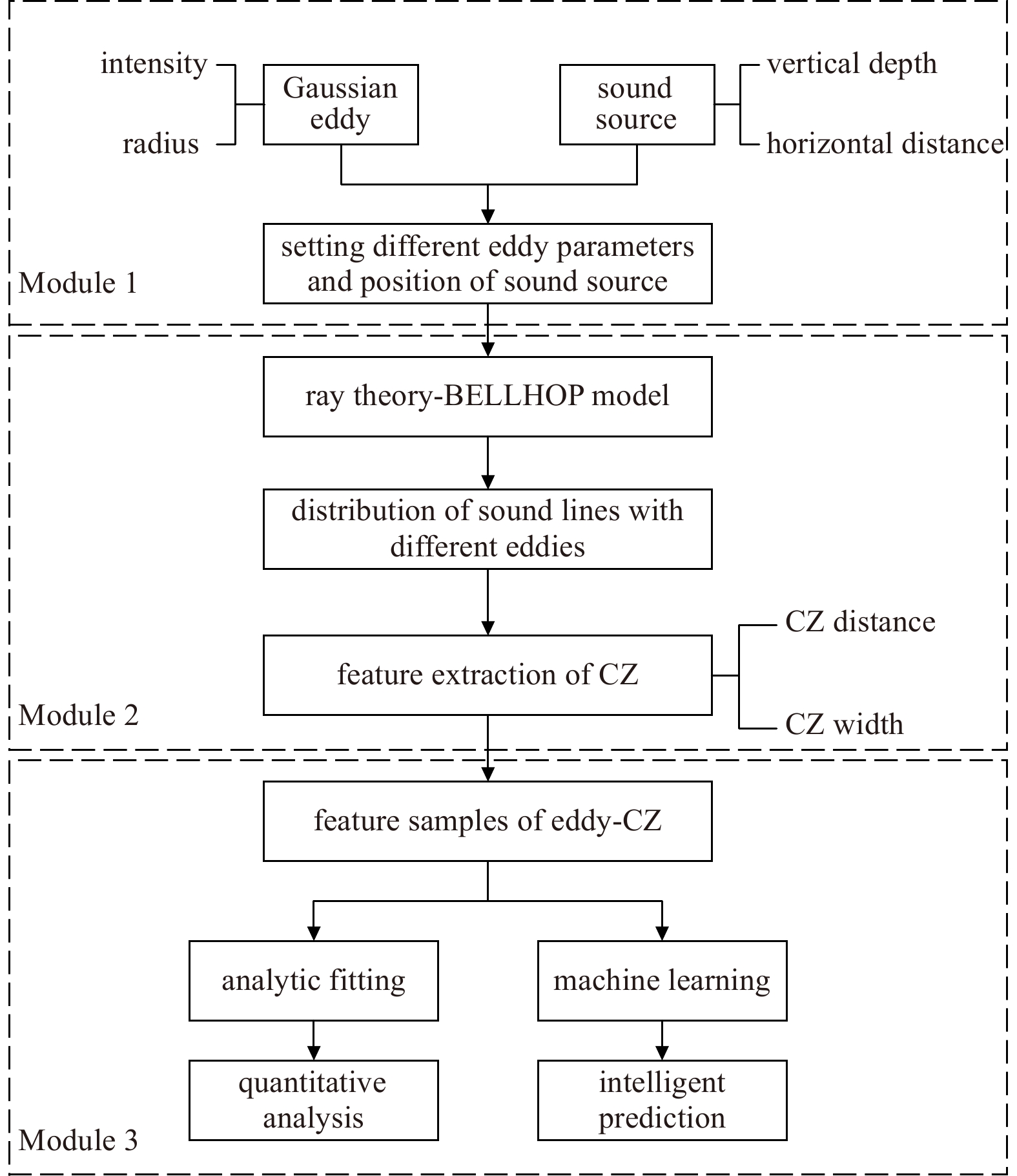
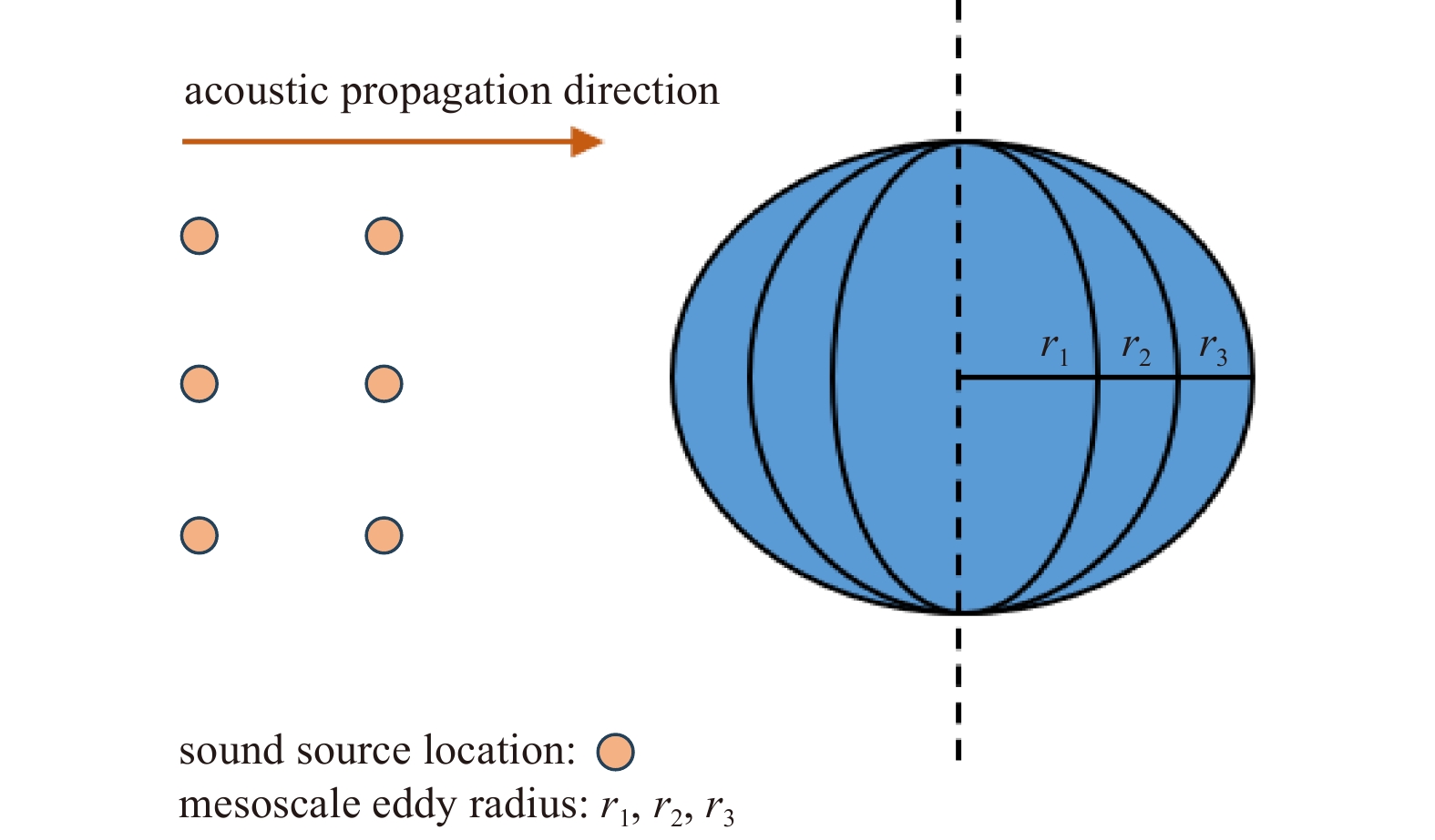

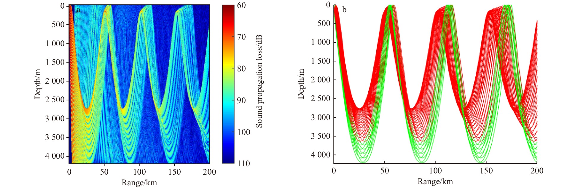
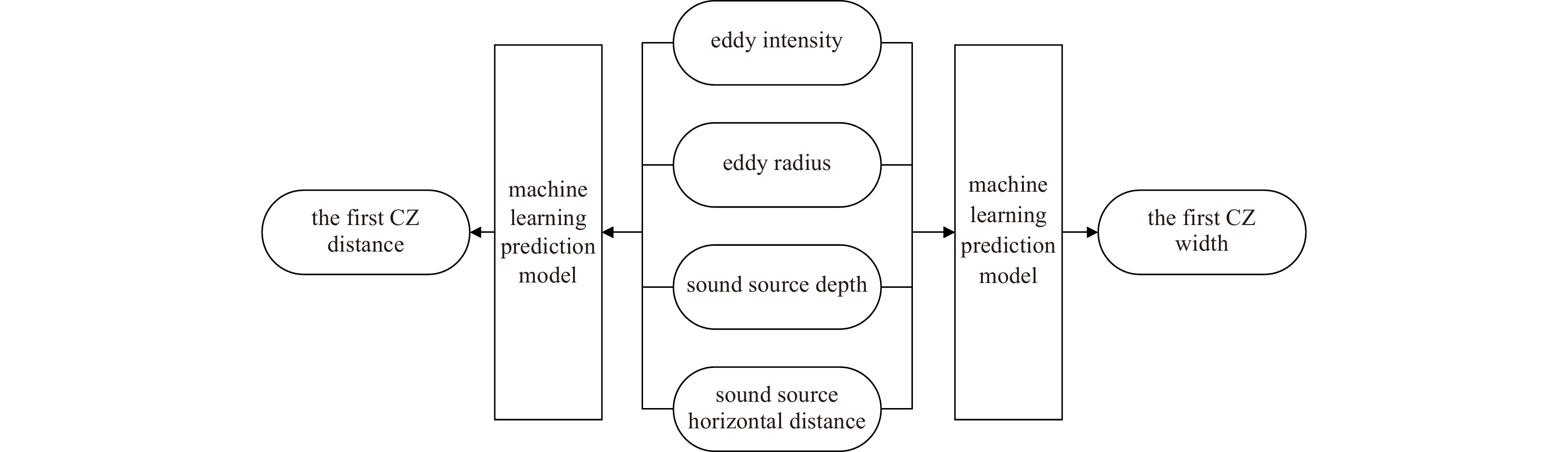

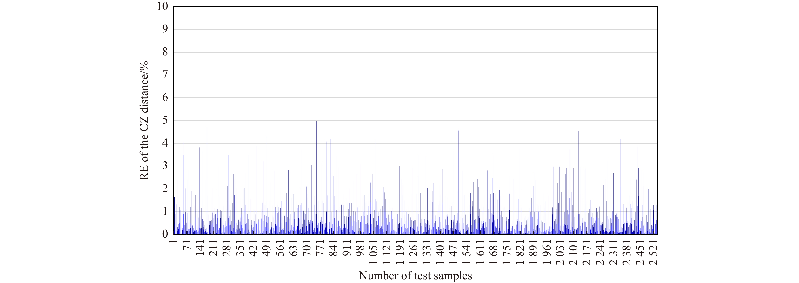


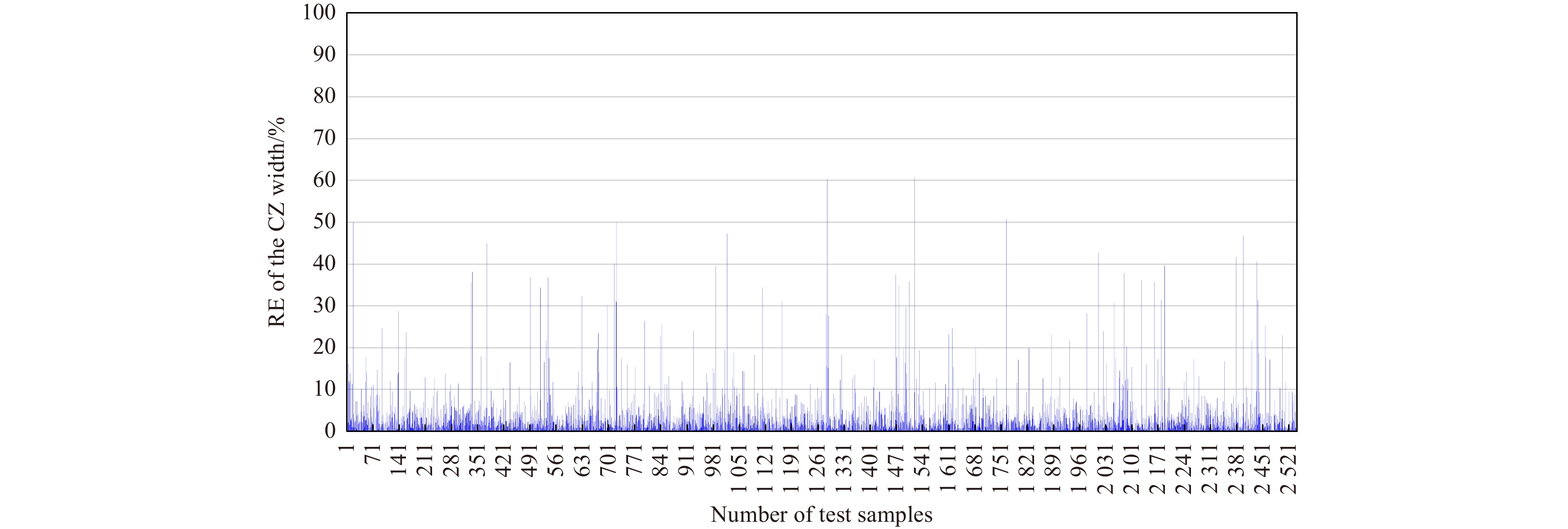

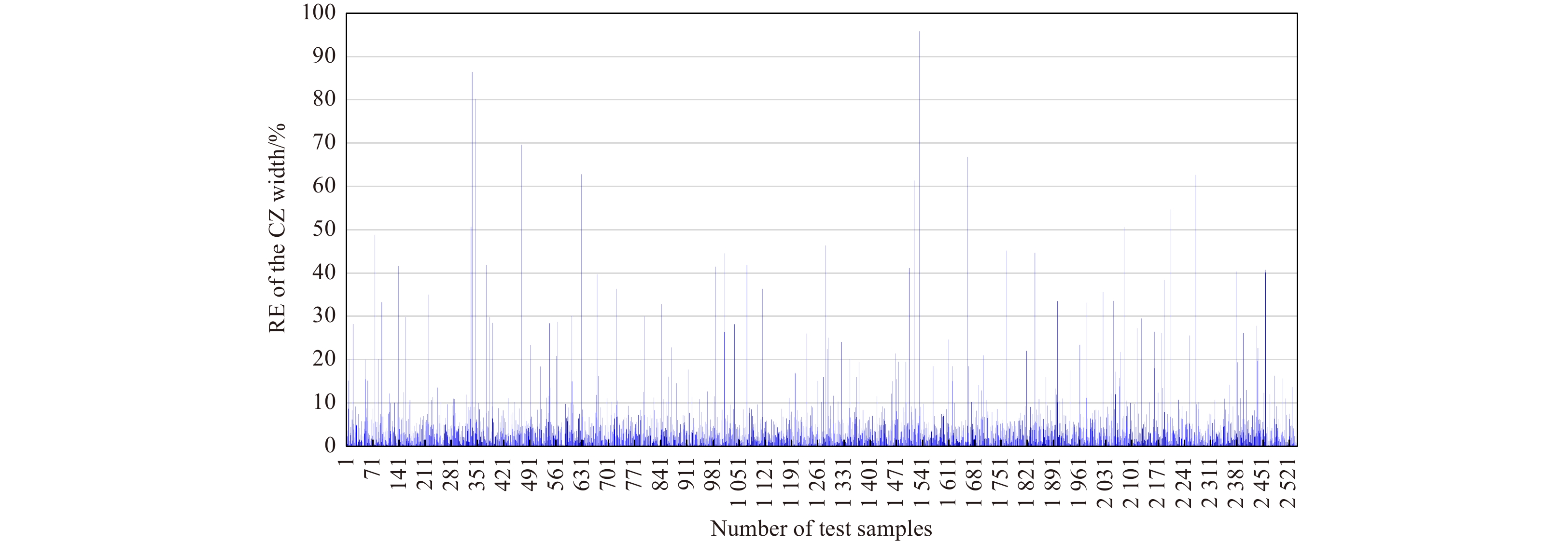
2024, 43(5): 121-132.
doi: 10.1007/s13131-024-2329-4
Abstract:
The Stokes production coefficient (E6) constitutes a critical parameter within the Mellor-Yamada type (MY-type) Langmuir turbulence (LT) parameterization schemes, significantly affecting the simulation of turbulent kinetic energy, turbulent length scale, and vertical diffusivity coefficient for turbulent kinetic energy in the upper ocean. However, the accurate determination of its value remains a pressing scientific challenge. This study adopted an innovative approach by leveraging deep learning technology to address this challenge of inferring the E6. Through the integration of the information of the turbulent length scale equation into a physical-informed neural network (PINN), we achieved an accurate and physically meaningful inference of E6. Multiple cases were examined to assess the feasibility of PINN in this task, revealing that under optimal settings, the average mean squared error of the E6 inference was only 0.01, attesting to the effectiveness of PINN. The optimal hyperparameter combination was identified using the Tanh activation function, along with a spatiotemporal sampling interval of 1 s and 0.1 m. This resulted in a substantial reduction in the average bias of the E6 inference, ranging from O(101) to O(102) times compared with other combinations. This study underscores the potential application of PINN in intricate marine environments, offering a novel and efficient method for optimizing MY-type LT parameterization schemes.
The Stokes production coefficient (E6) constitutes a critical parameter within the Mellor-Yamada type (MY-type) Langmuir turbulence (LT) parameterization schemes, significantly affecting the simulation of turbulent kinetic energy, turbulent length scale, and vertical diffusivity coefficient for turbulent kinetic energy in the upper ocean. However, the accurate determination of its value remains a pressing scientific challenge. This study adopted an innovative approach by leveraging deep learning technology to address this challenge of inferring the E6. Through the integration of the information of the turbulent length scale equation into a physical-informed neural network (PINN), we achieved an accurate and physically meaningful inference of E6. Multiple cases were examined to assess the feasibility of PINN in this task, revealing that under optimal settings, the average mean squared error of the E6 inference was only 0.01, attesting to the effectiveness of PINN. The optimal hyperparameter combination was identified using the Tanh activation function, along with a spatiotemporal sampling interval of 1 s and 0.1 m. This resulted in a substantial reduction in the average bias of the E6 inference, ranging from O(101) to O(102) times compared with other combinations. This study underscores the potential application of PINN in intricate marine environments, offering a novel and efficient method for optimizing MY-type LT parameterization schemes.
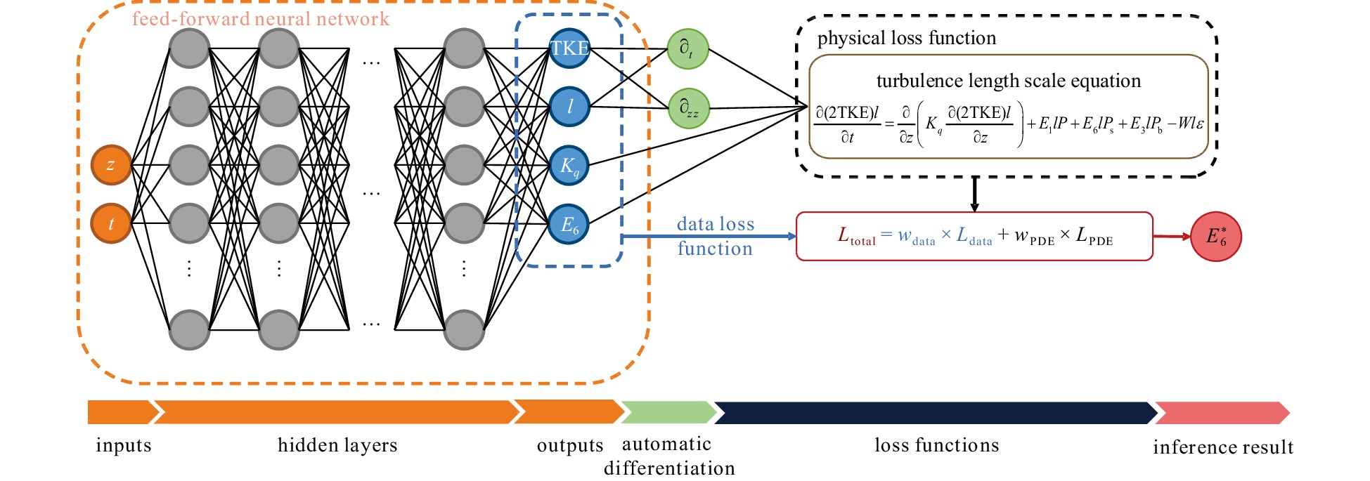


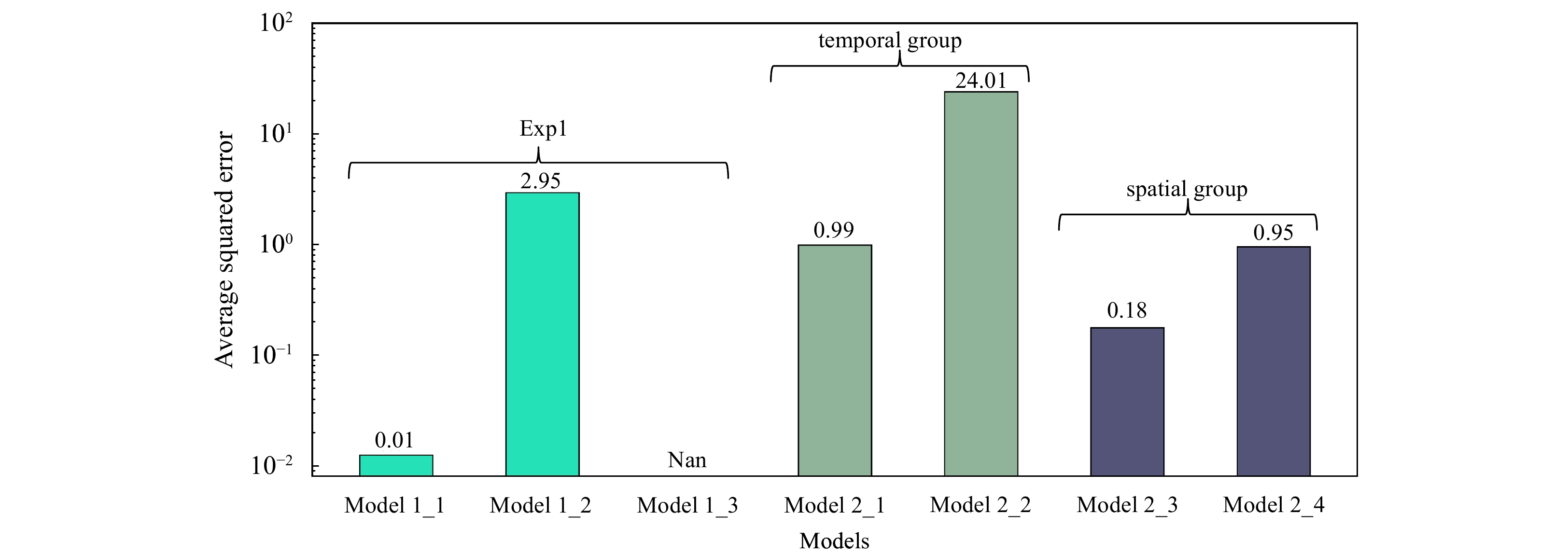


2024, 43(5): 133-144.
doi: 10.1007/s13131-024-2320-0
Abstract:
Synthetic aperture radar (SAR) and wave spectrometers, crucial in microwave remote sensing, play an essential role in monitoring sea surface wind and wave conditions. However, they face inherent limitations in observing sea surface phenomena. SAR systems, for instance, are hindered by an azimuth cut-off phenomenon in sea surface wind field observation. Wave spectrometers, while unaffected by the azimuth cutoff phenomenon, struggle with low azimuth resolution, impacting the capture of detailed wave and wind field data. This study utilizes SAR and surface wave investigation and monitoring (SWIM) data to initially extract key feature parameters, which are then prioritized using the extreme gradient boosting (XGBoost) algorithm. The research further addresses feature collinearity through a combined analysis of feature importance and correlation, leading to the development of an inversion model for wave and wind parameters based on XGBoost. A comparative analysis of this model with ERA5 reanalysis and buoy data for of significant wave height, mean wave period, wind direction, and wind speed reveals root mean square errors of 0.212 m, 0.525 s, 27.446°, and 1.092 m/s, compared to 0.314 m, 0.888 s, 27.698°, and 1.315 m/s from buoy data, respectively. These results demonstrate the model’s effective retrieval of wave and wind parameters. Finally, the model, incorporating altimeter and scatterometer data, is evaluated against SAR/SWIM single and dual payload inversion methods across different wind speeds. This comparison highlights the model’s superior inversion accuracy over other methods.
Synthetic aperture radar (SAR) and wave spectrometers, crucial in microwave remote sensing, play an essential role in monitoring sea surface wind and wave conditions. However, they face inherent limitations in observing sea surface phenomena. SAR systems, for instance, are hindered by an azimuth cut-off phenomenon in sea surface wind field observation. Wave spectrometers, while unaffected by the azimuth cutoff phenomenon, struggle with low azimuth resolution, impacting the capture of detailed wave and wind field data. This study utilizes SAR and surface wave investigation and monitoring (SWIM) data to initially extract key feature parameters, which are then prioritized using the extreme gradient boosting (XGBoost) algorithm. The research further addresses feature collinearity through a combined analysis of feature importance and correlation, leading to the development of an inversion model for wave and wind parameters based on XGBoost. A comparative analysis of this model with ERA5 reanalysis and buoy data for of significant wave height, mean wave period, wind direction, and wind speed reveals root mean square errors of 0.212 m, 0.525 s, 27.446°, and 1.092 m/s, compared to 0.314 m, 0.888 s, 27.698°, and 1.315 m/s from buoy data, respectively. These results demonstrate the model’s effective retrieval of wave and wind parameters. Finally, the model, incorporating altimeter and scatterometer data, is evaluated against SAR/SWIM single and dual payload inversion methods across different wind speeds. This comparison highlights the model’s superior inversion accuracy over other methods.


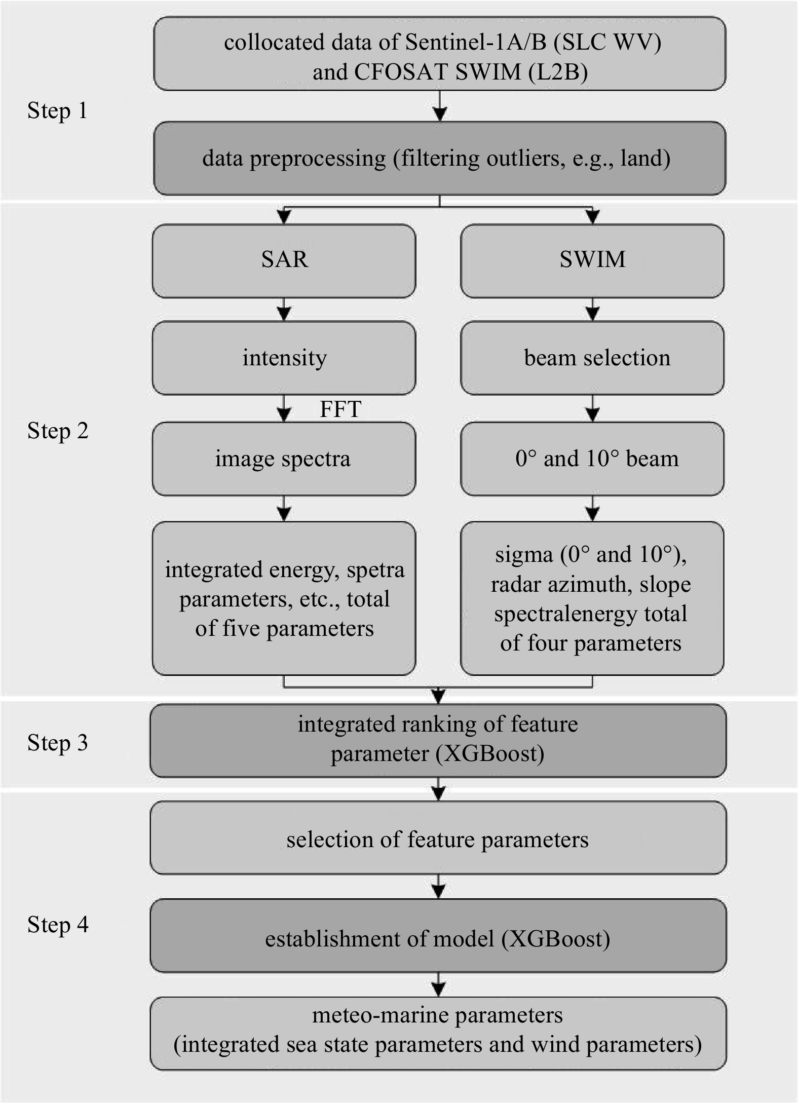

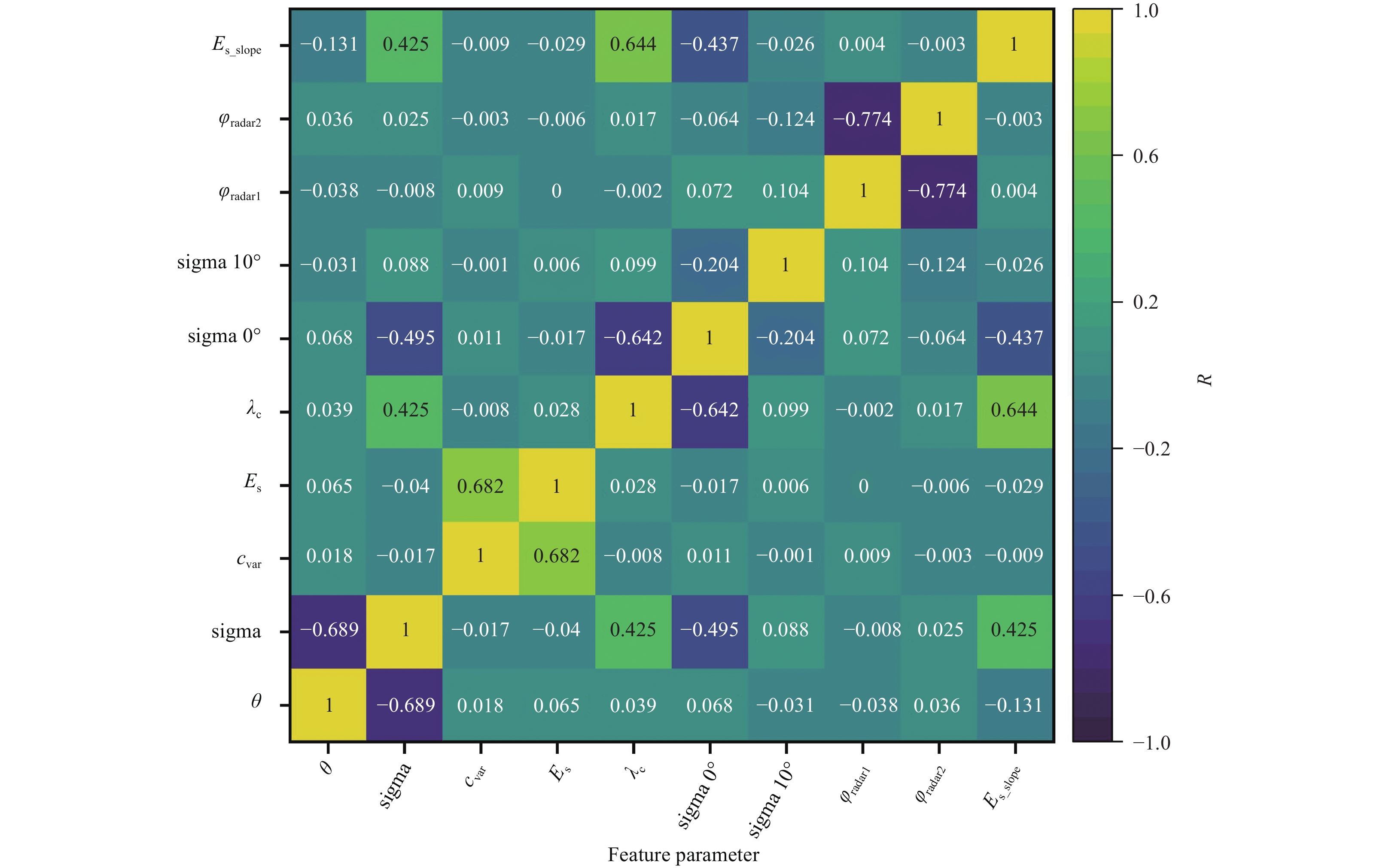
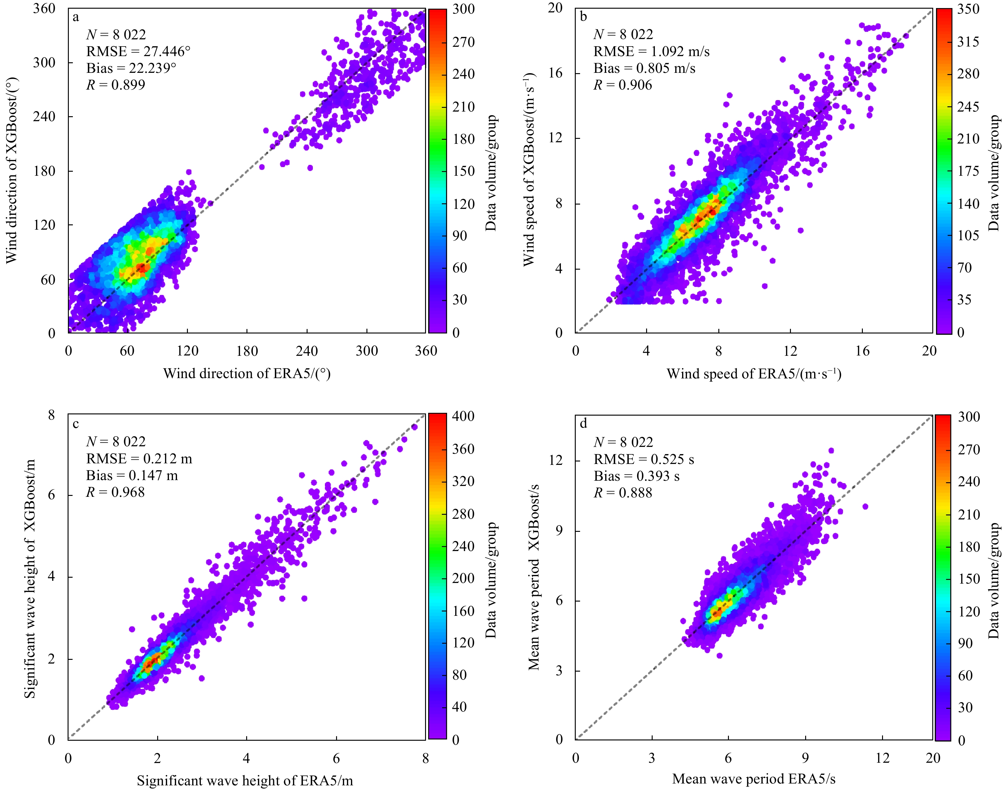
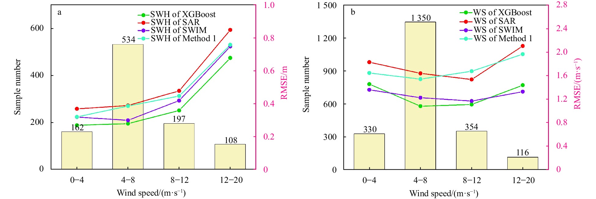
Latest Issues
Impact Factor: 0
ISSN 0253-505X (Print)
0253-505X (Online)
CN 11-2056/P
ISSN 0253-505X (Print)
0253-505X (Online)
CN 11-2056/P
ISSN 0253-505X
CN 11-2056/P
Impact Factor: 0
ISSN 0253-505X (Print)
0253-505X (Online)
CN 11-2056/P
ISSN 0253-505X (Print)
0253-505X (Online)
CN 11-2056/P
ISSN 0253-505X
CN 11-2056/P
Impact Factor: 0
ISSN 0253-505X (Print)
0253-505X (Online)
CN 11-2056/P
ISSN 0253-505X (Print)
0253-505X (Online)
CN 11-2056/P
ISSN 0253-505X
CN 11-2056/P
Impact Factor: 0
ISSN 0253-505X (Print)
0253-505X (Online)
CN 11-2056/P
ISSN 0253-505X (Print)
0253-505X (Online)
CN 11-2056/P
ISSN 0253-505X
CN 11-2056/P
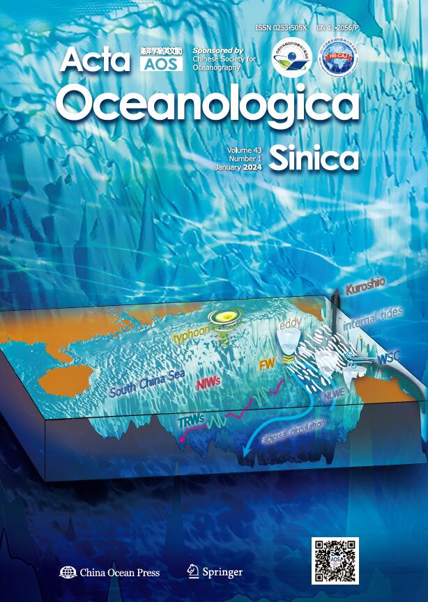
Impact Factor: 0
ISSN 0253-505X (Print)
0253-505X (Online)
CN 11-2056/P
ISSN 0253-505X (Print)
0253-505X (Online)
CN 11-2056/P
ISSN 0253-505X
CN 11-2056/P
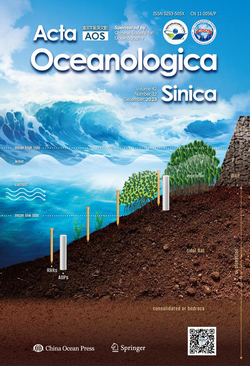
Impact Factor: 0
ISSN 0253-505X (Print)
0253-505X (Online)
CN 11-2056/P
ISSN 0253-505X (Print)
0253-505X (Online)
CN 11-2056/P
ISSN 0253-505X
CN 11-2056/P


