

Scale effect of coastal landscape pattern stability and driving forces: a case study of Guangdong Province, China
-
Abstract: The long-term dynamic evolution and underlying mechanisms of coastal landscape pattern stability, driven by strong anthropogenic interference and consequently climate change, are topics of major interest in national and international scientific research. Guangdong Province, located in southeastern China, has been undergoing rapid urbanization over several decades. In this study, we quantitatively determined the scale threshold characteristics of coastal landscape pattern stability in Guangdong Province, from the dual perspective of spatial heterogeneity and spatial autocorrelation. An analysis of the spatiotemporal evolution of the coastal landscape was conducted after the optical scale was determined. Then, we applied the geodetector statistical method to quantitatively explore the mechanisms underlying coastal landscape pattern stability. Based on the inflection point of landscape metrics and the maximum value of the Moran Ⅰ index, the optimal scale for analyzing coastal landscape pattern stability in Guangdong Province was 240 m × 240 m. Within the past several decades, coastal landscape pattern stability increased slightly and then decreased, with a turning point around 2005. The most significant variations in coastal landscape pattern stability were observed in the transition zone of rural-urban expansion. A q-statistics analysis showed that the explanatory power of paired factors was greater than that of a single driving factor; the paired factors with the greatest impact on coastal landscape pattern stability in Guangdong Province were the change in gross industrial output and change in average annual precipitation from 2010 to 2015, based on a q value of 0.604. These results will contribute to future efforts to achieve sustainable coastal development and provide a scientific basis and technical support for the rational planning and utilization of resources in large estuarine areas, including marine disaster prevention and seawall ecological restoration.
-

Figure 1. Location of the coastal zone in Guangdong Province, China. ZJ: Zhanjiang City; MM: Maoming City; YJ: Yanjiang City; JM: Jiangmen City; ZH: Zhuhai City; ZS: Zhongshan City; GZ: Guangzhou City; DG: Dongguan City; SZ: Shenzhen City; HZ: Huizhou City; SW: Shanwei City; JY: Jieyang City; ST: Shantou City; CZ: Chaozhou City. Drawing from Minstry of Natural Resources of China (http://bzdt.eh.mnr.gov.cn/). Approval number: GS(2020)no.4619.

Figure 2. Sensitivity analysis of four indices to classification accuracy. NDWI: normalized difference water index; NDVI: normalized difference vegetation index; EVI: enhanced vegetation index; MVI: mangrove vegetation index.

Figure 3. Seven landscape-level pattern metrics response curves to progressively increasing grain size. PD: patch density; MPS: mean patch size; TECI: total edge contrast index, MPI: mean proximity index, AI: aggregation index, CONTAG: contagion; SHDI: Shannon’s diversity index; p < 0.01.
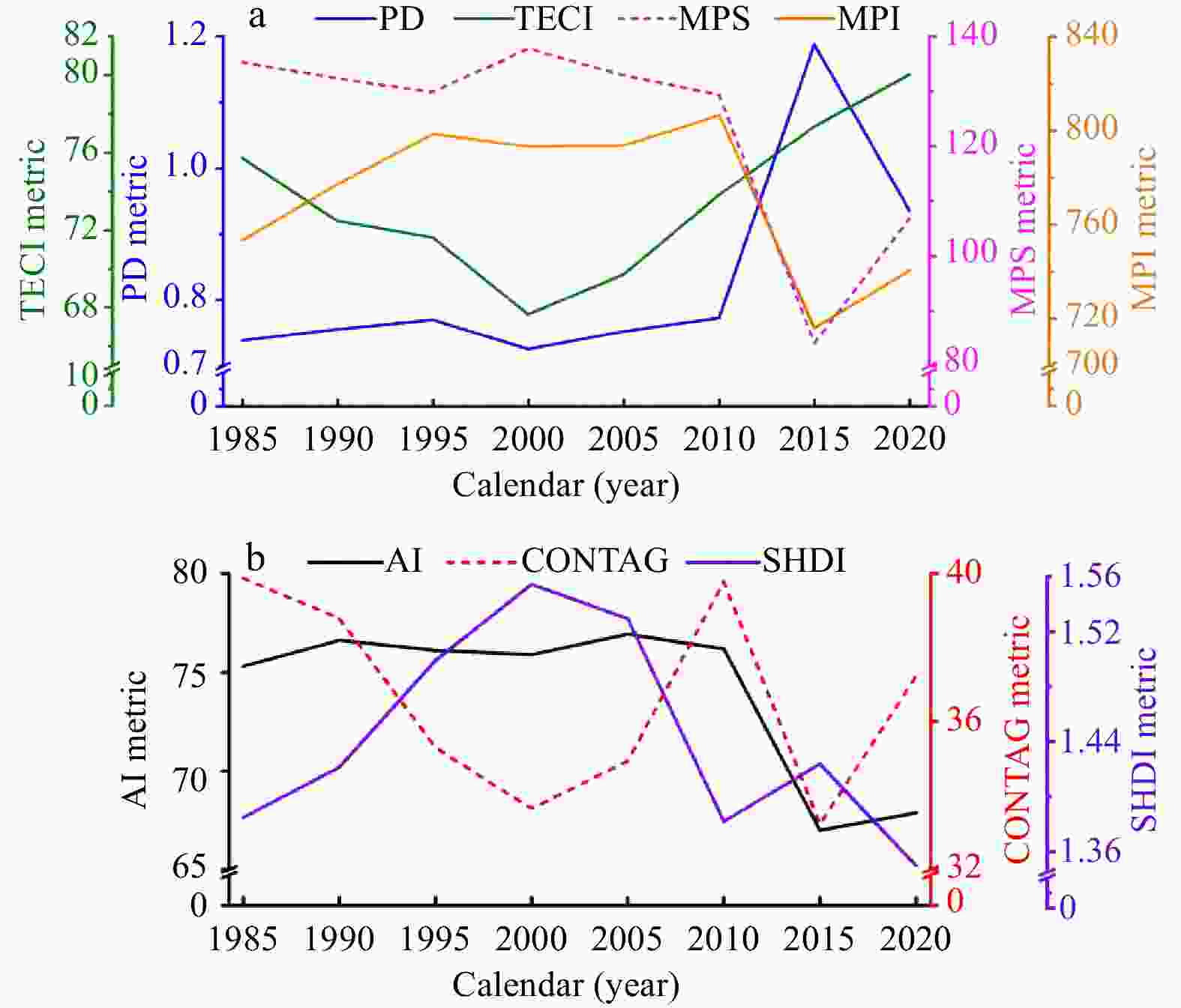
Figure 4. Spatiotemporal patterns of urbanization in the coastal zone of Guangdong Province as described by seven landscape-level pattern metrics at the optimal analysis scale. PD: patch density; TECI: total edge contrast index; MPS: mean patch size; MPI: mean proximity index; AI: aggregation index; CONTAG: contagion; SHDI: Shannon’s diversity index.

Figure 5. Spatiotemporal patterns of coastal landscape stability in Guangdong Province from 1985 to 2020. WCZ: western coastal zone of Guangdong Province; MCZ: middle coastal zone of Guangdong Province; ECZ: eastern coastal zone of Guangdong Province.

Figure 6. Changes in coastal landscape pattern stability in Guangdong Province from 1985 to 2020. WCZ: western coastal zone of Guangdong Province; MCZ: middle coastal zone of Guangdong Province; ECZ: eastern coastal zone of Guangdong Province. Landscape stability decreased: the annual mean stability metric belowed –0.05; landscape stability increased: the annual mean stability metric begonded 0.05; landscape relative stability: the annual mean stability metric ranged from –0.05 to 0.05.

Figure 7. q values of influential factors (X1−X8) from 1985 to 2020. X1: Change in population density; X2: change in the agricultural output value; X3: change in the gross industrial output value; X4: change in the road network density; X5: DEM, digital elevation model; X6: slope; X7: average annual temperature change; X8: average annual precipitation change. p < 0.01.

Figure 8. Interaction detection results of potential influencing factors (X1−X8). X1: change in population density; X2: change in the agricultural output value; X3: change in the gross industrial output value; X4: change in the road network density; X5: DEM, digital elevation model; X6: slope; X7: average annual temperature change; X8: average annual precipitation change.
Table 1. Remote sensing data used in this study
Year Data Sensor Number
of scenesMonth of acquisition Cloud cover Spatial resolution and
revisit timePath and row 1985 Landsat-5 TM/ETM+ thematic mapper/enhanced thematic mapper plus 16 from June to September in each typical year <5% 30 m × 30 m, 16 d paths: 119–124, rows: 43–46 1990 Landsat-5 TM/ETM+ thematic mapper/enhanced thematic mapper plus 16 from June to September in each typical year <5% 30 m × 30 m, 16 d paths: 119–124, rows: 43–46 1995 Landsat-5 TM/ETM+ thematic mapper/enhanced thematic mapper plus 15 from June to September in each typical year <5% 30 m × 30 m, 16 d paths: 119–124, rows: 43–46 2000 Landsat-5 TM/ETM+ thematic mapper/enhanced thematic mapper plus 16 from June to September in each typical year <5% 30 m × 30 m, 16 d paths: 119–124, rows: 43–46 2005 Landsat-5 TM/ETM+ thematic mapper/enhanced thematic mapper plus 16 from June to September in each typical year <5% 30 m × 30 m, 16 d paths: 119–124, rows: 43–46 2010 Landsat-5 TM/ETM+ thematic mapper/enhanced thematic mapper plus 16 from June to September in each typical year <5% 30 m × 30 m, 16 d paths: 119–124, rows: 43–46 2015 Landsat-8
OLIoperational land imager 15 from June to September in each typical year <5% 30 m × 30 m, 16 d paths: 119–124, rows: 43–46 2020 Landsat-8
OLIoperational land imager 15 from June to September in each typical year <5% 30 m × 30 m, 16 d paths: 119–124, rows: 43–46 Note: Total number of scenes is 125.  下载: 导出CSV
Table 2. User’s accuracy, total accuracy and Kappa coefficients for the landscape classification result
Calendar (year) User’s accuracy/% Total accuracy/% Kappa coefficient Impervious water surface Water Forest Farmland Mangrove forest Other 1985 83.33 85.67 85.00 82.67 81.33 80.33 83.06 0.826 1990 84.67 87.00 86.00 83.33 82.33 82.00 84.22 0.842 1995 86.00 88.33 87.00 85.00 84.00 82.33 85.41 0.851 2000 87.00 89.33 88.67 87.00 84.67 82.67 86.56 0.854 2005 88.33 90.67 90.00 87.00 86.67 84.67 87.89 0.865 2010 89.33 91.33 90.67 88.33 87.00 85.33 88.67 0.876 2015 91.00 92.33 91.33 89.00 87.67 86.00 89.56 0.888 2020 91.67 93.00 92.00 89.33 88.33 86.67 90.17 0.898
下载: 导出CSV
Table 3. Types of potential factors driving landscape pattern stability
Criteria Interaction type q(X1 ∩ X2) < Min(q(X1), q(X2)) nonlinear weakening Min(q(X1), q(X2)) < q(X1 ∩ X2) < Max(q( X1), q( X2)) single-factor nonlinear attenuation q(X1 ∩ X2) > Max(q(X1), q(X2)) two-factor interaction enhancement q(X1 ∩ X2) = q(X1) + q(X2) independence q(X1 ∩ X2) > q(X1) + q(X2) nonlinear enhancement
下载: 导出CSV
-
Baloloy A B, Blanco A C, Ana R R C S, et al. 2020. Development and application of a new mangrove vegetation index (MVI) for rapid and accurate mangrove mapping. ISPRS Journal of Photogrammetry and Remote Sensing, 166: 95–117, doi: 10.1016/j.isprsjprs.2020.06.001 Cantos J O, Hernández M H, Amorós A M R, et al. 2010. Increased risk of flooding on the coast of Alicante (Region of Valencia, Spain). Natural Hazards and Earth System Sciences, 10(11): 2229–2234, doi: 10.5194/nhess-10-2229-2010 Chen Kanglin, Chen Sikai, Gong Jianzhou. 2023a. Land cover change and driving forces detection of the coastal landscape in the Pearl River Estuary based on GEE cloud platform. South China Geographical Journal (in Chinese), (3): 10–24 Chen Yuangong, Chen Wenli, Gong Jianzhou, et al. 2023b. Uncommonly known change characteristics of land use pattern in Guangdong Province–Hong Kong–Macao, China: Space time pattern, terrain gradient effects and policy implication. Land Use Policy, 125: 106461, doi: 10.1016/j.landusepol.2022.106461 Chen Yanhui, Cui Linlin, Li Guosheng, et al. 2023c. A quantitative analysis of the impact of reclamation on the stability of coastal wetlands. Ocean & Coastal Management, 244: 106823, doi: 10.1016/j.ocecoaman.2023.106823 Chen Yufu, Dong Ming. 2003. Spatial heterogeneity in ecological systems. Acta Ecologica Sinica (in Chinese), 23(2): 346–352 Chen Kanglin, Dong Zining, Gong Jianzhou. 2024. Monitoring dynamic mangrove landscape patterns in China: Effects of natural and anthropogenic forcings during 1985–2020. Ecological Informatics, 81: 102582, doi: 10.1016/j.ecoinf.2024.102582 Chen Kanglin, Dong Haoyan, Jia Liangwen, et al. 2020. Depocentre transfer in the Lingdingyang estuary: Interferences from natural and anthropogenic forcings. Ocean & Coastal Management, 185: 105064, doi: 10.1016/j.ocecoaman.2019.105064 Chen Shenglan, Lin Wenzhi, Zeng Chen, et al. 2023d. Mapping the fishing intensity in the coastal waters off Guangdong province, China through AIS data. Water Biology and Security, 2(1): 100090, doi: 10.1016/j.watbs.2022.100090 Chen Jiazheng, Wang Li, Ma Lin, et al. 2023e. Quantifying the scale effect of the relationship between land surface temperature and landscape pattern. Remote Sensing, 15(8): 2131, doi: 10.3390/rs15082131 Cheng Yan, Li Yili, Chang Zhongbing, et al. 2022. Landscape ecological risk assessment based on land use change—A case study of coastal zone of Guangdong Province. Environmental Ecology (in Chinese), 4(11): 23–33 Chi Yuan, Zhang Zhiwei, Gao Jianhua, et al. 2019. Evaluating landscape ecological sensitivity of an estuarine island based on landscape pattern across temporal and spatial scales. Ecological Indicators, 101: 221–237, doi: 10.1016/j.ecolind.2019.01.012 Costanza R, D’Arge R, de Groot R, et al. 1997. The value of the world’s ecosystem services and natural capital. Nature, 387(6630): 253–260, doi: 10.1038/387253a0 Cui Shanshan, Liu Qing, Wang Jing. 2016. Scale effect of landscape pattern index and its response to land use change in the coastal development zone: A case study of Dafeng City in Jiangsu Province. Geography and Geo-Information Science (in Chinese), 32(6): 87–93 Cushman S A, McGarigal K. 2002. Hierarchical, multi-scale decomposition of species-environment relationships. Landscape Ecology, 17(7): 637–646, doi: 10.1023/A:1021571603605 Davis Z, Nesbitt L, Guhn M, et al. 2023. Assessing changes in urban vegetation using Normalised Difference Vegetation Index (NDVI) for epidemiological studies. Urban Forestry & Urban Greening, 88: 128080, doi: 10.1016/j.ufug.2023.128080 Ghosh S M, Behera M D, Jagadish B, et al. 2021. A novel approach for estimation of aboveground biomass of a carbon-rich mangrove site in India. Journal of Environmental Management, 292: 112816, doi: 10.1016/j.jenvman.2021.112816 Gong Jianzhou, Xia Beicheng, Li Nan. 2006. Characteristics of scale and hierachical structure of landscape system under different heterogeneities of land cover patterns in Guangzhou City. Acta Geographica Sinica (in Chinese), 61(8): 873–881 Gorelick N, Hancher M, Dixon M, et al. 2017. Google Earth Engine: planetary-scale geospatial analysis for everyone. Remote Sensing of Environment, 202: 18–27, doi: 10.1016/j.rse.2017.06.031 Grimm N B, Faeth S H, Golubiewski N E, et al. 2008. Global change and the ecology of cities. Science, 319(5864): 756–760, doi: 10.1126/science.1150195 Guangdong Provincial Bureau of Statistics, Survey Office of the National Bureau of Statistics in Guangdong. 2022. Guangdong Statistical Yearbook 2022 (in Chinese). Beijing, China: China Statistics Press Guo Tengjiao, Li Guosheng, He Lei. 2022. Risk assessment of typhoon storm surge based on a simulated annealing algorithm and the least squares method: a case study in Guangdong Province, China. Natural Hazards Research, 2(3): 249–258, doi: 10.1016/j.nhres.2022.08.005 Halder S, Samanta K, Das S, et al. 2021. Monitoring the inter-decade spatial-temporal dynamics of the Sundarban mangrove forest of India from 1990 to 2019. Regional Studies in Marine Science, 44: 101718, doi: 10.1016/j.rsma.2021.101718 Hanke W, Böhner J, Dreber N, et al. 2014. The impact of livestock grazing on plant diversity: an analysis across dryland ecosystems and scales in southern Africa. Ecological Applications, 24(5): 1188–1203, doi: 10.1890/13-0377.1 Hauser L T, Vu G N, Nguyen B A, et al. 2017. Uncovering the spatio-temporal dynamics of land cover change and fragmentation of mangroves in the Ca Mau peninsula, Vietnam using multi-temporal SPOT satellite imagery (2004–2013). Applied Geography, 86: 197–207, doi: 10.1016/j.apgeog.2017.06.019 Hu Changyue, Wu Wu, Zhou Xuexia, et al. 2023. Spatiotemporal changes in landscape patterns in karst mountainous regions based on the optimal landscape scale: A case study of Guiyang City in Guizhou Province, China. Ecological Indicators, 150: 110211, doi: 10.1016/j.ecolind.2023.110211 Jiang Mengzhen, Chen Haiying, Chen Qinghui, et al. 2015. Wetland ecosystem integrity and its variation in an estuary using the EBLE index. Ecological Indicators, 48: 252–262, doi: 10.1016/j.ecolind.2014.08.008 Jiang Penghui, Chen Dengshuai, Li Manchun. 2021. Farmland landscape fragmentation evolution and its driving mechanism from rural to urban: A case study of Changzhou City. Journal of Rural Studies, 82: 1–18, doi: 10.1016/j.jrurstud.2021.01.004 Karaman M. 2021. Comparison of thresholding methods for shoreline extraction from Sentinel-2 and Landsat-8 imagery: Extreme Lake Salda, track of Mars on Earth. Journal of Environmental Management, 298: 113481, doi: 10.1016/j.jenvman.2021.113481 Kennedy R E, Yang Zhiqiang, Gorelick N, et al. 2018. Implementation of the LandTrendr algorithm on Google earth engine. Remote Sensing, 10(5): 691, doi: 10.3390/rs10050691 Kirwan M L, Langley J A, Guntenspergen G R, et al. 2013. The impact of sea-level rise on organic matter decay rates in Chesapeake Bay brackish tidal marshes. Biogeosciences, 10(3): 1869–1876, doi: 10.5194/bg-10-1869-2013 Li Jing, Hong Hongjia, Chen Zhiliang, et al. 2010. Analysis of land uses and landscape pattern changes in coastal area along Zhujiang River Estuary. Journal of Anhui Agricultural Sciences (in Chinese), 38(22): 11791–11794,11797 Li Lijuan, Li Guosheng, Du Jiaqiang, et al. 2022. Effects of tidal flat reclamation on the stability of coastal wetland ecosystem services: A case study in Jiangsu Coast, China. Ecological Indicators, 145: 109697, doi: 10.1016/j.ecolind.2022.109697 Lin Lijie, Chan Tingon, Ge Erjia, et al. 2020. Effects of urban land expansion on decreasing atmospheric moisture in Guangdong, South China. Urban Climate, 32: 100626, doi: 10.1016/j.uclim.2020.100626 Liu Zhikun, Chen Daliang, Chen Yiqing, et al. 2018. Study of land use landscape stability in Haikou. Forestry and Environmental Science (in Chinese), 34(5): 34–41 Liu Jiping, Ma Changdi. 2017. The spatial variation in the patch stability of marshes in Xianghai between 1985 and 2015. Acta Ecologica Sinica (in Chinese), 37(4): 1261–1269 Luo Geping, Zhou Chenghu, Chen Xi. 2004. Preliminary analysis on the Oasis stability at the landscape level in the Arid Regions. Arid Land Geography (in Chinese), 27(4): 471–476 Lv Yihe, Chen Liding, Fu Bojie. 2007. Analysis of the integrating approach on landscape pattern and ecological processes. Progress in Geography (in Chinese), 26(3): 1–10 Oehri J, Schmid B, Schaepman-Strub G, et al. 2017. Biodiversity promotes primary productivity and growing season lengthening at the landscape scale. Proceedings of the National Academy of Sciences of the United States of America, 114(38): 10160–10165, doi: 10.1073/pnas.1703928114 People’s Government of Guangdong Province. 2001. Outline of the tenth five-year plan for national economic and social development of Guangdong province. http://www.gd.gov.cn/zwgk/gongbao/2001/11/content/post_3360357.html[2001-03-26/2023-11-03] (in Chinese) People’s Government of Guangdong Province. 2011. Outline of the 12th five-year plan for national economic and social development of Guangdong province. http://drc.gd.gov.cn/gkmlpt/content/1/1057/mpost_1057601.html#876[2011-06-05/2023-11-03] (in Chinese) People’s Government of Guangdong Province. 2017. Overall plan for comprehensive protection and utilization of coastal zones of Guangdong province. https://www.gd.gov.cn/zwgk/gongbao/2017/35/content/post_3365693.html[2017-10-27/2023-11-03] (in Chinese) Phillips J D. 2018. Environmental gradients and complexity in coastal landscape response to sea level rise. CATENA, 169: 107–118, doi: 10.1016/j.catena.2018.05.036 Qiu Cailin, Qiu Ning, Zhang Tianjie. 2022. Temporal and spatial evolution of regional cultural landscape under the influence of construction land expansion: A case study of Hanjiang Delta in Guangdong, China. Chinese Journal of Applied Ecology (in Chinese), 33(11): 3065–3074 Rao Yingxue, Dai Jingyi, Dai Deyi, et al. 2021. Effect of urban growth pattern on land surface temperature in China: A multi-scale landscape analysis of 338 cities. Land Use Policy, 103: 105314, doi: 10.1016/j.landusepol.2021.105314 Rico-Amoros A M, Olcina-Cantos J, Sauri D. 2009. Tourist land use patterns and water demand: Evidence from the Western Mediterranean. Land Use Policy, 26(2): 493–501, doi: 10.1016/j.landusepol.2008.07.002 Sandilyan S, Kathiresan K. 2015. Density of waterbirds in relation to habitats of pichavaram mangroves, southern India. Journal of Coastal Conservation, 19(2): 131–139, doi: 10.1007/s11852-015-0376-x Serra P, Vera A, Tulla A F, et al. 2014. Beyond urban-rural dichotomy: Exploring socioeconomic and land-use processes of change in Spain (1991–2011). Applied Geography, 55: 71–81, doi: 10.1016/j.apgeog.2014.09.005 Song Yongze, Wang Jinfeng, Ge Yong, et al. 2020. An optimal parameters-based geographical detector model enhances geographic characteristics of explanatory variables for spatial heterogeneity analysis: Cases with different types of spatial data. GIScience & Remote Sensing, 57(5): 593–610, doi: 10.1080/15481603.2020.1760434 Sun Wanlong, Sun Zhigao, Tian Liping, et al. 2017. Variation and prediction of different marsh landscapes in intertidal zone of the Yellow River Delta. Acta Ecologica Sinica (in Chinese), 37(1): 215–225 Syvitski J P M, Kettner A J, Overeem I, et al. 2009. Sinking deltas due to human activities. Nature Geoscience, 2(10): 681–686, doi: 10.1038/NGEO629 Tang Shuo, Zhang Yun, Wei Donglan, et al. 2019. Research on temporal and spatial evolution of coastline stability in Liaoning province. Resource Development & Market (in Chinese), 35(12): 1472–1475 Tessler Z D, Vörösmarty C J, Grossberg M, et al. 2015. Profiling risk and sustainability in coastal deltas of the world. Science, 349(6248): 638–643, doi: 10.1126/science.aab3574 Tian Lixin, Han Mei, Wang Min, et al. 2021. Spatiotemporal evolution and stability of land use type in the coastal zone of the south coast in the Laizhou Bay. Research of Soil and Water Conservation (in Chinese), 28(4): 259–265,274 Trégarot E, Caillaud A, Cornet C C, et al. 2021. Mangrove ecological services at the forefront of coastal change in the French overseas territories. Science of the Total Environment, 763: 143004, doi: 10.1016/j.scitotenv.2020.143004 Turner M G, Gardner R H, O'Neill R V. 2001. Landscape ecology in Theory and Practice: Pattern and Process. New York, NY, USA: Springer-Verlag Turner M G, O'Neill R V, Gardner R H, et al. 1989. Effects of changing spatial scale on the analysis of landscape pattern. Landscape Ecology, 3(3): 153–162, doi: 10.1007/BF00131534 Wang Junqiang, Guo Qingxia, Zhao Fucai, et al. 2014. Situation analysis of landscape fragmentation in Cha-kou small watershed during land use (in Chinese). Journal of Shanxi Agricultural University (Natural Science Edition), 34(2): 152–156 Wang Qiang, Kang Qian, Zhao Bo, et al. 2022a. Effect of land-use and land-cover change on mangrove soil carbon fraction and metal pollution risk in Zhangjiang Estuary, China. Science of the Total Environment, 807: 150973, doi: 10.1016/j.scitotenv.2021.150973 Wang Jinfeng, Li Xinhu, Christakos G, et al. 2010. Geographical detectors-based health risk assessment and its application in the neural tube defects study of the Heshun region, China. International Journal of Geographical Information Science, 24(1): 107–127, doi: 10.1080/13658810802443457 Wang Jianying, Sun Qi, Zou Lilin. 2023. Spatial-temporal evolution and driving mechanism of rural production-living-ecological space in Pingtan islands, China. Habitat International, 137: 102833, doi: 10.1016/j.habitatint.2023.102833 Wang Renfeng, Wang Mengmeng, Zhang Zhengjia, et al. 2022b. Geographical detection of urban thermal environment based on the local climate zones: A case study in Wuhan, China. Remote Sensing, 14(5): 1067, doi: 10.3390/rs14051067 Wang Yue, Wen Haijia, Sun Deliang, et al. 2021. Quantitative assessment of landslide risk based on susceptibility mapping using random forest and GeoDetector. Remote Sensing, 13(13): 2625, doi: 10.3390/rs13132625 Wang Jinfeng, Xu Chengdong. 2017. Geodetector: Principle and prospective. Acta Geographica Sinica (in Chinese), 72(1): 116–134 Wetlands International. 2021. Wetlands. https://www.wetlands.org/wetlands/ Wickham J D, Wu J G, Bradford D F. 1997. A conceptual framework for selecting and analyzing stressor data to study species richness at large spatial scales. Environmental Management, 21(2): 247–257, doi: 10.1007/s002679900024 Williams B A, Watson J E M, Beyer H L, et al. 2022. Global rarity of intact coastal regions. Conservation Biology, 36(4): e13874, doi: 10.1111/cobi.13874 Wu Jianguo. 2007. Landscape Ecology: Pattern, Process, Scale and Hierarchy. 2nd ed. Beijing, China: Higher Education Press, 147–157 Wu Jianguo. 2004. Effects of changing scale on landscape pattern analysis: Scaling relations. Landscape Ecology, 19(2): 125–138, doi: 10.1023/B:LAND.0000021711.40074.AE Wu Jianguo, Jenerette G D, Buyantuyev A, et al. 2011. Quantifying spatiotemporal patterns of urbanization: The case of the two fastest growing metropolitan regions in the United States. Ecological Complexity, 8(1): 1–8, doi: 10.1016/j.ecocom.2010.03.002 Wu Ziyin, Milliman J D, Zhao Dineng, et al. 2018. Geomorphologic changes in the lower Pearl River Delta, 1850–2015, largely due to human activity. Geomorphology, 314: 42–54, doi: 10.1016/j.geomorph.2018.05.001 Wu Jianguo, Shen Weijun, Sun Weizhong, et al. 2002. Empirical patterns of the effects of changing scale on landscape metrics. Landscape Ecology, 17(8): 761–782, doi: 10.1023/A:1022995922992 Wu Songze, Wang Dongyan, Yan Zhuoran, et al. 2023. Spatiotemporal dynamics of urban green space in Changchun: Changes, transformations, landscape patterns, and drivers. Ecological Indicators, 147: 109958, doi: 10.1016/j.ecolind.2023.109958 Wu Haiman, Zhang Chunming. 2021. Analysis on the area evolution of coastal wetland in the Pearl River Delta. Jilin Water Resources (in Chinese), (12): 23–27 Xie Gaodi, Zhen Lin, Yang Li, et al. 2005. Landscape stability and its pattern transition in Jinghe watershed. Chinese Journal of Applied Ecology (in Chinese), 16(9): 1693–1698 Xu Sen, Li Siliang, Zhong Jun, et al. 2020. Spatial scale effects of the variable relationships between landscape pattern and water quality: example from an agricultural karst river basin, Southwestern China. Agriculture, Ecosystems & Environment, 300: 106999, doi: 10.1016/j.agee.2020.106999 Xu Qiuyang, Wang Weiwei, Mo Li. 2018. Evaluation of landscape stability in Beijing−Tianjin−Hebei region. Acta Ecologica Sinica (in Chinese), 38(12): 4226–4233, doi: 10.5846/stxb201801110087 Xu Qiyu, Wang Peng, Shu Wang, et al. 2021. Influence of landscape structures on river water quality at multiple spatial scales: A case study of the Yuan river watershed, China. Ecological Indicators, 121: 107226, doi: 10.1016/j.ecolind.2020.107226 Yeh C T, Huang Shuli. 2009. Investigating spatiotemporal patterns of landscape diversity in response to urbanization. Landscape and Urban Planning, 93(3/4): 151–162, doi: 10.1016/j.landurbplan.2009.07.002 You Chang, Zhou Yongbin, Yu Lifen. 2006. An introduction of quantitative methods in landscape pattern fragmentation. Chinese Agricultural Science Bulletin (in Chinese), 22(5): 146–151 Yuan Wei, Chang Yenchiang. 2021. Land and sea coordination: Revisiting integrated coastal management in the context of community interests. Sustainability, 13(15): 8183, doi: 10.3390/su13158183 Zhang Yingshi, Feng Yanfen, Guo Guanhua, et al. 2022. The spatio-temporal characteristics of construction land expansion in China’s typical urban agglomerations in recent 30 years: A case study of the Beijing-Tianjin-Hebei urban agglomeration and the Guangdong−Hong Kong−Macao greater bay area. Journal of South China Normal University (Natural Science Edition) (in Chinese), 54(1): 79–90 Zhang Hanwen, Lang Yanqing. 2022. Quantifying and analyzing the responses of habitat quality to land use change in Guangdong Province, China over the past 40 years. Land, 11(6): 817, doi: 10.3390/land11060817 Zhao Yuling. 2017. Remote sensing survey and proposal for protection of the shoreline and the mangrove wetland in Guangdong Province. Remote sensing for Land & Resources (in Chinese), 29(S1): 114–120 Zhao Feng, Liu Hua, Ju Hongbo, et al. 2012. Landscape stability and its pattern transition of typical wetlands in three river sources, southwestern China. Journal of Beijing Forestry University (in Chinese), 34(5): 69–74 Zheng Xi. 2023. Coastal landscapes. Landscape Architecture (in Chinese), 30(5): 1 Zheng Yuanmao, Tang Lina, Wang Haowei. 2021. An improved approach for monitoring urban built-up areas by combining NPP-VIIRS nighttime light, NDVI, NDWI, and NDBI. Journal of Cleaner Production, 328: 129488, doi: 10.1016/j.jclepro.2021.129488 Zhou Haohao, Du Jia, Nan Ying, et al. 2019. Landscape patterns of coastal wetlands in Pearl River Delta and their changes for 5 periods since 1980. Wetland Science (in Chinese), 17(5): 559–566 Zhou Long, Kong Xianglong, Shen Guoqiang, et al. 2023. Spatial-temporal impacts of landscape metrics and uses of land reclamation on coastal water conditions: The case of Macao. Ecological Indicators, 154: 110518, doi: 10.1016/j.ecolind.2023.110518 Zhu Mengjue, Zhuang Dachang, Yang Yuanhua. 2018. The regional type of population migration and management strategy in Guangdong Province since 1990. Economic Geography (in Chinese), 38(2): 43–50, 65 -


 点击查看大图

计量
- 文章访问数: 141
- HTML全文浏览量: 61
- PDF下载量: 11
- 被引次数: 0

