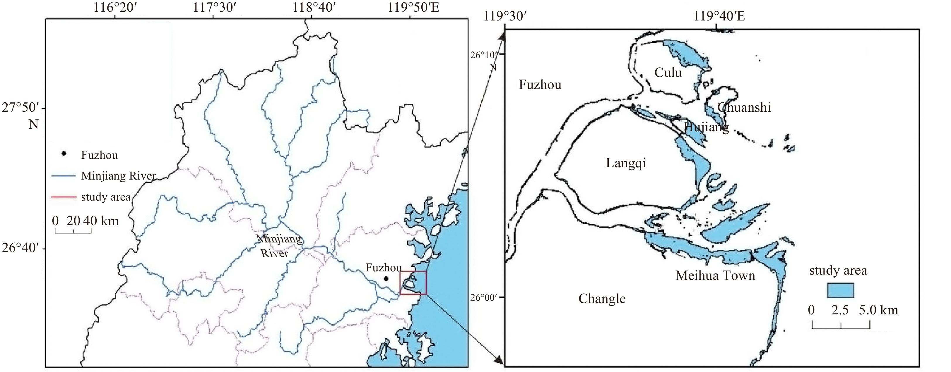
2023 Vol. 42, No. 7

Cover
Cover
2023, 42(7)
Abstract:
Contents
2023, 42(7)
Abstract:
Beach Protection and Restoration around the South China Sea
Using video imagery to reconstruct the 3D intertidal terrain along a beach with multiple cusps
Feng Cai, Hang Yin, Hongshuai Qi, Jixiang Zheng, Yuwu Jiang, Zhubin Cao, Yanyu He
2023, 42(7): 1-9. doi: 10.1007/s13131-023-2174-x
Abstract:
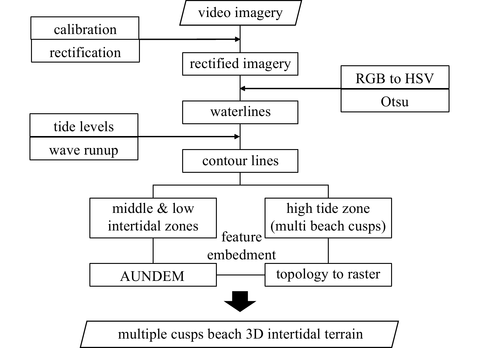
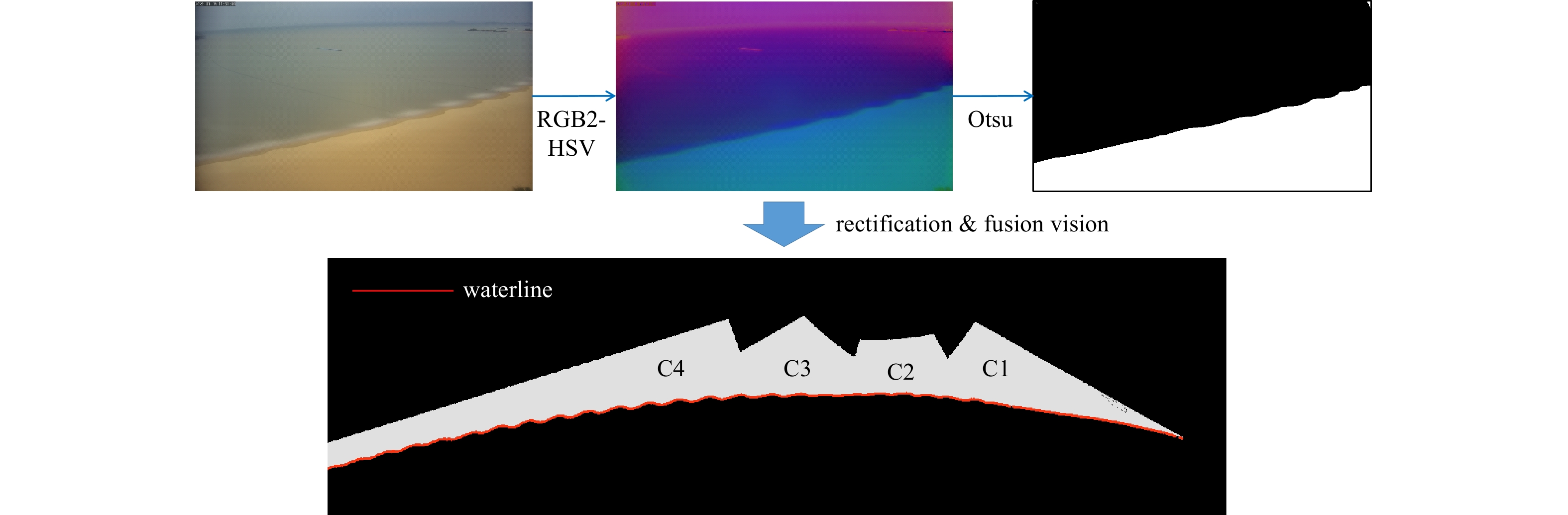
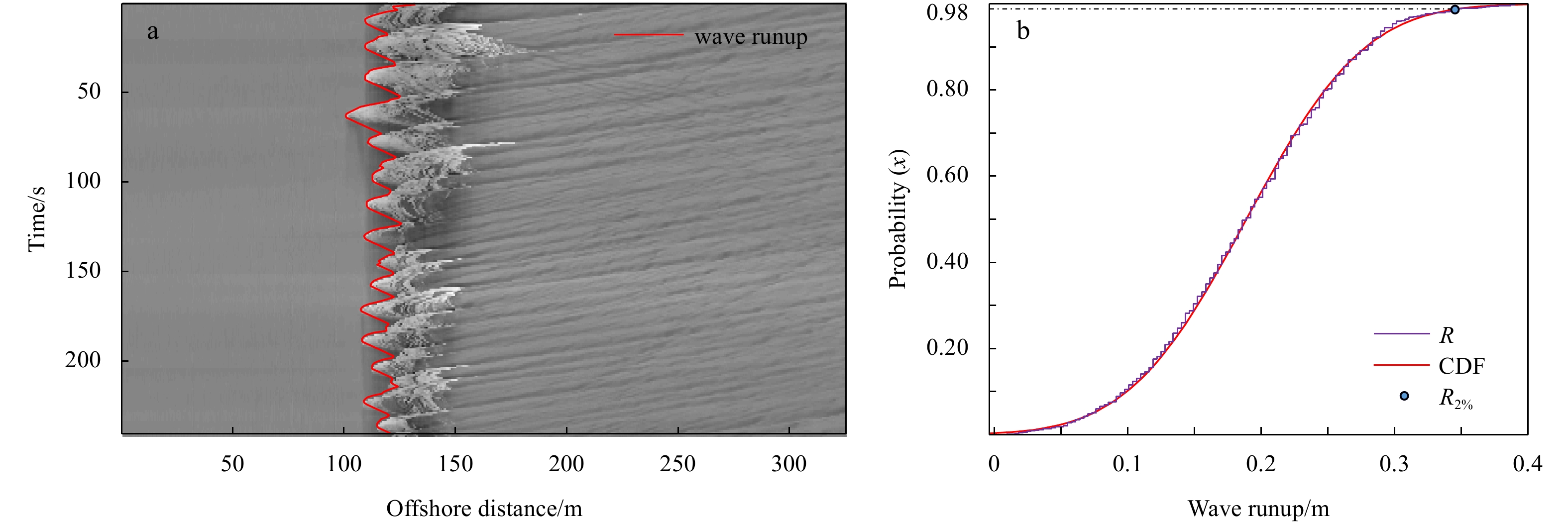
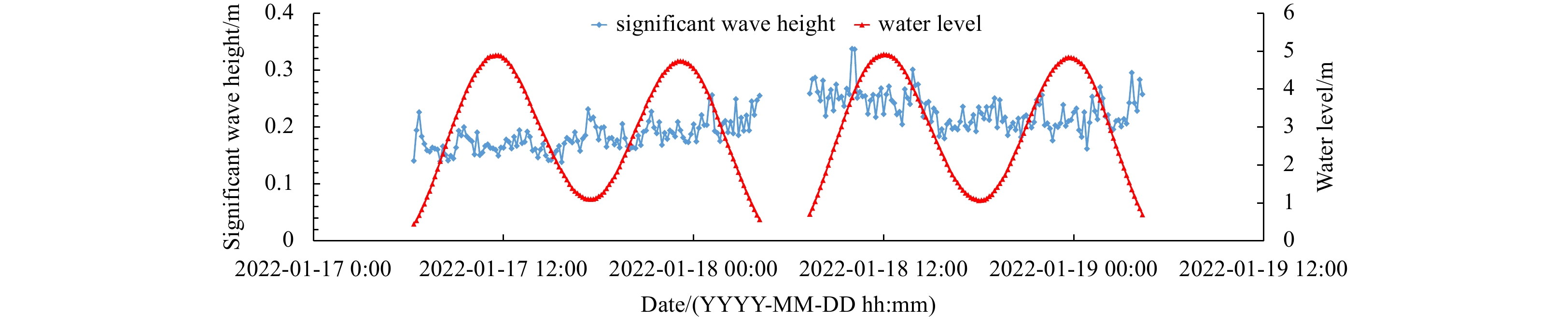
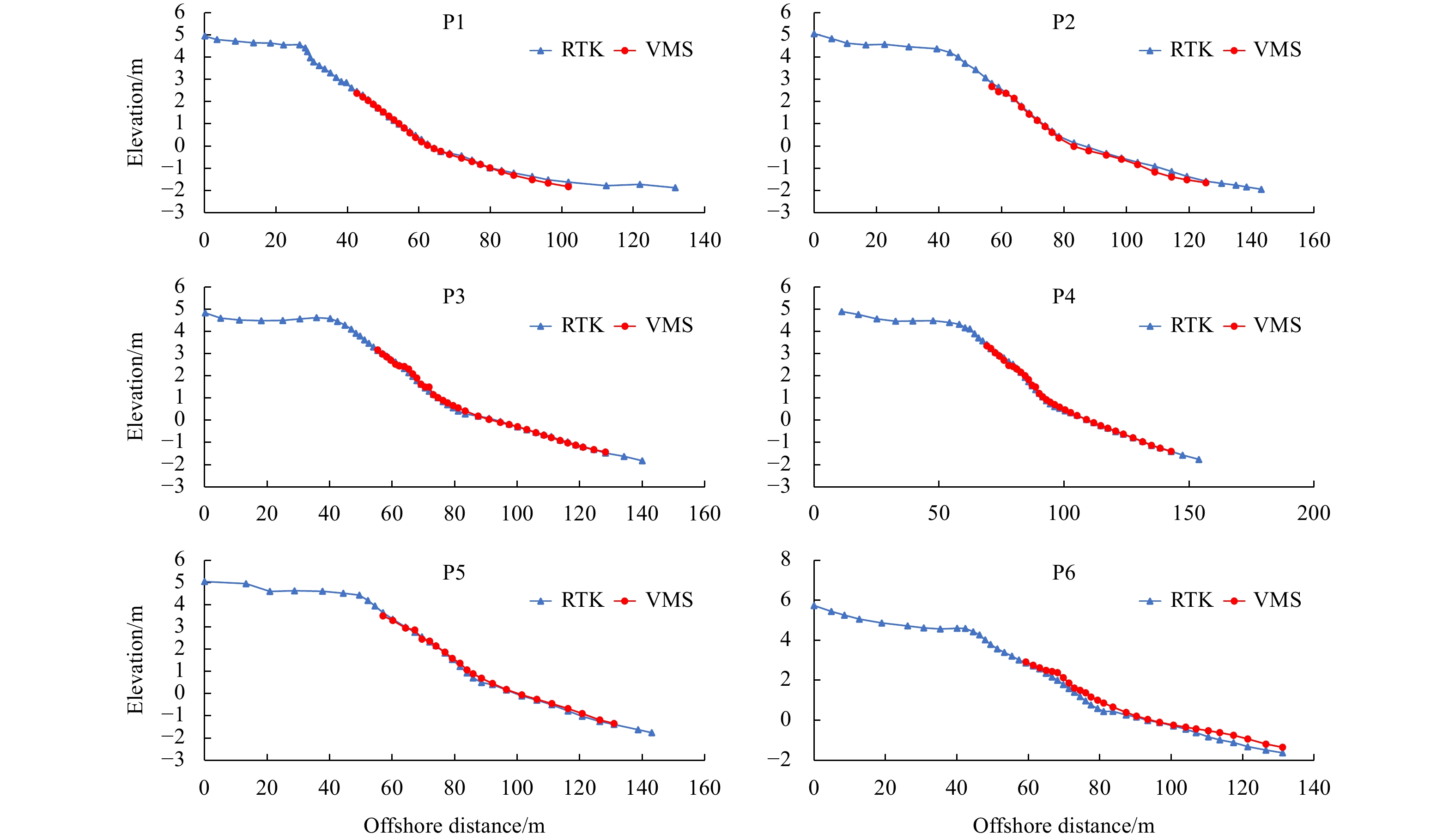
A high-frequency, high-resolution shore-based video monitoring system (VMS) was installed on a macrotidal (tidal amplitude >4 m) beach with multiple cusps along the Quanzhou coast, China. Herein, we propose a video imagery-based method that is coupled with waterline and water level observations to reconstruct the terrain of the intertidal zone over one tidal cycle. Furthermore, the beach cusp system (BCS) was precisely processed and embedded into the digital elevation model (DEM) to more effectively express the microrelief and detailed characteristics of the intertidal zone. During a field experiment conducted in January 2022, the reconstructed DEM was deemed satisfactory. The DEM was verified by RTK-GPS and had an average vertical root mean square error along corresponding RTK-GPS-derived intertidal profiles and corresponding BCS points of 0.134 m and 0.065 m, respectively. The results suggest that VMSs are an effective tool for investigating coastal geomorphic processes.
Sediment source-to-sink process variations of sandy-muddy transitional beaches and their morphological indications
Shaohua Zhao, Feng Cai, Hongshuai Qi, Jianhui Liu, Chao Cao, Gen Liu, Gang Lei
2023, 42(7): 10-24. doi: 10.1007/s13131-022-2077-2
Abstract:
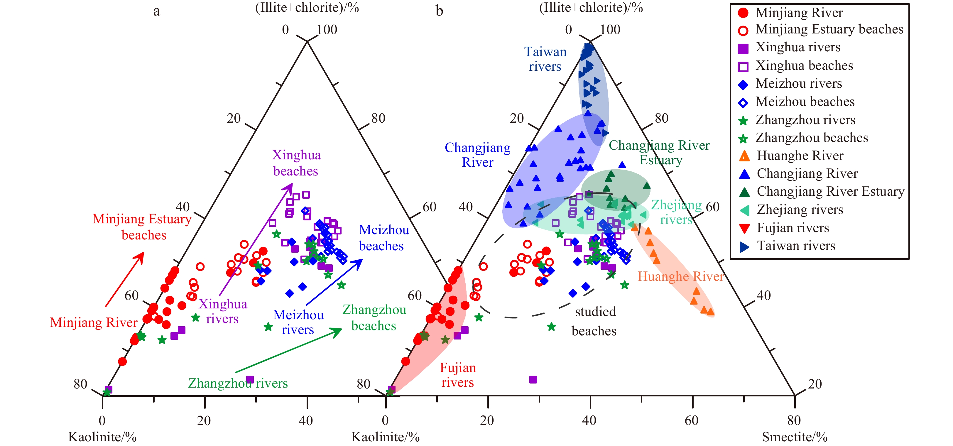
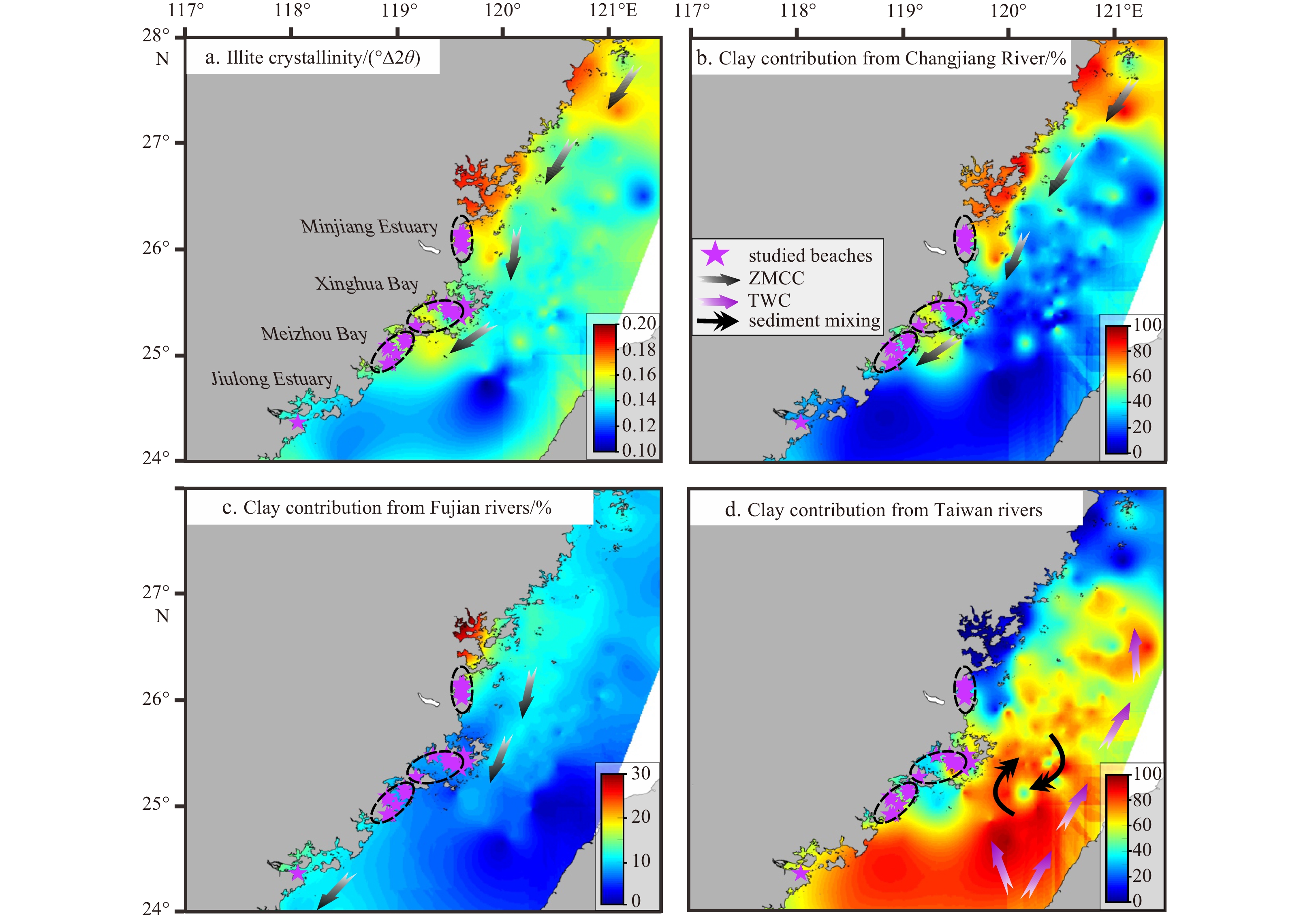
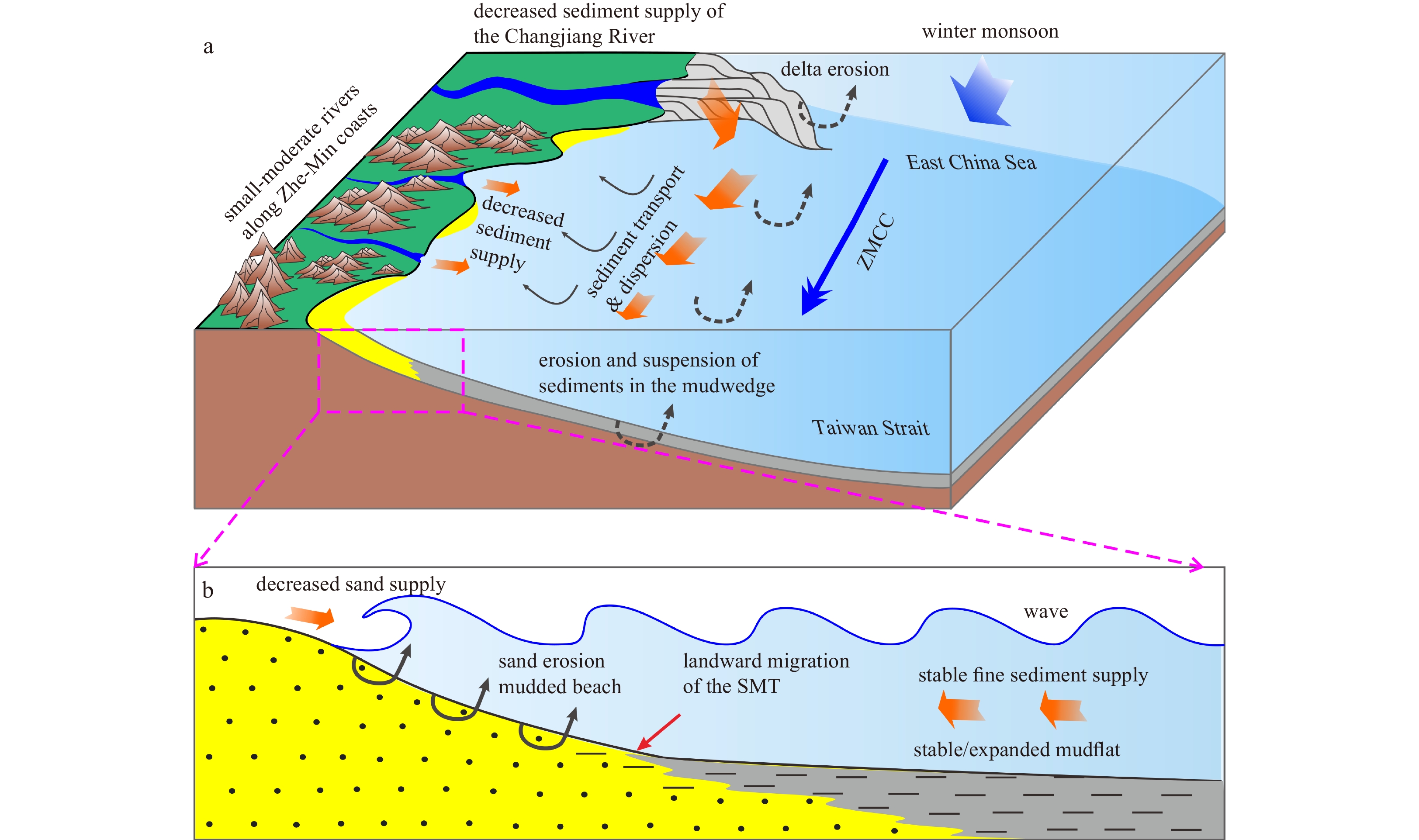
The clay mineralogy of 28 sandy-muddy transitional beach (SMT-Beach) sediments and surrounding mountain river sediments along the coasts of southeastern China was systematically investigated to reveal the sediment source-to-sink process variations of such beaches and their morphological indications. The results show that the clay mineral assemblages of these SMT-Beaches mainly comprise of almost equal illite (~30%), kaolinite (~28%), chlorite (~22%), and smectite (~20%) contents. From the surrounding mountain rivers to the SMT-Beaches, clay mineral assemblages show distinct spatial changes characterized by a large decrease (~40%) in kaolinite, whereas the other three clay minerals present relative increases, especially clear for smectite. The muddy sediment sources of SMT-Beaches inferred from the clay mineralogy are mainly derived from nearby mountain rivers coupled with long-distance transport and penetration of the Changjiang River. The sandy sediments of these beaches are predominantly sourced from nearby mountain rivers, the weathering products of surrounding rocks in both mainland and island environments, and erosion of the “Old Red Sand” and “Red Soil Platform”. However, the sandy sediment sources of the SMT-Beaches are largely reduced because of the remarkable decrease in the river fluvial supply associated with intensive human activities such as dam construction and coastal reclamation. Subsequently, the sandy sections of SMT-Beaches present clear erosion and have revealed by both time series remote sensing images and a compilation of published literature. In contrast, the muddy sediment supply of SMT-Beaches is temporarily stable and relatively constant, resulting in the landward migration of the mudflats with relative transgression or accumulation. These findings highlight that the natural evolution processes of SMT-Beaches have been greatly reshaped by intensive human activities.
Typhoon vs. cold wave: a comparative assessment of geomorphic response and boulder displacement using RFID technology
Lingbo Li, Feng Cai, Hongshuai Qi, Lulu Qiao, Shaohua Zhao, Gen Liu, Jianhui Liu
2023, 42(7): 25-40. doi: 10.1007/s13131-022-2083-4
Abstract:
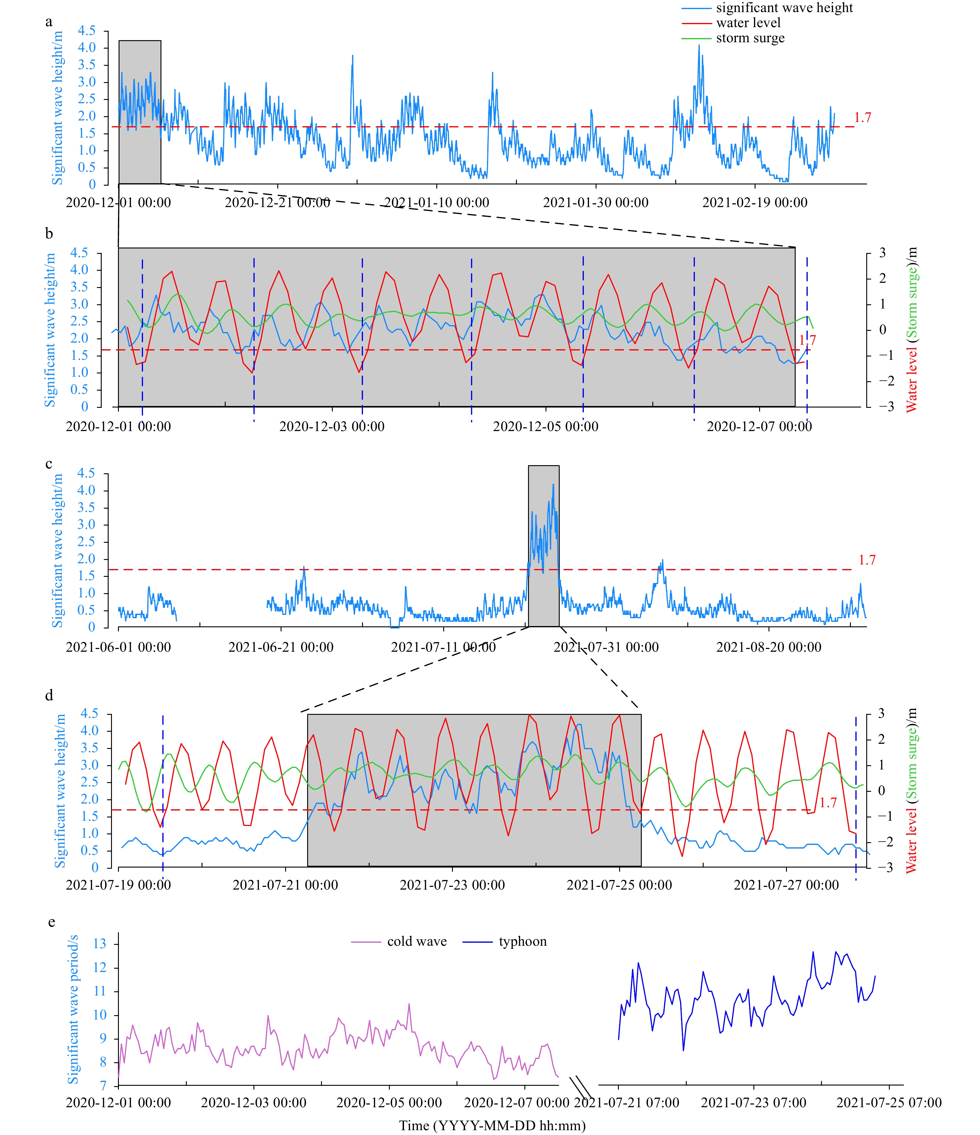
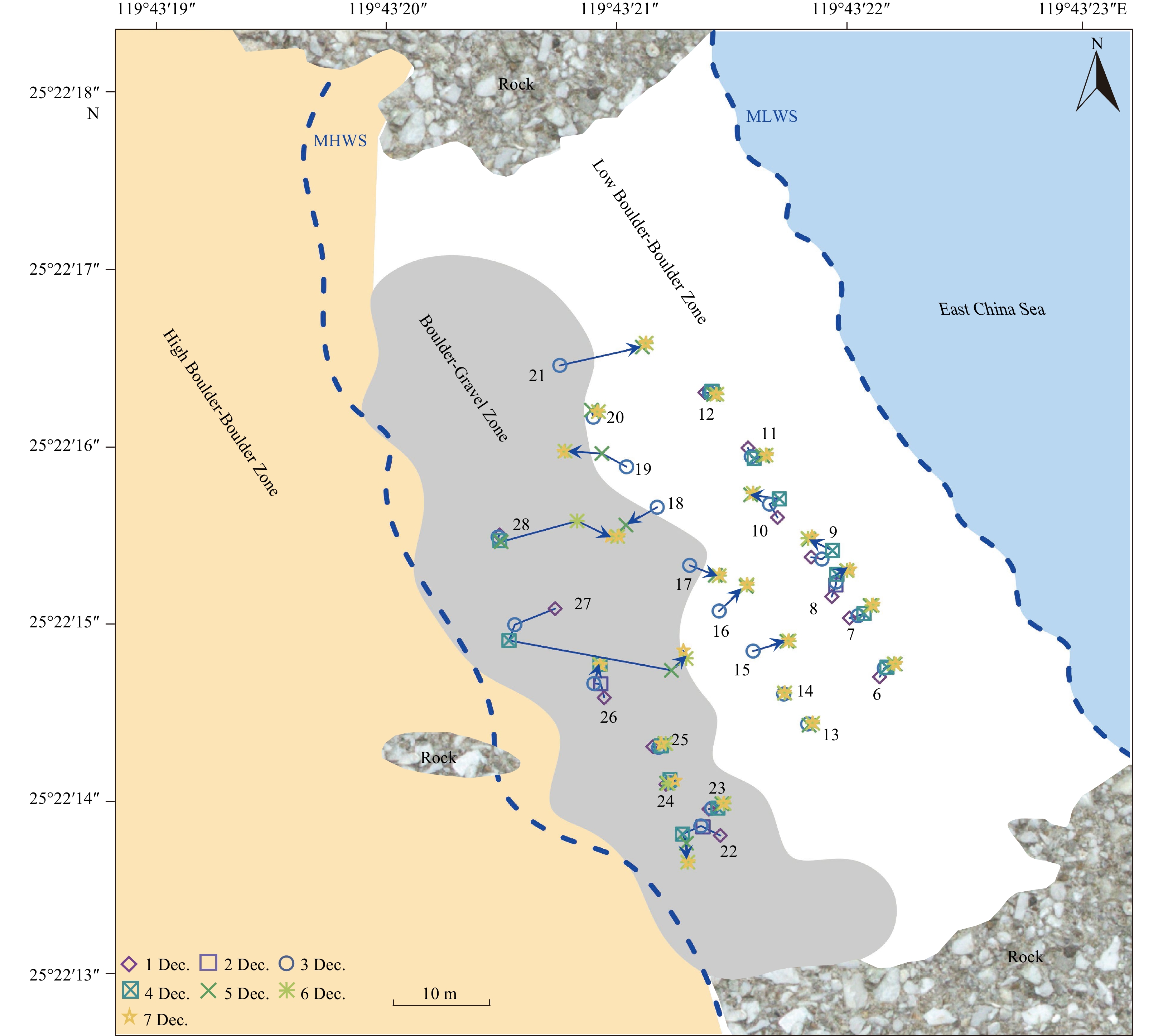
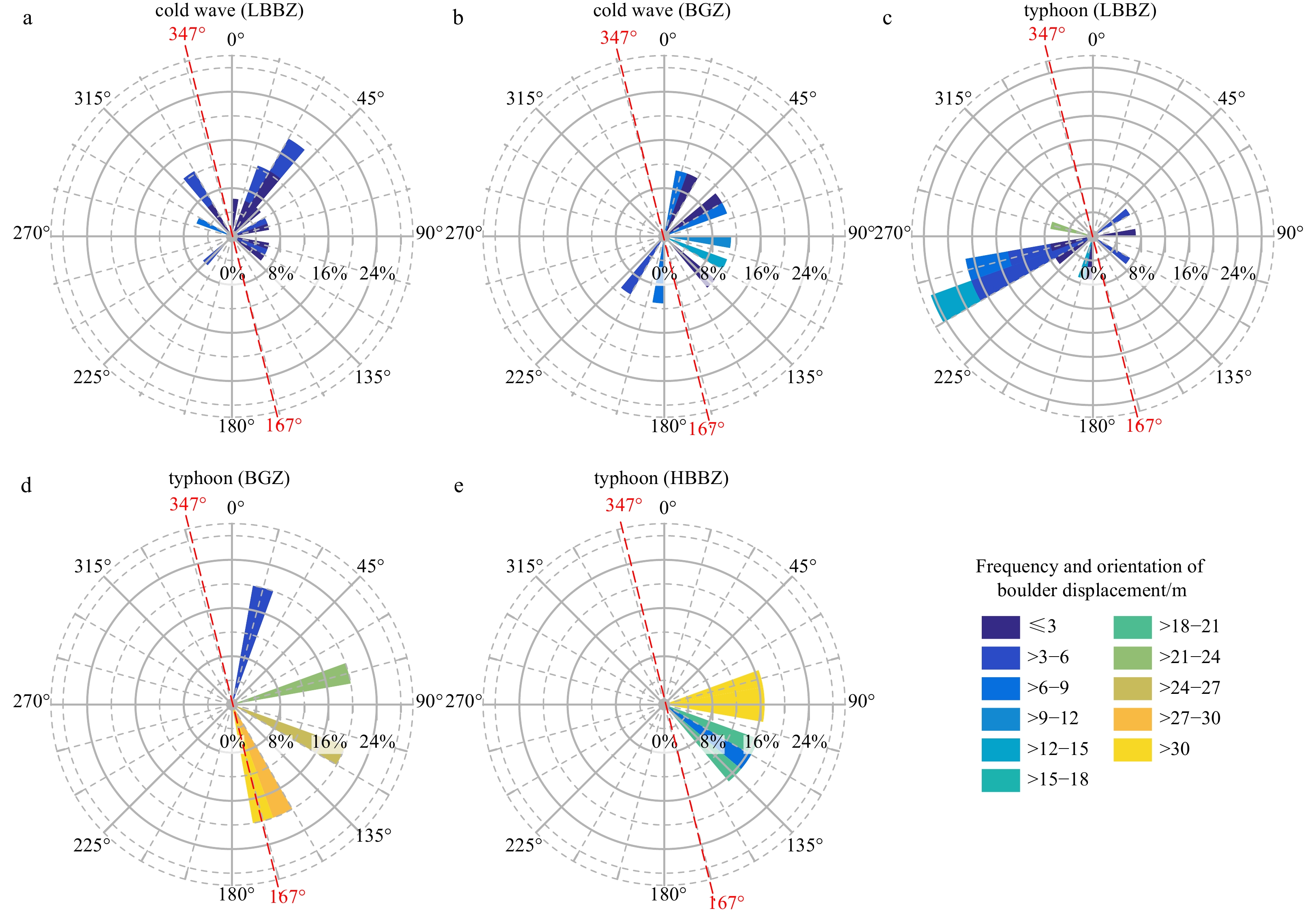
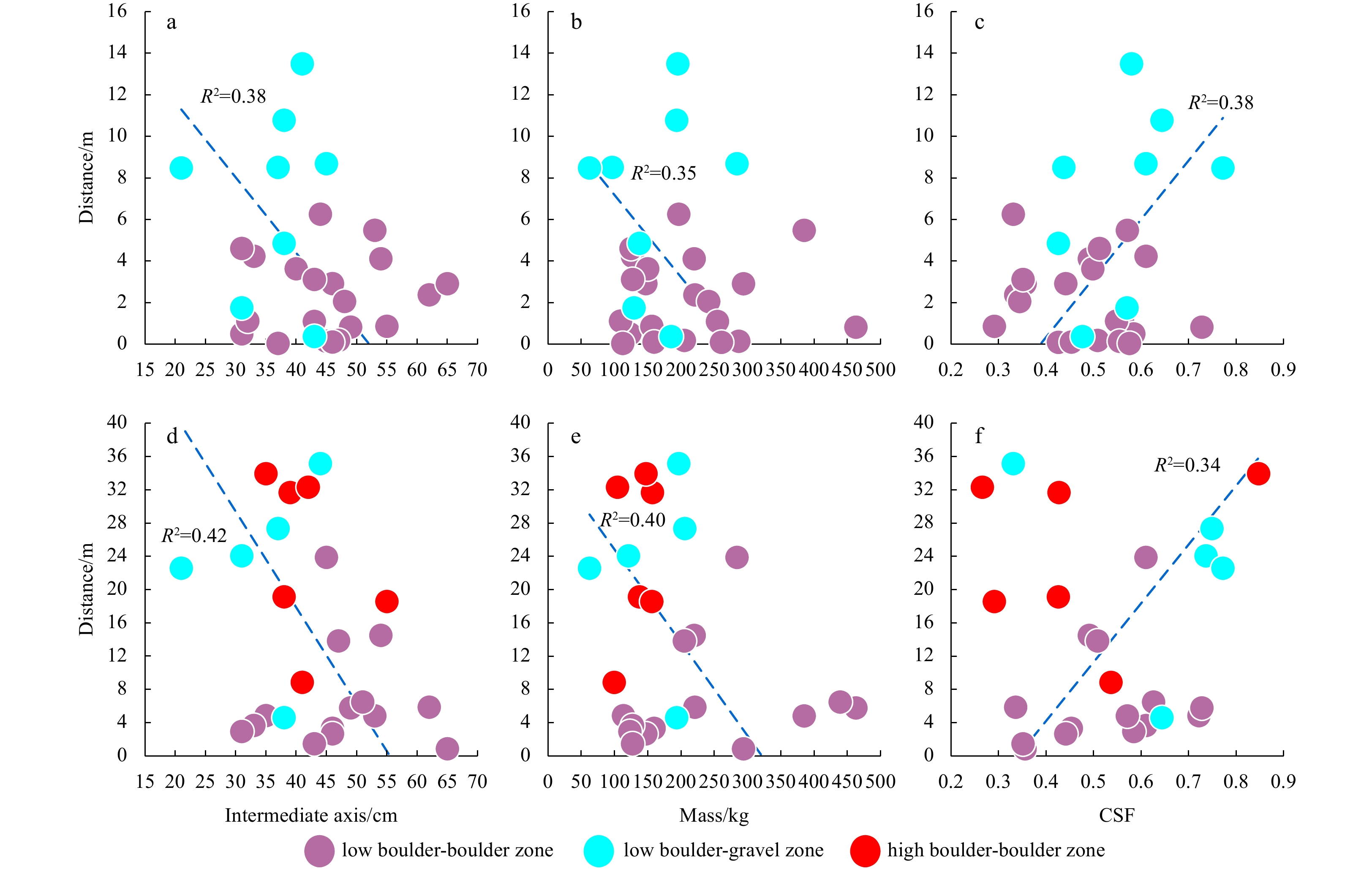
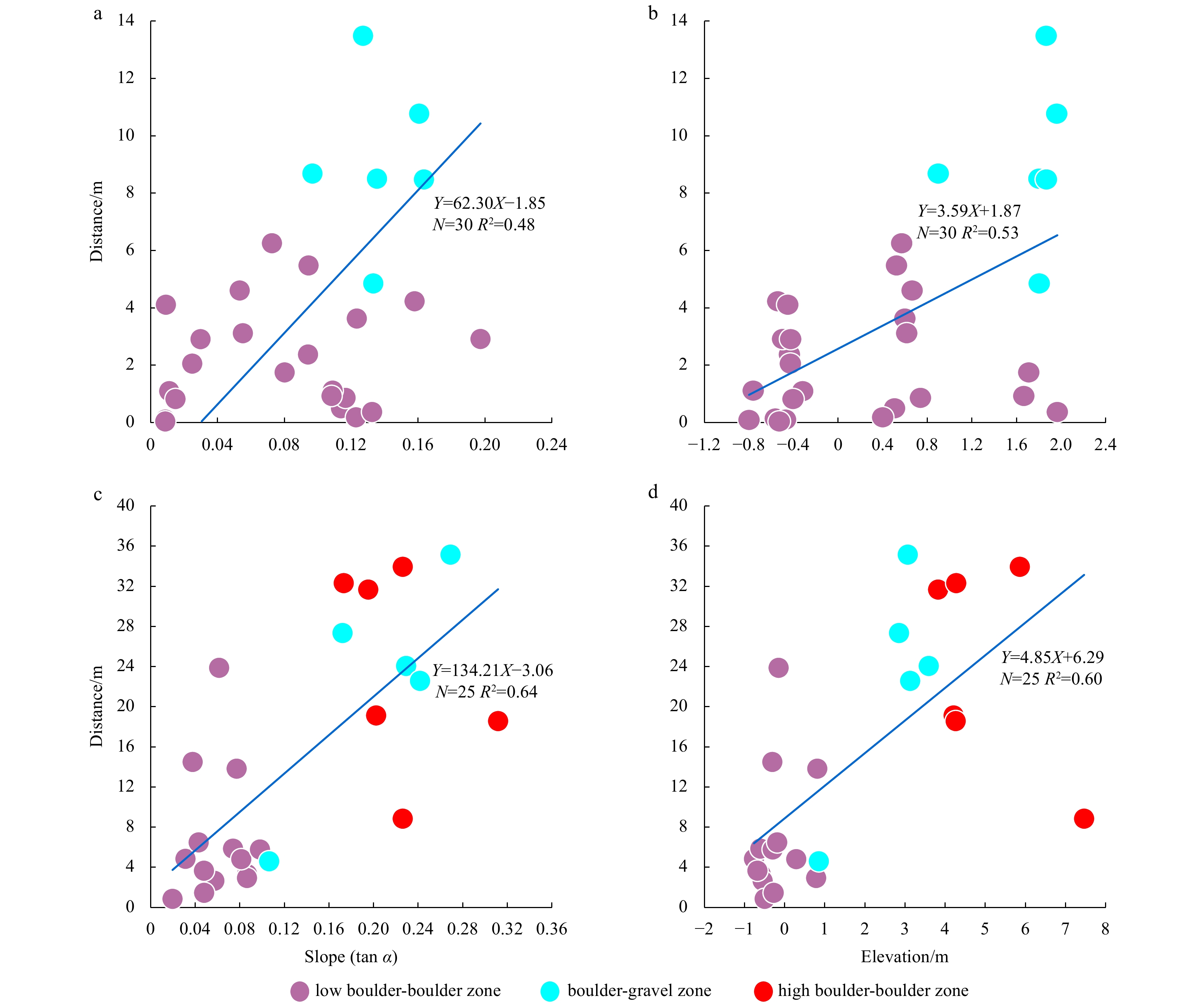
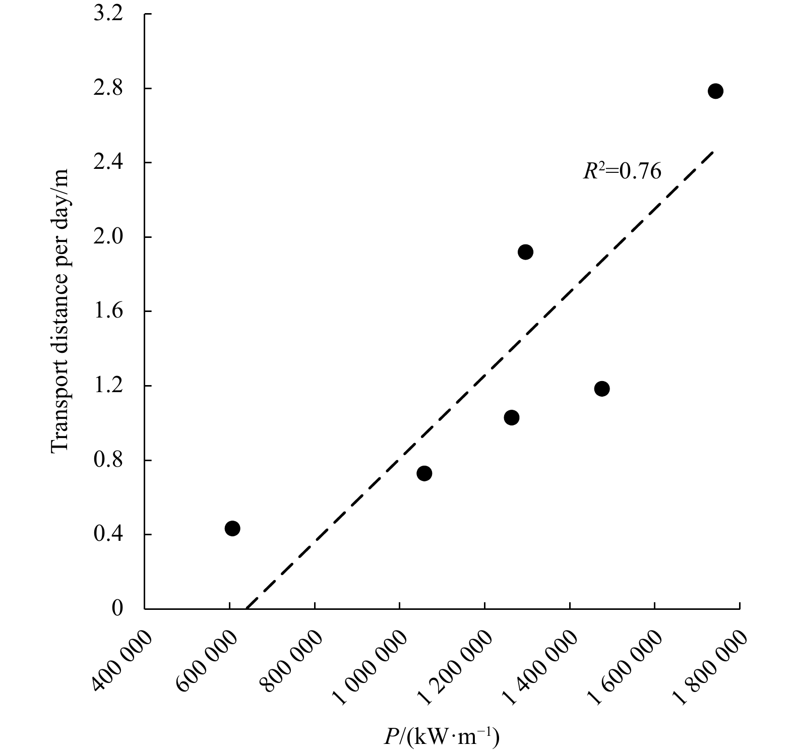
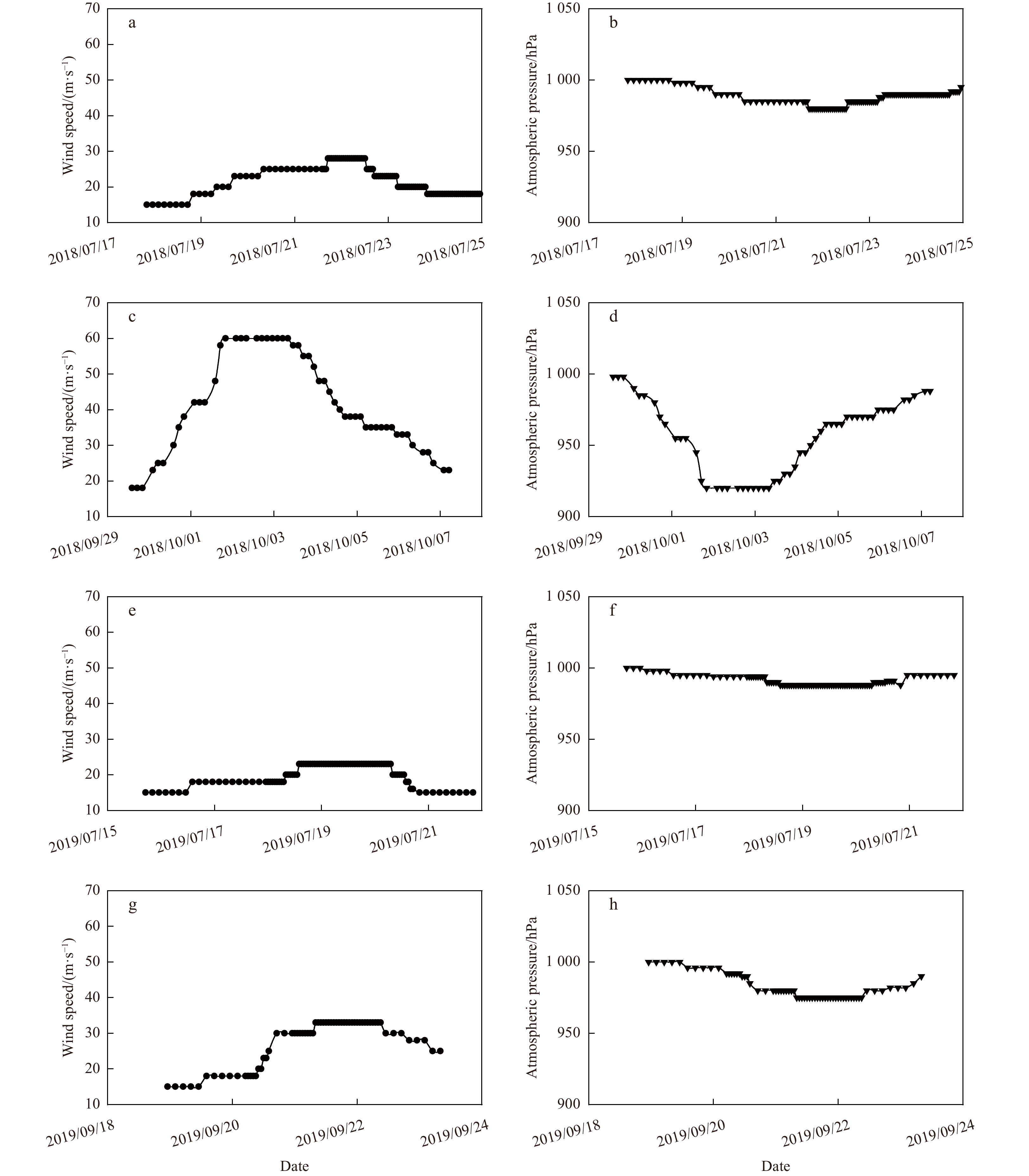
Extreme storm events in coastal zones play significant roles in shaping the morphology of boulder beaches. However, boulder displacement and the geomorphological evolution of boulder beaches driven by different extreme storm events, especially typhoon events, remain poorly understood. Thus, boulder displacement and the geomorphic response on a boulder beach in Fujian, southeastern China, were explored before, during and after a cold wave event (Dec. 1–7, 2020) and before and after Typhoon In-Fa (Jul. 19–27, 2021), a large tropical storm. This was achieved by tracking 42 tagged boulders distributed in the intertidal and supratidal zones using Radio Frequency Identification (RFID) and topographic surveys using real-time kinematic techniques, respectively. The results showed obvious disparities in boulder displacement in different geomorphic zones due to cold wave and typhoon events that were mainly characterized by migration magnitude, range, direction, and mode of transport. The typhoon event led to rapid and substantial changes in the overall morphology of the boulder beach, while the cold wave event impacted the intertidal morphology of the boulder beach to only a small extent. The surrounding structure of boulders, beach slope and beach elevation had a combined dominant effect on boulder displacement under the same extreme event. Hydrodynamic factors (effective wave energy fluxes, incident wave direction, storm surge and water level) had dominant effects on boulder displacement during different extreme events. In terms of a single event, the magnitude of the boulder displacement driven by the typhoon was much greater than that driven by the cold wave. However, considering the frequency and duration of cold waves in winter, the impact of multiple consecutive cold waves on the geomorphology of the boulder beach cannot be ignored in this study area. Alternating and repeated interactions between these two processes constitute the complete geomorphic evolution of the boulder beach. This study contributes to improved predictions of the morphodynamic response of boulder beaches to future storms, especially large tropical storms, and facilitates better coastal management.
An investigation of the morphodynamic change of reef islands under monochromatic waves
Yu Yao, Baobao Zhou, Zhongwei Zhao, Xianjin Chen, Long Chen
2023, 42(7): 41-50. doi: 10.1007/s13131-023-2156-z
Abstract:
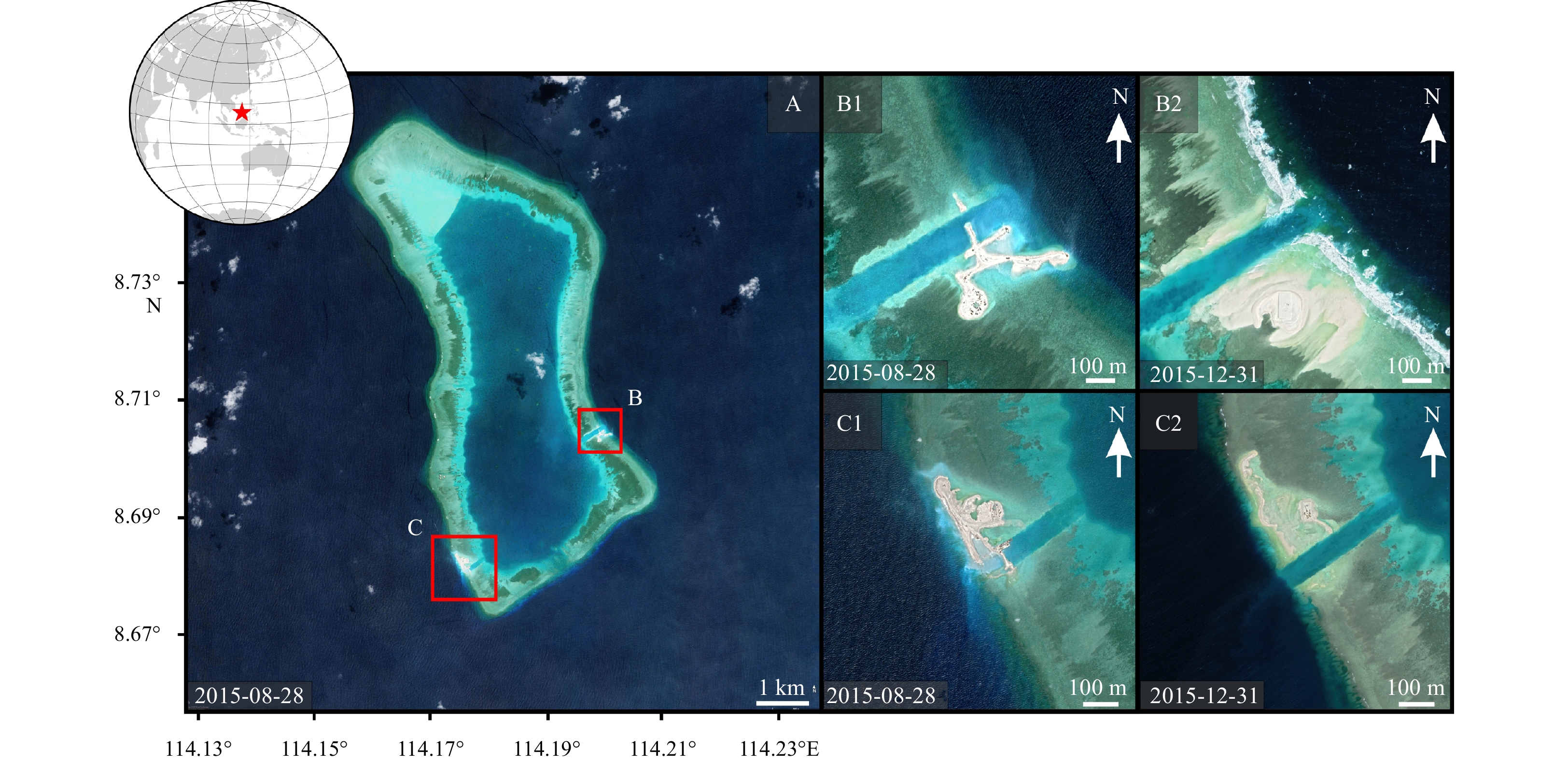
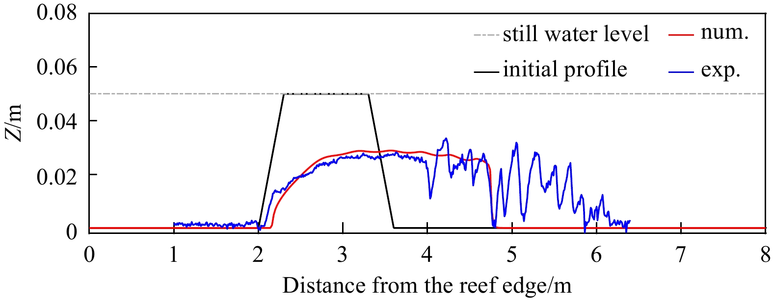
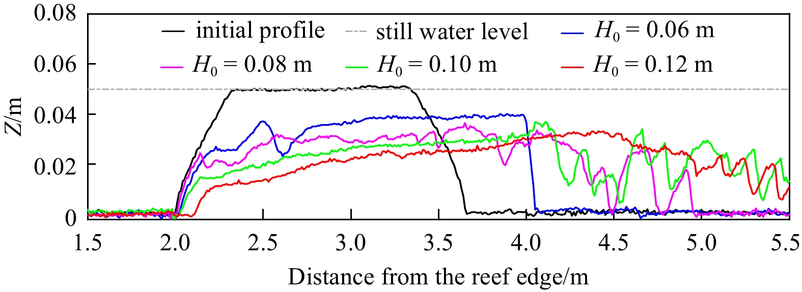
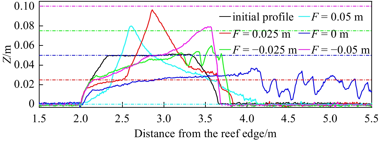
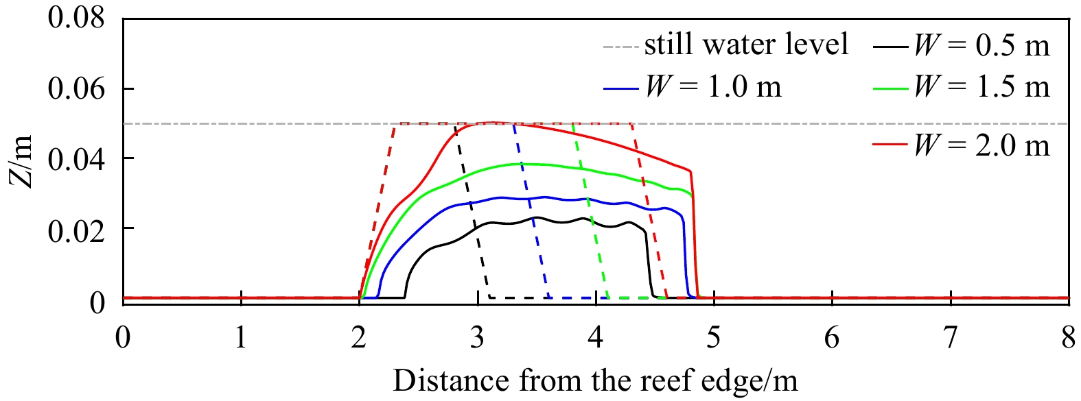
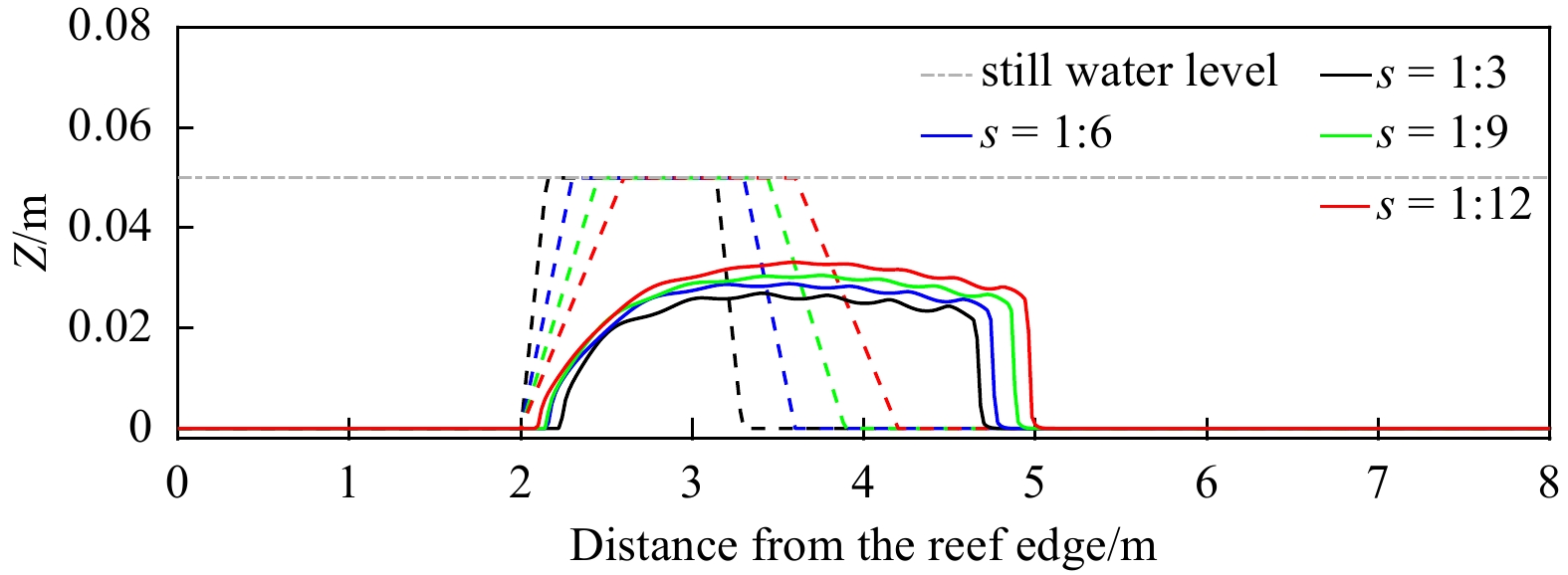
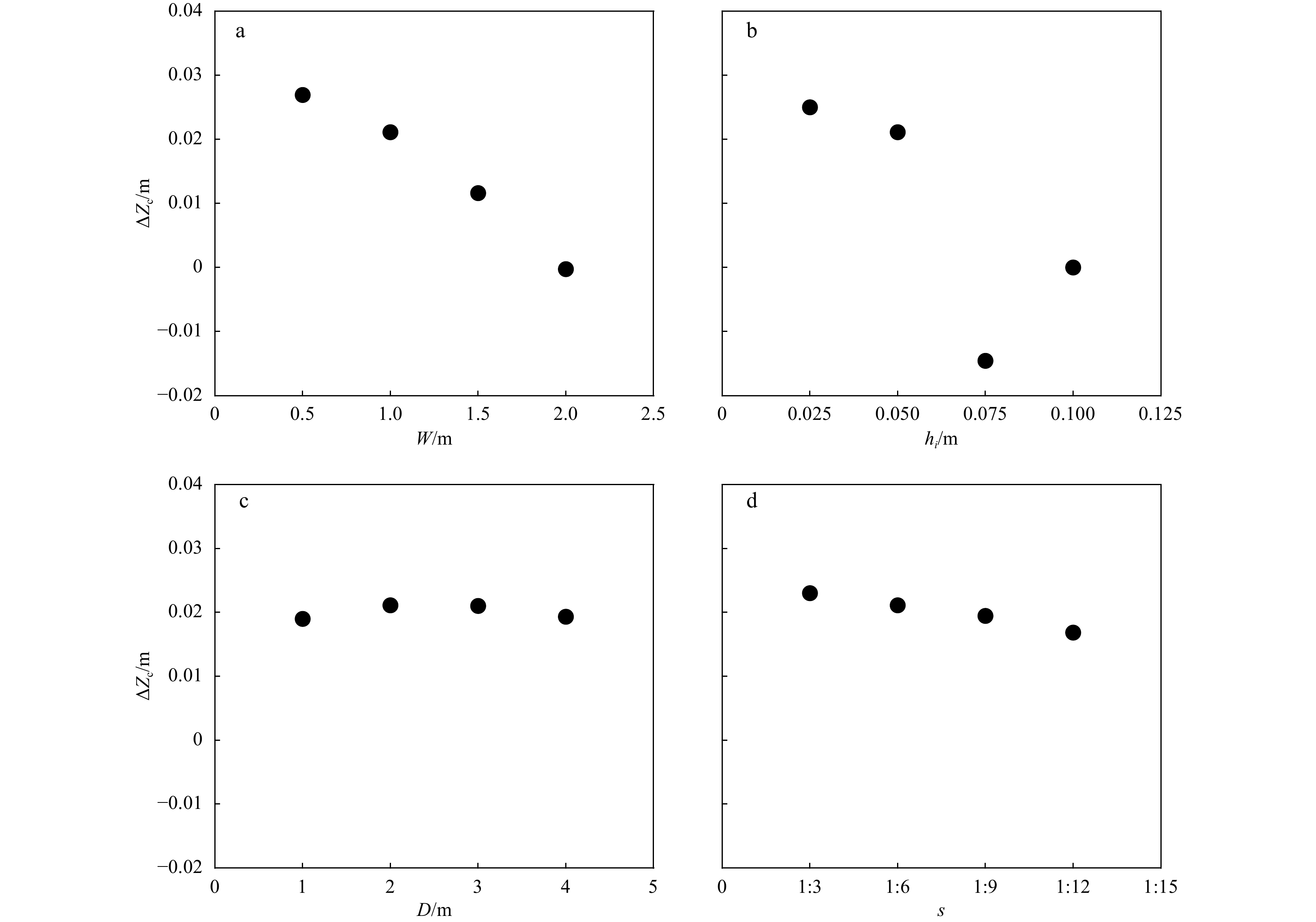
The persistence and habitability of coral reef islands in future extreme oceanographic conditions has received increasing attention in the recent decade, concerning that the sea level rise (SLR) and more frequent and intense storms in the context of global climate change are expected to destabilize those islands. Here, we conduct a set of wave-flume laboratory experiments focusing on the morphodynamic change of reef islands to varying ocean forcing conditions (wave height and SLR). Subsequently, a phase-resolving XBeach numerical model is adopted to simulate the monochromatic wave process and its associated sediment dynamics. The adopted model is also firstly validated by laboratory experimental results as reported in this study. It is then used to examine the impacts of island morphological factors (island width, island height, island location and island side slope) on the island migration. The combined laboratory/physical and numerical experiment outputs suggest that reef islands can accrete vertically in response to the sea level rise and the increased storminess.
Morphodynamic response of an embayed beach to different typhoon events with varying intensities
Lianqiang Shi, Junli Guo, Shenliang Chen, Yang Chang, Daheng Zhang, Zhaohui Gong
2023, 42(7): 51-63. doi: 10.1007/s13131-023-2164-z
Abstract:
Beach erosion has occurred globally in recent decades due to frequent and severe storms. Dongsha beach, located in Zhujiajian Island, Zhejiang Province, China, is a typical embayed sandy beach. This study focused on the morphodynamic response of Dongsha beach to typhoon events, based on beach topographies and surficial sediment characteristics acquired before and after four typhoon events with varying intensities. The four typhoons had different effects on the topography and sediment characteristics of Dongsha beach. Typhoons Ampil and Danas caused the largest (−51.72 m3/m) and the smallest erosion (−8.01 m3/m), respectively. Remarkable alongshore patterns of beach profile volumetric changes were found after the four typhoon events, with more erosion in the southern and central parts of the beach and few changes in the northern part. Grain size coarsening and poor sorting were the main sediment patterns on the beach influenced by different typhoons. Typhoons that occurred in the same year after another typhoon enhanced the effect of the previous typhoon on sediment coarsening and sorting variability, but this cumulative effect was not found between typhoons that occurred during different years. A comparison of the collected data revealed that the topographic state of the beach before the typhoon, typhoon characteristics, and tidal conditions were possible reasons for the difference in the responses of Dongsha beach to typhoon events. More severe beach erosion was caused by typhoons with higher intensity levels and longer durations, and high tide levels during typhoons can determine the upper limit of the beach profile erosion site. Taken together, these results can be used to improve beach management for storm prevention.
Dynamic geomorphology and storm response characteristics of the promontory-straight beach—a case of Gulei Beach, Fujian
Chao Cao, Zijian Mao, Feng Cai, Hongshuai Qi, Jianhui Liu, Gang Lei, Shaohua Zhao, Gen Liu
2023, 42(7): 64-78. doi: 10.1007/s13131-023-2225-3
Abstract:
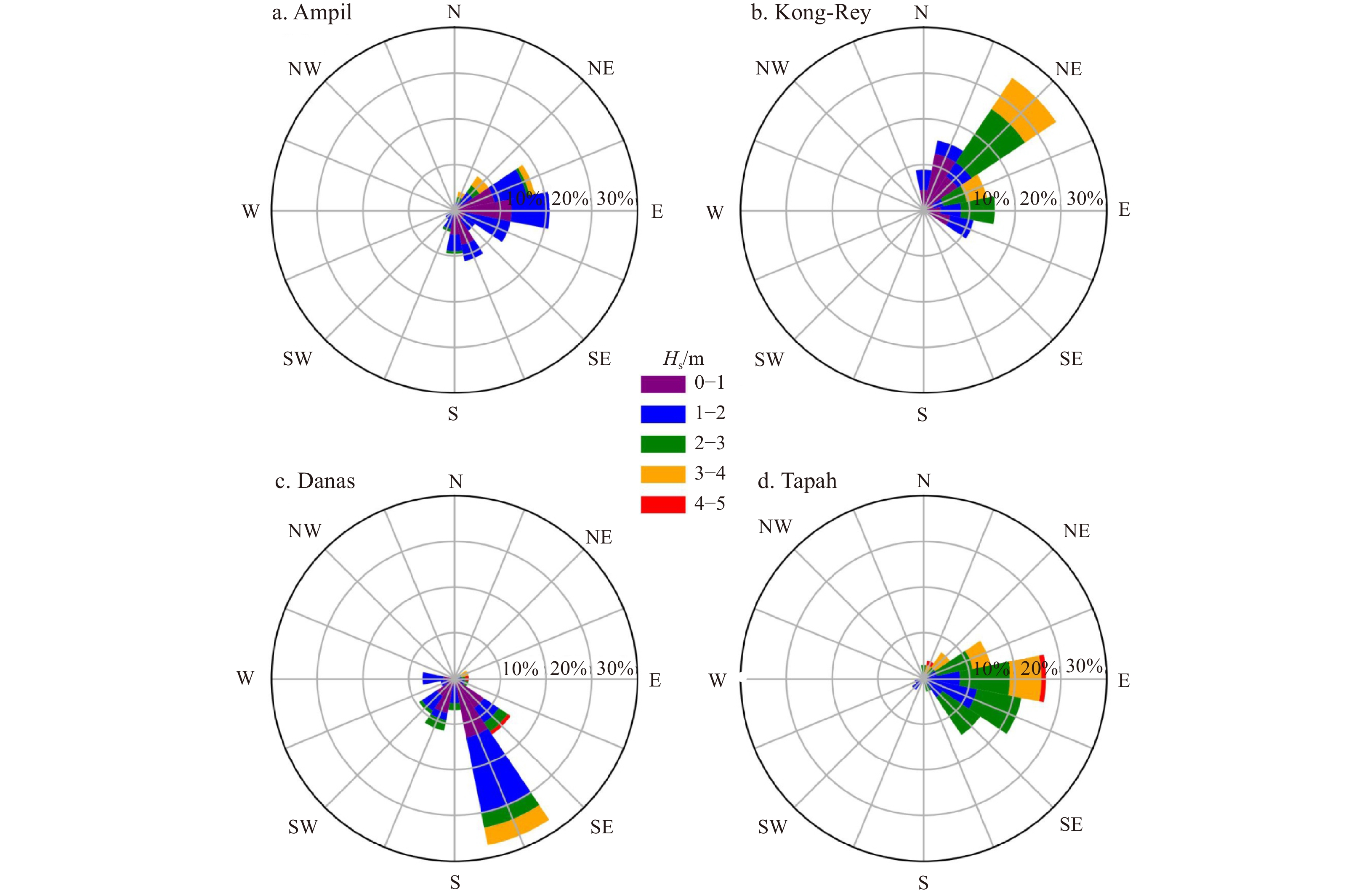
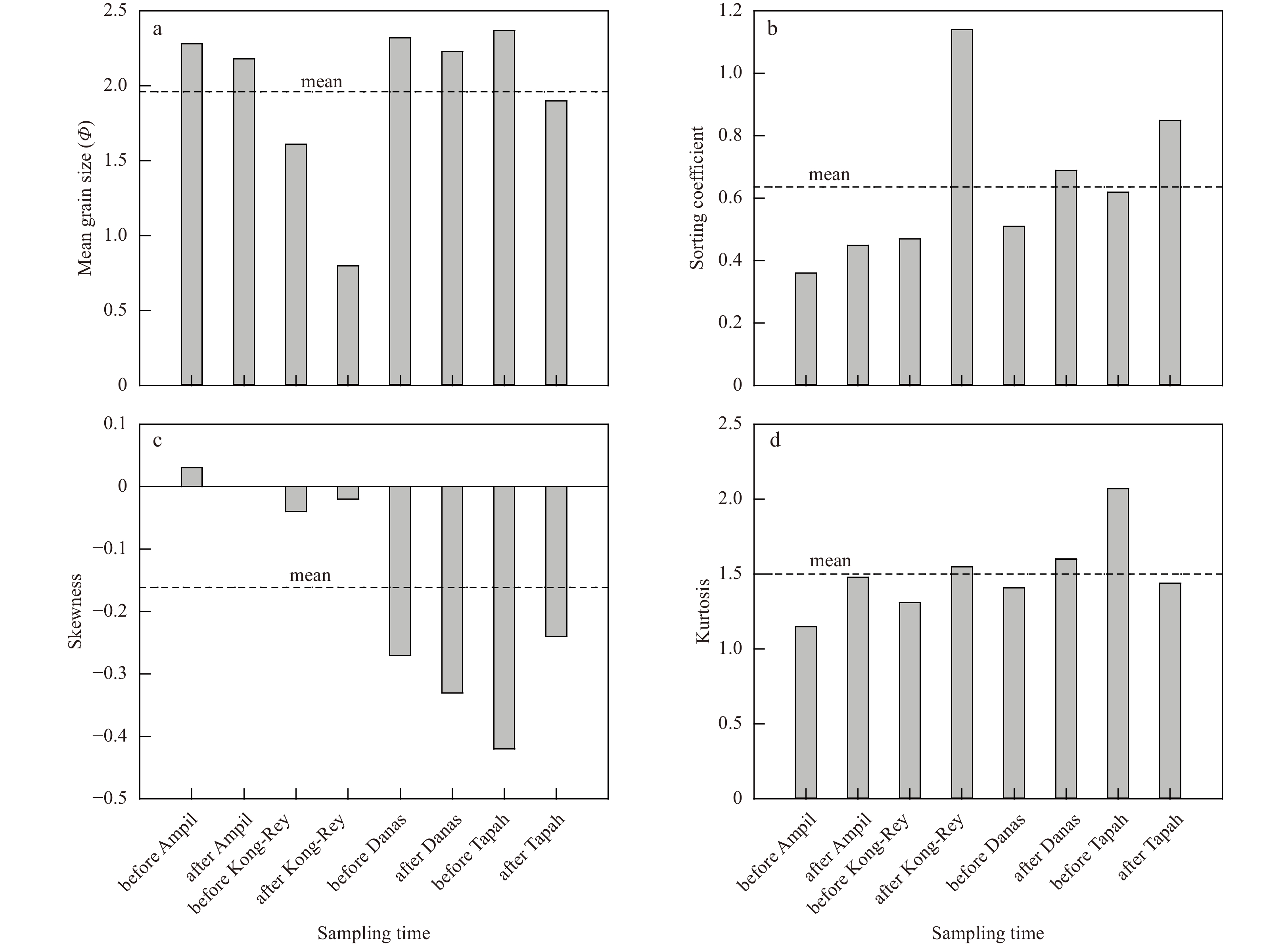
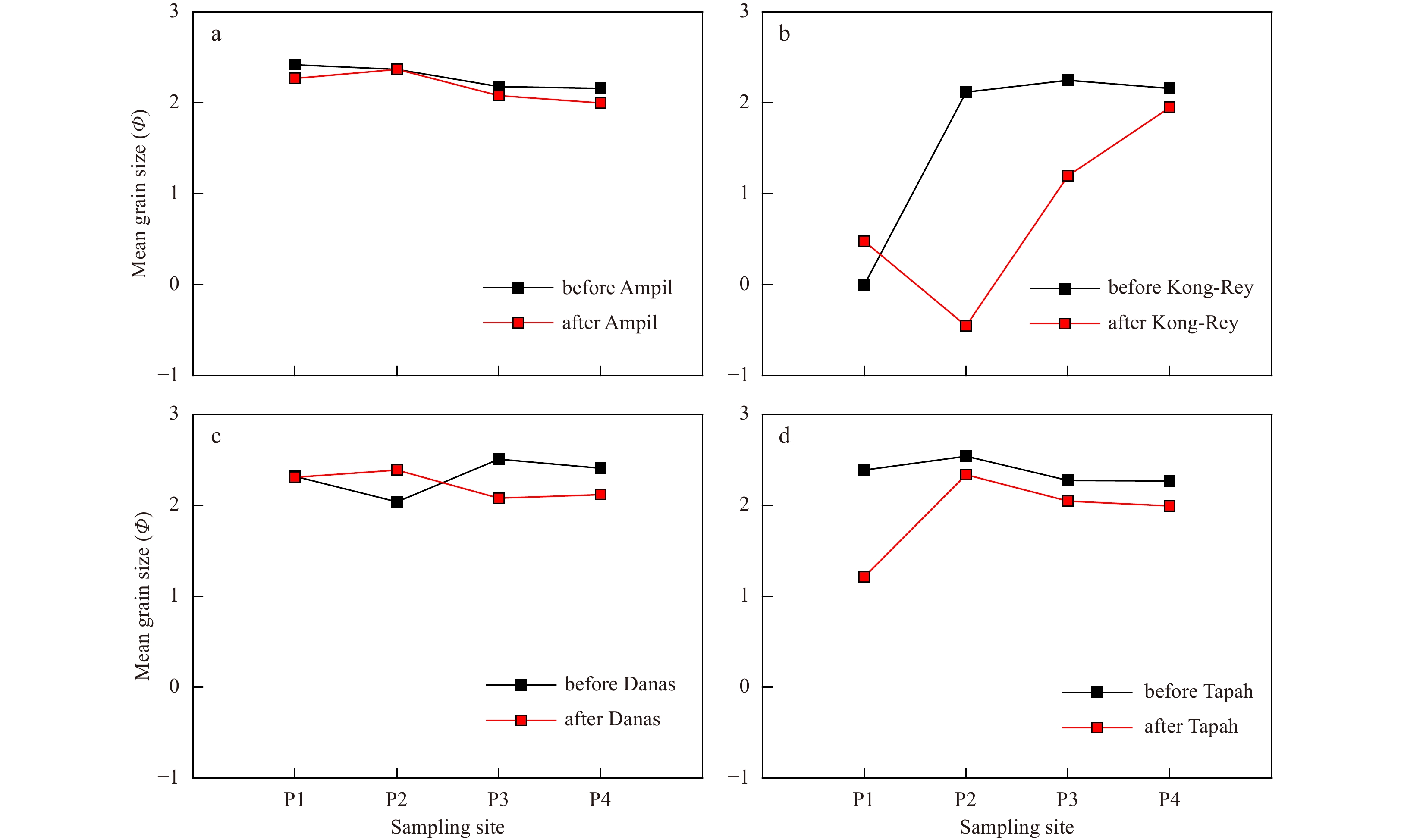
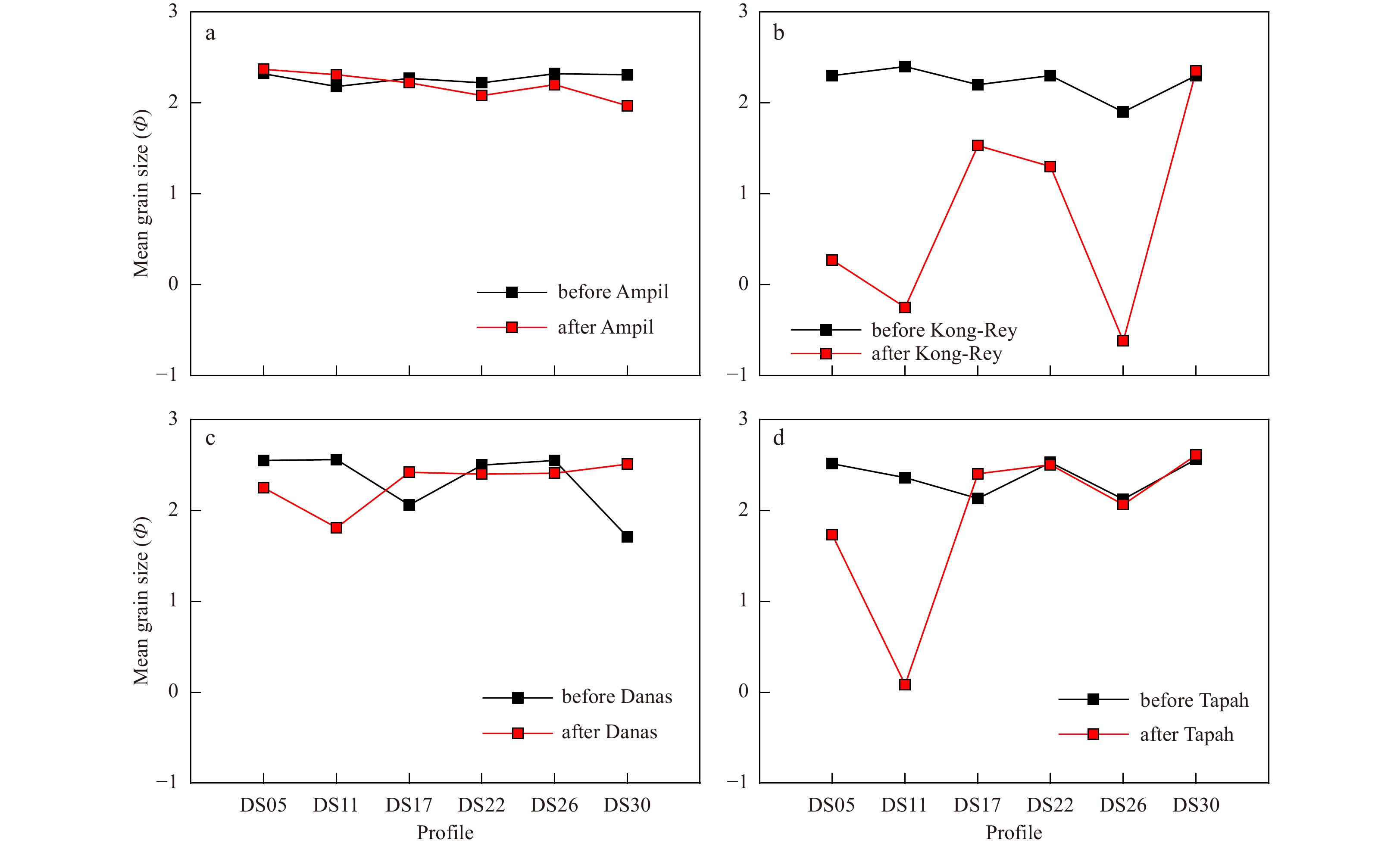
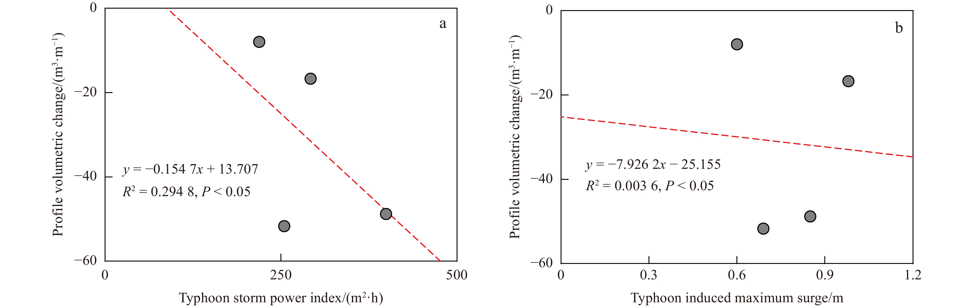
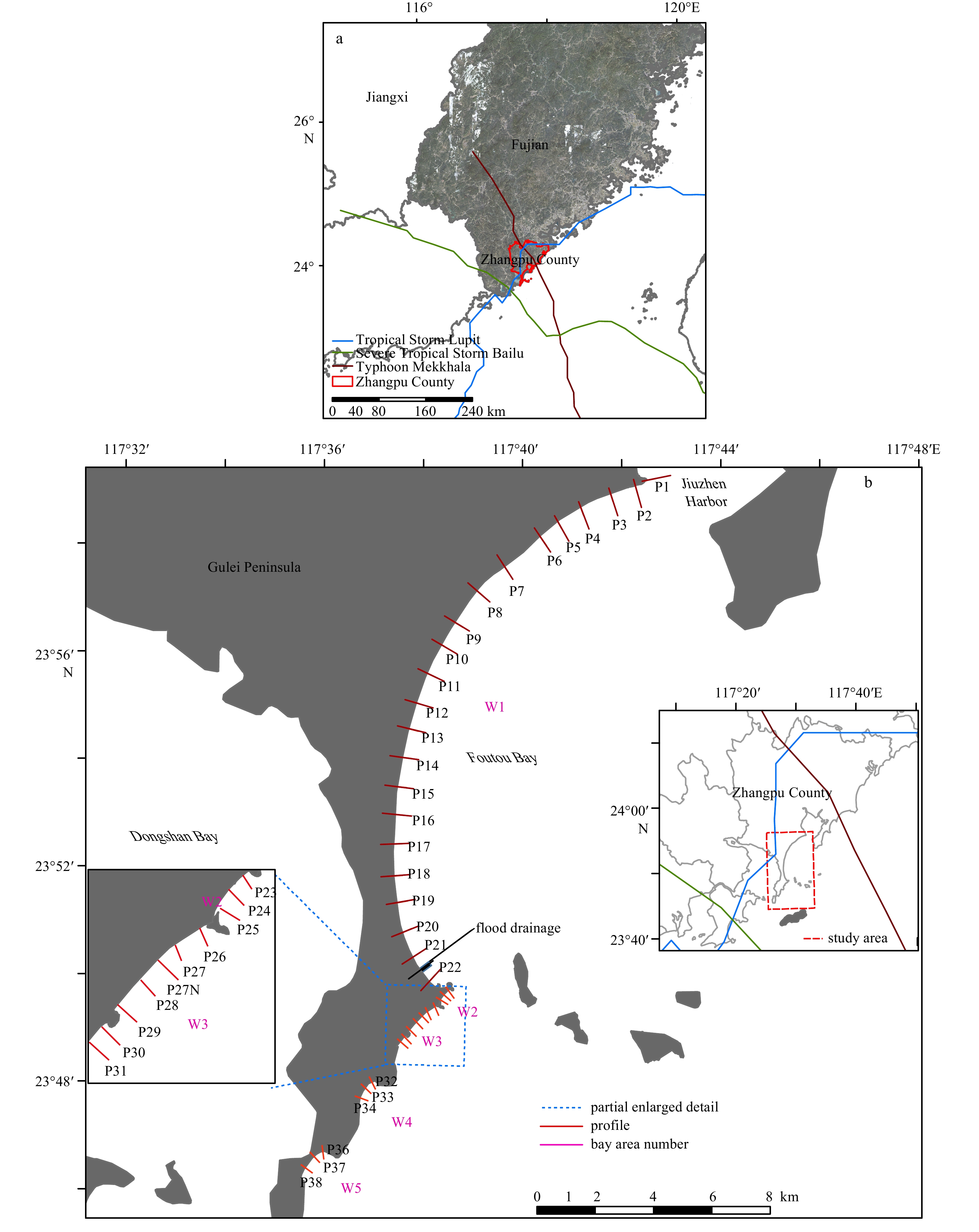
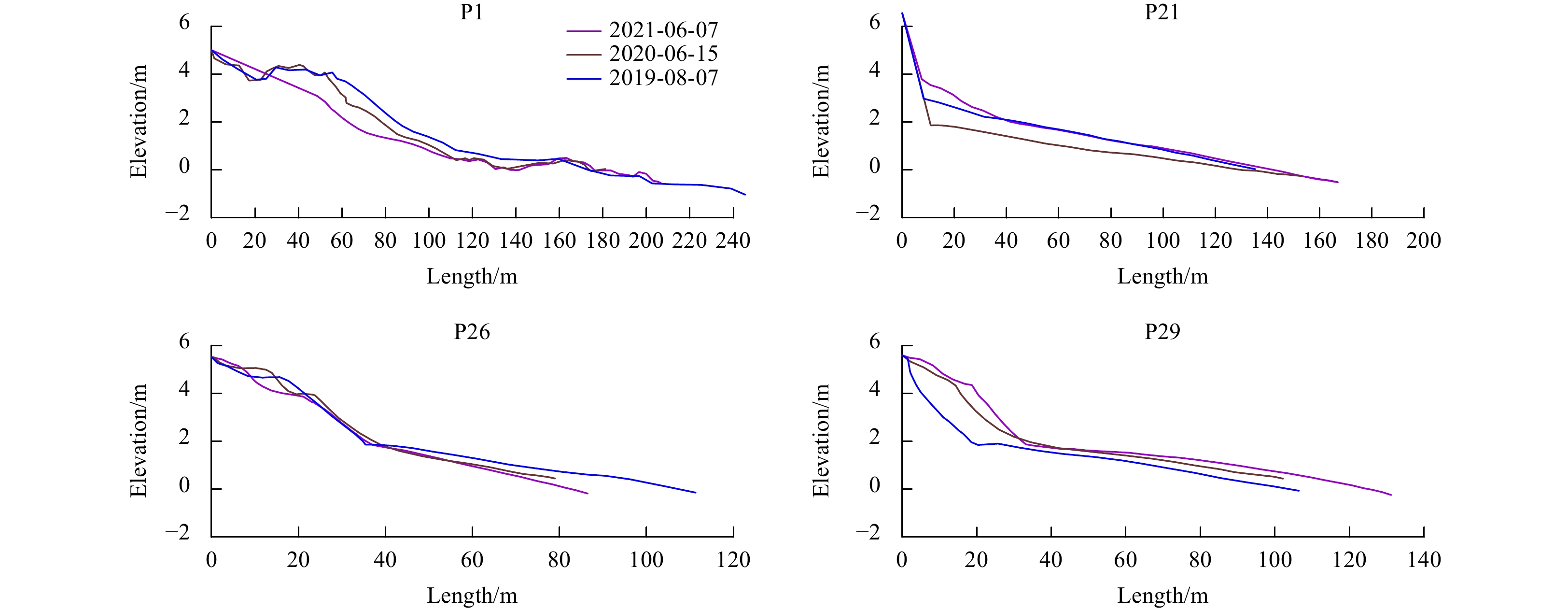
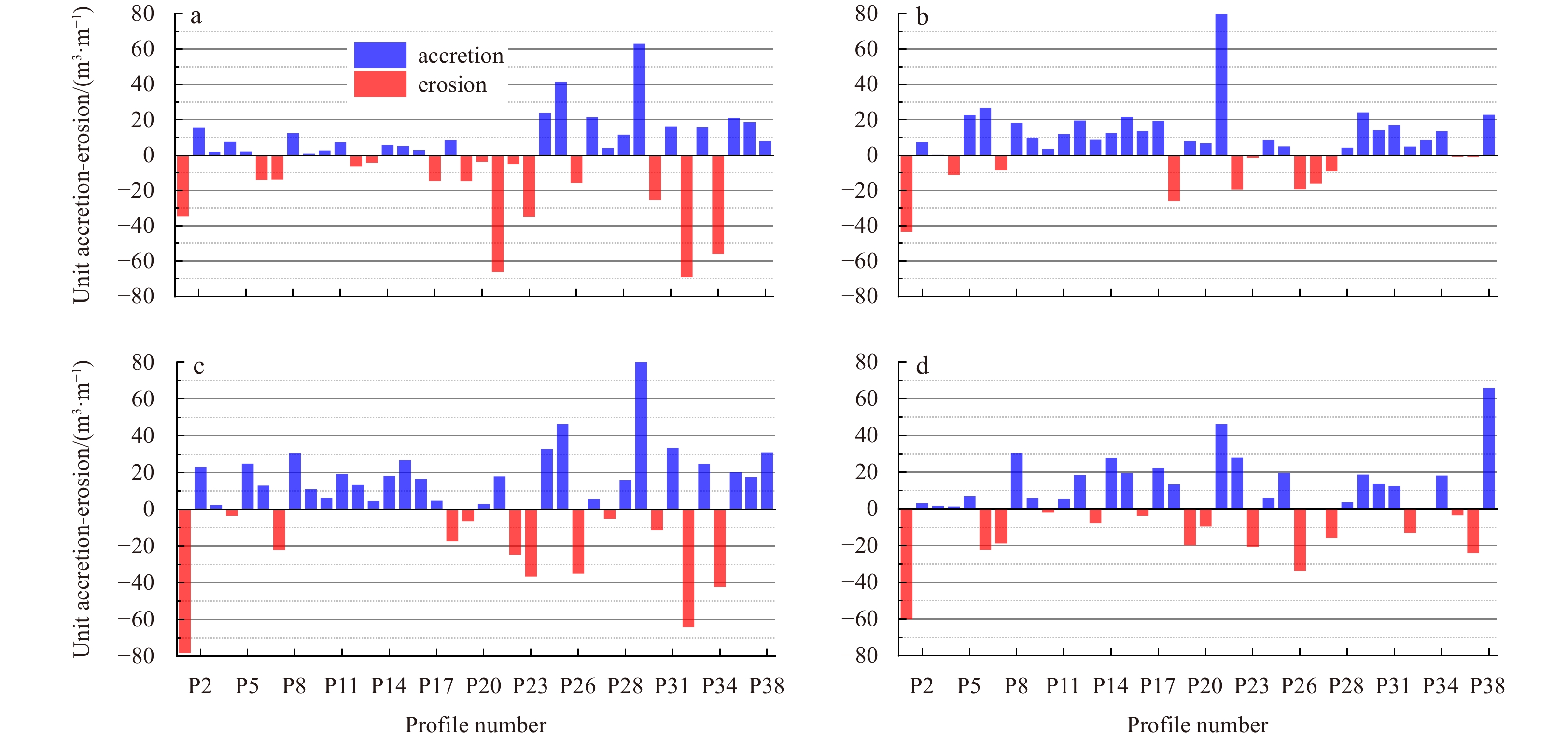
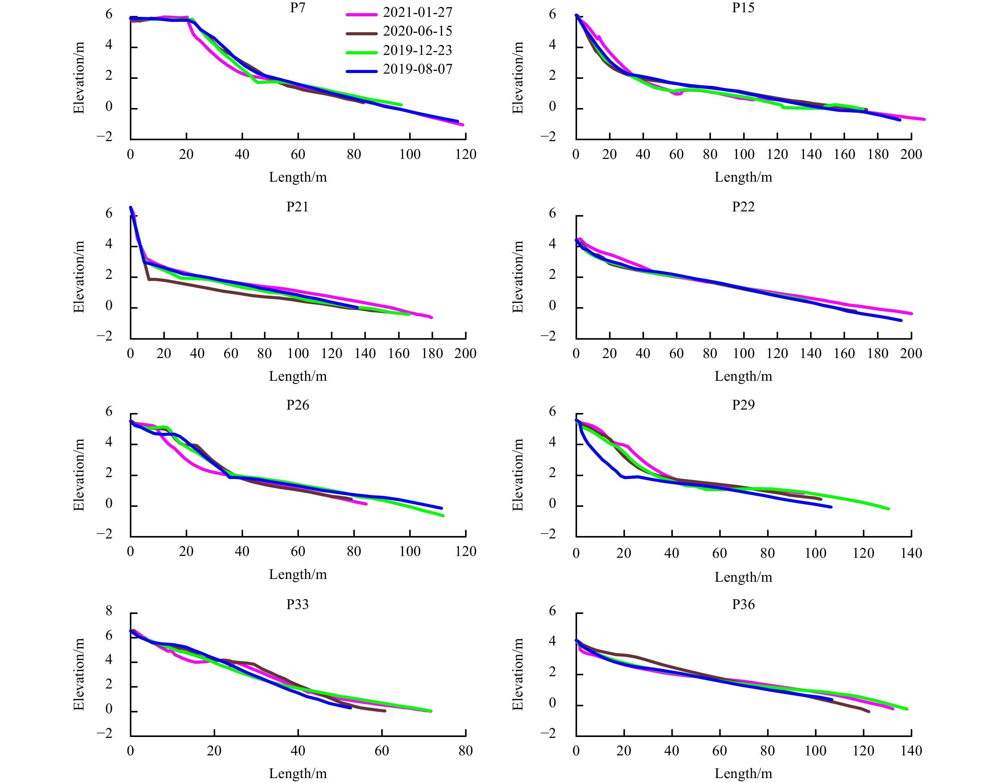
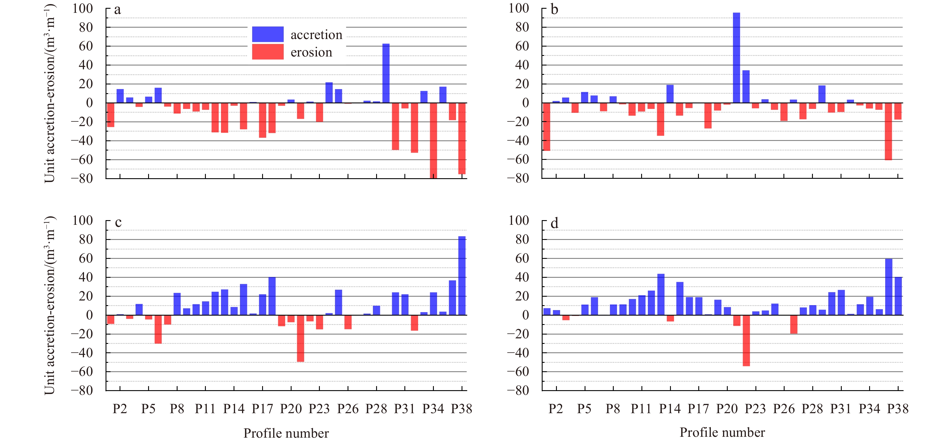
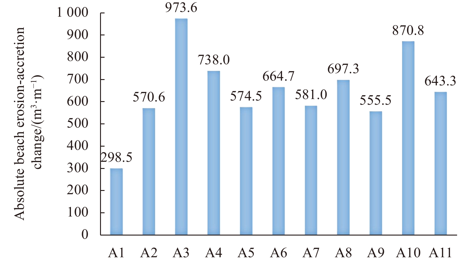
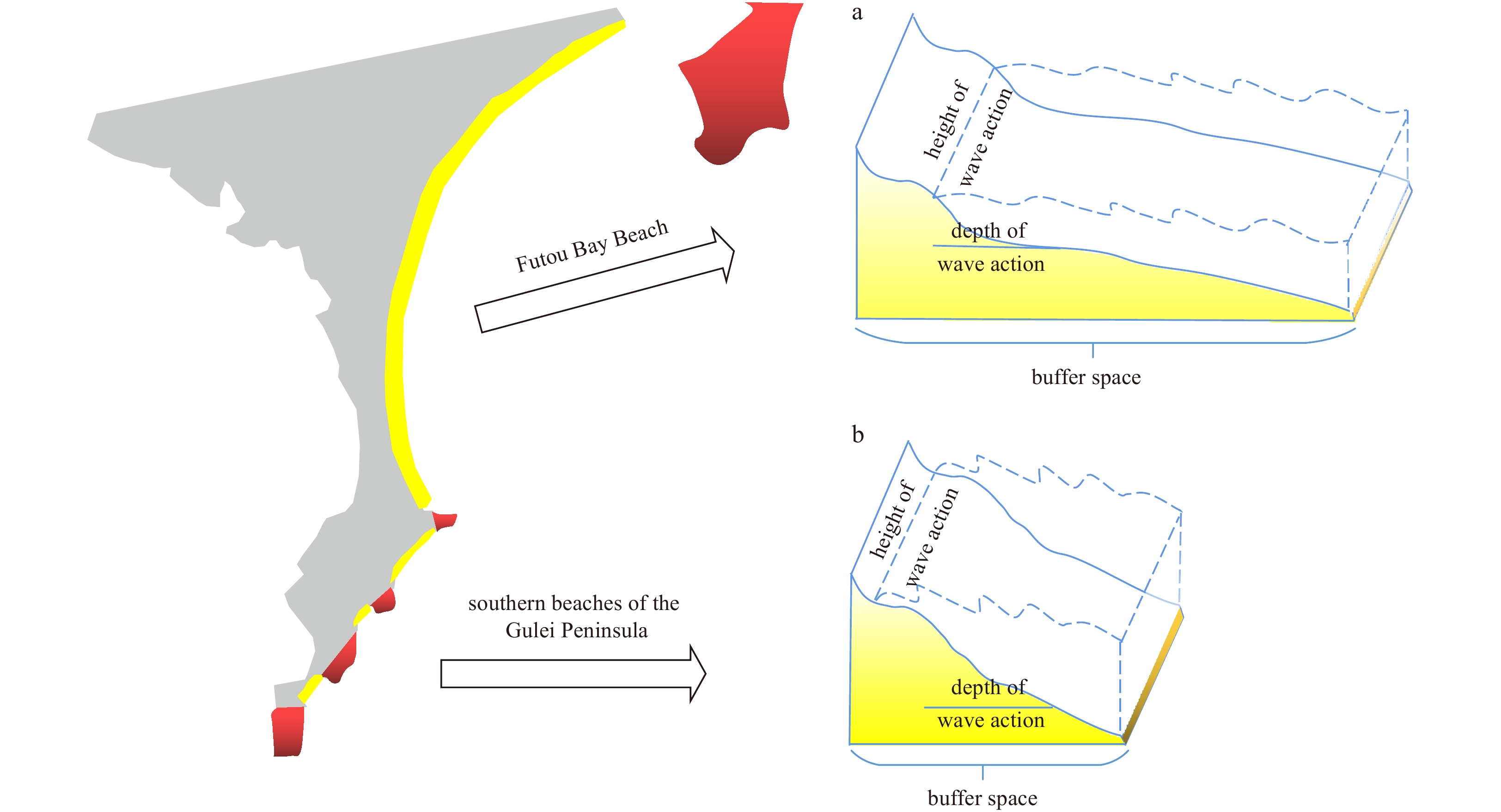
As one of the main areas of tropical storm action in the northwestern Pacific Ocean, South China experiences several typhoons each year, and coastal erosion is a problem, making the area a natural testing ground for studying the dynamic geomorphological processes and storm response of promontory-straight coasts. This study is based on three years of topographic data and remote sensing imagery of Gulei Beach and uses topographic profile morphology, single width erosion-accretion and mean change, combined with the Coastsat model to quantify the seasonal and interannual variability and storm response of the beach and to explain the evolution of shoreline change and beach dynamics geomorphology in the last decade. Gulei Beach has been in a state of overall erosion and local accretion for a long time, with relatively obvious cyclical changes; seasonal changes are also obvious, which are mainly characterized by summer accretion and winter erosion, with accretion at the top of the bay and accretion and erosion on the north and south sides of the bay corner, respectively; the seasonal erosion-accretion volume of the beach profile ranges from −80 m3/m to 95.52 m3/m, and the interannual erosion-accretion volume ranges from −69.09 m3/m to 87.31 m3/m. The response of beaches to typhoons with different paths varies greatly depending on the length, slope, orientation and scale of beach development. The large and gently developing Futou beach is less responsive to storms, while the less developed headlands in the southern Gulei Peninsula are more susceptible to disturbance by external factors and respond more strongly to typhoons. Storm distance is more influential than storm intensity. Under the influence of human activities, obvious erosion hotspots develop during normal weather, but storm processes produce redistribution of beach material patterns, and erosion hotspots disappear after storms. The results of this study enrich the theory of beach dynamics geomorphology and provide technical support for disaster prevention and mitigation, as well as ecological restoration of coastal zones.
Coastal erosion risk assessment of Hainan Island, China
Qianxin Su, Zhiqiang Li, Gaocong Li, Daoheng Zhu, Pengpeng Hu
2023, 42(7): 79-90. doi: 10.1007/s13131-022-2122-1
Abstract:
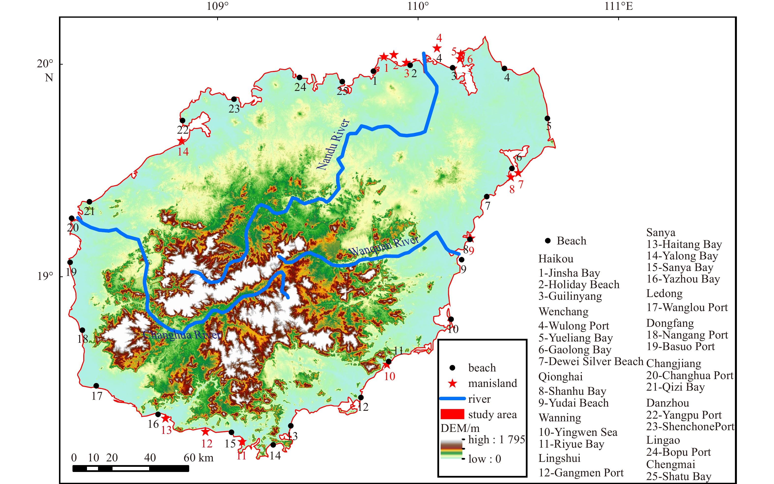
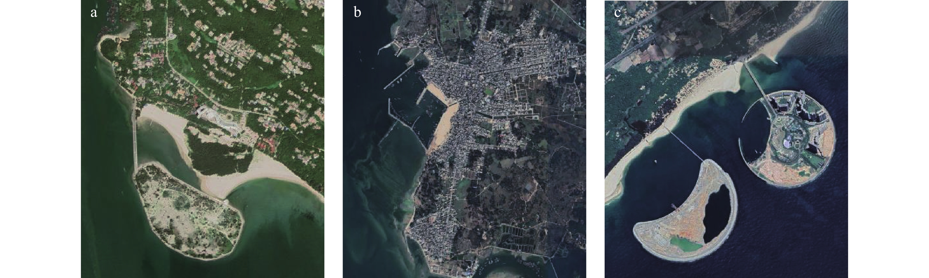
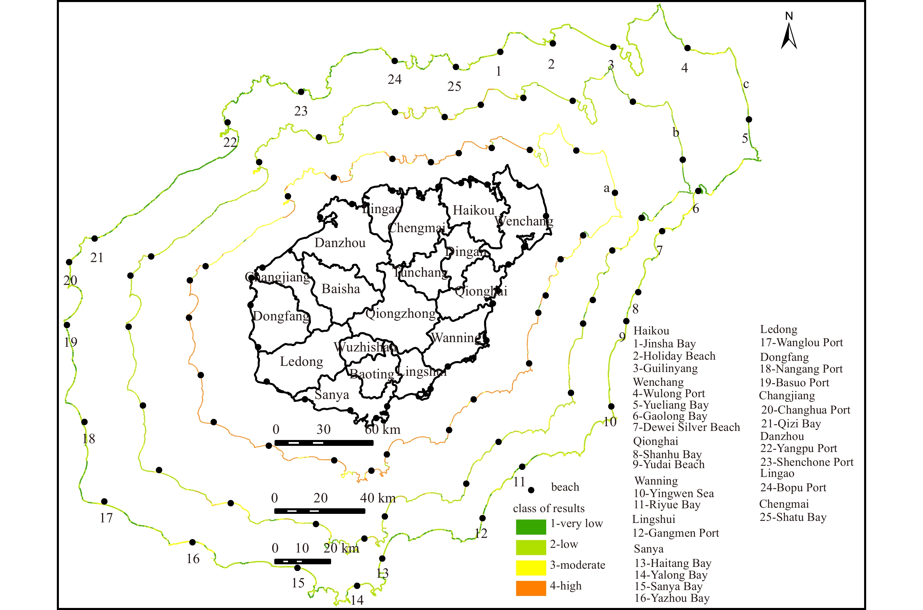
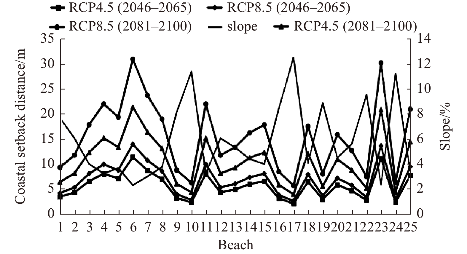
Coastal erosion on islands is increasing due to sea level rise, frequent extreme events, and anthropogenic activities. However, studies on the multifactorial coastal erosion risk and the vulnerability of islands are limited. In this study, the Coastal Erosion Risk Assessment (CERA) method was applied for the first time to the study area in China to assess the erosion risk on the coast of Hainan Island; to explore the effects of coastal ocean dynamics, sediment movement characteristics, and anthropogenic construction; and to discuss the suitability of the method and countermeasures for coastal protection. The results show that the coast of Hainan Island shows high sensitivity, high value, low exposure, and moderate erosion. The whole island showed high vulnerability but low erosion risk, with the eastern region being more affected by erosion, particularly the eastern side of Wulong Port and Yalin Bay in Wenchang, and the shore section of Yalong Bay in Sanya, having a very high risk of coastal erosion. In addition, Monte Carlo simulation was used to check the applicability of the CERA method, and it was found that the rate of shoreline change, population density, and number of storms significantly contributed to coastal erosion, but only the short-term effects of sea level rise were considered. The effects of sea level rise and sediment grain size were primarily analyzed as influencing factors. The effects of sea level rise continue to strengthen, with coastal retreat expected to be greater than 2 m by the mid-21st century. Moreover, Hainan Island is primarily composed of the fine and medium sand types, which have little resistance to coastal erosion. Currently, the impact of sediment grain size is rarely considered in coastal erosion risk assessment studies. However, it can be incorporated into the indicator system in the future, and the spatial variation of indicators can be fully considered to strengthen the refinement study.
Erosion hotspot identified along the sandy coast of Shanwei: characteristics and origin
Jitao Yu, Yuanting Ding, Lin Zhang, Pei Liu, Renfu Fan
2023, 42(7): 91-102. doi: 10.1007/s13131-022-2124-z
Abstract:
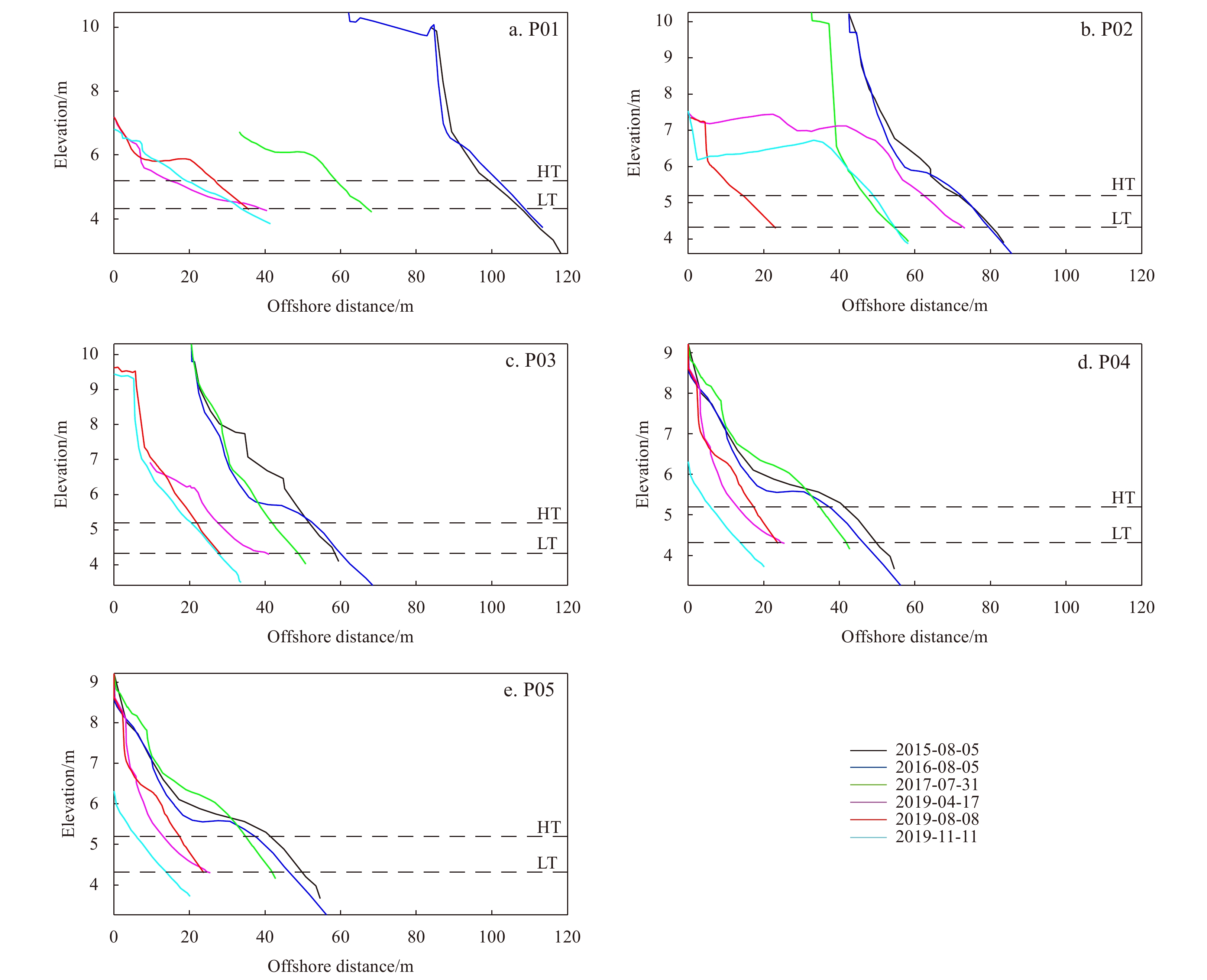
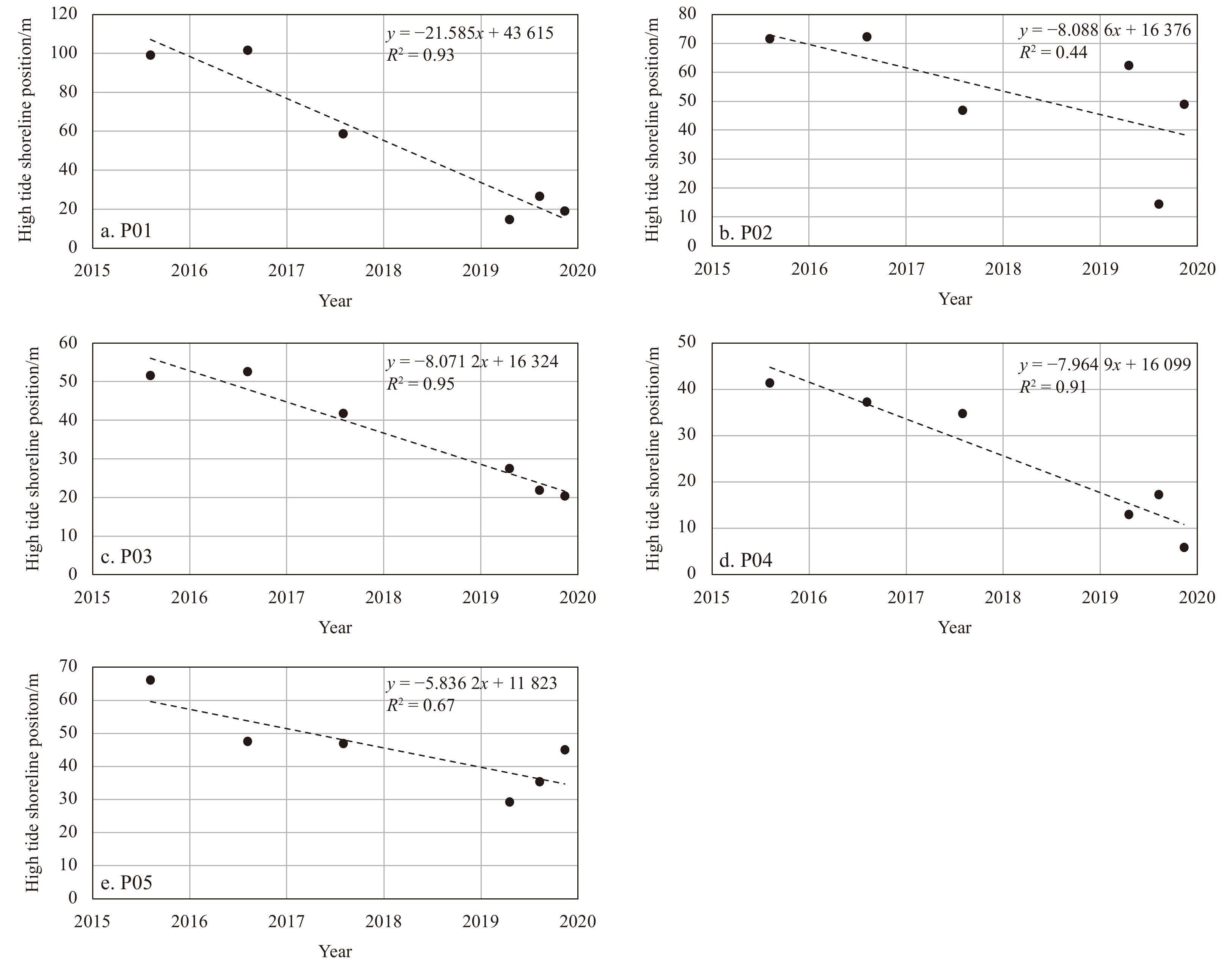
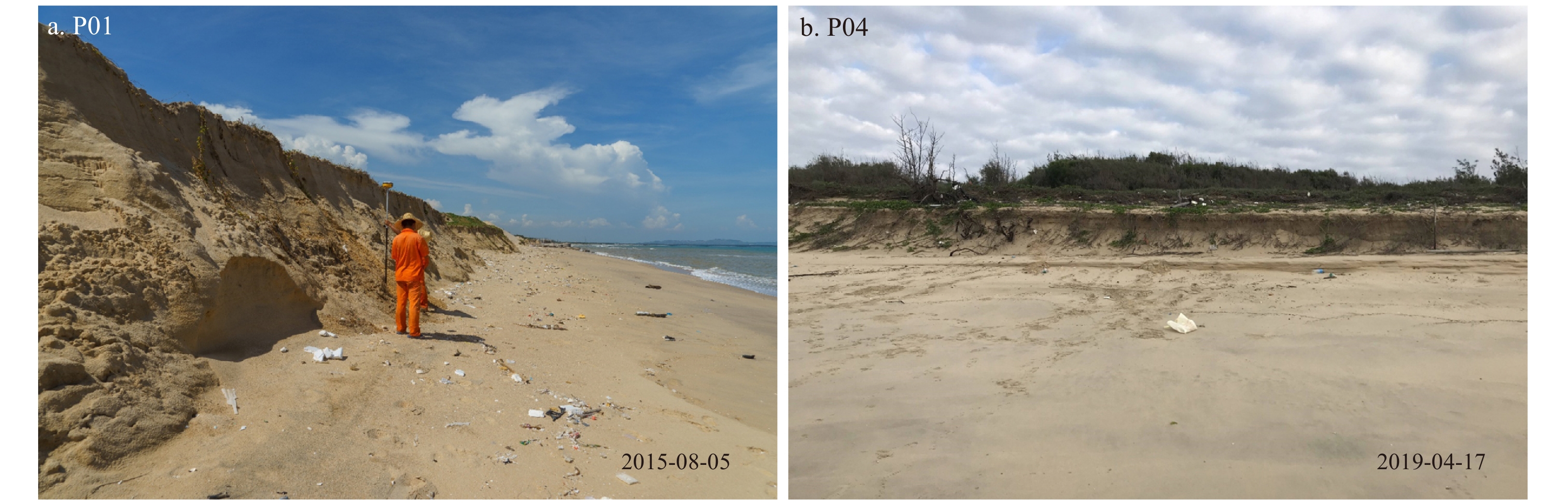
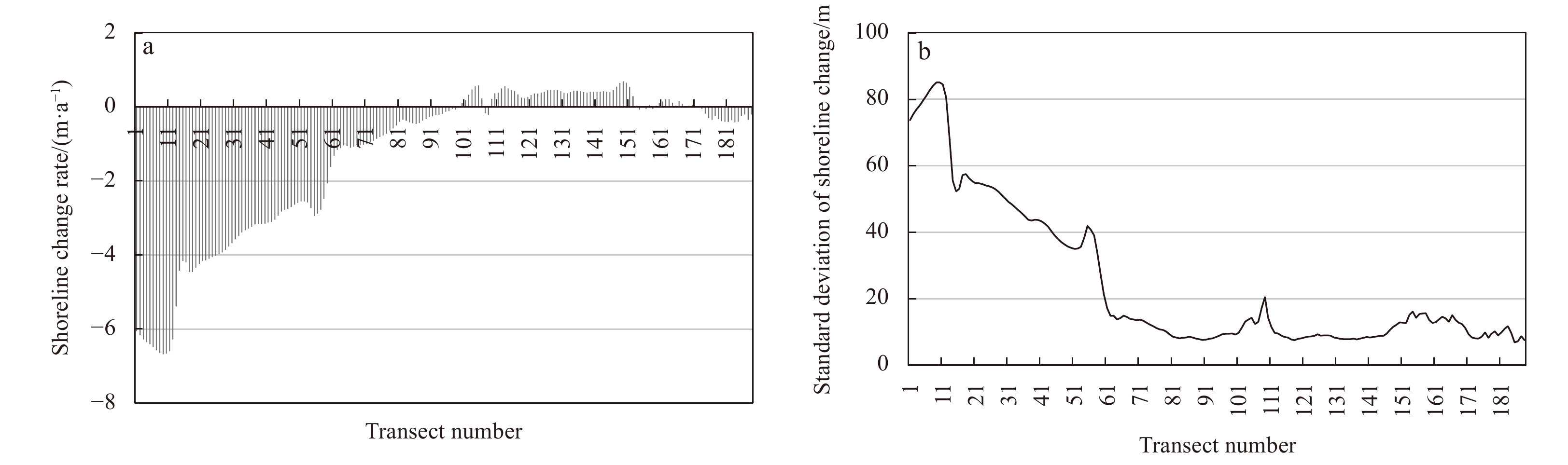
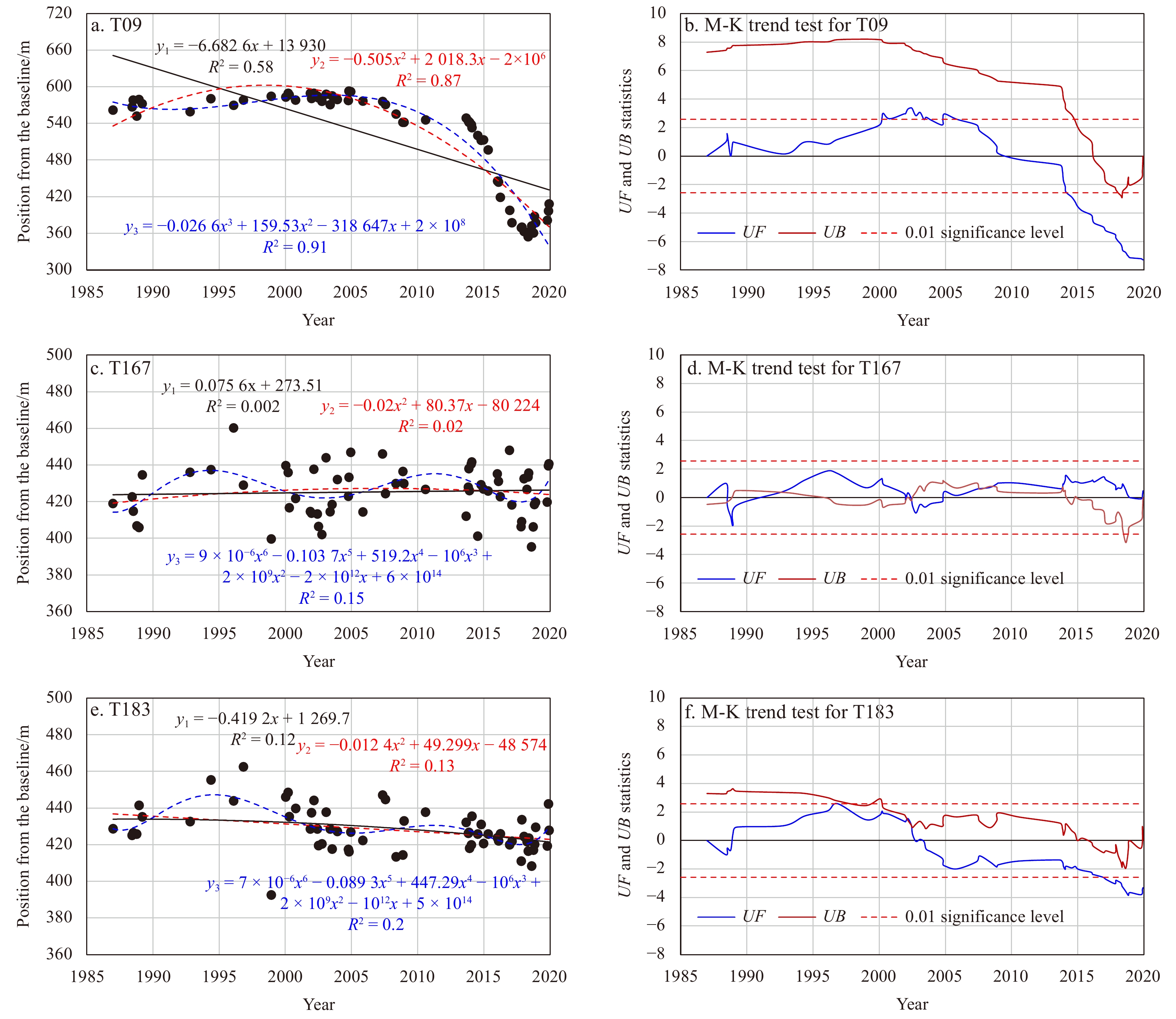
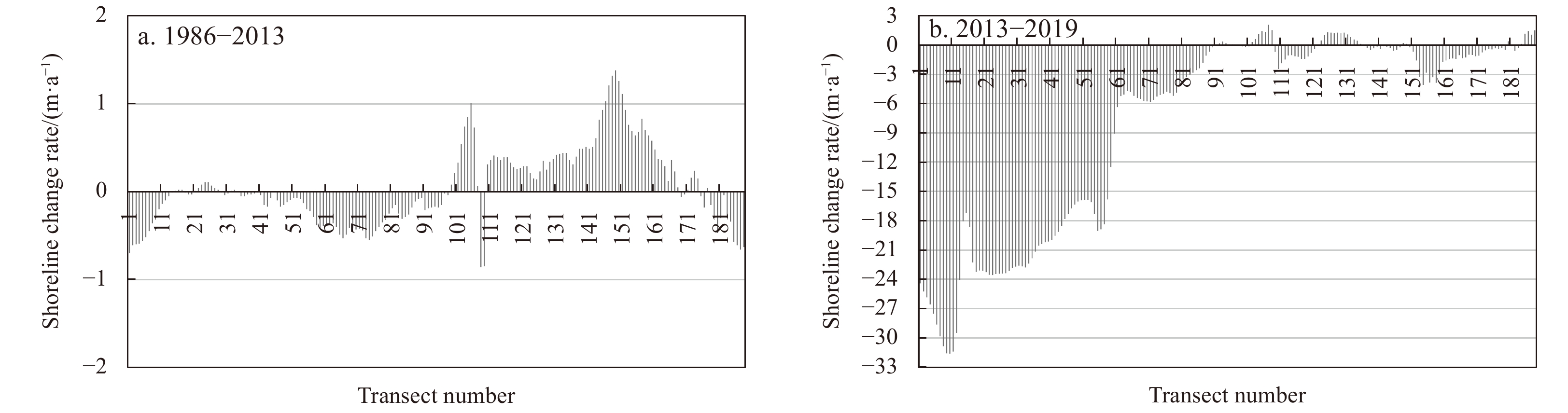
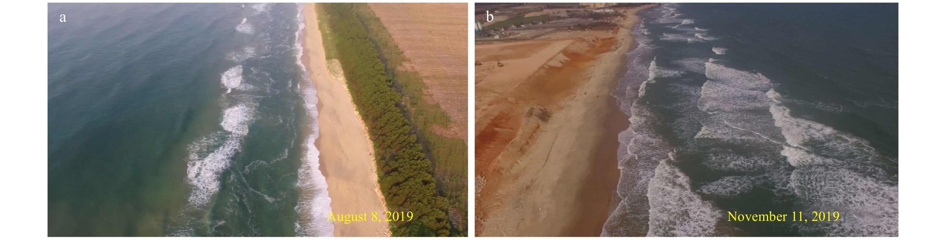
Based on the measured beach profile data of Sanzhou Bay from 2015 to 2019, an erosion hotspot was identified along the Shanwei coastline of eastern Guangdong, where the maximum retreat distance of the shoreline exceeded 80 m and the erosion rate was more than 20 m/a. To determine the time at which the erosion hotspot started and the potential causes of its formation, this study used 63 Landsat satellite images from 1986 to 2019 to construct a time series of shoreline positions over the past 30 years by extracting their high-tide shorelines. Next, the M-K trend test method was introduced to evaluate the non-linear shoreline behavior based on the single-transect method. The results showed that the time of approximately 2013 marked the start of the erosion hotspot, the erosion hotspot was characterized by erosion rates of more than 2 m/a (a maximum rate of 31.6 m/a), and the affected shoreline more than 4.3 km from 2013 to 2019. Furthermore, this erosion hotspot was proved to be caused by artificial sand mining in the nearshore zone, which destroyed the original beach’s morphodynamic equilibrium. With the aid of storm events, soil cliffs composed of loose sediment on the backshore were sacrificed to achieve a new equilibrium, resulting in an extremely significant retreat parallel to the coast on the west side of the study area, which reflects the combined effect of human and natural processes. This study provides a concrete example of the rapid response of shorelines to artificial sand mining activities, and the associated finding is a stark warning about the cautious development and utilization of coastal zones and the strict regulation of human activities.
Dramatical hydro-sedimentary changes induced by bamboo fences over mangrove tidal flat of the largest delta in Beibu Gulf, southwestern China
Zuming Huang, Zhijun Dai, Riming Wang, Xiaoyan Zhou, Wenhong Pang, Jiejun Luo, Bingbin Feng, Baoqing Hu
2023, 42(7): 103-115. doi: 10.1007/s13131-022-2117-y
Abstract:
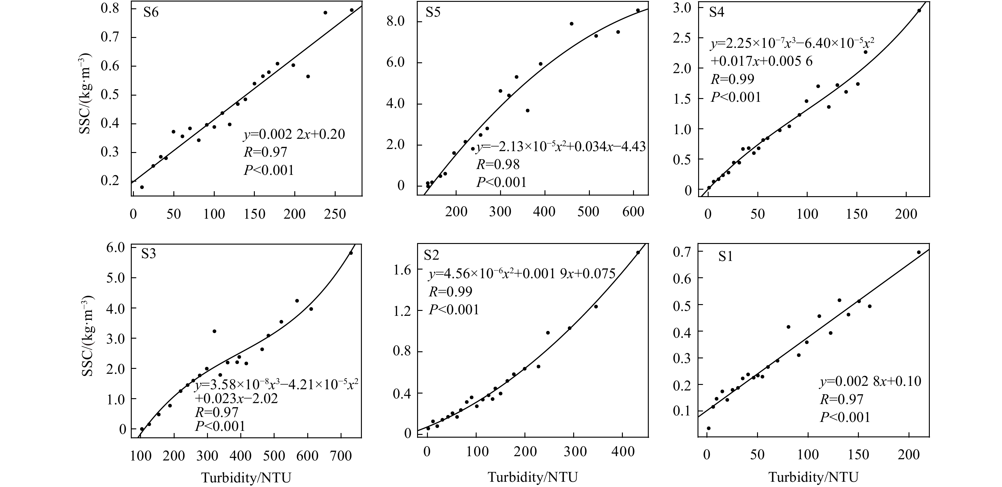
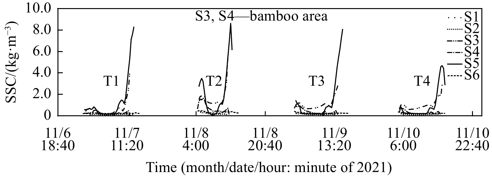
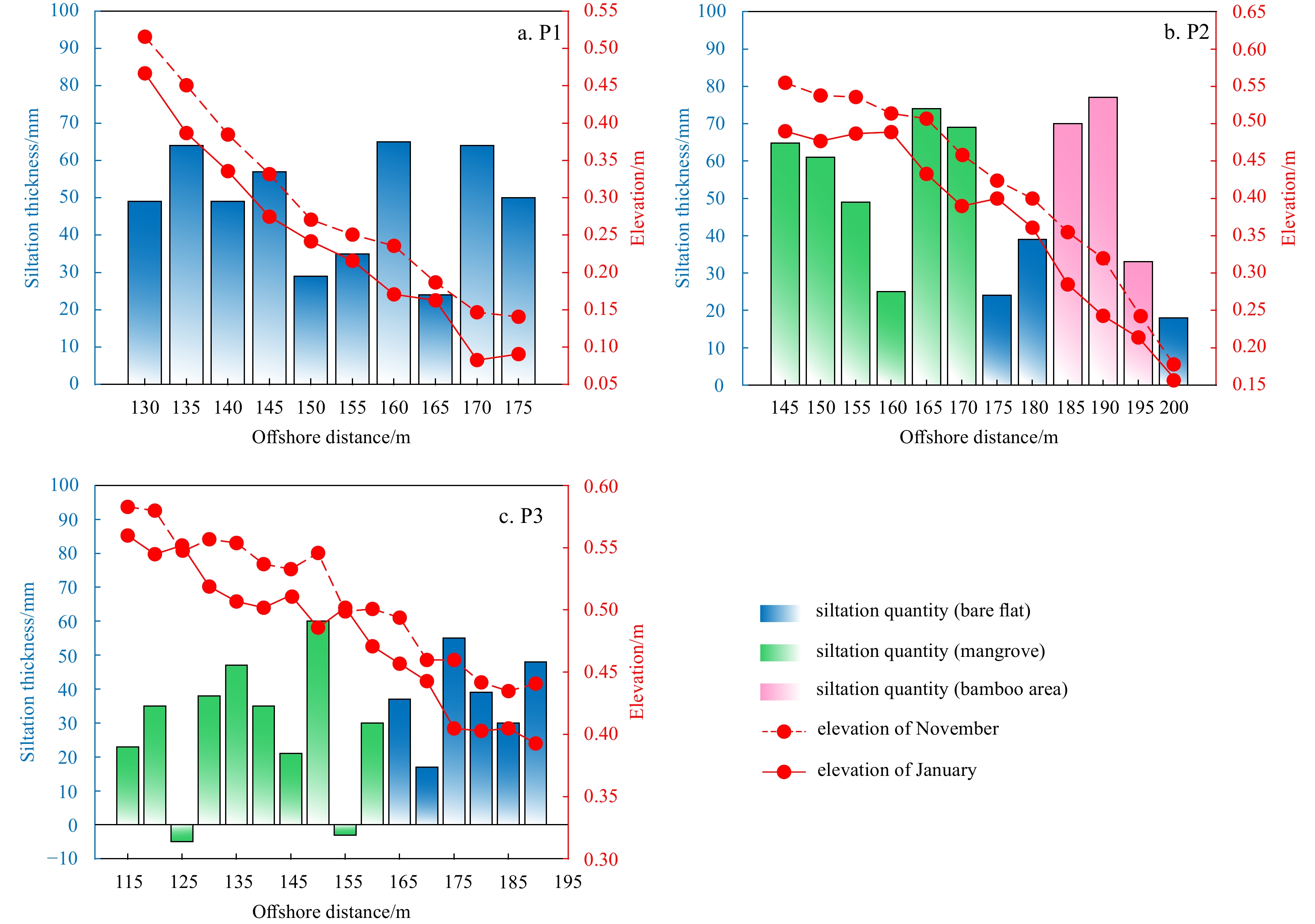
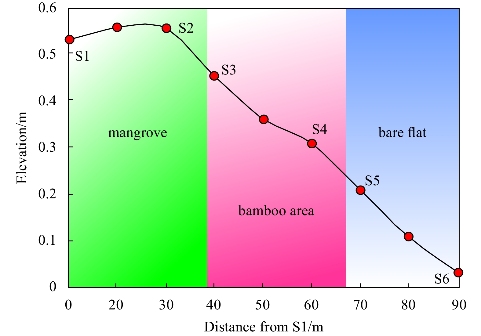
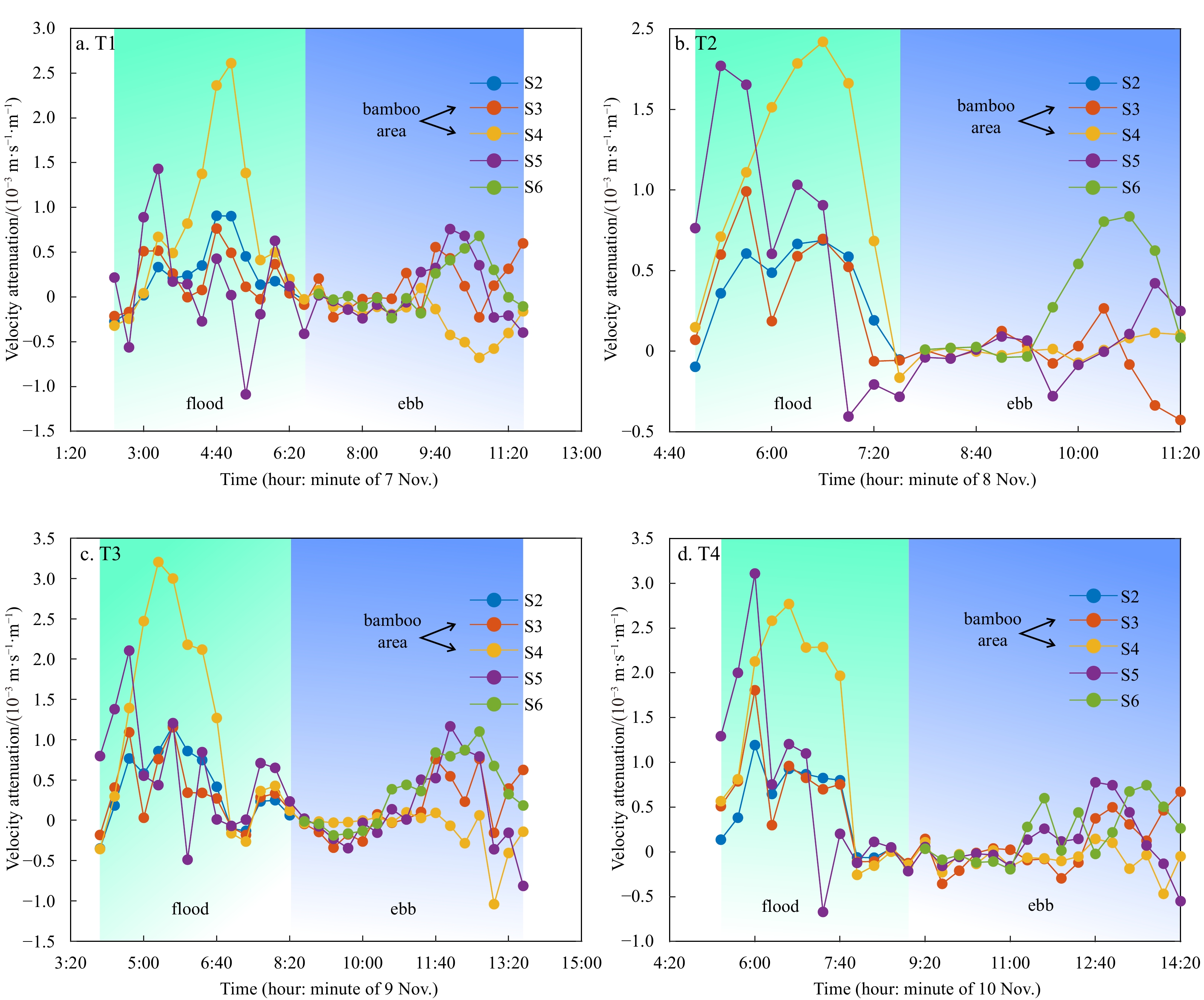
Mangrove forest is one of the most important ecological and environmental resources by effectively promoting tidal flat deposition and preventing the coastal region from typhoon. However, there have been mass loss of mangrove forests due to anthropogenic activities. It is an urgent need to explore an effective way for mangrove restoration. Here, three rows of bamboo fences with hydro-sedimentary observation set over Aegiceras corniculatum mangrove tidal flat of the Nanliu Delta, the largest delta of Beibu Gulf, China, were conducted to analyze the hydro-sedimentary variations induced by bamboo fences. Results identified that the mean horizontal velocity Um per burst (20 min) decreased by as much as 71% and 40% in comparison with those without bamboo fences in March and November, respectively, when the tidal current entering the bamboo area during flood. The maximum of mean horizontal flow velocity Um-max at bamboo area was 50%–75% of that without bamboo fences during ebb tide. The suspended sediment concentration of bamboo area suggested a maximum reduction of 57% relative to bare flat during flood, and was 80% lower than bare flat at ebb peak. Moreover, the turbulent kinetic dissipation ε at flood tide was significantly higher than that at ebb tide, while the bamboo fences greatly increased the turbulent kinetic dissipation ε by 2 to 5 times relative to bare flat, resulting in an increase of the bed elevation by inhibiting the sediment incipient motion and intercepting suspended sediment. The siltation rate at the bamboo area was 140% and 29.3% higher than that at the bare flat and the region covered with A. corniculatum, respectively. These results highlight that bamboo fences can effectively attenuate tidal current and thus promote siltation over mangrove flat, which contribute great benefit to mangrove survival.
Dramatic changes in the horizontal structure of mangrove forests in the largest delta of the northern Beibu Gulf, China
Riming Wang, Zhijun Dai, Hu Huang, Xixing Liang, Xiaoyan Zhou, Zhenming Ge, Baoqing Hu
2023, 42(7): 116-123. doi: 10.1007/s13131-022-2126-x
Abstract:
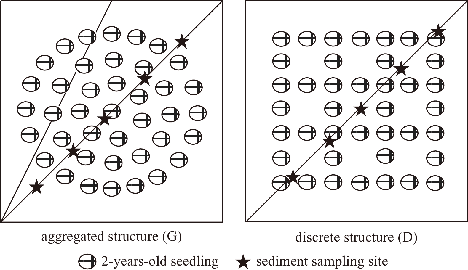
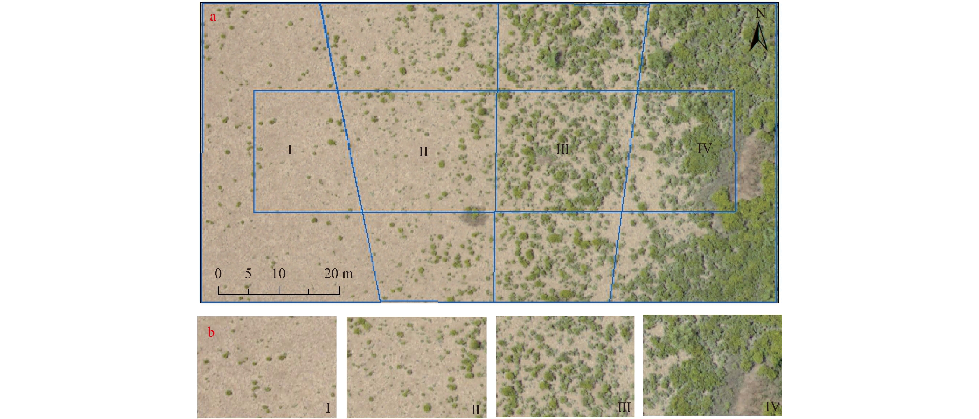
The horizontal structure of mangrove forests is an important characteristic that reflects a significant signal for coupling between mangroves and external drivers. While the loss and gain of mangroves has received much attention, little information about how the horizontal structure of mangrove forests develops from the seedling stage to maturity has been presented. Here, remote sensing images taken over approximately 15 years, UVA images, nutrient elements, sediments, and Aegiceras corniculatum vegetation parameters of the ecological quadrats along the Nanliu Delta, the largest delta of the northern Beibu Gulf in China, are analyzed to reveal changes in the horizontal structure of mangroves and their associated driving factors. The results show that both discrete structures and agglomerated structures can often be found in A. corniculatum seedlings and saplings. However, the combination of seedlings growing into maturity and new seedlings filling in available gaps causes the discrete structure of A. corniculatum to gradually vanish and the agglomerate structure to become stable. The aggregated structure of seedlings, compared to the discrete structure, can enhance the elevation beneath mangroves by trapping significantly more sediments, providing available spaces and conditions for seedlings to continue growing. Furthermore, by catching fine sediments with enriched nutrients, the survival rate of A. corniculatum seedlings in the agglomerated structure can be much higher than that in the discrete structure. Our results highlight the significance of the agglomeration of A. corniculatum, which can be beneficial to coastal mangrove restoration and management.
Experimental study on the mitigation effect of mangroves during tsunami wave propagation
Cheng Chen, Chen Peng, Hui Yan, Minjian Wei, Tingyu Wang
2023, 42(7): 124-137. doi: 10.1007/s13131-023-2161-2
Abstract:
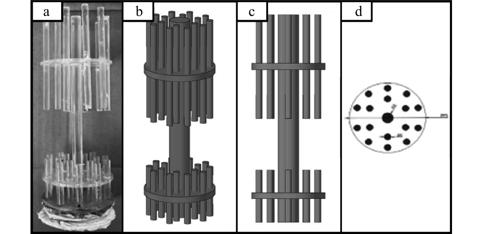
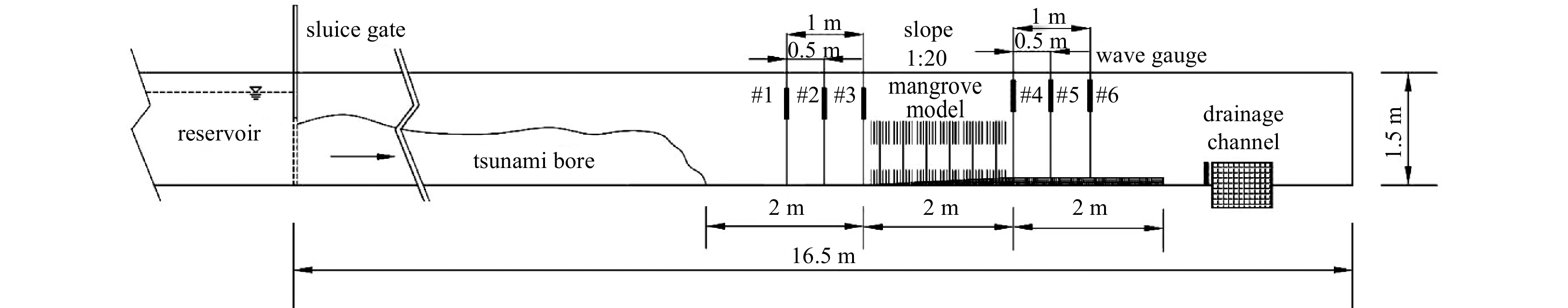
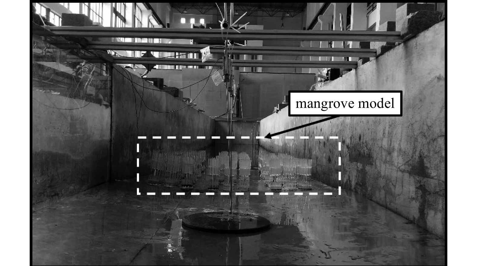
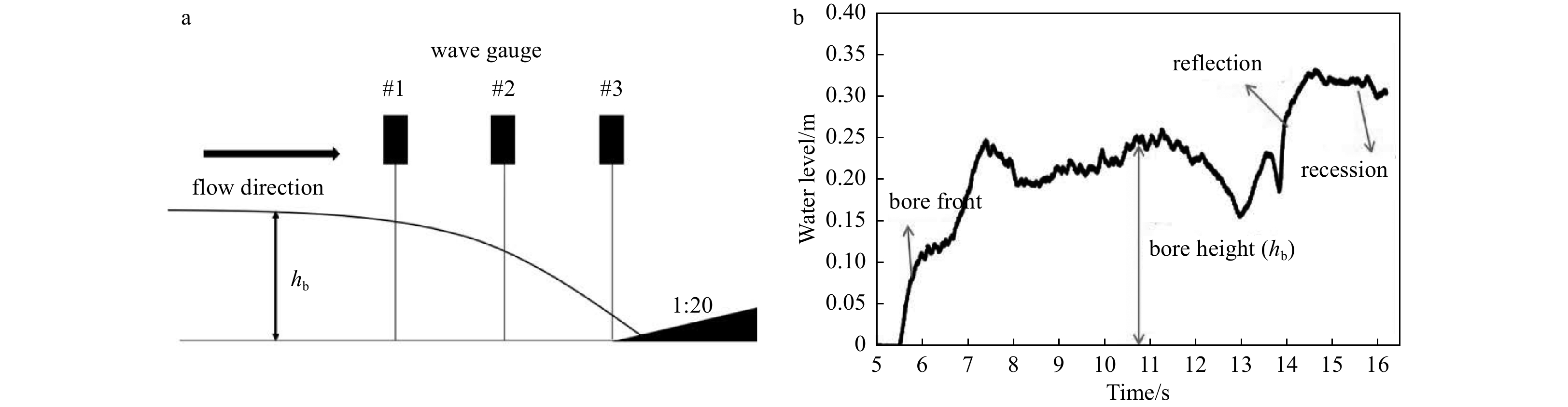
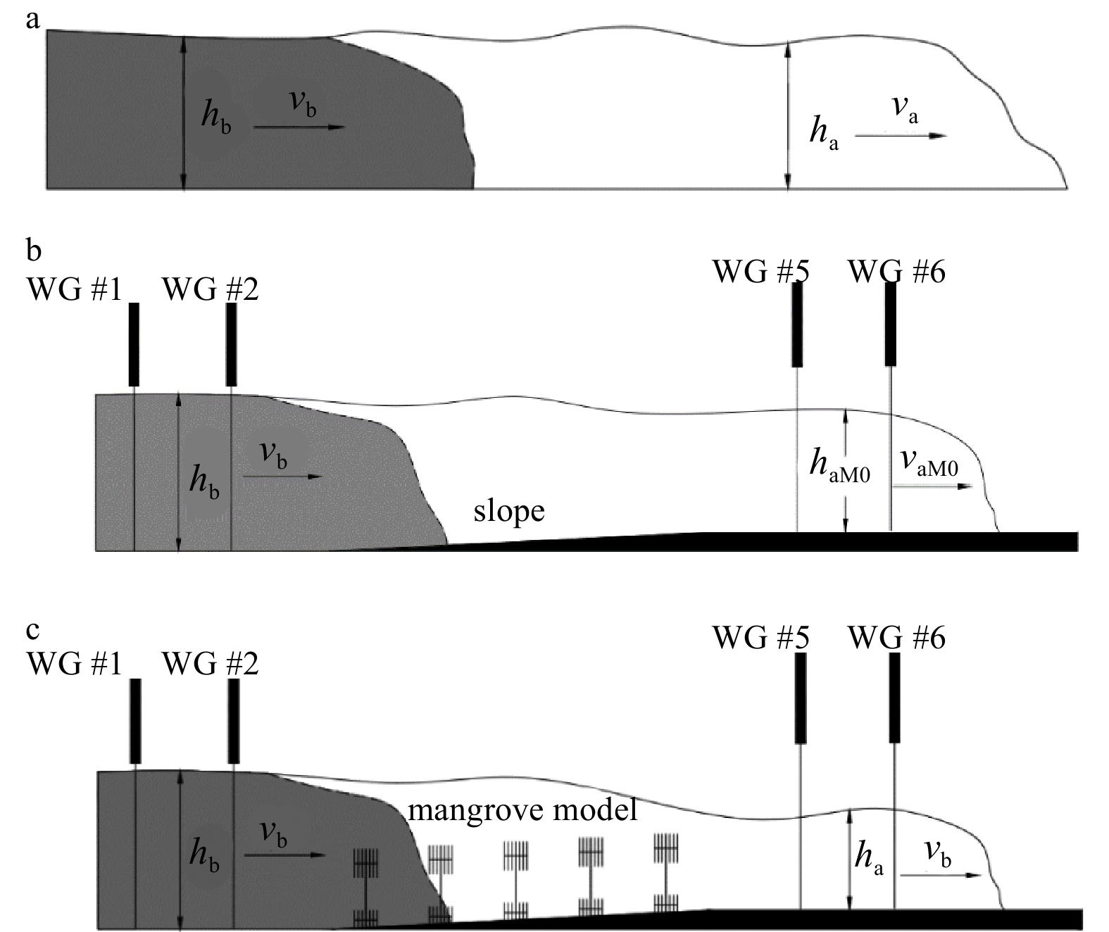
Mangroves are crucial for protecting coastal areas against extreme disasters such as tsunamis and storm surges. An experimental study was conducted to determine how mangroves can mitigate the tsunami wave propagation. The test was performed in a flume, where mangrove models were installed on a slope, and dam-burst waves were used to simulate tsunami waves. To study how mangrove forests reduce the impact of tsunamis, this paper measured the heights of the incoming waves under different initial conditions (tsunami wave intensity and initial water depth) and plant factors (arrangement and distribution density) and described the reduction process. The results show that, after passing through the mangrove, the tsunami bore height will decrease within a certain range as the initial water depth increases. However, there is no correlation between the increase of inundation level and the drop of water level. The bore height attenuation is more significant at higher density of mangroves, but after tsunami passing through the mangroves, the relative bore height will decrease. When the distribution density of mangroves is constant, the wave attenuation at different locations (before, on and after the slope) shows different relationships with the initial water depth and wave height for different models. The transmission coefficient (\begin{document}$ {K }_{i} $\end{document}) shows a parabolic correlation with its density. The proportion of the energy loss caused by the mangrove resistance to the total energy (\begin{document}$ {E }_{b} $\end{document}) is defined as \begin{document}$ {C}_{m2} $\end{document}. The variation trend of \begin{document}$ {C}_{m2} $\end{document} corresponds to the tsunami wave energy attenuation rate (\begin{document}$ {C}_{a} $\end{document}) and \begin{document}$ {K }_{i} $\end{document}.
Nourishment and disaster mitigation efficiency of feeding sand on the dry section of a dissipative beach
Yazhuang Zhao, Hongshuai Qi, Shaohua Zhao, Feng Cai, Jianhui Liu, Pu Xu, Zheyu Xiao, Yanyu He, Zhiyong Zhang
2023, 42(7): 138-148. doi: 10.1007/s13131-023-2193-7
Abstract:
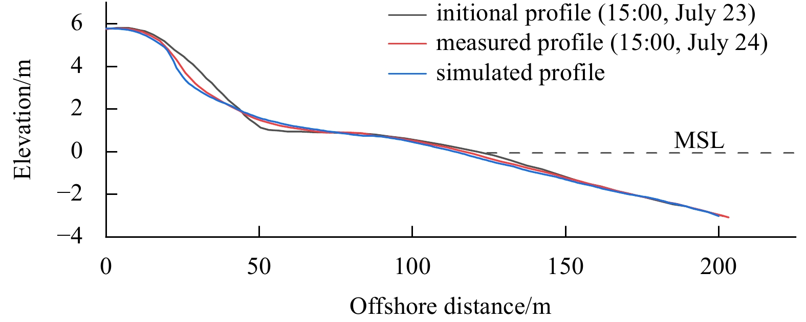
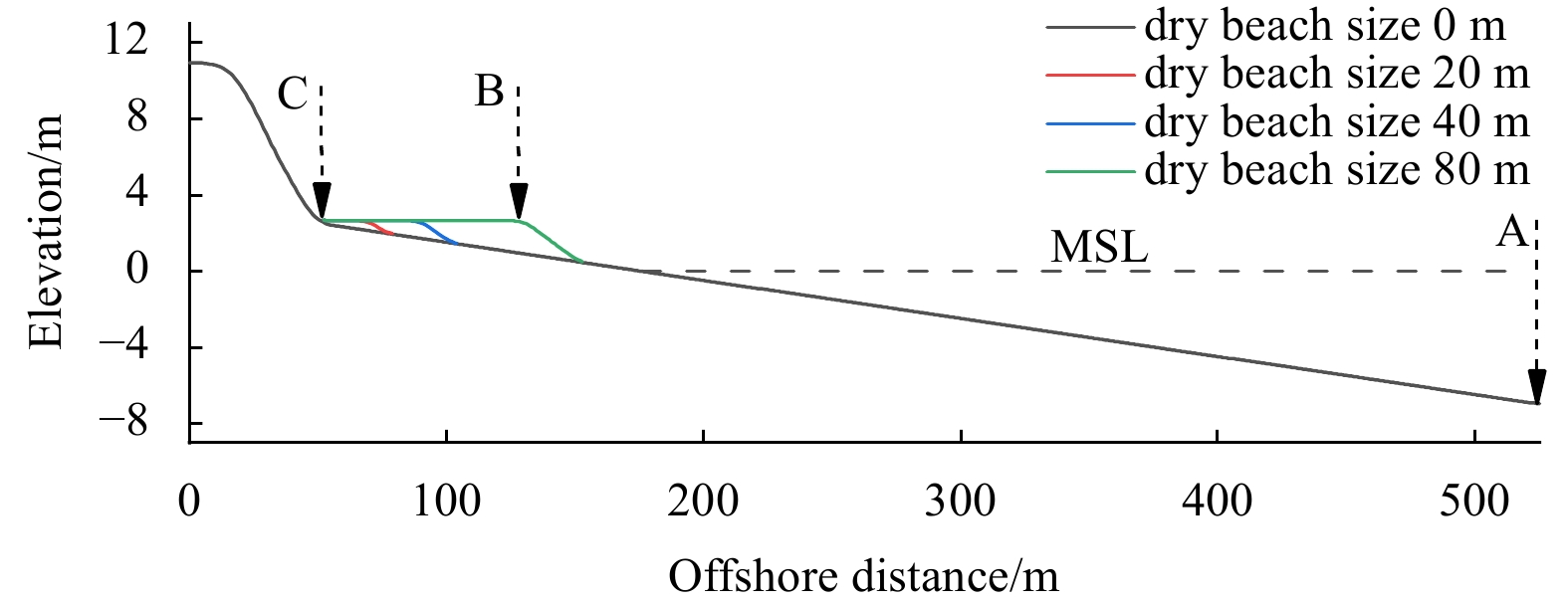
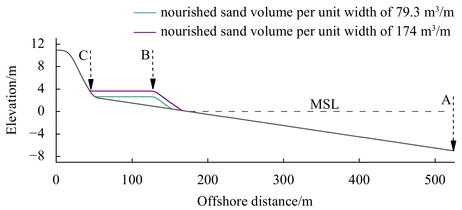
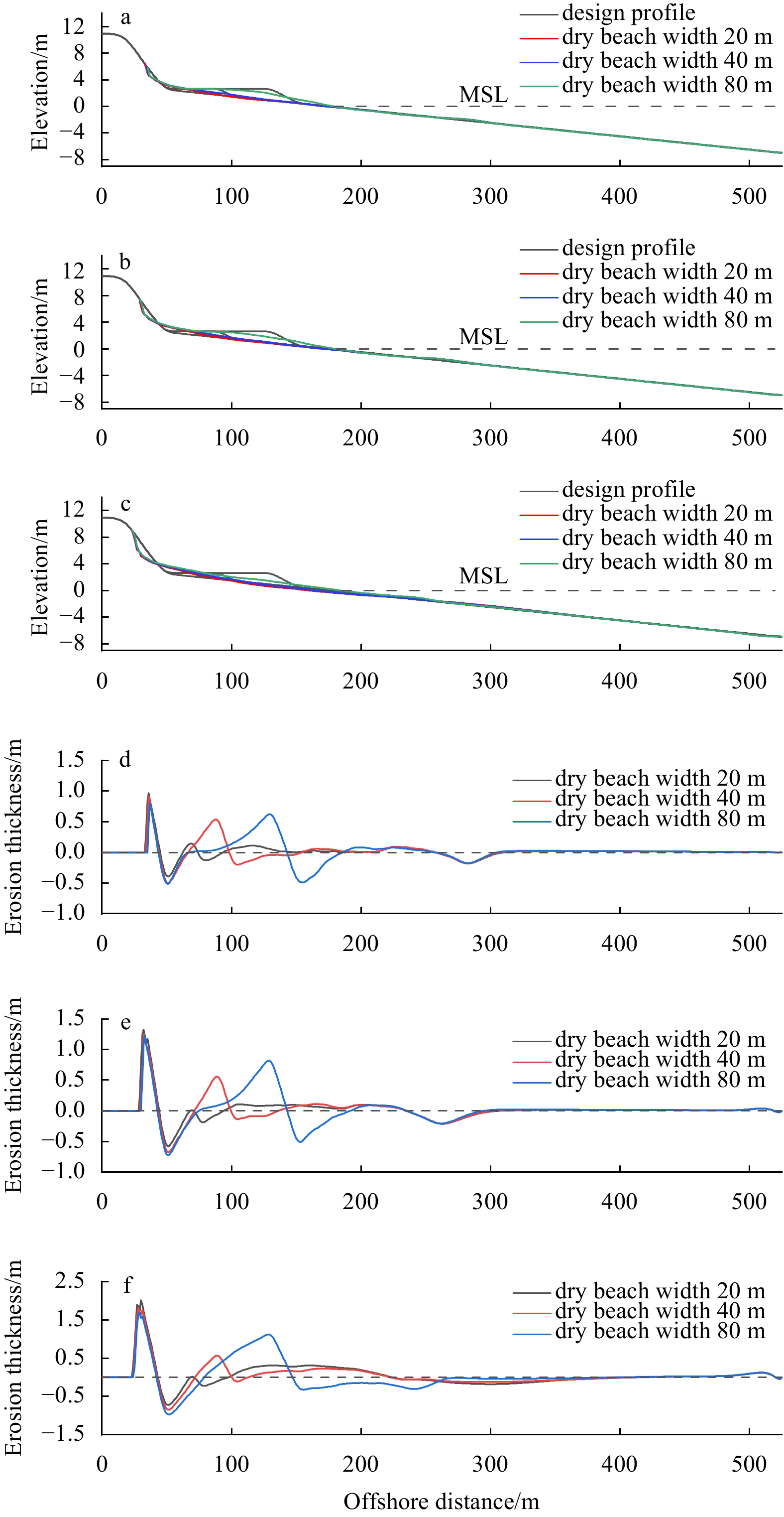
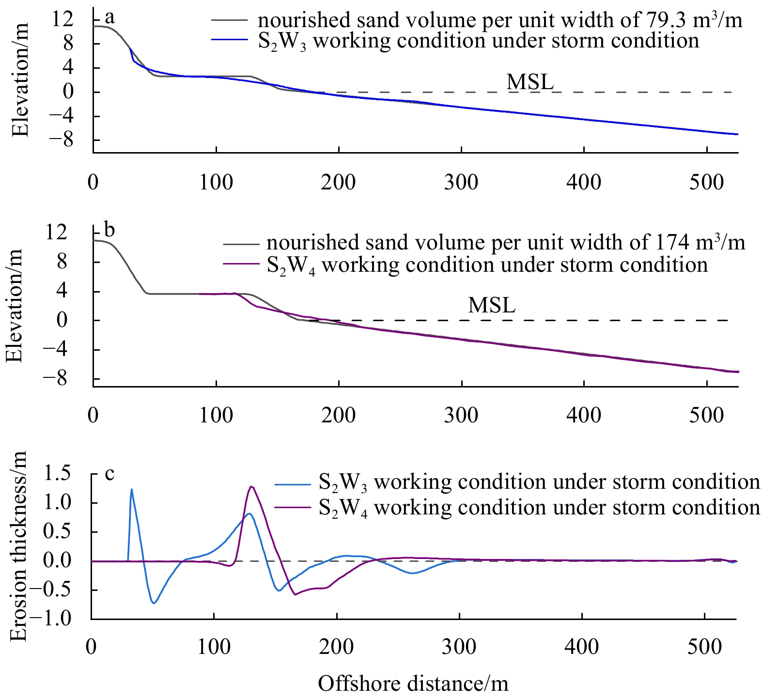
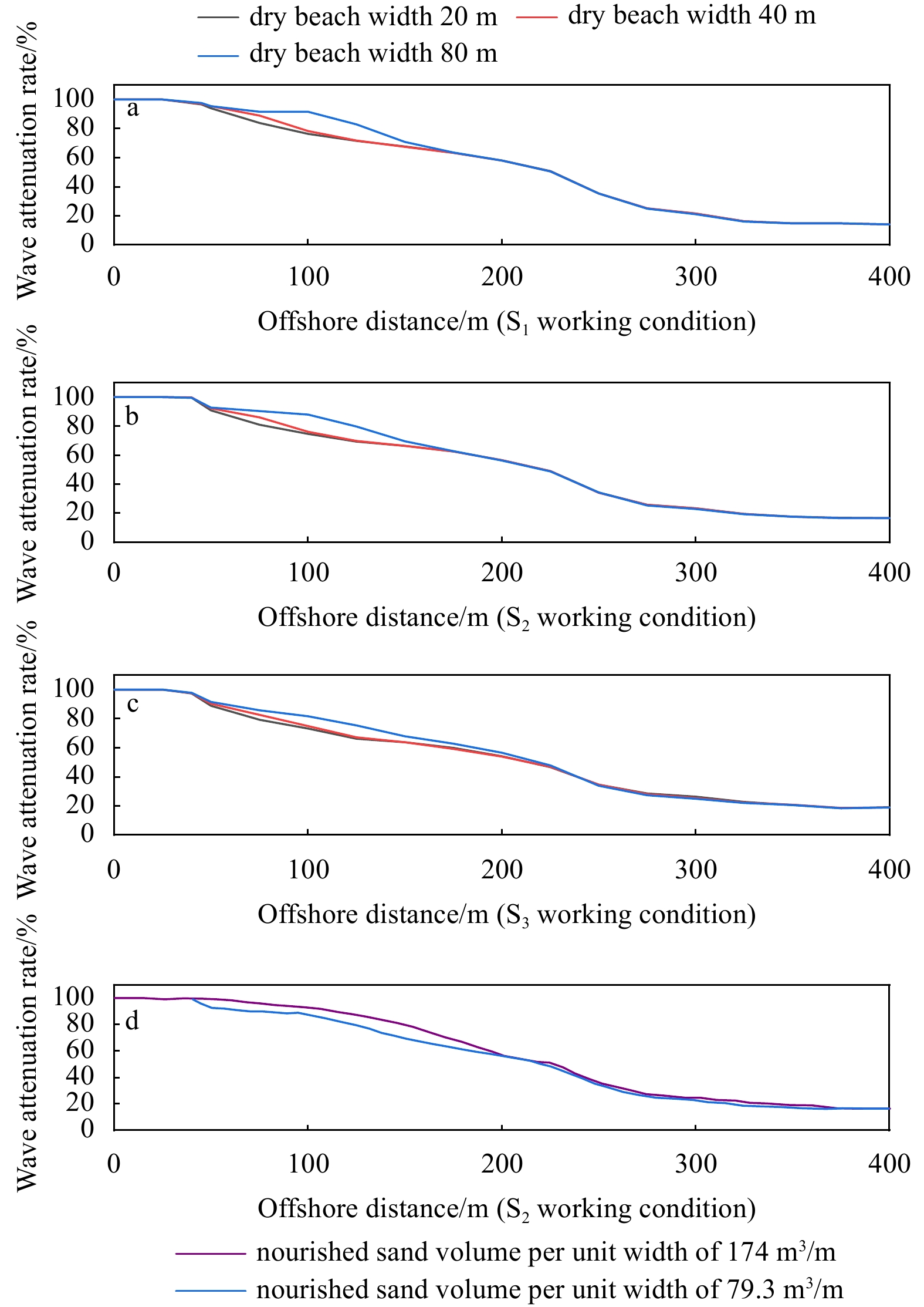
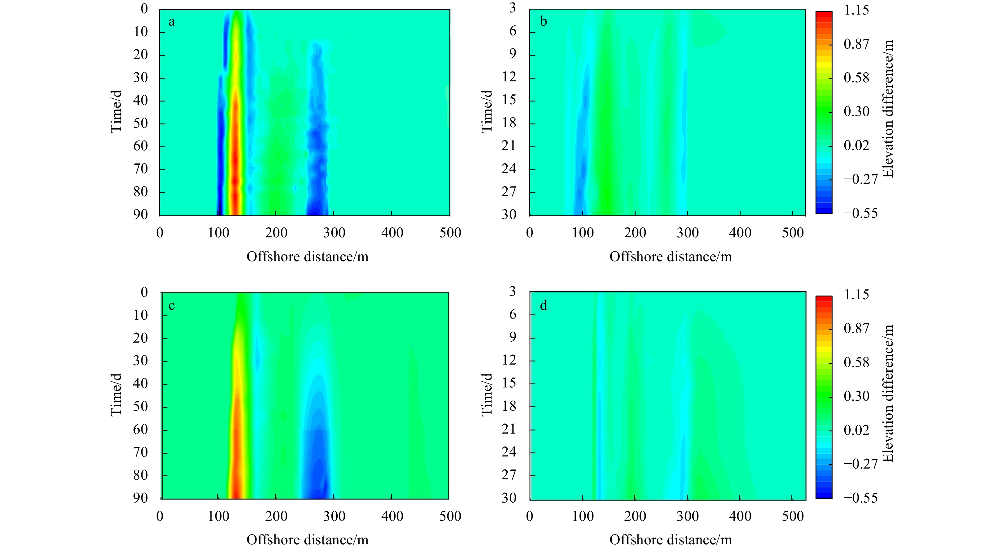
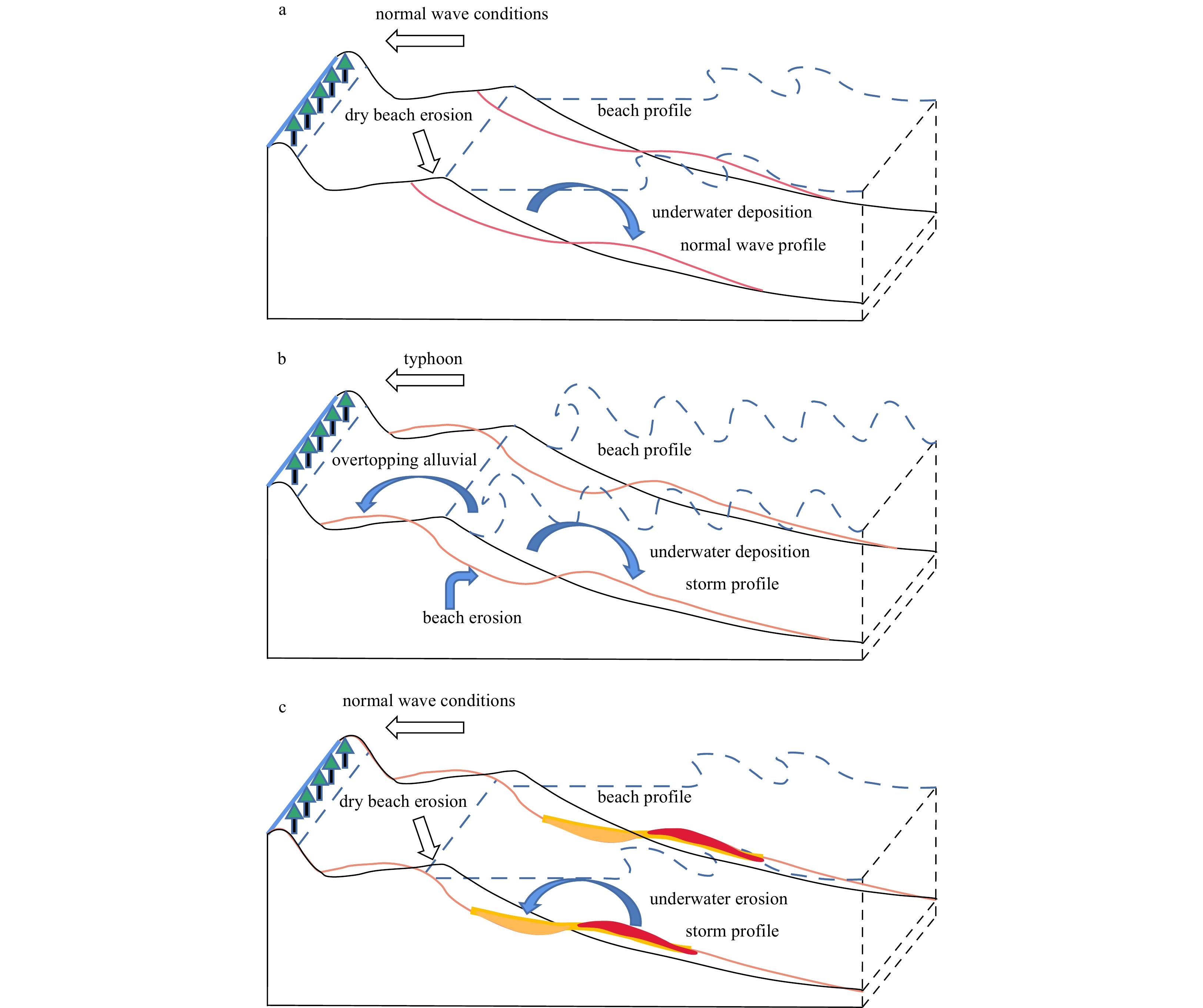
To explore the nourishment effect and disaster reduction efficiency of a fully dissipative dry beach under the impact of storms, this paper uses the measured topography and hydrodynamic data to establish a one-dimensional numerical model of the XBeach beach profile. By numerically modeling the change in the nourished profile for different dry beach widths under normal waves and storm conditions and the recovery process of the profile after the storm, the degree of response in dry beach nourishment for the fully dissipative beach is analyzed. The results show that under normal wave conditions, the response of the nourished dry beach is obvious. Sediment on the dry beach erodes heavily, and the shoreline moves landward over a long distance. With the increase in the width and size of the dry beach, the wave height at the bottom of the backshore profile decreases, the wave height attenuation rate increases continuously, and the wave elimination effect is remarkable. When the storm incident wave intensifies, the wave height attenuation rate of the nourished dry beach decreases, indicating that the smaller the storm intensity is, the more significant the wave reduction effect of the nourished dry beach is. At the same time, different profile arrangements of nourished dry beaches suffer from different degrees of erosion under storm conditions, with significant changes in profile morphology. With intensified storm action, the intensity of sediment erosion in the nourished dry beach increases, the nourishment is weakened, and the recovery effect of the profile after the storm is not obvious. The results of the numerical modeling highlight that the dry beach nourishment method can resist storms to a certain extent, but the overall effect is relatively limited.
Variation in cross-shore wind speeds influenced by the morphology of nourished beach
Xu Chen, Jianhui Liu, Feng Cai, Yanyu He, Bailiang Li, Hongshuai Qi, Shaohua Zhao, Gen Liu
2023, 42(7): 149-159. doi: 10.1007/s13131-023-2224-4
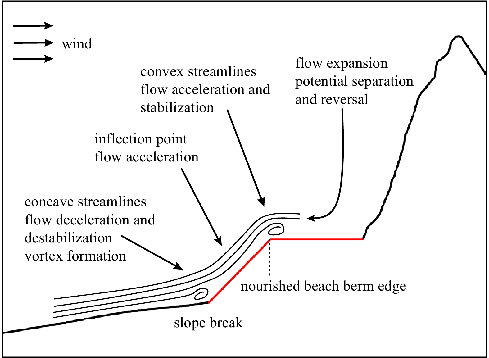
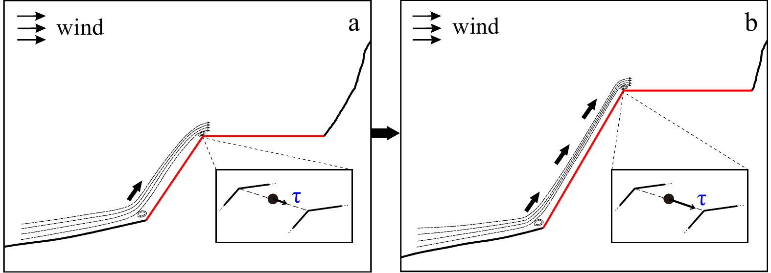
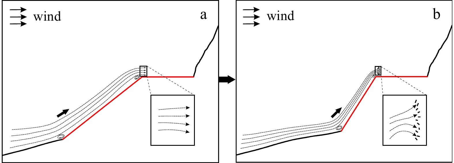
Abstract:
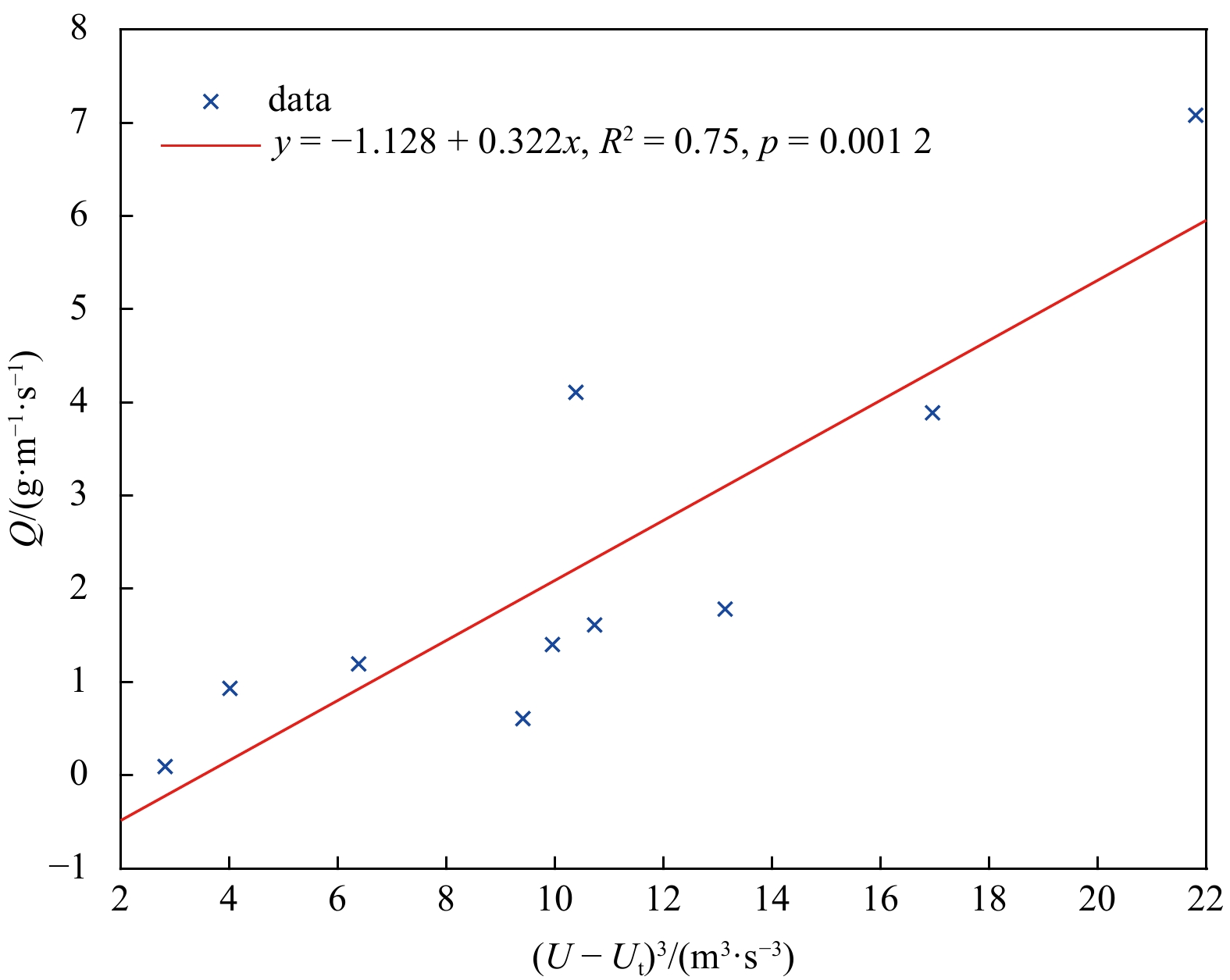
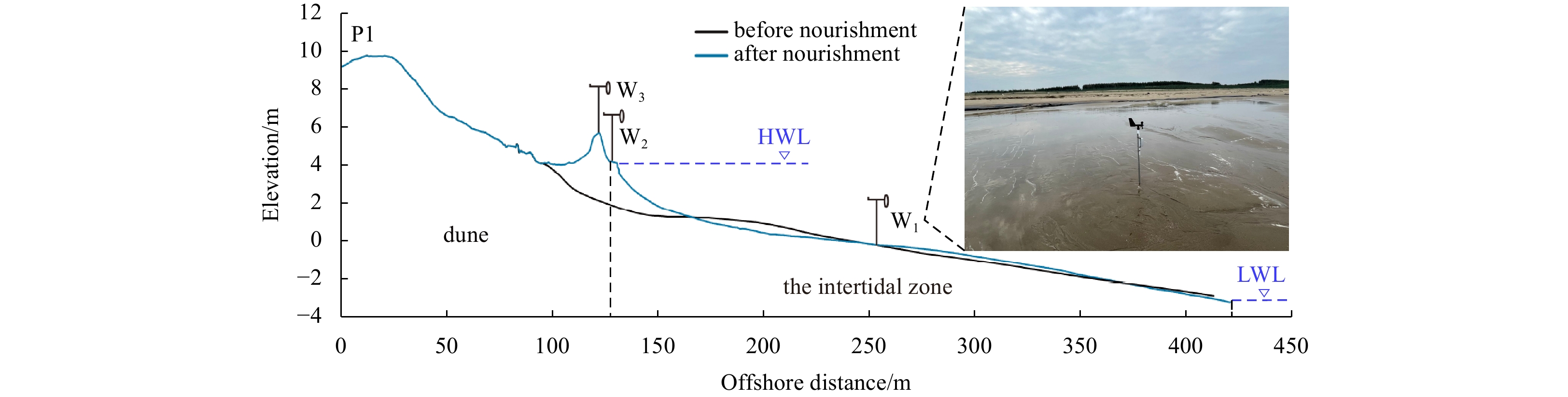
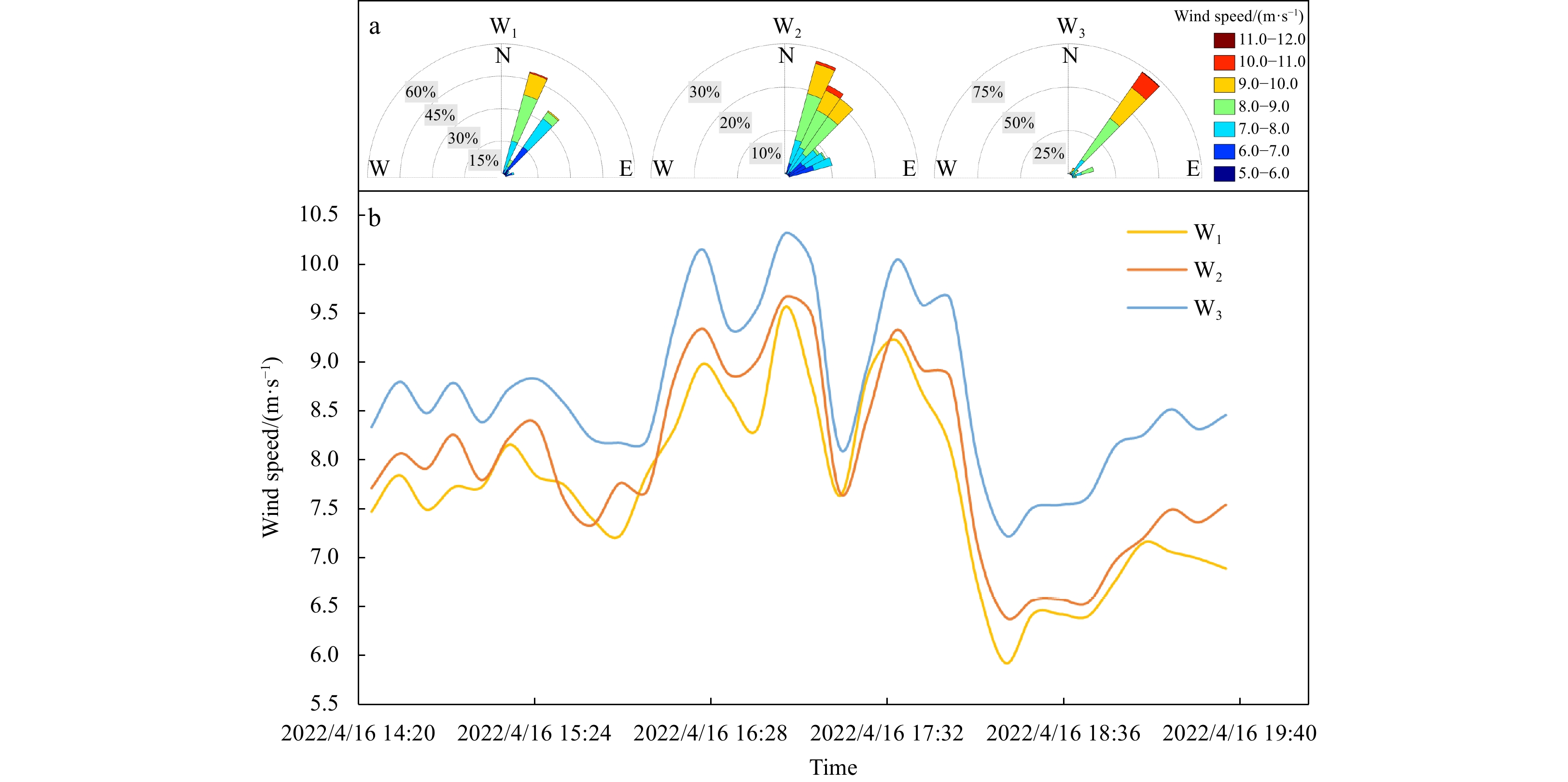
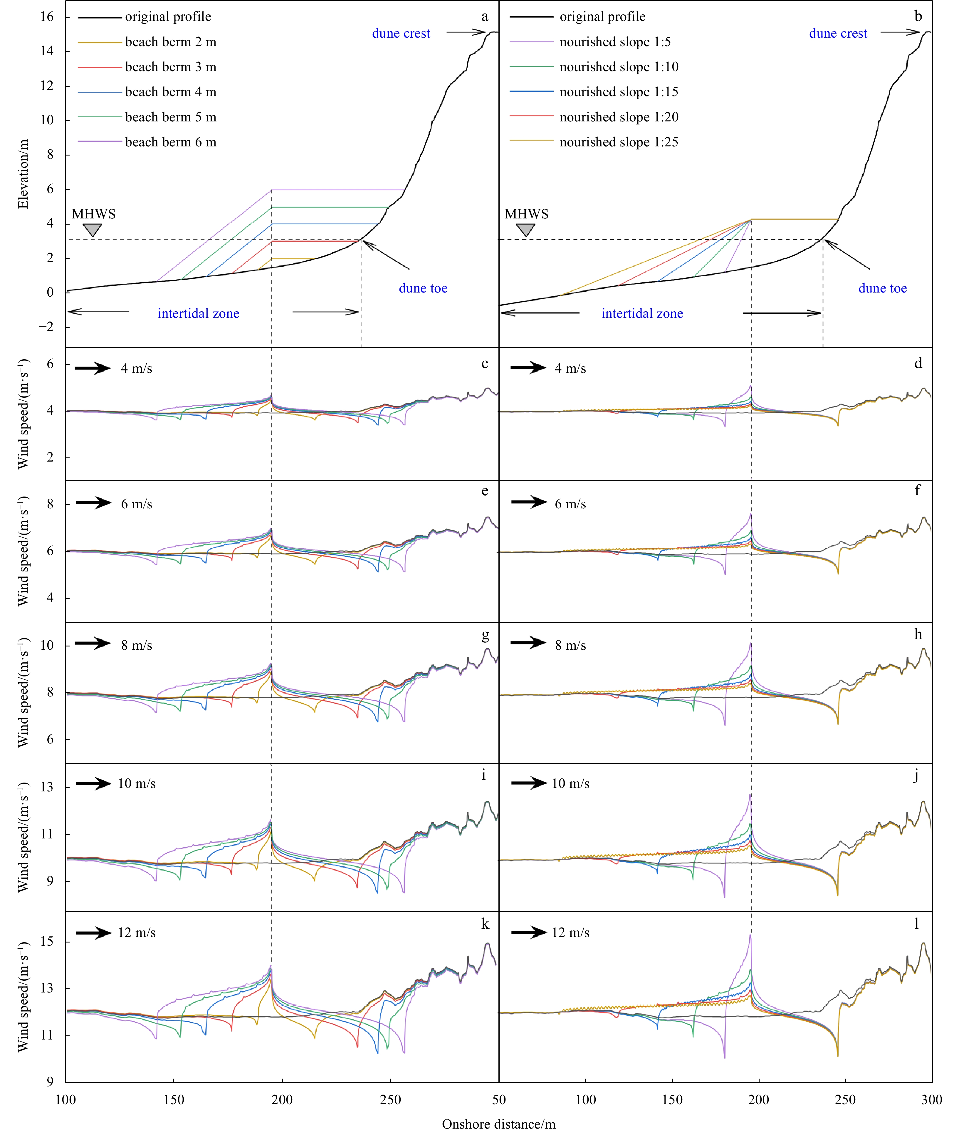
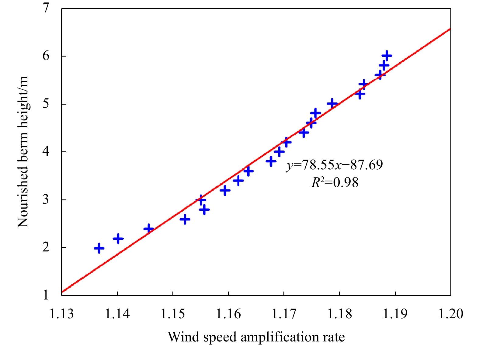
The cross-shore variation in wind speeds influenced by beach nourishment, especially the dramatic changes at the nourished berm, is important for understanding the aeolian sand transport processes that occur after beach nourishment, which will contribute to better beach nourishment project design on windy coasts. In this paper, the influencing factors and potential mechanism of wind speed variation at the edge of a nourished berm were studied. Field observations, together with the Duna model, were used to study the cross-shore wind speed distribution for different nourishment schemes. The results show that the nourished berm elevation and beachface slope are the main factors controlling the increase in wind speed at the berm edge. When the upper beach slope is constant, the wind speed at the berm edge has a positive linear correlation with the berm elevation. When the berm elevation remains constant, the wind speed at the berm edge is also proportional to the upper beach slope. Considering the coupling effects of nourished berm elevation and beachface slope, a model for predicting the wind speed amplification rate at the nourished berm edge was established, and the underlying coupling mechanism was illustrated.
Vulnerability assessment of coastal wetlands in Minjiang River Estuary based on cloud model under sea level rise
Xiaohe Lai, Chuqing Zeng, Yan Su, Shaoxiang Huang, Jianping Jia, Cheng Chen, Jun Jiang
2023, 42(7): 160-174. doi: 10.1007/s13131-023-2169-7
Abstract:
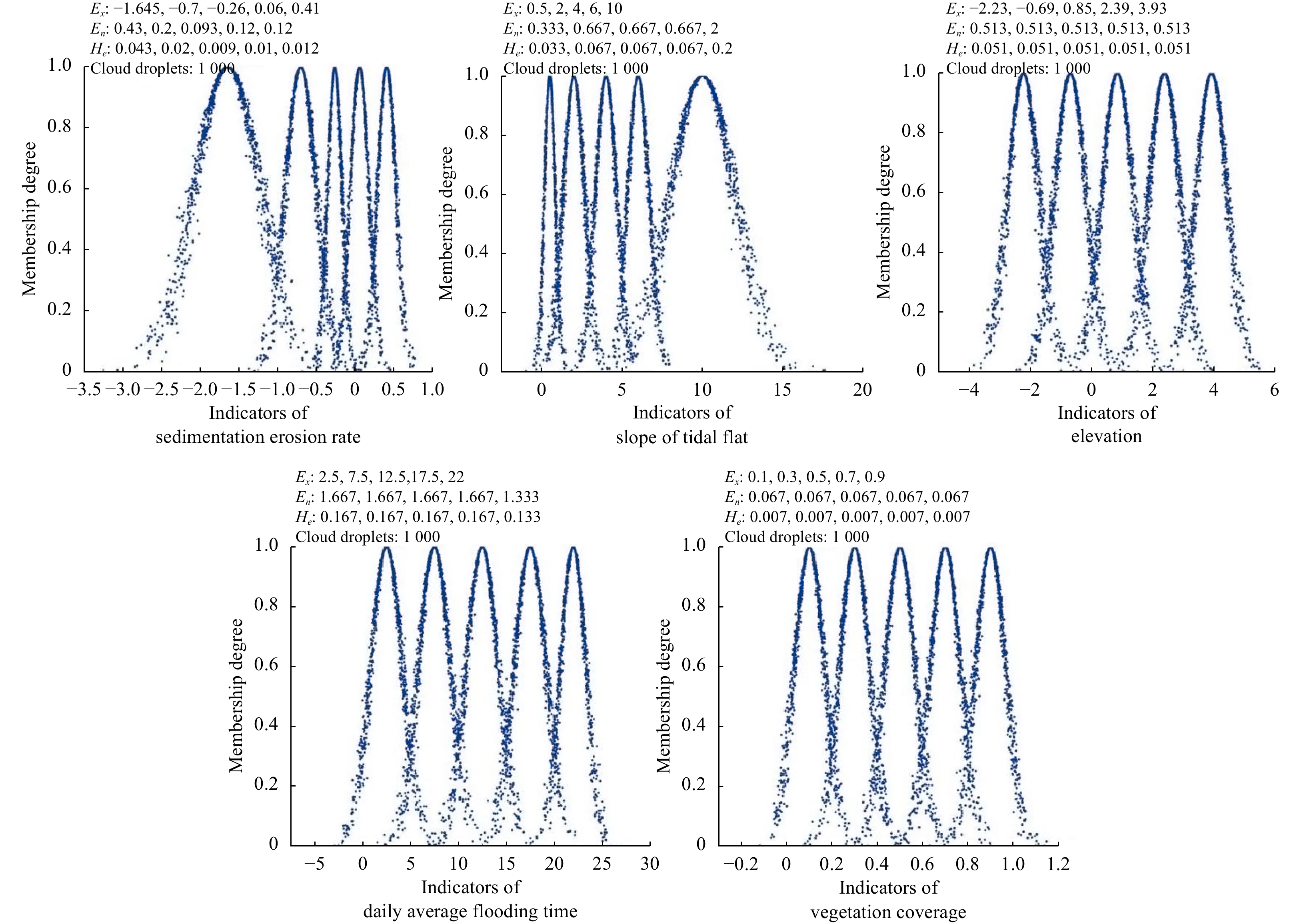
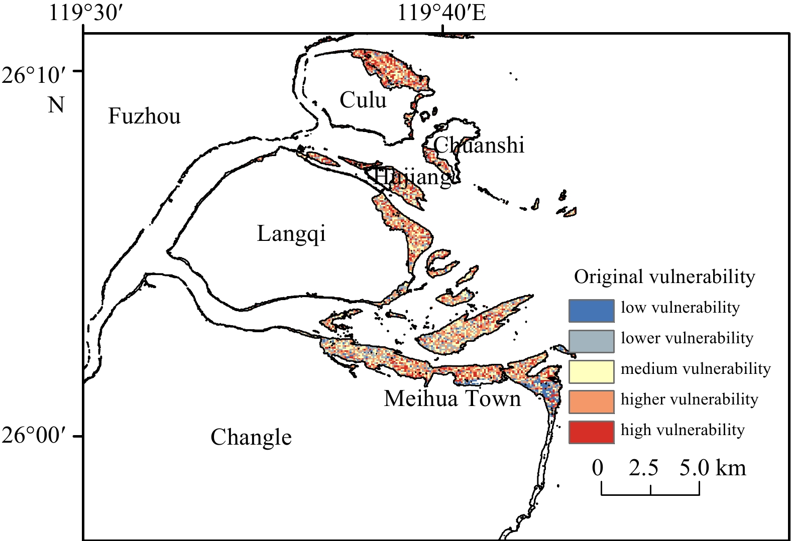
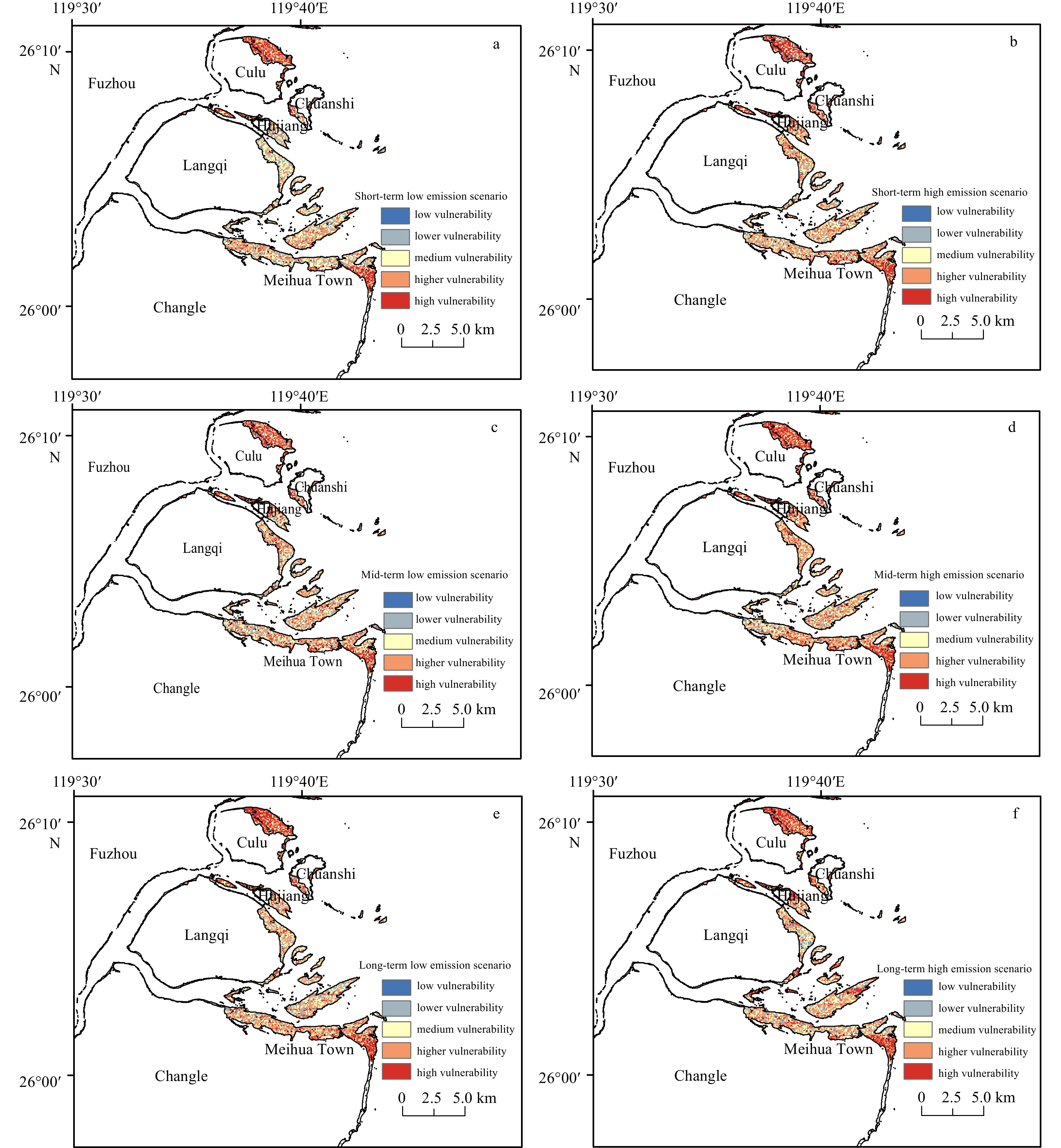
The change of coastal wetland vulnerability affects the ecological environment and the economic development of the estuary area. In the past, most of the assessment studies on the vulnerability of coastal ecosystems stayed in static qualitative research, lacking predictability, and the qualitative and quantitative relationship was not objective enough. In this study, the “Source-Pathway-Receptor-Consequence” model and the Intergovernmental Panel on Climate Change vulnerability definition were used to analyze the main impact of sea level rise caused by climate change on coastal wetland ecosystem in Minjiang River Estuary. The results show that: (1) With the increase of time and carbon emission, the area of high vulnerability and the higher vulnerability increased continuously, and the area of low vulnerability and the lower vulnerability decreased. (2) The eastern and northeastern part of the Culu Island in the Minjiang River Estuary of Fujian Province and the eastern coastal wetland of Meihua Town in Changle District are areas with high vulnerability risk. The area of high vulnerability area of coastal wetland under high emission scenario is wider than that under low emission scenario. (3) Under different sea level rise scenarios, elevation has the greatest impact on the vulnerability of coastal wetlands, and slope has less impact. The impact of sea level rise caused by climate change on the coastal wetland ecosystem in the Minjiang River Estuary is mainly manifested in the sea level rise, which changes the habitat elevation and daily flooding time of coastal wetlands, and then affects the survival and distribution of coastal wetland ecosystems.
Analysis of wave shoaling and shore-breakers on a low tide terrace beach based on in-situ measurements at Xisha Bay on South China coast
Yuan Li, Chi Zhang, Hongshuai Qi, Jiacheng Song, Weiqi Dai, Shanhang Chi, Jian Shi, Dake Chen
2023, 42(7): 175-184. doi: 10.1007/s13131-023-2188-4
Abstract:
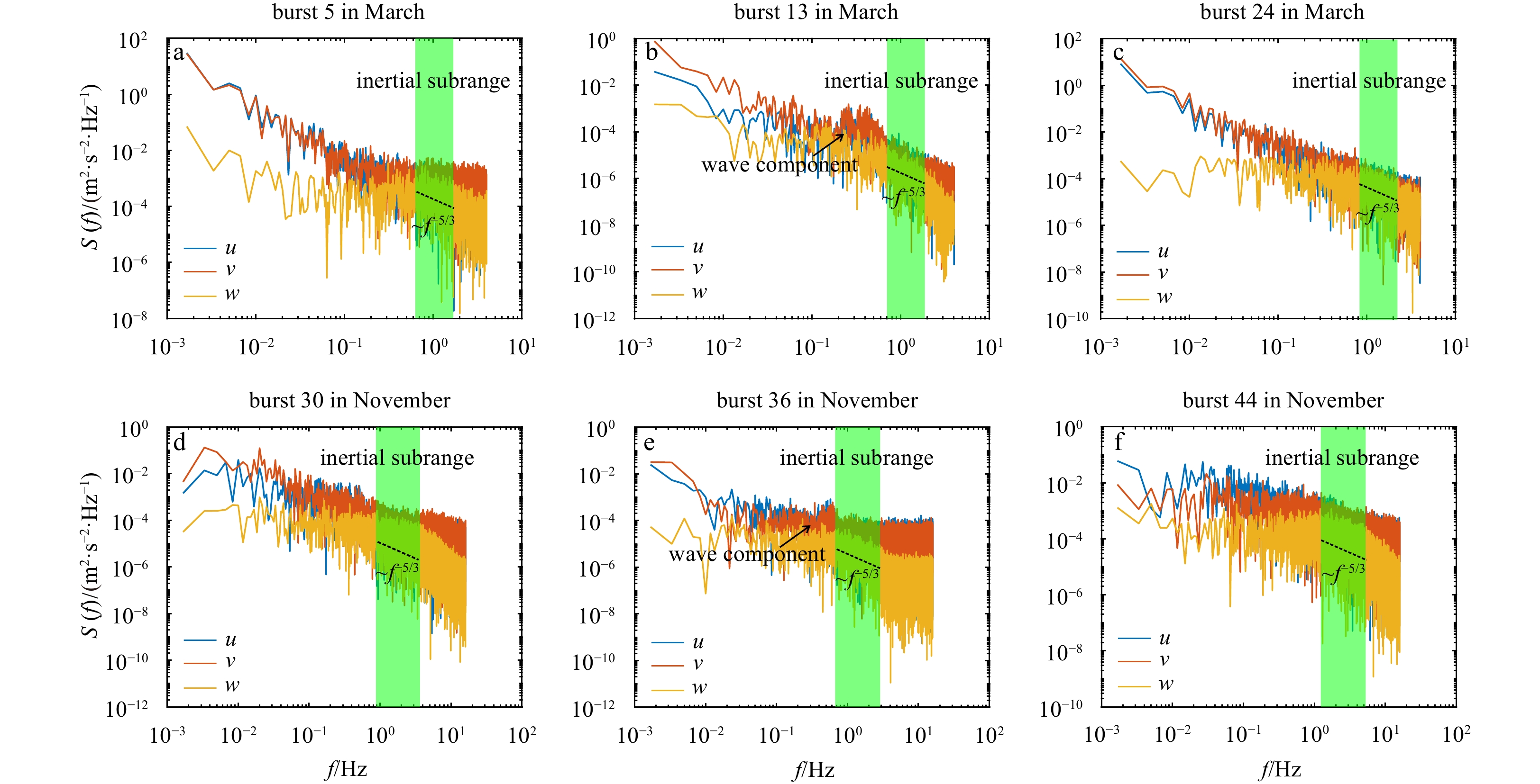
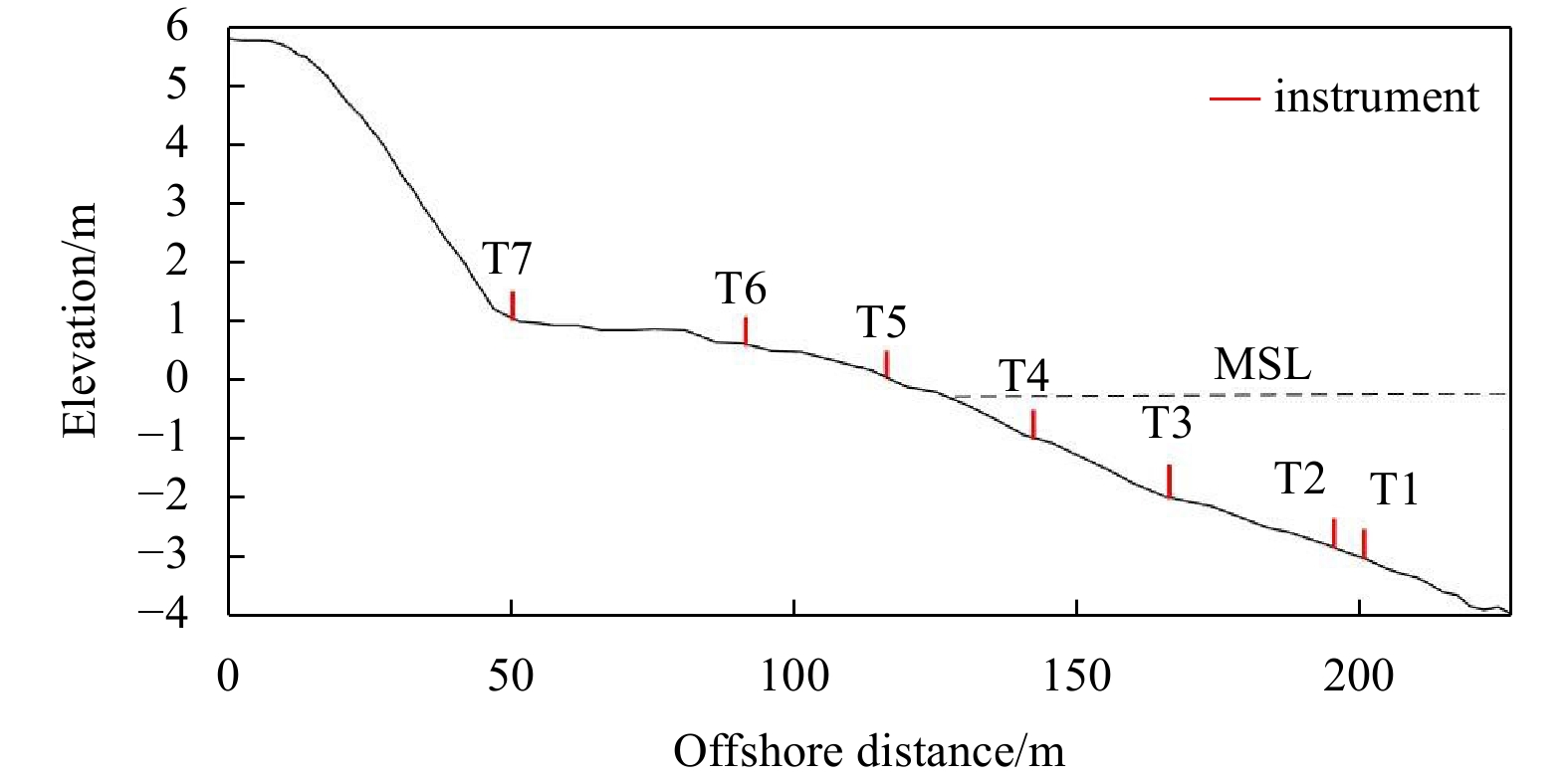
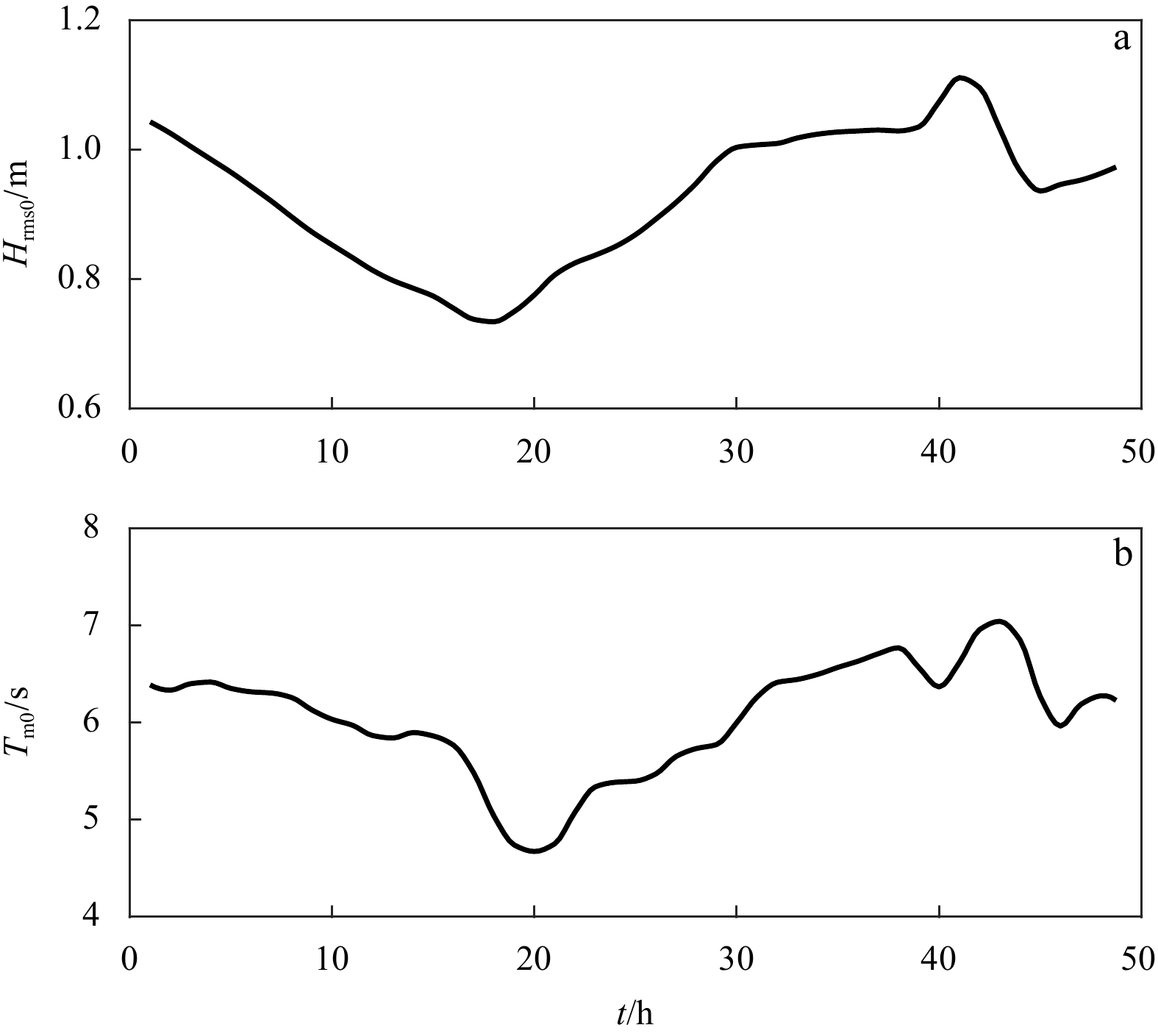
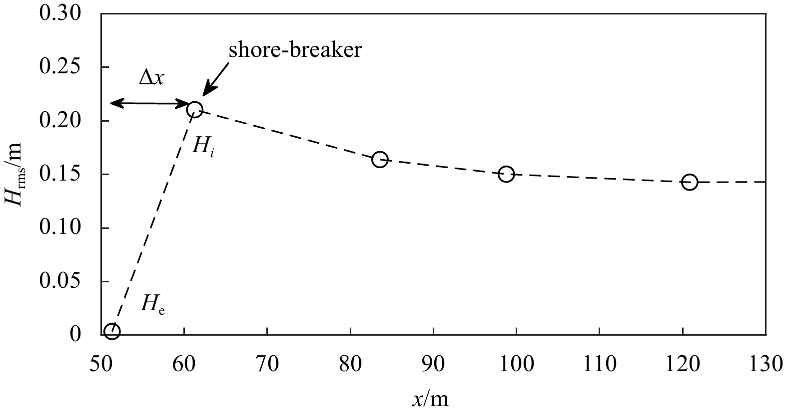
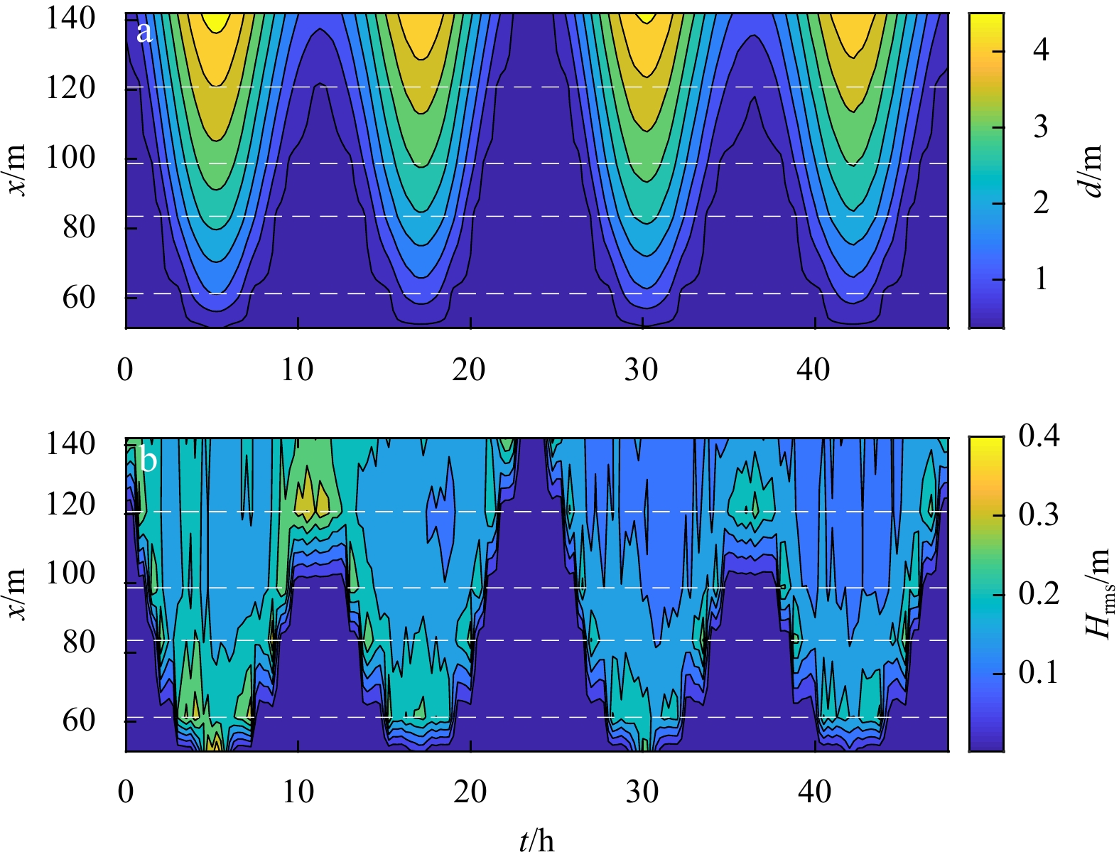
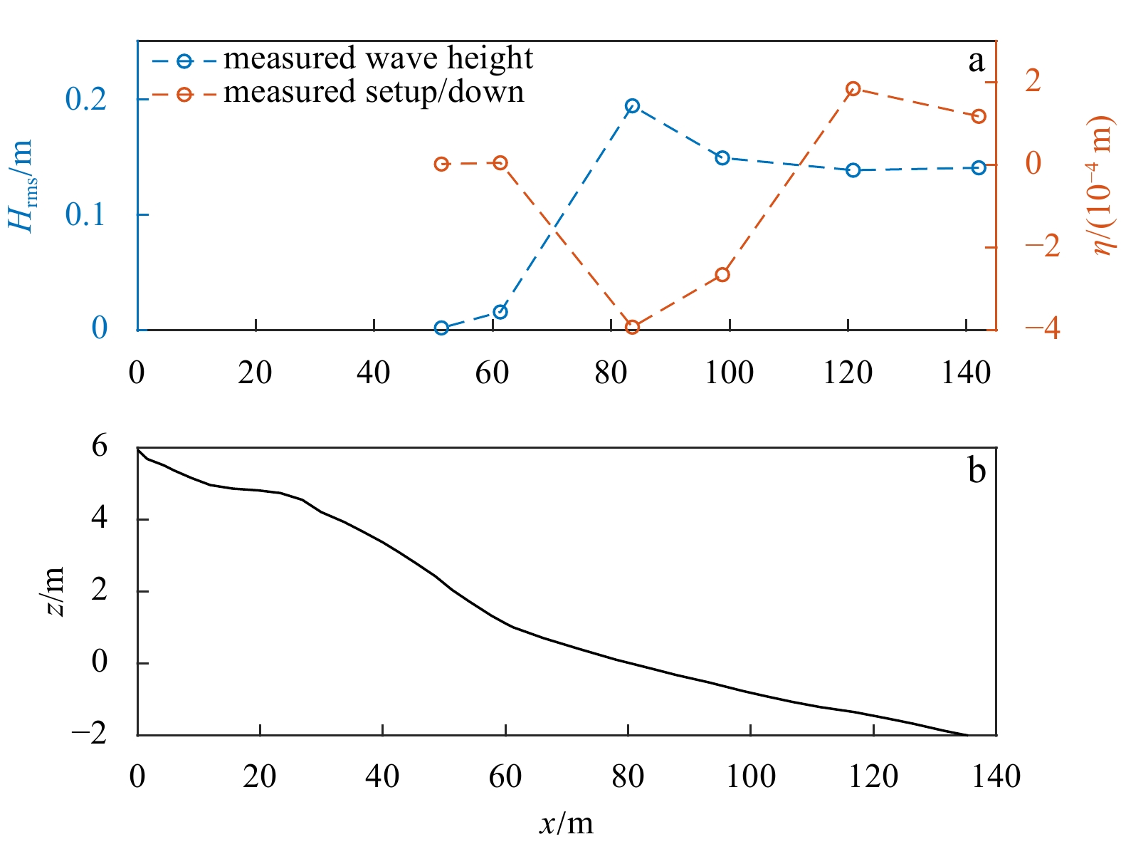
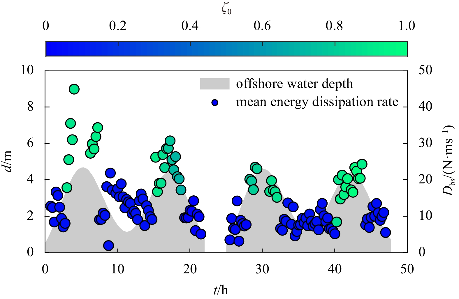
Low tide terrace beach is a main beach type along South China coasts with strong tidal actions. How strong tides affect wave transformations on low tide terrace beach still remains unclear. In this study, in-situ measurements are conducted on the low terrace beach at Xisha Bay to provide quantitative descriptions of wave shoaling and shore-breaker phenomena under the tidal effects. It is found that wave breaking is unsaturated on the low tide terrace beach at Xisha Bay. Magnitudes of wave skewness and asymmetry increase as wave shoals and achieve the maximum value at the shore-breaker, and then decrease rapidly. Mean energy dissipation rates of shore-breakers are tide-modulated since the bottom slope changes at the shoreward boundary of wave propagation in a tidal cycle. The remaining wave energy flux at the initialization of the shore-breaker is 1%–12% of offshore wave energy flux, and the energy flux ratio decreases with increasing offshore wave heights. Wave attenuation at shore-breakers can be estimated directly from offshore wave conditions based on findings in this study, favoring designs of seawalls or beach nourishment projects. Field datasets on wave transformations can also be used for verifications of wave numerical models.
Effect of fence opening configurations on dune development
Qingqian Ning, Bailiang Li, Changmao Zhou, Yanyu He, Jianhui Liu
2023, 42(7): 185-193. doi: 10.1007/s13131-023-2192-8
Abstract:
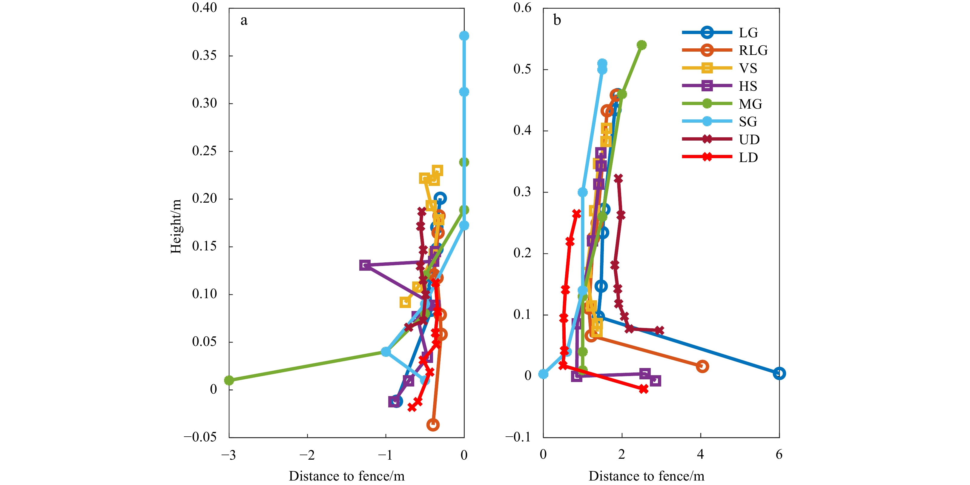
Fences have been widely used in coastal protection engineering for their low cost, simple deployment, and easy integration with ecosystems. The effects of fence porosity and height on dune development have been investigated while not much attention has been paid to the effects of fence opening configurations, such as opening size and geometry, and porosity distributions. In this study, we deployed eight fences with same height and similar porosity, but different opening configurations on a sandy beach in Pingtan, Fujian Province. Results indicate that there is a similar two-dune-one-trough pattern for all fences at the beginning of dune development, and opening size, orientation, and geometry, and porosity distribution control the leeward dune peak locations. Fences with small openings and non-uniform porosity have high trapping efficiency, and upper denser porosity may be the optimal design as these fences have the highest trapping efficiency and capacity. The conclusions from this study can provide guidance on practical fence design.