


Figure
1.
Typical SAR ISW Images obtained from Sentinel-1 (a–c) and GF-3 (d–f).
| Citation: | Jihua Liao, Keqiang Wu, Lianqiao Xiong, Jingzhou Zhao, Xin Li, Chunyu Zhang. Dissolution mechanism of a deep-buried sandstone reservoir in a deep water area: A case study from Baiyun Sag, Zhujiang River (Pearl River) Mouth Basin[J]. Acta Oceanologica Sinica, 2023, 42(3): 151-166. doi: 10.1007/s13131-022-2142-x

|
The Malacca Strait with 1 080 km long is the most important energy transport route. Due that the internal solitary waves (ISWs) have great influence on the navigation of ships and submarines, especially, Malacca Strait is the area where the ISWs occur frequently, it is necessary to study the characteristics of the ISWs in Malacca Strait.
It is well known that ISWs phenomenon shows strong randomness, and its amplitude, propagation velocity and wavelength are greatly affected by hydrology and other external environment (Fang and Du, 2005; Li et al., 2013; Alford et al., 2010; Cai and Xie, 2010; Huang et al., 2007; Hyder et al., 2005; Lai et al., 2010). The research of ISWs based on SAR image usually includes the following two aspects. One is to study the temporal and spatial distribution of ISWs. For example, in 2000, Hsu et al. (2000) studied the distribution of ISWs in the South China Sea based on 5-year satellite remote sensing images. Using satellite SAR data from July to October 2007, Kozlov et al. (2015) studied the characteristics of short-period ISWs in the Kara Sea. Filonov et al. (2014) studied the spatial distribution of ISWs of Todos Santos by means of the combination of real measurement and remote sensing. Another one is the imaging mechanism of ISWs on SAR image and the inversion of ISWs parameters. For example, in 2013, Liu et al. (2013) calculated the nonlinear phase velocity of the ISWs in the South China Sea using multi-source remote sensing data, and found that the velocity of the ISWs was greatly affected by the depth of water. In 2016, combined with nonlinear Schrodinger (NLS) equation, our team obtained the inversion model of SAR ISWs parameters, and the inversion results are close to the measured data (Zhang et al., 2016). With the increasing number of satellites in orbit, the understanding of ISWs by multi-source remote sensing becomes to be more and more comprehensive (Jackson, 2007; Schuler et al., 2003).
In a word, there is no research on the ISWs in Malacca Strait up to date. In this paper, ISWs in Malacca Strait are investigated from the spatial distribution of the waves, the velocity and amplitude of the ISWs, and so on, which will provide valuable scientific references for maritime navigation and marine engineering.
The Malacca Strait is located in the region of 0°–6°N and 97°–104°E. In order to observe and analyze the characteristics of ISWs in the Malacca Strait, Sentinel-1 SAR data from June 2015 to December 2016 and GF-3 data from April 2018 to March 2019 are collected. Because of the limitation of SAR orbital period, we obtain 20 Sentinel-1 images and 24 GF-3 images in total, and 344 ISW packets and ISWs are collected.
It can be seen from Fig. 1 that the ISWs in the Malacca Strait mainly appear in the form of wave packets and single solitary waves. Though the direction of ISWs propagation seems to be very complex, however, it always tends to propagate towards the shore.
Furtherly, according to the position and the crest length of the leading wave in the ISW packets in 45 SAR images, the spatial distribution of the wave and the length distribution of the leading wave crest in the Malacca Strait are obtained, which are shown in Fig. 2 and Fig. 3, respectively. As shown in Fig. 2, in region A, the depth of water in this area is about 50–100 m, and the largest wave packets is observed, accompany with a relatively long crest length of the leading wave. In the middle of the Malacca Strait (region B), the water depth is about 20–50 m, the ISW propagates in the form of wave packets and single solitary waves, and the crest length of the leading wave becomes shorter. In the southeast of the Malacca Strait (region C), the water depth is relatively shallow, with the shallowest part of only 4 m, and the ISW is mostly in the form of wave packets and single solitary waves, with the shortest crest length of the leading wave, but it is noticing that the ISWs is broken seriously, and the direction of the ISWs is also relatively messy.


By observed from satellite images, it can be found that there are three to seven ISWs on average in the Malacca Strait, with a maximum of 12 ISWs. The maximum (minimum) crest length of the wave packet is about 39 km (1.5 km) in the Fig. 2, and the crest length of the leading wave becomes to be shorter and shorter towards the southeast. Totally, 344 crest length of the leading wave are observed, in which 35 lines are more than 20 km in length, and most of them are located in the northwest region. In addition, most crest length of the leading wave less than 20 km are located in the regions B and C, and the number of crest length of the leading wave from 4 km to 14 km is about 273 crest lines, which accounts for the vast majority of total lines.
In addition, the occurrence of ISWs has a great relationship with seasons. Figure 4 shows the distribution of ISWs in different seasons. The largest number of ISWs observed from remote sensing images occurred from January to march, and the smallest from October to December. Most of the ISWs observed in SAR images from April to September occurred in region C.

The inversion of the ISWs parameters greatly depends on the two layer stratification. Temperature, salt and density data of the studied area are selected from the annual average data of World Ocean Atlas (2013), and hierarchical information is obtained by calculating the vertical distribution. The calculated temperature, salinity, density and buoyancy frequency curve are showed in Fig. 5. The water depth corresponding to the inflection point of buoyancy frequency in Fig. 5d is the upper water depth, about 25 m. The density corresponding to the upper water depth is found in the density curve, and the upper and lower average densities are calculated as 1 019.9 kg/m3 and 1 020.9 kg/m3 respectively.

Because of the balance between nonlinear effect and dispersion effect, the ISWs can be stable and spread over long distance.
The ISWs propagation equation adopts NLS equation. Combined with the SAR imaging mechanism of the ISWs, the amplitude inversion model of the ISWs based on the SAR image is established (NLS equation) (Zhang et al., 2016).
| $$\left\{ \begin{split} & D = 1.76l,\qquad \alpha \beta > 0\\ & D = 1.32l,\qquad \alpha \beta < 0 \end{split} \right.,$$ | (1) |
| $$\left\{ \begin{split} & {A_0} = \frac{{1.76}}{D}\sqrt {\left| {\frac{{2\alpha }}{\beta }} \right|},\qquad \alpha \beta > 0\\ & {A_0} = \frac{{1.32}}{D}\sqrt {\left| {\frac{{2\alpha }}{\beta }} \right|},\qquad \alpha \beta < 0 \end{split} \right.,$$ | (2) |
where A0 is the amplitude of the ISWs,
Then we apply the NLS amplitude inversion model to the previous 45 SAR images, and extract the distance D between the brightest spot and the darkest spot and hydrological parameters from each SAR image. The amplitude A0 of ISWs can be obtained from Eq. (2). We calculate the amplitude of ISWs happened in the Malacca Strait with water depth greater than 30 m.
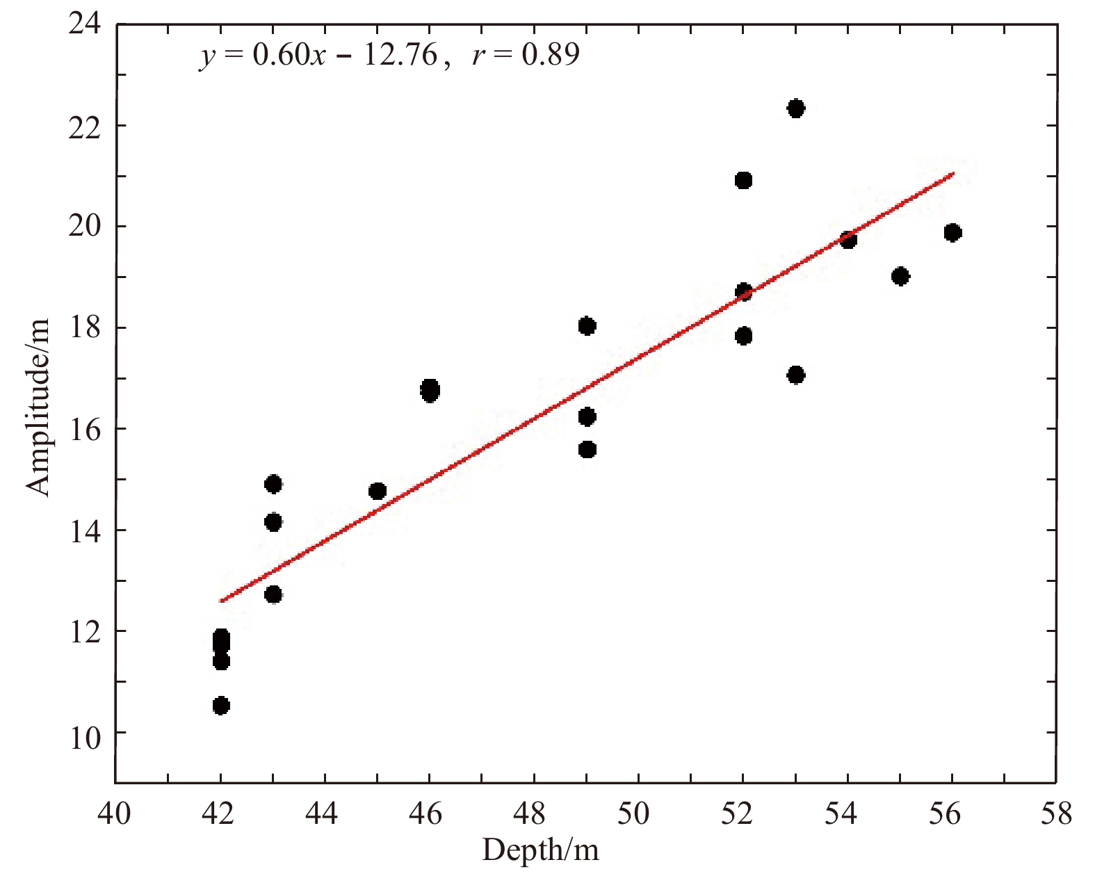
By extracting the characteristic parameters of ISWs in the Malacca Strait, the amplitude distribution is obtained, as shown in Fig. 6. In region A, the maximum amplitude obtained by NLS amplitude inversion model is 23.9 m, which is located at the water depth of 78 m, and the average amplitude of ISWs in this area is about 18.4 m. The maximum amplitude in region B calculated by NLS amplitude inversion model is 17.9 m, the minimum amplitude is 4.7 m, and the average amplitude of ISWs is about 10.9 m. The water depth in region C is shallow. The maximum and minimum amplitude calculated by NLS amplitude inversion model are 14.1 m and 4.7 m respectively, and the average amplitude is 9.6 m. In addition, we also analyze the amplitude of the one ISW. Figure 7 is a SAR image from March 14, 2016, we extracted the parameter and calculated the amplitude of ISWs. Each red dot in Fig. 7 is the extraction position of the ISWs parameter, combined with the local depth of water, the relationship between amplitude and depth of water is shown in Fig. 8. From Fig. 8, it can be found that even in the same ISW, the amplitude of ISWs is different, and the amplitude distribution is linearly related to the water depth. Figures 4 and 8 show that in Malacca Strait, with the decrease of water depth, the amplitude decreases. This may be due to the increase of the nonlinear effect of ISWs with the shallow water depth, which leads to the breakage of ISWs.

ISWs in the Malacca Strait can be divided into two types: single solitary waves and solitary wave packets. Therefore, we use NLS equation to derive the group velocity of solitary wave packets and KdV equation to obtain the phase velocity of single solitary waves.
The group velocity formula derived from the NLS equation (Zhang et al., 2015) is
| $${c_g} = \frac{{\rm d\omega }}{{\rm dk}} = \frac{\omega }{{2k}}\left[ {1 + \frac{{2k{h_2}}}{{ {\rm {sh}}(2k{h_2})}}} \right] ,$$ | (3) |
where k is the wave number, h2 is the depth of the lower layer, and
The phase velocity formula obtained by KdV equation (Zheng et al., 2001) is
| $$c = {\left[ {\frac{{g({\rho _2} - {\rho _1}){h_1}{h_2}}}{{{\rho _2}{h_1} + {\rho _1}{h_2}}}} \right]^{1/2}} + \frac{{\alpha {A_0}}}{3}, $$ | (4) |
where hl and h2 are the thickness of the upper and lower layers, respectively, and their water densities are
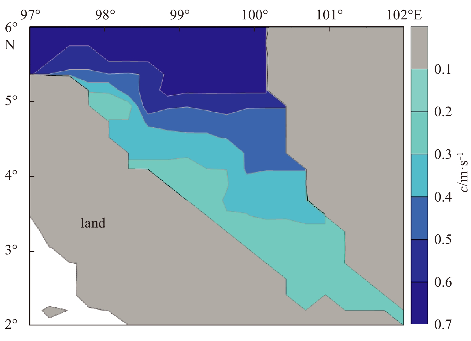
The propagation velocity of ISWs is affected by many factors, such as water depth, stratification. The two-dimensional water depth distribution map of Malacca Strait has been given in Fig. 2. It can be seen that the depth of the water in the south is the shallower, and the deeper is to the northwest. The distribution characteristics of the group velocity and the phase velocity in Malacca Strait are analyzed. Figure 9 shows the group velocity distribution of ISWs in Malacca Strait calculated by using the group velocity formula derived from the NLS equation. Figure 10 shows the distribution of phase velocity calculated by KdV equation.

As can be seen from Fig. 9, the group velocity of the wave packets reduced from 0.4 m/s to 0.12 m/s and the phase velocity of ISWs in Fig. 10 decreases from 0.6 m/s to 0.26 m/s. In general, the group velocity and phase velocity of ISWs in Malacca Strait are related to the topography.

Based on the Sentinel-1 and GF-3 SAR data, totally 45 SAR images in Malacca Strait are obtained, and the characteristic parameters of the ISWs in Malacca Strait are studied. The distribution of ISWs and crest length of the leading waves in Malacca Strait are statistically analyzed. It is found that ISWs are present in most of Malacca Strait, and the ISWs appear in the form of wave packets and single solitary waves. Furthermore, the direction of ISWs propagation is more complex, but the ISWs always tends to propagate towards the shore. The crest length of the leading wave is the longest in the northwest.
In addition, the group velocity and amplitude distributions of the area are calculated based on the high-order completely NLS equation inversion model. The phase velocity is obtained by KdV equation. The group velocity and phase velocity of ISWs are closely related to water depth and stratification. From northwest to southeast, with the water depth becoming shallow, the group velocity and phase velocity of ISWs becomes smaller. The group velocity distribution is between 0.12 m/s and 0.40 m/s, the phase velocity distribution is between 0.26 m/s and 0.6 m/s, and the amplitude of the ISWs is in the range of 4.7–23.9 m. The general trend of the amplitude and velocity is decreasing, which indicates that with the depth of water decreases, the nonlinearity increases, leading to the breakup of ISWs.
|
Chen Guojun, Du Guichao, Zhang Gongcheng, et al. 2009. Diagenesis and main factors controlling the tertiary reservoir properties of the Panyu Low-Uplift Reservoirs, Pearl River Mouth Basin. Natural Gas Geoscience (in Chinese), 20(6): 854–861
|
|
Chen Ronghua, Xu Jian, Meng Yi, et al. 2003. Microfossils, carbonate lysocline and compensation depth in surface sediments of the northeastern South China Sea. Acta Oceanologica Sinica, 22(4): 597–606
|
|
Chuhan F A, Bjørlykke K, Lowrey C. 2000. The role of provenance in illitization of deeply buried reservoir sandstones from Haltenbanken and north Viking Graben.off shore Norway. Marine and Petroleum Geology, 2000, 17: 673-689
|
|
Ding Xiaoqi, Han Meimei, Zhang Shaonan, et al. 2014. Roles of meteoric water on secondary porosity of siliciclastic reservoirs. Geological Review (in Chinese), 60(1): 145–158
|
|
Ehrenberg S G. 1989. Assessing the relative importance of compaction processes and cementation to reduction of porosity in sandstones: Discussion; Compaction and porosity evolution of Pliocene sandstones, Ventura Basin, California: Discussion1. AAPG Bulletin, 73(10): 1274–1276
|
|
El-Ghali M A K, Mansurbeg H, Morad S, et al. 2006. Distribution of diagenetic alterations in fluvial and paralic deposits within sequence stratigraphic framework: Evidence from the Petrohan Terrigenous Group and the Svidol Formation, Lower Triassic, NW Bulgaria. Sedimentary Geology, 190(1–4): 299–321
|
|
Feng Jiarui, Gao Zhiyong, Cui Jinggang, et al. 2016. The exploration status and research advances of deep and ultra-deep clastic reservoirs. Advances in Earth Science (in Chinese), 31(7): 718–736
|
|
Fu Jian. 2019. The study of hydrocarbon generation mechanism of source rocks and origin of oil in the Baiyun Sag, Pearl River Mouth Basin (in Chinese)[dissertation]. Beijing: China University of Petroleum (Beijing).
|
|
Han Yinxue, Chen Ying, Yang Haizhang, et al. 2017. “Source to sink” of Enping Formation and its effects on oil and gas exploration in Baiyun Sag, Pearl River Mouth Basin. China Petroleum Exploration (in Chinese), 22(2): 25–34
|
|
Hayes M J, Boles J R. 1993. Evidence for meteoric recharge in the San Joaquin Basin, California provided by isotope and trace element chemistry of calcite. Marine and Petroleum Geology, 10(2): 135–144. doi: 10.1016/0264-8172(93)90018-N
|
|
He Dengfa, Ma Yongsheng, Liu Bo, et al. 2019. Main advances and key issues for deep-seated exploration in petroliferous basins in China. Earth Science Frontiers (in Chinese), 26(1): 1–12
|
|
Huang Sijing, Huang Keke, Feng Wenli, et al. 2009. Mass exchanges among feldspar, kaolinite and their influences on secondary porosity formation in clastic diagenesis—A case study on the Upper Paleozoic, Ordos Basin and Xujiahe Formation, Western Sichuan Depression. Geochimica (in Chinese), 38(5): 498–506
|
|
Jia Chengzao, Pang Xiongqi. 2015. Research processes and main development directions of deep hydrocarbon geological theories. Acta Petrolei Sinica (in Chinese), 36(12): 1457–1469
|
|
Jiang Wenmin, Li Yun, Yang Chao, et al. 2021. Organic geochemistry of source rocks in the Baiyun Sag of the Pearl River Mouth Basin, South China Sea. Marine and Petroleum Geology, 124: 104836. doi: 10.1016/j.marpetgeo.2020.104836
|
|
Jin Xiaohui, Lin Qing, Fu Ning, et al. 2013. Impact of CO2 on formation and distribution of gas hydrate in northern South China Sea. Petroleum Geology & Experiment (in Chinese), 35(6): 634–639,645
|
|
Ketzer J M, Holz M, Morad S, et al. 2003. Sequence stratigraphic distribution of diagenetic alterations in coal-bearing, paralic sandstones: evidence from the Rio Bonito Formation (early Permian), southern Brazil. Sedimentology, 50(5): 855–877. doi: 10.1046/j.1365-3091.2003.00586.x
|
|
Kong Lingtao, Chen Honghan, Ping Hongwei, et al. 2018. Formation pressure modeling in the Baiyun Sag, northern South China Sea: Implications for petroleum exploration in deep-water areas. Marine and Petroleum Geology, 97: 154–168. doi: 10.1016/j.marpetgeo.2018.07.004
|
|
Kriete C, Suckow A, Harazim B. 2004. Pleistocene meteoric pore water in dated marine sediment cores off Callao, Peru. Estuarine, Coastal and Shelf Science, 59(3): 499–510
|
|
Lei Chuan, Luo Jinglan, Pang Xiong, et al. 2018a. Impact of temperature and geothermal gradient on sandstone reservoir quality: the Baiyun Sag in the Pearl River Mouth Basin study case (northern South China Sea). Minerals, 8(10): 452. doi: 10.3390/min8100452
|
|
Lei Chao, Ren Jianye, Pang Xiong, et al. 2018b. Continental rifting and sediment infill in the distal part of the northern South China Sea in the western Pacific region: Challenge on the present-day models for the passive margins. Marine and Petroleum Geology, 93: 166–181. doi: 10.1016/j.marpetgeo.2018.02.020
|
|
Li Youchuan, Fu Ning, Zhang Zhihuan. 2013. Hydrocarbon source conditions and origins in the deepwater area in the northern South China Sea. Acta Petrolei Sinica (in Chinese), 34(2): 247–254
|
|
Li Chi, Luo Jinglan, Hu Haiyan, et al. 2019. Thermodynamic impact on deepwater sandstone diagenetic evolution of Zhuhai Formation in Baiyun Sag, Pearl River Mouth Basin. Earth Science (in Chinese), 44(2): 572–587
|
|
Liao Jihua, Xu Qiang, Chen Ying, et al. 2016. Sedimentary characteristics and genesis of the deepwater channel system in Zhujiang Formation of Baiyun-Liwan Sag. Earth Science (in Chinese), 41(6): 1041–1054
|
|
Liu Baojun, Pang Xiong, Yan Chengzhi, et al. 2011. Evolution of the Oligocene−Miocene shelf slope-break zone in the Baiyun deep-water area of the Pearl River Mouth Basin and its significance in oil-gas exploration. Acta Petrolei Sinica (in Chinese), 32(2): 234–242
|
|
Long Zulie, Chen Cong, Ma Ning, et al. 2020. Geneses and accumulation characteristics of hydrocarbons in Baiyun Sag, deep water area of Pearl River Mouth Basin. China Offshore Oil and Gas (in Chinese), 32(4): 36–45
|
|
Lyu Chengfu, Chen Guojun, Du Guichao, et al. 2014. Diagenesis and reservoir quality evolution of shelf-margin sandstones in Pearl River Mouth Basin, South China Sea. Journal of Petroleum Science and Technology, 4(1): 1–19
|
|
Lyu Chengfu, Chen Guojun, Zhang Gongcheng, et al. 2011. Reservoir characteristics of detrital sandstones in Zhuhai formation of Baiyun Sag, Pearl River Mouth Basin. Journal of Central South University (Science and Technology) (in Chinese), 42(9): 2763–2773
|
|
Ma Ming, Chen Guojun, Li Chao, et al. 2017. Quantitative analysis of porosity evolution and formation mechanism of good reservoir in Enping Formation, Baiyun Sag, Pearl River Mouth Basin. Natural Gas Geoscience (in Chinese), 28(10): 1515–1526
|
|
Mansurbeg H, El-ghali MAK, Morad S, et al. 2006. The impact of meteoric water on the diagenetic alterations in deep-water, marine siliciclastic turbidites. Journal of Geochemical Exploration, 89(1–3): 254–258
|
|
Meng Yi, Chen Ronghua, Zheng Yulong. 2002. Foraminifera in surface sediments of the Bering and Chukchi Seas and their sedimentary environment. Acta Oceanologica Sinica, 21(1): 67–76
|
|
Mi Lijun, He Min, Zhai Puqiang, et al. 2019. Integrated study on hydrocarbon types and accumulation periods of Baiyun Sag, deep water area of Pearl River Mouth Basin under the high heat flow background. China Offshore Oil and Gas (in Chinese), 31(1): 1–12
|
|
Mi Lijun, Liu Qiang, Liu Lifang, et al. 2022. Technology leads the way of carbon neutrality application of CNOOC. China Offshore Oil and Gas (in Chinese), 34(4): 1–15
|
|
Osborne M J, Swarbrick R E. 1997. Mechanisms for generating overpressure in sedimentary basins: a reevaluation. AAPG Bulletin, 81(6): 1023–1041
|
|
Pang Xiong, Chen Changmin, Peng Dajun, et al. 2008. Basic geology of Baiyun deep-water area in the northern South China Sea. China Offshore Oil and Gas (in Chinese), 20(4): 215–222
|
|
Pang Jiang, Luo Jinglan, Ma Yongkun, et al. 2019. Forming mechanism of ankerite in Tertiary reservoir of the Baiyun Sag, Pearl River Mouth Basin, and its relationship to CO2-bearing fluid activity. Acta Geologica Sinica (in Chinese), 93(3): 724–737
|
|
Pang Xiong, Ren Jianye, Zheng Jinyun, et al. 2018. Petroleum geology controlled by extensive detachment thinning of continental margin crust: A case study of Baiyun Sag in the deep-water area of northern South China Sea. Petroleum Exploration and Development, 45(1): 29–42. doi: 10.1016/S1876-3804(18)30003-X
|
|
Purvis K. 1995. Diagenesis of Lower Jurassic sandstones, Block 211/13 (Penguin Area), UK northern North Sea. Marine and Petroleum Geology, 12(2): 219–228. doi: 10.1016/0264-8172(95)92841-J
|
|
Shi Hesheng, He Min, Zhang Lili, et al. 2014. Hydrocarbon geology, accumulation pattern and the next exploration strategy in the eastern Pearl River Mouth Basin. China Offshore Oil and Gas (in Chinese), 26(3): 11–22
|
|
Tian Lixin, Zhang Zhongtao, Pang Xiong, et al. 2020. Characteristics of overpressure development in the mid-deep strata of Baiyun Sag and its new enlightenment in exploration activity. China Offshore Oil and Gas (in Chinese), 32(6): 1–11
|
|
Tong Xiaoguang, Zhang Guangya, Wang Zhaomeng, et al. 2014. Global oil and gas potential and distribution. Earth Science Frontiers (in Chinese), 21(3): 1–9
|
|
Wang Jin, Cao Yingchang, Liu Keyu, et al. 2016. Pore fluid evolution, distribution and water-rock interactions of carbonate cements in red-bed sandstone reservoirs in the Dongying Depression, China. Marine and Petroleum Geology, 72: 279–294. doi: 10.1016/j.marpetgeo.2016.02.018
|
|
Wang Xiaotao, Wang Tongshan, Li Yongxin, et al. 2015. Experimental study on the effects of reservoir mediums on crude oil cracking to gas. Geochimica (in Chinese), 44(2): 178–188
|
|
Yuan Peifang, Lu Huanyong, Zhu Zongqi, et al. 1996. Pyrolysis experiment of Eogene source rocks in Jiyang Depression. Chinese Science Bulletin (in Chinese), 41(8): 728–730
|
|
Zeng Qingbo, Chen Guojun, Zhang Gongcheng, et al. 2015. The shelf-margin delta feature and its significance in Zhuhai Formation of deep-water area, Pearl River Mouth Basin. Acta Sedimentologica Sinica (in Chinese), 33(3): 595–606
|
|
Zeng Zhiwei, Yang Xianghua, Zhu Hongtao, et al. 2017. Development characteristics and significance of large delta of Upper Enping Formation, Baiyun Sag. Earth Science (in Chinese), 42(1): 78–92
|
|
Zhang Li, Chen Shuhui. 2017. Reservoir property response relationship under different geothermal gradients in the eastern area of the Pearl River Mouth Basin. China Offshore Oil and Gas (in Chinese), 29(1): 29–38
|
|
Zhang Gongcheng, Feng Congjun, Yao Xingzong, et al. 2021. Petroleum geology in deepwater settings in a passive continental margin of a marginal sea: a case study from the South China Sea. Acta Geologica Sinica (English edition), 95(1): 1–20. doi: 10.1111/1755-6724.14621
|
|
Zhang Huolan, Pei Jianxiang, Zhang Yingzhao, et al. 2013. Overpressure reservoirs in the mid-deep Huangliu Formation of the Dongfang area, Yinggehai Basin, South China Sea. Petroleum Exploration and Development (in Chinese), 40(3): 284–293
|
|
Zhang Gongcheng, Yang Haizhang, Chen Ying, et al. 2014. The Baiyun Sag: A giant rich gas-generation sag in the deepwater area of the Pearl River Mouth Basin. Natural Gas Industry (in Chinese), 34(11): 11–25
|
|
Zhang Qin, Zhu Xiaomin, Chen Xiang, et al. 2010. Distribution of diagenetic facies and prediction of high-quality reservoirs in the Lower Cretaceous of the Tanzhuang Sag, the southern North China Basin. Oil & Gas Geology (in Chinese), 31(4): 472–480
|
|
Zhu Junzhang, Shi Hesheng, Pang Xiong, et al. 2008. Zhuhai Formation source rock evaluation and reservoired hydrocarbon source analysis in the deepwater area of Baiyun Sag, Pearl River Mouth Basin. China Offshore Oil and Gas (in Chinese), 20(4): 223–227
|
|
Zhu Ming, Zhang Xiangtao, Huang Yuping, et al. 2019. Source rock characteristics and resource potential in Pearl River Mouth Basin. Acta Petrolei Sinica (in Chinese), 40(S1): 53–68
|


Figures(16)

Supported by:
Beijing Renhe Information Technology Co. Ltd


 DownLoad:


