Figure
1.
Tectonic evolution map of the SCS and its adjacent areas (from Zhang et al., 2015a).
| Citation: | Gongcheng Zhang, Ying Chen, Dongdong Wang, Zengxue Li. Cenozoic giant coal-bearing basin belt discovered in China’s sea area[J]. Acta Oceanologica Sinica, 2023, 42(3): 101-112. doi: 10.1007/s13131-022-2134-x

|
China’s oil and gas exploration includes land and sea areas, including approximately 26 sedimentary basins in the sea area, with a total area of 161×104 km2, thus sea area is an important field of oil and gas exploration (Petroleum Geology Compilation Group, 1990; Zhang et al., 2018b, 2021b; Zhang, 2020). The basic oil and gas geological theory “source control theory” points out that the source rock is the most critical issue of oil and gas exploration (Hu, 1982). There are mainly two kinds of source rocks in China’s sea area: lacustrine source rocks and coal type source rocks (including coal seams and related terrestrial marine mudstones) (Li et al., 2012a, 2013). Prior to late 2005, it was found through exploration that the proved reserves of oil and gas from lacustrine source rocks are about 6 times that from coal type source rocks. In the past, the idea of looking for oil in lacustrine source rock basin has been used for many years to prospect natural gas in coal type source rock basin. Due to the unclear understanding of the development and distribution of coal type source rocks, the success rate of oil and gas exploration has been low. China National Offshore Oil Corporation (CNOOC) and the large international oil companies that it collaborates with discovered two large coal type gas fields (Deng and Chen, 1989; Huang, 1995), respectively in 1983 and 1995. After that, there were few breakthroughs in oil and gas exploration for a long period of time. Since 2000, CNOOC has made breakthroughs in the exploration of large oil and gas fields in the Liwan, Panyu and Liuhua areas of the Zhujiang River (Pearl River) Mouth Basin (Shi et al., 2010; Sun, et al., 2013; Zhang et al., 2018a) and Lingshui Sag of the Qiongdongnan Basin (Wang et al., 2015; Zhang et al., 2016a), whose source rocks are mainly coal type source rocks. Compared with the oil and gas generated by lacustrine hydrocarbon sources, due to the weak research on the distribution law of coal type source rocks, it is urgent that the global issue of whether coal type oil and gas can become a new field for increasing reserves, and that production in China be solved by means of innovation in theoretical understanding and prediction technology of coal type source rocks, so as to provide theoretical and technical support for the discovery of large coal type oil and gas fields.
Throughout the world, onshore coal-bearing series are mainly distributed in the stable areas within the Paleozoic and Mesozoic plates. Through the study of coal-bearing series in epicontinental basins and continental basins, many coal-forming theories have been produced, such as continental and transgressive process coal-forming theories (Diessel, 1992; Diessel et al., 2000), episodic coal-forming theory (Shao et al., 1992), transgression event coal-forming theory (Li et al., 2001), storm allochthonous coal-forming theory (Hu et al., 1997), diversity of coal accumulation types coal-forming theory (Sang et al., 2001), lag period of marine strata coal-forming theory (Shao et al., 2003), and multiple coal-forming theory (Li et al., 2015). These studies have mainly been aimed at cratons, forelands or rift basins within plates. However, due to the limitations of exploration and research conditions, in the past there has been little research on coal-forming theory on continental margin, with research on coal-forming theory in sea areas being almost completely absent. The coal-bearing basins in the China’s sea area are located in the marginal active area of the Cenozoic Eurasian plate, which has undergone multiple opening and closing processes, strong tectonic activity delete. Against this complex tectonic background, the research degree of coal-forming environment and model of the continental margin basin is low, its favorable coal-forming environment is unclear, and the development and occurrence model of coal is unknown. In addition, the basin is not in a favorable coal-forming environment and coal-forming period, and there is no coal-forming model for reference. The issues involved in coal type source rocks and coal type oil and gas accumulation and exploration technology in China’s offshore basins are very complex. At present, the type, genetic model, distribution range and scale of Cenozoic coal type source rocks in China’s offshore areas are unclear, which seriously restricts the exploration of coal type source rocks and coal type oil and gas fields in offshore areas, and has become a key scientific problem which urgently needs to be solved.
The opening and closing structure of China’s sea area refers to its tectonic response under the influence of the movement of the surrounding Indo-Australian Plate, Pacific Plate and Philippine Sea Plate in different periods and positions. The opening and closing structure of China’s sea area is specifically reflected in the following aspects: in the early Cenozoic, China’s sea area was in the “double plate convergence” system of the Eurasian Plate and Pacific Plate, and the back-arc extension of continental margin occurred uniformly, forming basin ridge type faulted basin system. In the late Eocene, the India-Eurasian collision and subduction direction of the Pacific Plate changed to NWW, and the Paleo South China Sea (Paleo-SCS) subduction zone began to subduct southward. In the late Oligocene, the Philippine Sea Plate drifted northward and rotated clockwise to wedge between the Eurasian and Pacific Plates, while the seafloor spreading of the South China Sea (SCS) began. In the middle Miocene, the Philippine Sea Plate stopped drifting northward. The collision between the Nansha Block and Borneo Block led to the Sabah Orogeny and the closure of the Paleo-SCS. Since the Pliocene, the Qinghai Tibet Plateau has rapidly uplifted, the basin has abnormally subsided, the Philippine Sea Plate‒Pacific Plate has rapidly drifted northwestward, the Taiwan arc-continent collision occurred, and the Manila trench and its adjacent areas were formed (Fig. 1) (Zhang et al., 2015a, b, 2018a, 2020, 2021a, b; Tang et al., 2021; Tian, et al., 2021).
Under the action of these tectonic responses, China’s sea area has undergone multiple episodes of Paleogene rifting, Neogene Quaternary depression and compression inversion to varying degrees, forming 26 Cenozoic sedimentary basins, of which 19 belong to large- and medium-sized sedimentary basins (Fig. 1). These Cenozoic sedimentary basins are mainly developed in two geotectonic environments, namely the inner and outer edges of the continental plate. The Bohai Bay Basin (sea area), South Yellow Sea Basin, northern part of the Zhujiang River Mouth Basin, Beibu Gulf Basin, Mekong Basin and other continental basins located on the inner edge of the continental plate are dominated by lacustrine source rocks. Meanwhile, the basins located on the outer edge of the continental plate can be further divided into active continental margin basins, passive continental margin basins, transformed continental margin basins and rift basins on drifting blocks. A total of 14 marginal coal-bearing basins have been formed there, mainly generating coal type oil and gas, forming a very large coal-bearing basin in China’s sea area.
The active continental margins in the giant coal-bearing basin in China’s sea area include the continental margin of the East China Sea and southern continental margin of the SCS. The corresponding basins include the East China Sea Basin, Taixi Basin, Palawan Basin, Brunei-Sabah Basin and Zengmu Basin. The passive continental margin is the northern continental margin of the SCS, and the corresponding basins include the southwest Taiwan Basin, the southern Zhujiang River Mouth Basin and Qiongdongnan Basin. The transitional continental margin is the western continental margin of the SCS, and the corresponding basins include the Yinggehai Basin, Zhongjiannan Basin and Wan’an Basin. The drift rift basins are basins on the Nansha Block, including the Liyue Basin, Beikang Basin and Nanweixi Basin (Fig. 1).
Coal-bearing basins in the giant coal-bearing basin belt in China’s sea area are drilled with coal type source rocks, and the coal type source rocks are generally medium- to high-quality source rocks. Well PY33-1-1, located in the north slope of Baiyun Sag in the Zhujiang River Mouth Basin in the northern part of the SCS, reveals 18 coal seams in the Enping Formation, with a single layer thickness of 0.70−2.14 m, a cumulative thickness of 21 m, a maximum TOC of 63% and a hydrocarbon generation potential of nearly 200 mg/g (Zhang et al., 2014a; Mi et al., 2018; Zhao et al., 2021b). Several drilling wells in the Qiongdongnan Basin have revealed coal seams. For example, Well YC13-1-2 revealed 38 coal seams in the Yacheng Formation-Lingshui Formation, with a single layer thickness of 0.3−1.0 m, a cumulative thickness of 22.1 m, the TOC of coal samples drilled in the basin up to 95.9%, and the hydrocarbon generation potential of 299 mg/g, thus indicating that it is a medium-good source rock (Li et al., 2010, 2012b; Huang et al., 2012; Zhang et al., 2010; Zhao, et al., 2021a). The coal seams in the south-central part of the SCS are more widely developed. Well D35 in the East Balinjian Depression of the Zengmu Basin reveals that the thickness of a single layer of Oligocene coal seam may exceed 1 m, and the hydrocarbon generation potential of coal samples can reach 291 mg/g (Yang et al., 2010). Coal fields are also developed in the Sarawak land area and Brunei-Sabah land area (such as the Merit-Pila coal field). The average hydrocarbon generation potential of coal samples drilled in the Brunei-Sabah Basin is 289 mg/g, thus indicating high-quality source rock (Liu et al., 2018)
The development area of coal type source rock is affected by paleolatitude, paleoclimate, paleogeography, paleoenvironment, etc. Generally speaking, the low latitude area is most conducive to coal formation, and the humid and hot climate, lush vegetation, flat and broad terrain and closed environment in the low latitude area more easily form coal. Therefore, the river-delta system, particularly the delta plain, forms coal most easily. Under the configuration of these control factors, there are five coal-forming periods in China’s sea area: Paleocene, Eocene, early Oligocene, late Oligocene and Miocene-Pliocene (Table. 1). These coal-forming periods have formed 16 medium- and large-sized coal type source rock development areas in China’s sea area basin, with the gradual southward migration of the favorable climate zone for coal formation (Li, 2009), the coal-forming environment also continues to migrate southward, resulting in the coal-forming age of the China Sea Basin becoming newer from north to south.
| Content period | Paleocene | Eocene | Early Oligocene | Late Oligocene | Miocene‒Pliocene |
| Typical basin | East China Sea Basin, Taixi Basin | Xihu Depression Nansha drift basin | Zhujiang River Mouth Basin Qiongdongnan Basin, | Wan’an Basin, Zengmu Basin | Yinggehai Basin, Zengmu Basin, Brunei-Sabah Basin |
| Coal-bearing strata | Lingfeng Fm., Mingyuefeng Fm., Mushan Fm., Daliao Fm., Shidi Fm., Nangang Fm., Nanzhuang Fm. | Pinghu Fm. Nanwei Group | Enping Fm., Yacheng Fm. | Xiwei Group Zengmu Fm. | Lidi Fm. Stage IVA |
| Paleoclimate | temperate climate, early dry heat, late warm humid‒dry heat‒warm humid alternating | subtropical climate, warm, vertical with warm wet‒dry heat‒warm wet alternating | subtropical climate, hot and humid | tropical climate, hot and humid with gradual cooling | subtropical climate, hot and humid |
| Paleobotany | terrestrial higher plants dominated | terrestrial higher plants dominated; temperate type, wet‒hot type plants mixed | mainly subtropical evergreen deciduous broad-leaved forest | higher plants dominated by mangroves | higher plants dominated by mangroves |
| Paleostructure | continental margin rifting stage, fault basins developed, with the strongest rifting in the South Yellow Sea and the western East China Sea | rifting was strengthened, and the fault depression developed very well, forming the Pinghu fault depression in the East China Sea | Enping fault depression was formed in the north of Zhujiang River Mouth Basin, uplift and denudation in the west sag of the Donghai Basin, and subsidence in the east formed continental fault depression | new South China Sea began to expand and the Paleo South China Sea began to shrink | Yellow Sea and East China Sea entered a period of regional subsidence, the expansion of the new South China Sea reached its peak, and the ancient South China Sea continued to shrink |
| Paleogeography | marine facies, marine-continental transition facies | marine facies, marine-continental transition facies | marine-continental transition facies, Marine facies | marine facies, marine-continental transition facies, continental facies | marine facies, marine-continental transition facies |
| Favorable coal-forming zone | delta plain, coastal plain | coastal plain, tidal flat swamp, lagoon siltation swamp | coastal swamp, river-lake swamp | delta plain, bay, tidal flat swamp | coastal plain, delta plain |
 DownLoad:
CSV
DownLoad:
CSV
The Paleocene coal accumulation area is mainly developed in the Taibei Depression (Shen and Qi, 2020) of the East China Sea. In the Paleocene, continental margin rifting occurred on the eastern edge of the Cathaysian Block, such as the fault depression period of Baoshi Formation of the East China Sea Basin and Wuqiuyu fault depression of the Taixi Basin, which are mainly marine or marine-continental transitional fault depressions, with the strongest rifting effect occurring in the South Yellow Sea and the western part of the East China Sea. The Lishui Sag is located in the southwestern part of the Taibei Depression of the East China Sea shelf basin, exhibits an overall NE−SW trend, and the Lishui 36-1 commercial gas field was discovered there. The sporopollen and Sr/Cu ratio of trace element shows that the Lishui Sag had a dry and hot climate in the early Paleocene, while it basically had a climate of alternating temperature and humidity-dry heat-temperature and humidity in the late Paleocene (Liu et al., 2005). The drilling and regional comparison data reveal that the lacustrine source rocks (Yin et al., 2014) of the lower Paleocene Yueguifeng Formation and terrestrial marine source rocks of the upper Paleocene Lingfeng Formation and Mingyuefeng Formation are developed in the Lishui Sag. Among them, the source rocks of the Lingfeng Formation are mainly Types II2 and III, while those of the Mingyuefeng Formation are mainly Type III with a small amount of Type II, mainly consisting of vitrinite and dominated by gas. The most important type of organic facies is mainly the coal-bearing swamp deposition under the condition of weak reduction-weak oxidation ponding medium in the sedimentary environment of pre-delta and shore shallow lake environment, and it is mainly terrigenous high plants source with a moderate organic carbon content. In terms of the thickness of source rock, that of mudstone in the Lingfeng Period reached up to 1 200 m, while the whole area was deposited during the Mingyuefeng Period, with a thickness of about 400 m (Shen and Qi, 2020; Shen et al., 2019).
Eocene coal accumulation areas were mainly developed in the Xihu Depression (Wei et al., 2012; Zhou et al., 2016; Yi et al., 2018) and drift basin (Zhang et al., 2017c) of the Nansha Block. The Eocene rifting in the China’s sea area is stronger. Eocene fault depressions are very developed in the southern and northern sides of the Paleo-SCS and the Nansha Block, forming the Pinghu fault depression in the East China Sea. The above two areas are filled with deposits of marine facies or marine-continental transitional facies. The Eocene Pinghu Formation in the Xihu Sag of the East China Sea Basin is its main source rock. More than 30 commercial gas fields have been discovered there. Paleoclimatic conditions are important factors controlling the development of source rocks in the Xihu Sag. The Xihu Sag was located on the east part of the Eurasian Plate during the Eocene of the Paleogene. The subtropical climate of this geographical location often has warm and humid climatic conditions. The sporopollen and trace elements data show that the Xihu Sag was in a warm, humid-sub humid subtropical during the sedimentary period of the Pinghu Formation, and longitudinally it has the trend of alternating “warm‒hot‒warm” (Xu et al., 2021a, b; Zhang, 2021; Shen et al., 2022). Coastal plain-tidal flat-delta-shore shallow marine facies is developed in the Pinghu Formation, and coal-bearing series are mainly developed in the coastal plain and tidal flat. Plain wetland swamp, tidal flat swamp, tidal controlled delta swamp and lagoon swamp are widely distributed in the depression, which is conducive to the development of coal seams (Shen, 2018). In addition, since the land is covered by dense foliage, the content of terrigenous debris carried by the river is very low, but it carries rich terrestrial organic matter and nutrients to the water body, which allows the aquatic phytoplankton to flourish and lays a material foundation for the formation of coal measure source rocks in the Pinghu Formation. The productivity of aquatic phytoplankton and terrestrial higher plants is one of the important factors controlling the enrichment of organic matter in sediments. High-quality source rocks can also be developed in layers lacking phytoplankton, which is mainly related to the large input of organic matter from terrestrial higher plants. There is an obvious positive correlation between tricyclic terpane ratio and organic carbon content in most samples of the Pinghu Formation in the Xihu Sag, indicating that the productivity of terrestrial higher plants controls the enrichment of organic matter in sediments to a considerable extent (Qian et al., 2012; Zhu et al., 2012; Shen et al., 2021).
During the early Oligocene coal-forming period, the coal accumulation areas are mainly developed in the Zhujiang River Mouth Basin (Zhang et al., 2014a; Gong, 2014; Yang, 2017; Li et al., 2016b, 2021a) and Qiongdongnan Basin (Li et al., 2010, 2012b; Zhang et al., 2012; Wang et al, 2020, 2021) in the northern part of the SCS. In the early Oligocene, the Enping fault depression in the northern depression belt of the Zhujiang River Mouth Basin was formed, the western depression belt of the East China Sea Basin was uplifted and denuded, and the eastern subsidence formed the Huagang continental fault depression. During the Oligocene, the northern part of the SCS had a subtropical climate. According to the sporopollen analysis data of the Enping Formation, it was located in a humid subtropical evergreen deciduous broad-leaved forest area, with a tropical lowland climate. The hot and humid climate there was conducive to the prosperity of higher plants and algae, and water was abundant. The sedimentary environment was a weak oxidation-weak reduction environment (Qin et al., 2016; Zhang et al., 2017d; Chen et al., 2022). The Enping Formation in the Baiyun Sag is a restricted marine environment. The southeastern part is connected to the ocean basin through the Liwan Sag, mainly consisting of delta facies and shallow sea facies. The northern edge of the sag is affected by the large delta entering the basin from the north of the sag. In the upper part of the Enping Formation, there is a marine-continental transitional facies environment often affected by marine transgression. The large progradational delta developed on the north slope of the Baiyun Sag was caused by the slow rise of sea level and significant increase of sediment supply under the premise of no significant tectonic movement, making it a type of equilibrium-slight overcompensation sedimentation. In this case, the rate of accumulation and thickening of plant remains was equal to or slightly higher than the rate of rising of the swamp water surface, which caused the peat layer to thicken continuously. The long-term continuation of such a situation can form thick coal seam and is conducive to the development of coal measure source rocks. The delta coal measure source rocks with sufficient material source supply in the Baiyun Sag are superior to the shallow marine mudstone source rocks. The coal measure source rocks are a set of coastal swamp facies coal-bearing series and river lake swamp facies coal-bearing series deposits, and are mainly composed of coal seams, carbonaceous mudstone and dark mudstone. Multi-layer thin coal seams are developed in the delta plain. For example, a 21 m coal seam was encountered in the Enping Formation of Panyu well 33. The delta facies coal measure strata of the Enping Formation are distributed throughout the slope zone around the depression, i.e. the (fan) delta plain around the depression, the near shore of the front edge, the gentle slope zone of the secondary depression (i.e. northwest depression, northern Panyu sub-depression, southeast depression, southwest 1 depression, southwest 2 depression, etc.), and the slope around the Dongsha Uplift, and so on. The organic matter of the coal measure delta source rocks of the Enping Formation originated from terrestrial higher plants. The organic matter type is mainly partial humic mixed type-partial humic mud mixed type, which contains abundant hydrogen-rich macerals and possesses organic matter abundance. The terrestrial marine source rocks are semi-closed marine mudstone deposits, including pre-delta and shallow marine mudstone, and marine dinoflagellates in shallow marine strata adjacent to the delta are characterized by high abundance and continuous distribution. They are mixed sources of organic matter for aquatic algae and terrestrial higher plants, provide organic matter conditions for terrestrial marine source rocks, and are medium to good source rocks, which are mainly distributed in the center of the depression and trough of the east depression (Zhu et al., 2019; Fu, 2019).
According to the analysis results of the drilled gas samples, the natural gas obtained by drilling in the deep-water area of the Qiongdongnan Basin is coal type gas, which mainly originated from coal-bearing series or terrestrial marine mudstone source rocks. Exploration practice has confirmed that the Lower Oligocene coal measure delta is an important source of hydrocarbon in the Qiongdongnan Basin. The Yacheng Formation mainly developed coastal plain, (fan) delta and coastal shallow marine sediments, while the Lingshui Formation mainly developed delta and shallow sea facies deposits. The coal-bearing series related to the Paleogene delta and terrestrial marine mudstone are the most important source rocks in the deep-water area. The Yacheng Formation coal measure delta in the northern part of the Ya’nan Sag on the north side of the Ledong Sag is the main gas source of the YA13-1 gas field. The coal-bearing series are mainly developed in the delta plain facies belt, and on the plane, it is located at the position from uplift to slope. Coal-bearing deposits are seen in the Yacheng Formation of Wells LS33-1-1 and YL19-1-1 in the deep water area, while several wells in the shallow water area in the northern part of the Qiongdongnan Basin reveal the coal seams of the Yacheng Formation, which generally exhibit high organic matter abundance (Zhang et al., 2010).
The late Oligocene coal accumulation area is mainly developed in the Wan’an Basin (Zhao et al., 2016; Zhang et al., 2017b) and Zengmu Basin (Yao et al., 2008; Yang et al., 2010; Wang et al., 2013; Xie et al., 2015) in the south-central part of the SCS. In the late Oligocene, the tectonic pattern of the SCS changed greatly, with the New-SCS beginning to expand and the Paleo-SCS beginning to shrink. The SCS exhibits significant zoning, showing the pattern of expansion of the northern New-SCS, the southward drift of the Nansha Block and the shrinking of the Paleo-SCS. The marine fault subsidence or fault depression of the Zhuhai Formation/Lingshui Formation was formed on the northern edge of the New-SCS, while the drift marine depression stratum was formed on the Nansha Block, and the compressional foreland marine-continental transitional basin was formed in the southern part of the Paleo-SCS. The southern part of the SCS had a typical tropical rainforest climate from the Eocene to Pliocene, and the warm and humid environment was conducive to the growth of higher plants. Mangroves, the tidal salt-adapted plants particular to the tropical and subtropical tidal flat in the coastal zone, are particularly prosperous there (Yang et al., 2010; Zhang et al., 2017b; Lan et al., 2021). In the Oligocene, the Wan’an Basin was dominated by extensional tectonic deformation, forming a tectonic pattern alternating between uplift and depression in the NE direction. The provenance comes from the Kunlun Uplift in the northwest of the basin. Three large coal-measure deltas are developed in the western part of the early Oligocene basin, inherited development of the delta occurred in the late Oligocene, and delta-shore shallow sea sedimentary system (Wu et al., 2012; Xiao et al., 2021) was developed.
With the expansion of the New-SCS and gradual extinction of the Paleo-SCS, the southern side of the Zengmu Block continued to collide with Borneo. The Mesozoic-Eocene strata gradually uplifted, denuded or metamorphosed to form the basement of the basin. The southern part of the Zengmu Basin was subjected to collision and compression, consequently resulting in a large uplift range in the southern part of the basing and forming a foreland orogenic belt, which provided a rich material source for the later sedimentation of the basin, formed a large coal-measure delta basin, and developed river-delta shore shallow sea sedimentary system (Guo et al., 2006, 2016; Xie et al., 2015).
Miocene and Pliocene coal accumulation areas are mainly developed in the Yinggehai Basin (Huang et al., 2002; Li et al., 2016a, c), Zengmu Basin (Yao et al., 2008; Yang et al., 2010; Wang et al., 2013; Xie et al., 2015; Li et al., 2021b) and Brunei-Sabah Basin (Zheng et al., 2014; Ma et al., 2012; Zhang, et al., 2016a; Liu et al., 2018; Li et al., 2021b; Lan et al., 2021). The major tectonic event in the Miocene was that the Yellow Sea and the East China Sea entered the regional subsidence period, which changed from the dual role of early extension and subsidence to the basin forming period dominated by subsidence, the expansion of the New-SCS in the SCS reached the peak, and the Paleo-SCS continued to shrink. The passive continental margin gradually took shape in the northern part of the New-SCS, while the active continental margin basin in the southern part of the Paleo-SCS developed. The regional tectonic background changed greatly during the late Miocene. The Paleo-SCS shrank completely, and the expansion of the New-SCS was blocked, then shrank. The Philippine Islands and Taiwan Island uplifted and thrust westward. The northern part of the SCS subsided, the southern foreland basin was strongly developed, and the significant strike slip in the west led to the large-scale development of the diapir belt. During the Miocene, the East Balinjian Sag of the Zengmu Basin developed a large delta extending from the southwest to northeast, and the delta plain was the most developed; the mangrove dominated higher plants growing along the coast and on the delta plain are covered with thin layer of water after death and are in a semi-reducing environment; sapropellization and peating occur to form coal, carbonaceous mudstone and dark mudstone, which become the source rock of coal-bearing series (Yang et al., 2010; Zhang et al., 2017a). From the middle Miocene to the early Miocene, sufficient material sources led to the development of three stages of large-scale deltas in the Brunei-Sabah Basin, which laid a good foundation for the formation of coal measure source rocks. At the same time, due to the rapid supply of sediment across the shelf slope break, large-scale turbidites were developed in the deep-water area of the continental slope. The formation process of these turbidites can carry much higher plant debris enriched in the delta to the ocean for redeposition, which provides a material basis for the formation of terrigenous marine source rocks. In addition, the formation process also transports the organic rich sediments formed in the early stage of the delta plain to the deep water area in the form of turbidity current, accompanied by turbidite deposition to form the coal-bearing turbidite mixed in the turbidite. Lenticular coal seams mixed with a large set of sandstone and lack of root soil rock can be observed in the field outcrop in the Labuan area of Sabah, which is direct evidence of allochthonous coal (Lan et al., 2021).
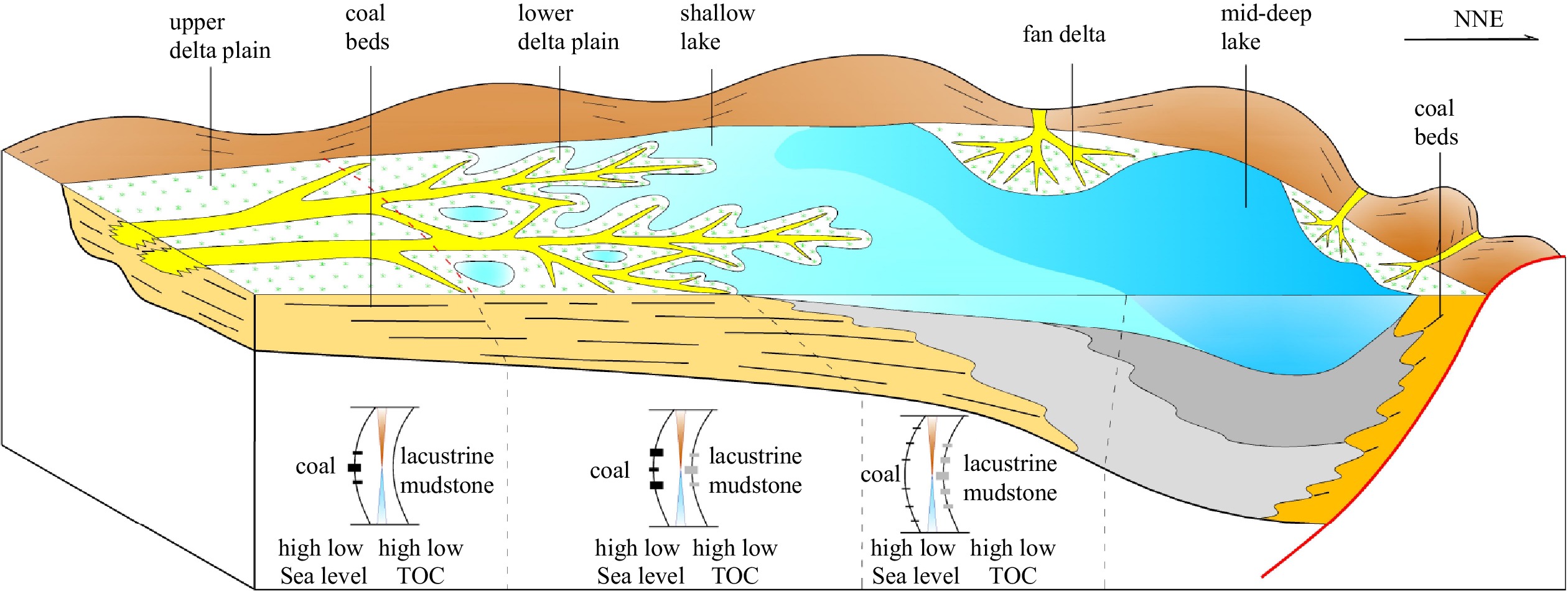
The coal-forming environment of the offshore basins in China differs from that of continental basins. Due to the joint influence of river environment and ocean (tide, waves, etc.), the genesis mechanism, development and distribution of coal-bearing series bear certain uniqueness (Fig. 2). There are three types of coal-forming environments in the sea area of China: delta, fan delta and tidal flat-lagoon (Fig. 3) (Li et al., 2009, 2010, 2016b, 2021a; Yang, 2017; Guo et al., 2006, 2016; Wu et al., 2012; Zhou et al., 2016; Shen, 2018; Zhang et al., 2020; Xiao et al., 2021; Liu et al., 2022).


Deltas are the most important coal-forming environments in China’s sea area. The most typical are the large-scale delta coal accumulations developed in the early Oligoceneof the Zhujiang River Mouth Basin (Li et al., 2016a, 2021a; Zeng et al., 2017, 2019; Zhang et al., 2014b) and the Miocene-Pliocene of the central and southern SCS in the Zengmu Basin (Guo et al., 2006, 2016; Yao et al., 2008) and Brunei Sabah Basin (Ma et al., 2012; Liu et al., 2018). The river carries a large amount of sediment and organic matter to form a nutrient-rich delta, with peat swamps being formed throughout the delta plain, and the transition zone of the upper and lower delta plain is most conducive to coal formation. Palaeo-environments such as distributary channel, interdistributary bay and abandoned river channel, are the main places where coal accumulation is most likely to occur, bearing many thin coal seams and the largest cumulative thickness of coal-bearing series. During the deposition period of the Enping Formation on the northern slope of the Baiyun Sag in the Zhujiang River Mouth Basin, large deltas were widely developed. The key period of coal formation in this area was the period when the Enping Depression was gradually silted and filled. The interdistributary bay and swamp environment developed in the delta plain were the main places for coal accumulation (Fig. 4). During the period of the Enping Formation, the development of continental mountains in the South China, sufficient material supply, flat terrain of the basin and shallow water body led to the continuous development of large-scale delta and wide development range of delta plain and fluvial facies. In the late deposition of the Enping Formation, the strong material supply caused the delta to migrate to the depression center, and the coal accumulation environment also migrated with it, thus expanding the scope of coal accumulation environment. In the late deposition of the Enping Formation, the scale of the delta reached 5 000 km2, and the range of the Enping Formation coal composition gradually expanded from bottom to top.

The tidal flat-lagoon environment with barrier coast is an important coal-forming environment in China’s sea basins; the multi-stage developed tidal flat and the transition place between tidal flat and fan delta and delta are favorable places for coal formation. The coal formation in the tidal flat-lagoon environment of the Pinghu Formation in the Xihu Sag of the East China Sea is the most typical (Wei et al., 2012; Zhou et al., 2016; Yi et al., 2018; Shen, 2018; Liu et al., 2022).
The barrier effect of barrier island or ancient bulge decreases the connectivity of seawater, and the lagoon environment is developed. The tidal flat environment is developed on the outer edge slope of the lagoon, while the inner side of the ancient bulge acts as barrier, and the tidal channel-tidal channel system is also developed. The swamp environment developed in the supratidal zone and the upper part of the intertidal zone of the tidal flat is the main place where coal accumulation occurs (Fig. 5). The development of coal seams in the tidal flat environment is closely related to the tidal channel. In the multi-tidal channel area, the coal-forming conditions are good and the number of coal seams is large, yet the thickness is thin and the coal seam spacing is large. In areas with fewer tidal channels, the number of coal seams is small, but the thickness is larger the coal seam spacing is small, and the coal seam structure is complex (i.e., there are many interlayers in the coal seam). In addition, there is a negative correlation between the scale of tidal channel sand body and the development of the coal seam. The coal seam is well developed between the banded and dendritic tidal channel sand bodies, while being thinner where the tidal channel sand body is relatively developed, thus indicating that the tidal channel water body is active and unblocked, and the coal formation mainly occurs in the low-lying areas between tidal channels. If the coal formation occurs in the abandoned tidal channel, then the thick coal belt along the tidal channel is formed. During the transgression period, the tidal flat environment migrated away from the lagoon, the coal accumulation environment also migrated with it, and the coal accumulation range decreased. During the regression period, the tidal flat environment advanced to the lagoon, and the coal seams also migrated to the lagoon, thereby expanding the scope of the coal accumulation environment. The coal accumulation mainly occurs in the gentle slope zone. Although the steep slope zone also has a tidal flat environment, its facies zone is narrow and the environment changes rapidly, which is not conducive to the occurrence of coal accumulation, but sporadic thin coal seams are present.

The coal-bearing series of the Pinghu Formation in the western slope belt of the Xihu Sag in the East China Sea Basin are delta and tidal flat-lagoon deposits (Zhou et al., 2016; Yi et al., 2018; Shen, 2018; Jiang et al., 2020; Liu et al., 2022) affected by tides. The coal-forming environment underwent many development stages and has a wide distribution area, and the cumulative thickness of coal seams can reach more than 70 m (Fig. 6). The observation of multiple cores in the Pingbei area shows that the gypsum salt rock formed in the evaporation lagoon environment, while the semi bright coal formed in the shallow water swamp. In addition, the sedimentary structures such as the double clay layer in the typical tidal channel sedimentary sandstone and reaction surface of the tidal flat sandstone clearly indicate the characteristics of the tidal flat-lagoon environment. Marine fossils such as calcareous ultramicro and foraminifera were found during the drilling of the Hangzhou Slope, which shows that the deposition period of the Pinghu Formation on the Hangzhou Slope was significantly affected by transgression. The relative content of diterpenes in the coal and mudstone is high, thus indicating that the development area of hydrophilic ferns and conifers is the development area of coal-bearing series.

The coal formation in fan delta environment was mainly developed in the Yacheng and Lingshui Formations during the faulting activity period of the Qiongdongnan Basin. It is distributed in the coastal plain environment and appears in the transition area between ancient uplift and shallow sea. It originated from the alluvial fan into the sea basin to form the fan delta. In the fan delta plain and coastal plain, the terrain is relatively flat, and the vegetation in the ancient uplift and plain area is abundant, which provides conditions for peat accumulation. Although the fan delta is small in scale, it appears in groups and belts. During the Yacheng Formation period of the Qiongdongnan Basin, the basin fault depression structure was controlled by three major fault zones, which respectively developed the coal-bearing fan delta belt on the northern edge of the northern depression at the downthrown side of fault 5, the northern edge of the central depression under faults 3 and 2, and the southern edge of the central depression under the northern slope of the southern uplift belt. In total, there are three small- and medium-sized coal-measure (fan) delta belts (Li et al., 2009, 2010; Zhang et al., 2019).
(1) In the coal-bearing fan delta belt on the northern edge of the northern depression, the drilling of the secondary uplift in the Yabei Sag reveals that the core of the delta plain in the 1st section of the Yacheng Formation is gray-black mudstone, with development of horizontal bedding, containing plant stem and leaf fossils and rich mangrove plant sporopollen. The logging curve is used to comprehensively identify 35 coal seams in the Yacheng Formation, with a cumulative thickness of 16.8 m. The southeastern part of the sag is locally connected with the shallow sea, where tidal flat-lagoon deposits of marine to continental facies are mainly developed. Lagoon deposits are mainly developed in the deep depression, tidal flat deposits are mainly developed in the southern gentle slope zone, and fan deltas are locally developed at the root of the downthrown side of large faults. Finally, the coal seams are mainly developed in the fan delta plain swamp, the supratidal zone and upper part of the intertidal zone and silted swamp environment around the lagoon.
(2) A total of 12 (fan) deltas with an area of 2 240 km2 are developed in the coal accumulation belt on the northern edge of the central depression. The coal seams of the third section of the Yacheng Formation are revealed in the Ya’nan Sag by multiple wells. More than a dozen thin coal seams are revealed in the core of the third member of Yacheng Formation, with small thickness, many layers and poor stability of coal seams; the thickness of coal seams is less than 30 cm and can be as thin as a few centimetre. The coal seam color is dark gray to black with dim luster. They are semi bright-semi dark coals with large coal density, and they are all high-ash and high-sulfur coals, indicating that the coal seams are affected by seawater during the deposition period with strong hydrodynamic force. The middle and lower coal seams are mainly vitrite, thus indicating that the environment is shallow overlying water and bears the characteristics of hypautochthonous coal. There are few exploration wells in the eastern section of the belt, but coal-bearing series are encountered in the Yacheng Formation of Well LS4-2-1 on the northern edge of the Songnan Sag. Coal type gas is seen in the Baodao and Songdong Sags. The underlying Oligocene coal-bearing series are hydrocarbon source rocks, reflecting the fact that coal-bearing series are likely to develop along the Nos 2 and 3 fault zones.
(3) A total of 13 fan deltas with an area of 2 690 km2 are developed in the coal accumulation zone on the southern edge of the central depression. The Beijiao Sag is an environment of barrier coast tidal flat-fan delta transition, which is conducive to the development of coal seams. Drilling revealed 10 coal seams of the Yacheng Formation in this area, with a total of 11.4 m, while the logging comprehensively identified 23 coal seams, with a cumulative thickness of 26.8 m. The favorable coal accumulation environment of the coal accumulation zone is mainly fan delta plain swamp, interdistributary bay, supratidal zone and upper part of the intertidal zone , along with the swamp around the silted and shallowed lagoon and the coastal offshore zone .
(1) China’s sea area has undergone multiple episodes of rifting in the Paleogene, Neogene-Quaternary depression and compression inversion, forming 26 Cenozoic sedimentary basins, which has laid a foundation for the formation of very large coal-bearing basins. The giant coal-bearing basins in China’s sea area include active continental marginal basins, passive continental margin basins, transitional continental marginal basins, and drift rift basins. Coal type source rocks are drilled in these coal-bearing basins, and are generally medium- to high-quality source rocks.
(2) There are 5 coal-forming periods in China’s sea area: Paleocene, Eocene, early Oligocene, late Oligocene and Miocene-Pliocene. These coal-forming periods have formed a total of 14 medium- and large-sized coal type source rock development areas in China’s sea area basins. With the gradual migration of favorable climate belt for coal-forming to the south, the coal-forming environment also continues to migrate southward. As a result, the coal-forming period of the basins in China’s sea area became newer gradually from north to south.
(3) The coal-forming environment of the China’s sea area basins differ from that of continental basins. It is jointly affected by river environment and ocean (tide, waves, etc.), and its genetic mechanism and the development and distribution of coal-bearing series are unique. There are 3 types of sedimentary environments in China’s sea areas: delta, fan delta and tidal flat-lagoon. The coal seams developed in different environments are characterized by thin thickness, many layers and poor stability. The coal-bearing series in China’s sea area are widely distributed, thick and large in volume, providing a rich material basis for the generation of coal type oil and gas.
|
Chen Ping, Wang Ren, Qin Jungan, et al. 2022. Oligocene-miocene palynostratigraphy and paleoclimate of well WN-A from deep water area, southeast Hainan Basin. Journal of Jilin University (Earth Science Edition) (in Chinese), 52(2): 390–402
|
|
Deng Mingfang, Chen Weihuang. 1989. Geologic settings for YA13–1 giant gas field formation. China Offshore Oil and Gas (in Chinese), 3(6): 19–26
|
|
Diessel C F K. 1992. Coal-Bearing Depositional Systems. Berlin: Springer
|
|
Diessel C, Boyd R, Wadsworth J, et al. 2000. On balanced and unbalanced accommodation/peat accumulation ratios in the Cretaceous coals from Gates Formation, western Canada, and their sequence-stratigraphic significance. International Journal of Coal Geology, 43(1–4): 143–186
|
|
Fu Jian. 2019. The study of hydrocarbon generation mechanism of source rocks and origin of oil in the Baiyun Sag, Pearl River Mouth Basin (in Chinese)[dissertation]. Beijing: China University of Petroleum
|
|
Gong Heyan. 2014. Tectonic evolution and its control on coal-measure source rocks in Zhu-3Depression of Pearl River Mouth Basin (in Chinese)[dissertation]. Xuzhou: China University of Mining and Technology
|
|
Guo Jia, Xie Xiaojun, Liu Shixiang, et al. 2016. Cenozoic sedimentary systems in Zengmu Basin, South China Sea. China Petroleum Exploration (in Chinese), 21(4): 99–107
|
|
Guo Xiurong, Wu Qiang, Qiu Yan, et al. 2006. Analysis of the shelf-margin delta in the south of Zengmu Basin, South China Sea. Marine Geology & Quaternary Geology (in Chinese), 26(4): 1–6
|
|
Hu Chaoyuan. 1982. Source bed controls hydrocarbon habitat in continental basins, East China. Acta Petrolei Sinica (in Chinese), 2: 9–13
|
|
Hu Yicheng, Liao Yuzhi, Xu Shiqiu, et al. 1997. Late Carboniferous storm events and their effects on coal accumulation in Southern North China. Earth Science (in Chinese), 22(1): 46–50
|
|
Huang Baojia, Li Xushen, Wang Zhenfeng, et al. 2012. Source rock geochemistry and gas potential in the deep water area, Qiongdongnan Basin. China Offshore Oil and Gas (in Chinese), 24(4): 1–7
|
|
Huang Baojia, Xiao Xianming, Dong Weiliang. 2002. Characteristics of hydrocarbon source rocks and generation & evolution model of natural gas in Yinggehai Basin. Natural Gas Industry (in Chinese), 22(1): 26–30
|
|
Huang Maokai. 1995. Dongfang 1–1 large gas field in the South China Sea has been confirmed. Petroleum Exploration and Development (in Chinese), 22(2): 12
|
|
Jiang Yiming, Shao Longyi, Li Shuai, et al. 2020. Deposition system and stratigraphy of Pinghu Formation in Pinghu tectonic belt, Xihu Sag. Geoscience (in Chinese), 34(1): 141–153
|
|
Lan Lei, Li Youchuan, Wang Yibo. 2021. Two distribution patterns of the marine-continental transitional source rocks in the southern South China Sea. Marine Geology & Quaternary Geology (in Chinese), 41(5): 173–180
|
|
Li Zengxue. 2009. Coal Geology (in Chinese). Beijing: Geology Press
|
|
Li Yan, Deng Yunhua, Li Youchuan, et al. 2016a. Characteristics and favorable facies of coal-measure source rocks in river-delta system of Pearl River Mouth Basin. Journal of Northeast Petroleum University (in Chinese), 40(1): 62–71
|
|
Li Yan, Deng Yunhua, Li Youchuan. 2021a. Characteristics and mechanism of source rock development controlled by sedimentary microfacies in river-delta system: case study of coal-measure source rock in Enping Formation in Pearl River Estuary Basin. Geoscience (in Chinese), 35(4): 1065–1077
|
|
Li Youchuan, Deng Yunhua, Zhang Gongcheng. 2012a. Zoned distribution of source rocks and hydrocarbon offshore China. China Offshore Oil and Gas (in Chinese), 24(1): 6–12
|
|
Li Youchuan, Fu Ning, Zhang Zhihuan. 2013. Hydrocarbon source conditions and origins in the deepwater area in the northern South China Sea. Acta Petrolei Sinica (in Chinese), 34(2): 247–254
|
|
Li Xiaotang, He Jiaxiong, Zhang Wei, et al. 2016b. The synthetic evaluation of Paleogene and Neogene source rocks and the favorable exploration target in Yinggehai Basin. Marine Geology & Quaternary Geology (in Chinese), 36(2): 129–142
|
|
Li Zengxue, Han Meilian, Zhang Gongcheng, et al. 2009. Sedimentological characteristics of the coal seams of Yacheng Formation in Qiongdongnan Basin, China. Energy Exploration & Exploitation, 27(6): 411–424
|
|
Li Zengxue, He Yuping, Liu Haiyan, et al. 2010. Sedimentology characteristics and coal-forming models in Yacheng Formation of Qiongdongnan Basin. Acta Petrolei Sinica (in Chinese), 31(4): 542–547
|
|
Li Zengxue, Lü Dawei, Wang Dongdong, et al. 2015. The multiple coal-forming theoretical system and its model. Acta Geoscientica Sinica (in Chinese), 36(3): 271–282
|
|
Li Zengxue, Wei Jiuchuan, Han Meilian. 2001. Coal formation in transgressive events — a new pattern of coal accumulation. Advance in Earth Sciences (in Chinese), 16(1): 120–124
|
|
Li Xiaotang, Yu Shuyou, He Jiaxiong, et al. 2016c. Paleogene hydrocarbon sources and their petroleum geological significance in Yinggehai Basin, northwestern South China Sea. Marine Geology Frontiers (in Chinese), 32(12): 16–25
|
|
Li Zengxue, Zhang Gongcheng, Li Ying, et al. 2012b. The Paleogene coal-bearing basin and coal-measures distribution of China sea area. Earth Science Frontiers (in Chinese), 19(4): 314–326
|
|
Li Youchuan, Zhao Zhigang, Lan Lei, et al. 2021b. Differential distribution of oil and gas in the Zengmu Basin and the Brunei-Sabah Basin under the joint control of source rock and thermal evolution degree. Natural Gas Industry (in Chinese), 41(11): 24–32
|
|
Liu Yinghui, Cai Hua, Duan Dongping, et al. 2022. The sedimentary characteristics of tidal delta and tidal flat in transgressive system tract of Pinghu Formation in Pinghu area, Xihu Sag. Marine Geology Frontiers (in Chinese), 38(1): 33–40
|
|
Liu Junhai, Wu Zhixuan, Yu Shui, et al. 2005. Paleocence trace element geochemistry and its geological significance in Lishui sag. China Offshore Oil and Gas (in Chinese), 17(1): 8–11
|
|
Liu Shixiang, Zhao Zhigang, Xie Xiaojun, et al. 2018. Petroleum geology and exploration prospects of Wenlai-Shaba Basin. Science Technology and Engineering (in Chinese), 18(4): 29–34
|
|
Ma Liangtao, Wang Chunxiu, Niu Jiayu, et al. 2012. Hydrocarbon geology in NW Sabah Basin and controlling factors on hydrocarbon accumulation. Marine Geology Frontiers (in Chinese), 28(7): 36–43
|
|
Mi Lijun, Zhang Zhongtao, Pang Xiong, et al. 2018. Main controlling factors of hydrocarbon accumulation in Baiyun Sag at northern continental margin of South China Sea. Petroleum Exploration and Development (in Chinese), 45(5): 902–913
|
|
Petroleum Geology Compilation Group. 1990. Petroleum Geology of China: Coastal Continental Shelf and Adjacent Offshore Oil and Gas Areas (in Chinese). Beijing: Petroleum Industry Press
|
|
Qian Menhui, Hou Dujie, Jiang Qigui, et al. 2012. Features and geologic significance of maceral composition of coal-bearing source rocks in Xihu Sag. Petroleum Geology & Experiment (in Chinese), 34(2): 182–185
|
|
Qin Jungan, Wu Guoxuan, Li Jun, et al. 2016. Spores, pollen, freshwater algae and dinoflagellate cysts recorded in the Oligocene—Pliocene from the southeast Hainan Basin, South China Sea. Acta Micropalaeontologica Sinica (in Chinese), 33(4): 335–349
|
|
Sang Shuxun, Chen Shiyue, Liu Huanjie. 2001. Study on diversity of Late Paleozoic coal-forming environments and models in North China. Chinese Journal of Geology (in Chinese), 36(2): 212–221
|
|
Shao Longyi, Chen Jialiang, Li Ruijun, et al. 2003. A sequence stratigraphic interpretation on Late Permian carbonate coal measures in the Heshan coal field, Southern China. Acta Sedimentologica Sinica (in Chinese), 21(1): 168–174
|
|
Shao Longyi, Zhang Pengfei, Liu Qinfu, et al. 1992. The Lower Carboniferous Ceshui Formation in central Hunan, South China: depositional sequences and episodic coal accumulation. Geological Review (in Chinese), 38(1): 52–59
|
|
Shen Wenchao. 2018. The coal accumulation model and sedimentary organic facies of Paleogene coal in the Xihu Depression (in Chinese)[dissertation]. Beijing: China University of Mining & Technology, Beijing
|
|
Shen Wenlong, Qi Binwen, Xu Guangchen, et al. 2019. The seismic inversion based organic matter abundance prediction method for source rocks and its application in Lishui Sag. China Offshore Oil and Gas (in Chinese), 31(3): 68–74
|
|
Shen Wenlong, Qi Binwen. 2020. Definition and distribution prediction of effective source rocks in Lishui Sag, East China Sea Basin. Bulletin of Geological Science and Technology (in Chinese), 39(3): 77–88
|
|
Shen Yulin, Qin Yong, Cui Min, et al. 2021. Geochemical characteristics and sedimentary control of Pinghu Formation (Eocene) coal-bearing source rocks in Xihu Depression, East China Sea Basin. Acta Geologica Sinica (English edition), 95(1): 91–104. doi: 10.1111/1755-6724.14624
|
|
Shen Wenchao, Shao Longyi, Zhou Qianyu, et al. 2022. Geochemistry of argillaceous rocks of the Eocene Pinghu Formation from Xihu depression in East China Sea Basin and its geological significance. Acta Geologica Sinica (in Chinese), 96(6): 2078–2093
|
|
Shi Hesheng, Liu Baojun, Yan Chengzhi, et al. 2010. Hydrocarbon accumulation conditions and exploration potential in Baiyun-Liwan deepwater area, Pearl River Mouth Basin. China Offshore Oil and Gas (in Chinese), 22(6): 369–374
|
|
Sun Jinshan, Liu Xin, Du Kezheng, et al. 2013. Cases of discovery and exploration of marine fields in China, part 14: Liuhua 16-2 light oil field in Pearl River Mouth Basin, northern South China Sea. Marine Origin Petroleum Geology (in Chinese), 18(1): 71–78
|
|
Tang Wu, Zhao Zhigang, Song Shuang, et al. 2021. Differences in the tectonic evolution of basins in the central-southern South China Sea and their hydrocarbon accumulation conditions. Acta Geologica Sinica (English edition), 95(1): 30–40. doi: 10.1111/1755-6724.14638
|
|
Tian Zhiwen, Tang Wu, Wang Pujun, et al. 2021. Tectonic evolution and key geological issues of the proto-South China Sea. Acta Geologica Sinica (English edition), 95(1): 77–90. doi: 10.1111/1755-6724.14644
|
|
Wang Dongdong, Dong Guoqi, Zhang Gongcheng, et al. 2020. Coal seam development characteristics and distribution predictions in marginal sea basins: Oligocene Yacheng Formation coal measures, Qiongdongnan Basin, northern region of the South China Sea. Australian Journal of Earth Sciences, 67(3): 393–409. doi: 10.1080/08120099.2019.1661286
|
|
Wang Zhenfeng, Sun Zhipeng, Zhu Jitian, et al. 2015. Natural gas geological characteristics and great discovery of large gas fields in deep water area of the western South China Sea. Natural Gas Industry (in Chinese), 35(10): 11–20
|
|
Wang Deng, Xu Yaohui, Wen Zhigang. 2013. et al. Evaluation of source rocks and oil-source correlation in east Balingian Depression of Zengmu Basin. Bulletin of Mineralogy, Petrology and Geochemistry (in Chinese), 32(5): 583–590
|
|
Wang Dongdong, Zhang Gongcheng, Li Zengxue, et al. 2021. The development characteristics and distribution predictions of the Paleogene coal-measure source rock in the Qiongdongnan Basin, northern South China Sea. Acta Geologica Sinica (English edition), 95(1): 105–120. doi: 10.1111/1755-6724.14625
|
|
Wei Hengfei, Chen Jianfa, Zhang Tonglei, et al. 2012. Sequence stratigraphic division and concentrating coal characteristics of Huagang Formation in Xihu depression. Journal of China Coal Society (in Chinese), 37(S1): 149–156
|
|
Wu Jiaoqi, Gao Hongfang, Sun Guihua. 2012. Geological structure and sedimentary systems of the Wan’an Basin, Nansha waters. Marine Geology & Quaternary Geology (in Chinese), 32(5): 1–11
|
|
Xiao Hongyi, He Yunlong, Xie Xinong, et al. 2021. Characteristics of structural-sequence and evolution of tectonic and sedimentary of Wan’an Basin in South China Sea. Earth Science (in Chinese), 46(9): 3338–3351
|
|
Xie Xiaojun, Zhang Gongcheng, Zhao Zhigang, et al. 2015. Hydrocarbon geology, distribution and favorable exploration direction in Zengmu Basin, South China Sea. China Offshore Oil and Gas (in Chinese), 27(1): 19–26
|
|
Xu Bo, Hu Biyao, Gu Zhipeng, et al. 2021a. Geochemical characteristics of trace elements and rare earth elements of Pinghu Formation in Pinghu slope belt of Xihu Sag and their geological significance. Journal of Xi’an Shiyou University (Natural Science Edition) (in Chinese), 36(2): 28–37,49
|
|
Xu Bo, Zeng Wenqian, Diao Hui, et al. 2021b. Trace rare earth elements in the Pinghu Formation of Xihu Sag and its implications for paleo-production environment. Marine Geology & Quaternary Geology (in Chinese), 41(3): 72–84
|
|
Yang Chupeng, Yao Yongjian, Li Xuejie, et al. 2010. Oil-generating potential of Cenozoic coal-measure source rocks in Zengmu Baisn, the southern South China Sea. Acta Petrolei Sinica (in Chinese), 31(6): 920–926
|
|
Yang Liu. 2017. Cenozoic coal accumulation regularity and controlling pattern in China offshore (in Chinese)[dissertation]. Xuzhou: China University of Mining and Technology
|
|
Yao Yongjian, Wu Nengyou, Xia Bin, et al. 2008. Petroleum geology of the Zengmu Basin in the southern South China Sea. Geology in China (in Chinese), 35(3): 503–513
|
|
Yi Qi, Shao Longyi, Qin Lanzhi, et al. 2018. Sedimentary environment and coal accumulation law of Huagang Formation in Pinghu Structural Zone of Xihu Depression. Coal Science and Technology (in Chinese), 46(2): 73–83
|
|
Yin Shiyan, He Sheng, Lei Chuang, et al. 2014. Characteristics and hydrocarbon generation-expulsion history of Yueguifeng Formation source rock in Lishui-Jiaojiang depression, East China Sea shelf basin. Marine Geology Frontiers (in Chinese), 30(8): 35–41,65
|
|
Zeng Zhiwei, Yang Xianghua, Zhu Hongtao, et al. 2017. Development characteristics and significance of large delta of Upper Enping Formation, Baiyun Sag. Earth Science (in Chinese), 42(1): 78–92
|
|
Zeng Zhiwei, Zhu Hongtao, Yang Xianghua, et al. 2019. Using seismic geomorphology and detrital zircon geochronology to constrain provenance evolution and its response of Paleogene Enping Formation in the Baiyun Sag, Pearl River Mouth Basin, South China Sea: implications for paleo-Pearl River drainage evolution. Journal of Petroleum Science and Engineering, 177: 663–680. doi: 10.1016/j.petrol.2019.02.051
|
|
Zhang Gongcheng. 2020. Petroleum Geology in Deepwater Settings of Marginal Sea (in Chinese). Qingdao: China University of Petroleum Press
|
|
Zhang Shudi. 2021. Reconstruction of palaeovegetation and palaeoenvironment community of Pinghu Formation in Xihu Sag by geochemical method (in Chinese)[dissertation]. Beijing: China University of Geosciences, Beijing
|
|
Zhang Gongcheng, Feng Congjun, Yao Xingzong, et al. 2021a. Petroleum geology in deepwater settings in a passive continental margin of a marginal sea: a case study from the South China Sea. Acta Geologica Sinica (English edition), 95(1): 1–20. doi: 10.1111/1755-6724.14621
|
|
Zhang Gongcheng, He Yuping, Shen Huailei. 2012. Distribution of Yacheng Formation coal measure in Yabei Sag in Qiongdongnan Basin. Natural Gas Geoscience (in Chinese), 23(4): 654–661
|
|
Zhang Houhe, He Shuanzhu, Liu Peng, et al. 2017a. Evaluation of source rocks and oil-source correlation of Zengmu Basin. Bulletin of Mineralogy, Petrology and Geochemistry (in Chinese), 36(3): 466–475
|
|
Zhang Houhe, He Shuanzhu, Liu Peng, et al. 2017b. New understanding of oil and gas geological characteristics and resource potential in Wan’an Basin. Petroleum Geology & Experiment (in Chinese), 39(5): 625–632
|
|
Zhang Gongcheng, Jia Qingjun, Wang Wanyin, et al. 2018a. On tectonic framework and evolution of the South China Sea. Chinese Journal of Geophysics (in Chinese), 61(10): 4194–4215
|
|
Zhang Gongcheng, Li Zengxue, He Yuping, et al. 2010. Coal geochemistry of Qiongdongnan Basin. Natural Gas Geoscience (in Chinese), 21(5): 693–699
|
|
Zhang Gongcheng, Li Zengxue, Wang Dongdong, et al. 2020. Characteristics of coal geology in South China Sea. Journal of China Coal Society (in Chinese), 45(11): 3864–3878
|
|
Zhang Houhe, Liao Zongbao, Wang Deng, et al. 2016a. The hydrocarbon generation history and geochemical characteristics of source rocks of middle Miocene in northern inboard belt structural area of Brunei-Sabah Basin. Journal of Yangtze University (Natural Science Edition) (in Chinese), 13(14): 9–15
|
|
Zhang Houhou, Liu Peng, Liao Zongquan, et al. 2017c. Distribution and hydrocarbon geological characteristics of large and medium fields in Nansha Sea Area. Offshore Oil (in Chinese), 37(4): 1–7,20
|
|
Zhang Qiang, Lü Fuliang, He Xiaosu, et al. 2018b. Progress and enlightenment of oil and gas exploration in the South China Sea in recent five years. China Petroleum Exploration (in Chinese), 23(1): 54–61
|
|
Zhang Gongcheng, Qu Hongjun, Liu Shixiang, et al. 2015a. Tectonic cycle of marginal sea controlled the hydrocarbon accumulation in deep-water areas of South China Sea. Acta Petrolei Sinica (in Chinese), 36(5): 533–545
|
|
Zhang Gongcheng, Wang Dongdong, Lan Lei, et al. 2021b. Geological characteristics of the large- and medium-sized gas fields in the South China sea. Acta Oceanologica Sinica, 40(2): 1–12. doi: 10.1007/s13131-021-1754-x
|
|
Zhang Gongcheng, Wang Dongdong, Zeng Qingbo, et al. 2019. Characteristics of coal-measure source rock and gas accumulation belts in marine-continental transitional facies fault basins: a case study of the Oligocene deposits in the Qiongdongnan Basin located in the northern region of the South China Sea. Energy Exploration & Exploitation, 37(6): 1752–1778
|
|
Zhang Gongcheng, Wang Pujun, Wu Jingfu, et al. 2015b. Tectonic cycle of marginal oceanic basin: a new evolution model of the South China Sea. Earth Science Frontiers (in Chinese), 22(3): 27–37
|
|
Zhang Gongcheng, Wang Qi, Miao Shunde, et al. 2014a. The duality distribution pattern of marine-continental transitional hydrocarbon source rocks: a case study from Baiyun Sag in Pearl river Mouth Basin, China offshore. Natural Gas Geoscience (in Chinese), 25(9): 1299–1308
|
|
Zhang Gongcheng, Yang Haizhang, Chen Ying, et al. 2014b. The Baiyun Sag: a giant rich gas-generation sag in the deepwater area of the Pearl River Mouth Basin. Natural Gas Industry (in Chinese), 34(11): 11–25
|
|
Zhang Gongcheng, Zeng Qingbo, Su Long, et al. 2016b. Accumulation mechanism of LS 17-2 deep water giant gas field in Qiongdongnan Basin. Acta Petrolei Sinica (in Chinese), 37(S1): 34–46
|
|
Zhang Yifan, Liu Dongsheng, Zhang Xunhua. 2017d. Neogene palynological assemblages from Qiongdongnan Basin and their paleoclimatic implications. Marine Geology & Quaternary Geology (in Chinese), 37(1): 93–101
|
|
Zhao Honggang, Li Ying, Chang Xiangchun, et al. 2021a. A comparative study of the coal-forming characteristics of marginal sea basins and epicontinental sea basins. Acta Geologica Sinica (English edition), 95(1): 121–130. doi: 10.1111/1755-6724.14630
|
|
Zhao Zhigang, Liu Shixiang, Xie Xiaojun, et al. 2016. Hydrocarbon geological characteristics and reservoir forming conditions in Wan’an Basin, South China Sea. China Offshore Oil and Gas (in Chinese), 28(4): 9–15
|
|
Zhao Zhigang, Zhang Hao, Cui Yuchi, et al. 2021b. Cenozoic sea-land transition and its petroleum geological significance in the northern South China Sea. Acta Geologica Sinica (English edition), 95(1): 41–54. doi: 10.1111/1755-6724.14628
|
|
Zheng Tao, Wang Deng, Zhou Shiqing, et al. 2014. Geological characteristics of source rocks from middle-Later Miocene in southwestern margin of Brunei areas of Brunei-Sabah Basin. Journal of Oil and Gas Technology (in Chinese), 36(5): 20–24
|
|
Zhou Qianyu, Shen Wenchao, Zhang Xin, et al. 2016. The coal-accumulating environments characteristics and coal-forming pattern of Pinghu Formation (Paleogene) in Xihu Depression. Journal of Hebei University of Engineering (Natural Science Edition) (in Chinese), 33(1): 105–107,112
|
|
Zhu Ming, Zhang Xiangtao, Huang Yuping, et al. 2019. Source rock characteristics and resource potential in Pearl River Mouth Basin. Acta Petrolei Sinica (in Chinese), 40(S1): 53–68
|
|
Zhu Yangming, Zhou Jie, Gu Shengxiao, et al. 2012. Molecular geochemistry of Eocene Pinghu Formation coal-bearing source rocks in the Xihu Depression, East China Sea shelf basin. Acta Petrolei Sinica (in Chinese), 33(1): 32–39
|


Figures(6) / Tables(1)

Supported by:
Beijing Renhe Information Technology Co. Ltd

Gongcheng Zhang, Ying Chen, Dongdong Wang, Zengxue Li. Cenozoic giant coal-bearing basin belt discovered in China’s sea area[J]. Acta Oceanologica Sinica, 2023, 42(3): 101-112. doi: 10.1007/s13131-022-2134-x

| Content period | Paleocene | Eocene | Early Oligocene | Late Oligocene | Miocene‒Pliocene |
| Typical basin | East China Sea Basin, Taixi Basin | Xihu Depression Nansha drift basin | Zhujiang River Mouth Basin Qiongdongnan Basin, | Wan’an Basin, Zengmu Basin | Yinggehai Basin, Zengmu Basin, Brunei-Sabah Basin |
| Coal-bearing strata | Lingfeng Fm., Mingyuefeng Fm., Mushan Fm., Daliao Fm., Shidi Fm., Nangang Fm., Nanzhuang Fm. | Pinghu Fm. Nanwei Group | Enping Fm., Yacheng Fm. | Xiwei Group Zengmu Fm. | Lidi Fm. Stage IVA |
| Paleoclimate | temperate climate, early dry heat, late warm humid‒dry heat‒warm humid alternating | subtropical climate, warm, vertical with warm wet‒dry heat‒warm wet alternating | subtropical climate, hot and humid | tropical climate, hot and humid with gradual cooling | subtropical climate, hot and humid |
| Paleobotany | terrestrial higher plants dominated | terrestrial higher plants dominated; temperate type, wet‒hot type plants mixed | mainly subtropical evergreen deciduous broad-leaved forest | higher plants dominated by mangroves | higher plants dominated by mangroves |
| Paleostructure | continental margin rifting stage, fault basins developed, with the strongest rifting in the South Yellow Sea and the western East China Sea | rifting was strengthened, and the fault depression developed very well, forming the Pinghu fault depression in the East China Sea | Enping fault depression was formed in the north of Zhujiang River Mouth Basin, uplift and denudation in the west sag of the Donghai Basin, and subsidence in the east formed continental fault depression | new South China Sea began to expand and the Paleo South China Sea began to shrink | Yellow Sea and East China Sea entered a period of regional subsidence, the expansion of the new South China Sea reached its peak, and the ancient South China Sea continued to shrink |
| Paleogeography | marine facies, marine-continental transition facies | marine facies, marine-continental transition facies | marine-continental transition facies, Marine facies | marine facies, marine-continental transition facies, continental facies | marine facies, marine-continental transition facies |
| Favorable coal-forming zone | delta plain, coastal plain | coastal plain, tidal flat swamp, lagoon siltation swamp | coastal swamp, river-lake swamp | delta plain, bay, tidal flat swamp | coastal plain, delta plain |
DownLoad:
CSV
 DownLoad:

 DownLoad: