

The environmental analysis and site selection of mussel and large yellow croaker aquaculture areas based on high resolution remote sensing
-
Abstract: Mussel aquaculture and large yellow croaker aquaculture areas and their environmental characteristics in Zhoushan were analyzed using satellite data and in-situ surveys. A new two-step remote sensing method was proposed and applied to determine the basic environmental characteristics of the best mussel and large yellow croaker aquaculture areas. This methodology includes the first step of extraction of the location distribution and the second step of the extraction of internal environmental factors. The fishery ranching index (FRI1, FRI2) was established to extract the mussel and the large yellow croaker aquaculture area in Zhoushan, using Gaofen-1 (GF-1) and Gaofen-6 (GF-6) satellite data with a special resolution of 2 m. In the second step, the environmental factors such as sea surface temperature (SST), chlorophyll a (Chl-a) concentration, current and tide, suspended sediment concentration (SSC) in mussel aquaculture area and large yellow croaker aquaculture area were extracted and analyzed in detail. The results show the following three points. (1) For the extraction of the mussel aquaculture area, FRI1 and FRI2 are complementary, and the combination of FRI1 and FRI2 is suitable to extract the mussel aquaculture area. As for the large yellow croaker aquaculture area extraction, FRI2 is suitable. (2) Mussel aquaculture and the large yellow croaker aquaculture area in Zhoushan are mainly located on the side near the islands that are away from the eastern open waters. The water environment factor template suitable for mussel and large yellow croaker aquaculture was determined. (3) This two-step remote sensing method can be used for the preliminary screening of potential site selection for the mussels and large yellow croaker aquaculture area in the future. the fishery ranching index (FRI1, FRI2) in this paper can be applied to extract the mussel and large yellow croaker aquaculture areas in coastal waters around the world.
-
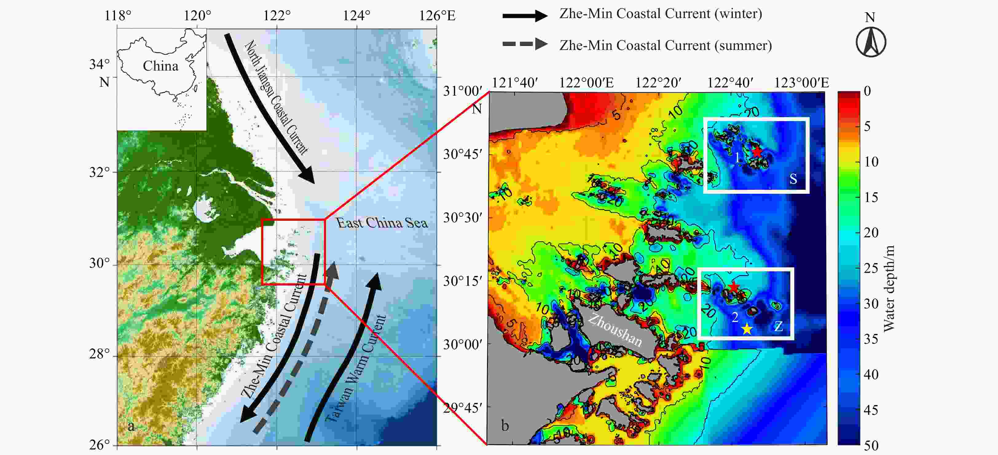
Figure 1. The location of Zhoushan Islands. Point 1: Zhoushan Gouqi Island. S: Zhoushan Ma’an Archipelago sea area. Point 2: Zhoushan Qingbang Island. Z: Zhongjieshan Archipelago sea area of Dongji Town. The red marks are the locations of the two national aquaculture demonstration zones in Zhoushan. The yellow mark is the sampling point of in-situ current data. The map on the top left downloaded from
http://211.159.153.75/ , with figure number of GS(2023)2764.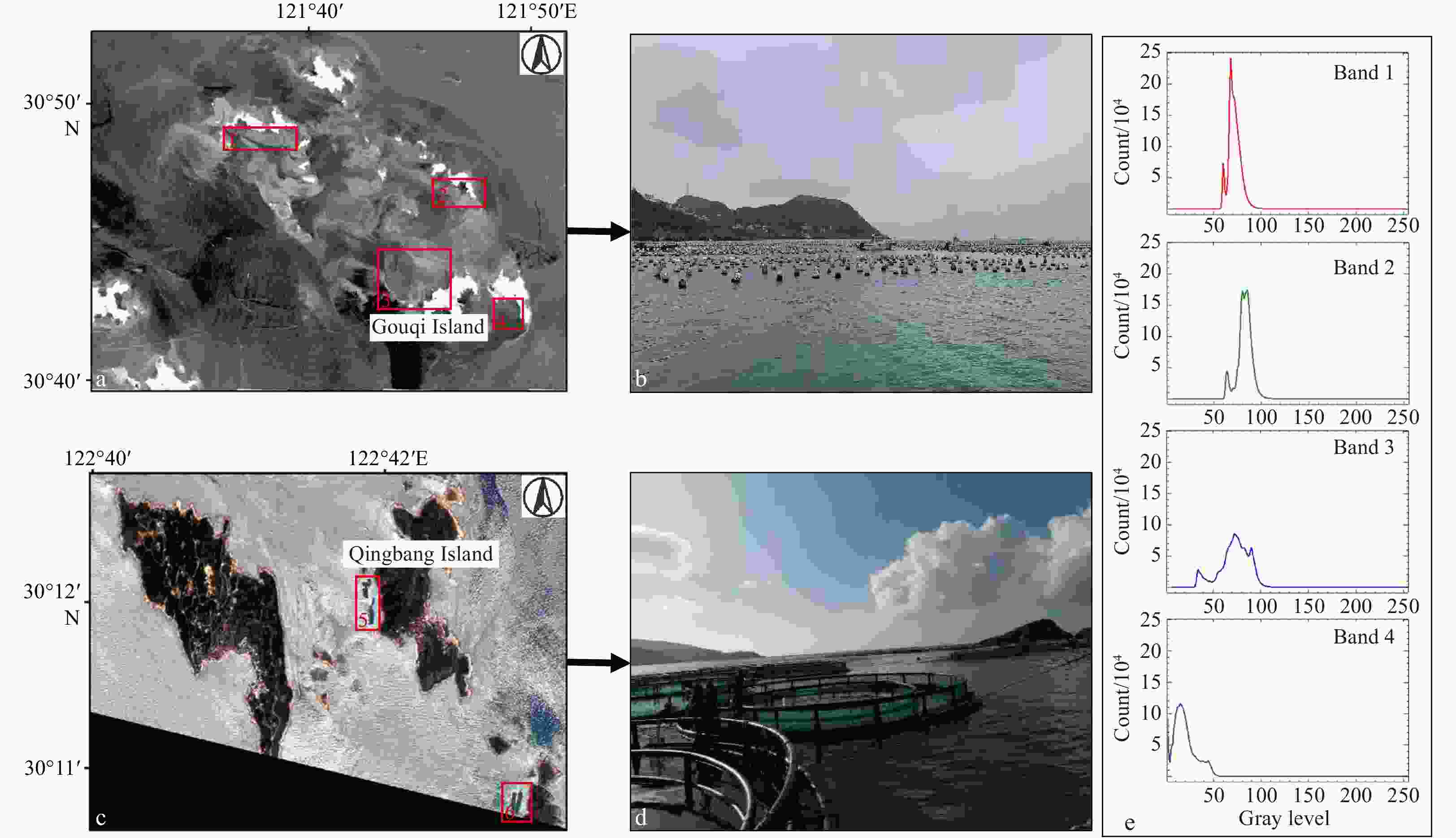
Figure 2. Location of Zhoushan aquaculture area (a and c), a photograph of the mussel aquaculture area in Shengsi, Zhoushan (b), a photograph of large yellow croaker cages near Qingbang Island in Zhoushan (d), and histogram of GF-6 images (March 3, 2019) in 4 bands (e). Four red squares (1, 2, 3, 4) in a: Zhoushan mussel aquaculture area in Shengsi. Two red squares (5, 6) in c: Qingbang Island large yellow croaker aquaculture area in Zhoushan.
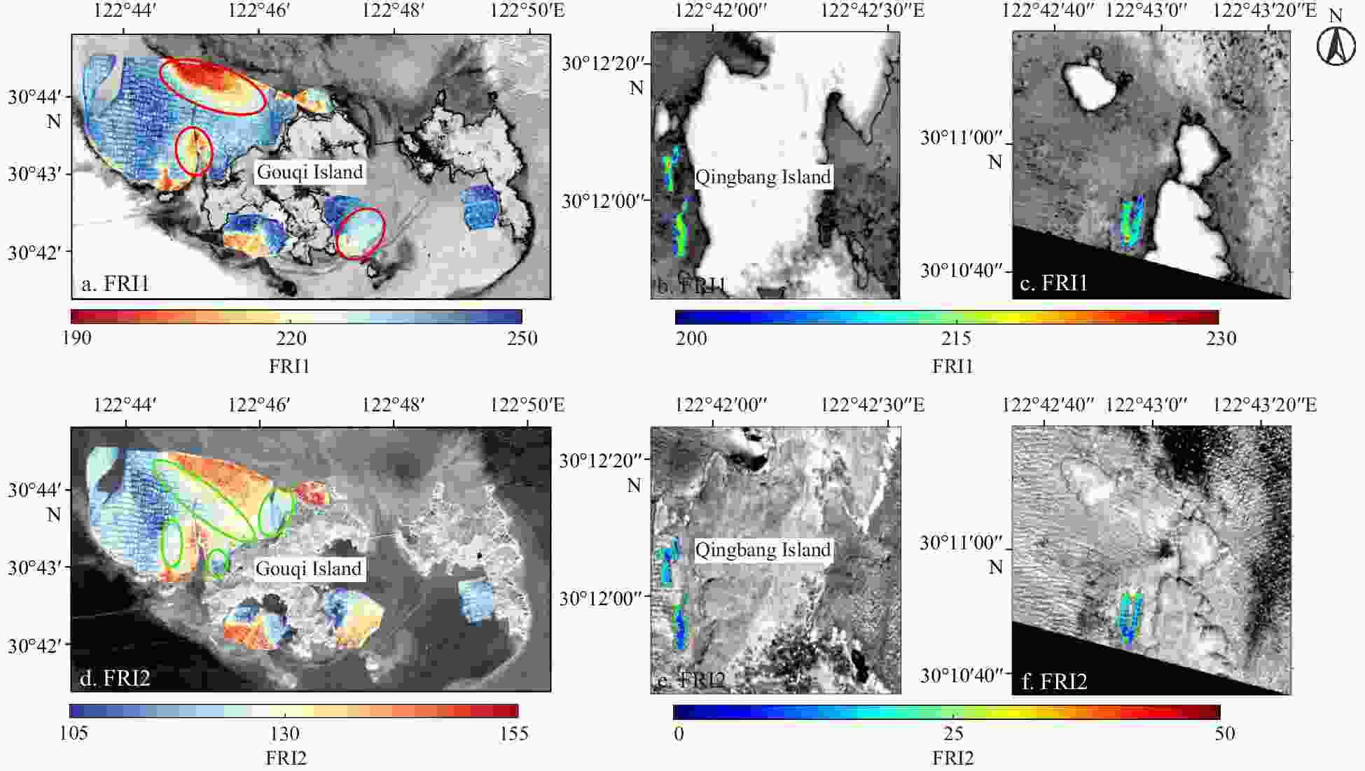
Figure 4. Aquaculture area extracted using FRI1 (a, b, and c) and FRI2 (d, e, and f). The colorful parts in the image highlight the aquaculture area. Images in a and d are from GF-6 satelite data on October 3, 2019. Images in b, c, e, and f are from GF-6 satelite data on August 22, 2020. The colored parts in a and d are the main mussel aquaculture areas around Gouqi Island, and b, c, e, and f are large yellow croaker aquaculture areas around Dongji Qingbang Island.
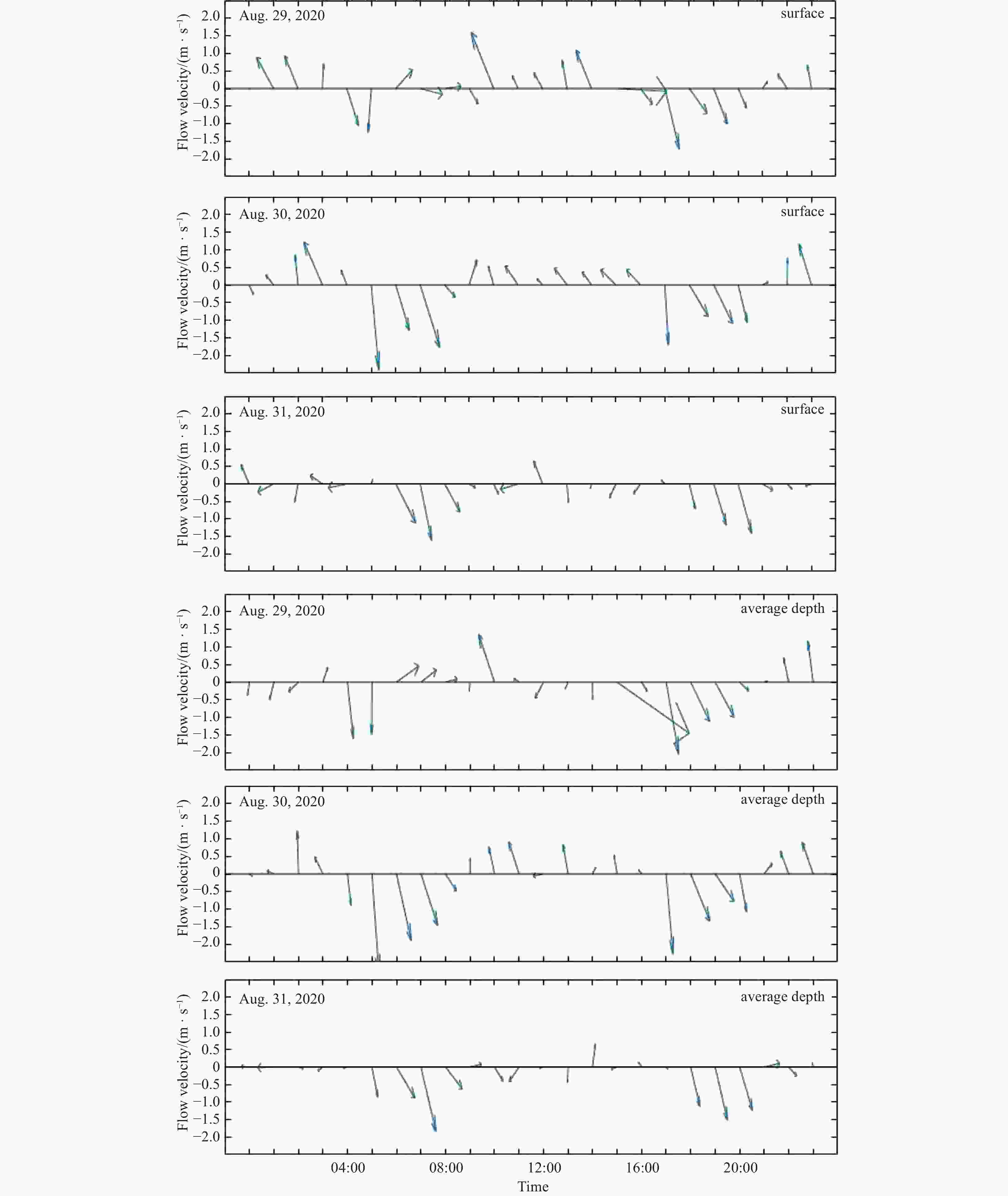
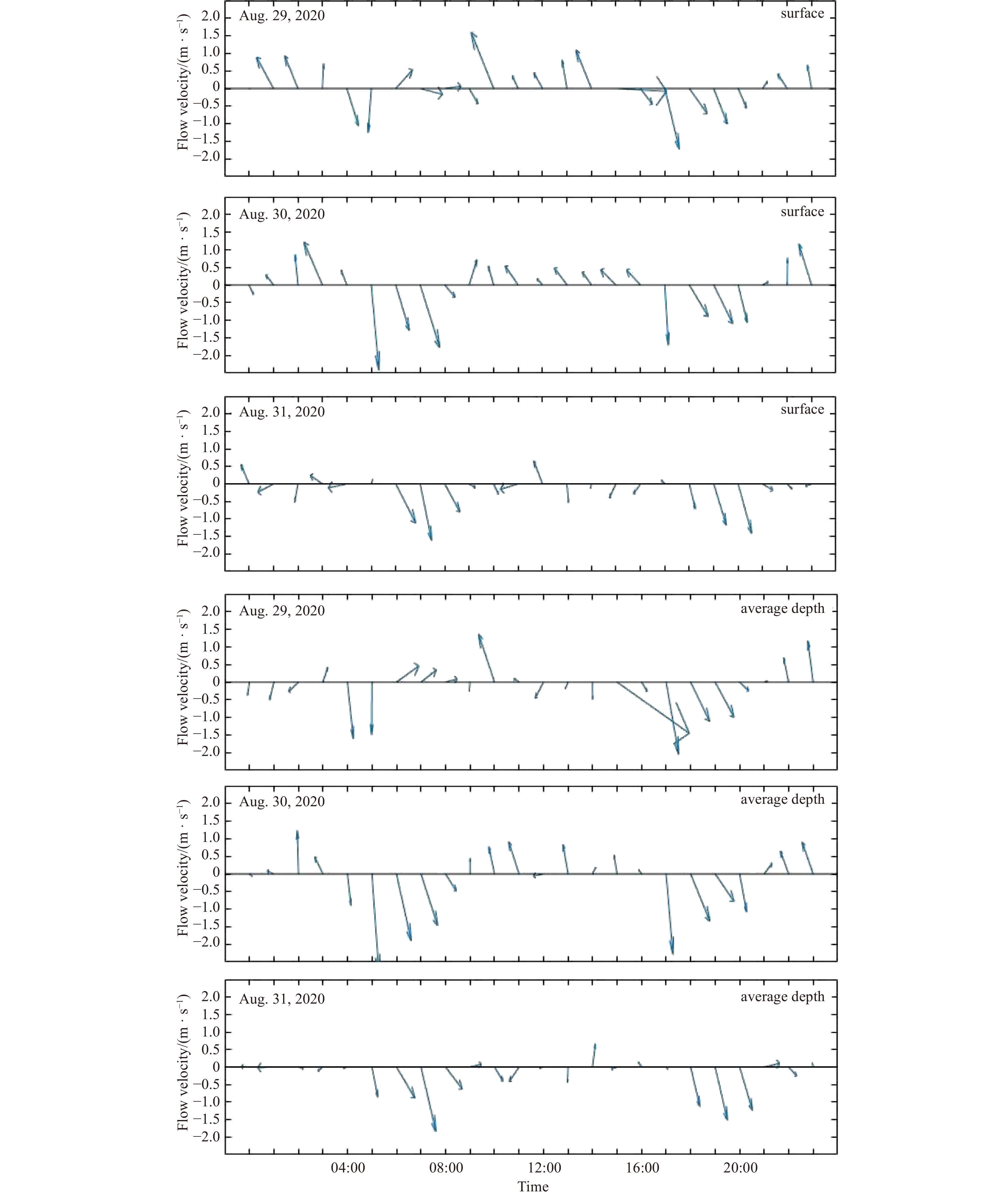
Figure 5. Flow velocity and direction at surface and bottom during August 29 to August 31, 2020.
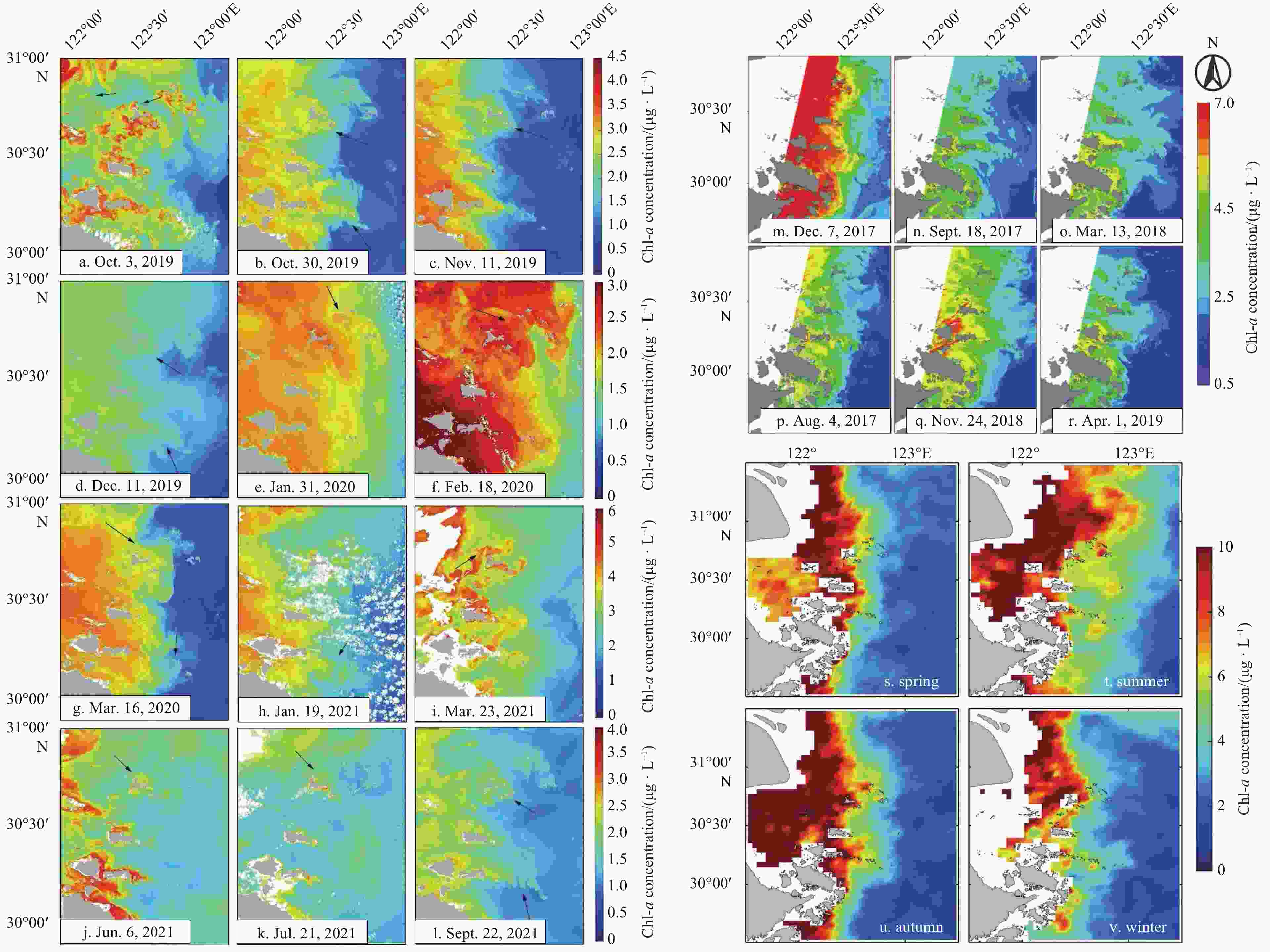
Figure 8. Chl-a concentration distribution retrieved from HY-1C CZI images (a–l), Chl-a concentration distribution retrieved from Landsat8 images (m–r), and average Chl-a concentration distribution map from 2017 to 2020 (s–v). The black arrow indicates the direction of the local tidal current.
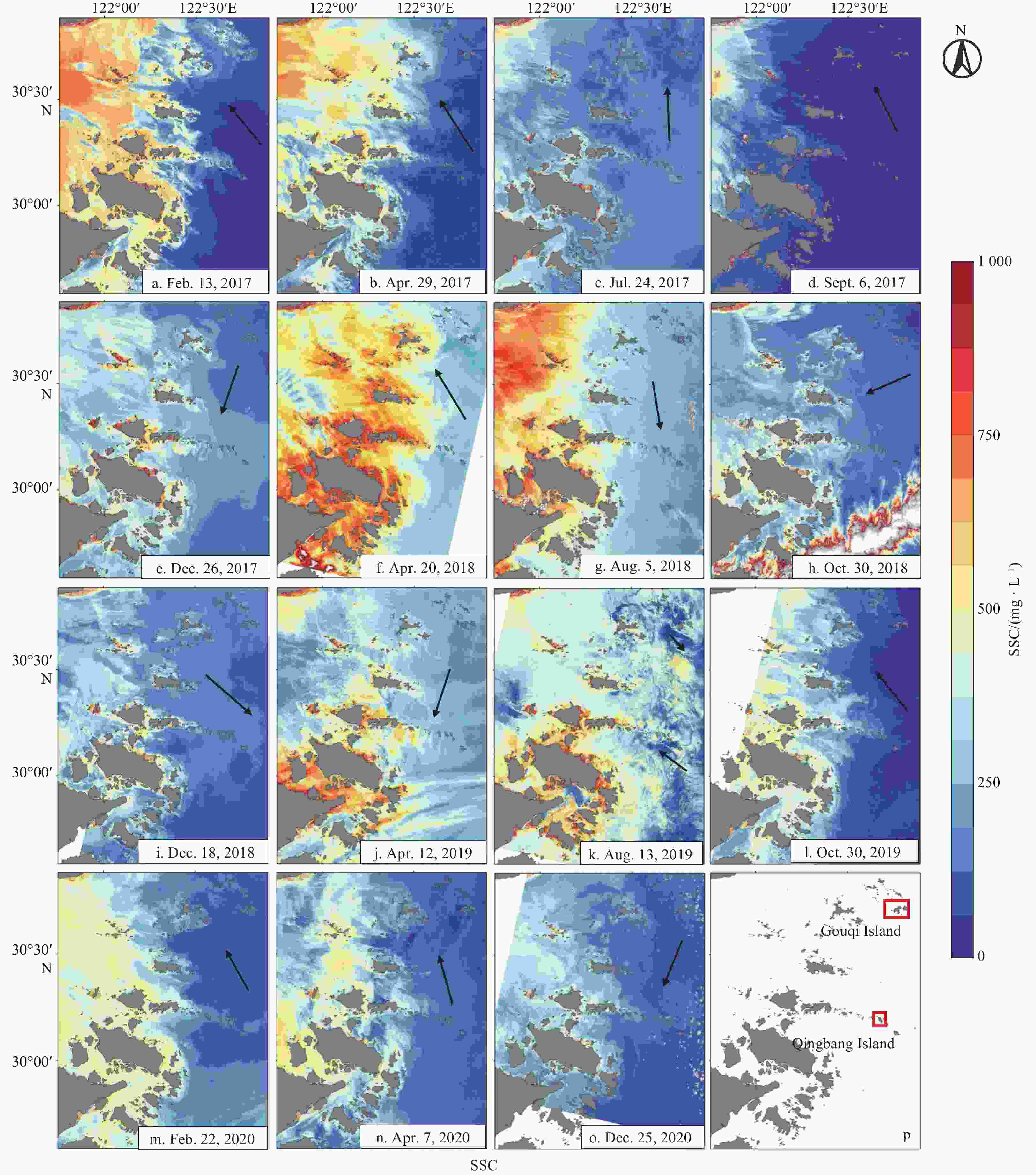
Figure 9. SSC distribution in aquaculture area obtained from GF-1 wide field-of-view satellite images (a–o) and the study areas (p, red boxes). The black arrow indicates the direction of the tidal current.

Figure 10. The distribution of SST, SSS, and wind field. a b, c, and d were obtained from Group for High-Resolution SST (GHRSST) 2021 monthly mean SST data. e, f, g, and h were obtained from the 2021 SSS data provided by Copernicus Marine Environment Monitoring Service (CMEMS). i, j, k, and l were obtained from the 2021 monthly average wind field data provided by Pacific Islands Ocean Observing System (PacIOOS).
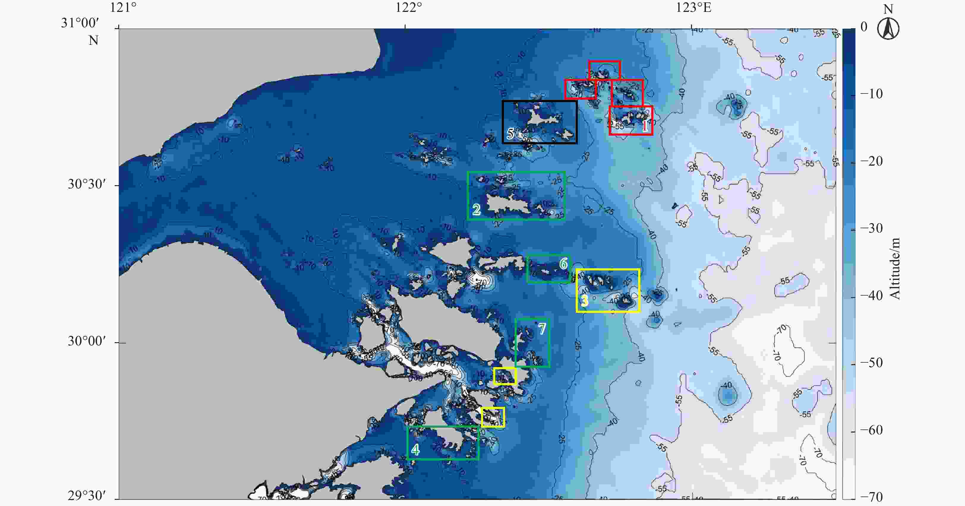
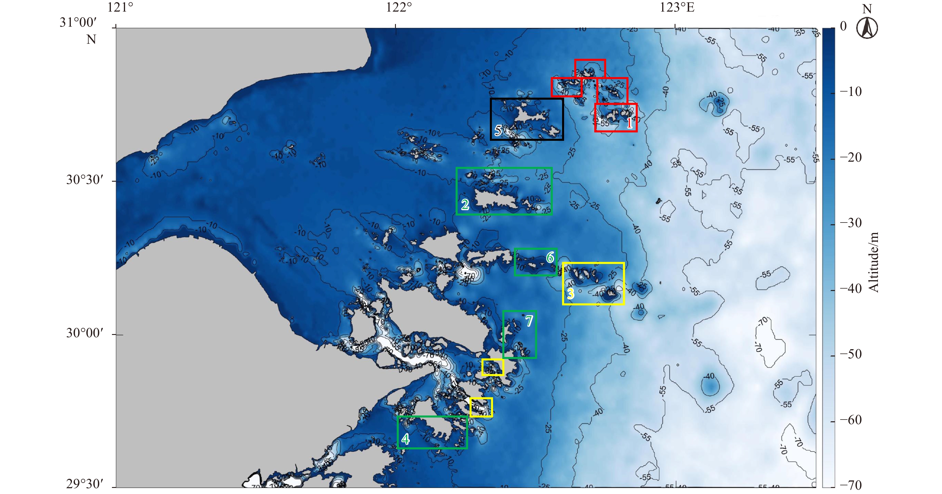
Figure 11. Zhoushan mariculture area and potential mariculture area. The areas in the red boxes are mussel aquaculture area, the areas in the yellow boxes are large yellow croaker aquaculture area, the area in the black box is potential mussel aquaculture area and the areas in the green boxes are potential large yellow croaker aquaculture area. Areas 1, 2, 3, and 4 are the typical regions of the two aquaculture areas. Area 1: Gouqi Island area. Area 2: Qushan Islands area. Area 3: Qingbang Island area. Area 4: Liuheng Island area. Area 5: Shengsi Islands area. Area 6: Daxizhai Island area. Area 7: Putuo Mountain Island area.

Figure 13. Two-step remote sensing method and mechanism for potential site selection for the mussels and large yellow croaker aquaculture area.
Table 1. GF-1 satellite payload parameters
Sensor Band No. Spectral range/μm Spatial resolution/m PMS 1 0.45–0.90 2 PMS 2 0.45–0.52 8 PMS 3 0.52–0.59 8 PMS 4 0.63–0.69 8 PMS 5 0.77–0.89 8 WFV 1 0.45–0.52 16 WFV 2 0.52–0.59 16 WFV 3 0.63–0.69 16 WFV 4 0.77–0.89 16  下载: 导出CSV
Table 2. GF-6 satellite payload parameter
Sensor Band No. Spectral range/μm Spatial resolution/m Width/km PMS 1 (Pan) 0.45–0.90 2 >90 PMS 2 (blue) 0.45–0.52 8 >90 PMS 3 (green) 0.52–0.59 8 >90 PMS 4 (red) 0.63–0.69 8 >90 PMS 5 (NIR) 0.77–0.89 8 >90 Note: Pan, panchromatic; NIR, near infrared.
下载: 导出CSV
Table 3. HY-1C Satellite payload parameters
Sensor Band No. Spectral range/μm Spatial resolution/m CZI 1 0.42–0.50 50 CZI 2 0.52–0.60 50 CZI 3 0.61–0.69 50 CZI 4 0.76–0.89 50
下载: 导出CSV
Table 4. Landsat-8 Satellite payload parameters
Sensor Band No. Spectral range/μm Spatial resolution/m OIL 1 0.49–0.45 30 OIL 2 0.45–0.51 30 OIL 3 0.53–0.59 30 OIL 4 0.64–0.67 30 OIL 5 0.85–0.88 30 OIL 6 1.57–1.65 30 OIL 7 2.11–2.29 30 OIL 8 0.50–0.68 15 OIL 9 1.36–1.38 30 TIRS 10 10.60–11.19 100 TIRS 11 11.50–12.51 100
下载: 导出CSV
Table 5. The water body and float pixel differences from Band 1 to Band 4
Group Water body and float pixel difference Band 1 Band 2 Band 3 Band 4 Group 1 60 50 47 113 Group 2 106 126 122 83 Group 3 249 249 228 199 Group 4 60 54 62 112 Group 5 69 70 108 145 Group 6 151 181 175 67 Group 7 88 93 107 98 Group 8 111 101 110 138 Group 9 146 124 104 129 Group 10 87 123 151 105 Group 11 51 52 66 89 Group 12 157 165 163 175 Group 13 85 85 103 139 Group 14 65 71 81 55 Group 15 87 70 102 150 Group 16 111 98 134 110 Group 17 162 161 182 132 Group 18 75 74 126 173 Group 19 269 316 318 184 Group 20 218 266 377 252 120.35 126.45 143.3 132.4 Note: The bold numbers represent average values.
下载: 导出CSV
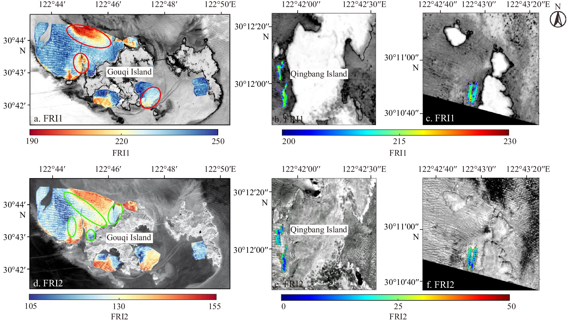
Table 6. Comparison of FRI in Gouqi Island mussel aquaculture area (high sediment concentration)
Group FRI1 DN difference value FRI2 DN difference value Group 1 4.2715 11.5829 Group 2 1.1421 7.8749 Group 3 5.6927 7.9030 Group 4 1.2801 3.9819 Group 5 3.1422 8.9573 Group 6 1.2521 6.1892 Group 7 2.9368 8.1809 Group 8 4.9435 11.4821 Group 9 33.5121 25.2411 Group 10 15.9151 17.1548 7.4088 10.8548 Note: The values in the table represent the water body and floating raft DN differences (from the FRI), and the bold numbers are average values. In the mussel aquaculture area with high sediment concentration, the difference between FRI2 sampling point pairs was greater than that of FRI1.
下载: 导出CSV
Table 7. Comparison of FRI in Gouqi Island mussel aquaculture area (low sediment concentration)
Group FRI1 DN difference value FRI2 DN difference value Group 1 17.2449 16.5857 Group 2 16.9885 18.6439 Group 3 16.7788 7.4004 Group 4 12.7052 10.1599 Group 5 11.5455 8.1728 Group 6 10.0933 9.1448 Group 7 13.3005 9.4569 Group 8 12.5430 8.6315 Group 9 12.5499 8.0211 Group 10 14.5369 6.8512 13.8286 10.3068 Note: The values in the table represent the water body and floating raft DN differences (from the FRI), and the bold numbers are average values. There was no significant difference between the FRI1 and FRI2 extraction in the mussel aquaculture area with low sediment concentration, but the difference between FRI1 sampling point pairs was still greater than that of FRI2.
下载: 导出CSV
Table 8. Comparison of FRI in Qingbang large yellow croaker aquaculture area
Group FRI1 DN difference value FRI2 DN difference value Group 1 24.4985 99.2819 Group 2 6.9483 197.2781 Group 3 22.626 0 135.5604 Group 4 54.2082 119.9738 Group 5 21.4199 105.0091 Group 6 21.4233 152.3744 25.1874 134.9130 Note: The values in the table represent the water body and floating raft DN differences (from the FRI), and the bold numbers are average values. In the large yellow croaker aquaculture area, the difference of sampling point pairs by the FRI2 method was significantly larger than that by FRI1.
下载: 导出CSV
Table 9. Summary of marine environment factors in Zhoushan aquaculture areas
Area SST/℃ SSC/
(mg · L–1)SSS Chl-a concentration/
(μg · L–1)Current velocity/
(m · s–1)Depth/m Seafloor
sedimentUpwelling Zhoushan mussel
aquaculture area12–26 200–800 20–30 2–8 0.16–1.00 >15 silty clay have Zhoushan large yellow
croaker aquaculture area12.6–26 250–600 20–30 3–9 0.20–2.00 >17 oozy and
silty clayhave
下载: 导出CSV
-
Apte D, Narayana S, Dutta S. 2019. Impact of sea surface temperature anomalies on giant clam population dynamics in Lakshadweep reefs: inferences from a fourteen years study. Ecological Indicators, 107: 105604, doi: 10.1016/j.ecolind.2019.105604 Bai Zhaoguang. 2013. Technical characteristics of Gaofen-1 satellite. Aerospace China (in Chinese), 2013(8): 5–9 Bai Siqi, Zou Xiaorong, Zhang Peng, et al. 2021. Study on spatial heterogeneity effect of environmental factors on distribution of Chilean jack mackerel in Southeast Pacific Ocean. South China Fisheries Science (in Chinese), 17(1): 17–24, doi: 10.12131/20200172 Barsi J A, Schott J R, Hook S J, et al. 2014. Landsat-8 thermal infrared sensor (TIRS) vicarious radiometric calibration. Remote Sensing, 6(11): 11607–11626, doi: 10.3390/rs61111607 Blix K, Pálffy K, Tóth V R, et al. 2018. Remote sensing of water quality parameters over lake balaton by using Sentinel-3 OLCI. Water, 10(10): 1428, doi: 10.3390/w10101428 Cai Lina, Tang Rong, Yan Xiaojun, et al. 2022. The spatial-temporal consistency of chlorophyll-a and fishery resources in the water of the Zhoushan archipelago revealed by high resolution remote sensing. Frontiers in Marine Science, 9: 1022375, doi: 10.3389/fmars.2022.1022375 Cai Lina, Zhou Minrui, Liu Jianqiang, et al. 2020. HY-1C observations of the impacts of islands on suspended sediment distribution in Zhoushan coastal waters, China. Remote Sensing, 12(11): 1766, doi: 10.3390/rs12111766 Chang Jianbo. 1985. Japan builds new floating reef. Marine Fisheries (in Chinese), 1985(4): 191 Chen Fei. 2011. Research on industrialization development of large yellow croaker s cultivation in Zhejiang (in Chinese)[dissertation]. Zhoushan: Zhejiang Ocean University Chen Peng, Chen Xinjun, Lei Lin. 2018b. Influence of Peruvian upwelling on the anchoveta (Engraulis ringens) fishing ground. Journal of Fisheries of China (in Chinese), 42(9): 1367–1377, doi: 10.11964/jfc.20170410806 Chen Hanyue, Zhu Li, Li Jiaguo, et al. 2018a. A comparison of two mono-window algorithms for retrieving sea surface temperature from Landsat8 data in coastal water of Hongyan River nuclear power station. Remote Sensing for Land & Resources (in Chinese), 30(1): 45–53, doi: 10.6046/gtzyyg.2018.01.07 Cheng K H, Chan S N, Lee J H W. 2020. Remote sensing of coastal algal blooms using unmanned aerial vehicles (UAVs). Marine Pollution Bulletin, 152: 110889, doi: 10.1016/j.marpolbul.2020.110889 Cheng Liang, Ma Youhua, Huang Yanyan, et al. 2011. Comparison of atmospheric correction between ENVI FLAASH and ERDAS ATCOR2. Agriculture Network Information (in Chinese), (12): 17–20, doi: 10.3969/j.issn.1672-6251.2011.12.006 Cui Xiaosong, Zhao Chenghai. 2005. Accuracy analysis of ADCP test in lake discharge test. Express Water Resources & Hydropower Information (in Chinese), 26(7): 18–20, doi: 10.15974/j.cnki.slsdkb.2005.07.005 De Mendonça J C, Lopes F B, De Andrade E M, et al. 2017. Monitoring water quality in a reservoir of the semi-arid region using remote sensing. Journal of Experimental Agriculture International, 19(1): 1–12, doi: 10.9734/JEAI/2017/37913 Dinguirard M, Slater P N. 1999. Calibration of space-multispectral imaging sensors: A review. Remote Sensing of Environment, 68(3): 194–205, doi: 10.1016/S0034-4257(98)00111-4 Dong Jiabin, Huang Xinqing. 2019. Typhoon track classification and rainstorm area analysis in Zhejiang. Journal of Zhejiang Meteorology (in Chinese), 40(3): 13–19, doi: 10.16000/j.cnki.zjqx.2019.03.003 Guo Han. 2018. HY-1C satellite. Satellite Application (in Chinese), (10): 66 Han Jiwei, Shao Jun, Fu Weii, et al. 2021b. ADCP velocity measurement by towing method based on micro-nano bubble tracer. Journal of China Hydrology (in Chinese), 41(2): 63–68, doi: 10.19797/j.cnki.1000-0852.20190306 Han Jie, Tao Zui, Xie Yong, et al. 2021a. A novel radiometric cross-calibration of GF-6/WFV with MODIS at the dunhuang radiometric calibration site. IEEE Journal of Selected Topics in Applied Earth Observations and Remote Sensing, 14: 1645–1653, doi: 10.1109/JSTARS.2020.3046738 Hu Mingna. 2007. Coastal upwelling in the Zhoushan and its adjacent seas detected by satellite measurements (in Chinese)[dissertation]. Qingdao: Ocean University of China Hu Jilian. 2020. Study on settlement velocity of near-shore suspended body in Zhoushan fishing ground. Rural Economy and Science-Technology (in Chinese), 31(3): 72–74,111, doi: 10.3969/j.issn.1007-7103.2020.03.033 Hu Qiwei, Chen Xiaoyan, Huang Wanyi, et al. 2021. Phytoplankton bloom triggered by eddy-wind interaction in the upwelling region East of Hainan Island. Journal of Marine Systems, 214: 103470, doi: 10.1016/j.jmarsys.2020.103470 Huang Lingguang, Fang Yu, Zhang Dawen, et al. 2016. Quantitative retrieval of chlorophyll a concentration based on Landsat-8 OLI in the lakes. Jiangxi Science (in Chinese), 34(4): 441–444,456, doi: 10.13990/j.issn1001-3679.2016.04.009 Huo Fuhuai. 1996. Four major fishing grounds in the world. Journal of Educational Studies (in Chinese), (6): 39 Jia Kun, Liang Shunlin, Gu Xingfa, et al. 2016. Fractional vegetation cover estimation algorithm for Chinese GF-1 wide field view data. Remote Sensing of Environment, 177: 184–191, doi: 10.1016/j.rse.2016.02.019 Jiang Zongchen, Ma Yi. 2020. Accurate extraction of offshore raft aquaculture areas based on a 3D-CNN model. International Journal of Remote Sensing, 41(14): 5457–5481, doi: 10.1080/01431161.2020.1737340 Kimambo O N, Chikoore H, Gumbo J R, et al. 2019. Retrospective analysis of Chlorophyll-a and its correlation with climate and hydrological variations in Mindu Dam, Morogoro, Tanzania. Heliyon, 5(11): e02834, doi: 10.1016/j.heliyon.2019.e02834 Lei Sen, Zou Zhengxia, Liu Dunge, et al. 2018. Sea-land segmentation for infrared remote sensing images based on superpixels and multi-scale features. Infrared Physics & Technology, 91: 12–17, doi: 10.1016/j.infrared.2018.03.012 Li Siyuan, He Zhijiang, Yu Hongyue, et al. 2021a. Comparative study on microbial community in mussel mytilus coruscus body and seawater of its natural and cultural sea area in Zhoushan, Zhejiang. Oceanologia et Limnologia Sinica (in Chinese), 52(1): 196–205, doi: 10.11693/hyhz20200700217 Li Yan, Shang Shaoling, Zhang Caiyun, et al. 2006. Remote sensing of algal blooms using a turbidity-free function for near-infrared and red signals. Chinese Science Bulletin, 51(4): 464–471, doi: 10.1007/s11434-006-0464-2 Li Liwei, Wang Wei, Wu Xuejiao. 2019. Study on orthorectification and image fusion algorithm of GF-1 satellite imagery in forest resource extraction. Journal of Green Science and Technology (in Chinese), (8): 219–222, doi: 10.16663/j.cnki.lskj.2019.08.079 Li Xiaoyu, Yu Rencheng, Geng Huixia, et al. 2021b. Increasing dominance of dinoflagellate red tides in the coastal waters of Yellow Sea, China. Marine Pollution Bulletin, 168: 112439, doi: 10.1016/J.MARPOLBUL.2021.112439 Liang Xiaoxia. 2018. Long March 2C carrier rocket successfully launched HY-1C satellite. Missiles and Space Vehicles (in Chinese), (5): 56 Liu Min, De Mitcheson Y S. 2008. Profile of a fishery collapse: why mariculture failed to save the large yellow croaker. Fish and Fisheries, 9(3): 219–242, doi: 10.1111/j.1467-2979.2008.00278.x Loveland T R, Irons J R. 2016. Landsat 8: the plans, the reality, and the legacy. Remote Sensing of Environment, 185: 1–6, doi: 10.1016/j.rse.2016.07.033 Lu Xiaojie, Dong Changming, Li Gang. 2018. Variations of typhoon frequency and landfall position in East China Sea from 1951 to 2015. Transactions of Atmospheric Sciences (in Chinese), 41(4): 433–440, doi: 10.13878/j.cnki.dqkxxb.20170803001 Ma Yichao, Mi Hongyan, Zhong Kai. 2018. Research on urban ecological environment of high resolution remote sensing image based on ENVI. Computer Engineering & Software (in Chinese), 39(11): 235–238, doi: 10.3969/j.issn.1003-6970.2018.11.049 Ma Junying, Yang Jiming. 1994. Marine ranch studies in Japan. Marine Sciences (in Chinese), (3): 23–24 Massarelli C, Galeone C, Savino I, et al. 2021. Towards sustainable management of mussel farming through high-resolution images and open source software-the taranto case study. Remote Sensing, 13(15): 2985, doi: 10.3390/rs13152985 Miller R L, McKee B A. 2004. Using MODIS Terra 250 m imagery to map concentrations of total suspended matter in coastal waters. Remote Sensing of Environment, 93(1-2): 259–266, doi: 10.1016/j.rse.2004.07.012 Nazeer M, Nichol J E. 2016. Development and application of a remote sensing-based Chlorophyll-a concentration prediction model for complex coastal waters of Hong Kong. Journal of Hydrology, 532: 80–89, doi: 10.1016/j.jhydrol.2015.11.037 Ottinger M, Clauss K, Kuenzer C. 2017. Large-scale assessment of coastal aquaculture ponds with Sentinel-1 time series data. Remote Sensing, 9(5): 440, doi: 10.3390/rs9050440 Paulino C, Segura M, Chacón G. 2016. Spatial variability of jumbo flying squid (Dosidicus gigas) fishery related to remotely sensed SST and chlorophyll-a concentration (2004–2012). Fisheries Research, 173: 122–127, doi: 10.1016/j.fishres.2015.10.006 Perkins S. 2019. Inner workings: ramping up the fight against Florida’s red tides. Proceedings of the National Academy of Sciences of the United States of America, 116(14): 6510–6512, doi: 10.1073/pnas.1902219116 Platt T, Shah P, George G, et al. 2015. Use of remote sensing in the context of cage aquaculture. In: Proceedings of the 5th International Symposium on Cage Aquaculture in Asia. Kochi, India: CMFRI and Asian Fisheries Society Qin Zhihao, Karnieli A. 1999. Progress in the remote sensing of land surface temperature and ground emissivity using NOAA-AVHRR data. International Journal of Remote Sensing, 20(12): 2367–2393, doi: 10.1080/014311699212074 Qin Zhihao, Karnieli A, Berliner P. 2001. A mono-window algorithm for retrieving land surface temperature from Landsat TM data and its application to the Israel-Egypt border region. International Journal of Remote Sensing, 22(18): 3719–3746, doi: 10.1080/01431160010006971 Reporter. 2020. Implement the guiding principles of the fifth Plenary Session of the 19th CPC Central Committee. People’s Daily (in Chinese), 2020-11-12, doi: 10.28655/n.cnki.nrmrb.2020.011245 Roy D P, Wulder M A, Loveland T R, et al. 2014. Landsat-8: science and product vision for terrestrial global change research. Remote Sensing of Environment, 145: 154–172, doi: 10.1016/j.rse.2014.02.001 Sarala D, Jacob S. 2014. Digital image processing—A remote sensing perspective. International Journal of Innovative Research and Development, 3(12): 295–300 Setiawati M D, Sambah A B, Miura F, et al. 2015. Characterization of bigeye tuna habitat in the southern waters off Java–Bali using remote sensing data. Advances in Space Research, 55(2): 732–746, doi: 10.1016/j.asr.2014.10.007 Shafeeque M, Balchand A N, Shah P, et al. 2021. Spatio-temporal variability of chlorophyll-a in response to coastal upwelling and mesoscale eddies in the south eastern Arabian Sea. International Journal of Remote Sensing, 42(13): 4836–4863, doi: 10.1080/01431161.2021.1899329 Shikata T, Taniguchi E, Sakamoto S, et al. 2020. Phylogeny, growth and toxicity of the noxious red-tide dinoflagellate Alexandrium leei in Japan. Regional Studies in Marine Science, 36: 101265, doi: 10.1016/j.rsma.2020.101265 Song Yaming. 2001. Hydrological characteristics of Zhoushan Islands. Journal of China Hydrology (in Chinese), 21(6): 59–62, doi: 10.3969/j.issn.1000-0852.2001.06.019 Sui Baikai, Jiang Tao, Zhang Zhen, et al. 2020. A modeling method for automatic extraction of offshore aquaculture zones based on semantic segmentation. ISPRS International Journal of Geo-Information, 9(3): 145, doi: 10.3390/ijgi9030145 Sun Jun. 2005. Zeng Chengkui: life as a marine scientist. China Education Daily (in Chinese), 2005-03-24 Sun Pan, Dong Yusen, Chen Weitao, et al. 2016. Research on fusion of GF-2 imagery and quality evaluation. Remote Sensing for Natural Resources (in Chinese), 28(4): 108–113, doi: 10.6046/gtzyyg.2016.04.17 Tan Saichun, Shi Guangyu. 2006. Remote sensing for ocean primary productivity and its spatio-temporal variability in the China Seas. Acta Geographica Sinica (in Chinese), 61(11): 1189–1199, doi: 10.3321/j.issn:0375-5444.2006.11.008 Teng Yue, Zou Bin, Ye Xiaomin. 2022. Study on the chlorophyll a concentration retrieved from HY-1C satellite coastal zone imager data. Haiyang Xuebao (in Chinese), 44(5): 25–34 Torregroza-Espinosa A C, Restrepo J C, Escobar J, et al. 2021. Spatial and temporal variability of temperature, salinity and chlorophyll-a in the Magdalena River mouth, Caribbean Sea. Journal of South American Earth Sciences, 105: 102978, doi: 10.1016/j.jsames.2020.102978 Viúdez Á, Balsells M F P, Rodríguez-Marroyo R. 2016. Artificial upwelling using offshore wind energy for mariculture applications. Scientia Marina, 80(S1): 235–248, doi: 10.3989/scimar.04297.06B Wang Xu. 2018. A LM-2D carrier rocket successfully sends GF-6 satellite into orbit. Aerospace China (in Chinese), (6): 14, doi: 10.3969/j.issn.1002-7742.2018.06.004 Wang Fei, Qin Zhihao, Song Caiying, et al. 2015. An improved mono-window algorithm for land surface temperature retrieval from Landsat 8 thermal infrared sensor data. Remote Sensing, 7(4): 4268–4289, doi: 10.3390/rs70404268 Wang Zhihua, Yang Xiaomei, Liu Yueming, et al. 2018. Extraction of coastal raft cultivation area with heterogeneous water background by thresholding object-based visually salient NDVI from high spatial resolution imagery. Remote Sensing Letters, 9(9): 839–846, doi: 10.1080/2150704X.2018.1468103 Wang Wei, Yang Fang, Zhang Peng, et al. 2020. An approach for automatic preprocessing of high-resolution remote sensing data and vegetation extraction based on ENVI/IDL: a case study of hunan forestry. Journal of Hunan City University (Natural Science)(in Chinese), 29(2): 45–50, doi: 10.3969/j.issn.1672-7304.2020.02.0012 Wei Guifeng, Tang Danling, Wang Sufen. 2008. Distribution of chlorophyll and harmful algal blooms (HABs): a review on space based studies in the coastal environments of Chinese marginal seas. Advances in Space Research, 41(1): 12–19, doi: 10.1016/j.asr.2007.01.037 Wilkens J L, Katzenmeyer A W, Hahn N M, et al. 2015. Laboratory test of suspended sediment effects on short-term survival and swimming performance of juvenile Atlantic sturgeon (Acipenser oxyrinchus oxyrinchus, Mitchill, 1815). Journal of Applied Ichthyology, 31(6): 984–990, doi: 10.1111/jai.12875 Wong W H, Levinton J S. 2004. Culture of the blue mussel Mytilus edulis (Linnaeus, 1758) fed both phytoplankton and zooplankton: a microcosm experiment. Aquaculture Research, 35(10): 965–969, doi: 10.1111/j.1365-2109.2004.01107.x Xu Hanqiu. 2015. Retrieval of the reflectance and land surface temperature of the newly-launched Landsat 8 satellite. Chinese Journal of Geophysics (in Chinese), 58(3): 741–747, doi: 10.6038/cjg20150304 Xu Jiakang, Peng Lihua, Gao Wei, et al. 2017. Effects of light intensity, water temperature and density on aggregation of juvenile mussel Mytilus coruscus. Journal of Dalian Ocean University (in Chinese), 32(3): 275–279, doi: 10.16535/j.cnki.dlhyxb.2017.03.004 Yan Hua, Chen Ying. 2021. Analysis of relative radiometric correction method for GF-6 satellite. Science & Technology Vision (in Chinese), (3): 5–8, doi: 10.19694/j.cnki.issn2095-2457.2021.03.02 Yan Mingjun, Hu Chunting, Lin Danging, et al. 2020. The diversity of fish communities and the effects of tidal intensity in the near-shore lower reaches of Yangtze River. Chinese Journal of Ecology (in Chinese), 39(6): 1865–1874, doi: 10.13292/j.1000-4890.202006.030 Yang Long. 2020. ENVI high-resolution remote sensing image data preprocessing. Journal of Jiaozuo University (in Chinese), 34(1): 97–100, doi: 10.16214/j.cnki.cn41-1276/g4.2020.01.022 Yang Hongsheng, Huo Da, Xu Qiang. 2016. Views on modern marine ranching. Oceanologia et Limnologia Sinica (in Chinese), 47(6): 1059–1074, doi: 10.11693/hyhz20160900203 Yang Xianping, Sokoletsky L, Hui Wu. 2017. Water quality seasonal variability (2000 to 2015) in Yangtze River estuary and its adjacent coastal area. Journal of Remote Sensing & GIS, 6(4): 1000216 Yang Yipeng, Wang Qiao, Xiao Qing, et al. 2006. Quantitative remote sensing inversion methods of chlorophyll-a concentration in Taihu Lake based on TM data. Geography and Geo-Information Science, 22(2): 5–8, doi: 10.3969/j.issn.1672-0504.2006.02.002 Yang Hongsheng, Zhou Yi. 1998. Research progress on the effects of filter-feeding shellfish on the environment of cultured Marine areas. Marine Sciences, (2): 42–44 Yao Ru, Cai Lina, Liu Jianqiang, et al. 2020. GF-1 satellite observations of suspended sediment injection of Yellow River Estuary, China. Remote Sensing, 12(19): 3126, doi: 10.3390/rs12193126 Ye Wei, Song Wei. 2020. Quantitative remote sensing monitoring of water quality in Bohai Bay based on Landsat multispectral data. E3S Web of Conferences, 206: 03007, doi: 10.1051/e3sconf/202020603007 Ye Yingying, Xu Meiying, Wu Changwen. 2011. Influences of some environmental factors on growth and survival of mytilus coruscus gould larvae. Journal of Zhejiang Ocean University (Natural Science) (in Chinese), 30(4): 292–296, doi: 10.3969/j.issn.1008-830X.2011.04.003 Yu Cungen, Chen Quanzhen, Chen Xiaoqing, et al. 2010. Species composition and quantitative distribution of fish in the Zhoushan fishing ground and its adjacent waters. Oceanologia et Limnologia Sinica (in Chinese), 41(3): 410–417 Yu Huijuan, Wang Jinhuan. 2015. From the strategic point of view, the construction of marine ranching should be emphasized and promoted. Rural Economy (in Chinese), (3): 50–53 Yu Cungen, Yan Xiaojun, Jiang Qiaoli, et al. 2022. Cause analysis of resources change and reconstruction strategy of Larimichthys crocea Daiqu group in the East China Sea. Journal of Fisheries of China (in Chinese), 46(4): 616–625, doi: 10.11964/jfc.20211013126 Yu Xiang, Yi Huapeng, Liu Xiangyang, et al. 2016. Remote-sensing estimation of dissolved inorganic nitrogen concentration in the Bohai Sea using band combinations derived from MODIS data. International Journal of Remote Sensing, 37(2): 327–340, doi: 10.1080/01431161.2015.1125555 Yuan Xinzhe, Lin Mingsen, Liu Jianqiang, et al. 2018. Application of GF-3 satellite in marine field. Satellite Application, (6): 17–21, doi: 10.3969/j.issn.1674-9030.2018.06.007 Zang Xi. 2018. Comparative study on fusion methods of GF-2 satellite image in land engineering application. China Western Developmen (in Chinese), 3(11): 7–12,17 Zhai Z K, Lu S L, Wang P, et al. 2021. Ocean Chlorophyll-a retrieval using GF1-WFV data—A case study of the central Bohai Sea. IOP Conference Series: Earth and Environmental Science, 626(1): 012021, doi: 10.1088/1755-1315/626/1/012021 Zhang Yihao. 2009. Study on shape comparison of mussel species in Zhejiang coast. Fisheries Economy Research (in Chinese), (2): 14–20, doi: 10.3969/j.issn.1674-9189.2009.02.004 Zhang Qing, Chen Peng. 2021. Application of gaofen No. 6 satellite in vegetation ecological remote sensing monitoring. Journal of Agriculture (in Chinese), 11(7): 56–59,111, doi: 10.11923/j.issn.2095-4050.cjas20191200315 Zhang Yi, Wang Chengyi, Ji Yuan, et al. 2020. Combining segmentation network and nonsubsampled contourlet transform for automatic marine raft aquaculture area extraction from sentinel-1 images. Remote Sensing, 12(24): 4182, doi: 10.3390/rs12244182 Zhang Tao, Yang Xiaomei, Hu Shanshan, et al. 2013. Extraction of coastline in aquaculture coast from multispectral remote Sensing images: object-based region growing integrating edge detection. Remote Sensing, 5(9): 4470–4487, doi: 10.3390/rs5094470 -


 点击查看大图

计量
- 文章访问数: 104
- HTML全文浏览量: 48
- PDF下载量: 13
- 被引次数: 0

