

A VGGNet-based correction for satellite altimetry-derived gravity anomalies to improve the accuracy of bathymetry to depths of 6 500 m
-
Abstract: Understanding the topographic patterns of the seafloor is a very important part of understanding our planet. Although the science involved in bathymetric surveying has advanced much over the decades, less than 20% of the seafloor has been precisely modeled to date, and there is an urgent need to improve the accuracy and reduce the uncertainty of underwater survey data. In this study, we introduce a pretrained visual geometry group network (VGGNet) method based on deep learning. To apply this method, we input gravity anomaly data derived from ship measurements and satellite altimetry into the model and correct the latter, which has a larger spatial coverage, based on the former, which is considered the true value and is more accurate. After obtaining the corrected high-precision gravity model, it is inverted to the corresponding bathymetric model by applying the gravity-depth correlation. We choose four data pairs collected from different environments, i.e., the Southern Ocean, Pacific Ocean, Atlantic Ocean and Caribbean Sea, to evaluate the topographic correction results of the model. The experiments show that the coefficient of determination (R2) reaches 0.834 among the results of the four experimental groups, signifying a high correlation. The standard deviation and normalized root mean square error are also evaluated, and the accuracy of their performance improved by up to 24.2% compared with similar research done in recent years. The evaluation of the R2 values at different water depths shows that our model can achieve performance results above 0.90 at certain water depths and can also significantly improve results from mid-water depths when compared to previous research. Finally, the bathymetry corrected by our model is able to show an accuracy improvement level of more than 21% within 1% of the total water depths, which is sufficient to prove that the VGGNet-based method has the ability to perform a gravity-bathymetry correction and achieve outstanding results.
-
Key words:
- gravity anomaly /
- bathymetry inversion /
- VGGNet /
- multibeam sonar /
- satellite altimetry
-
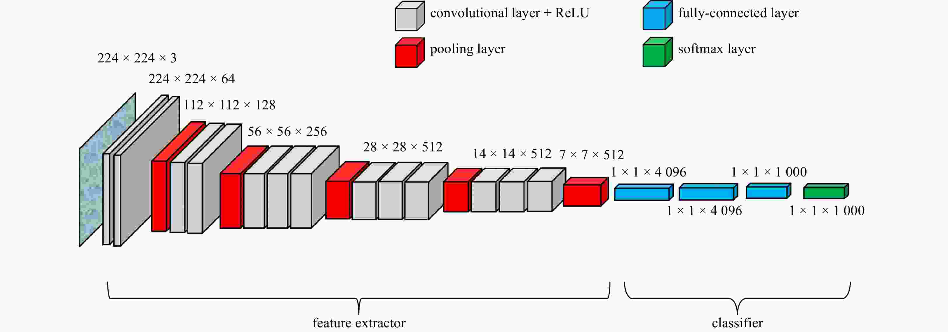
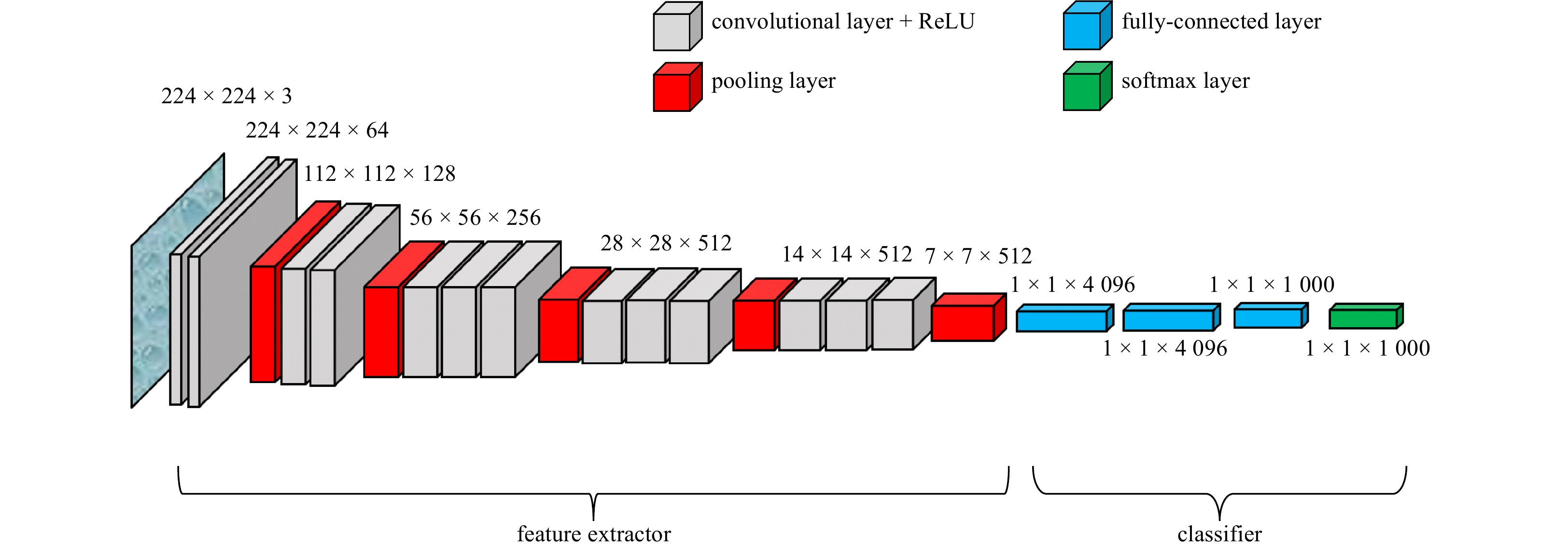
Figure 2. Architecture of the VGG-19 model. The boxes represent the size of each layer.
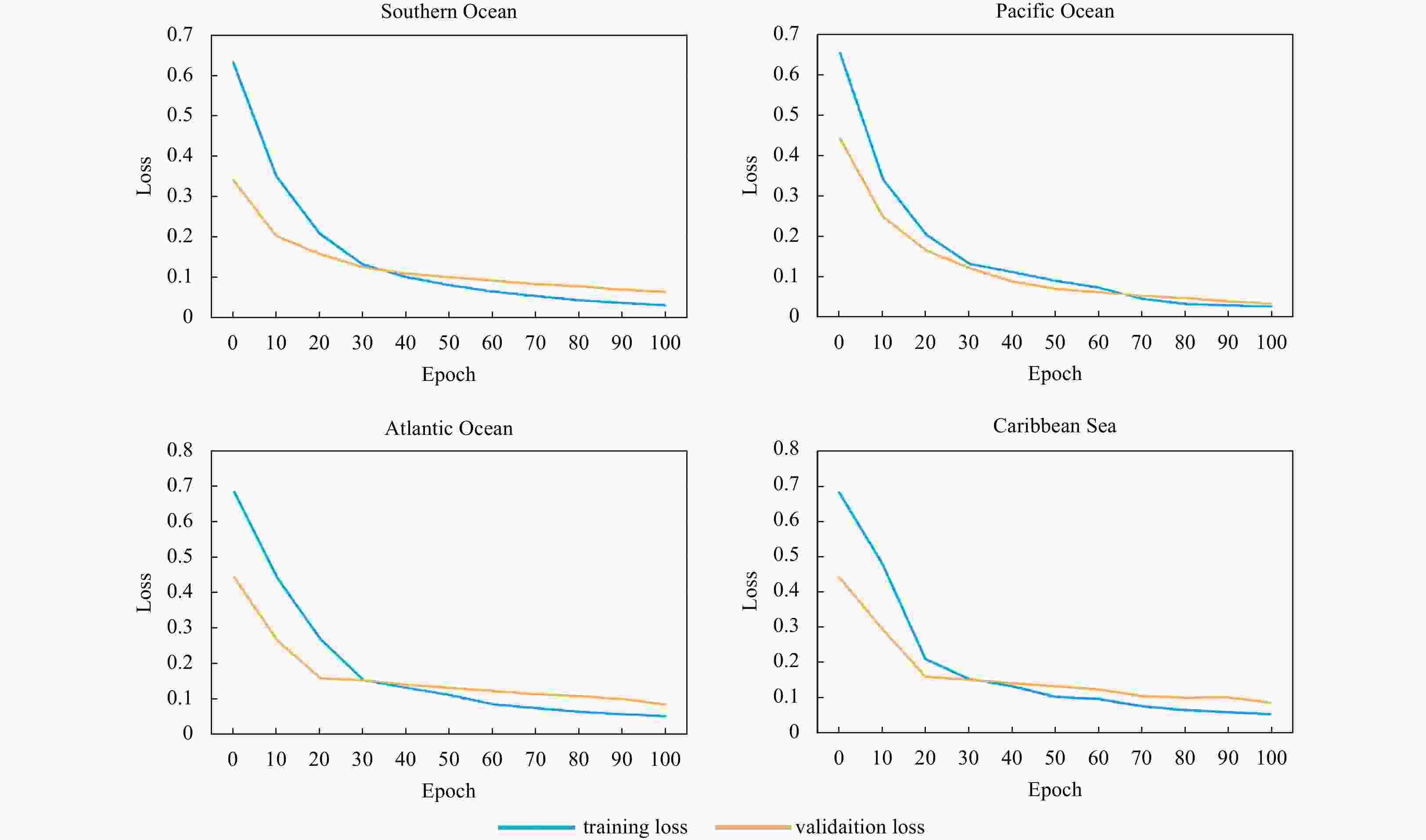
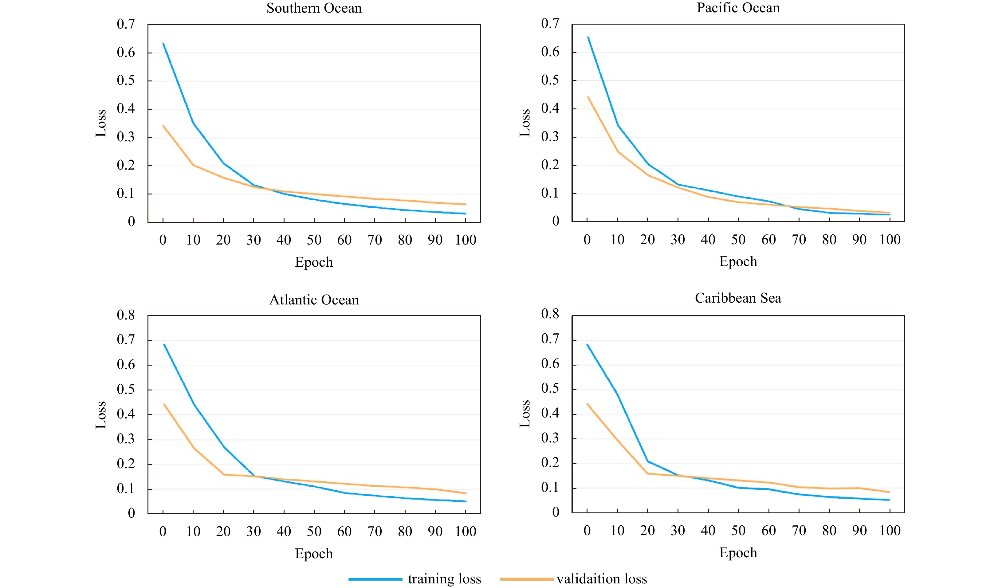
Figure 4. The training and validation loss from the experiments in the Southern Ocean, Pacific Ocean, Atlantic Ocean, and Caribbean Sea.
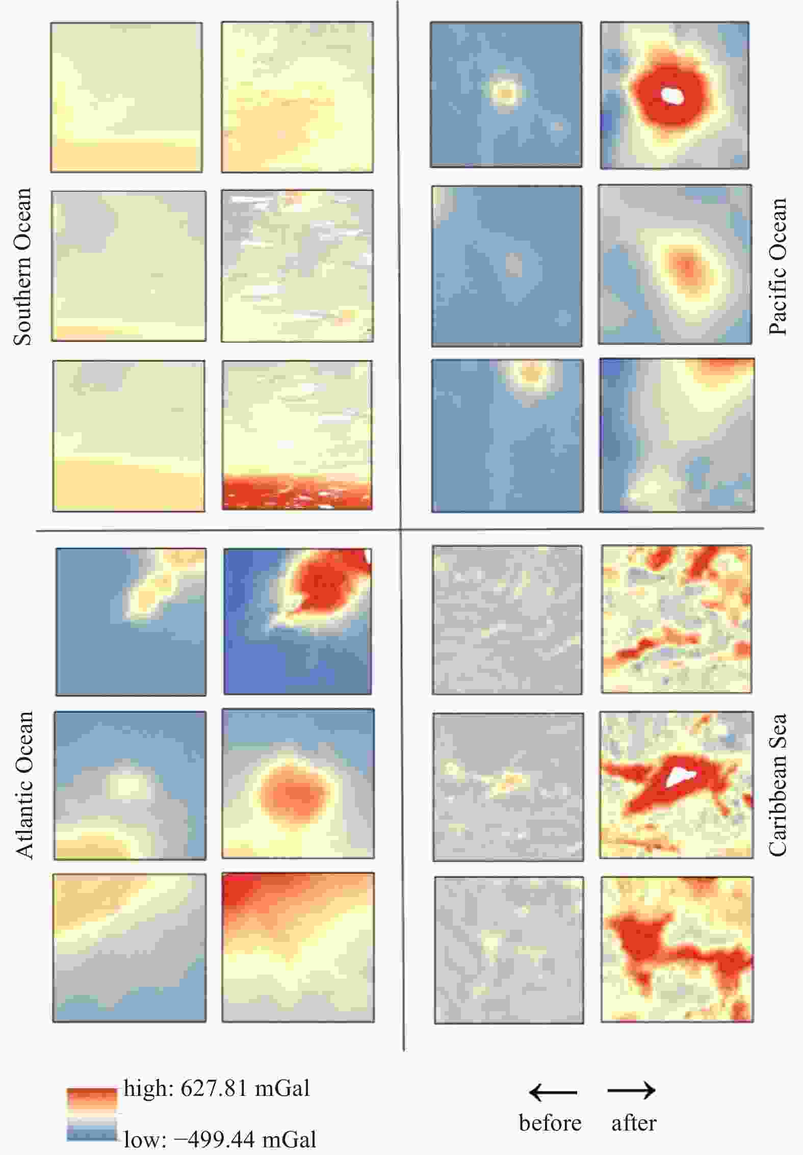
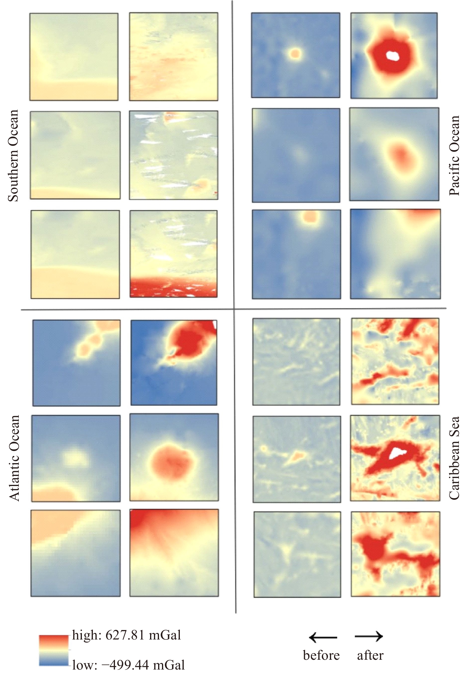
Figure 5. Comparison of local details of gravity anomalies before and after correction from the Southern Ocean, Pacific Ocean, Atlantic Ocean, and Caribbean Sea. Each subfigure shows three visualizations of randomly selected locations.
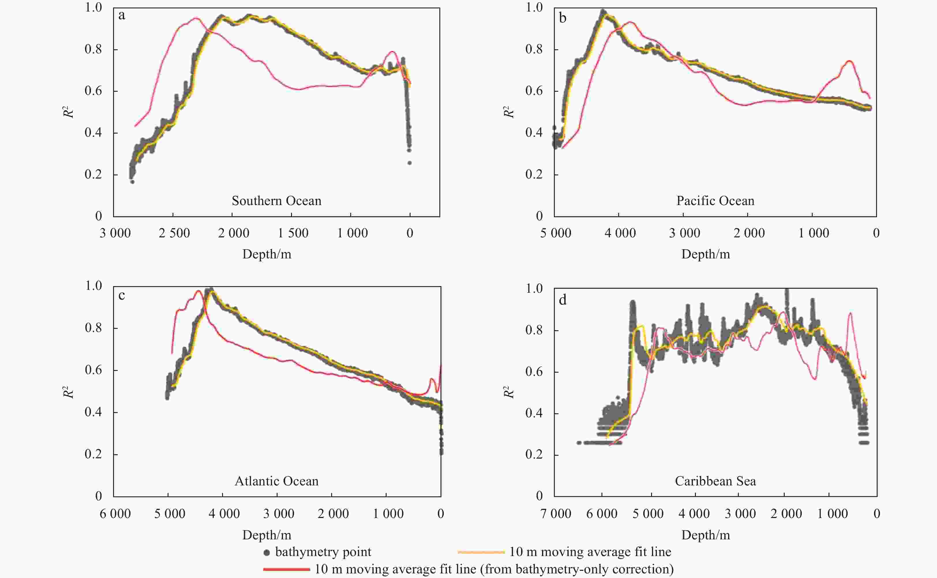
Figure 6. R2 values at different water depths compared with the bathymetry-only correction methos in the Southern Ocean (a), Pacific Ocean (b), Atlantic Ocean (c), and Caribbean Sea (d).
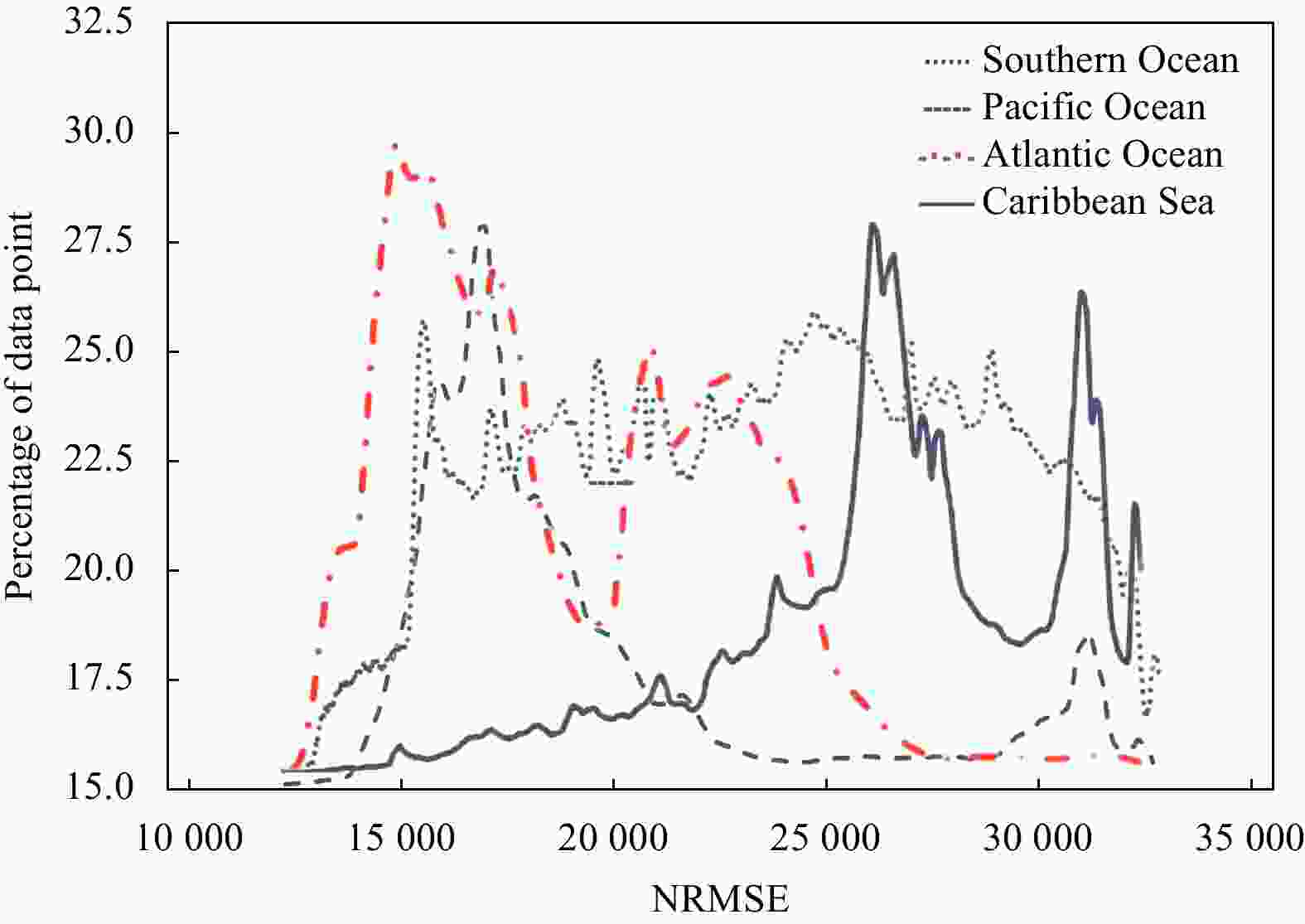
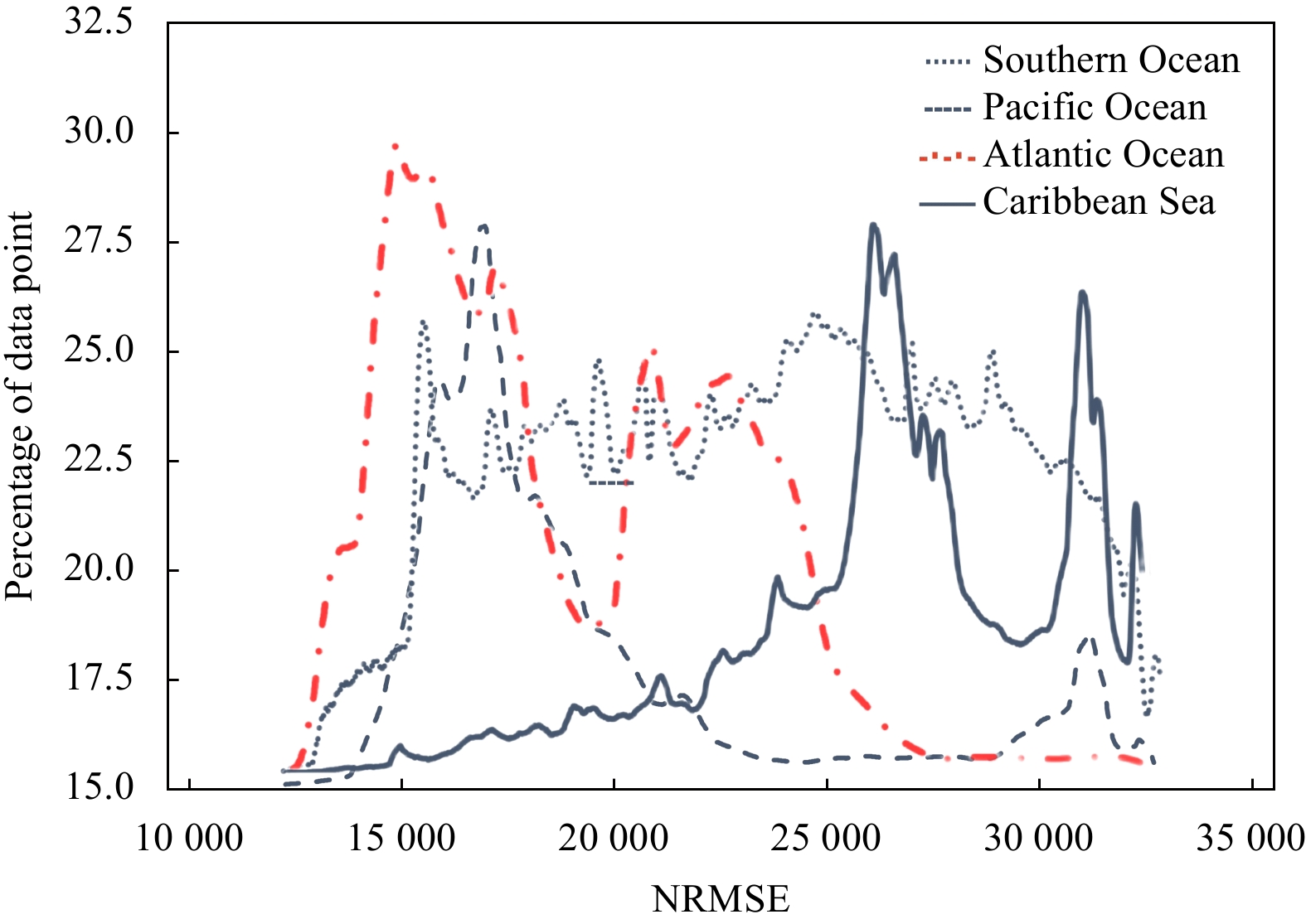
Figure 7. Percentage distributions of NRMSE performance in datasets from the Southern Ocean, Pacific Ocean, Atlantic Ocean, and Caribbean Sea.
Table 1. The default hyperparameters of the training model
Hyperparameter Setting Content layer “conv4_2” Style layer “conv1_1”, “conv2_1”, “conv3_1”, “conv4_1”, “conv5_1” Weight of loss at content layer 1 Weight of loss at style layer 1, 1, 1, 1 Weights among content, style, and total variation loss 1 × 10⁻⁴, 1, 1 × 10⁻⁵
Learning rate starts at 10 and linear decays over 100 iterations to 1  下载: 导出CSV
Table 2. The parameters of the datasets
Location Center point coordinate Spatial resolution/m Data size Area/km2 Bathymetry/m Southern Ocean 71°S, 173°E 93 5 097 104 43 700 211−4077 Pacific Ocean 9°S, 140°W 93 33 048 000 283 337 113−4992 Atlantic Ocean 32°N, 65°W 93 3 240 000 27 778 58−4920 Caribbean Sea 18°N, 82°W 123 10 614 363 150 310 1−6580
下载: 导出CSV
Table 3. Overall accuracy of the gravity correction
Location R2 SD/mGal RMSE/mGal NRMSE Southern Ocean 0.902 18.333 13.630 0.113 Pacific Ocean 0.955 17.892 10.050 0.118 Atlantic Ocean 0.930 19.567 21.549 0.114 Caribbean Sea 0.919 21.051 16.485 0.113
下载: 导出CSV
Table 4. The overall accuracy of the bathymetry correction
Location R2 SD/m RMSE/m NRMSE Southern Ocean 0.822 104.790 107.024 0.027 Pacific Ocean 0.834 117.630 126.366 0.026 Atlantic Ocean 0.833 124.847 136.622 0.028 Caribbean Sea 0.783 139.583 164.475 0.025
下载: 导出CSV
Table 5. Proportion of corrected errors from true values within 2% and 1% of the depth range
Location Proportion of corrected errors/% 1% of depth 2% of depth Southern Ocean 68.05 75.69 Pacific Ocean 61.53 77.52 Atlantic Ocean 57.58 68.69 Caribbean Sea 51.03 64.58
下载: 导出CSV
-
Airy G B. 1855. III. On the computation of the effect of the attraction of mountain-masses, as disturbing the apparent astronomical latitude of stations in geodetic surveys. Philosophical Transactions of the Royal Society of London, 145: 101–104, doi: 10.1098/rstl.1855.0003 An Dechao, Guo Jinyun, Li Zhen, et al. 2022. Improved gravity-geologic method reliably removing the long-wavelength gravity effect of regional seafloor topography: a case of bathymetric prediction in the South China Sea. IEEE Transactions on Geoscience and Remote Sensing, 60: 4211912, doi: 10.1109/TGRS.2022.3223047 Annan R F, Wan Xiaoyun. 2022. Recovering bathymetry of the gulf of guinea using altimetry-derived gravity field products combined via convolutional neural network. Surveys in Geophysics, 43(5): 1541–1561, doi: 10.1007/s10712-022-09720-5 Benedetti P, Ienco D, Gaetano R, et al. 2018. M3Fusion: a deep learning architecture for multiscale multimodal multitemporal satellite data fusion. IEEE Journal of Selected Topics in Applied Earth Observations and Remote Sensing, 11(12): 4939–4949, doi: 10.1109/JSTARS.2018.2876357 Bonvalot S, Balmino G, Briais A, et al. 2012. World gravity map. commission for the geological map of the world. Paris, France: BGI–CGMW-CNES-IRD Braitenberg C, Wienecke S, Wang Yong. 2006. Basement structures from satellite-derived gravity field: South China Sea ridge. Journal of Geophysical Research: Solid Earth, 111(B5): B05407, doi: 10.1029/2005JB003938 Chen Xiaolun, Luo Xiaowen, Wu Ziyin, et al. 2022. A VGGNet-based method for refined bathymetry from satellite altimetry to reduce errors. Remote Sensing, 14(23): 5939, doi: 10.3390/rs14235939 Colbo K, Ross T, Brown C, et al. 2014. A review of oceanographic applications of water column data from multibeam echosounders. Estuarine, Coastal and Shelf Science, 145: 41–56, Coley K. 2022. A global ocean map is not an ambition, but a necessity to support the ocean decade. Marine Technology Society Journal, 56(3): 9–12, doi: 10.4031/MTSJ.56.3.3 Fan Diao, Li Shanshan, Li Xinxing, et al. 2021. Seafloor topography estimation from gravity anomaly and vertical gravity gradient using nonlinear iterative least square method. Remote Sensing, 13(1): 64, doi: 10.3390/rs13010064 Fan Diao, Li Shanshan, Meng Shuyu, et al. 2020. Applying iterative method to solving high-order terms of seafloor topography. Marine Geodesy, 43(1): 63–85, doi: 10.1080/01490419.2019.1670298 Gatys L A, Ecker A S, Bethge M. 2016. A neural algorithm of artistic style. Journal of Vision, 16(12): 326, doi: 10.1167/16.12.326 Gatys L A, Ecker A S, Bethge M, et al. 2017. Controlling perceptual factors in neural style transfer. In: Proceedings of 2017 IEEE Conference on Computer Vision and Pattern Recognition. Honolulu, USA: IEEE, 3730–3738, doi: 10.1109/CVPR.2017.397 Gong Zheng, Zhang Peizhen, Zheng Wenjun, et al. 2021. The effect of altimetry data in estimating the elastic thickness of the lithosphere in the western Pacific Ocean. Geodesy and Geodynamics, 12(5): 315–322, doi: 10.1016/j.geog.2021.07.001 Hu Minzhang, Zhang Shengjun, Jin Taoyong, et al. 2020. A new generation of global bathymetry model BAT_WHU2020. Acta Geodaetica et Cartographica Sinica (in Chinese), 49(8): 939–954, doi: 10.11947/j.AGCS.2020.20190526 Hughes Clarke J E. 2018. Multibeam echosounders. In: Micallef A, Krastel S, Savini A, eds. Submarine Geomorphology. Cham: Springer, 25–41, Huo Guanying, Wu Ziyin, Li Jiabiao. 2020. Underwater object classification in sidescan sonar images using deep transfer learning and semisynthetic training data. IEEE Access, 8: 47407–47418, doi: 10.1109/ACCESS.2020.2978880 Ibrahim A, Hinze W J. 1972. Mapping buried bedrock topography with gravity. Groundwater, 10(3): 18–23, doi: 10.1111/j.1745-6584.1972.tb02921.x Islam M J, Xia Youya, Sattar J. 2020. Fast underwater image enhancement for improved visual perception. IEEE Robotics and Automation Letters, 5(2): 3227–3234, doi: 10.1109/LRA.2020.2974710 Jena B, Kurian P J, Swain D, et al. 2012. Prediction of bathymetry from satellite altimeter based gravity in the Arabian Sea: mapping of two unnamed deep seamounts. International Journal of Applied Earth Observation and Geoinformation, 16: 1–4, doi: 10.1016/j.jag.2011.11.008 Jia Yangqing, Shelhamer E, Donahue J, et al. 2014. Caffe: Convolutional architecture for fast feature embedding. In: Proceedings of the 22nd ACM International Conference on Multimedia. Orlando, USA: Association for Computing Machinery, 675–678, Koh Z W, Nimmo F, Lunine J I, et al. 2022. Assessing the detectability of Europa’s seafloor topography from Europa clipper’s gravity data. The Planetary Science Journal, 3(8): 197, doi: 10.3847/PSJ/ac82aa Krizhevsky A, Sutskever I, Hinton G E. 2017. ImageNet classification with deep convolutional neural networks. Communications of the ACM, 60(6): 84–90, doi: 10.1145/3065386 Li Jiabiao. 1999. Multibeam Survey Principles, Techniques and Methods (in Chinese). Beijing: China Ocean Press Moran N P. 2020. Machine learning model selection for predicting global bathymetry [dissertation]. New Orleans, USA: University of New Orleans NOAA National Centers for Environmental Information. 2004. Multibeam bathymetry database (MBBDB). NOAA National Centers for Environmental Information. https://www.ncei.noaa.gov/maps/bathymetry/[2022-6-14] NOAA National Centers for Environmental Information. 2015. Marine trackline geophysical database. NOAA National Centers for Environmental Information. https://www.ncei.noaa.gov/maps/geophysics/[2022-06-14] Oldenburg D W. 1974. The inversion and interpretation of gravity anomalies. Geophysics, 39(4): 526–536, doi: 10.1190/1.1440444 Otter D W, Medina J R, Kalita J K. 2021. A survey of the usages of deep learning for natural language processing. IEEE Transactions on Neural Networks and Learning Systems, 32(2): 604–624, doi: 10.1109/TNNLS.2020.2979670 Ouyang Mingda, Sun Zhongmiao, Zhai Zhenhe. 2014. Predicting bathymetry in South China Sea using the gravity-geologic method. Chinese Journal of Geophysics (in Chinese), 57(9): 2756–2765, doi: 10.6038/cjg20140903 Ouyang Mingda, Sun Zhongmiao, Zhai Zhenhe, et al. 2015. Bathymetry prediction based on the admittance theory of gravity anomalies. Acta Geodaetica et Cartographica Sinica (in Chinese), 44(10): 1092–1099, doi: 10.11947/j.AGCS.2015.20140427 Parker R L. 1973. The rapid calculation of potential anomalies. Geophysical Journal International, 31(4): 447–455, doi: 10.1111/j.1365-246X.1973.tb06513.x Reddi S J, Kale S, Kumar S. 2018. On the convergence of Adam and beyond. In: Proceedings of the 6th International Conference on Learning Representations. Vancouver, Canada: OpenReview. net Sandwell D T, Goff J A, Gevorgian J, et al. 2022. Improved bathymetric prediction using geological information: SYNBATH. Earth and Space Science, 9(2): e2021EA002069, doi: 10.1029/2021EA002069 Scharroo R, Visser P. 1998. Precise orbit determination and gravity field improvement for the ERS satellites. Journal of Geophysical Research: Oceans, 103(C4): 8113–8127, doi: 10.1029/97JC03179 Schulz M A, Yeo B T T, Vogelstein J T, et al. 2020. Different scaling of linear models and deep learning in UKBiobank brain images versus machine-learning datasets. Nature Communications, 11(1): 4238, doi: 10.1038/s41467-020-18037-z Seoane L, Ramillien G, Beirens B, et al. 2022. Regional seafloor topography by extended Kalman filtering of marine gravity data without ship-track information. Remote Sensing, 14(1): 169, doi: 10.3390/rs14010169 Shi Bo, Lu Xiushan, Yang Fanlin, et al. 2017. Shipborne over- and under-water integrated mobile mapping system and its seamless integration of point clouds. Marine Geodesy, 40(2/3): 104–122, Simonyan K, Zisserman A. 2015. Very deep convolutional networks for large-scale image recognition. In: Proceedings of the 3rd International Conference on Learning Representations. San Diego, USA: Association for Computing Machinery Smith W H F, Sandwell D T. 1994. Bathymetric prediction from dense satellite altimetry and sparse shipboard bathymetry. Journal of Geophysical Research: Solid Earth, 99(B11): 21803–21824, doi: 10.1029/94JB00988 Smith W H F, Sandwell D T. 1997. Global sea floor topography from satellite altimetry and ship depth soundings. Science, 277(5334): 1956–1962, doi: 10.1126/science.277.5334.1956 Walcott R I. 1970. Flexural rigidity, thickness, and viscosity of the lithosphere. Journal of Geophysical Research, 75(20): 3941–3954, doi: 10.1029/JB075i020p03941 Watts A B. 1978. An analysis of isostasy in the world’s oceans 1. Hawaiian-Emperor Seamount Chain. Journal of Geophysical Research: Solid Earth, 83(B12): 5989–6004, doi: 10.1029/JB083iB12p05989 Watts A B. 2001. Isostasy and Flexure of the Lithosphere. Cambridge, UK: Cambridge University Press Watts A B, Sandwell D T, Smith W H F, et al. 2006. Global gravity, bathymetry, and the distribution of submarine volcanism through space and time. Journal of Geophysical Research: Solid Earth, 111(B8): B08408, doi: 10.1029/2005JB004083 Wei Zhijie, Guo Jinyun, Zhu Chengcheng, et al. 2021. Evaluating accuracy of HY-2A/GM-derived gravity data with the gravity-geologic method to predict bathymetry. Frontiers in Earth Science, 9: 636246, doi: 10.3389/feart.2021.636246 Wu Meiyin, Chen Li. 2015. Image recognition based on deep learning. In: Proceedings of 2015 Chinese Automation Congress (CAC). Wuhan, China: IEEE, 542–546, doi: 10.1109/CAC.2015.7382560 Wu Ziyin, Yang Fanlin, Tang Yong, et al. 2020. High-Resolution Seafloor Survey and Applications. Beijing: Science Press Yale M M, Sandwell D T, Herring A T. 1998. What are the limitations of satellite altimetry?. The Leading Edge, 17(1): 73–76, doi: 10.1190/1.1437832 Yuan Qiangqiang, Shen Huanfeng, Li Tongwen, et al. 2020. Deep learning in environmental remote sensing: achievements and challenges. Remote Sensing of Environment, 241: 111716, doi: 10.1016/j.rse.2020.111716 Zhao Jianhu, Ouyang Yongzhong, Wang Aixue. 2017. Status and development tendency for seafloor terrain measurement technology. Acta Geodaetica et Cartographica Sinica (in Chinese), 46(10): 1786–1794, doi: 10.11947/j.AGCS.2017.20170276 Zhu Chengcheng, Guo Jinyun, Yuan Jiajia, et al. 2021. Refining altimeter-derived gravity anomaly model from shipborne gravity by multi-layer perceptron neural network: a case in the South China Sea. Remote Sensing, 13(4): 607, doi: 10.3390/rs13040607 Zwally H J, Schutz B, Abdalati W, et al. 2002. ICESat’s laser measurements of polar ice, atmosphere, ocean, and land. Journal of Geodynamics, 34(3/4): 405–445, -


 点击查看大图
计量
- 文章访问数: 332
- HTML全文浏览量: 134
- PDF下载量: 26
- 被引次数: 0

