Satellite-observed significant improvement in nearshore transparency of the Bohai Sea during pollution control
-
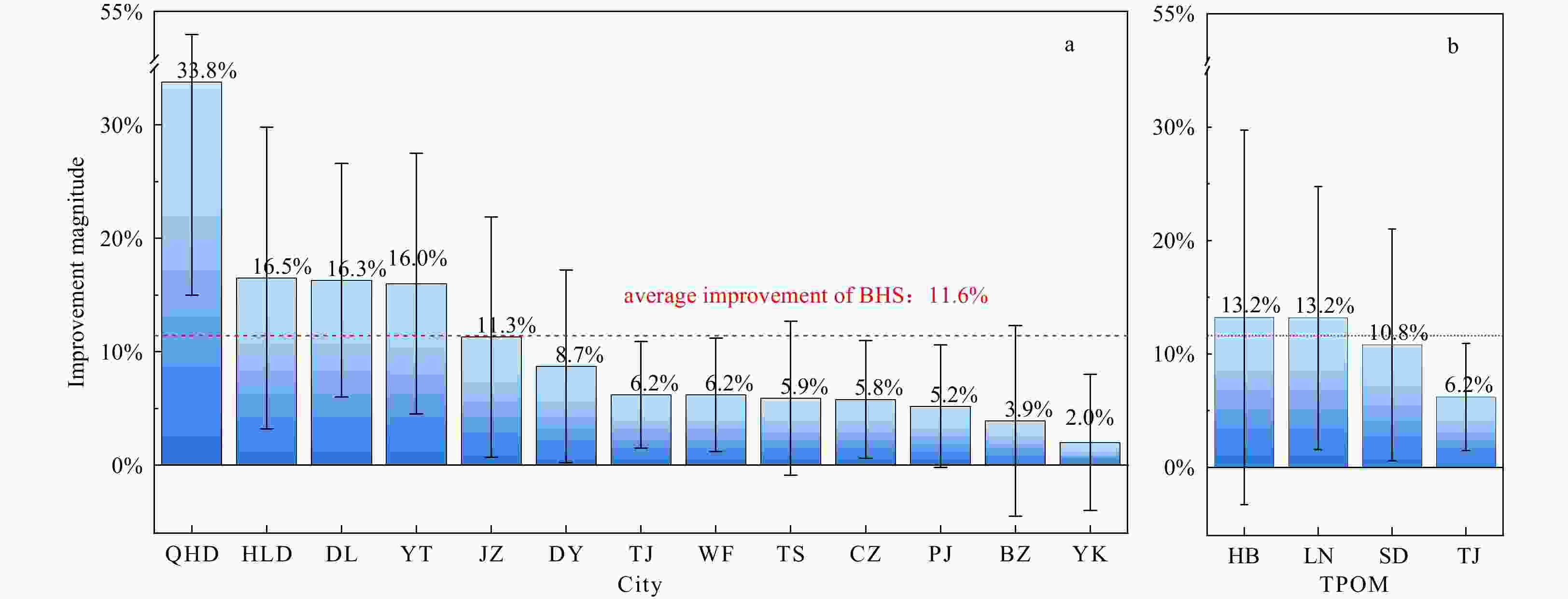
Abstract: The Bohai Sea (BS) is the unique semi-closed inland sea of China, characterized by degraded water quality due to significant terrestrial pollution input. In order to improve its water quality, a dedicated action named “Uphill Battles for Integrated Bohai Sea Management” (UBIBSM, 2018–2020) was implemented by the Chinese government. To evaluate the action effectiveness toward water quality improvement, variability of the satellite-observed water transparency (Secchi disk depth, ZSD) was explored, with special emphasis on the nearshore waters (within 20 km from the coastline) prone to terrestrial influence. (1) Compared to the status before the action began (2011–2017), majority (87.3%) of the nearshore waters turned clear during the action implementation period (2018–2020), characterized by the elevated ZSD by 11.6% ± 12.1%. (2) Nevertheless, the improvement was not spatially uniform, with higher ZSD improvement in provinces of Hebei, Liaoning, and Shandong (13.2% ± 16.5%, 13.2% ± 11.6%, 10.8% ± 10.2%, respectively) followed by Tianjin (6.2% ± 4.7%). (3) Bayesian trend analysis found the abrupt ZSD improvement in April 2018, which coincided with the initiation of UBIBSM, implying the water quality response to pollution control. More importantly, the independent statistics of land-based pollutant discharge also indicated that the significant reduction of terrestrial pollutant input during the UBIBSM action was the main driver of observed ZSD improvement. (4) Compared with previous pollution control actions in the BS, UBIBSM was found to be the most successful one during the past 20 years, in terms of transparency improvement over nearshore waters. The presented results proved the UBIBSM-achieved remarkable water quality improvement, taking the advantage of long-term consistent and objective data record from satellite ocean color observation.
-
Key words:
- Secchi disk depth /
- transparency /
- water quality /
- nearshore /
- Bohai Sea /
- satellite ocean color remote sensing /
- pollution control
-
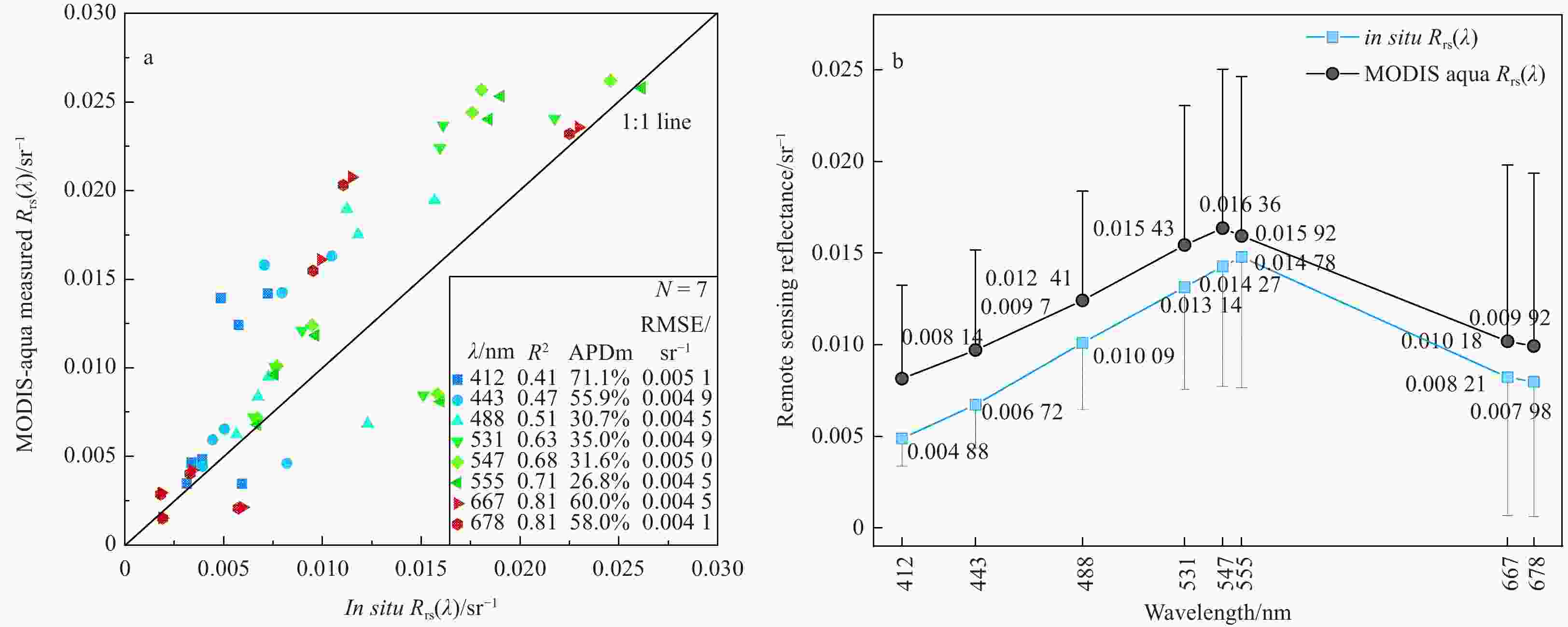
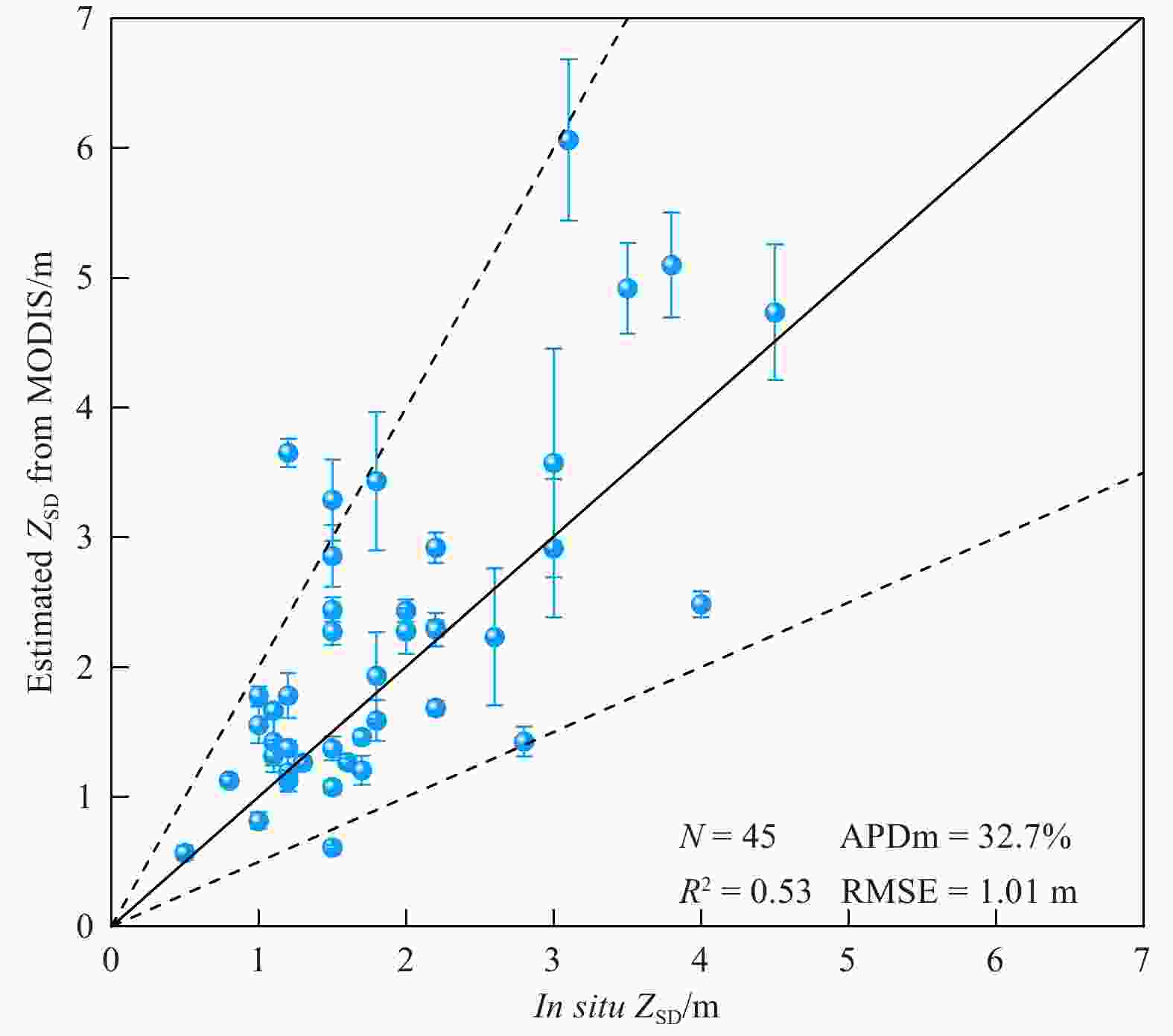
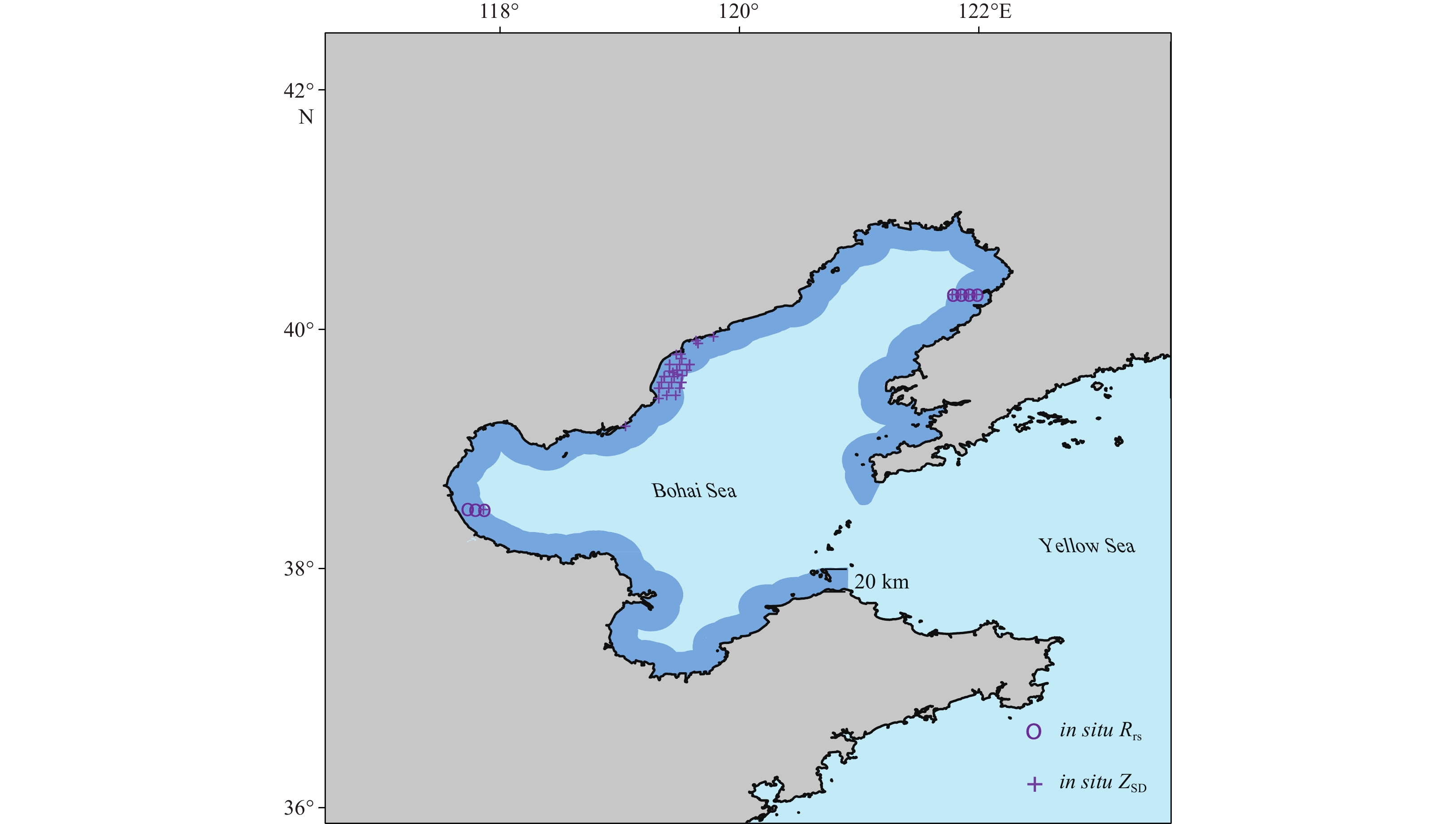
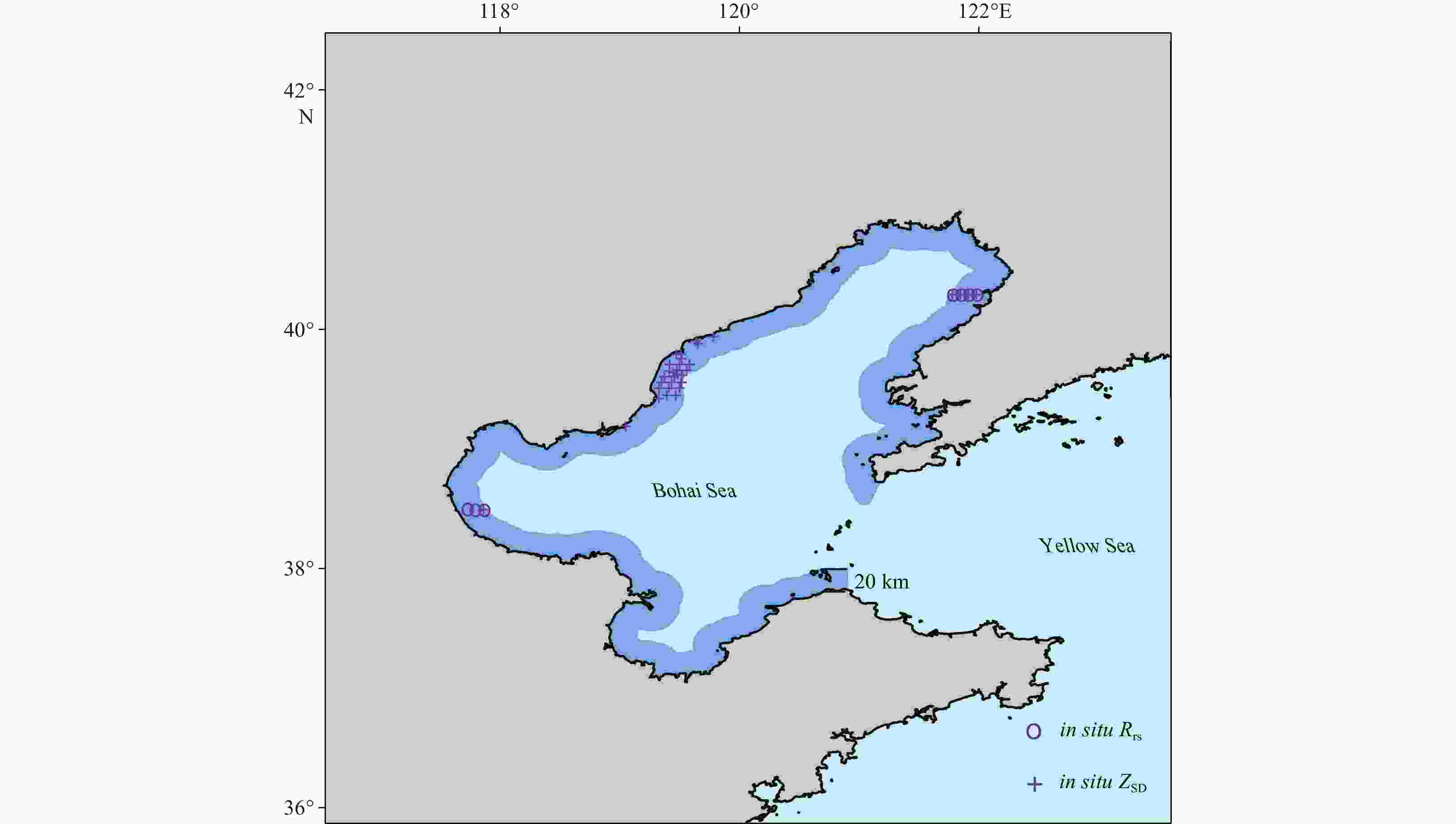
Figure 1. Location of Bohai Sea and the surrounding TPOM. The study area is nearshore waters (the dark blue region), which is within 20 km from the coastline, with average depth of about 11 m. Purple circles and crosses represent the sites with Rrs(λ) (N = 7) and ZSD (N = 45) observations, respectively. It is noted that these 2 measurements are available at 5 stations.
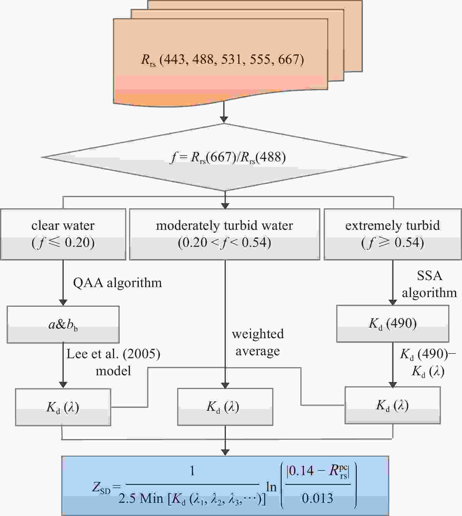
Figure 3. Diagram of ZSD retrieval model. In the blue box,
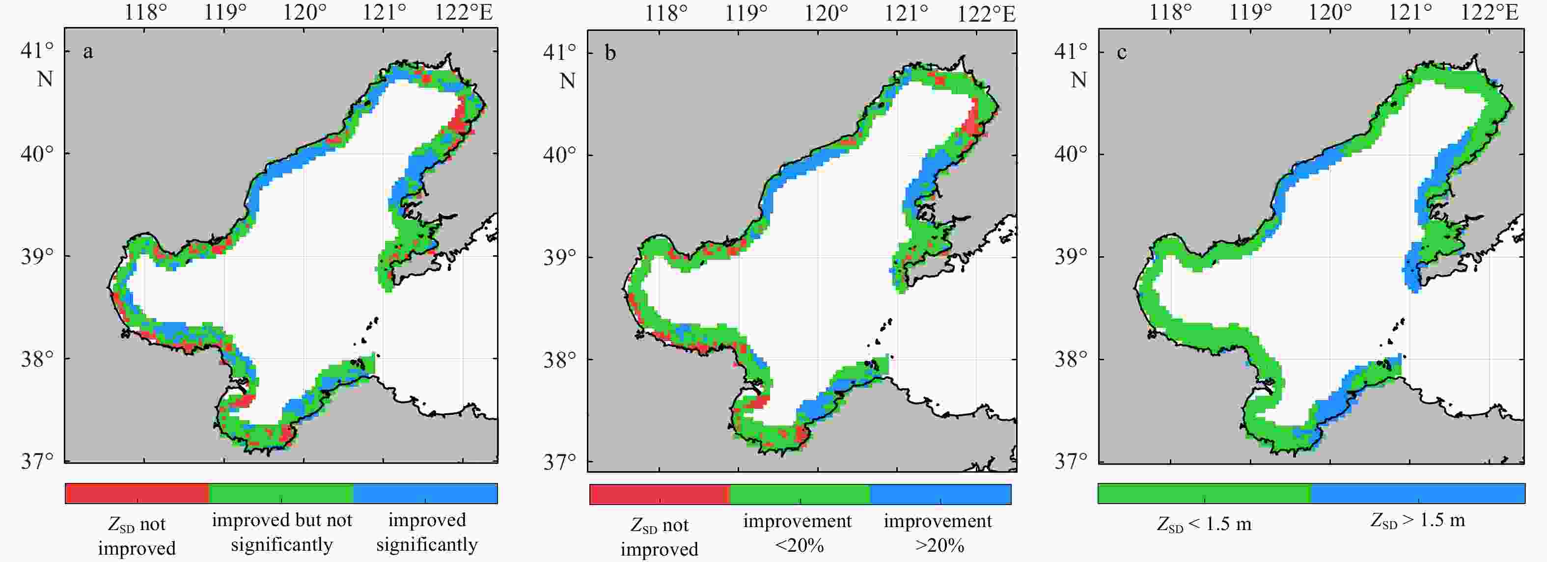
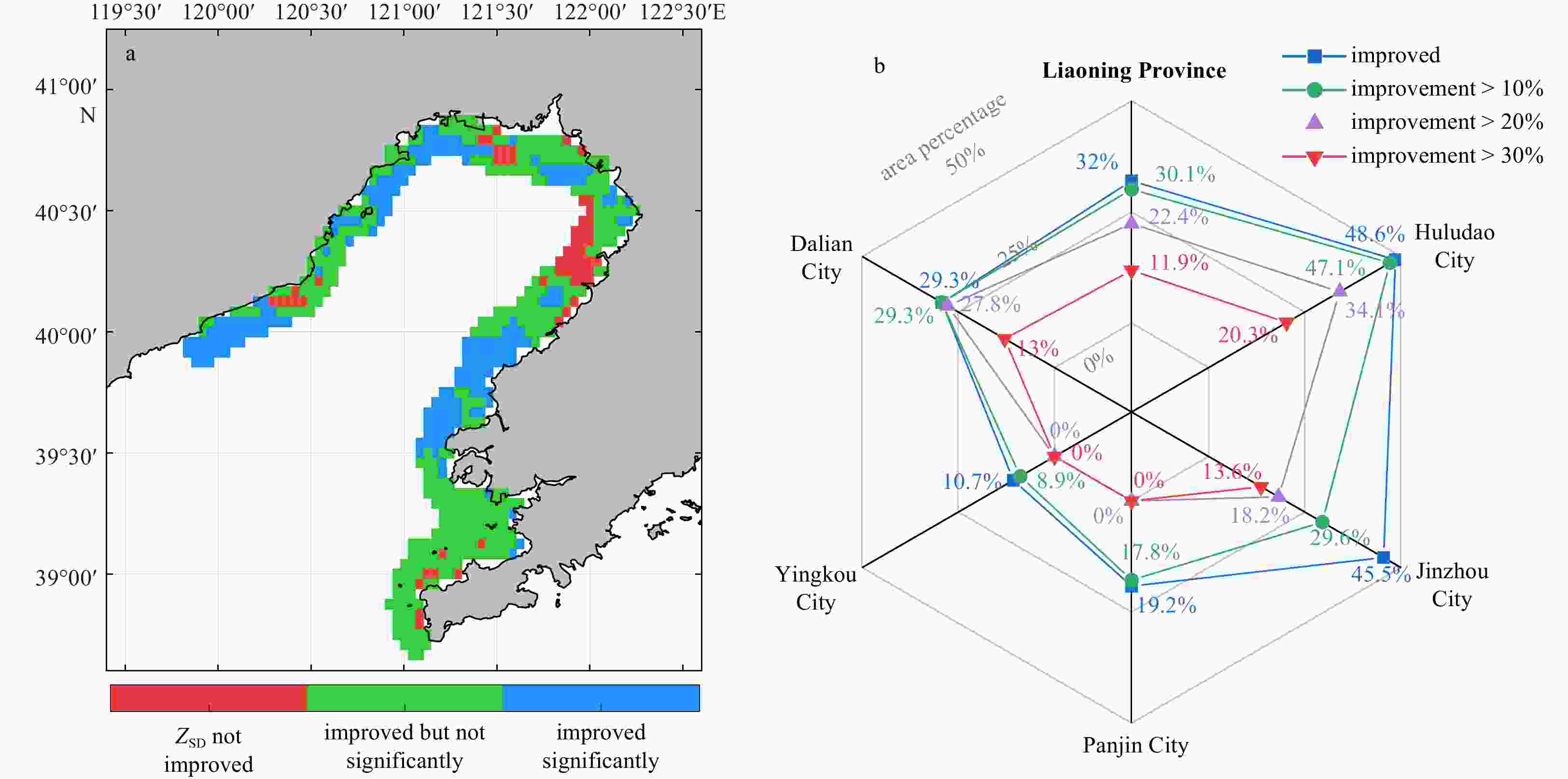
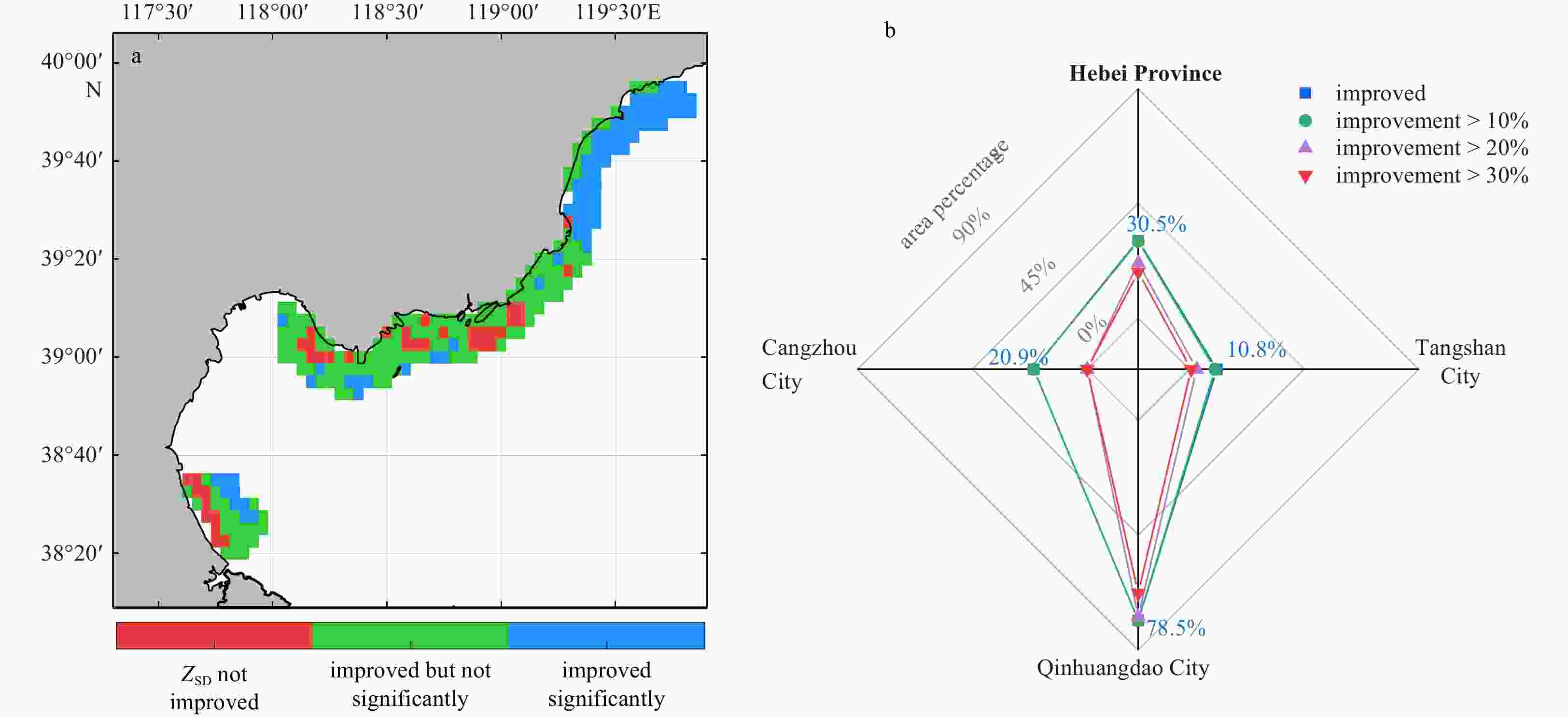
$\mathrm{Min}\left[{K}_{{\rm{d}}}\left({{\text{λ}} }_{1},{{\text{λ}} }_{2},{{\text{λ}} }_{3},\cdots \right)\right]$ represents the minimum at these bands and${R}_{{\rm{rs}}}^{{\rm{pc}}}$ is the remote sensing reflectance of the corresponding wavelength.Figure 6. Spatial distribution of ZSD variability over BS nearshore waters during 2018 and 2020, as compared to that during 2011 and 2017, ZSD improvement of Liaoning, Hebei, Shandong and Tianjin were 13.2% ± 11.6%, 13.2% ± 16.5%, 10.8% ± 10.2%, and 6.2% ± 4.7%, respectively (a); spatial distribution of nearshore waters during 2018 and 2020 with ZSD increase of higher than 20% (in blue) and lower than 20% (in green), respectively (b); and average ZSD during 2011 and 2017 (c). The “improved significantly” refers to ZSD improvement satisfying 95% significance level.
-
Alam W, Xu Xiangmin, Ahamed R. 2021. Protecting the marine and coastal water from land-based sources of pollution in the northern Bay of Bengal: a legal analysis for implementing a national comprehensive act. Environmental Challenges, 4: 100154. doi: 10.1016/j.envc.2021.100154 Alvera-Azcárate A, Barth A, Rixen M, et al. 2005. Reconstruction of incomplete oceanographic data sets using empirical orthogonal functions: application to the Adriatic Sea surface temperature. Ocean Modelling, 9(4): 325–346. doi: 10.1016/j.ocemod.2004.08.001 Bailey S W, Werdell P J. 2006. A multi-sensor approach for the on-orbit validation of ocean color satellite data products. Remote Sensing of Environment, 102(1/2): 12–23. doi: 10.1016/j.rse.2006.01.015 Beckers J M, Rixen M. 2003. EOF calculations and data filling from incomplete oceanographic datasets. Journal of Atmospheric and Oceanic Technology, 20(12): 1839–1856. doi: 10.1175/1520-0426(2003)020<1839:ECADFF>2.0.CO;2 Bulgarelli B, Zibordi G. 2018. On the detectability of adjacency effects in ocean color remote sensing of mid-latitude coastal environments by SeaWiFS, MODIS-A, MERIS, OLCI, OLI and MSI. Remote Sensing of Environment, 209: 423–438. doi: 10.1016/j.rse.2017.12.021 Caballero I, Morris E P, Ruiz J, et al. 2014. Assessment of suspended solids in the Guadalquivir estuary using new DEIMOS-1 medium spatial resolution imagery. Remote Sensing of Environment, 146: 148–158. doi: 10.1016/j.rse.2013.08.047 Chen Jun, Cui Tingwei, Tang Junwu, et al. 2014. Remote sensing of diffuse attenuation coefficient using MODIS imagery of turbid coastal waters: a case study in Bohai Sea. Remote Sensing of Environment, 140: 78–93. doi: 10.1016/j.rse.2013.08.031 Chen Xiaoling, Lu Jianzhong, Cui Tingwei, et al. 2010. Coupling remote sensing retrieval with numerical simulation for SPM study—Taking Bohai Sea in China as a case. International Journal of Applied Earth Observation and Geoinformation, 12 (Suppl 2): S203–S211, Chen Zhiqiang, Muller-Karger F E, Hu Chuanmin. 2007. Remote sensing of water clarity in Tampa Bay. Remote Sensing of Environment, 109(2): 249–259. doi: 10.1016/j.rse.2007.01.002 Chen Shuguo, Zhang Tinglu, Chen Wenzhong, et al. 2016. Instantaneous influence of dust storms on the optical scattering property of the ocean: a case study in the Yellow Sea, China. Optics Express, 24(25): 28509–28518. doi: 10.1364/OE.24.028509 Claustre H, Morel A, Hooker S B, et al. 2002. Is desert dust making oligotrophic waters greener?. Geophysical Research Letters, 29(10): 1469, Cui Tingwei, Zhang Jie, Groom S, et al. 2010. Validation of MERIS ocean-color products in the Bohai Sea: a case study for turbid coastal waters. Remote Sensing of Environment, 114(10): 2326–2336. doi: 10.1016/j.rse.2010.05.009 Ding Xiaosong, Gong Fang, Zhu Qiankun, et al. 2022. Using geostationary satellite ocean color data and superpixel to map the diurnal dynamics of water transparency in the eastern China seas. Ecological Indicators, 142: 109219. doi: 10.1016/j.ecolind.2022.109219 Doxaran D, Lamquin N, Park Y J, et al. 2014. Retrieval of the seawater reflectance for suspended solids monitoring in the East China Sea using MODIS, MERIS and GOCI satellite data. Remote Sensing of Environment, 146: 36–48. doi: 10.1016/j.rse.2013.06.020 Duan Hongtao, Zhang Yuanzhi, Zhang Bin, et al. 2008. Estimation of chlorophyll-a concentration and trophic states for inland lakes in Northeast China from Landsat TM data and field spectral measurements. International Journal of Remote Sensing, 29(3): 767–786. doi: 10.1080/01431160701355249 Ecological Environment Department, National Development and Reform Commission, Ministry of Natural Resources, People’s Republic of China. 2018. Notice of the MEE, NDRC, and MNR on printing and distributing the Uphill Battles for Integrated Bohai Sea Management (in Chinese). https://www.mee.gov.cn/xxgk2018/xxgk/xxgk03/201812/t20181211_684232.html[2018-12-11/2022-08-02] Ecological Environment Department, National Development and Reform Commission, Ministry of Natural Resources, People’s Republic of China, et al. 2022. Notice on printing and distributing the Action Plan for Uphill Battles for Integrated Key Sea Areas Management (in Chinese).https://www.mee.gov.cn/xxgk2018/xxgk/xxgk03/202202/t20220217_969303.html[2022-02-17/2022-08-01] Fei Zunle. 1986. Study on the water colour and transparency in the Bohai Sea. Journal of Oceanography of Huanghai & Bohai Seas (in Chinese), 4(1): 33–40 Gao Xuelu, Zhou Fengxia, Chen C T A. 2014. Pollution status of the Bohai Sea: an overview of the environmental quality assessment related trace metals. Environment International, 62: 12–30. doi: 10.1016/j.envint.2013.09.019 Gong Peng. 2012. Remote sensing of environmental change over China: a review. Chinese Science Bulletin, 57(22): 2793–2801. doi: 10.1007/s11434-012-5268-y Guo Zhigang, Yang Zuosheng, Fan Dejiang, et al. 2003. Seasonal variation of sedimentation in the Changjiang Estuary mud area. Journal of Geographical Sciences, 13(3): 348–354. doi: 10.1007/BF02837510 He Xianqiang, Pan Delu, Bai Yan, et al. 2017. Recent changes of global ocean transparency observed by SeaWiFS. Continental Shelf Research, 143: 159–166. doi: 10.1016/j.csr.2016.09.011 Kuhn C, de Matos Valerio A, Ward N, et al. 2019. Performance of Landsat-8 and Sentinel-2 surface reflectance products for river remote sensing retrievals of chlorophyll-a and turbidity. Remote Sensing of Environment, 224: 104–118. doi: 10.1016/j.rse.2019.01.023 Lee Z, Arnone R, Boyce D, et al. 2018. Global water clarity: continuing a century-long monitoring. Eos Transactions American Geophysical Union, 99, https://eos.org/opinions/global-water-clarity-continuing-a-century-long-monitoring[2018-05-07/2022-08-01] Lee Z, Carder K L, Arnone R A. 2002. Deriving inherent optical properties from water color: a multiband quasi-analytical algorithm for optically deep waters. Applied Optics, 41(27): 5755–5772. doi: 10.1364/ao.41.005755 Lee Z P, Du Keping, Arnone R. 2005. A model for the diffuse attenuation coefficient of downwelling irradiance. Journal of Geophysical Research: Oceans, 110(C2): C02016. doi: 10.1029/2004JC002275 Lee Z, Shang Shaoling, Hu Chuanmin, et al. 2015. Secchi disk depth: a new theory and mechanistic model for underwater visibility. Remote Sensing of Environment, 169: 139–149. doi: 10.1016/j.rse.2015.08.002 Lee Z, Shang Shaoling, Qi Lin, et al. 2016. A semi-analytical scheme to estimate Secchi-disk depth from Landsat-8 measurements. Remote Sensing of Environment, 177: 101–106. doi: 10.1016/j.rse.2016.02.033 Li Peng, Chen Shenliang, Ke Yinghai, et al. 2022. Spatiotemporal dynamics of suspended particulate matter in the Bohai Sea, China over the past decade from the space perspective. Science of the Total Environment, 851: 158210. doi: 10.1016/j.scitotenv.2022.158210 Li Jin, Hao Yanling, Zhang Zhuangzhuang, et al. 2021. Analyzing the distribution and variation of Suspended Particulate Matter (SPM) in the Yellow River Estuary (YRE) using Landsat 8 OLI. Regional Studies in Marine Science, 48: 102064. doi: 10.1016/j.rsma.2021.102064 Li Wenjian, Wang Zhenyan, Huang Haijun. 2020. Indication of size distribution of suspended particulate matter for sediment transport in the South Yellow Sea. Estuarine, Coastal and Shelf Science, 235: 106619, Ling Xin, Han Xue. 2021. Research on the pollution prevention and control mechanism of watershed-estuary-coastal waters of Bohai Sea. Marine Environmental Science (in Chinese), 40(6): 970–974, 980. doi: 10.13634/j.cnki.mes.2021.06.023 Liu Xianfu, Meng Xuejiao, Wang Xiaoyong, et al. 2020. Using a semi-analytical model to retrieve Secchi depth in coastal and estuarine waters. Acta Oceanologica Sinica, 39(8): 103–112. doi: 10.1007/s13131-020-1620-2 Mao Ying, Wang Shengqiang, Qiu Zhongfeng, et al. 2018. Variations of transparency derived from GOCI in the Bohai Sea and the Yellow Sea. Optics Express, 26(9): 12191–12209. doi: 10.1364/OE.26.012191 McClain C R. 2009. A decade of satellite ocean color observations. Annual Review of Marine Science, 1: 19–42. doi: 10.1146/annurev.marine.010908.163650 Pan Delu, Bai Yan. 2008. Progress in the application of ocean color remote sensing in China. Acta Oceanologica Sinica, 27(4): 1–16 Pan Xiaobin, Du Boyang. 2022. Research on legal path of pollution prevention and control in the Bohai Sea in China. Tianjin Legal Science (in Chinese), 38(1): 5–13 Pan Delu, Mao Zhihua. 2001. Atmospheric correction for China’s coastal water color remote sensing. Acta Oceanologica Sinica, 20(3): 343–354 Pan Delu, Mao Tianming, Li Shujing, et al. 2001. Study on detection of coastal water environment of China by ocean color remote sensing. Acta Oceanologica Sinica, 20(1): 51–63 Preisendorfer R W. 1986. Secchi disk science: visual optics of natural waters. Limnology and Oceanography, 31(5): 909–926. doi: 10.4319/lo.1986.31.5.0909 Qing Song, Zhang Jie, Cui Tingwei, et al. 2012. Remote sensing retrieval of total absorption coefficient in the Bohai Sea. Chinese Journal of Oceanology and Limnology, 30(5): 806–813. doi: 10.1007/s00343-012-1238-0 Shen Fang, Zhou Yunxuan, Peng Xiangyi, et al. 2014. Satellite multi-sensor mapping of suspended particulate matter in turbid estuarine and coastal ocean, China. International Journal of Remote Sensing, 35(11/12): 4173–4192, Shi Kun, Zhang Yunlin, Zhu Guangwei, et al. 2018. Deteriorating water clarity in shallow waters: evidence from long term MODIS and in-situ observations. International Journal of Applied Earth Observation and Geoinformation, 68: 287–297. doi: 10.1016/j.jag.2017.12.015 Song Jianing. 2017. Thoughts on ecological environmental governance of circum-Bohai Sea region. China Development (in Chinese), 17(5): 7–12. doi: 10.15885/j.cnki.cn11-4683/z.2017.05.003 Tan Saichun, Shi Guangyu, Wang Hong. 2012. Long-range transport of spring dust storms in Inner Mongolia and impact on the China seas. Atmospheric Environment, 46: 299–308. doi: 10.1016/j.atmosenv.2011.09.058 Tavora J, Boss E, Doxaran D, et al. 2020. An algorithm to estimate suspended particulate matter concentrations and associated uncertainties from remote sensing reflectance in coastal environments. Remote Sensing, 12(13): 2172. doi: 10.3390/rs12132172 Wang Shenglei, Lee Z, Shang Shaoling, et al. 2019. Deriving inherent optical properties from classical water color measurements: Forel-Ule index and Secchi disk depth. Optics Express, 27(5): 7642–7655. doi: 10.1364/OE.27.007642 Wei Fengying. 2007. Technology of Contemporary Climatic Statistics, Diagnosis and Prediction (in Chinese). 2nd ed. Beijing: China Meteorological Press Xiang Jinzhao, Cui Tingwei, Qing Song, et al. 2023. Remote sensing retrieval of water clarityinclear oceanic toextremely turbidcoastal waters frommultiple spaceborne sensors. IEEE Transactions on Geoscience and Remote Sensing, 61: 1−18. Xue Yuhuan, Xiong Xuejun, Liu Yanqing. 2015. Distribution features and seasonal variability of the transparency in offshore waters of China. Advances in Marine Science (in Chinese), 33(1): 38–44 Ye Han, Shi Yueshuang, Liang Hanwei, et al. 2022. Spatiotemporal characteristics and driving factors of water transparency in the South Yellow Sea. Haiyang Xuebao (in Chinese), 44(3): 128–136 Yin Ziyao, Jiang Tao, Yang Guangpu, et al. 2020. The spatial-temporal variation of water clarity and its influencing factors in Jiaozhou Bay from 1986 to 2017. Marine Sciences (in Chinese), 44(4): 21–32 Yin Ziyao, Li Junsheng, Liu Yao, et al. 2021. Water clarity changes in Lake Taihu over 36 years based on Landsat TM and OLI observations. International Journal of Applied Earth Observation and Geoinformation, 102: 102457. doi: 10.1016/j.jag.2021.102457 Zeng Shuai, Lei Shaohua, Li Yunmei, et al. 2020. Retrieval of secchi disk depth in turbid lakes from GOCI based on a new semi-analytical algorithm. Remote Sensing, 12(9): 1516. doi: 10.3390/rs12091516 Zhang Minwei, Dong Qing, Cui Tingwei, et al. 2015. Remote sensing of spatiotemporal variation of apparent optical properties in Bohai Sea. IEEE Journal of Selected Topics in Applied Earth Observations and Remote Sensing, 8(3): 1176–1184. doi: 10.1109/JSTARS.2014.2380785 Zhang Lei, Li Guangxue, Liu Xue, et al. 2020. Spatial and temporal changes of the Bohai Sea coastline. Marine Geology Frontiers (in Chinese), 36(2): 1–11. doi: 10.16028/j.1009-2722.2019.064 Zhao Gaibo, Jiang Wensheng, Wang Tao, et al. 2022. Decadal variation and regulation mechanisms of the suspended sediment concentration in the Bohai Sea, China. Journal of Geophysical Research: Oceans, 127(3): e2021JC017699. doi: 10.1029/2021JC017699 Zhao Kaiguang, Wulder M A, Hu Tongxi, et al. 2019. Detecting change-point, trend, and seasonality in satellite time series data to track abrupt changes and nonlinear dynamics: a Bayesian ensemble algorithm. Remote Sensing of Environment, 232: 111181. doi: 10.1016/j.rse.2019.04.034 Zhu Lanbu, Zhao Baoren. 1991. Distributions and variations of the transparency in the Bohai Sea, Yellow Sea and East China Sea. Transactions of Oceanology and Limnology (in Chinese), (3): 1–11. doi: 10.13984/j.cnki.cn37-1141.1991.03.001 -


 下载:
下载:
