

-
Abstract: The snow depth on sea ice is an extremely critical part of the cryosphere. Monitoring and understanding changes of snow depth on Antarctic sea ice is beneficial for research on sea ice and global climate change. The Microwave Radiation Imager (MWRI) sensor aboard the Chinese FengYun-3D (FY-3D) satellite has great potential for obtaining information of the spatial and temporal distribution of snow depth on the sea ice. By comparing in-situ snow depth measurements during the 35th Chinese Antarctic Research Expedition (CHINARE-35), we took advantage of the combination of multiple gradient ratio (GR (36V, 10V) and GR (36V, 18V)) derived from the measured brightness temperature of FY-3D MWRI to estimate the snow depth. This method could simultaneously introduce the advantages of high and low GR in the snow depth retrieval model and perform well in both deep and shallow snow layers. Based on this, we constructed a novel model to retrieve the FY-3D MWRI snow depth on Antarctic sea ice. The new model validated by the ship-based observational snow depth data from CHINARE-35 and the snow depth measured by snow buoys from the Alfred Wegener Institute (AWI) suggest that the model proposed in this study performs better than traditional models, with root mean square deviations (RMSDs) of 8.59 cm and 7.71 cm, respectively. A comparison with the snow depth measured from Operation IceBridge (OIB) project indicates that FY-3D MWRI snow depth was more accurate than the released snow depth product from the U.S. National Snow and Ice Data Center (NSIDC) and the National Tibetan Plateau Data Center (NTPDC). The spatial distribution of the snow depth from FY-3D MWRI agrees basically with that from ICESat-2; this demonstrates its reliability for estimating Antarctic snow depth, and thus has great potential for understanding snow depth variations on Antarctic sea ice in the context of global climate change.
-
Key words:
- snow depth /
- Antarctic sea ice /
- passive microwave /
- FY-3D
-

Figure 1. The distributions of ship routes during CHINARE-35 (blue line), the ship-based observational snow depth (red dots), Alfred Wegener Institute (AWI) snow buoy (orange line) and Operation IceBridge (OIB) airborne measurements (green line) (a) and snow depth estimation involving photogrammetric images (b). The long red line in b denotes the reference ball diameter, the short red lines denote snow depth on sea ice.
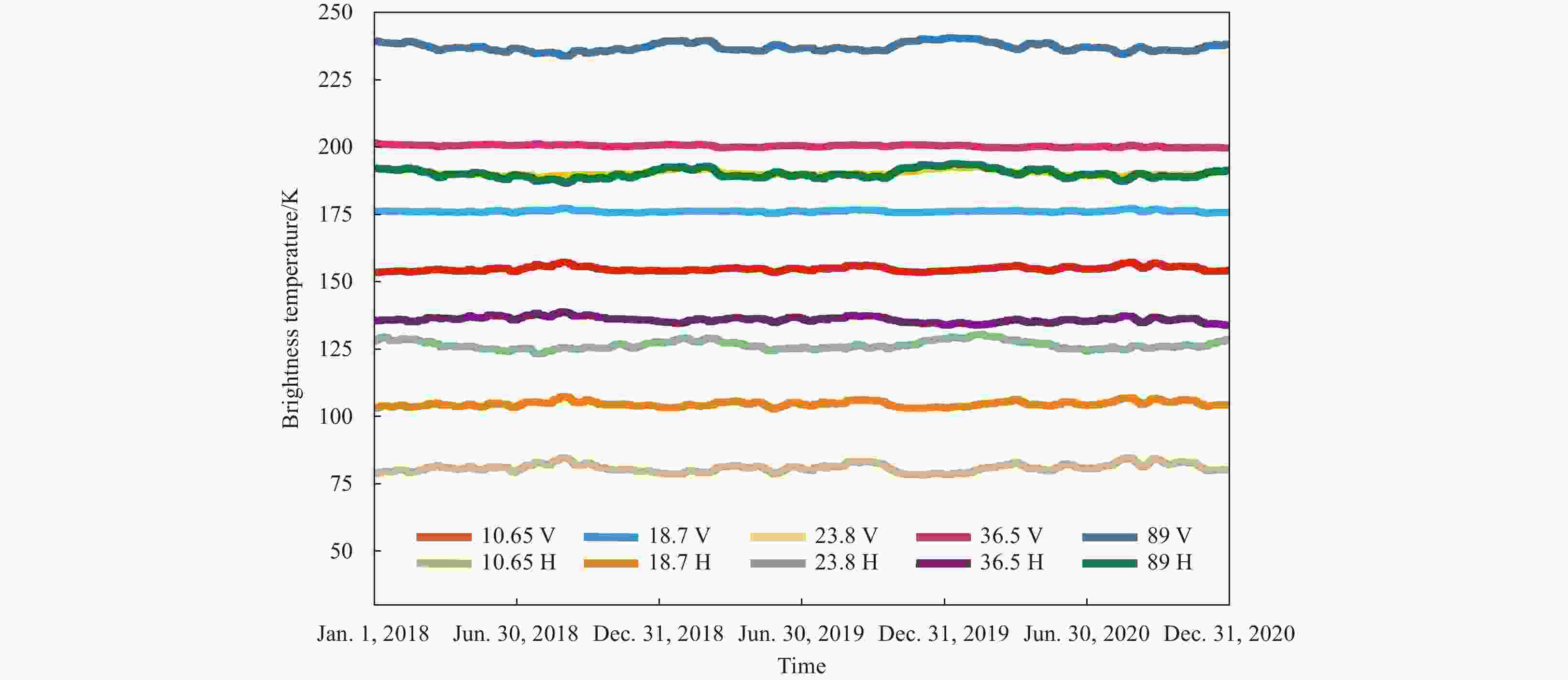
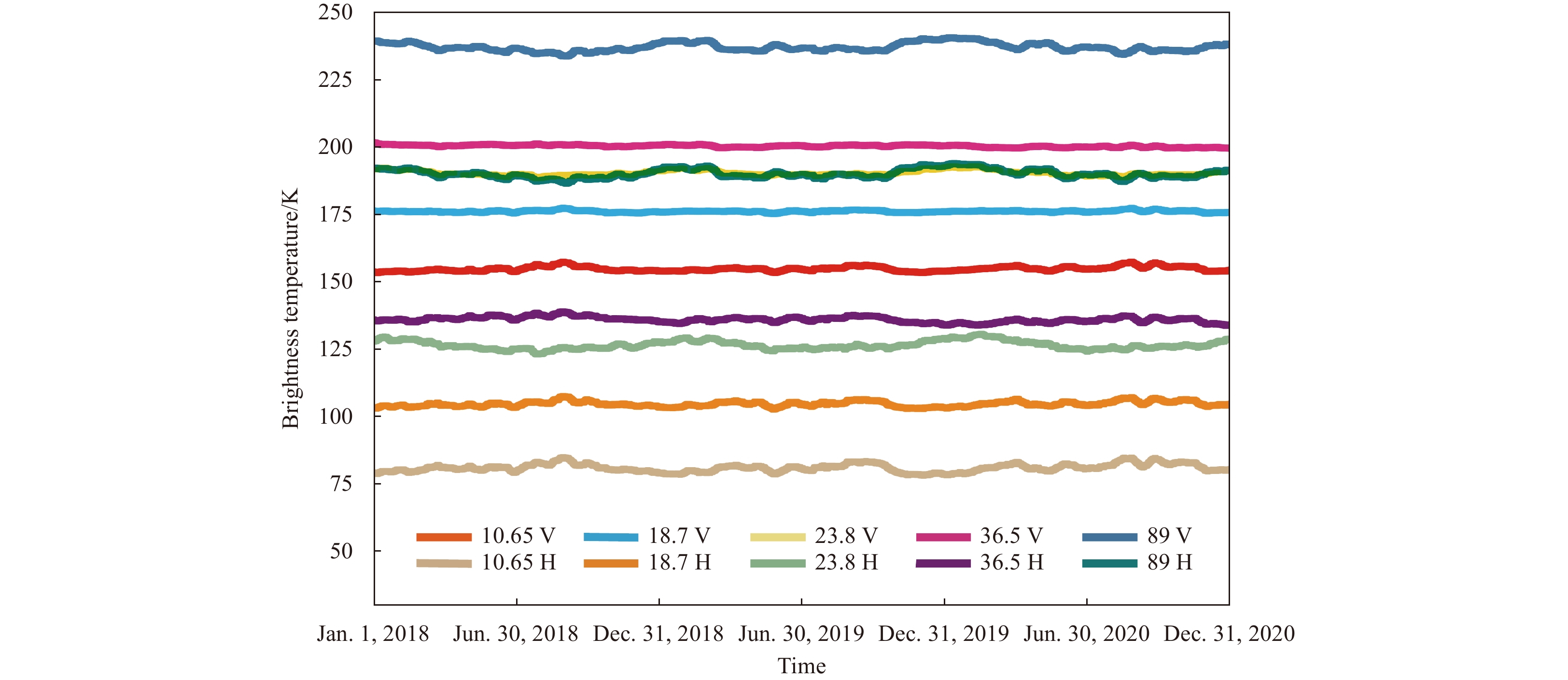
Figure 2. Daily TB of FY-3D MWRI at different frequency time bands in open water from 2018 to 2020.
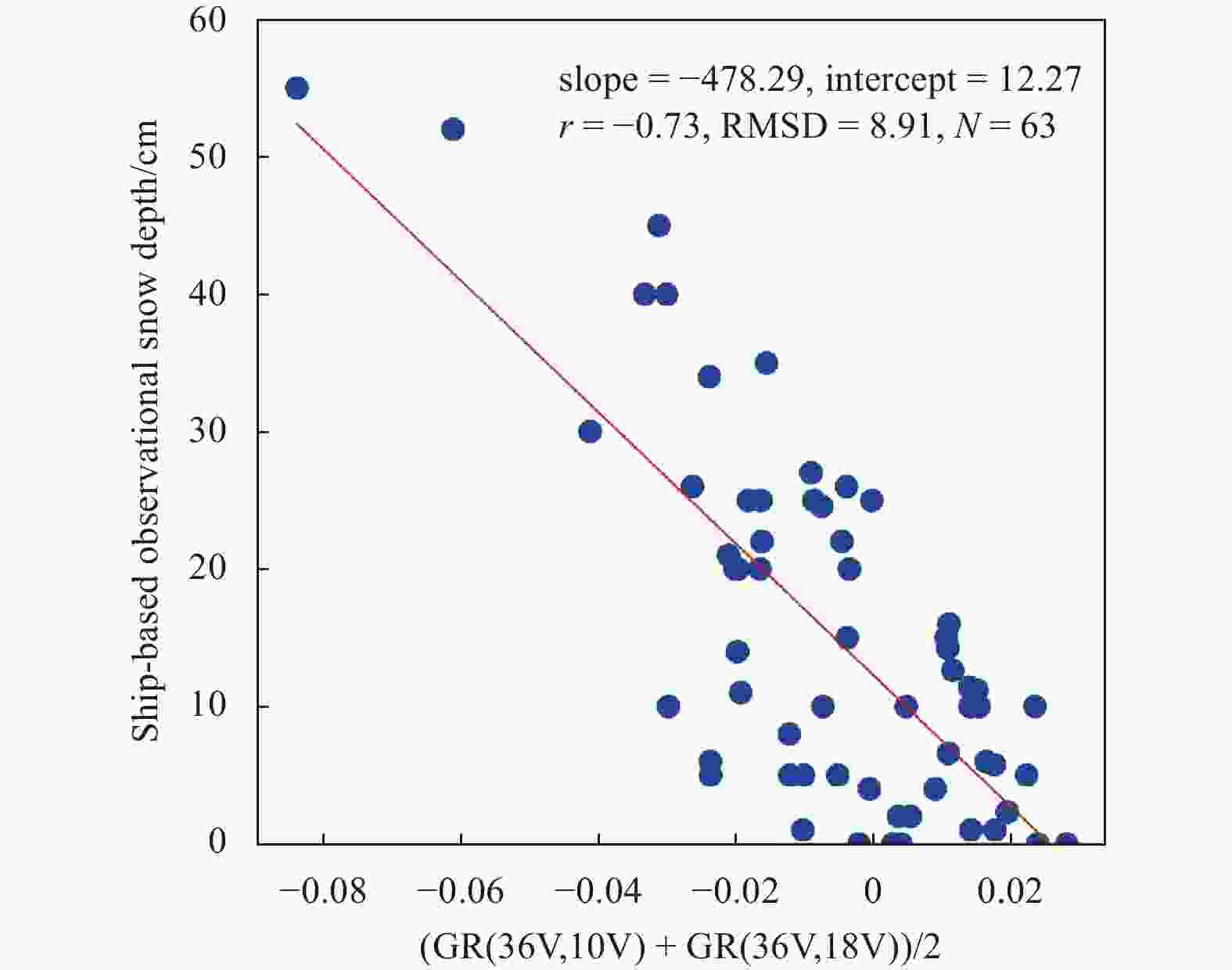
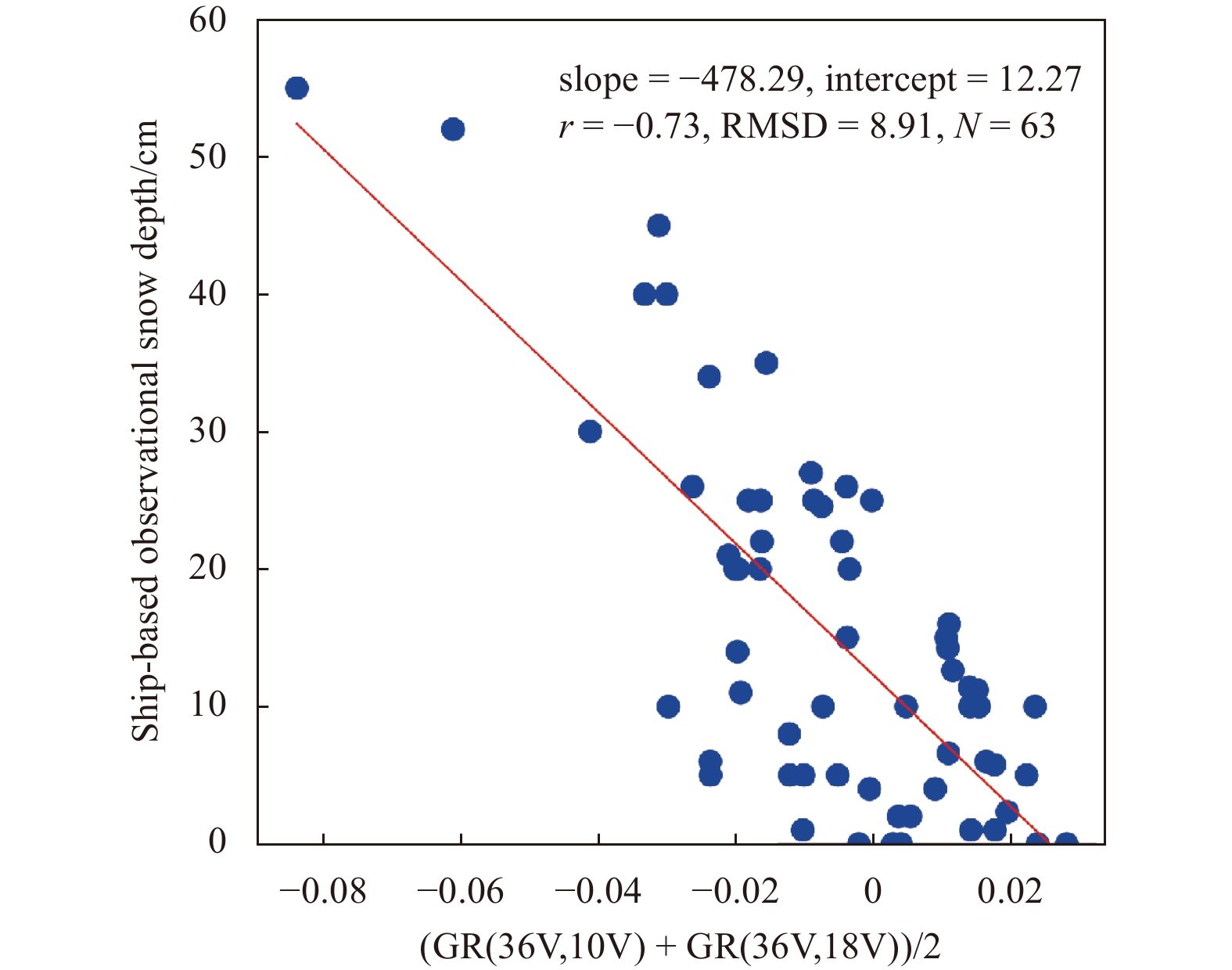
Figure 3. The scatter diagram between ship-based observational snow depth and combined gradient radio derived from FY-3D MWRI data.
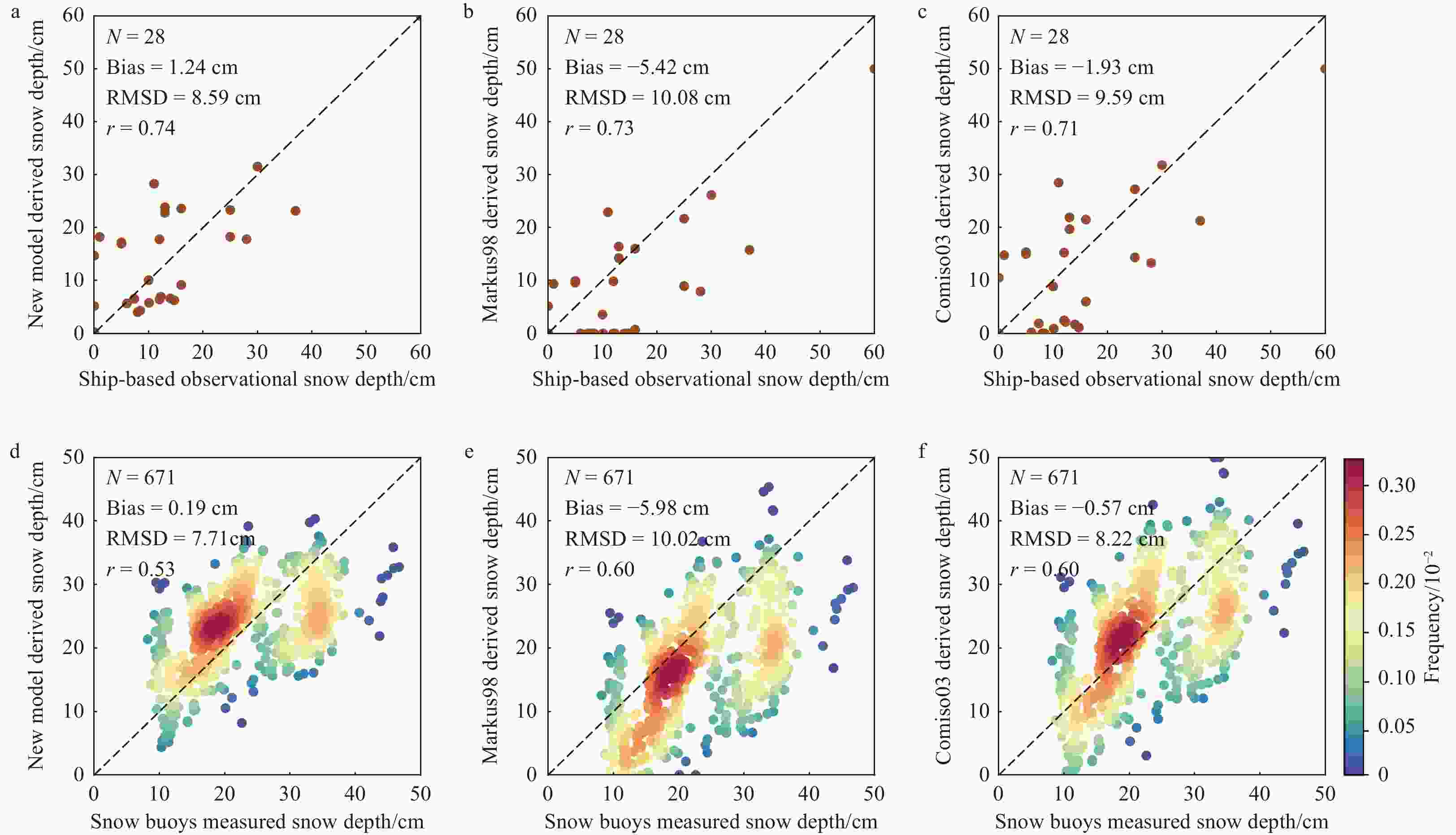
Figure 4. Comparisons of ship-based observational snow depth to the snow depth estimates based on the proposed model (a), Markus98 model (b) and Comiso03 model (c), and comparisons of AWI snow buoy data to the snow depth estimates based on the proposed model (d), Markus98 model (e) and Comiso03 model (f). The color bar represents the density of the points.
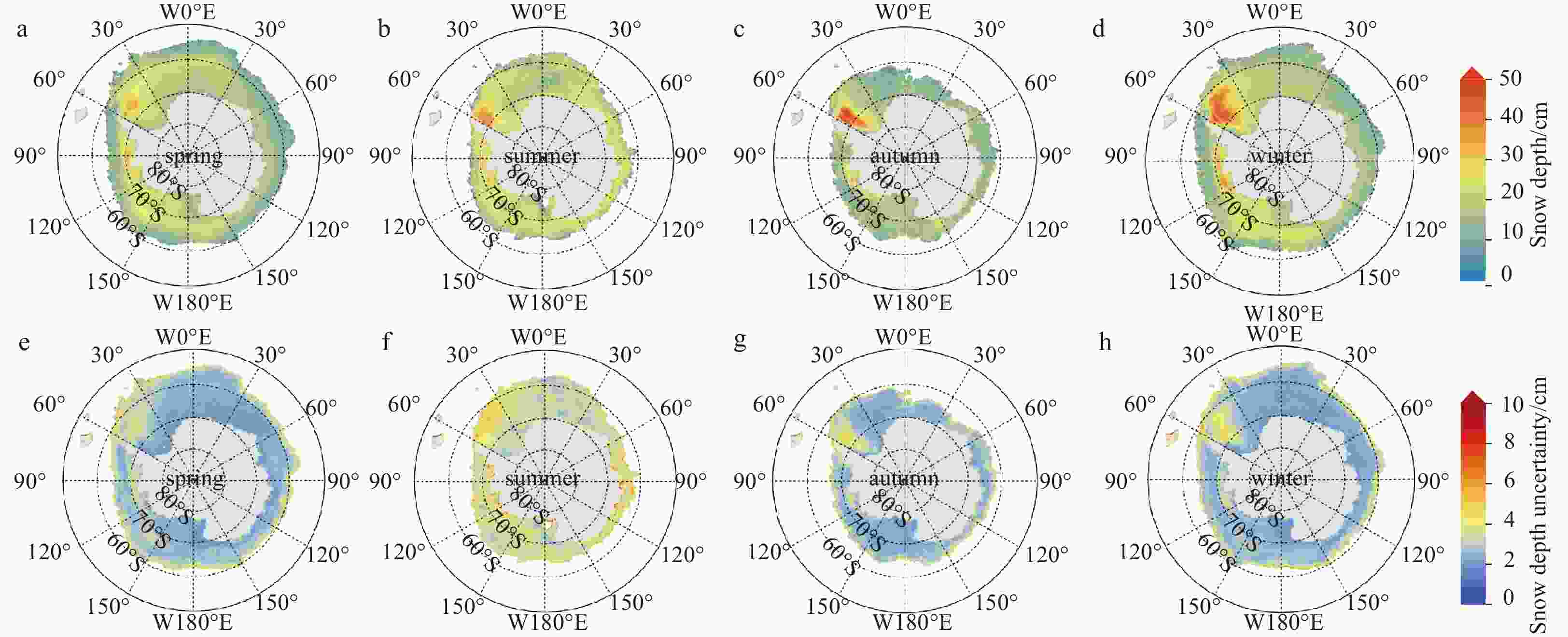
Figure 5. The spatial distributions of averaged snow depth on Antarctic sea ice in different seasons (a–d) with its uncertainty (e–h) from 2018 to 2020. Spring: September–November, Summer: December–February, Autumn: March–May and Winter: June–August.
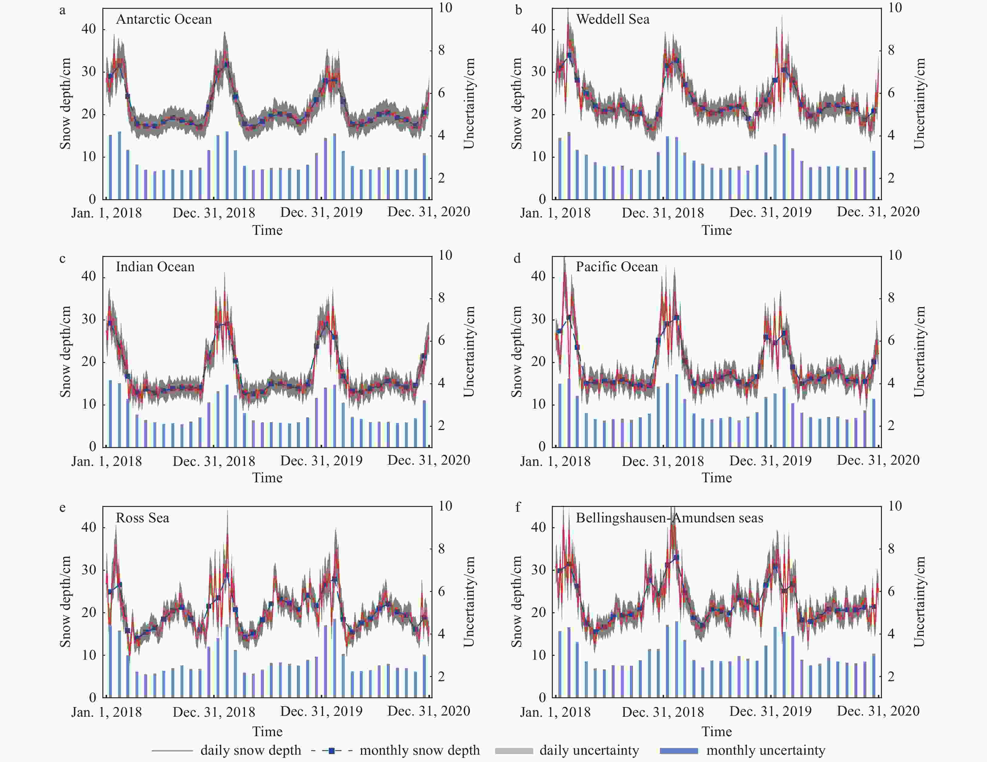
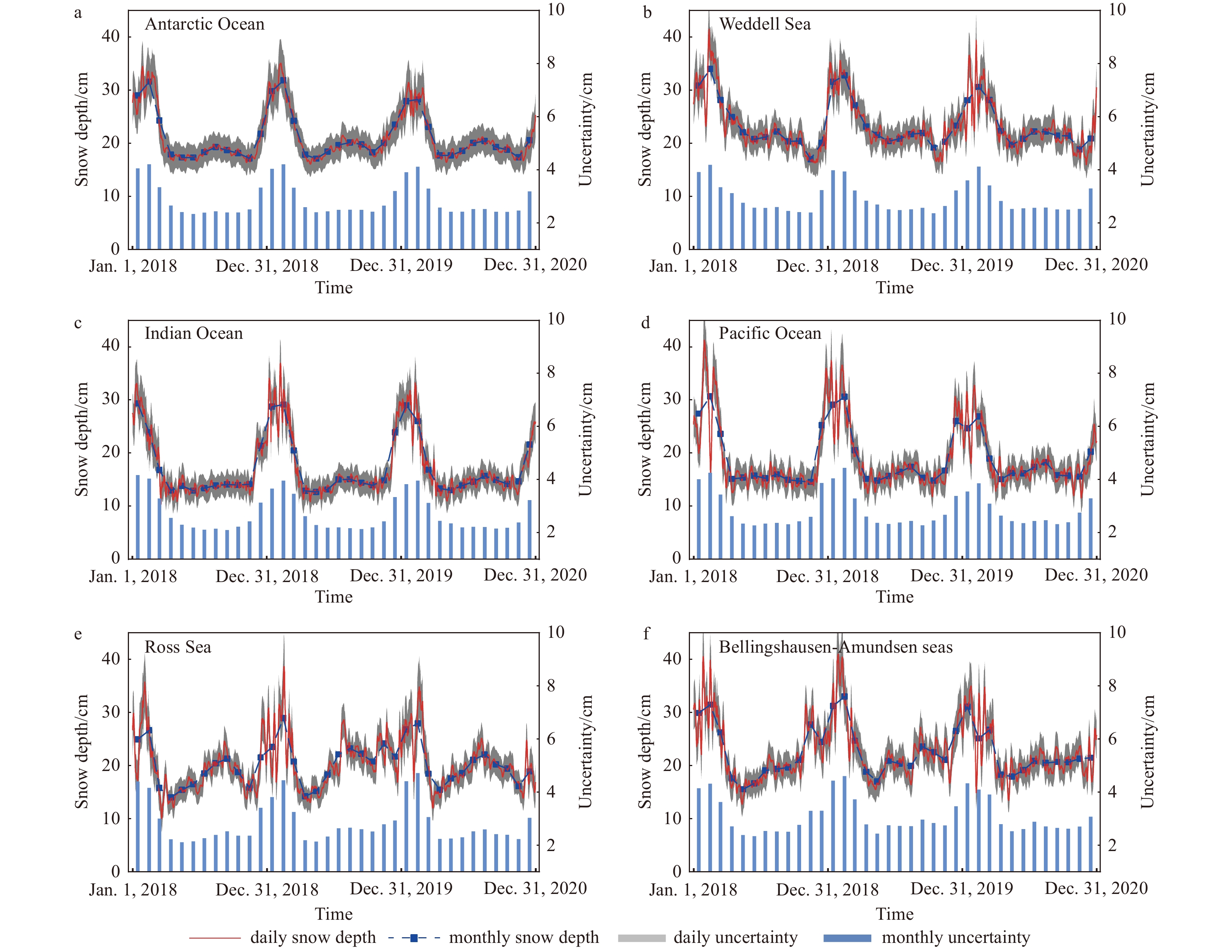
Figure 6. Time series of snow depth with its uncertainty in Antarctic Ocean (a), Weddell Sea: 60°W–20°E (b), Indian Ocean: 20°–90°E (c), Pacific Ocean: 90°–160°E (d), Ross Sea: 160°E–130°W (e) and Bellingshausen-Amundsen seas: 130°–60°W (f) from 2018 to 2020.

Figure 7. Comparison of FY-3D MWRI snow depth, NSIDC-AMSR2 SD and NTPDC-AMSR2 SD in the Antarctic and five seas from 2018 to 2019 for the statistic index of mean difference (a), mean absolute difference (b), standard deviation (c), and correlation coefficient (d).
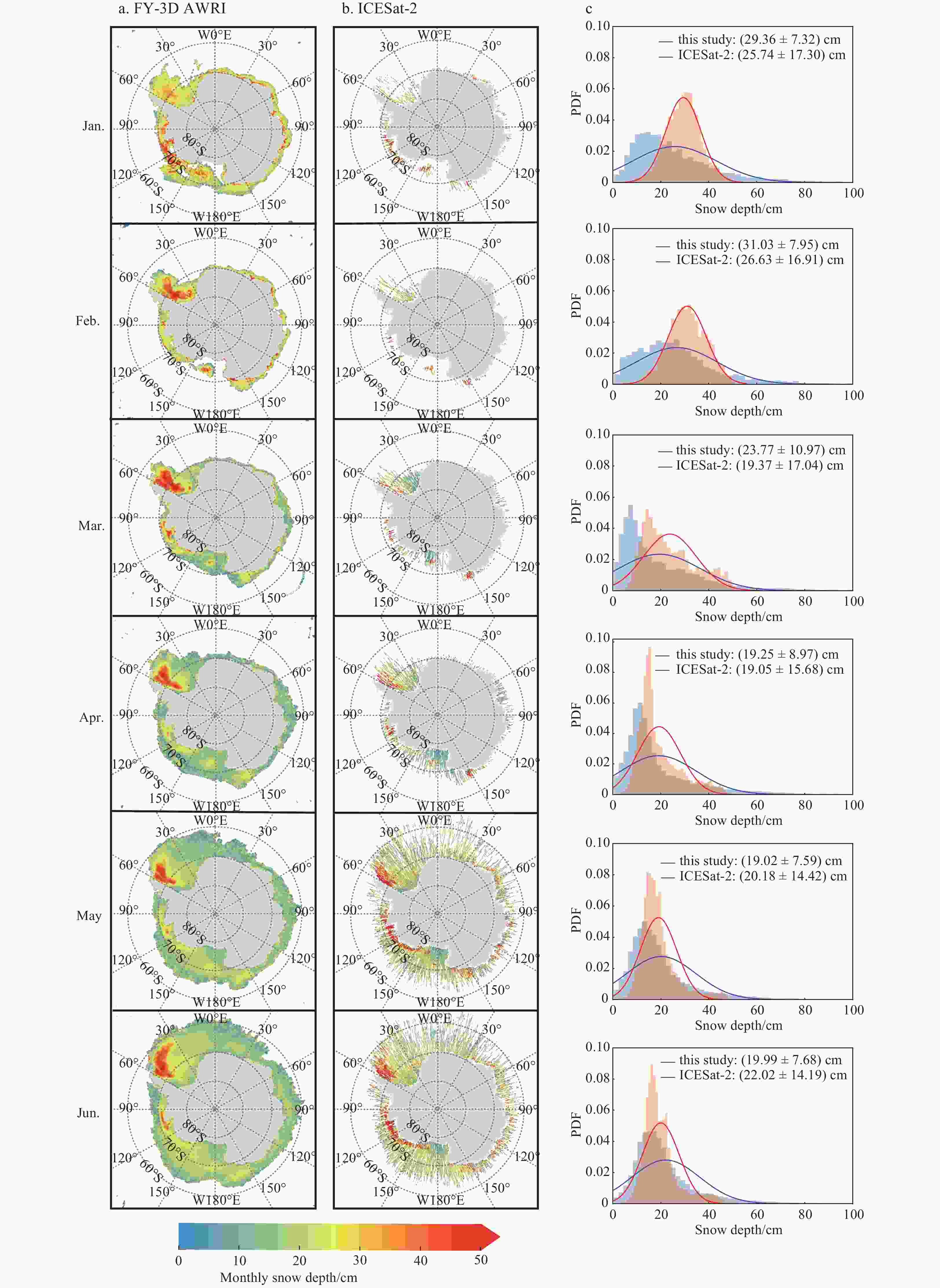
Figure 8. The spatial distributions of monthly snow depth (January to June 2020) derived from FY-3D MWRI (a) and ICESat-2 (b), with the probability density functions (PDFs) (c) from FY-3D MWRI (red line) and ICESat-2 (blue line) in the common area.
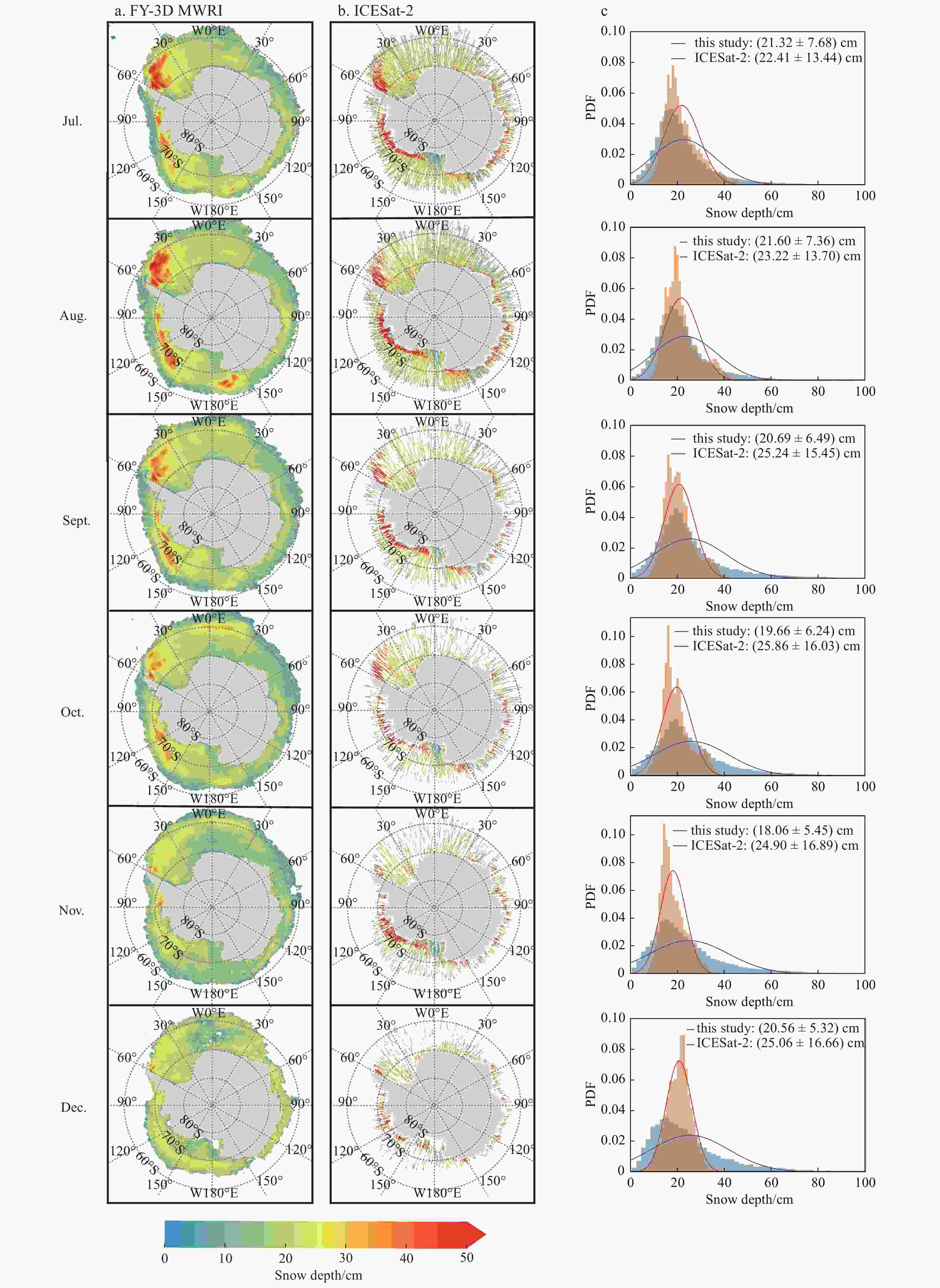
Figure 9. The spatial distributions of monthly snow depth (July to December 2020) derived from FY-3D MWRI (a) and ICESat-2 (b), with the probability density functions (PDFs) (c) from FY-3D MWRI (red line) and ICESat-2 (blue line) in the common area.
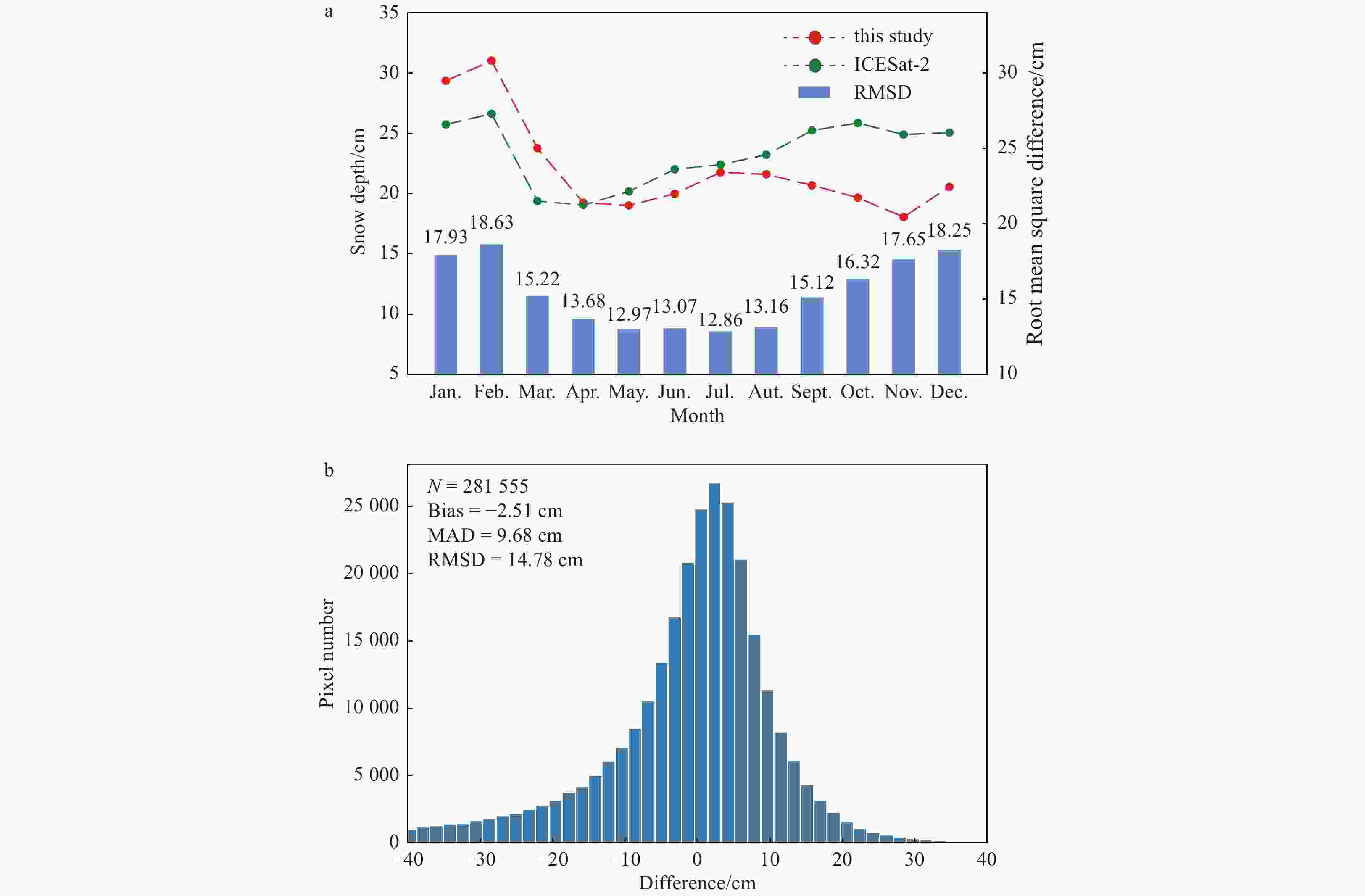
Figure 10. Time series of FY-3D MWRI snow depth and ICESat-2 snow depth from January to December 2020 (a), and the difference between FY-3D MWRI snow depth and ICESat-2 snow depth from January to December 2020 (b).
Table 1. Summary of snow depth from this study, NSIDC and NTPDC
Source Sensor Period Spatial resolution/km Modeling bands This study MWRI 2018–2020 12.5 10.65 GHz, 18.7 GHz, 36.5 GHz NSIDC AMSR2 2012 to now 12.5 18.7 GHz, 36.5 GHz NTPDC SSMIS, AMSR-E, AMSR2 2002–2020 25.0 6.9 GHz (19.35 GHz), 36.5 GHz  下载: 导出CSV
Table 2. The correlation coefficient and RMSD between the ship-based observational snow depth and different GRs derived from FY-3D MWRI
GR Correlation coefficient RMSD/cm GR Correlation coefficient RMSD/cm GR(18V, 10V) –0.66 9.95 GR(18H, 10H) –0.62 10.43 GR(23V, 10V) –0.63 10.34 GR(23H, 10H) –0.57 10.96 GR(36V, 10V) –0.72 9.06 GR(36H, 10H) –0.69 9.65 GR(23V, 18V) –0.49 11.60 GR(23H, 18H) –0.41 12.14 GR(36V, 18V) –0.73 8.95 GR(36H, 18H) –0.70 9.54 GR(36V, 23V) –0.70 9.50 GR(36H, 23H) –0.60 10.62 (GR(36V, 10V) + GR(36V, 18V))/2 –0.73 8.91
下载: 导出CSV
Table 3. Differences between FY-3D MWRI snow depth, NSIDC-AMSR2 SD and NTPDC-AMSR2 SD in the Antarctic and five seas from 2018 to 2019
Region Dataset comparison Bias/cm MAD/cm STD/cm Correlation coefficient Antarctic this study vs. NSIDC 4.27 5.58 6.42 0.83 this study vs. NTPDC –9.86 10.35 5.68 0.84 Weddell Sea this study vs. NSIDC 3.28 5.06 6.03 0.90 this study vs. NTPDC –9.84 10.26 5.34 0.87 Indian Ocean this study vs. NSIDC 5.92 6.36 5.79 0.52 this study vs. NTPDC –9.21 9.67 4.97 0.70 Pacific Ocean this study vs. NSIDC 5.83 6.77 7.64 0.54 this study vs NTPDC –10.05 10.81 6.81 0.74 Ross Sea this study vs. NSIDC 4.41 5.29 5.86 0.80 this study vs. NTPDC –9.81 10.25 5.38 0.80 Bellingshausen-Amundsen seas this study vs. NSIDC 3.24 5.51 7.46 0.82 this study vs. NTPDC –10.69 11.30 6.90 0.83
下载: 导出CSV
Table 4. The comparisons between the OIB snow depth and FY-3D MWRI snow depth, NSIDC-AMSR2 SD, NTPDC-AMSR2 SD
Region snow depth dataset Pixel number Bias/cm MAD/cm RMSD/cm Correlation coefficient All this study 431 –4.17 11.52 15.10 0.46 NSIDC 431 –3.58 11.79 15.70 0.50 NTPDC 431 6.14 13.22 16.93 0.45 Weddell Sea this study 279 –4.76 8.24 10.78 0.65 NSIDC 279 –4.61 8.02 10.82 0.66 NTPDC 279 4.61 9.39 10.90 0.63 Bellingshausen-Amundsen Sea this study 81 12.42 14.49 17.78 0.26 NSIDC 81 15.23 16.73 20.06 0.08 NTPDC 81 25.73 27.22 30.30 0.14 East Antarctic this study 71 –20.78 21.05 23.81 0.27 NSIDC 71 –20.98 20.98 24.02 0.38 NTPDC 71 –10.18 12.29 15.02 0.39
下载: 导出CSV
-
Arndt S, Willmes S, Dierking W, et al. 2016. Timing and regional patterns of snowmelt on Antarctic sea ice from passive microwave satellite observations. Journal of Geophysical Research: Oceans, 121(8): 5916–5930. doi: 10.1002/2015JC011504 Bagnardi M, Kurtz N T, Petty A A, et al. 2021. Sea surface height anomalies of the Arctic Ocean from ICESat-2: a first examination and comparisons with CryoSat-2. Geophysical Research Letters, 48(14): e2021GL093155. doi: 10.1029/2021GL093155 Braakmann-Folgmann A, Donlon C. 2019. Estimating snow depth on Arctic sea ice using satellite microwave radiometry and a neural network. The Cryosphere, 13(9): 2421–2438. doi: 10.5194/tc-13-2421-2019 Brock J C, Wright C W, Sallenger A H, et al. 2002. Basis and methods of NASA airborne topographic mapper lidar surveys for coastal studies. Journal of Coastal Research, 18(1): 1–13 Brucker L, Markus T. 2013. Arctic-scale assessment of satellite passive microwave-derived snow depth on sea ice using Operation IceBridge airborne data. Journal of Geophysical Research: Oceans, 118(6): 2892–2905. doi: 10.1002/jgrc.20228 Comiso J C, Cavalieri D J, Markus T. 2003. Sea ice concentration, ice temperature, and snow depth using AMSR-E data. IEEE Transactions on Geoscience and Remote Sensing, 41(2): 243–252. doi: 10.1109/TGRS.2002.808317 Comiso J C, Kwok R, Martin S, et al. 2011. Variability and trends in sea ice extent and ice production in the Ross Sea. Journal of Geophysical Research: Oceans, 116(C4): C04021. doi: 10.1029/2010JC006391 Giles K A, Laxon S W, Wingham D J, et al. 2007. Combined airborne laser and radar altimeter measurements over the Fram Strait in May 2002. Remote Sensing of Environment, 111(2/3): 182–194. doi: 10.1016/j.rse.2007.02.037 Ivanova N, Pedersen L T, Tonboe R T, et al. 2015. Inter-comparison and evaluation of sea ice algorithms: towards further identification of challenges and optimal approach using passive microwave observations. The Cryosphere, 9(5): 1797–1817. doi: 10.5194/tc-9-1797-2015 Jackson K, Wilkinson J, Maksym T, et al. 2013. A novel and Low-Cost Sea Ice mass balance buoy. Journal of Atmospheric and Oceanic Technology, 30(11): 2676–2688. doi: 10.1175/JTECH-D-13-00058.1 Kacimi S, Kwok R. 2020. The Antarctic sea ice cover from ICESat-2 and CryoSat-2: freeboard, snow depth, and ice thickness. The Cryosphere, 14(12): 4453–4474. doi: 10.5194/tc-14-4453-2020 Kennicutt M C, Chown S L, Cassano J J, et al. 2014. Polar research: six priorities for Antarctic science. Nature, 512(7512): 23–25. doi: 10.1038/512023a Kern S, Ozsoy B. 2019. An attempt to improve snow depth retrieval using satellite microwave radiometry for rough Antarctic Sea Ice. Remote Sensing, 11(19): 2323. doi: 10.3390/rs11192323 Kern S, Ozsoy-Cicek B, Willmes S, et al. 2011. An intercomparison between AMSR-E snow-depth and satellite C-and Ku-band radar backscatter data for Antarctic sea ice. Annals of Glaciology, 52(57): 279–290. doi: 10.3189/172756411795931750 Kern S, Ozsoy-Çiçek B. 2016. Satellite remote sensing of snow depth on Antarctic Sea Ice: an inter-comparison of two empirical approaches. Remote Sensing, 8(6): 450. doi: 10.3390/rs8060450 Kern S, Spreen G. 2015. Uncertainties in Antarctic sea-ice thickness retrieval from ICESat. Annals of Glaciology, 56(69): 107–119. doi: 10.3189/2015AoG69A736 Kwok R, Cunningham G F. 2015. Variability of Arctic sea ice thickness and volume from CryoSat-2. Philosophical Transactions of the Royal Society A: Mathematical, Physical and Engineering Sciences, 373(2045): 20140157, Kwok R, Kacimi S, Markus T, et al. 2019. ICESat-2 surface height and sea ice freeboard assessed with ATM lidar acquisitions from Operation IceBridge. Geophysical Research Letters, 46(20): 11228–11236. doi: 10.1029/2019GL084976 Kwok R, Petty A A, Bagnardi M, et al. 2021. Refining the sea surface identification approach for determining freeboards in the ICESat-2 sea ice products. The Cryosphere, 15(2): 821–833. doi: 10.5194/tc-15-821-2021 Kwok R, Untersteiner N. 2011. The thinning of Arctic sea ice. Physics Today, 64(4): 36–41. doi: 10.1063/1.3580491 Landy J C, Dawson G J, Tsamados M, et al. 2022. A year-round satellite sea-ice thickness record from CryoSat-2. Nature, 609(7927): 517–522. doi: 10.1038/s41586-022-05058-5 Li Lele, Chen Haihua, Guan Lei. 2019. Retrieval of snow depth on sea ice in the arctic using the FengYun-3B microwave radiation imager. Journal of Ocean University of China, 18(3): 580–588. doi: 10.1007/s11802-019-3873-y Li Lele, Chen Haihua, Guan Lei. 2021. Retrieval of snow depth on Arctic Sea Ice from the FY3B/MWRI. Remote Sensing, 13(8): 1457. doi: 10.3390/rs13081457 Li Haili, Ke Changqing, Zhu Qinghui, et al. 2022. A deep learning approach to retrieve cold-season snow depth over Arctic sea ice from AMSR2 measurements. Remote Sensing of Environment, 269: 112840. doi: 10.1016/j.rse.2021.112840 Liu Ningning, Chen Haihua, Ni Kun, et al. 2021. Retrieval of thin ice thickness from FY-3D/MWRI brightness temperature in the Arctic. In: Proceedings of 2021 IEEE International Geoscience and Remote Sensing Symposium IGARSS. Brussels, Belgium: IEEE, 2021: 5637−5640, Liu Kangwen, He Jieying, Chen Haonan. 2022. Precipitation retrieval from Fengyun-3D MWHTS and MWRI data using deep learning. IEEE Journal of Selected Topics in Applied Earth Observations and Remote Sensing, 15: 7619–7630. doi: 10.1109/JSTARS.2022.3203206 Lo E. 2005. Gaussian error propagation applied to ecological data: post-ice-storm-downed woody biomass. Ecological Monographs, 75(4): 451–466. doi: 10.1890/05-0030 Maksym T, Markus T. 2008. Antarctic sea ice thickness and snow-to-ice conversion from atmospheric reanalysis and passive microwave snow depth. Journal of Geophysical Research: Oceans, 113(C2): C02S12. doi: 10.1029/2006JC004085 Markus T, Cavalieri D J. 1998. Snow depth distribution over sea ice in the southern Ocean from satellite passive microwave data. In: Jeffries M O, ed. Antarctic Sea Ice: Physical Processes, Interactions and Variability. Washington, DC, USA: American Geophysical Union, 19–40, Markus T, Cavalieri D J. 2006. Interannual and regional variability of Southern Ocean snow on sea ice. Annals of Glaciology, 44: 53–57. doi: 10.3189/172756406781811475 Markus T, Massom R, Worby A, et al. 2011. Freeboard, snow depth and sea-ice roughness in East Antarctica from in situ and multiple satellite data. Annals of Glaciology, 52(57): 242–248. doi: 10.3189/172756411795931570 Markus T, Powell D C, Wang J R. 2006. Sensitivity of passive microwave snow depth retrievals to weather effects and snow evolution. IEEE Transactions on Geoscience and Remote Sensing, 44(1): 68–77. doi: 10.1109/TGRS.2005.860208 Martin C F, Krabill W B, Manizade S S, et al. 2012. Airborne topographic mapper calibration procedures and accuracy assessment. Washington, DC, USA: National Aeronautics and Space Administration, 32 Massom R A, Drinkwater M R, Haas C. 1997. Winter snow cover on sea ice in the Weddell Sea. Journal of Geophysical Research: Oceans, 102(C1): 1101–1117. doi: 10.1029/96JC02992 Massom R, Reid P, Stammerjohn S, et al. 2013. Change and variability in East Antarctic sea ice seasonality, 1979/80–2009/10. PLoS One, 8(5): e64756, Nicolaus M, Hoppmann M, Arndt S, et al. 2021. Snow depth and air temperature seasonality on sea ice derived from snow buoy measurements. Frontiers in Marine Science, 8: 655446. doi: 10.3389/fmars.2021.655446 Ozsoy-Cicek B, Ackley S, Xie Hongjie, et al. 2013. Sea ice thickness retrieval algorithms based on in situ surface elevation and thickness values for application to altimetry. Journal of Geophysical Research: Oceans, 118(8): 3807–3822. doi: 10.1002/jgrc.20252 Pang Xiaoping, Chen Yizhuo, Ji Qing, et al. 2022. An improved algorithm for the retrieval of the Antarctic Sea Ice freeboard and thickness from ICESat-2 altimeter data. Remote Sensing, 14(5): 1069. doi: 10.3390/rs14051069 Parkinson C L. 2019. A 40-y record reveals gradual Antarctic sea ice increases followed by decreases at rates far exceeding the rates seen in the Arctic. Proceedings of the National Academy of Sciences of the United States of America, 116(29): 14414–14423. doi: 10.1073/pnas.1906556116 Petrich C, Eicken H, Polashenski C M, et al. 2012. Snow dunes: a controlling factor of melt pond distribution on Arctic sea ice. Journal of Geophysical Research: Oceans, 117(C9): C09029. doi: 10.1029/2012JC008192 Rostosky P, Spreen G, Farrell S L, et al. 2018. Snow depth retrieval on Arctic sea ice from passive microwave radiometers—Improvements and extensions to multiyear ice using lower frequencies. Journal of Geophysical Research: Oceans, 123(10): 7120–7138. doi: 10.1029/2018JC014028 Shen Xiaoyi, Ke Changqing, Li Haili. 2022. Snow depth product over Antarctic sea ice from 2002 to 2020 using multisource passive microwave radiometers. Earth System Science Data, 14(2): 619–636. doi: 10.5194/essd-14-619-2022 Sturm M, Morris K, Massom R. 1998. The winter snow cover of the West Antarctic pack ice: Its spatial and temporal variability. In: Jeffries M O, ed. Antarctic Sea Ice: Physical Processes, Interactions and Variability. Washington, DC, USA: American Geophysical Union, 1–18, Sturm M, Perovich D K, Holmgren J. 2002. Thermal conductivity and heat transfer through the snow on the ice of the Beaufort Sea. Journal of Geophysical Research: Oceans, 107(C10): 8043. doi: 10.1029/2000JC000409 Willmes S, Nicolaus M, Haas C. 2014. The microwave emissivity variability of snow covered first-year sea ice from late winter to early summer: a model study. The Cryosphere, 8(3): 891–904. doi: 10.5194/tc-8-891-2014 Worby A P, Geiger C A, Paget M J, et al. 2008a. Thickness distribution of Antarctic sea ice. Journal of Geophysical Research: Oceans, 113(C5): C05S92. doi: 10.1029/2007JC004254 Worby A P, Jeffries M O, Weeks W F, et al. 1996. The thickness distribution of sea ice and snow cover during late winter in the Bellingshausen and Amundsen Seas, Antarctica. Journal of Geophysical Research: Oceans, 101(C12): 28441–28455. doi: 10.1029/96JC02737 Worby A P, Markus T, Steer A D, et al. 2008b. Evaluation of AMSR-E snow depth product over East Antarctic sea ice using in situ measurements and aerial photography. Journal of Geophysical Research: Oceans, 113(C5): C05S94. doi: 10.1029/2007JC004181 Zege E, Katsev I, Malinka A, et al. 2008. New algorithm to retrieve the effective snow grain size and pollution amount from satellite data. Annals of Glaciology, 49: 139–144. doi: 10.3189/172756408787815004 Zhao Xi, Chen Ying, Kern S, et al. 2022. Sea Ice concentration derived from FY-3D MWRI and its accuracy assessment. IEEE Transactions on Geoscience and Remote Sensing, 60: 4300418. doi: 10.1109/TGRS.2021.3063272 Zheng Lei, Zhou Chunxia, Zhang Tingjun, et al. 2020. Recent changes in pan-Antarctic region surface snowmelt detected by AMSR-E and AMSR2. The Cryosphere, 14(11): 3811–3827. doi: 10.5194/tc-14-3811-2020 Zwally H J, Yi Donghu, Kwok R, et al. 2008. ICESat measurements of sea ice freeboard and estimates of sea ice thickness in the Weddell Sea. Journal of Geophysical Research: Oceans, 113(C2): C02S15. doi: 10.1029/2007JC004284 -


 点击查看大图

计量
- 文章访问数: 408
- HTML全文浏览量: 179
- PDF下载量: 26
- 被引次数: 0

