

Morphometric analysis of the Andaman outer shelf and upper slope—Implications for the recent slope failure events
-
Abstract: The devastating 2004 tsunamis that hit the southwestern coast of Thailand pose a serious threat to people along the coastal zone. A major aim for the tsunami hazard prediction is better prediction of the next tsunamis and their impacts. In this paper, we present the first implications of recent slope failure events of the Andaman outer shelf and upper slope based on a new detailed bathymetric data and subbottom profiler records acquired during two cruises of the MASS project in 2006 and 2007. Morphometric analysis reveals a variety of anomalous features, including: three large plateaus surrounded by moats, ruggedness and unevenness of slope morphology, and two translational submarine landslides. Two submarine landslides are studied from the detailed bathymetric data and subbottom profiler record covering the upper slope of the Andaman Sea shelf break within Thai exclusive economic zone. Maximum approximated volumes of both displaced masses are 4.8×10⁷ m3 and 2.2×10⁷ m3. Considering the data, there is no evidence that landslides have been the sources for tsunami hazard potential in recent geological time. These prerequisites will allow better study of slope failure events in the area. Further investigation is required to better understand obvious geotectonic phenomena.
-
Key words:
- Andaman /
- slope failure /
- submarine landslide /
- bathymetry /
- hazard potential
-
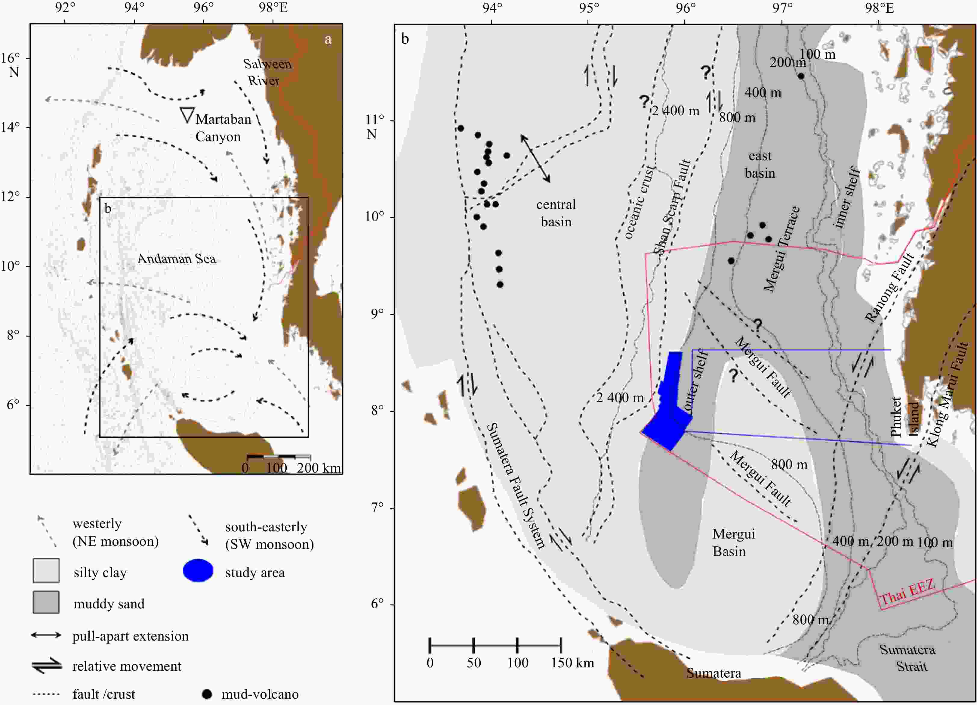
Figure 1. Synthetic maps showing location of the Andaman Sea in the Northeast Indian Ocean. Patterns of seasonal sea-surface circulation including the westerly currents (NE monsoon) and the south-easterly currents (SW monsoon) are summarily redrawn from Rodolfo (1969) (a). The tectonic setting of the Andaman Basin redrawn from Curry (2005). Sediment textures covering the basin are redrawn from Rodolfo (1969). The blue box shows the investigated area (b). EEC: exclusive economic zone.
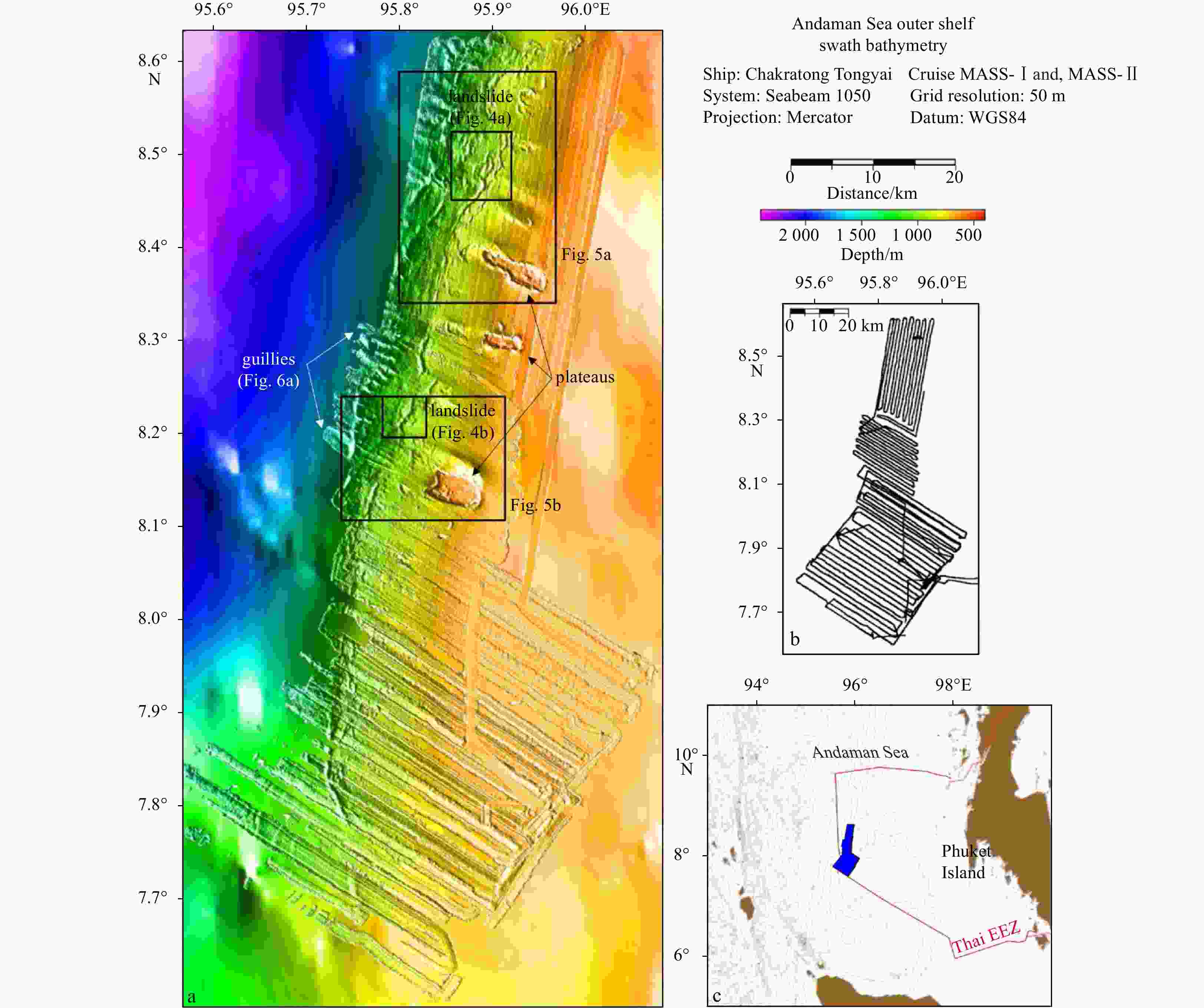
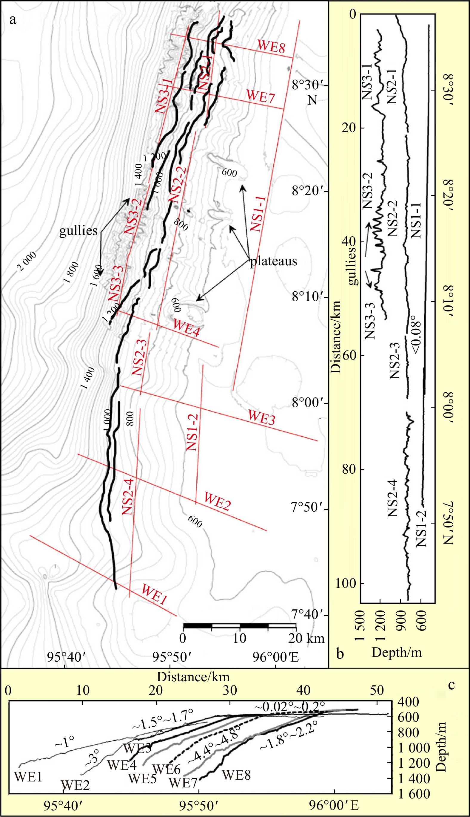
Figure 2. A new detailed bathymetry of the upper slope of the Andaman Sea outer shelf is overlain on GEBCO 30-arc second GDA (The GEBCO_08 Grid, 2010) (a) and complements them with ship track-lines (b) and location of the study area (c). The investigated area is shown by a blue box. Detailed information in submarine landslides are shown in Figs 4a and b, plateaus are shown in Figs 5a and b, and gullies are shown in Fig. 6a.
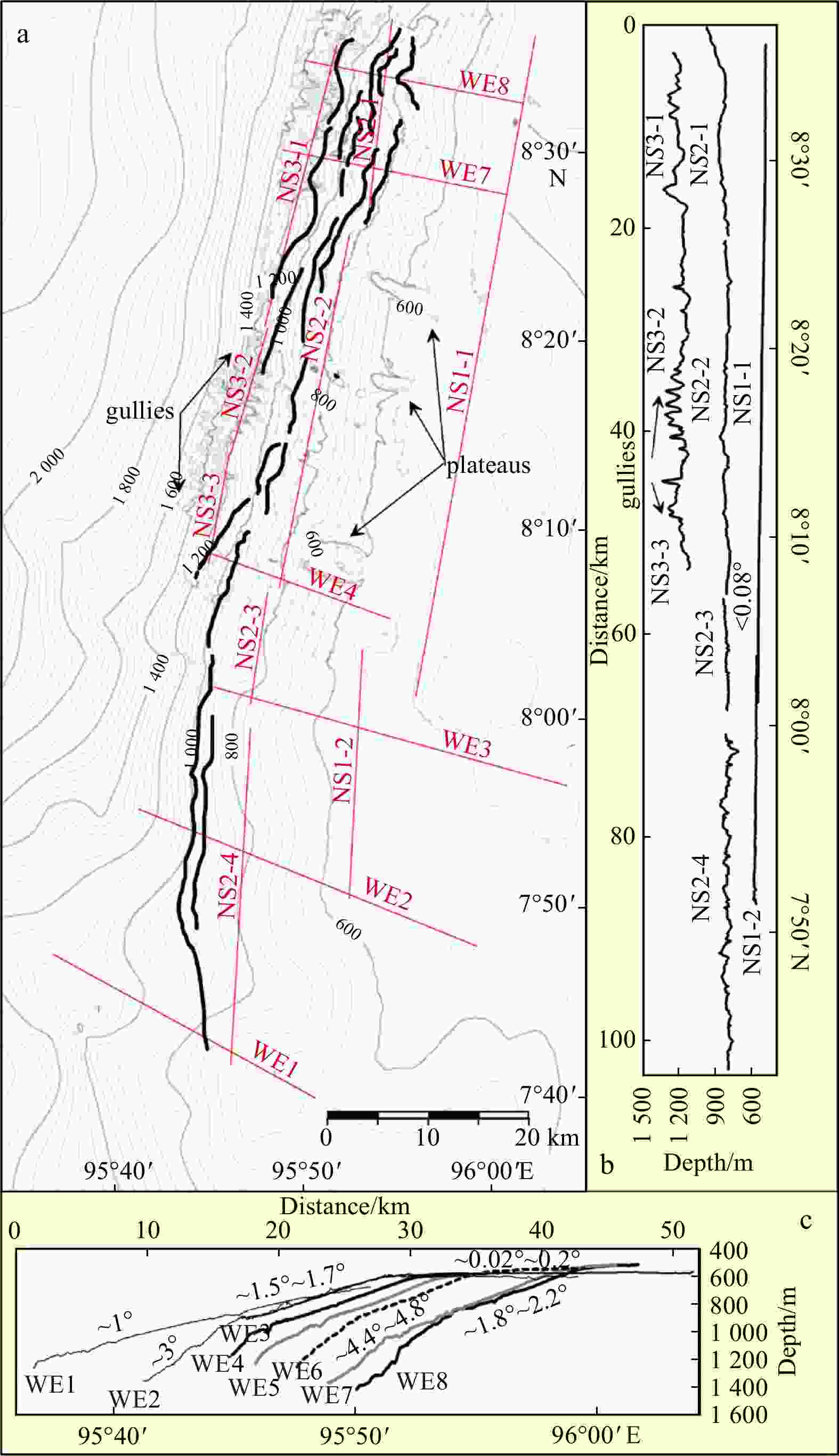
Figure 3. Interpretation of the bathymetry shows prominent features, including three large plateaus surrounded by moats (a) . Drawn lines of slope ruggedness are shown by black lines. Contour interval is 40 m. Latitudinal (NS1-1 to NS3-3) (b) and longitudinal profiles (c)(WE1 to WE8) show the general morphological trends of the Andaman Sea outer shelf and upper slope.
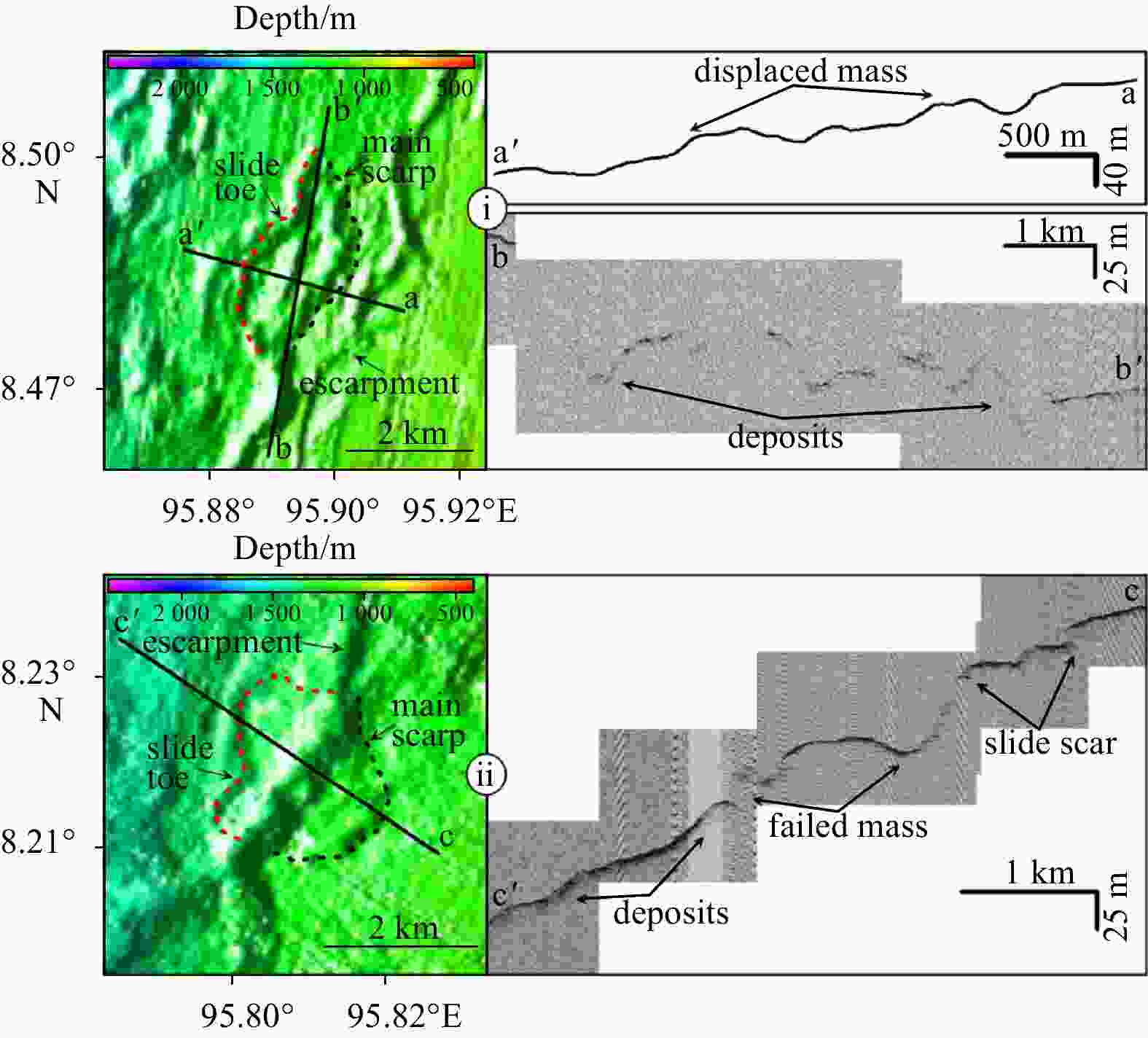
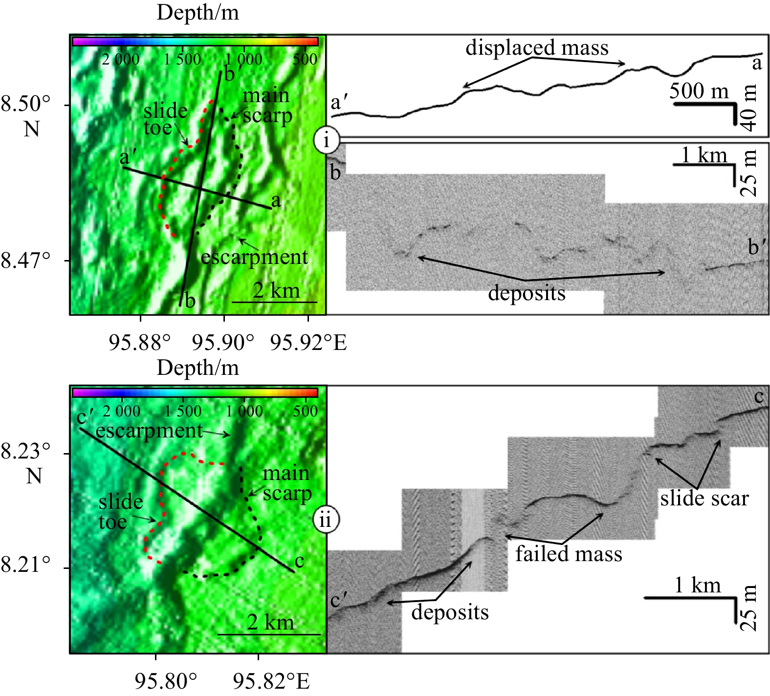
Figure 4. Color-coded shaded relief maps with interpretation showing possible submarine landslides on the northernmost (i) and the middle part (ii) of the Andaman outer shelf and upper slope. Black dotted-lines show approximated slide scars, while red dotted-lines show approximated slide toes. Profile aa′ and a subbottom profiler record along Profile cc′ show a slide scar and convex-upward slopes that could represent displaced mass and slide deposits. Echo-character along Profile bb′ presents possible sediment deposit. For locations of both slides refer to Fig. 2.
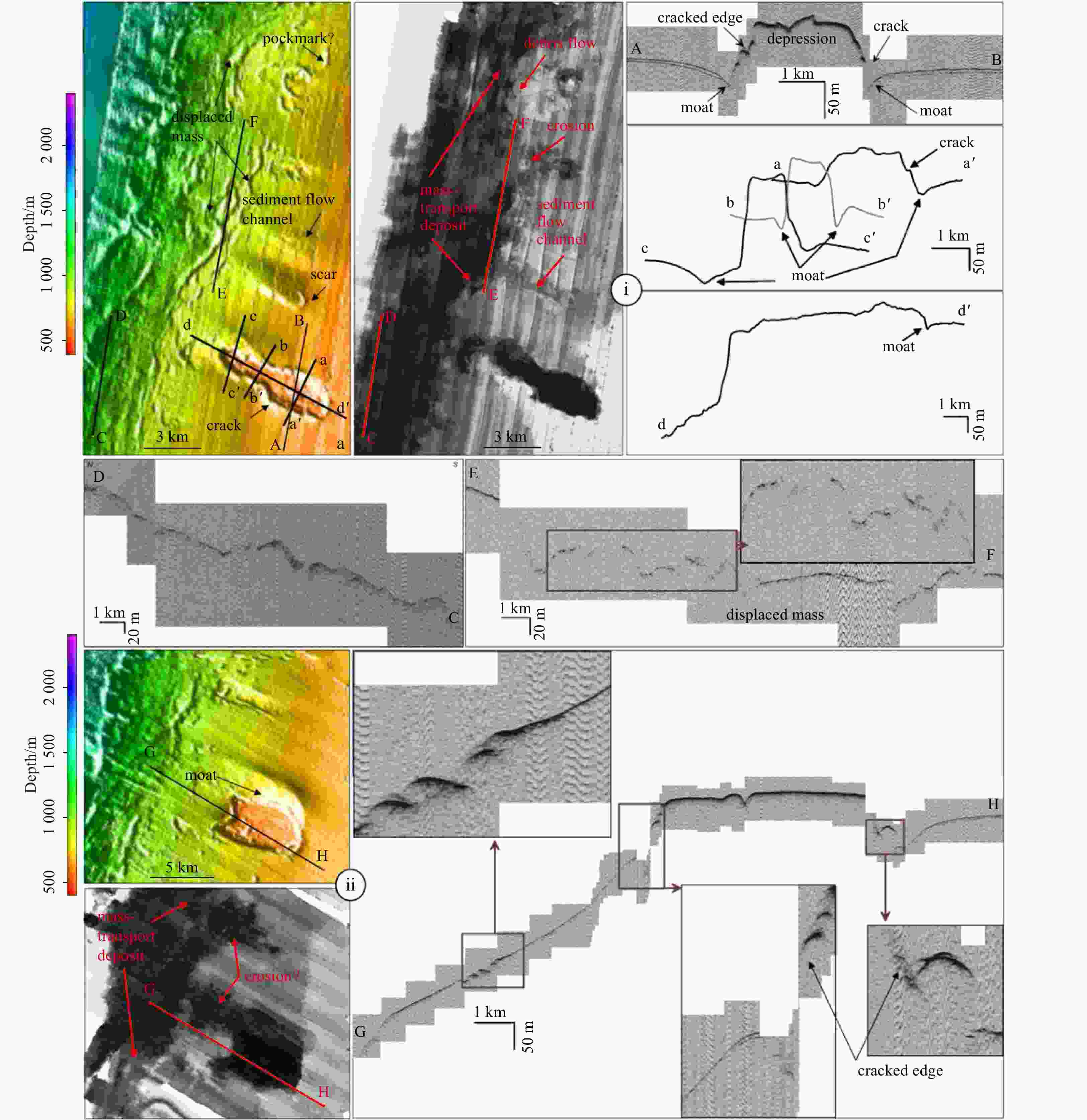
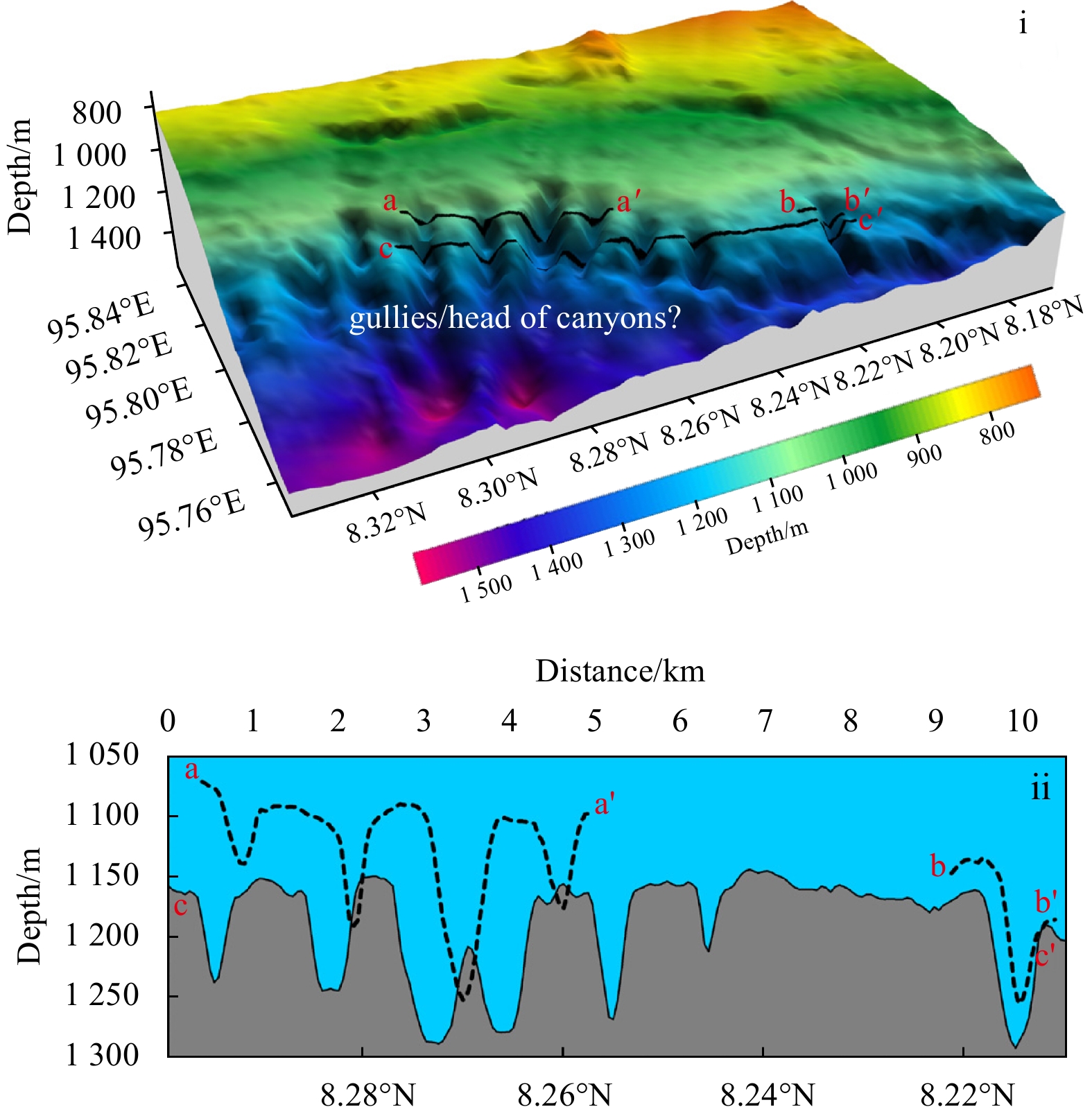
Figure 5. Morphology of the northern plateau (i) and the southern plateau (ii) are shown by bathymetry, backscattering imagery and their high frequency subbottom profiles. The boundaries of possible sediment failure deposits are marked by red dotted lines. Locations of plateaus refer to Fig. 2.
-
Bellec V K, Bøe R, Rise L, et al. 2010. Rippled scour depressions on continental shelf bank slopes off Nordland and Troms, Northern Norway. Continental Shelf Research, 30(9): 1056–1069. doi: 10.1016/j.csr.2010.02.006 Beyer A, Rathlau R, Schenke H W. 2005. Multibeam bathymetry of the Håkon Mosby mud volcano. Marine Geophysical Researches, 26(1): 61–75. doi: 10.1007/s11001-005-1131-8 Beyer A, Schenke H W, Klenke M, et al. 2003. High resolution bathymetry of the eastern slope of the Porcupine Seabight. Marine Geology, 198(1–2): 27–54. doi: 10.1016/S0025-3227(03)00093-8 Brune S, Babeyko A Y, Gaedicke C, et al. 2010a. Hazard assessment of underwater landslide-generated tsunamis: a case study in the Padang region, Indonesia. Natural Hazards, 53(2): 205–218. doi: 10.1007/s11069-009-9424-x Brune S, Babeyko A Y, Ladage S, et al. 2010b. Landslide tsunami hazard in the Indonesian Sunda Arc. Natural Hazards and Earth System Sciences, 10(3): 589–604. doi: 10.5194/nhess-10-589-2010 Brune S, Ladage S, Babeyko A Y, et al. 2010c. Submarine landslides at the eastern Sunda margin: observations and tsunami impact assessment. Natural Hazards, 54(2): 547–562. doi: 10.1007/s11069-009-9487-8 Bull S, Cartwright J, Huuse M. 2009. A review of kinematic indicators from mass-transport complexes using 3D seismic data. Marine and Petroleum Geology, 26(7): 1132–1151. doi: 10.1016/j.marpetgeo.2008.09.011 Caress D W, Chayes D N. 2004. MB-System Version 5, Open source software distributed.http://www.mbari.org/data/mbsystem/ [2003-12-05] Curray J R. 2005. Tectonics and history of the Andaman Sea region. Journal of Asian Earth Sciences, 25(1): 187–232. doi: 10.1016/j.jseaes.2004.09.001 Chough S K, Lee S H, Kim J W, et al. 1997. Chirp (2–7 kHz) echo characters in the Ulleung Basin. Geosciences Journal, 1(3): 143–153. doi: 10.1007/BF02910206 Damuth J E. 1975. Echo character of the western equatorial Atlantic floor and its relationship to the dispersal and distribution of terrigenous sediments. Marine Geology, 18(2): 17–45. doi: 10.1016/0025-3227(75)90047-X Damuth J E. 1978. Echo character of the Norwegian-Greenland Sea: relationship to Quaternary sedimentation. Marine Geology, 28(1–2): 1–36. doi: 10.1016/0025-3227(78)90094-4 Damuth J E. 1980. Use of high-frequency (3.5–12 kHz) echograms in the study of near-bottom sedimentation processes in the deep-sea: a review. Marine Geology, 38(1–3): 51–75. doi: 10.1016/0025-3227(80)90051-1 Damuth J E, Hayes D E. 1977. Echo character of the East Brazilian continental margin and its relationship to sedimentary processes. Marine Geology, 24(2): 73–95. doi: 10.1016/0025-3227(77)90002-0 de Alteriis G, Passaro S, Tonielli R. 2003. New, high resolution swath bathymetry of Gettysburg and Ormonde Seamounts (Gorringe Bank, eastern Atlantic) and first geological results. Marine Geophysical Researches, 24(3): 223–244. doi: 10.1007/s11001-004-5884-2 Domzig A, Gaullier V, Giresse P, et al. 2009. Deposition processes from echo-character mapping along the western Algerian margin (Oran-Tenes), Western Mediterranean. Marine and Petroleum Geology, 26(5): 673–694. doi: 10.1016/j.marpetgeo.2008.05.006 Hampton M A, Lee H J, Locat J. 1996. Submarine landslides. Reviews of Geophysics, 34(1): 33–59. doi: 10.1029/95RG03287 IOC, IHO, and BODC, 2003 , “Centenary Edition of the GEBCO Digital Atlas”, published on CD-ROM on behalf of the Intergovernmental Oceanographic Commission and the International Hydrographic Organization as part of the General Bathymetric Chart of the Oceans; British Oceanographic Data Centre, Liverpool. Jackson P D, Gunn D A, Long D. 2004. Predicting variability in the stability of slope sediments due to earthquake ground motion in the AFEN area of the western UK continental shelf. Marine Geology, 213(1–4): 363–378. doi: 10.1016/j.margeo.2004.10.014 Jenkins C J, Keene J B. 1992. Submarine slope failures of the southeast Australian continental slope: a thinly sedimented margin. Deep-Sea Research Part A: Oceanographic Research Papers, 39(2): 121–136. doi: 10.1016/0198-0149(92)90100-8 Khan P K, Chakraborty P P. 2005. Two-phase opening of Andaman Sea: a new seismotectonic insight. Earth and Planetary Science Letters, 229(3–4): 259–271. doi: 10.1016/j.jpgl.2004.11.010 Lee H, Baraza J. 1999. Geotechnical characteristics and slope stability in the Gulf of Cadiz. Marine Geology, 155(1–2): 173–190. doi: 10.1016/S0025-3227(98)00146-7 Lee H J, Syvitski J P M, Parker G, et al. 2002. Distinguishing sediment waves from slope failure deposits: field examples, including the ‘Humboldt slide’, and modelling results. Marine Geology, 192(1–3): 79–104. doi: 10.1016/S0025-3227(02)00550-9 Levchenko O V, Verzhbitskii V E, Lobkovskii L I. 2008. Submarine landslide structures in neopleistocene deposits on the western slope of the Derbent basin of the Caspian Sea. Oceanology, 48(6): 864–871. doi: 10.1134/S000143700806012X Leynaud D, Mienert J, Vanneste M. 2009. Submarine mass movements on glaciated and non-glaciated European continental margins: a review of triggering mechanisms and preconditions to failure. Marine and Petroleum Geology, 26(5): 618–632. doi: 10.1016/j.marpetgeo.2008.02.008 Locat J, Lee H, ten Brink U S, et al. 2009. Geomorphology, stability and mobility of the Currituck slide. Marine Geology, 264(1–2): 28–40. doi: 10.1016/j.margeo.2008.12.005 Loncke L, Droz L, Gaullier V, et al. 2009a. Slope instabilities from echo-character mapping along the French Guiana transform margin and Demerara abyssal plain. Marine and Petroleum Geology, 26(5): 711–723. doi: 10.1016/j.marpetgeo.2008.02.010 Loncke L, Gaullier V, Droz L, et al. 2009b. Multi-scale slope instabilities along the Nile deep-sea fan, Egyptian margin: a general overview. Marine and Petroleum Geology, 26(5): 633–646. doi: 10.1016/j.marpetgeo.2008.03.010 Masson D G, Watts A B, Gee M J R, et al. 2002. Slope failures on the flanks of the western Canary Islands. Earth-Science Reviews, 57(1–2): 1–35. doi: 10.1016/S0012-8252(01)00069-1 McAdoo B G, Watts P. 2004. Tsunami hazard from submarine landslides on the Oregon continental slope. Marine Geology, 203(3–4): 235–245. doi: 10.1016/S0025-3227(03)00307-4 Moscardelli L, Wood L, Mann P. 2006. Mass-transport complexes and associated processes in the offshore area of Trinidad and Venezuela. AAPG Bulletin, 90(7): 1059–1088. doi: 10.1306/02210605052 Mosher D C, Austin Jr J A, Fisher D, et al. 2008. Deformation of the northern Sumatra accretionary prism from high-resolution seismic reflection profiles and ROV observations. Marine Geology, 252(3–4): 89–99. doi: 10.1016/j.margeo.2008.03.014 Mulder T, Cochonat P. 1996. Classification of offshore mass movements. Journal of Sedimentary Research, 66(1): 43–57. doi: 10.1306/D42682AC-2B26-11D7-8648000102C1865D Pan Xiaoyi, Li Linlin, Nguyễn P H, et al. 2022. Submarine landslides in the west continental slope of the South China Sea and their tsunamigenic potential. Frontiers in Earth Science, 10: 843173. doi: 10.3389/feart.2022.843173 Polachan S, Racey A. 1993. Lower Miocene larger foraminifera and petroleum potential of the Tai Formation, Mergui Group, Andaman Sea. Journal of Southeast Asian Earth Sciences, 8(1–4): 487–496. doi: 10.1016/0743-9547(93)90047-S Pratson L F, Laine E P. 1989. The relative importance of gravity-induced versus current-controlled sedimentation during the Quaternary along the Mideast U. S. outer continental margin revealed by 3.5 kHz echo character. Marine Geology, 89(1–2): 87–126. doi: 10.1016/0025-3227(89)90029-7 Raju K A K, Ramprasad T, Rao P S, et al. 2004. New insights into the tectonic evolution of the Andaman Basin, Northeast Indian Ocean. Earth and Planetary Science Letters, 221(1–4): 145–162. doi: 10.1016/S0012-821X(04)00075-5 Ramaswamy V, Rao P S, Rao K H, et al. 2004. Tidal influence on suspended sediment distribution and dispersal in the northern Andaman Sea and Gulf of Martaban. Marine Geology, 208(1): 33–42. doi: 10.1016/j.margeo.2004.04.019 Rao P S, Ramaswamy V, Thwin S. 2005. Sediment texture, distribution and transport on the Ayeyarwady continental shelf, Andaman Sea. Marine Geology, 216(4): 239–247. doi: 10.1016/j.margeo.2005.02.016 Reddy D R, Rao T S. 1997. Echo characters of the continental margin, western Bay of Bengal, India. Marine Geology, 140(1–2): 201–217. doi: 10.1016/S0025-3227(97)00016-9 Rodolfo K S. 1969. Sediments of the Andaman Basin, northeastern Indian Ocean. Marine Geology, 7(5): 371–402. doi: 10.1016/0025-3227(69)90014-0 Saidova K M. 2008. Benthic foraminifera communities of the Andaman Sea (Indian Ocean). Oceanology, 48(4): 517–523. doi: 10.1134/S0001437008040073 Seeber L, Mueller C, Fujiwara T, et al. 2007. Accretion, mass wasting, and partitioned strain over the 26 Dec 2004 Mw 9.2 rupture offshore Aceh, northern Sumatra. Earth and Planetary Science Letters, 263(1–2): 16–31. doi: 10.1016/j.jpgl.2007.07.057 Silva A J, Baxter C D P, LaRosa P T, et al. 2004. Investigation of mass wasting on the continental slope and rise. Marine Geology, 203(3–4): 355–366. doi: 10.1016/S0025-3227(03)00315-3 Sultan N, Cochonat P, Canals M, et al. 2004. Triggering mechanisms of slope instability processes and sediment failures on continental margins: a geotechnical approach. Marine Geology, 213(1–4): 291–321. doi: 10.1016/j.margeo.2004.10.011 Sultan N, Voisset M, Marsset B, et al. 2007. Potential role of compressional structures in generating submarine slope failures in the Niger Delta. Marine Geology, 237(3–4): 169–190. doi: 10.1016/j.margeo.2006.11.002 Sun Qiliang, Cartwright J, Xie Xinong, et al. 2018. Reconstruction of repeated Quaternary slope failures in the northern South China Sea. Marine Geology, 401: 17–35. doi: 10.1016/j.margeo.2018.04.009 Sun Qiliang, Leslie S. 2020. Tsunamigenic potential of an incipient submarine slope failure in the northern South China Sea. Marine and Petroleum Geology, 112: 104111. doi: 10.1016/j.marpetgeo.2019.104111 Synolakis C E, Bardet J P, Borrero J C, et al. 2002. The slump origin of the 1998 Papua New Guinea Tsunami. Proceedings of the Royal Society A: Mathematical, Physical and Engineering Sciences, 458(2020): 763–789, Terry J P, Winspear N, Goff J, et al. 2017. Past and potential tsunami sources in the South China Sea: a brief synthesis. Earth-Science Reviews, 167: 47–61. doi: 10.1016/j.earscirev.2017.02.007 The GEBCO_08 Grid. 2010. version 20100927. http://www.gebco.net[2010-10-25] Tingay M R P, Morley C K, Hillis R R, et al. 2010. Present-day stress orientation in Thailand’s basins. Journal of Structural Geology, 32(2): 235–248. doi: 10.1016/j.jsg.2009.11.008 Vanneste M, Mienert J, Bünz S. 2006. The Hinlopen Slide: a giant, submarine slope failure on the northern Svalbard margin, Arctic Ocean. Earth and Planetary Science Letters, 245(1–2): 373–388. doi: 10.1016/j.jpgl.2006.02.045 von Huene R, Ranero C R, Watts P. 2004. Tsunamigenic slope failure along the Middle America Trench in two tectonic settings. Marine Geology, 203(3–4): 303–317. doi: 10.1016/S0025-3227(03)00312-8 Watts P, Grilli S T, Kirby J T, et al. 2003. Landslide tsunami case studies using a Boussinesq model and a fully nonlinear tsunami generation model. Natural Hazards and Earth System Sciences, 3(5): 391–402. doi: 10.5194/nhess-3-391-2003 Wessel P, Smith W H F. 1998. New, improved version of generic mapping tools released. Eos, Transactions American Geophysical Union, 79(47): 579, -

 下载:
下载:


 点击查看大图

计量
- 文章访问数: 395
- HTML全文浏览量: 191
- PDF下载量: 41
- 被引次数: 0

