ÖZGAN Sinan, ALP Hakan, BAYAT Oğuz, VARDAR Denizhan. Acoustical imaging of the nearshore seafloor depositions and deformations, a key study for Western Istanbul, Türkiye[J]. Acta Oceanologica Sinica. doi: 10.1007/s13131-023-2197-3
Citation:
ÖZGAN Sinan, ALP Hakan, BAYAT Oğuz, VARDAR Denizhan. Acoustical imaging of the nearshore seafloor depositions and deformations, a key study for Western Istanbul, Türkiye[J]. Acta Oceanologica Sinica. doi: 10.1007/s13131-023-2197-3
ÖZGAN Sinan, ALP Hakan, BAYAT Oğuz, VARDAR Denizhan. Acoustical imaging of the nearshore seafloor depositions and deformations, a key study for Western Istanbul, Türkiye[J]. Acta Oceanologica Sinica. doi: 10.1007/s13131-023-2197-3
Citation:
ÖZGAN Sinan, ALP Hakan, BAYAT Oğuz, VARDAR Denizhan. Acoustical imaging of the nearshore seafloor depositions and deformations, a key study for Western Istanbul, Türkiye[J]. Acta Oceanologica Sinica. doi: 10.1007/s13131-023-2197-3
To protect the sustainability of the benefits from seas and near coastal areas, which have under the effect of the very complex hydrodynamic conditions and intensive human activities, without disrupting the balance of nature, it is necessary to image the status of the seafloor features. Therefore, this study presents the deformations, depositional conditions, underwater constructions, and the other non-natural impacts on the seafloor of the nearshore area at western Istanbul (between Küçükçekmece and Büyükçekmece Lagoons) where it intensely used by the citizens. The results of the study may provide some guidance for understanding the impacts and risk factors of uses that are or will be conducted in coastal and/or near-coastal areas. Construction planning for civil coastal structures and areas should be done in great harmony with nature, minimizing negative environmental impacts. Although sediment distribution in the area is generally quite complex, the current state of the region, wave action, hydrodynamic conditions, the amount of material transported from the land, and bathymetry are important influencing factors. The seafloor has been damaged primarily by anchor deformation and associated bottom scanning, as well as disturbing trawl tracks. The seafloor was observed as partially shallowing near the constructions (such as natural gas pipelines, fishermen's shelter, and port piles) of coastal areas and associated with sand deposits. Therefore, scanning the seafloor using side-scan sonar may provide valuable frequency data to prevent future disruptions.
Figure 1. Location (a), bathymetry (b), regional geology maps of the study area (c) (Alp et al., 2018).
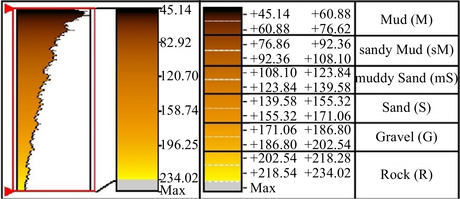
Figure 2. Acoustic returns of the seafloor formations.
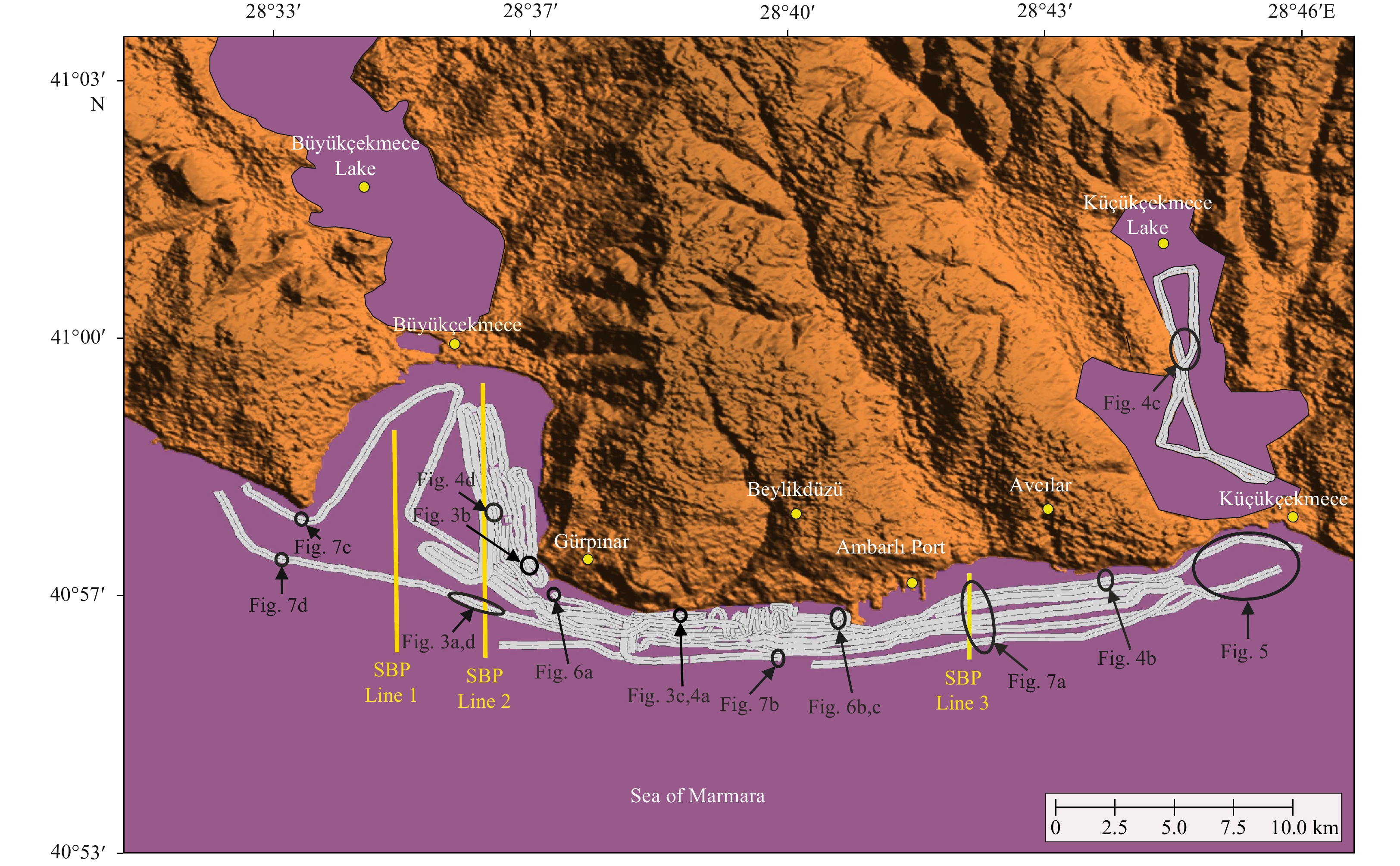
Figure 3. The location map of the acoustic data (SSS, and SBP), and the mosaic map.
Figure 4. SSS ecograms showing the difference acoustic reflections.
Figure 5. Morphological structures formed on the seafloor.
Figure 6. Deformations caused by fishing and the boats on the seafloor (anchor and trawl web tracks).
Figure 7. Port and supply line feet view.
Figure 8. Pipelines, wreck, and rubble flow image.
Figure 9. Seafloor natural structures and formation types by seismic method (SBP Line 1) (a), Paleo Shoreline, gas, and formation types (SBP Line 2) (b), Formation types, rock exposure and pipeline view (SBP Line 3) (c).
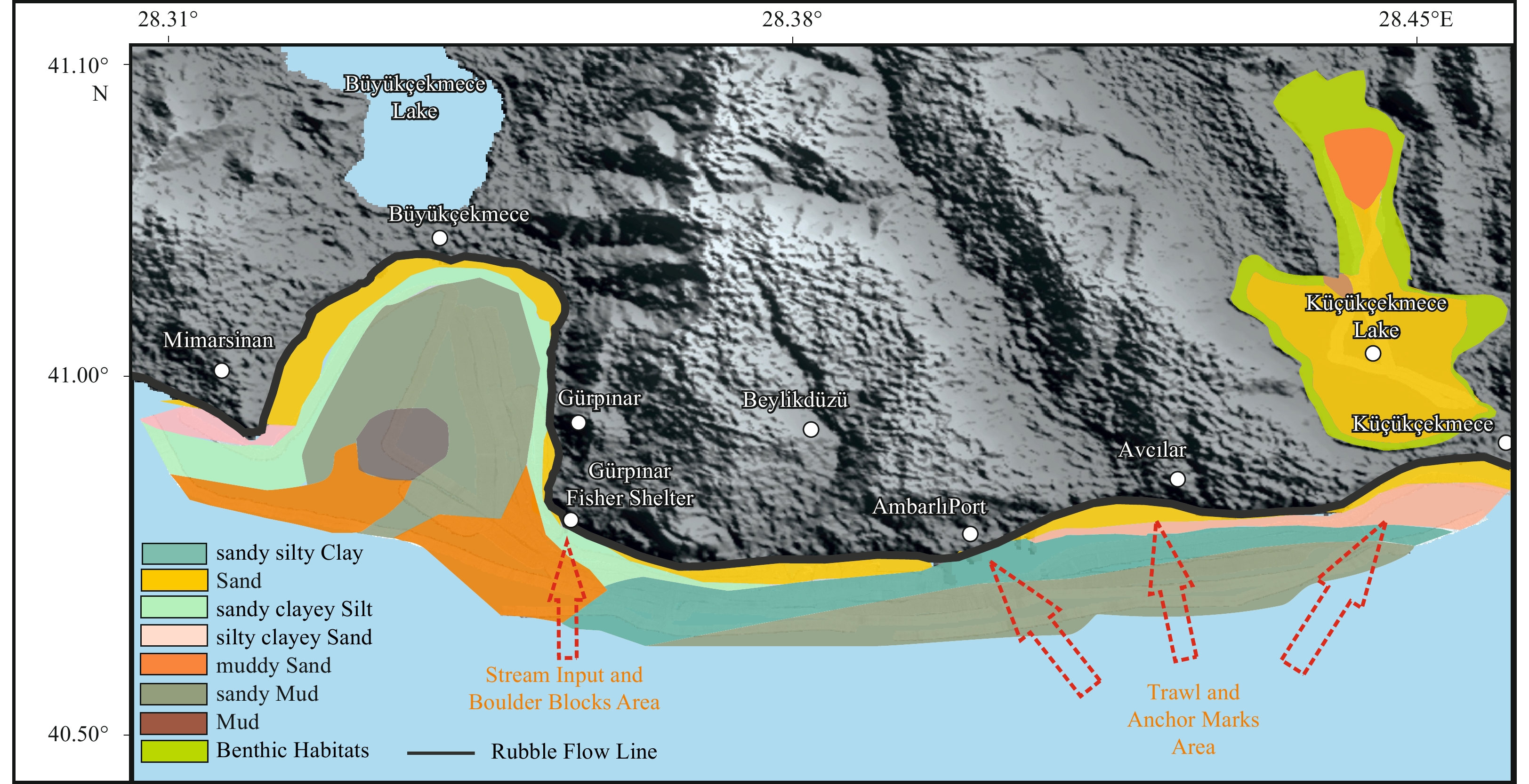
Figure 10. Seafloor sediment distributions and deformation map.


 DownLoad: