Xiaoyu Liu, Yilan Chen, Chenguang Liu, Qiuhua Tang, Yanhong Wang, Shan Gao. Detailed seafloor geomorphology of the western region of the North Yellow Sea, China: The result of Holocene erosional and depositional processes sculpting the offshore continental shelf[J]. Acta Oceanologica Sinica, 2022, 41(12): 38-47. doi: 10.1007/s13131-022-2060-y
Citation:
Xiaoyu Liu, Yilan Chen, Chenguang Liu, Qiuhua Tang, Yanhong Wang, Shan Gao. Detailed seafloor geomorphology of the western region of the North Yellow Sea, China: The result of Holocene erosional and depositional processes sculpting the offshore continental shelf[J]. Acta Oceanologica Sinica, 2022, 41(12): 38-47. doi: 10.1007/s13131-022-2060-y
Xiaoyu Liu, Yilan Chen, Chenguang Liu, Qiuhua Tang, Yanhong Wang, Shan Gao. Detailed seafloor geomorphology of the western region of the North Yellow Sea, China: The result of Holocene erosional and depositional processes sculpting the offshore continental shelf[J]. Acta Oceanologica Sinica, 2022, 41(12): 38-47. doi: 10.1007/s13131-022-2060-y
Citation:
Xiaoyu Liu, Yilan Chen, Chenguang Liu, Qiuhua Tang, Yanhong Wang, Shan Gao. Detailed seafloor geomorphology of the western region of the North Yellow Sea, China: The result of Holocene erosional and depositional processes sculpting the offshore continental shelf[J]. Acta Oceanologica Sinica, 2022, 41(12): 38-47. doi: 10.1007/s13131-022-2060-y
Detailed seafloor geomorphology of the western region of the North Yellow Sea, China: The result of Holocene erosional and depositional processes sculpting the offshore continental shelf
First Institute of Oceanography, Ministry of Natural Resources, Qingdao 266100, China
2.
Key Laboratory of Oceanic Surveying and Mapping, Ministry of Natural Resources, Qingdao 266590, China
Funds:
The National Natural Science Foundation of China under contract Nos 41506069 and 41876111; the Open Fund of Key Laboratory of Marine Surveying and Mapping of the Ministry of Natural Resources under contract No. 2021B01.
High-resolution multi-beam/single-beam bathymetric data and seismic profiling data from the latest surveys are used to map and interpret the detailed seafloor geomorphology of the western region of the North Yellow Sea (NYS), China. The mapping area covers 156 410 km2, and incorporates a flat shelf plain, subaqueous accumulation shoals, tidal scouring troughs, and tidal sand ridge groups. Offshore areas with water depths less than 50 m in the western region of the NYS are mainly covered by thick, loose sediments, forming wide spread accumulation geomorphological features; these include the Liaodong Peninsula subaqueous accumulation system containing shoals and rugged scouring troughs, and the large mud wedge of the Shandong Peninsula. In the central part of the NYS, there is a relatively flat residual shelf plain with coarser sediment deposits. This flat shelf plain has a water depth larger than 50 m and a thin layer of sediment, on which there is a large pockmark field caused by seafloor seepage. These geomorphological structures indicate that modern sedimentary processes are the main driving force controlling the sculpture of the current seafloor surface landform. Extensive strong tidal current systems and abundant sediment sources provide the critical external forces and essential conditions for the formation of seafloor geomorphology. The tectonic basement controls the macroscopic morphological shape of the NYS, but is reflected very little in the seafloor geomorphic elements. Our results provide a detailed seafloor geomorphological map of the western region of the NYS, an area that has not previously mapped and also provide a scientific framework for further research into offshore seafloor geomorphology, shelf sedimentary processes, and submarine engineering construction in this region.
The offshore continental shelf is a natural prolongation of the land into the sea, and is also a key area where terrigenous loose sediments discharge into the sea. Complex hydrodynamic systems, including rivers, tidal waves, and currents drive the migration and deposition of sediments (Milliman and Syvitski, 1992; Gensac et al., 2016). Meanwhile, strong hydrodynamic forces erode and locally cut the seafloor, shaping various erosional and depositional landforms. Offshore seafloor geomorphology and its evolution is fundamental to gain a comprehensive understanding of offshore geological processes, such as dynamic sedimentation, history of tectonic activity, global climate change, and sea-level fluctuation (Liu et al., 2005; Nichol et al., 2011).
The North Yellow Sea (NYS) is a semi-enclosed shallow sea on the continental shelf of eastern China, with a water depth of <70 m. Several rivers carry high volumes of terrigenous sediment into the NYS, forming various geomorphological features; the subaqueous delta of the Yalu River Estuary, large-scale tidal sand ridges of the Korean Bay, and large mud wedges have received particular attention (Liu et al., 2004; Yang and Liu, 2007). In addition, there are numerous islands and erosional landforms, such as deep scour troughs, in the Laotieshan Channel. Through surveys conducted in offshore areas of China between the 1950s and 1980s, large quantities of bathymetric and sonar data were obtained from the NYS, which contributed to a relatively comprehensive understanding of the geomorphology of the NYS seafloor (Lin, 1989; Geng, 1981). Owing to the low resolution of the survey equipment at that time, fine details of the seafloor were unable to be displayed, thus limiting the accuracy of research on seafloor geomorphology. In recent years, oceanographic surveys have adopted high-resolution multi-beam bathymetric systems and various pieces of high-resolution sonar and seismic exploration equipment, which have facilitated the discovery and study of the detailed geomorphology of offshore China (Liu et al., 2005; Cai et al., 2013). A series of new discoveries and an increased understanding of the geological environment have been made in the NYS, including its stratigraphic structure (Liu et al., 2005; Chen et al., 2011; Chen, 2014), surface sedimentary environment (Cheng and Gao., 2000; Qi et al., 2004; Wang et al., 2009; Qiao et al., 2017), and seafloor pockmark field (Chen et al., 2017; Wang et al., 2018; Liu et al., 2019). These findings have provided new evidence to better understand dynamic geomorphological processes in offshore areas. However, the details of distinctive geomorphological features in the western NYS, such as submarine shoals and scour trough system, have yet to be reported, and the classification of these features according to widely accepted geomorphological standard is still lacking, as is, a detailed full-coverage geomorphological map of the NYS employing high resolution multibeam bathymetry.
In this paper, we use newly acquired high-resolution multi-beam sonar data to characterize the fine-scale (25 m spatial resolution) geomorphology of the western region of the NYS; three typical seafloor geomorphological units found in this region are discussed in turn, and several new micro-geomorphological features are revealed and described in detail. In addition, the geomorphology of the seafloor of the NYS is mapped in full using this bathymetric mode, coupled with side-scan sonar, sub-bottom profiling, sediment data, and relevant research results from the past two decades. The origin and evolution of the seafloor geomorphology is also discussed and explored in terms of geological structure, nearshore current systems, and modern sedimentation processes. Results from this study will help improve our understanding of the geomorphology of offshore continental shelves and provide insights into offshore seabed formation processes.
2.
Geographical background of the NYS
The seafloor topography of the NYS tilts from the north, west, and southwest to the central region. The western region of the NYS is connected to the Bohai Sea through the Bohai Strait, and the central region dips southwards into the South Yellow Sea. Tectonically, the NYS is a fault-bounded basin developed on the Jiaoliao Uplift. Fault structures are developed on both the margins and within the basin, and the main tectonic structures trend NE−SW. The basement of the basin comprises of Sinian crystalline rocks, overlain by Sinian, Upper Mesozoic, and Quaternary strata. Since the Cenozoic, most of the structural forms in the basin have been covered by loose Quaternary sediments, except for the islands and reefs distributed in tectonically uplifted areas off the three peninsulas (Liaodong Peninsula, Korean Peninsula, and Shandong Peninsula) and in the Bohai Strait (Li et al., 2009, 2006; Shen et al., 2013). There have been three sedimentary transgression-regression-transgression cycles in the NYS since the late Quaternary, sedimentary strata are deposited in six stages (MIS6–MIS1), which correspond to different sedimentary environments formed during these cycles between the late Pleistocene and the Holocene (Liu et al., 2005; Chen et al., 2013).
During the Holocene, the NYS has received an abundant supply of terrigenous material which has resulted in a high sediment accumulation rate (Alexander, 1991). Rivers discharging into the NYS are mainly from the Liaodong Peninsula, and include the Yalu River (YLR), Dayang River (DYR), Zhuanghe River (ZHR), Biliu River (BLR), and Dengsha River (DSR) (Fig. 1). Moreover, several rivers enter the Yellow Sea from the Korean Peninsula, including the Datong River (DTR) and Hanjiang River (HJR). Only a short length of rivers flow into the Yellow Sea from the Shandong Peninsula, and most of these flow into the southern Yellow Sea, which has little impact on the NYS. The flow field of the NYS primarily comprises the Yellow Sea Warm Current, Yellow Sea Coastal Current, and Yellow Sea Circulation (Zhang et al., 2008; Liu et al., 2004). The NYS provides a channel through which the Yellow Sea Warm Current enters the Bohai Sea. The tidal current is of the semidiurnal type that rotates counterclockwise (Fig. 1). The complex hydrodynamic conditions and diverse material sources in this region exert considerable control on sediment resuspension, transportation, and deposition (Chough et al., 2000). Modern sediments with uneven thicknesses are deposited on the seafloor surface of the NYS. These sediments mainly comprise muddy silt, silt, sandy silt, silty sand, and sand. Gravels are present in local areas, while sand, silty sand, and sandy silt show widespread distributions; silt and mud occur only in relatively small areas (Lee and Chough, 1989; Qiao et al., 2017). The grain size of surface sediments gradually becomes coarser from southwest to northeast. Mud and silt predominate in the southeast corner of the study area, off the northern Shandong Peninsula. Sandy silt is predominantly deposited in the central region, with a gradual shift to silty sand toward the east, and finally sand in the easternmost region (Wang et al., 2009; Li et al., 2014).
Figure
1.
Rivers flowing into the Yellow Sea together with the seawater circulation model (Yang and Liu, 2007; Su and Yuan, 2005; Qiao et al., 2017) (a); mean grain size ($\varPhi $) of seafloor surface sediments in the North Yellow Sea (modified after Wang et al. (2009); Li et al. (2014)) (b). YSWC: Yellow Sea Warm Current; YSCC: Yellow Sea Coastal Current; NYSC: North Yellow Sea Circulation; LCC: Liaonan Coastal Current; BCC: Bohai Coastal Current; YLR: Yalu River; DYR: Dayang River; ZHR: Zhuanghe River; BLR: Biliu River; DSR: Dengsha River; DTR: Datong River; HJR: Hanjiang River; JJR: Jinjiang River; LHR: Luanhe River; HR: Haihe River; HHR: Huanghe River; WHR: Waste Huanghe River; CHJR: Changjiang River.
The data used in this study were mainly derived from seafloor topographic data acquired during five different surveys from 2008 to 2013. The multibeam echosounder systems used in the surveys include EM1002S, EM3000D, EM3002D (Kongsberg, Norway), Seabeam1180 (Elac, Germany) and Geoswath (GeoAcoustics, UK). These systems were calibrated before each voyage, and different systems were compared to eliminate systematic errors. All singlebeam data used in this study were collected using a HY1600 single beam echosounder. Data from published chart are also used where survey data were not available. The sea area covered by multi-beam data was 22 288 km2, accounting for ~46% of the study area, while the sea area covered by single-beam data accounted for 74% of the study area. The remaining data included chart data and global sea area topographic data. After further processing and accuracy assessment of all data, a digital seafloor bathymetry model with a spatial resolution of 25 m (multi-beam data areas) or 500 m (other data areas) was constructed. Seismic profiles used in this paper were collected using a SIG 16 single channel seismic hydrophones streamer, while a GEO-SPARK1000 sparker as source with the shooting energy of 300 J acted as the source. Graphs in this paper were constructed using Global Mapper 13, Surfer 16, and ArcGIS 10.0.
4.
Seafloor topographical and geomorphological features in the western region of the NYS
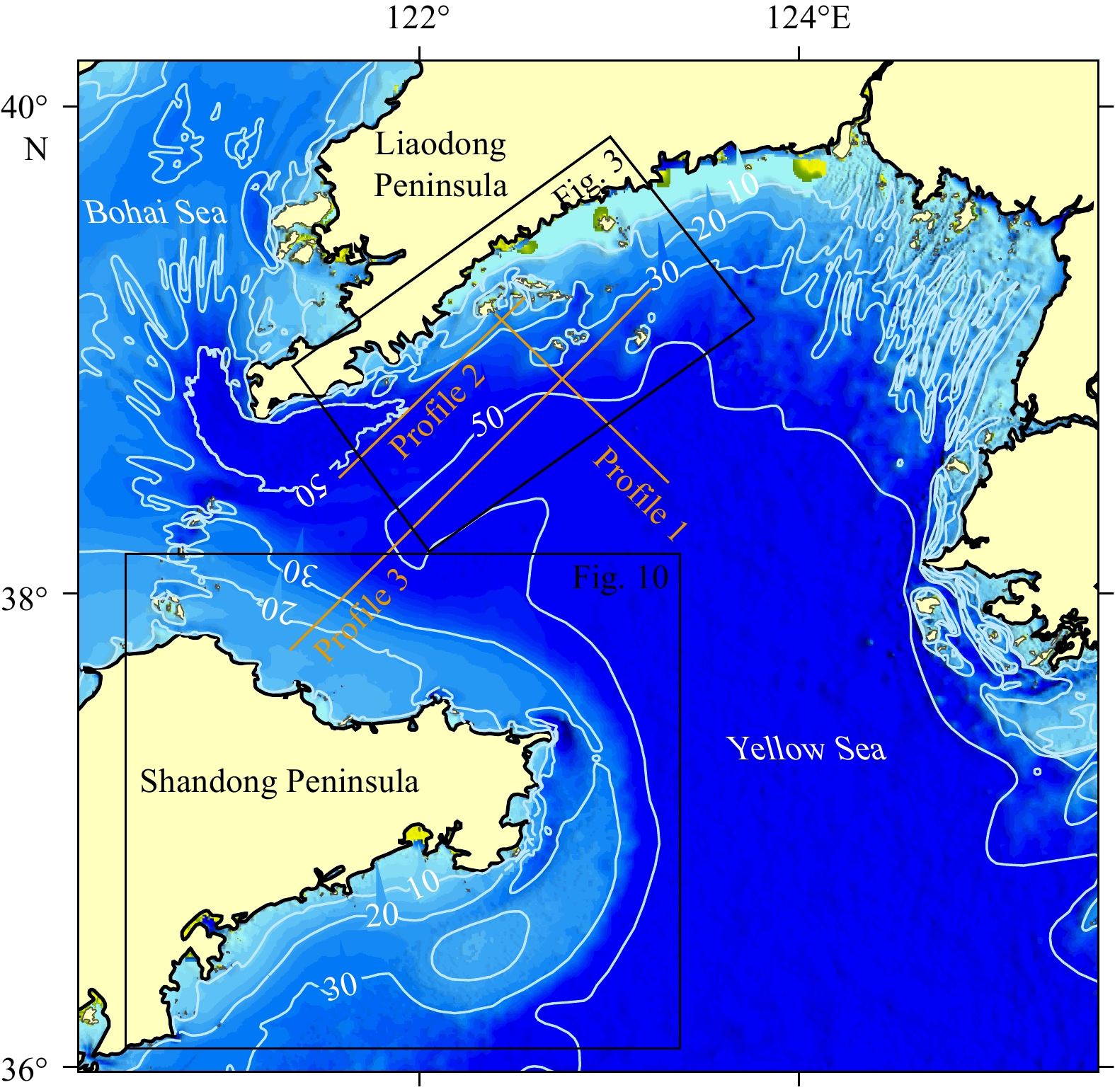
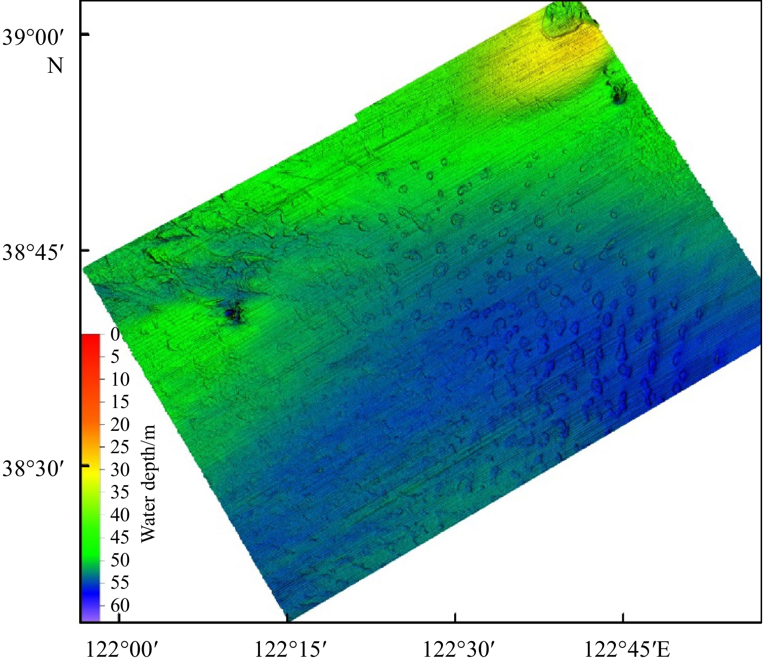
The water depth of the study area ranges from 0 m to 65 m, and becomes deeper from the nearshore to the basin center. In nearshore areas with water depths of <50 m, the bathymetric contours are parallel to the shoreline, except for islands; there is large topographic relief and changes in slope gradient (Fig. 2). In the central region of the study area, the topography is subdued and the water is relatively deep; the 50 m contour almost outlines the margin of the central basin. From north to south, the seafloor can be roughly divided into three typical geomorphological units: a dynamic tidal area off the southern Liaodong Peninsula; an erosion‒accumulative plain area in the central NYS; and an accumulation area off the northern Shandong Peninsula (Fig. 3).
Figure
2.
Seafloor topography of the North Yellow Sea. The lines in this figure are water bathymetric contours, and the marked numbers are the corresponding water depth values.
Figure
3.
Dynamic tidal geomorphological unit off the south coast of the Liaodong Peninsula. This image shows tongue- and mound-shaped subaqueous shoals developed to the southwest of the islands and scouring troughs surrounding the islands. The trend of the subaqueous shoals is consistent with the main current direction.
4.1
Dynamic tidal geomorphological unit off the Liaodong Peninsula
On the seafloor to the south of the Liaodong Peninsula, there is a geomorphological unit composed of islands and their surrounding underwater shoals and scour troughs. This islands‒tidal scour trough‒shoal group developed in nearshore waters (depth <50 m) and is a typical dynamic tidal geomorphological unit formed by the interaction of strong tidal currents and an archipelago (Xiao and Miao, 1995; Miao et al., 1995). The seafloor here around the islands is complex, has large topographic relief, and curved and variable bathymetric contours. Submerged reefs, water channels, erosional depressions, and inter-island deep troughs are common. The depth of water and gradient of slope on the south side of the islands is generally greater than on the north side. Tongue- and mound-shaped subaqueous shoals are developed to the west and southwest of the islands. The shoal surface is smooth with a bottom water depth of 40 m.
4.1.1
Tidal scour troughs
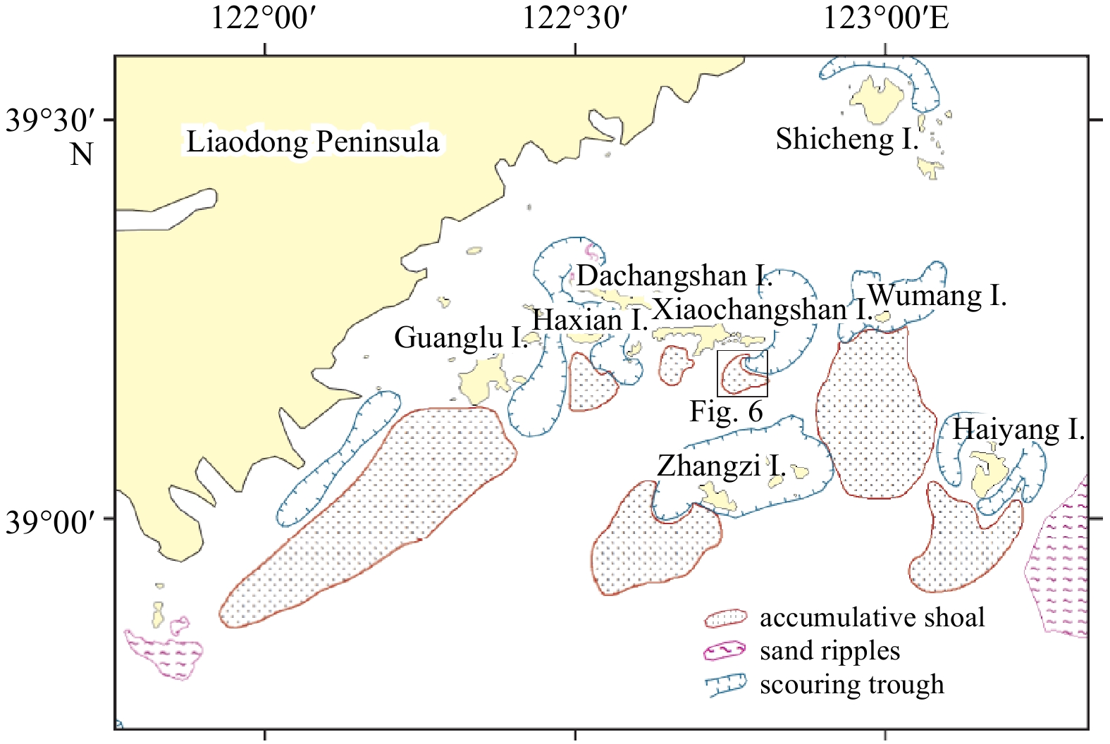
Narrow scour troughs, with widths of 2–6 km and depths of 5–10 m, are found between or around Guanglu Island, Changshan Archipelago, Haiyang Island, and Wumang Island (Fig. 4). There are obvious scouring traces at the bottom of these scour troughs, which are formed by a strong tidal current cutting into the seafloor around the islands. The deepest scour trough is 48 m, located to the northwest of Haiyang Island and northeast of Dalian Island. Sediments at the bottom of these scour troughs are very rough, composed of coarse-grained gravel, gravel-containing sand, medium-grained sand, and outcropping bedrock (Miao et al., 1995).
Figure
4.
Geomorphological sketch of the seafloor to the south of the Liaodong Peninsula. This image shows the distribution of accumulative shoal, sand ripples and scouring troughs in plan-view.
4.1.2
Subaqueous accumulative shoals and sand ripples
Subaqueous accumulative shoals, having tongue or mound shapes in plan-view, are developed to the southwest of each island of the Haiyang Island, and Wumang Island, and Changshan Archipelago. The largest accumulative shoal is located to the southwest of Guanglu Island; this has a long tongue-like shape, is 5.5 km in length and has a maximum width of 1.4 km. The width of this accumulation gradually decreases and pinches out to the southwest, and its long axis is NE–SW trending, which is consistent with the direction of the coastal current. There are also sporadic bedrock outcrops in the tail of the shoals (Figs 3 and 4). On seismic profiles, these accumulations show a nearly transparent reflection with oblique bedding, and their maximum thickness is 15 m (Fig. 5). According to the analysis of core samples, the sediments comprising these subaqueous accumulations were formed during a period of high sea level in the Holocene, and the underlying strata represent post glacial transgressive systems tract (Liu et al., 2004; Chen et al., 2013).
Figure
5.
Seismic profile 1. This profile is NW–SE trending. The left side of this profile comprises two subaqueous clinoforms in close proximity, the Guanglu Island shoal and the Haiyang Island shoal, which have been connected as a whole. The right side of this profile extends towards the SE and reaches the shelf plain in the central region of the North Yellow Sea.
There are subaqueous sand ripples on the top of the accumulative shoal located southeast of Xiaochangshan Island. The sand ripple area is approximately 6 km long from north to south and 1–4 km wide from east to west (Fig. 6). It takes the form of a crescent shape, distributed along the NW–WWS–ES directions, and slightly curved towards Diaotuozi Island. The ripples are steep in the north and gentle in the south, gradually decreasing in magnitude from northwest to southeast, with a height difference of 1–3 m. The trend of the sand ripples is essentially perpendicular to the direction of the ocean current.
Figure
6.
Three-dimensional schematic representation of subaqueous sand ripples. The location of this image is shown in Fig. 4.
4.2
Shelf erosion‒accumulative plain area in the central NYS basin
The central region of the NYS is a semi-enclosed trough plain with a flat topography. The water depth is mostly in the range of 50–55 m with a slope gradient less than ~0.15%. The erosion‒accumulative plain has the widest distribution and largest scale of all the geomorphological features on the continental shelf of the Yellow Sea (Xu et al., 1997). To the west, the plain extends into the Bohai Strait, while to the east, it turns southwards in the central region of the NYS and extends to the shelf erosion‒accumulative plain of the South Yellow Sea. Because of transformation by post-glacial erosion and modern ocean currents and waves, the plain has developed residual depositional landforms from the late Pleistocene to early Holocene. Modern sedimentation is relatively weak, and the thickness of Holocene deposits is only 3–10 m, with late Pleistocene “stiff mud” deposits in the underlying strata (Xu et al., 1997). The western part of the shelf plain is adjacent to the Laotieshan Channel, with strong tidal currents, and erosion is currently predominant in this area.
4.2.1
Tidal scour troughs and erosion-resistant ridges
The western part of the erosion‒accumulative plain is adjacent to the Laotieshan Channel, the main channel for tidal currents to enter the Bohai Sea, with flow velocities of up to 2.5 m/s. The residual force of the strong tidal current results in the formation of a cluster of scour troughs on the seafloor (Fig. 7). These scour troughs are NW–SE trending and commonly have a depth of 2–6 m, but reach 10 m in some areas. Between the troughs, there are also erosion-resistant ridges or residual bulges, resulting in a topography of alternating troughs and ridges (Fig. 8). The scour troughs close to the Laotieshan Channel are wide and gradually become narrower southeastwards, or split into several narrower branches, suggesting that seafloor erosion by the tidal current reduces moving southwest from the Laotieshan Channel. Surface sediments on the shelf plain are mainly composed of sandy silt and silty sand, much finer than the coarse gravels at the bottom of Laotieshan Channel, which also indicates that the erosion of the seafloor by tidal currents is weaker on the shelf plain.
Figure
7.
Three-dimensional topographical surface of deep tidal-scour troughs in the Laotieshan Channel and erosional troughs on its southeast side.
Figure
8.
Seismic profile 2. This profile passes from southwest to northeast through the northwest end of the shelf plain in the central region of the North Yellow Sea and the tidal accumulative shoal off the Changshan Archipelago.
Seismic profile 2 shows the vertical topography and stratigraphic structure of the shelf plain and accumulating shoal. The left side of Profile 2 is the erosional area of Laotieshan Channel, where Holocene deposits are lacking; here, the seafloor is uneven, with the development of erosional troughs and residual ridges. On the right side of the profile, the subaqueous accumulation shoal off Guanglu Island is arranged in a Ω-shaped pattern, thick in the middle and thin on both sides, with oblique near-transparent bedding. This structure can be divided into two layers; the upper layer consists of 15–20 m-thick Holocene highstand deposits, and the lower layer consists of 2–3 m-thick horizontal transgressive facies deposits, with underlying earlier deposits.
4.2.2
Seafloor pockmarks
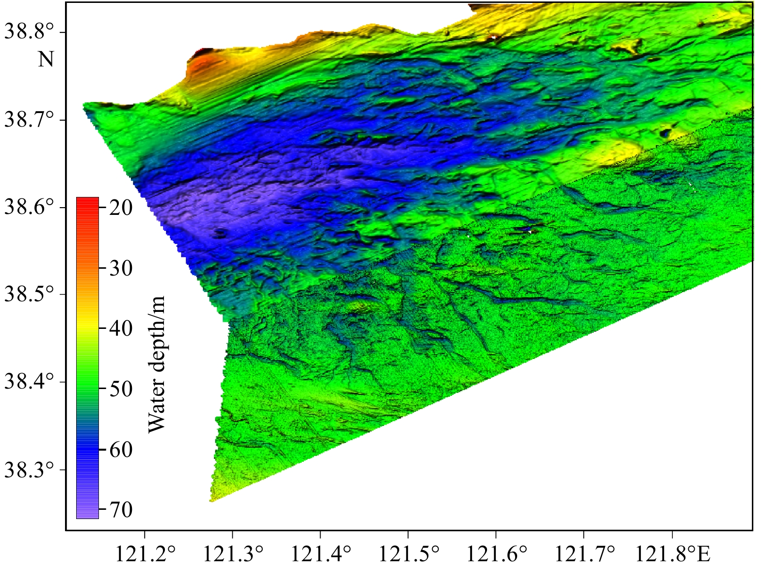
The latest high-resolution multi-beam data revealed a seafloor pockmark field in the central portion of the shelf plain. The pockmark field developed on the flat seafloor to the south of the Changshan Island, with a length of 60 km from east to west and 80 km from north to south. The water depth of the pockmark field is 50–55 m, with the terrain slightly inclined to the south. Detailed geomorphological characteristic of the pockmarks can be distinguished using the multibeam terrain model, the pockmarks in plan-view appear circular, elliptical, and irregular, with km-scale diameters and shallow depths (0.1–2.5 m) (Fig. 9). There are domes like structures in most of the pockmarks, and they are immature relative to fully developed pockmarks. The entire pockmark field covers an area of 3 200 km2; it is rare to have a relatively large shallow-water pockmark cluster on a continental shelf. The appearance of pockmarks is usually related to fluid seepage from the seabed (Judd and Hovland, 2007; Giuliana et al., 2017). Acoustic and biological evidence has confirmed the presence of active fluid in some pockmarks (Liu et al., 2019). Acoustic anomalies displayed on high-resolution sub-bottom profile images suggest that the migration and accumulation of shallow gas caused the formation of these features (Wang et al., 2018). Shallow methane gas and fresh groundwater are considered to be the likely fluids resulting in seepage in the NYS basin (Chen et al., 2017). According to the seismic profile, the top surface sediment layer is missing in the center of NYS where the pockmark field occur, while in the southern and northern offshore areas the top surface layer can reach tens of meters in thickness (Fig. 10). The widely developed paleo-channels in this area may provide the pathway and storage space for fluid migration and gathering.
Figure
9.
Three-dimensional topographical surface of the pockmark field.
Figure
10.
Accumulative shoal (mud wedge) around the Shandong Peninsula. This image shows that the mud shoal platform wraps around the eastern end of the Shandong Peninsula, extends from the Bohai Strait to Chengshantou, and turns to southwards into the South Yellow Sea. The overall trend of the subaqueous shoal is consistent with the coastal current.
4.3
Accumulative platform around the Shandong Peninsula
The offshore area to the north of the Shandong Peninsula is an underwater platform developed along the coastline. The platform is 60 km wide, comprising a flat top of 45 km and a steep side of 15 km. The water depth above the flat top range from 19 m to 22 m with an average slope less than 0.1°; and the water depth above the steep side ranges from 22 m to 44 m with an slope of 0.04°–0.08°. The seafloor turns into flat plain where water depth deeper than 44 m. This platform is a part of the mud wedge which extends from the Bohai Strait to Chengshantou, wraps around the eastern end of the Shandong Peninsula, and extends southwards into the South Yellow Sea (Alexander et al., 1991; Liu et al., 2004; Yang and Liu, 2007). Seismic profiles of this platform show that it is a prominent clinoform with a “Ω” profile, and is 15−40 m in thickness, thinning offshore to <1 m. This clinoform deposit directly overlies the postglacial transgressive surface; the surface sediments are muddy silt and silty sand, which are the Huanghe River materials transported by the coastal current of the Shandong Peninsula. This mud wedge feature is also considered to be the distal subaqueous deltaic lobe of the Huanghe River (Liu et al., 2004; Yang and Liu, 2007). Several studies have confirmed that this clinoform began to form during the middle-Holocene highstand under a relatively stable sea level; subsequently, it has mainly been deposited by resuspended Huanghe River sediments carried down by the coastal current, interacting with local waves, tides, and upwelling (Yang and Liu, 2007; Liu et al., 2009).
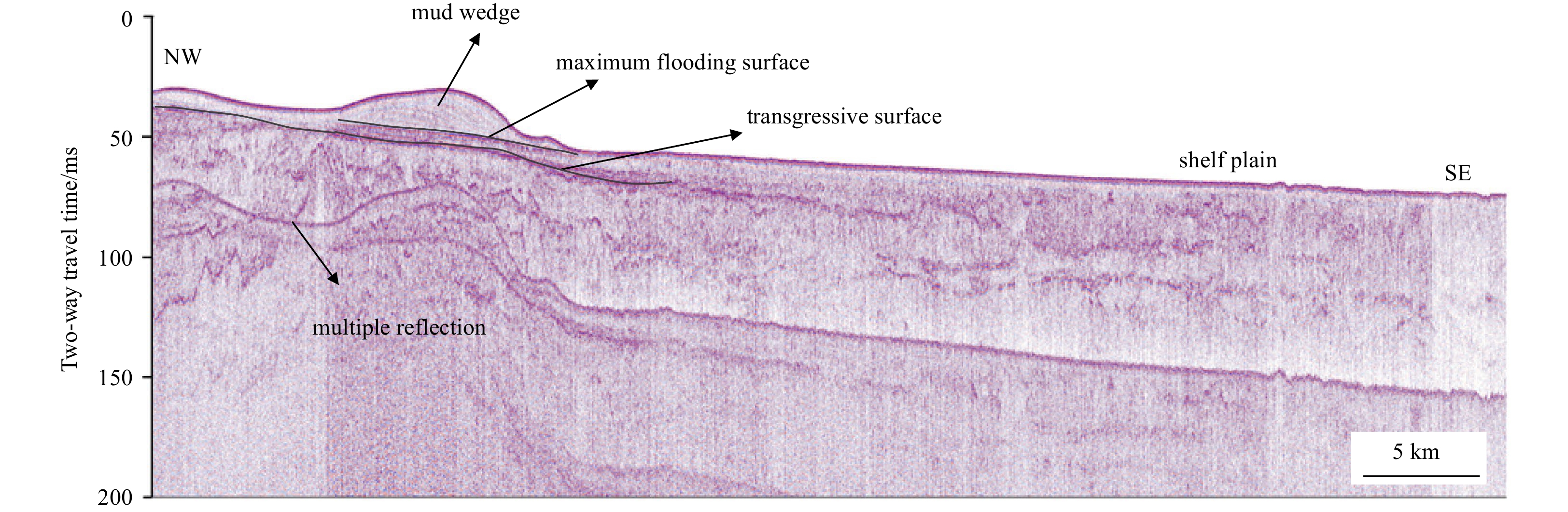
Seismic profile 3 shows the overall geomorphological structure of the NYS (Fig. 11). On the upper southwest side of the profile, the mud wedge off the Shandong Peninsula shows the reflection characteristics of high-angle, oblique, near-transparent bedding with a thickness of ~20 m, then thins out northeastwards towards the central region of the NYS. In the underlying strata, there are transgressive deposits with 2–3 m-thick horizontal bedding, and underneath are late Pleistocene deposits, including paleo-channel and paleo-lake deposits. The central part of the profile comprises the flat shelf plain, where Holocene deposits are very thin. In the underlying late Pleistocene deposits, it is difficult to trace any continuous strata because of the extensive development of shallow gas. There are seafloor pockmarks and subaqueous sand ripples in the northeast part of the accumulative plain. At the northeast end of the profile, the topography becomes shallower, gradually extending to the south of the Changshan Archipelago.
Figure
11.
Seismic profile 3. This profile runs from the mud wedge accumulations off the northern Shandong Peninsula and passes from southwest to northeast through the shelf accumulative plain in the mid-west region of the North Yellow Sea, before extending to the Changshan Archipelago.
4.4
Detailed seafloor geomorphological map of the western region of the NYS
By drawing the newly detected seafloor geomorphological units and elements mentioned above, and adding these to the existing geomorphological map of the area(Lin, 1989; Cai et al., 2013; Li et al., 2020), a detailed full-coverage seafloor geomorphological map of the NYS can be obtained (Fig. 12). In this map, geomorphological details such as subaqueous shoals, scour troughs surrounding islands, and the seafloor pockmark field in the western region of the NYS are depicted as a whole based on the latest high-resolution survey data. In the identification and classification of each geomorphological feature, morphology and genesis are considered as the main factors. When compiling the geomorphological map, colored legends were used to make the map easier to read.
Figure
12.
Geomorphological map of the North Yellow Sea (NYS). This map was compiled by referring to existing geomorphological maps (Lin, 1989; Geng, 1981; Liu et al., 2005; Cai, 2013; Li et al., 2020); the data obtained herein were used in the construction of the western part of the NYS.
As a shallow continental shelf sea, the NYS represents a typical accumulative plain. In most areas of the NYS, the seafloor surface is covered by loose sediments of varying thicknesses; exceptions are the bedrock island outcrops in the Changshan Archipelago and Bohai Strait. Under the abundant supply of terrigenous sediments, widespread depositional geomorphological units have been formed in both the northern and southern offshore areas of the NYS. In the north of the NYS, tidal sand ridges extend 50 km offshore, and the edge of the accumulative shoal near the southern Liaodong Peninsula reaches 40 km offshore. In the south of the NYS, the average width of the mud wedge surrounding the Shandong Peninsula is 40 km. These geomorphological units are characterized by positive topography, high gradient, diverse shape, and thick sediments. However, in the center of the NYS, sediment sources decrease, and the geomorphological units are characterized by negative topography, low gradient, and thin sediments.
5.
Discussion
5.1
Factors affecting seafloor geomorphology in the NYS
Mapping the seabed in the detail presented herein provides an opportunity to propose explanations for the form and distribution of geomorphological units and elements in terms of likely formative mechanisms and processes. Here we propose four main factors as potential influences on the geomorphological form of the NYS seafloor. These are the tectonic activities within the NYS basin, abundant sediment sources, nearshore current systems, and sea-level fluctuation.
On the whole, the seafloor geomorphological features of the NYS are relatively young with almost no visible traces of large faults or other tectonic structures on the surface; hence, tectonic factors do not seem to be directly reflected in the appearance of the geomorphological features (Lin, 1989; Xu, 1997; Cai, 2013). However, it is evident that the macroscopic geomorphological pattern of the seafloor is controlled by geotectonics. The current seafloor geomorphology of the NYS is developed on an extremely thick Cenozoic sedimentary layer, and the overall subsidence of the NYS basin since the late Cenozoic has laid the foundation for the shelf accumulative plain in the central region of the NYS (Geng, 1981; Zheng, 1991). The Jiaoliao Uplift and its corresponding terrestrial mountains and hills control the shoreline contours and sea‒land pattern of the NYS. These structures naturally extend underwater to form the basement for the development of the large subaqueous accumulations off the Liaodong Peninsula and Shandong Peninsula.
The western region of the NYS is a deposition center, which is affected by the large quantity of sediment carried by surrounding rivers (e.g, Huanghe River, Yalu River and other small rivers; Wang et al., 2009). The thickness of the Holocene sedimentary layer is larger than 40 m immediately offshore, and it gradually thins from the nearshore to the center of the NYS. As shown in the seismic profile, the subaqueous mud wedge adjacent to Shandong Peninsula and subaqueous shoals adjacent to Liaodong Pennisula are Holocene hightand deposits; provenance analysis shows that these sediments were mainly derived from the Huanghe River and Yalu River (Liu et al., 2007; Chen et al., 2013), which indicates that these geomorphological features are the result of substantial material inputs into marine areas by coastal rivers. The offshore continental shelf is the main destination for the transportation of terrigenous sediments to the sea, and there is also a complex hydrodynamic system in this region. Tidal currents, waves, and residual currents provide strong erosion and transportation capacity to the seabed, and are the main external forces driving the formation of erosion troughs and sediment redistribution and deposition. The trends of the subaqueous accumulations of the Liaodong Peninsula and Shandong Peninsula are consistent with the directions of coastal currents, indicating that the shaping of submarine geomorphological characteristics is closely related to the influence of coastal tidal current systems.
Consistent with the frequently changing global climate, the sea level in the East China Sea has fluctuated several times during the Quaternary, and corresponding multi-stage sedimentary strata have been formed (Butenko et al., 1985; Zheng, 1991; Chen et al., 2011). The continental shelf of the Yellow Sea was exposed during the Last Glacial Maximum (LGM; approximately 20 ka BP) when the sea level was 120 m below modern sea level (Qin, 1989). During the period of low sea level, the seafloor of the NYS was completely exposed as land, and thick offshore accumulative topography, such as the Shandong clinoform and Liaodong Peninsula subaqueous shoal, had not been formed. The major portion of the Shandong clinoform formed during Holocene sea-level highstands in the last 7 ka (Yang and Liu, 2007). The rise of post-LGM sea level has clearly played a critical role in the development of the Holocene offshore accumulative shoals. In addition, the fluctuation of sea level resulted in the seabed in the study area being sequentially exposed as land and submerged by sea water, forming complex sedimentary strata containing multi-stage paleo-channels, this is also clearly a key factors affecting the geomorphological evolution of the NYS.
5.2
Formation mechanisms of the two accumulative geomorphological units in the study area and inspirations for the geomorphological evolution of the continental shelf
The study of on the long-distance transportation of sediments from estuaries by large-scale river system and the formation of large-scale alongshore clinoform deposits far from their source has attracted considerable attention (Nittrouer et al., 1996; Liu et al., 2007). The mud wedge and subaqueous shoal in the study area are typical distal deposits of the Huanghe River and the Yalu River (Chen et al., 2013; Liu et al., 2007). Although both of the accumulative geomorphological units (adjacent to the Liaodong Peninsula and surrounding the Shandong Peninsula) are Holocene deposits, their geomorphological features, material compositions, and formation mechanisms are different, and these represent distinct geological processes.
The subaqueous accumulative geomorphological unit off the Liaodong Peninsula includes several tongue-shaped shoals with maximum widths of 8 km and thicknesses of 5−15 m; these are much smaller than the mud wedge surrounding the Shandong Peninsula, which has an average width of 6 km and a maximum thickness of 40 m. From the aspect of material composition, the deposits of the Liaodong Peninsula shoal mainly derive from the Yalu River and are driven by the Liaonan Coastal Current (LCC), and the particle size ranges from sand to muddy silt (Chen et al., 2013; Wang et al., 2009). In contrast, the main sediment of the Shandong Peninsula shoal is muddy silt, which comes from the long-distance transportation of the Huanghe River (Liu et al., 2002, 2004); fine materials deposited on the mud wedge have been driven by the Shandong Coastal Current (SDCC) since the mid-Holocene (Liu et al., 2002; Yang and Liu, 2007). The flow velocity of the SDCC is much lower than that of the LCC, and it remains stable and uniform from west to east. The resulting deposits are almost parallel to the shoreline and contain fine-grained clayey silt or mud, which indicates the sedimentation of fine-grained materials in a weak hydrodynamic environment.
Therefore, the two accumulative geomorphological units are formed under the action of different dynamic processes. Deep and wide scour troughs, containing various particle sizes, developed between the tongue-shaped shoals off the Liaodong Peninsula coast, representing a strong hydrodynamic environment. In contrast, the single, simple geomorphological element with fine particles off the Shandong Peninsula indicates a relatively weak and simple hydrodynamic environment. The geomorphology of any region is the result of wide-ranging the Earth surface processes, and changes dynamically—the geomorphology in any period represents an instantaneous record of the evolutionary history of the Earth. The offshore continental shelf is the main area for the transportation of terrigenous sediments to the sea. Large quantities of sediments carried by rivers flowing into the sea are important material sources for the formation of modern sedimentary geomorphology. In addition, there are complex tidal current systems in the offshore region, which provide strong erosivity to the seafloor in local areas under the combined effects of waves, tidal currents, and circulations. Strong tidal dynamic systems are the main external force driving the formation of erosion troughs and the redistribution and deposition of materials. On the offshore continental shelf with abundant material sources, Holocene sedimentation is the primary process that determines the formation and evolution of seafloor geomorphology, while extensive strong tidal current systems and abundant sediment sources are critical external forces and essential conditions for sculpting offshore seafloor geomorphology.
6.
Conclusions
(1) A detailed full-coverage seafloor geomorphological map of the North Yellow Sea was constructed by adding newly detected seafloor geomorphological units and elements to exist geomorphological maps of the study area. In this map, the geomorphological elements discovered by multi-beam sonar in the western region of the NYS, such as subaqueous shoals, scour troughs surrounding islands, and a seafloor pockmark field are depicted in detail for the first time.
(2) Modern sedimentation is the primary process that determines the formation and evolution of seafloor geomorphology, while extensive strong tidal current systems and abundant sediment sources are critical external forces and essential conditions for sculpting offshore seafloor geomorphology. The rise of post-LGM sea level has also played a critical role in the development of the Holocene offshore accumulative shoals.
(3) Two accumulative geomorphological units in the western region of the NYS exhibit different geomorphological features, material compositions, and formation mechanisms. They also represent two different depositional and geomorphological processes. Several small scale tongue-shaped shoals and deep scouring troughs with various sediment particle sizes off the Liaodong Peninsula coast are representative of a strong hydrodynamic environment. In contrast, single large scale subaqueous clinoform with fine particle sizes off the Shandong Peninsula indicates a relatively weak and simple hydrodynamic environment.
Acknowledgements:
The data acquisition was supported by the comprehensive voyage of Chinese coastal seas of First Institute of Oceanography, Ministry of Natural Resources. We thank the crew and shipboard scientific team of XIANG YANG HONG 18 for their excellent support during the expedition. We are grateful to two anonymous reviewers for helpful comments and suggestions which improved our work. We also thank David Wacey from Liwen Bianji (Edanz) (www.liwenbianji.cn) for editing the English text of the draft of this manuscript.
Alexander C R, DeMaster D J, Nittrouer C A. 1991. Sediment accumulation in a modern epicontinental-shelf setting: the Yellow Sea. Marine Geology, 98(1): 51–72. doi: 10.1016/0025-3227(91)90035-3
Butenko J, Milliman J D, Ye Yincan. 1985. Geomorphology, shallow structure, and geological hazards in the East China Sea. Continental Shelf Research, 4(1–2): 121–141
Cai Feng, Cao Chao, Zhou Xinghua, et al. 2013. Submarine Topography and Morphology of Offshore China Sea (in Chinese). Beijing: China Ocean Press
Chen Xiaohui. 2014. Sedimentary stratigraphic structure and provenance environmental evolution in the North Yellow Sea during the late Quaternary (in Chinese)[dissertation]. Qingdao: The Institute of Oceanology, Chinese Academy of Sciences
Chen Xiaohui, Li Rihui, Xu Xiaoda. 2011. Shallow seismic records and late Pleistocene Stratigraphy of the North Yellow Sea. Marine Geology & Quaternary Geology, 31(3): 17–22
Chen Xiaohui, Li Tiegang, Zhang Xunhua, et al. 2013. A Holocene Yalu River-derivered fine-grained deposit in the southeast coastal area of the Liaodong Peninsula. Chinese Journal of Oceanology and Limnology, 31(3): 636–647. doi: 10.1007/s00343-013-2087-1
Chen Shanshan, Sun Qiliang, Lu Kai, et al. 2017. Anomalous depressions in the northern Yellow Sea Basin: evidences for their evolution processes. Marine and Petroleum Geology, 84: 179–194. doi: 10.1016/j.marpetgeo.2017.03.030
Cheng Peng, Gao Shu. 2000. Net sediment transport patterns over the northwestern Yellow Sea, based upon grain size trend analysis. Oceanlogia Et Limnologia Sinica, 6(31): 604–615
Chough S K, Lee H J, Yoon S H. 2000. Yellow Sea. In: Chough S K, Lee H J, Yoon S H, eds. Marine Geology of Korean Seas. 2nd ed. Amsterdam: Elsevier, 47–144
Geng Xiushan. 1981. The geomorphological features and forming factors of submarine relief in the Bohai Sea and the Yellow Sea. Acta Geographica Sinica, 36(4): 423–434
Gensac E, Martinez J M, Vantrepotte V, et al. 2016. Seasonal and inter-annual dynamics of suspended sediment at the mouth of the Amazon River: The role of continental and oceanic forcing, and implications for coastal geomorphology and mud bank formation. Continental Shelf Research, 118: 49–62. doi: 10.1016/j.csr.2016.02.009
Giuliana p, Stenfan B, Daniel J F, et al. 2017. An intergrated view of the methane system in the pockamrks at Vestnesa Ridge, 79°N. Marine Geology, 390: 282–300. doi: 10.1016/j.margeo.2017.06.006
Judd A G, Hovland M. 2007. Seabed Fluid Flow, the Impact on Geogogy, Biology, and the Marine Environment. London: Cambridge University Press
Lee H J, Chough S K. 1989. Sediment distribution, dispersal and budget in the Yellow Sea. Marine Geology, 87(2–4): 195–205
Li Rihui, Chen Xiaohui, Wang Zhongbo. 2020. Regional Geology of the North Yellow Sea (in Chinese). Beijing: China Ocean Press
Li Yan, Li Anchun, Huang Peng, et al. 2014. Clay minerals in surface sediment of the North Yellow Sea and their implication to provenance and transportation. Continental Shelf Research, 90: 33–40. doi: 10.1016/j.csr.2014.01.020
Li Wenyong, Li Dongxu, Xia Bin, et al. 2006. Characteristics of structural evolution in North Yellow Sea Basin. Geoscience, 20(2): 268–276
Li Wenyong, Zeng Xianghui, Wang Xinguo, et al. 2009. Analysis of structural kinematics of North Yellow Sea Basin. Earth Science Frontiers, 16(4): 74–86
Lin Meihua. 1989. The sybmarine geomorphological zones and geomorphological types in the Huanghai Sea. Marine Sciences, 11(6): 7–15
Liu Xiaoyu, Feng Xiuli, Sun Yongfu, et al. 2019. Acoustic and biological characteristics of seafloor depressions in the North Yellow Sea Basin of China: active fluid seepage in shallow water seafloor. Marine Geology, 414: 34–46. doi: 10.1016/j.margeo.2019.05.002
Liu Zhongchen, Liu Baohua, Huang Zhenzong, et al. 2005. Seafloor Topography and Geomorphology of Offshore China Sea and Its Adjacent Areas (in Chinese). Beijing: China Ocean Press
Liu J P, Milliman J D, Gao Shu. 2002. The Shandong mud wedge and post-glacial sediment accumulation in the Yellow Sea. Geo-Marine Letters, 21(4): 212–218
Liu J P, Milliman J D, Gao Shu, et al. 2004. Holocene development of the Yellow River’s subaqueous delta, North Yellow Sea. Marine Geology, 209(1–4): 45–67
Liu Jian, Saito Y, Kong Xianghuai, et al. 2009. Geochemical characteristics of sediment as indicators of post-glacial environmental changes off the Shandong Peninsula in the Yellow Sea. Continental Shelf Research, 29(7): 846–855. doi: 10.1016/j.csr.2009.01.002
Liu Jian, Saito Y, Wang Hong, et al. 2007. Sedimentary evolution of the Holocene subaqueous clinoform off the Shandong Peninsula in the Yellow Sea. Marine Geology, 236(3–4): 165–187
Miao Fengmin, Li Guangtian, Fu Wenxia, et al. 1995. Preliminary study of the sedimentary environments in the sea area around Changshan Islands of the North Yellow Sea. Marine Geology & Quaternary Geology, 15(1): 131–141
Milliman J D, Syvitski J P M. 1992. Geomorphic/tectonic control of sediment discharge to the ocean: the importance of small mountainous rivers. The Journal of Geology, 100(5): 525–544. doi: 10.1086/629606
Nichol S L, Heap A D, Daniell J. 2011. High resolution geomorphic map of a submerged marginal plateau, northern Lord Howe Rise, east Australian margin. Deep-Sea Research Part II: Topical Studies in Oceanography, 58(7–8): 889–898
Nittrouer C A, Kuehl S A, Figueiredo A G, et al. 1996. The geological record preserved by Amazon shelf sedimentation. Continental Shelf Research, 16(5–6): 817–841
Qi Jun, Li Fengye, Song Jinming, et al. 2004. Sedimentation rate and flux of the North Yellow Sea. Marine Geology & Quaternary Geology, 24(2): 9–14
Qiao Shuqing, Shi Xuefa, Wang Guoqing, et al. 2017. Sediment accumulation and budget in the Bohai Sea, Yellow Sea and East China Sea. Marine Geology, 390: 270–281. doi: 10.1016/j.margeo.2017.06.004
Qin Yunshan. 1989. Geology of the Yellow Sea (in Chinese). Beijing: China Ocean Press, 289
Shen Zhongyan, Gao Jinyao, Yang Chunguo, et al. 2013. Characteristics of the Neogene-Quaternary faults in the North Yellow Sea Basin and the Inheritance to the Paleogene faults. Earth Science-Journal of China University of Geosciences, 38(S1): 53–60
Su Jilan,Yuan Yeli. 2005. China Offshore Hydrology. Beijing: China Ocean Press, 1–192
Wang Wei, Li Anchun, Xu Fangjian, et al. 2009. Distribution of surface sediments and sedimentary environment in the North Yellow Sea. Oceanologia et Limnologia Sinica, 40(5): 525–531
Wang Bing, Zhang Xin, Luan Zhendong, et al. 2018. Seabed domes with circular depressions in the North Yellow Sea. Journal of Oceanology and Limnology, 36(6): 2154–2165. doi: 10.1007/s00343-019-7173-6
Xiao Yuzhong, Miao Fengmin. 1995. Characteristics and source of the surface sediments from the offshore water of the Changsan Archipelago. Journal of Oceanography of Huanghai & Bohai Seas, 13(1): 24–30
Xu Dongyu, Liu Xiqing, Zhang Xunhua, et al. 1997. China Offshore Geology. Beijing: Geological Publishing House, 312
Yang Zuosheng, Liu J P. 2007. A unique Yellow River-derived distal subaqueous delta in the Yellow Sea. Marine Geology, 240(1–4): 169–176
Zhang Shuwen, Wang Qingye, Lü Youyu, et al. 2008. Observation of the seasonal evolution of the Yellow Sea cold water mass in 1996–1998. Continental Shelf Research, 28(3): 442–457. doi: 10.1016/j.csr.2007.10.002
Zheng Guangying. 1991. Quaternary Geology of the Yellow Sea (in Chinese). Beijing: Science Press
Taoyu Xu, Jianxing Liu, Shengfa Liu, et al. Understanding the formation mechanism of highly active ridges on East China Sea Shelf during the mid-late Holocene sea-level highstand. Acta Oceanologica Sinica, 2024. doi:10.1007/s13131-024-2397-5
Xiaoyu Liu, Yilan Chen, Chenguang Liu, Qiuhua Tang, Yanhong Wang, Shan Gao. Detailed seafloor geomorphology of the western region of the North Yellow Sea, China: The result of Holocene erosional and depositional processes sculpting the offshore continental shelf[J]. Acta Oceanologica Sinica, 2022, 41(12): 38-47. doi: 10.1007/s13131-022-2060-y
Xiaoyu Liu, Yilan Chen, Chenguang Liu, Qiuhua Tang, Yanhong Wang, Shan Gao. Detailed seafloor geomorphology of the western region of the North Yellow Sea, China: The result of Holocene erosional and depositional processes sculpting the offshore continental shelf[J]. Acta Oceanologica Sinica, 2022, 41(12): 38-47. doi: 10.1007/s13131-022-2060-y
Figure 1. Rivers flowing into the Yellow Sea together with the seawater circulation model (Yang and Liu, 2007; Su and Yuan, 2005; Qiao et al., 2017) (a); mean grain size ($\varPhi $) of seafloor surface sediments in the North Yellow Sea (modified after Wang et al. (2009); Li et al. (2014)) (b). YSWC: Yellow Sea Warm Current; YSCC: Yellow Sea Coastal Current; NYSC: North Yellow Sea Circulation; LCC: Liaonan Coastal Current; BCC: Bohai Coastal Current; YLR: Yalu River; DYR: Dayang River; ZHR: Zhuanghe River; BLR: Biliu River; DSR: Dengsha River; DTR: Datong River; HJR: Hanjiang River; JJR: Jinjiang River; LHR: Luanhe River; HR: Haihe River; HHR: Huanghe River; WHR: Waste Huanghe River; CHJR: Changjiang River.
Figure 2. Seafloor topography of the North Yellow Sea. The lines in this figure are water bathymetric contours, and the marked numbers are the corresponding water depth values.
Figure 3. Dynamic tidal geomorphological unit off the south coast of the Liaodong Peninsula. This image shows tongue- and mound-shaped subaqueous shoals developed to the southwest of the islands and scouring troughs surrounding the islands. The trend of the subaqueous shoals is consistent with the main current direction.
Figure 4. Geomorphological sketch of the seafloor to the south of the Liaodong Peninsula. This image shows the distribution of accumulative shoal, sand ripples and scouring troughs in plan-view.
Figure 5. Seismic profile 1. This profile is NW–SE trending. The left side of this profile comprises two subaqueous clinoforms in close proximity, the Guanglu Island shoal and the Haiyang Island shoal, which have been connected as a whole. The right side of this profile extends towards the SE and reaches the shelf plain in the central region of the North Yellow Sea.
Figure 6. Three-dimensional schematic representation of subaqueous sand ripples. The location of this image is shown in Fig. 4.
Figure 7. Three-dimensional topographical surface of deep tidal-scour troughs in the Laotieshan Channel and erosional troughs on its southeast side.
Figure 8. Seismic profile 2. This profile passes from southwest to northeast through the northwest end of the shelf plain in the central region of the North Yellow Sea and the tidal accumulative shoal off the Changshan Archipelago.
Figure 9. Three-dimensional topographical surface of the pockmark field.
Figure 10. Accumulative shoal (mud wedge) around the Shandong Peninsula. This image shows that the mud shoal platform wraps around the eastern end of the Shandong Peninsula, extends from the Bohai Strait to Chengshantou, and turns to southwards into the South Yellow Sea. The overall trend of the subaqueous shoal is consistent with the coastal current.
Figure 11. Seismic profile 3. This profile runs from the mud wedge accumulations off the northern Shandong Peninsula and passes from southwest to northeast through the shelf accumulative plain in the mid-west region of the North Yellow Sea, before extending to the Changshan Archipelago.
Figure 12. Geomorphological map of the North Yellow Sea (NYS). This map was compiled by referring to existing geomorphological maps (Lin, 1989; Geng, 1981; Liu et al., 2005; Cai, 2013; Li et al., 2020); the data obtained herein were used in the construction of the western part of the NYS.


 DownLoad:


 DownLoad: