2022 Vol. 41, No. 9

Cover
Cover
2022, 41(9)
Abstract:
Contents
2022, 41(9): 1-2.
Abstract:
Articles$Physical Oceanography, Marine Meteorology and Marine Physics
On the role of wave breaking in ocean dynamics under typhoon Matsa in the Bohai Sea, China
Menghan Wang, Zengan Deng
2022, 41(9): 1-18. doi: 10.1007/s13131-022-1995-3
Abstract:
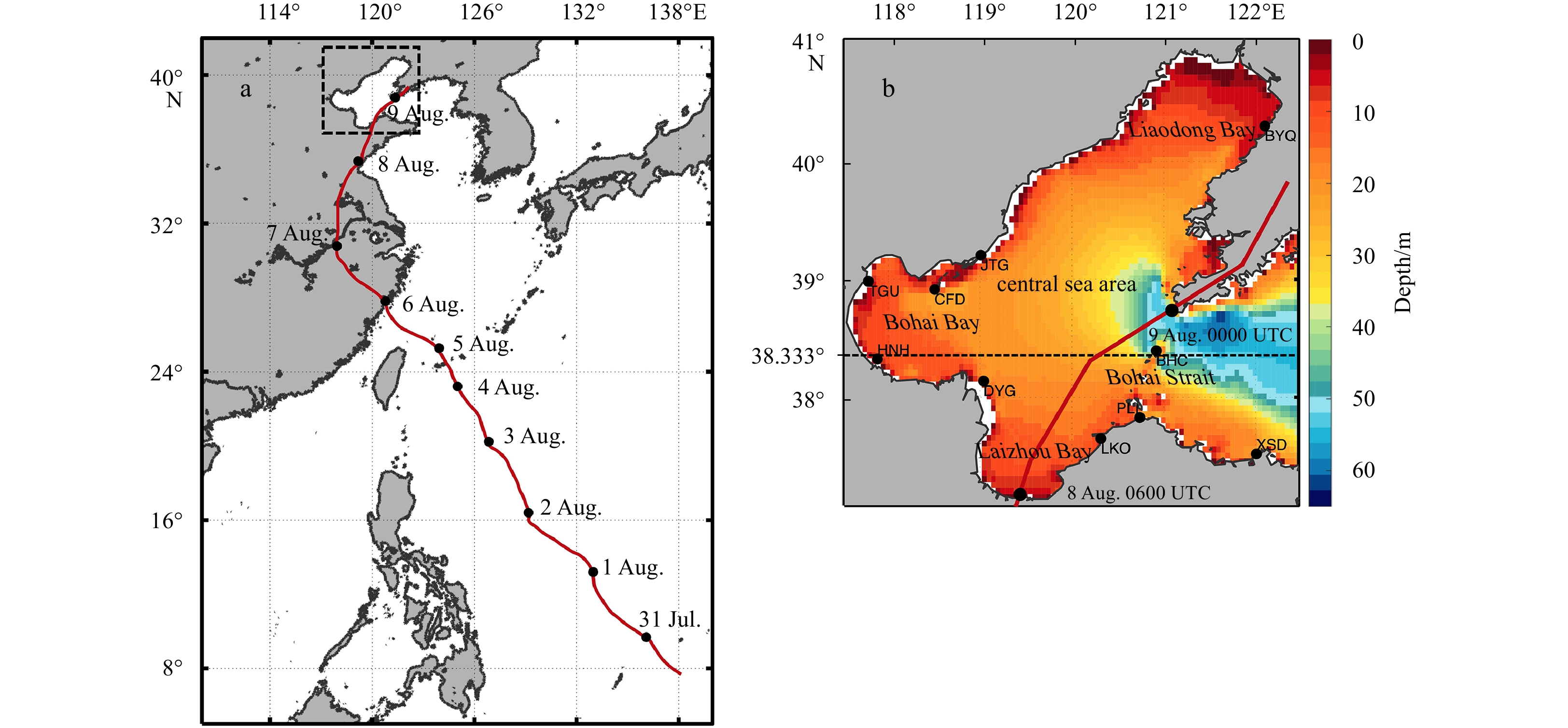
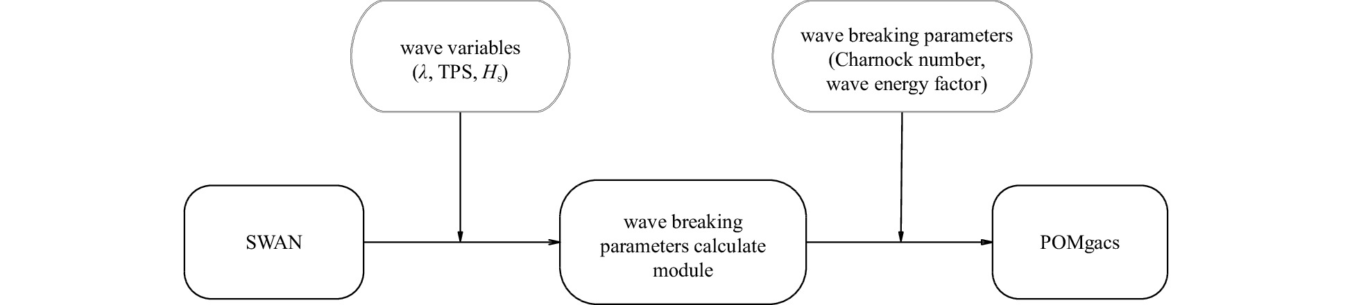
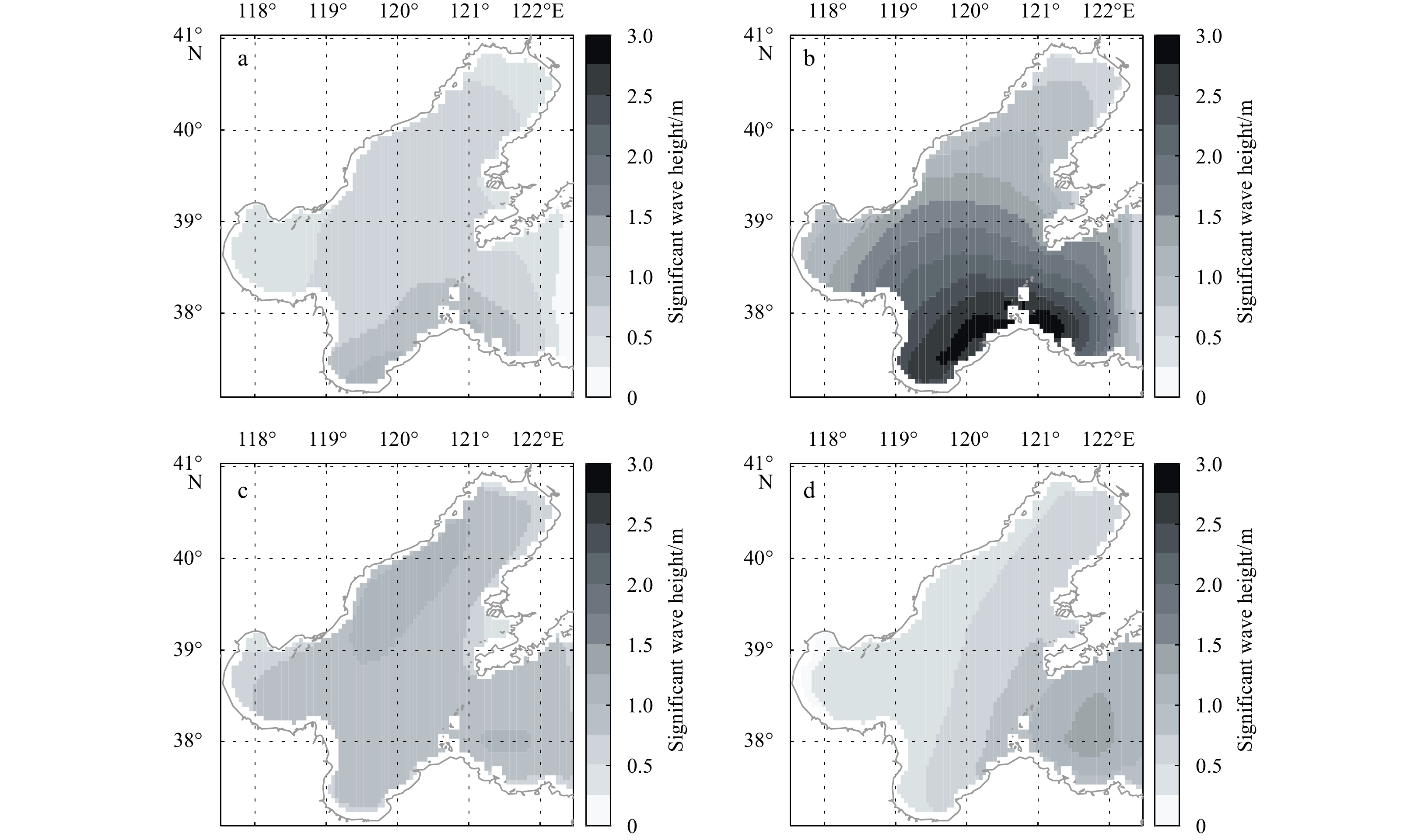
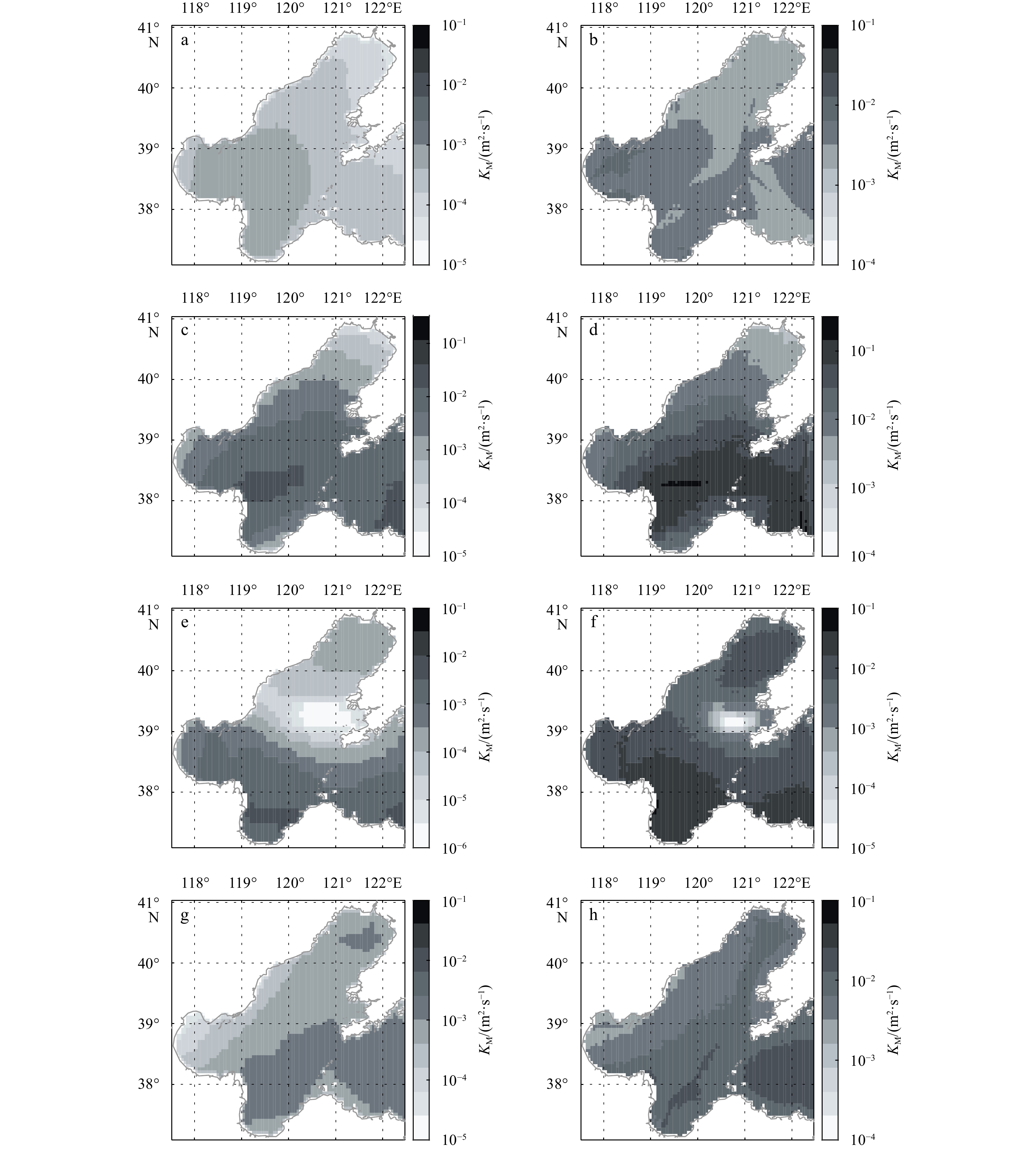
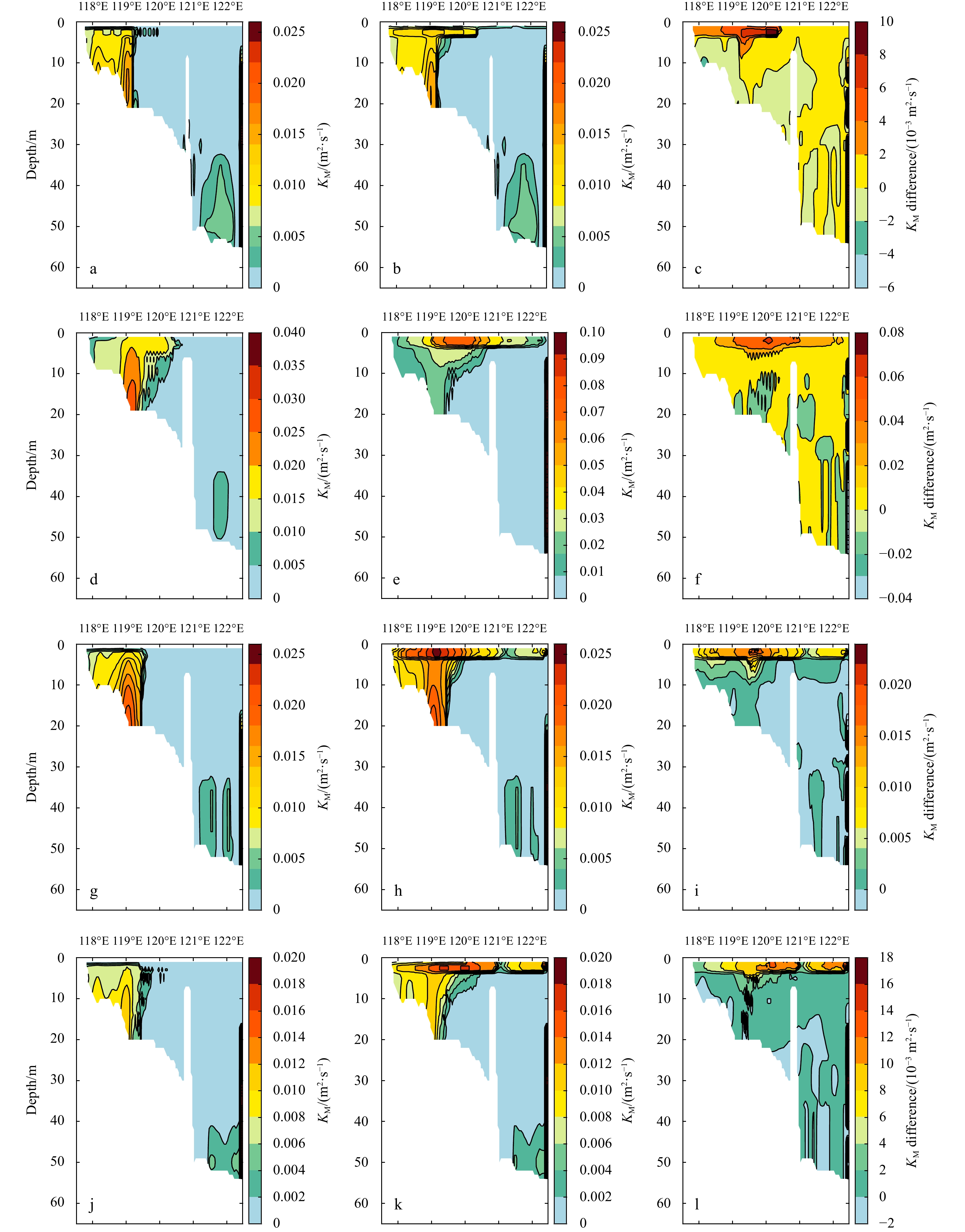
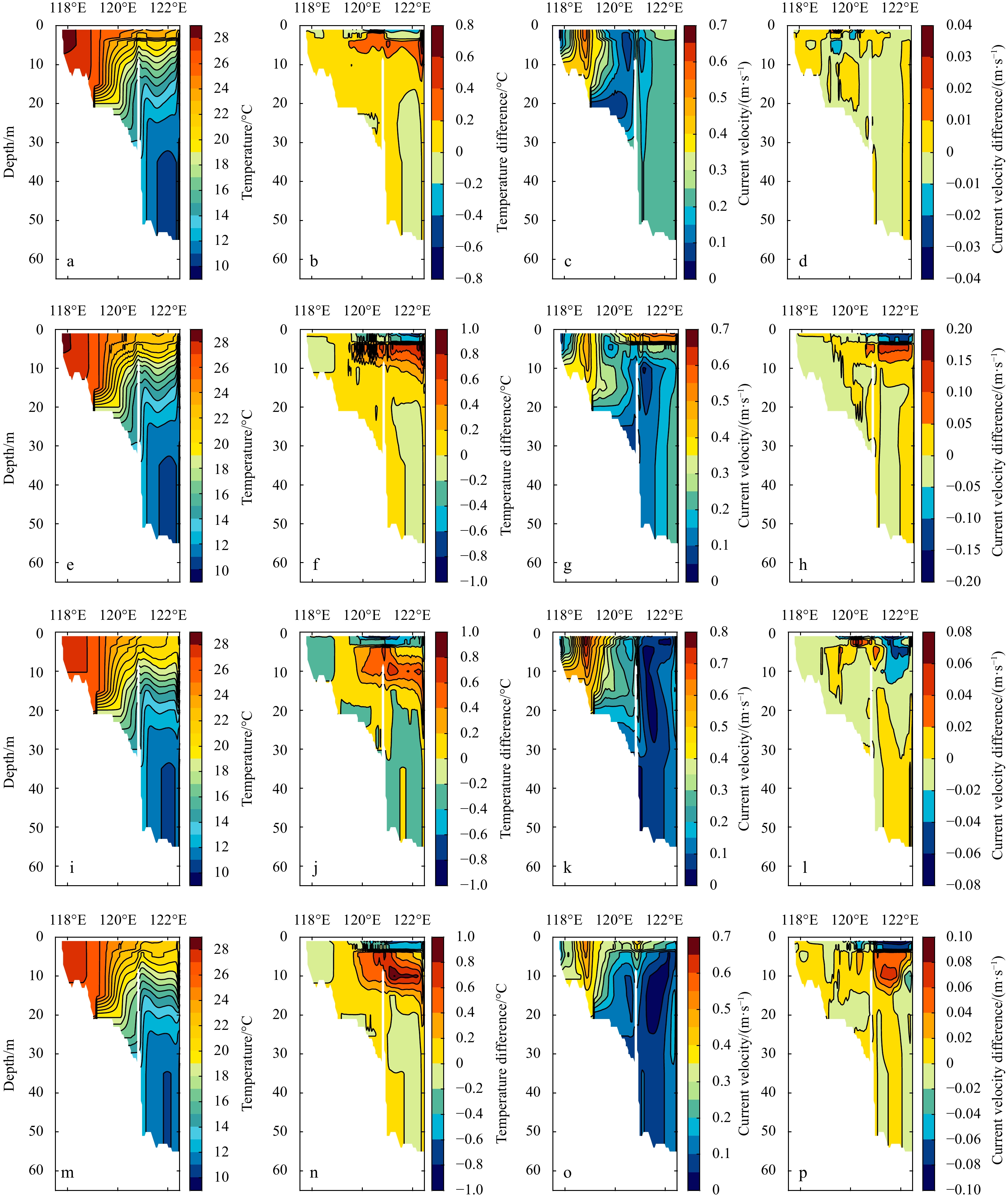
The role of wave breaking (WB) in the ocean dynamics in the Bohai Sea, China under typhoon condition is systematically investigated utilizing a coupled wave-current model. The influences of WB on ocean dynamics and processes (mixing coefficient, temperature, mixed layer depth, and current) during the entire typhoon period (including the pre-typhoon, during-typhoon and after-typhoon stages) are comprehensively detected and discussed. Experimental results show that WB greatly enhances the turbulent mixing at about top 10 m depth under typhoon condition, the increase can be up to 10 times that of the normal weather. At the same time, WB generally strengthens the sea surface cooling by ~1.2°C at the during-typhoon stage, about 3 times that in normal weather. The mixed layer depth, is rapidly increased by ~1.6–3.6 m during typhoon due to WB, particularly, the deepening is stronger in the region from 120.5°E to 121.0°E on account of close to the typhoon eye. In addition, WB renders the current speed more uniformly within the entire depth in the Bohai Sea, the change in speed is ~0.2 m/s, whereas the alternation in current vector is generally opposite to the wind direction except for the typhoon eye region, reflecting that WB has an inhibitory effect on the typhoon-forced current change. The effects of WB on vertical mixing coefficient response to the typhoon rapidly, while the impacts of WB on temperature, and mixed layer depth present hysteretic responses to typhoon. Finally, the mechanisms and distribution characteristics of WB-induced mixing and tidal mixing are compared under typhoon condition.
Contributions of shortwave radiation to the formation of temperature inversions in the Bay of Bengal and eastern equatorial Indian Ocean: A modeling approach
K M Azam Chowdhury, Wensheng Jiang, Changwei Bian, Guimei Liu, Md Kawser Ahmed, Shaila Akhter
2022, 41(9): 19-37. doi: 10.1007/s13131-022-1998-0
Abstract:
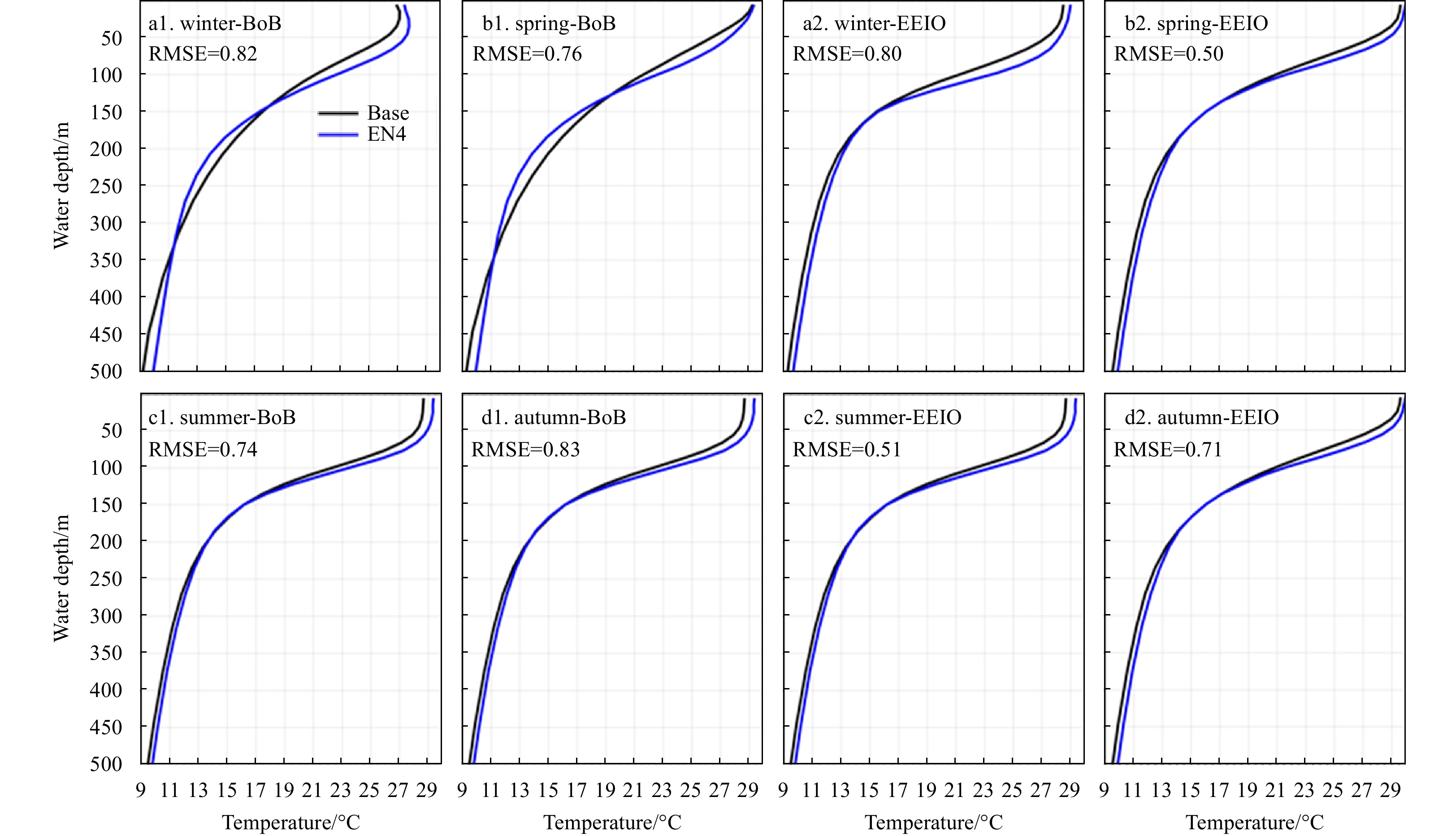
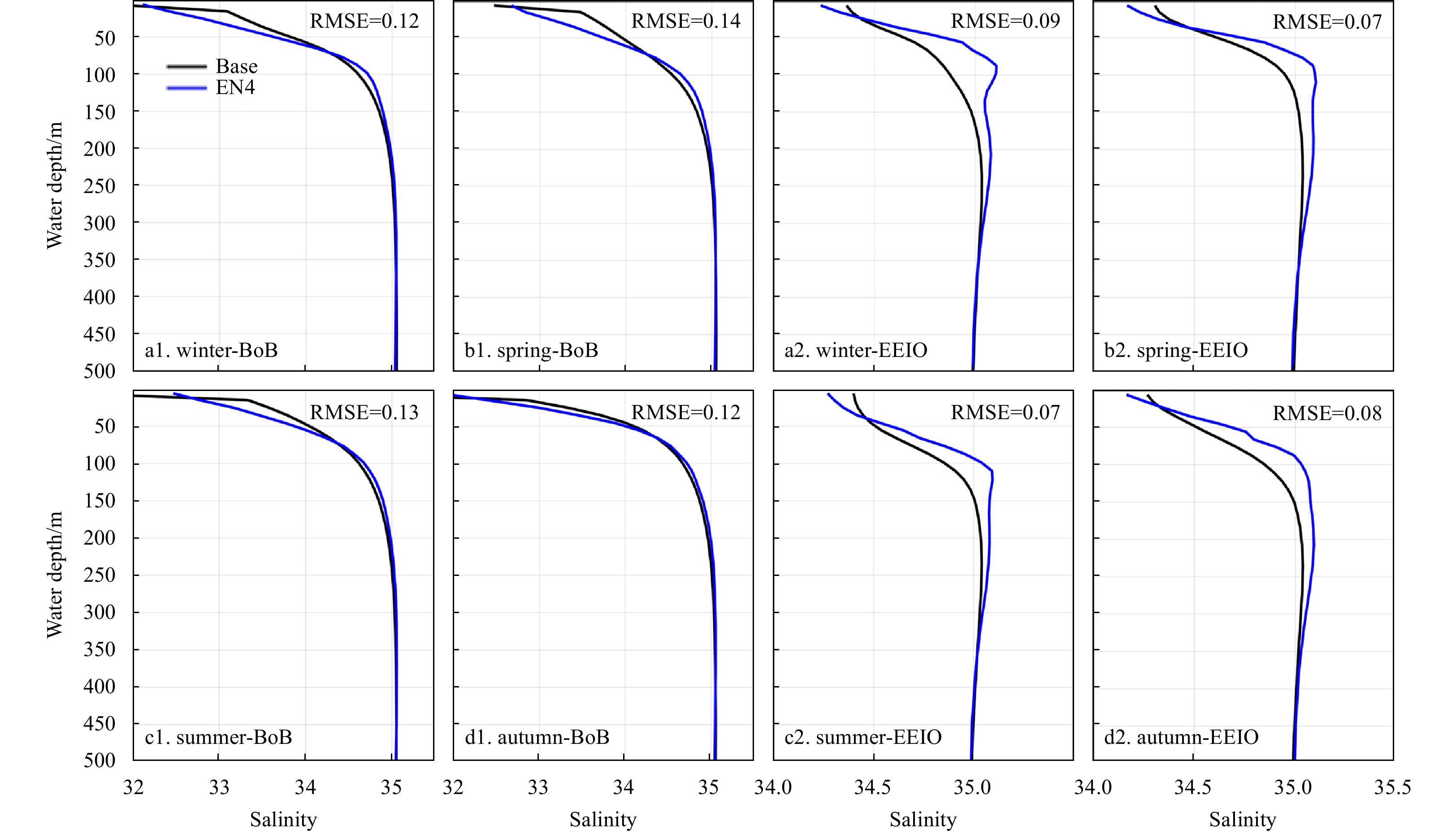
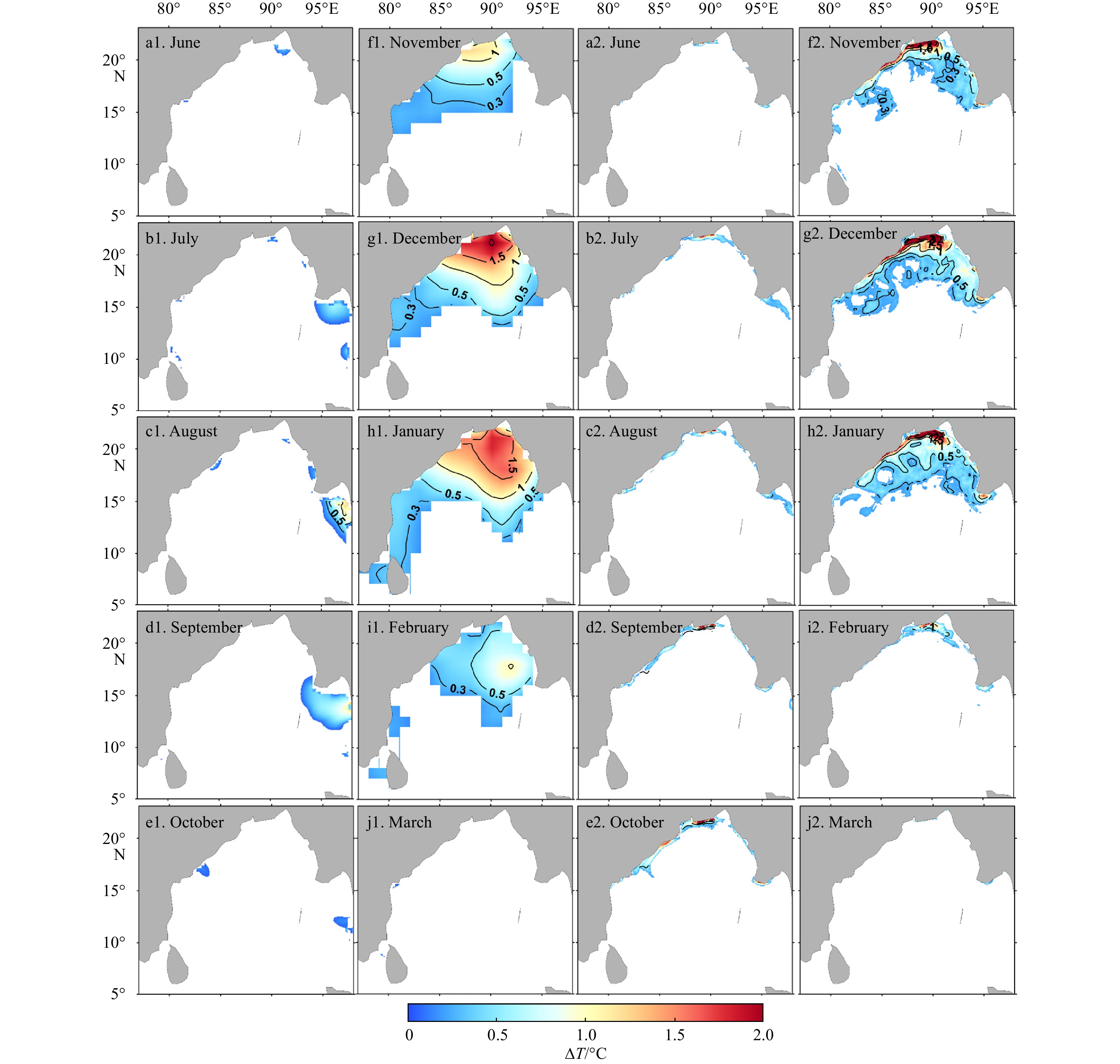
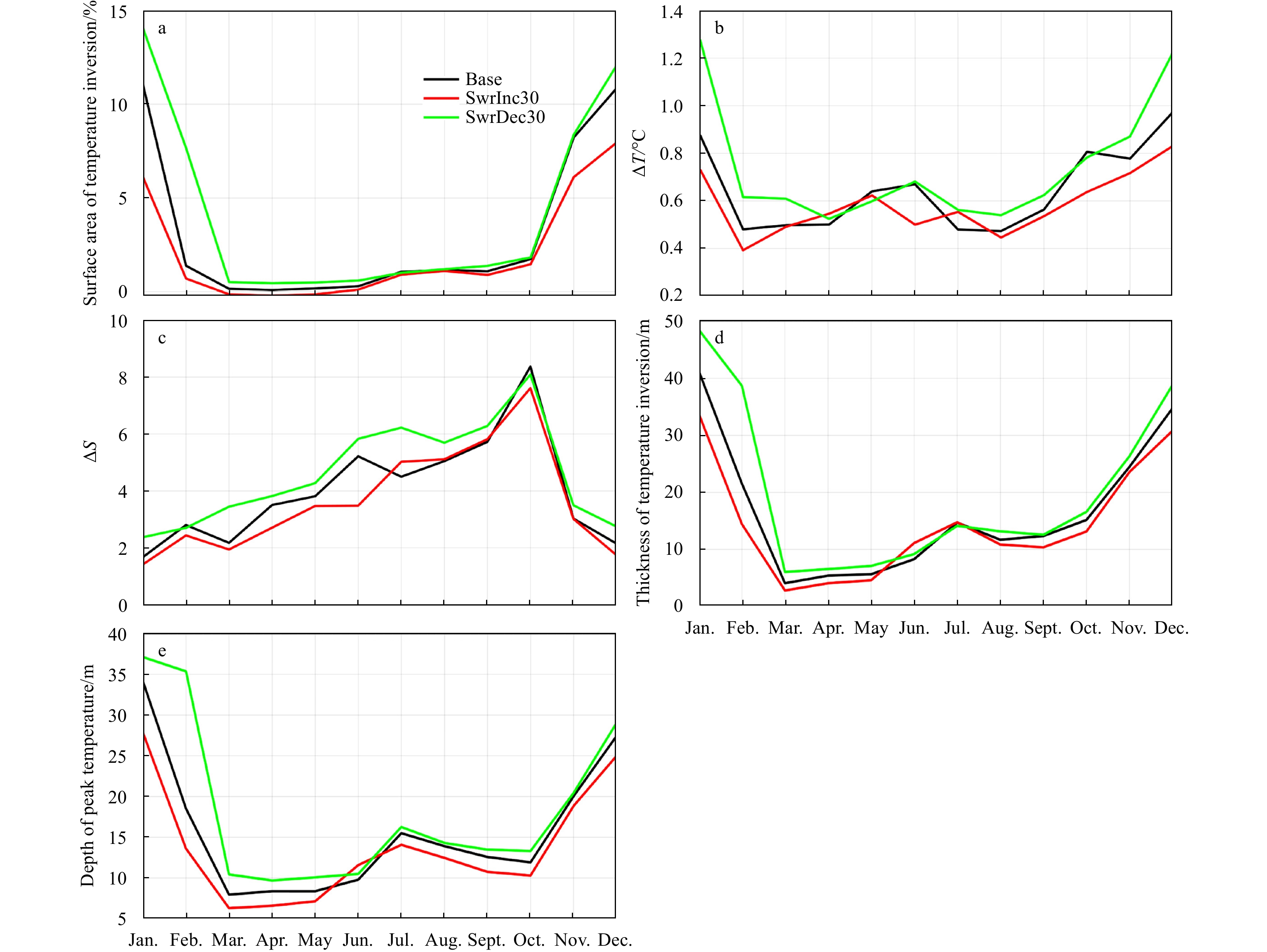
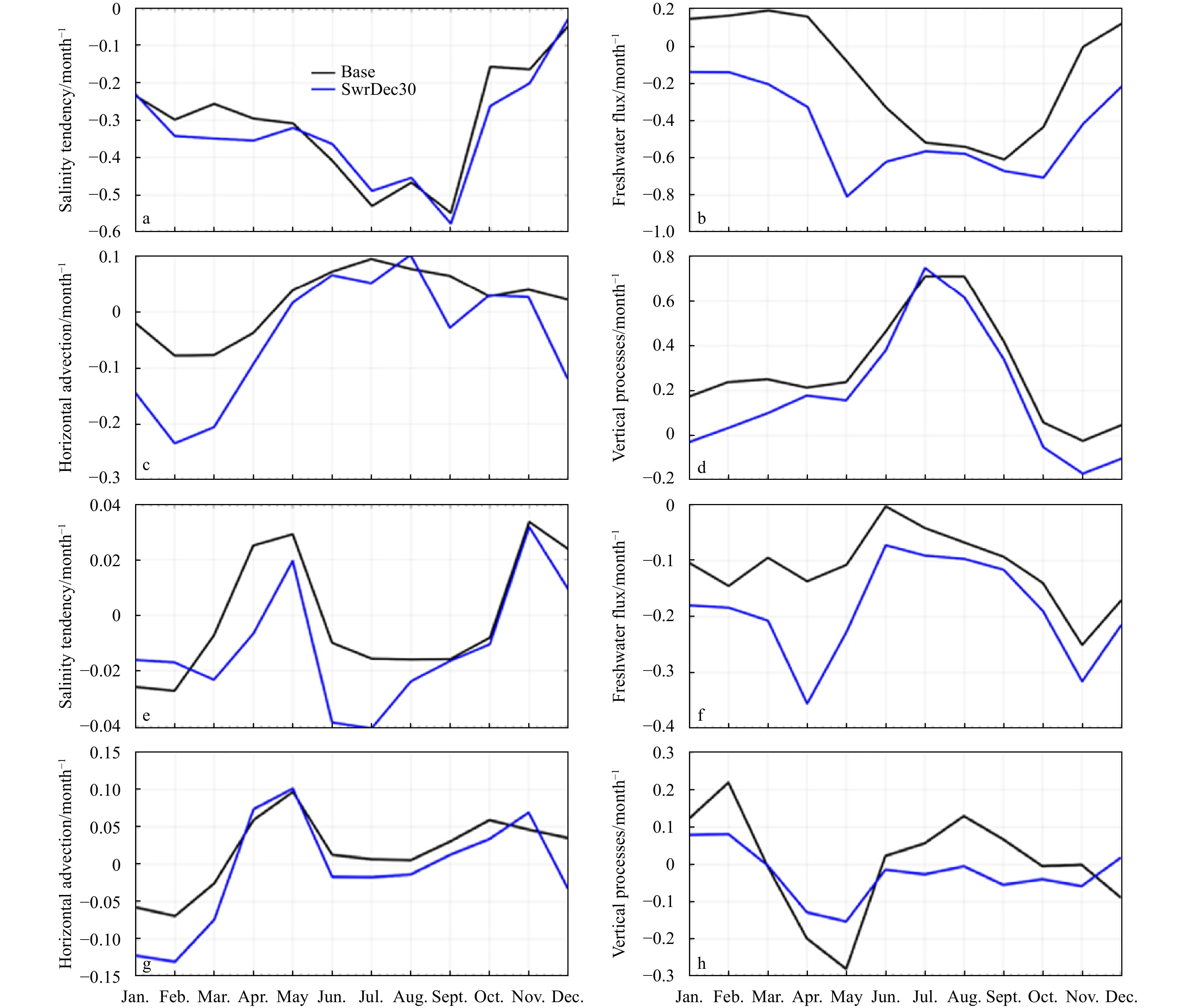
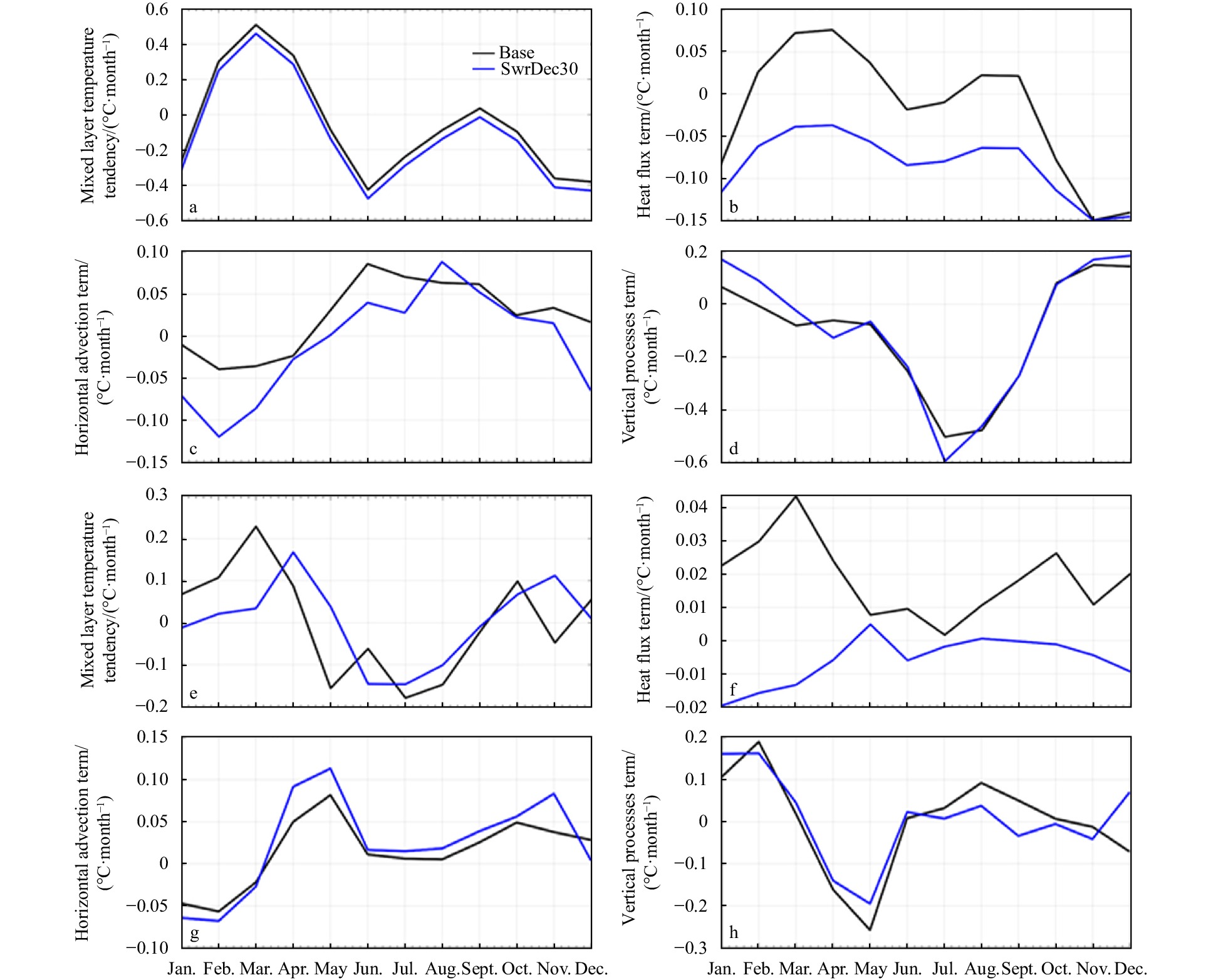
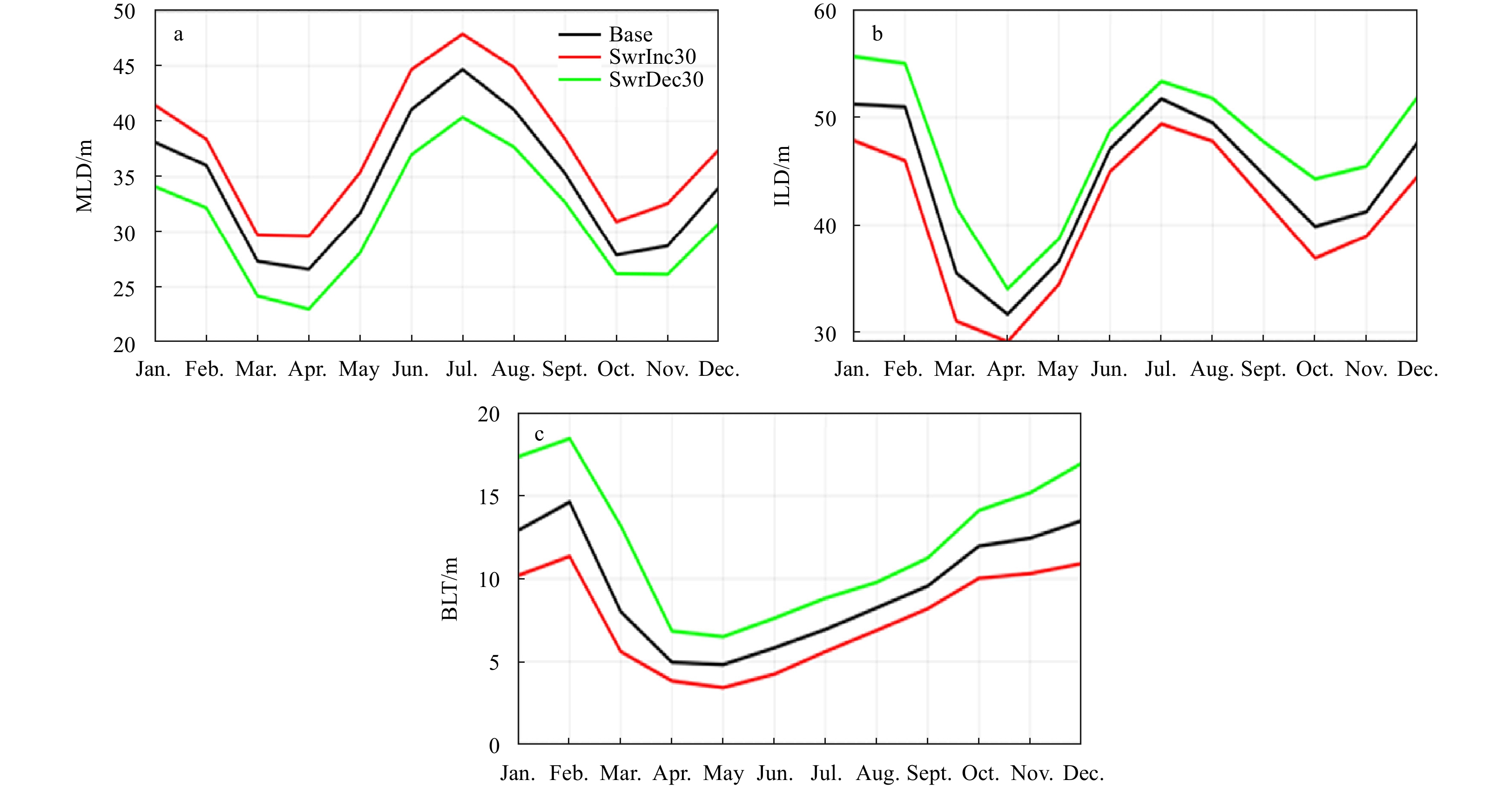
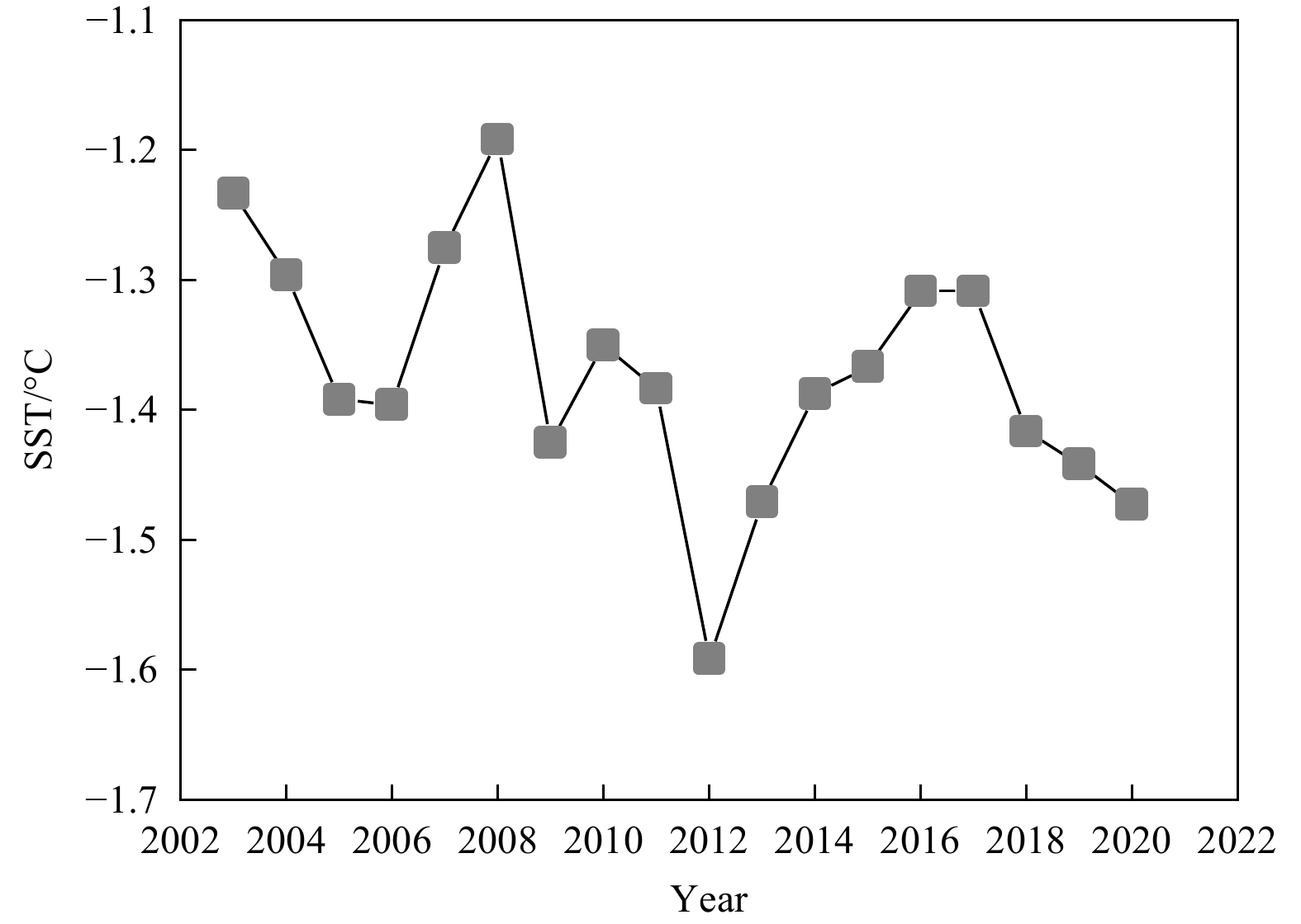
Variations in incoming shortwave radiation influence the net surface heat flux, contributing to the formation of a temperature inversion. The effects of shortwave radiation on the temperature inversions in the Bay of Bengal and eastern equatorial Indian Ocean have never been investigated. Thus, a high-resolution (horizontal resolution of 0.07°×0.07° with 50 vertical layers) Regional Ocean Modeling System (ROMS) model is utilized to quantify the contributions of shortwave radiation to the temperature inversions in the study domain. Analyses of the mixed layer heat and salt budgets are performed, and different model simulations are compared. The model results suggest that a 30% change in shortwave radiation can change approximately 3% of the temperature inversion area in the Bay of Bengal. Low shortwave radiation reduces the net surface heat flux and cools the mixed layer substantially; it also reduces the evaporation rate, causing less evaporative water vapor losses from the ocean than the typical situation, and ultimately enhances haline stratification. Thus, the rudimentary outcome of this research is that a decrease in shortwave radiation produces more temperature inversion in the study region, which is primarily driven by the net surface cooling and supported by the intensive haline stratification. Moreover, low shortwave radiation eventually intensifies the temperature inversion layer by thickening the barrier layer. This study could be an important reference for predicting how the Indian Ocean climate will respond to future changes in shortwave radiation.
Effect of seasonal barrier layer on mixed-layer heat budget in the Bay of Bengal
Gayan Pathirana, Dongxiao Wang, Gengxin Chen, M. K. Abeyratne, Tilak Priyadarshana
2022, 41(9): 38-49. doi: 10.1007/s13131-021-1966-0
Abstract:
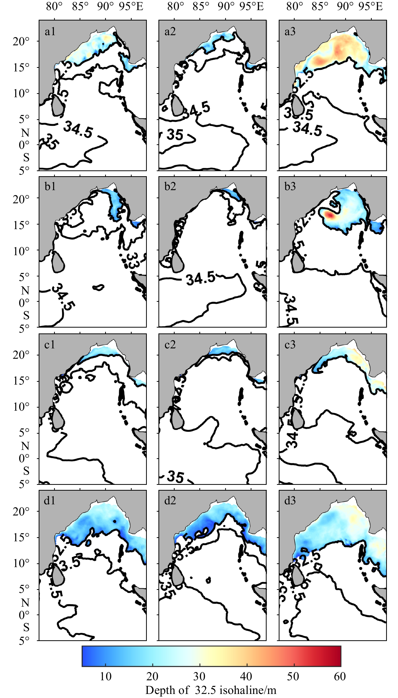
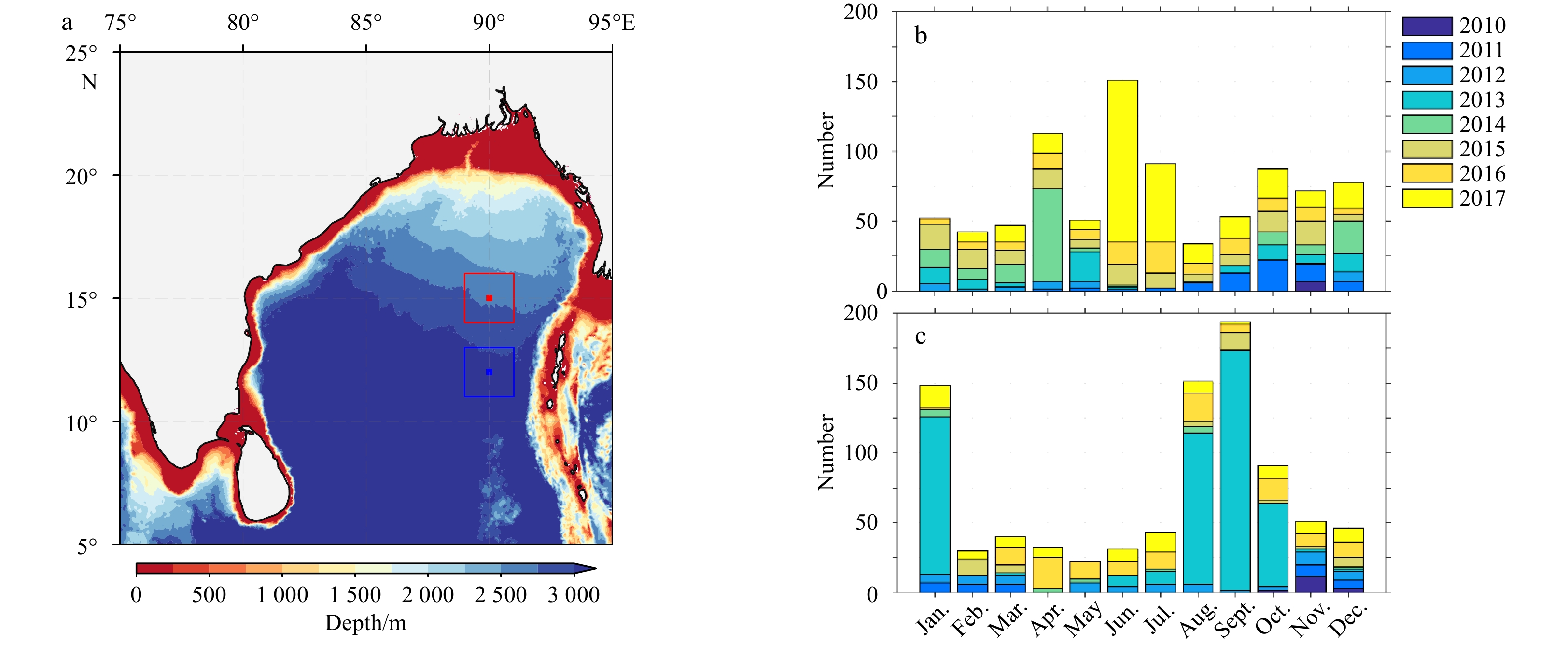
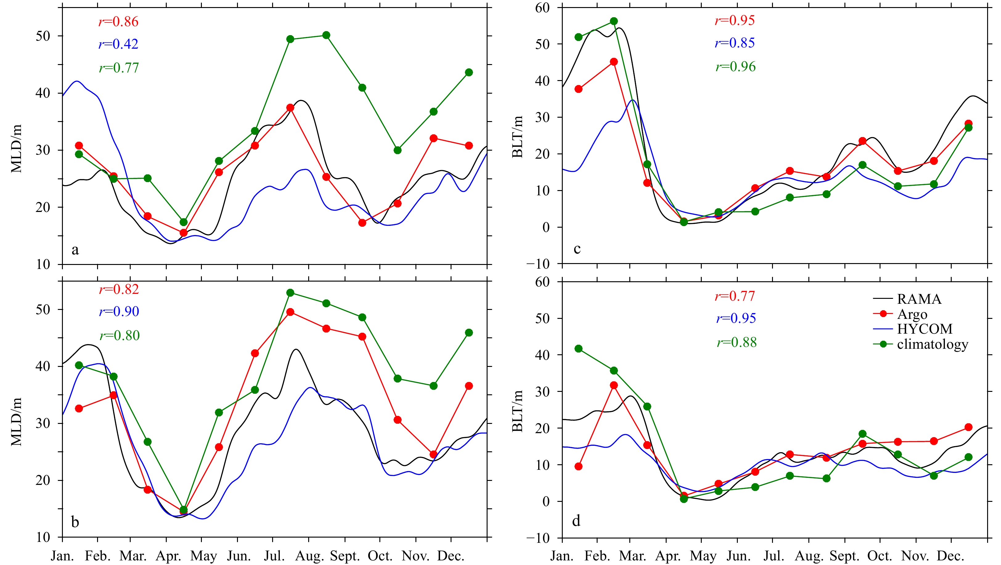
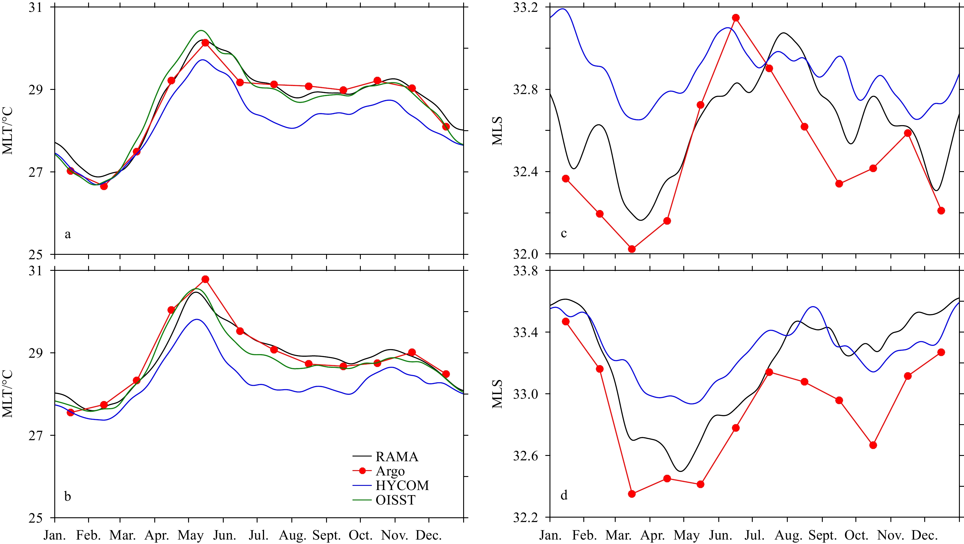
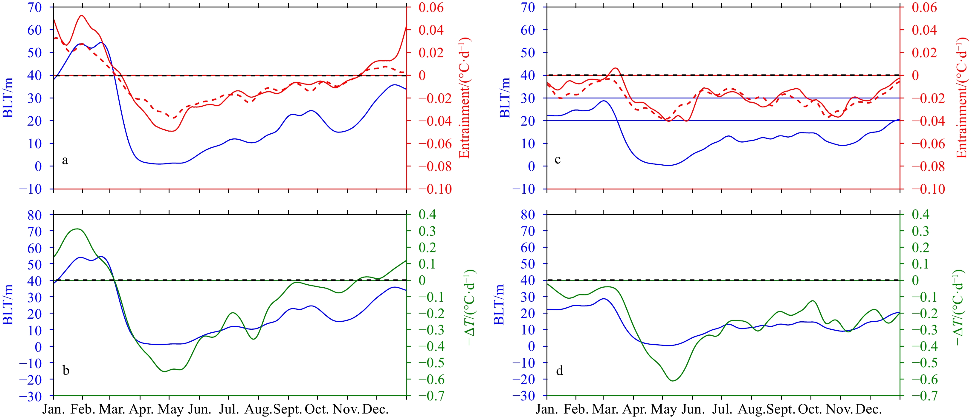
Time series measurements (2010–2017) from the Research Moored Array for African–Asian–Australian Monsoon Analysis and Prediction (RAMA) moorings at 15°N, 90°E and 12°N, 90°E are used to investigate the effect of the seasonal barrier layer (BL) on the mixed-layer heat budget in the Bay of Bengal (BoB). The mixed-layer temperature tendency (∂T/∂t) is primarily controlled by the net surface heat flux that remains in the mixed layer (\begin{document}${Q}^{{'}}$\end{document}) from March to October, while both \begin{document}${Q}^{{'}}$\end{document} and the vertical heat flux at the base of the mixed layer (\begin{document}$ {Q}_{h} $\end{document}), estimated as the residual of the mixed-layer heat budget, dominate during winter (November–February). An inverse relation is observed between the BL thickness and the mixed-layer temperature (\begin{document}$ \mathrm{M}\mathrm{L}\mathrm{T} $\end{document}). Based on the estimations at the moorings, it is suggested that when the BL thickness is ≥25 m, it exerts a considerable influence on ∂T/∂t through the modulation of \begin{document}$ {Q}_{h} $\end{document} (warming) in the BoB. The cooling associated with \begin{document}$ {Q}_{h} $\end{document} is strongest when the BL thickness is ≤10 m with the \begin{document}$ \mathrm{M}\mathrm{L}\mathrm{T} $\end{document} exceeding 29°C, while the contribution from \begin{document}$ {Q}_{h} $\end{document} remains nearly zero when the BL thickness varies between 10 m and 25 m. Temperature inversion is evident in the BoB during winter when the BL thickness remains ≥25 m with an average MLT<28.5°C. Furthermore, \begin{document}$ {Q}_{h} $\end{document} follows the seasonal cycle of the BL at these RAMA mooring locations, with r>0.72 at the 95% significance level.
Temporal and spatial changes of the basal channel of the Getz Ice Shelf in Antarctica derived from multi-source data
Zemin Wang, Mingliang Liu, Baojun Zhang, Xiangyu Song, Jiachun An
2022, 41(9): 50-59. doi: 10.1007/s13131-022-1989-1
Abstract:
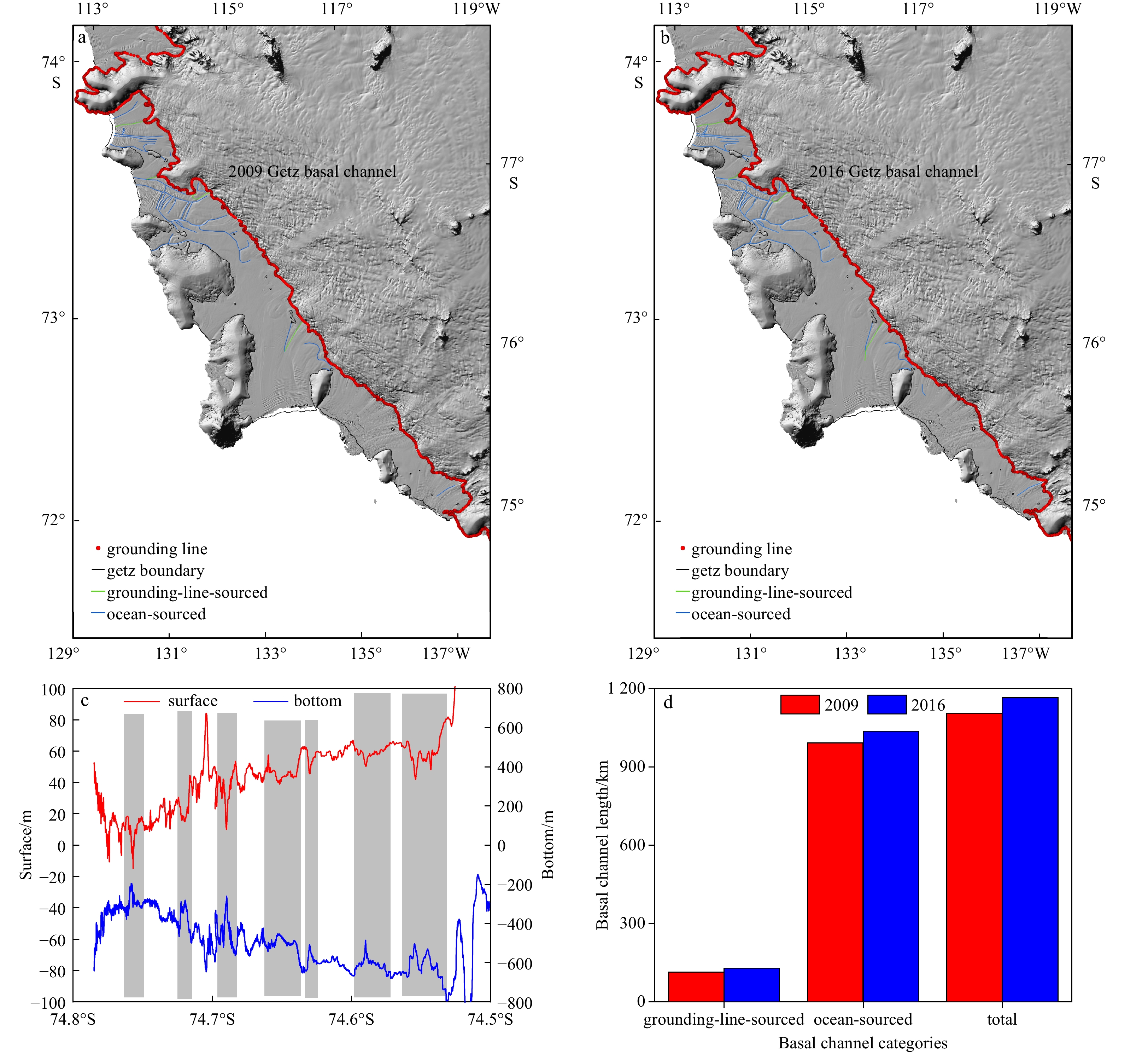
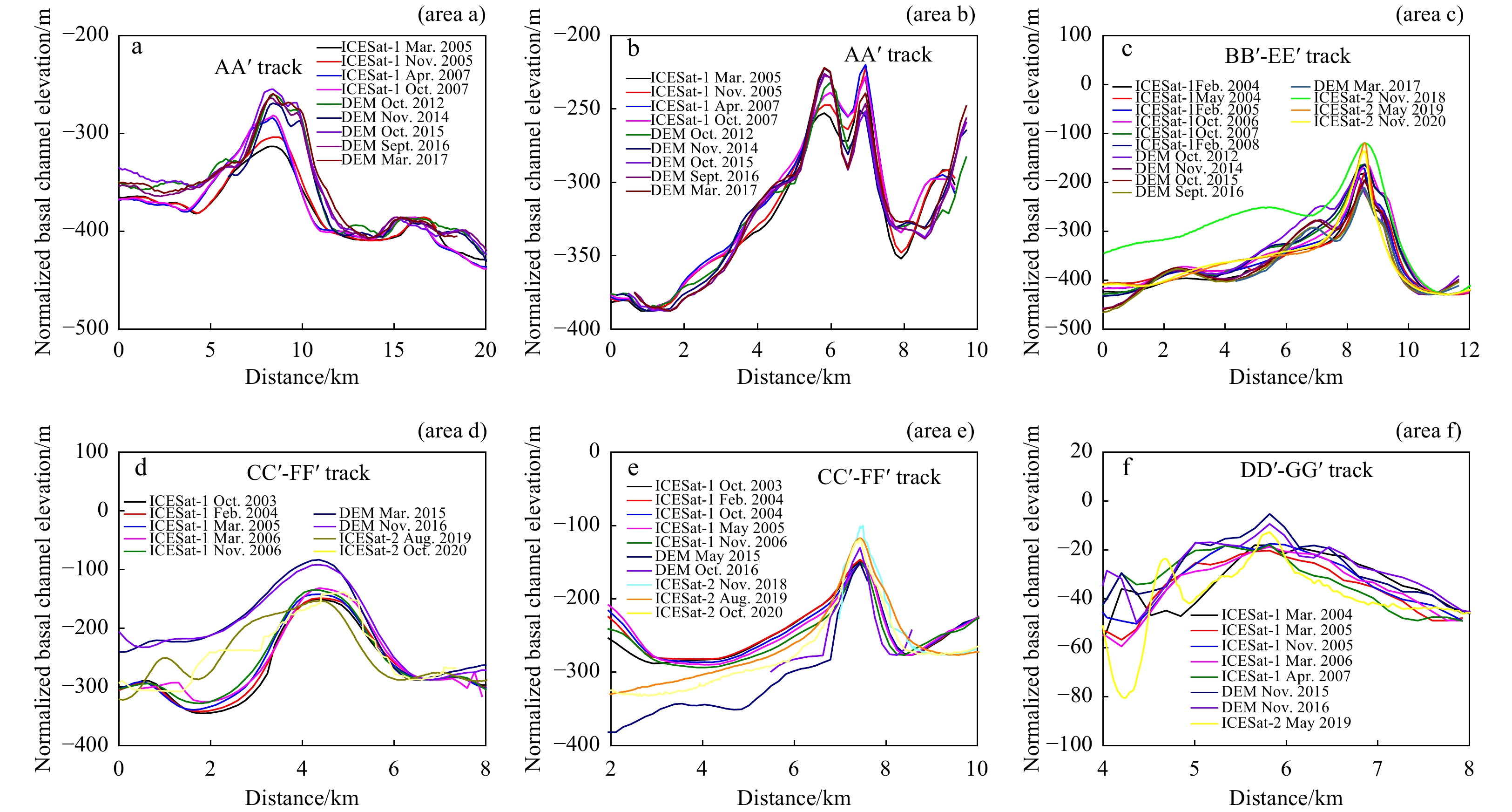
Basal melting is an important factor affecting the stability of the ice shelf. The basal channel is formed from uneven melting, which also has an important impact on the stability of the ice shelf. Therefore, it has important scientific value to study the basal channel changes. This study combined datasets of Mosaics of Antarctica, Reference Elevation Model of Antarctica (REMA) and Operation IceBridge to study the temporal and spatial changes of basal channels at the Getz Ice Shelf in Antarctica. The relationships between the cross-sectional area and width of basal channel and those of its corresponding surface depression were statistically analyzed. Then, the changes of the basal channels of Getz Ice Shelf were derived from the ICESat observations and REMA digital elevation models (DEMs). After a detailed analysis of the factors affecting the basal channel changes, we found that the basal channels of Getz Ice Shelf were mainly concentrated in the eastern of the ice shelf, and most of them belonged to the ocean-sourced basal channel. From 2009 to 2016, the total length of the basal channel has increased by approximately 60 km. Affected by the warm Circumpolar Deep Water (CDW), significant changes in the basal channel occurred in the middle reaches of the Getz Ice Shelf. The change of the basal channels at the edge of the Getz Ice Shelf is significantly weaker than that in its middle and upper reaches. Especially in 2005–2012, the eastward wind on the ocean wind field and the westward wind around the continental shelf caused the invasion and upwelling of CDW. Meanwhile, the continuous warming of deep seawater also caused the deepening of the basal channel. During from 2012 to 2020, the fluctuations of the basal channels seem to be caused by the changes in temperature of CDW.
An application of the A-4DEnVar to coupled parameter optimization
Yantian Gong, Kangzhuang Liang, Xinrong Wu, Qi Shao, Wei Li, Siyuan Liu, Guijun Han, Hanyu Liu
2022, 41(9): 60-70. doi: 10.1007/s13131-022-1997-1
Abstract:
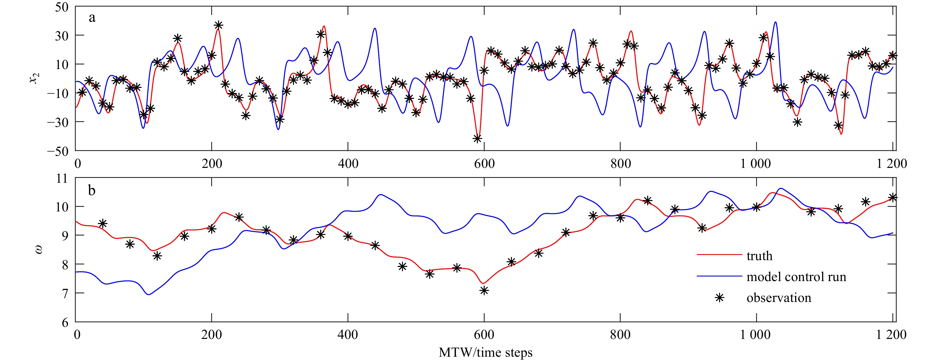
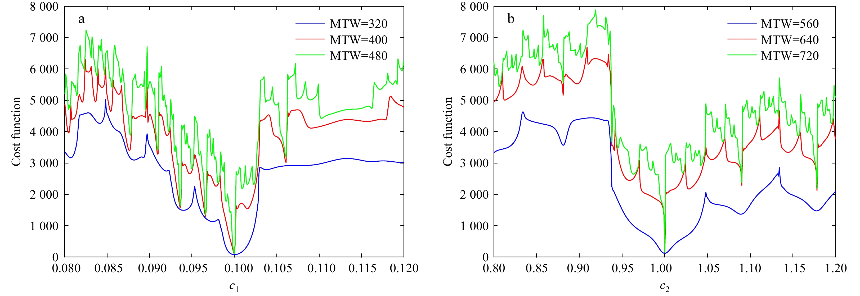
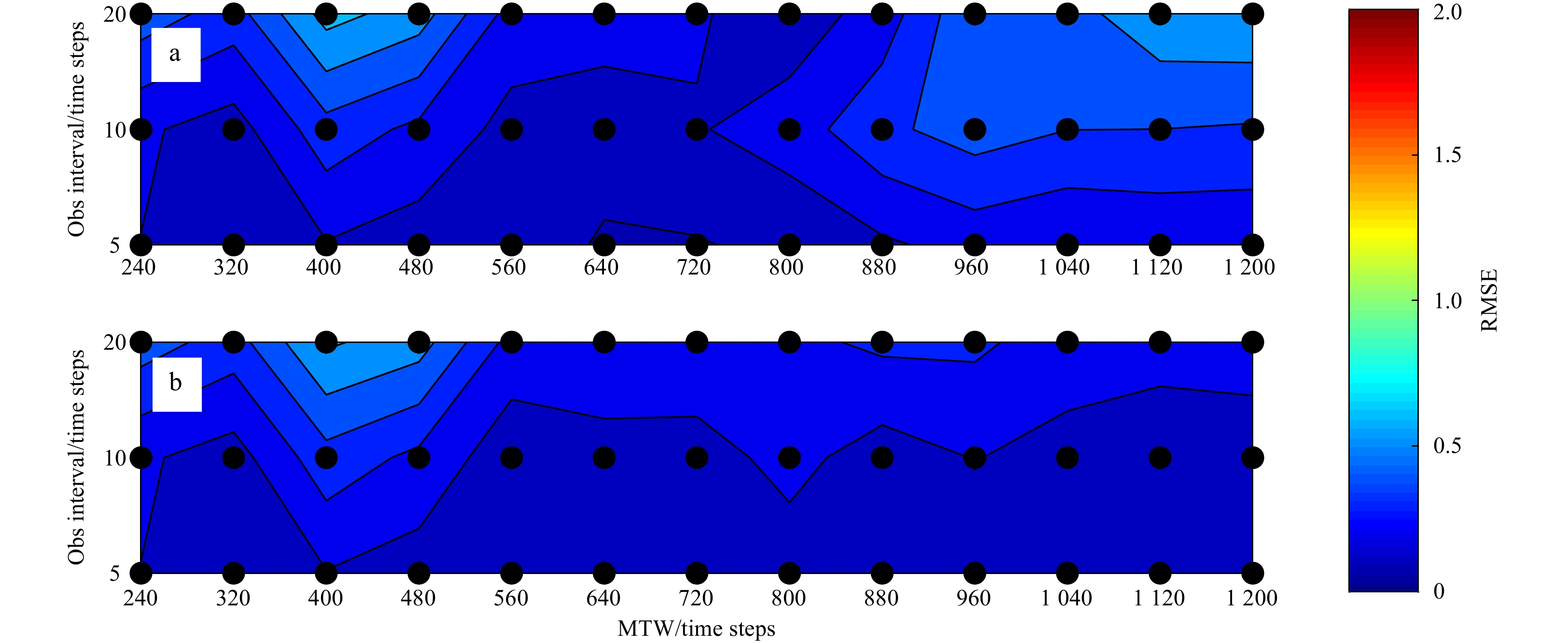
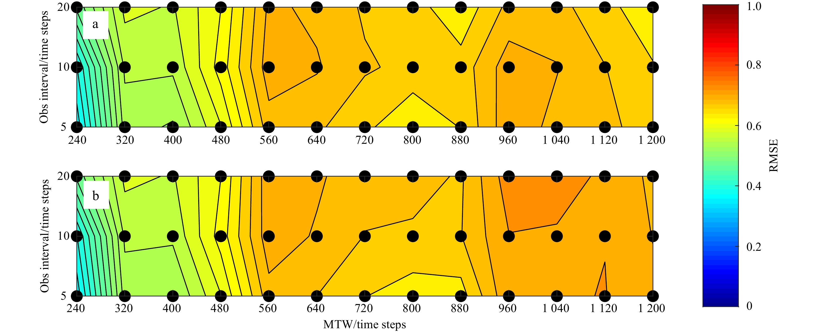
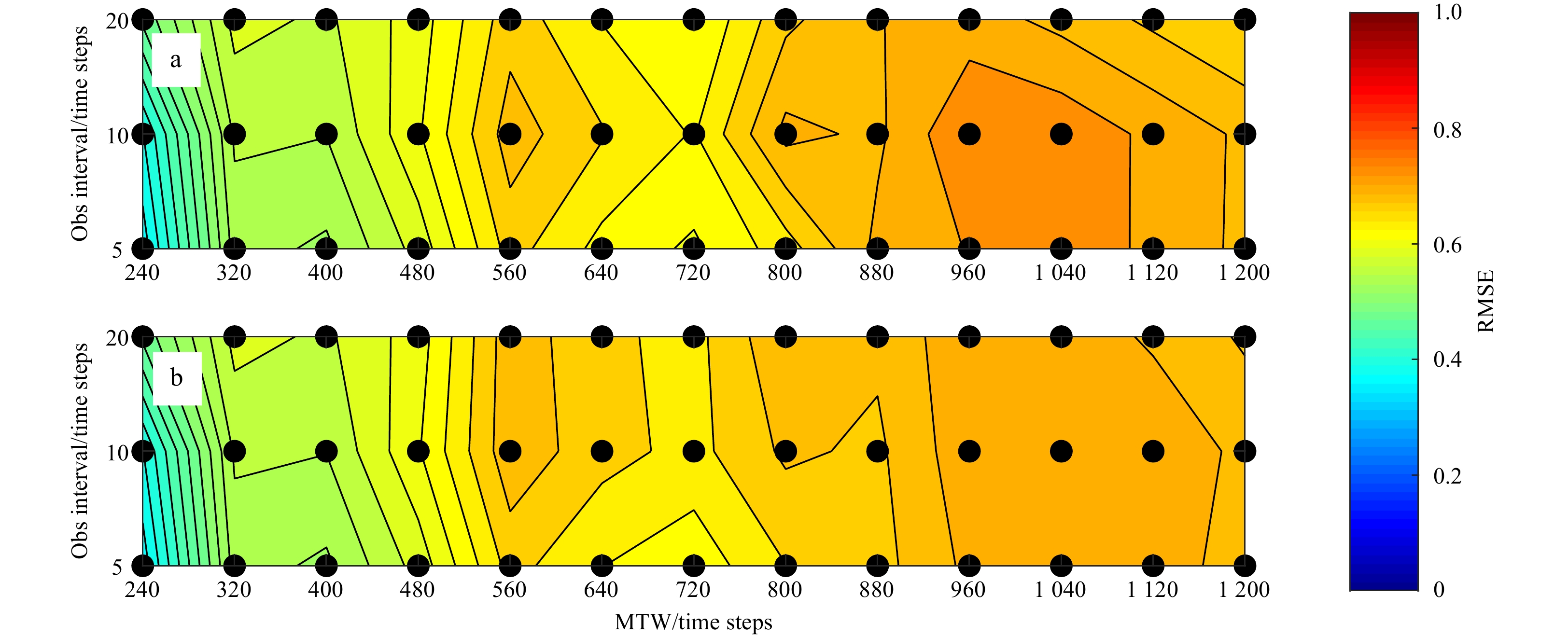
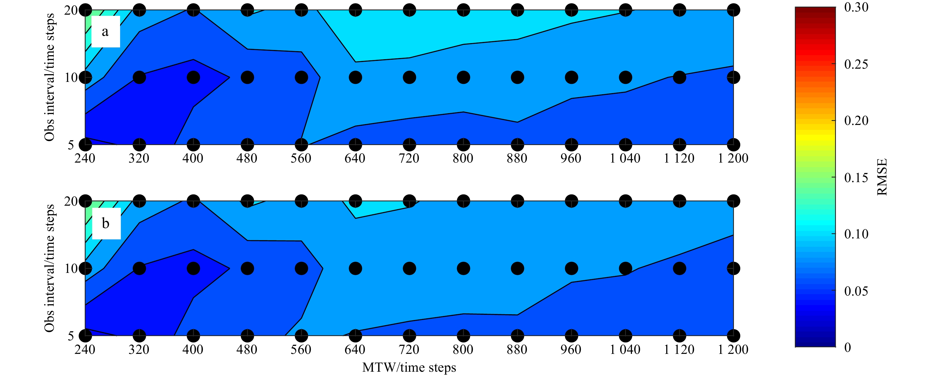
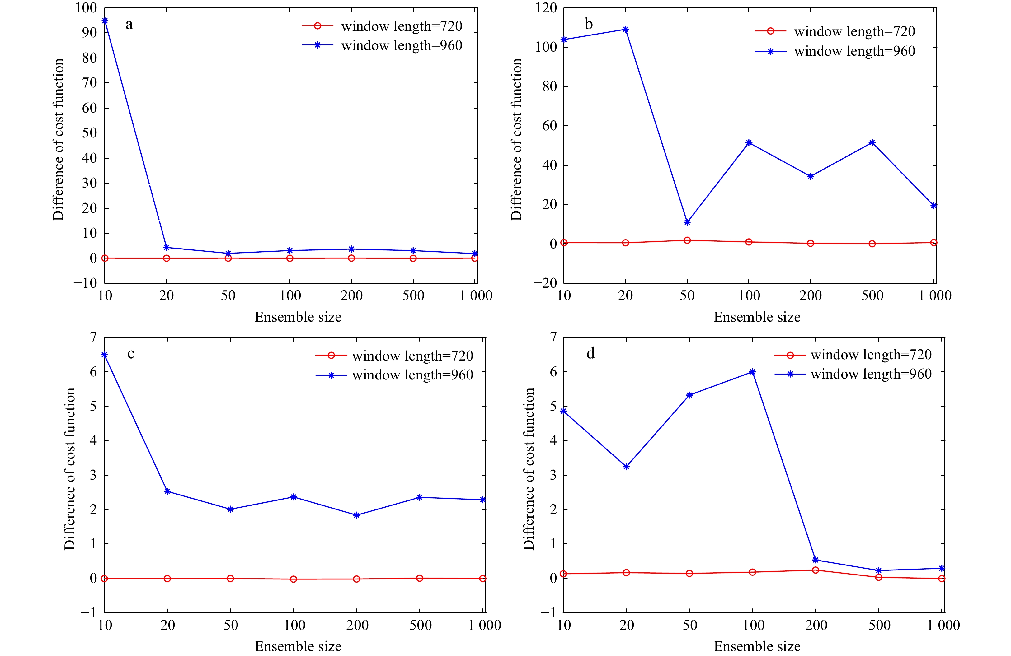
In variational methods, coupled parameter optimization (CPO) often needs a long minimization time window (MTW) to fully incorporate observational information, but the optimal MTW somehow depends on the model nonlinearity. The analytical four-dimensional ensemble-variational (A-4DEnVar) considers model nonlinearity well and avoids adjoint model. It can theoretically be applied to CPO. To verify the feasibility and the ability of the A-4DEnVar in CPO, “twin” experiments based on A-4DEnVar CPO are conducted for the first time with the comparison of four-dimensional variational (4D-Var). Two algorithms use the same background error covariance matrix and optimization algorithm to control variates. The experiments are based on a simple coupled ocean-atmosphere model, in which the atmospheric part is the highly nonlinear Lorenz-63 model, and the oceanic part is a slab ocean model. The results show that both A-4DEnVar and 4D-Var can effectively reduce the error of state variables through CPO. Besides, two methods produce almost the same results in most cases when the MTW is less than 560 time steps. The results are similar when the MTW is larger than 560 time steps and less than 880 time steps. The largest MTW of 4D-Var and A-4DEnVar are 1 200 time steps. Moreover, A-4DEnVar is not sensitive to ensemble size when the MTW is less than 720 time steps. A-4DEnVar obtains satisfactory results in the case of highly nonlinear model and long MTW, suggesting that it has the potential to be widely applied to realistic CPO.
A fast inversion method for ocean parameters based on dispersion curves with a single hydrophone
Xiaoman Li, Biao Wang, Xuejie Bi, Hong Wu
2022, 41(9): 71-85. doi: 10.1007/s13131-022-1999-z
Abstract:
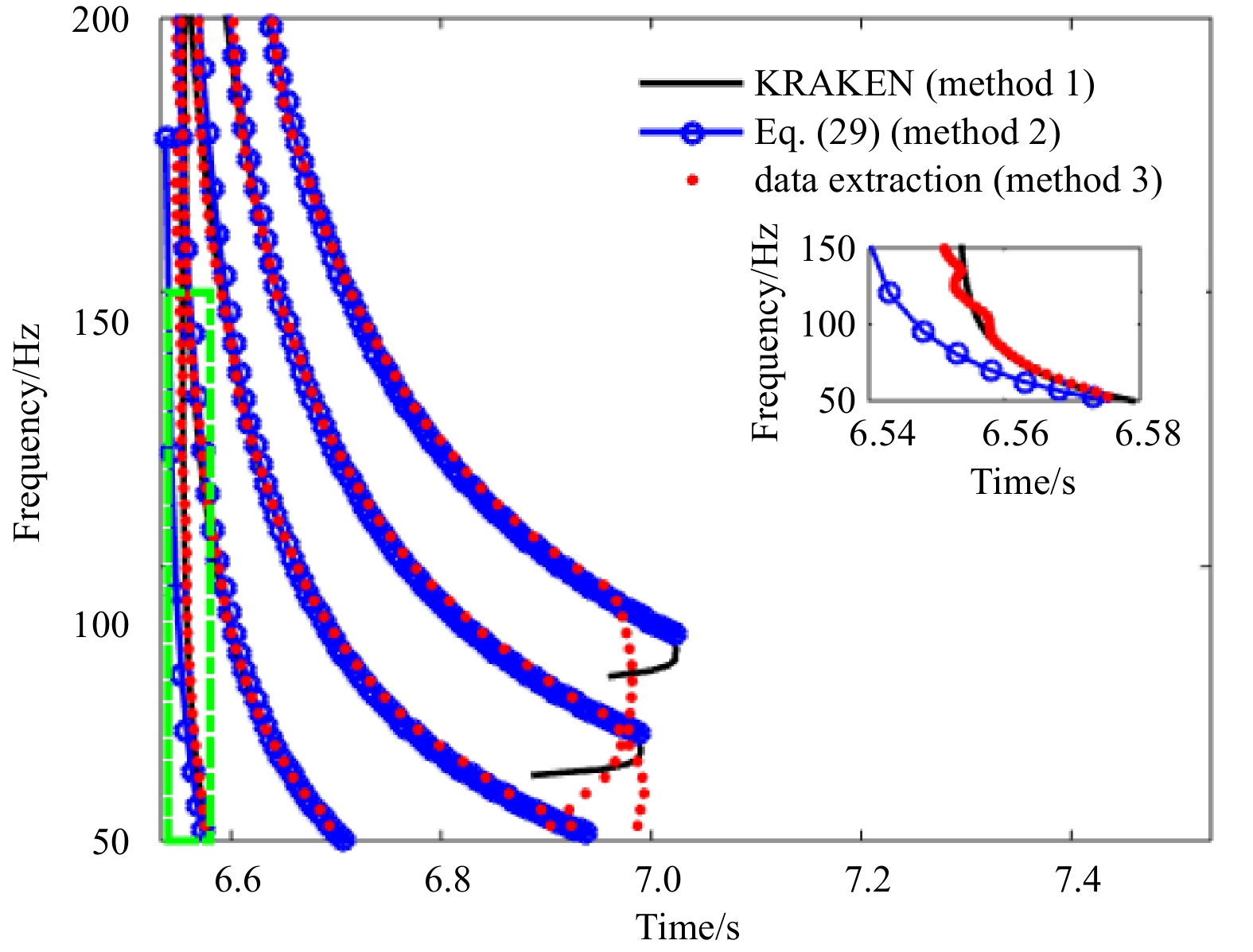
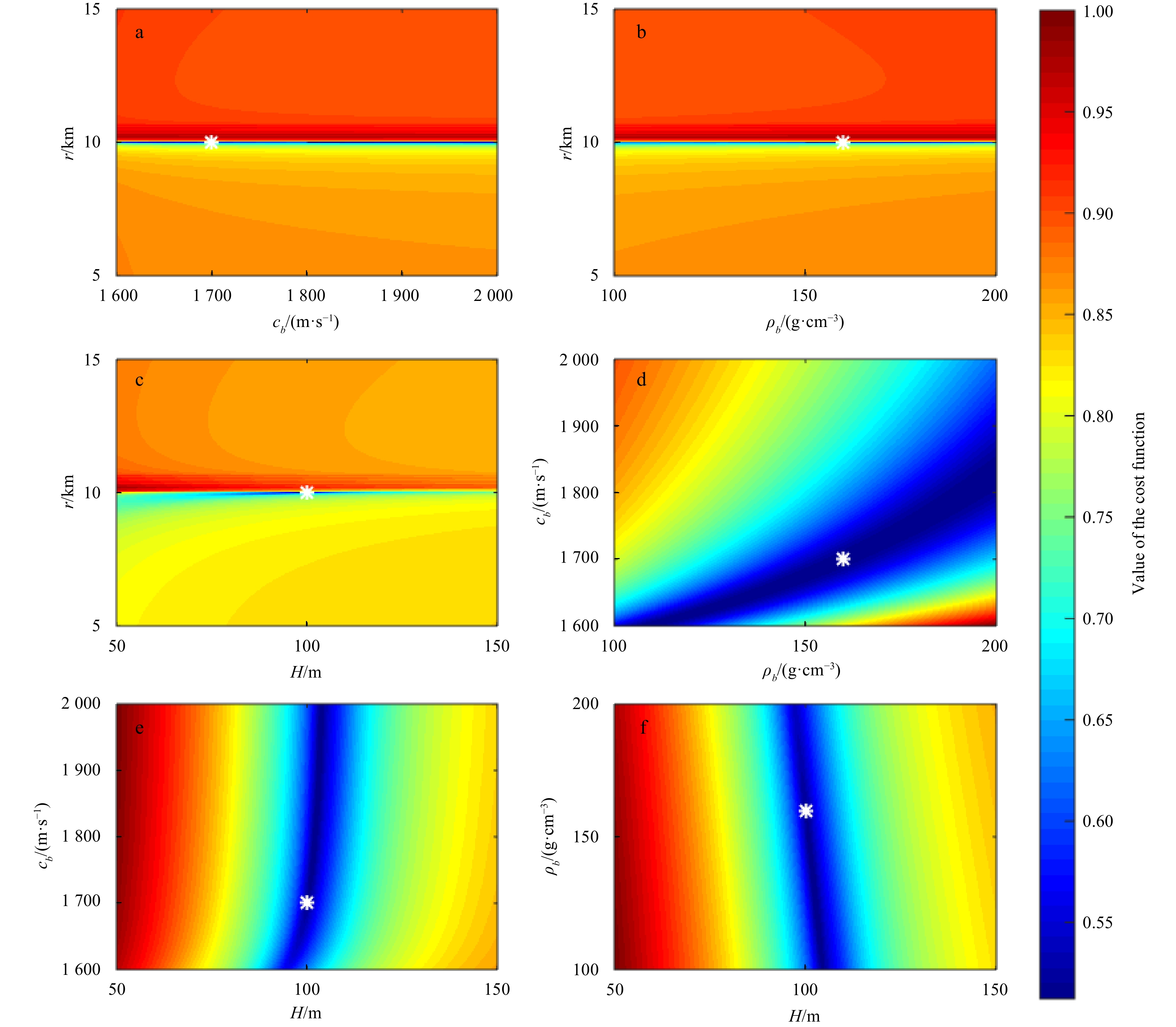
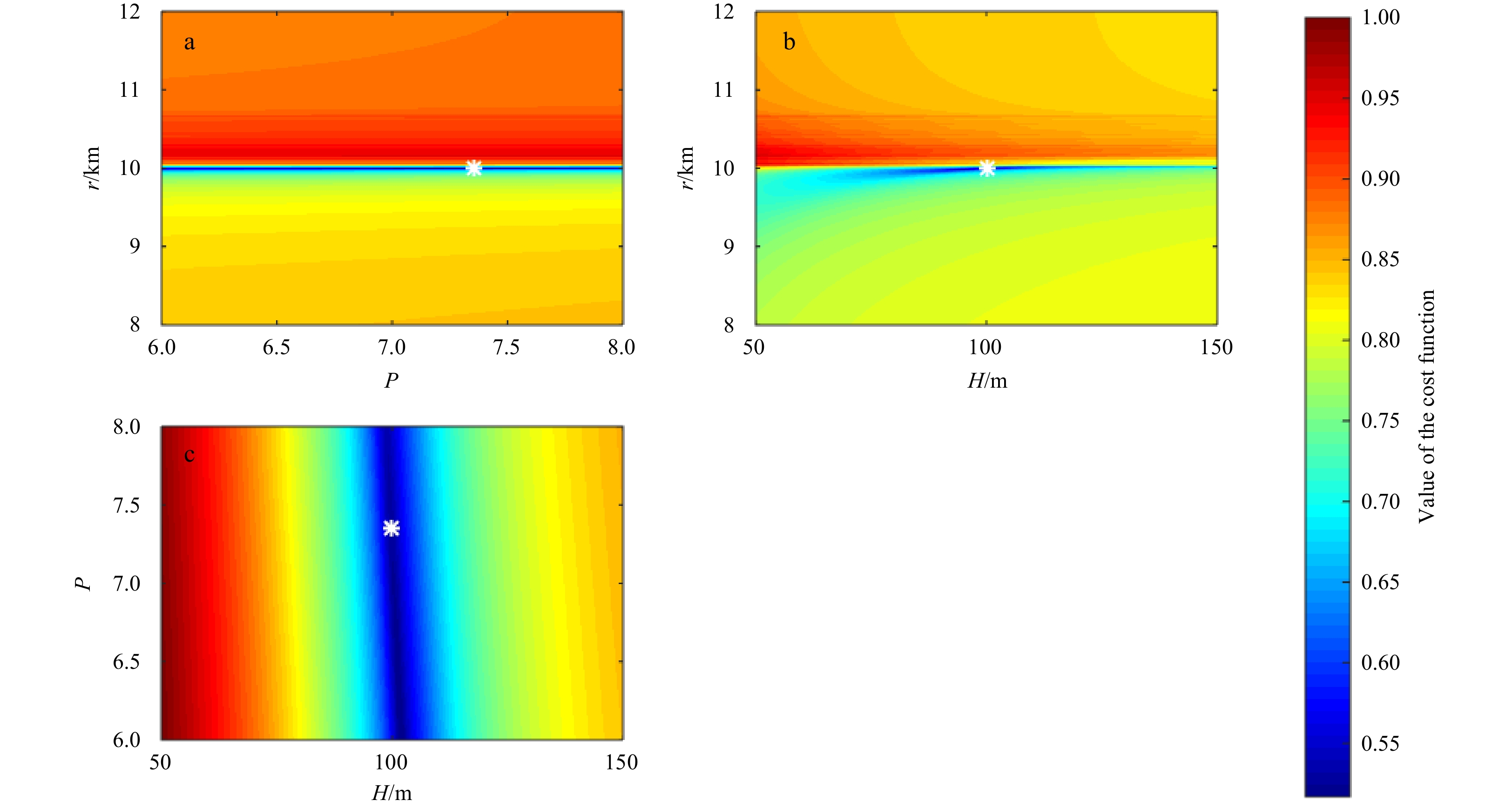
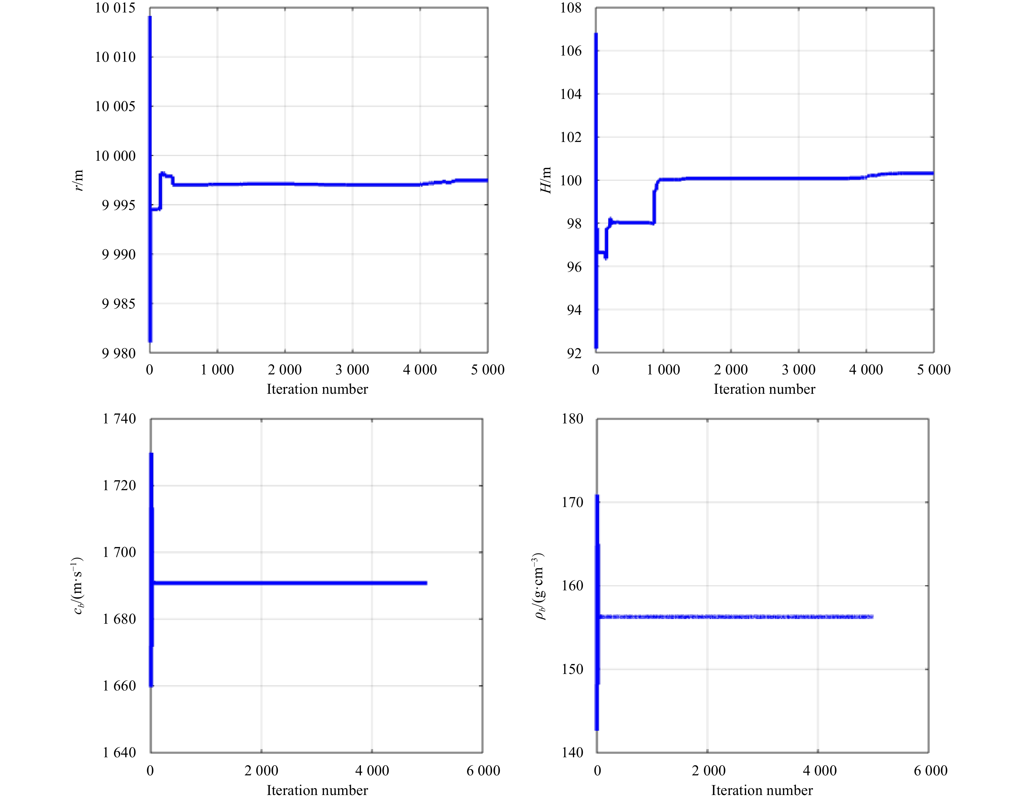
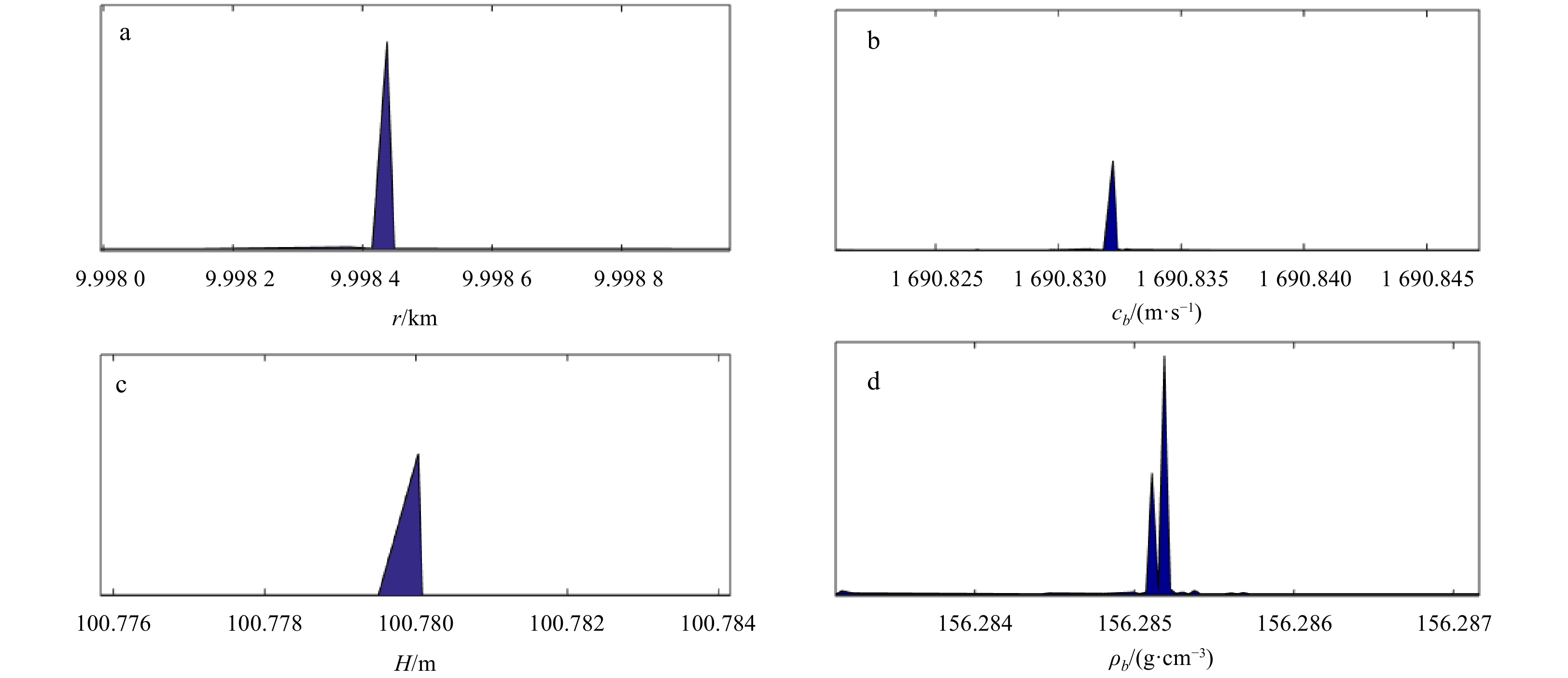
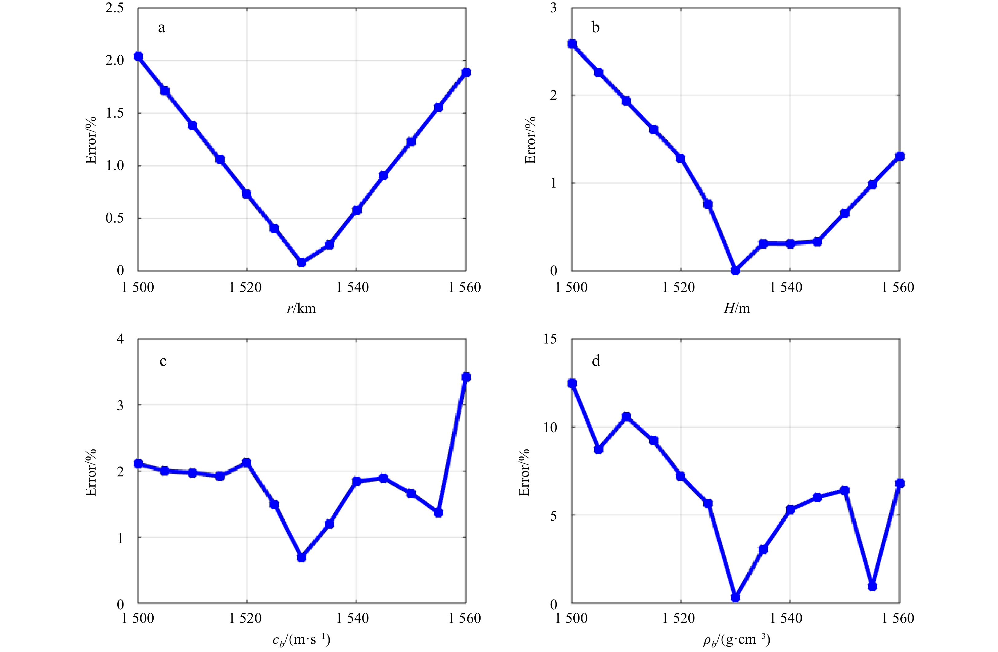
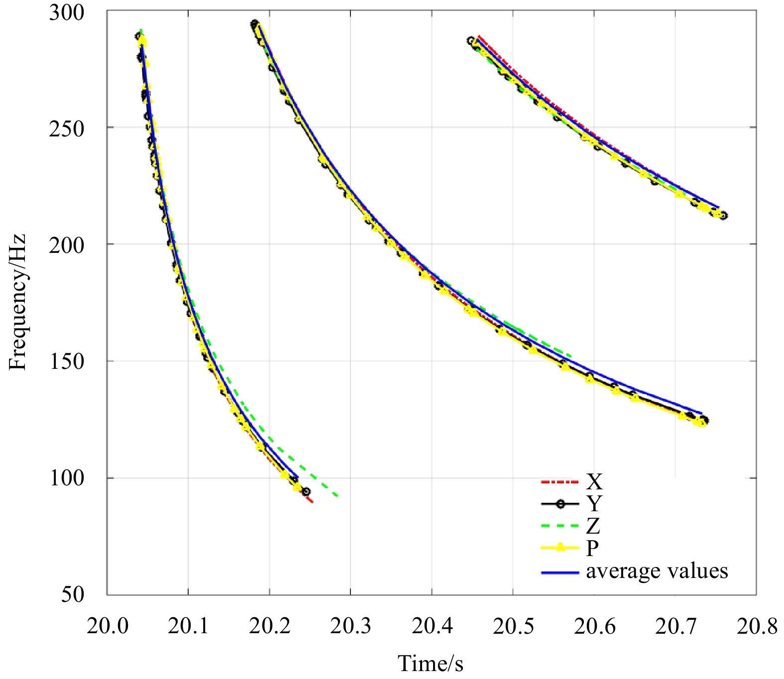
The dispersion characteristics of shallow water can be described by the dispersion curves, which contain substantial ocean parameter information. A fast ocean parameter inversion method based on dispersion curves with a single hydrophone is presented in this paper. The method is achieved through Bayesian theory. Several sets of dispersion curves extracted from measured data are used as the input function. The inversion is performed by matching a replica calculated with a dispersion formula. The bottom characteristics can be described by the bottom reflection phase shift parameter P. The propagation range and the depth can be inverted quickly when the seabed parameters are represented by on parameter P. The inversion results improve the inversion efficiency of the seabed parameters. Consequently, the inversion efficiency and accuracy are improved while the number of inversion parameters is decreased and the computational speed of replica is increased. The inversion results have lower error than the reference values, and the dispersion curves calculated with inversion parameters are also in good agreement with extracted curves from measured data; thus, the effectiveness of the inversion method is demonstrated.
Articles$Marine Geology
Distribution characteristics of delta reservoirs reshaped by bottom currents: A case study from the second member of the Yinggehai Formation in the DF1-1 gas field, Yinggehai Basin, South China Sea
Shuo Chen, Renhai Pu, Huiqiong Li, Hongjun Qu, Tianyu Ji, Siyu Su, Yunwen Guan, Hui Zhang
2022, 41(9): 86-106. doi: 10.1007/s13131-022-1992-6
Abstract:
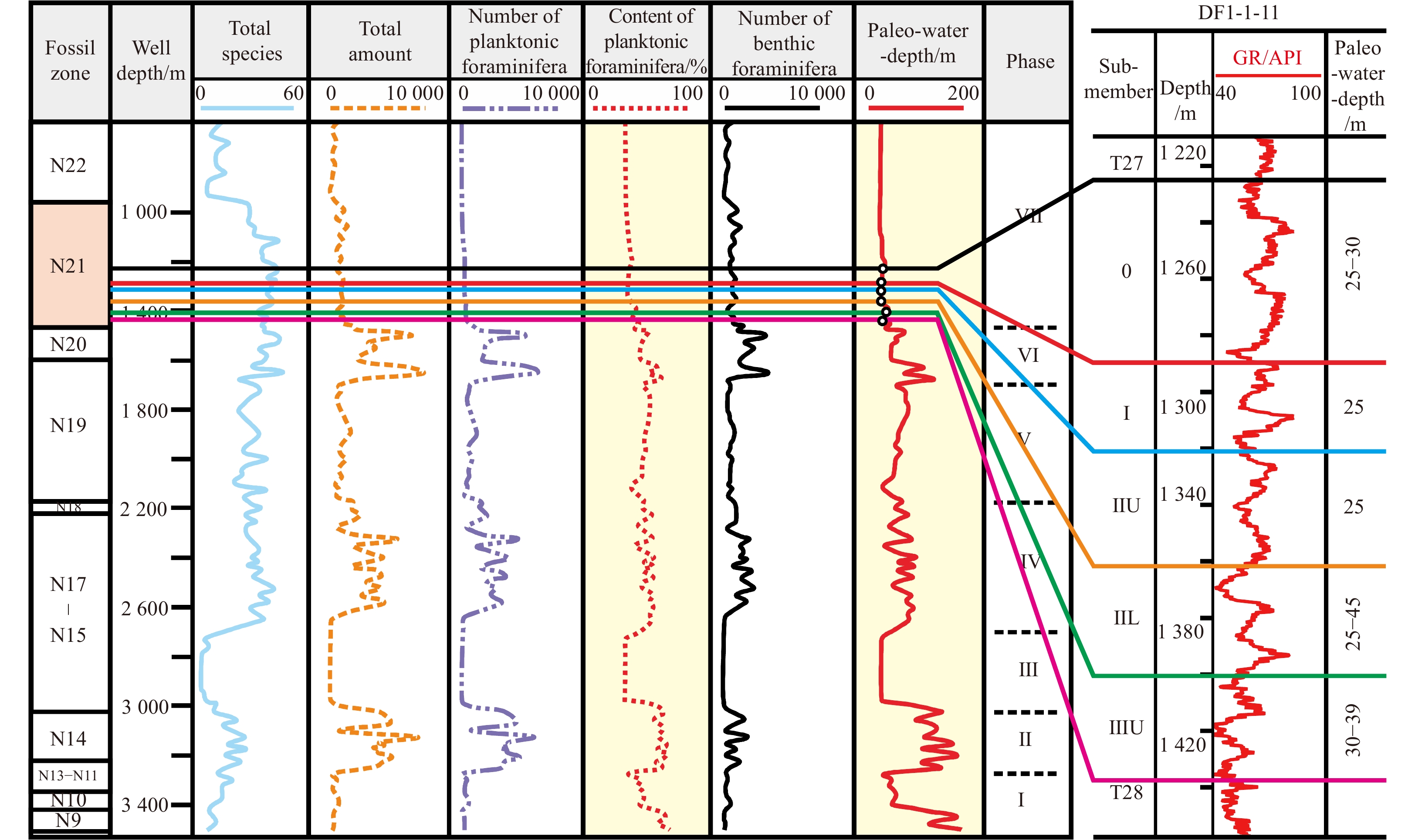
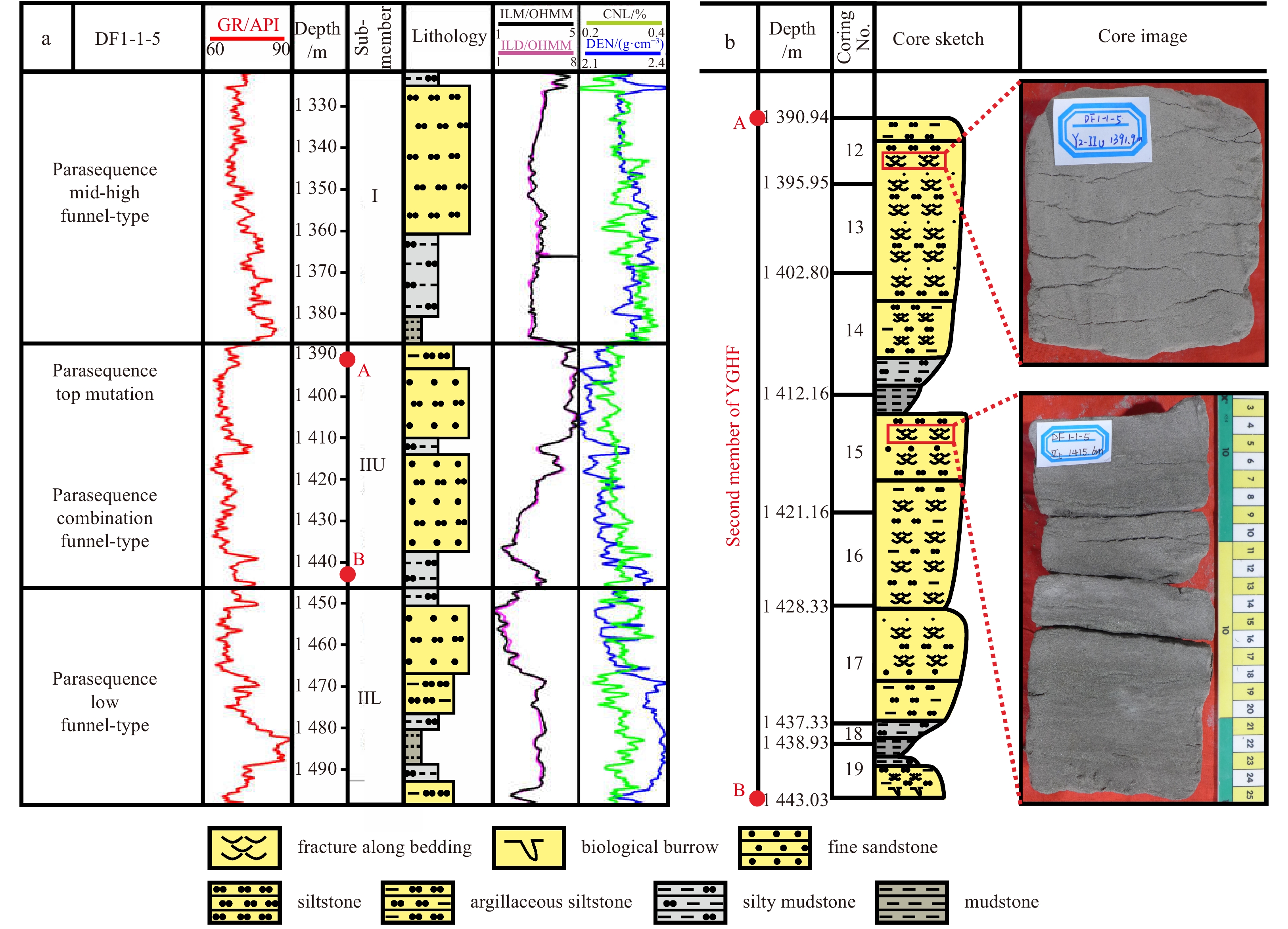
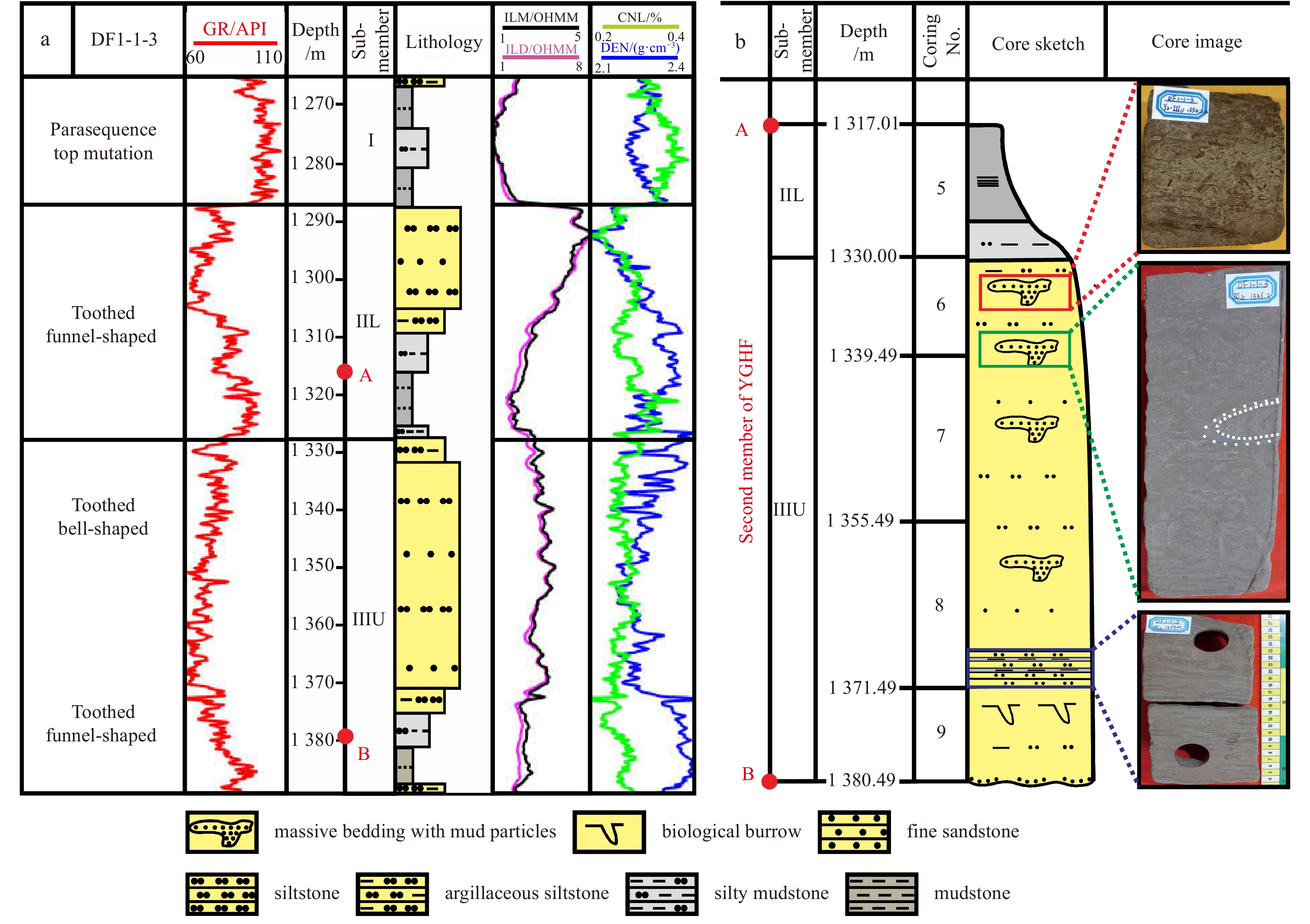
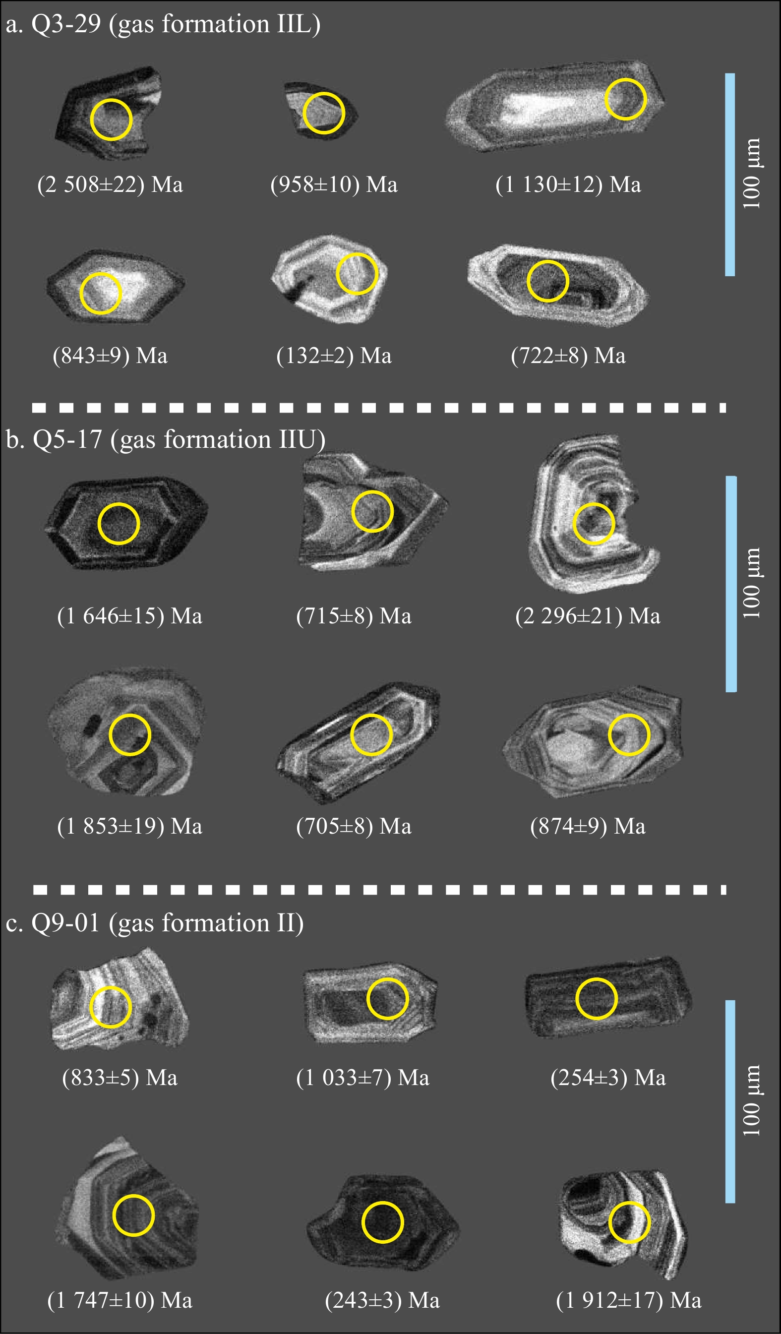
The Dongfang1-1 gas field (DF1-1) in the Yinggehai Basin is currently the largest offshore self-developed gas field in China and is rich in oil and gas resources. The second member of the Pliocene Yinggehai Formation (YGHF) is the main gas-producing formation and is composed of various sedimentary types; however, a clear understanding of the sedimentary types and development patterns is lacking. Here, typical lithofacies, logging facies and seismic facies types and characteristics of the YGHF are identified based on high-precision 3D seismic data combined with drilling, logging, analysis and testing data. Based on 3D seismic interpretation and attribute analysis, the origin of high-amplitude reflections is clarified, and the main types and evolution characteristics of sedimentary facies are identified. Taking gas formation upper II (IIU) as an example, the plane distribution of the delta front and bottom current channel is determined; finally, a comprehensive sedimentary model of the YGHF second member is established. This second member is a shallowly buried “bright spot” gas reservoir with weak compaction. The velocity of sandstone is slightly lower than that of mudstone, and the reflection has medium amplitude when there is no gas. The velocity of sandstone decreases considerably after gas accumulation, resulting in an increase in the wave impedance difference and high-amplitude (bright spot) reflection between sandstone and mudstone; the range of high amplitudes is consistent with that of gas-bearing traps. The distribution of gas reservoirs is obviously controlled by dome-shaped diapir structural traps, and diapir faults are channels through which natural gas from underlying Miocene source rocks can enter traps. The study area is a delta front deposit developed on a shallow sea shelf. The lithologies of the reservoir are mainly composed of very fine sand and coarse silt, and a variety of sedimentary structural types reflect a shallow sea delta environment; upward thickening funnel type, strong toothed bell type and toothed funnel type logging facies are developed. In total, 4 stages of delta front sand bodies (corresponding to progradational reflection seismic facies) derived from the Red River and Blue River in Vietnam have developed in the second member of the YGHF; these sand bodies are dated to 1.5 Ma and correspond to four gas formations. During sedimentation, many bottom current channels (corresponding to channel fill seismic facies) formed, which interacted with the superposed progradational reflections. When the provenance supply was strong in the northwest, the area was dominated by a large set of delta front deposits. In the period of relative sea level rise, surface bottom currents parallel to the coastline were dominant, and undercutting erosion was obvious, forming multistage superimposed erosion troughs. Three large bottom current channels that developed in the late sedimentary period of gas formation IIU are the most typical.
Mounded seismic units in the modern canyon system in the Shenhu area, northern South China Sea: Sediment deformation, depositional structures or the mixed system?
Xishuang Li, Chengyi Zhang, Baohua Liu, Lejun Liu
2022, 41(9): 107-116. doi: 10.1007/s13131-022-2002-8
Abstract:
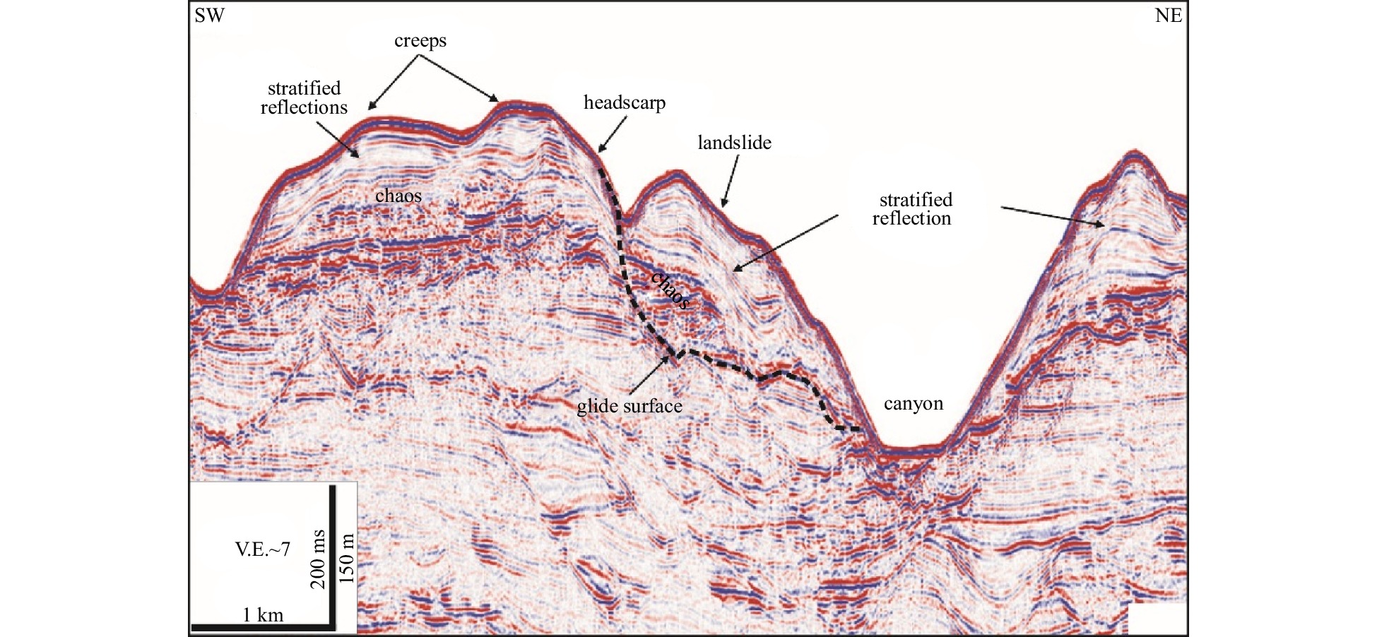
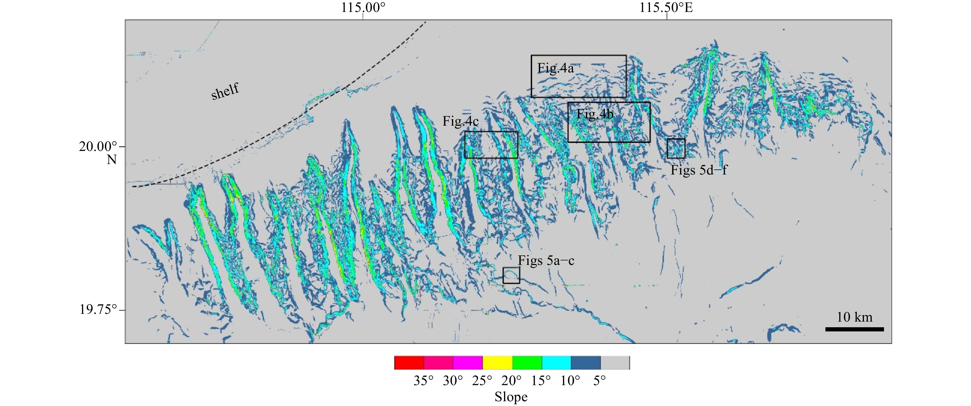
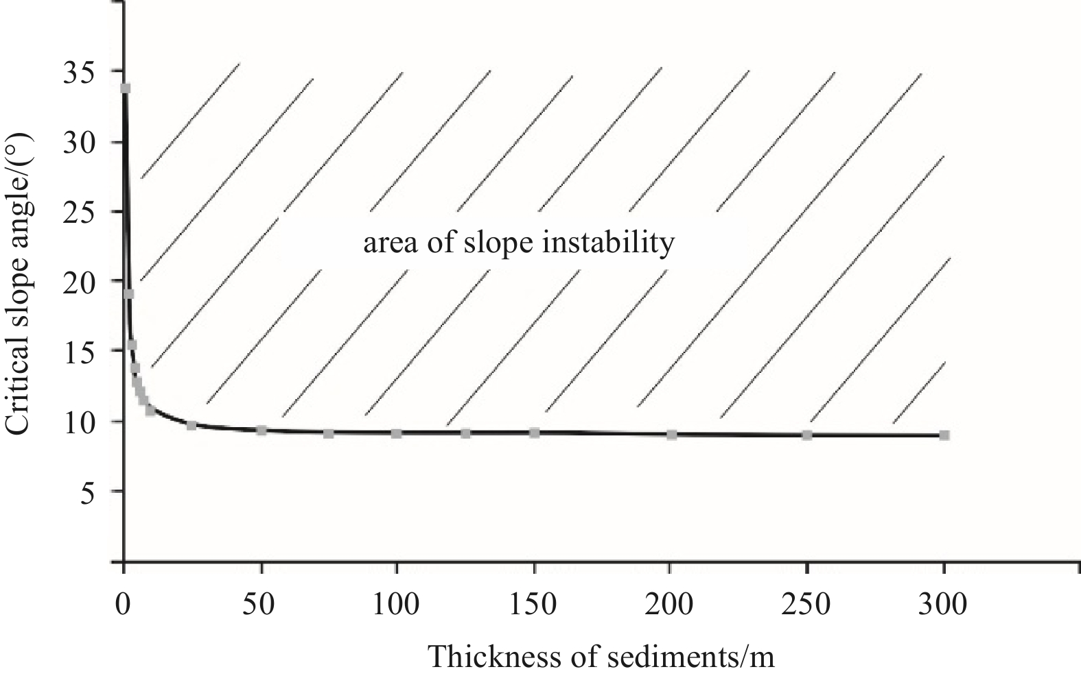
The canyon system, including 17 small slope-confined canyons in the Shenhu area, northern South China Sea, is significantly characterized by mounded or undulating features on the canyon flanks and canyon heads. However, the mechanism underlying the formation of these features has yet to be elucidated. In previous studies, most of them were interpreted as sediment deformation on the exploration seismic profiles. In this paper, we collected high-resolution bathymetric data, chirp profiles and geotechnical test data to investigate their detailed morphology, internal structures, and origin. The bathymetric data indicated that most mounded seismic units have smooth seafloors and are separated by grooves or depressions. The distance between two adjacent mounded units is only hundreds of meters. On chirp profiles, mounded seismic units usually exhibit chaotic reflections and wavy reflections, of which the crests migrate upslope. The slope stability analysis results revealed that the critical angle of the soil layers in the study area tends to be 9°, indicating that most mounded seismic units on the canyon flanks and heads are stable at present. The terrain characteristics and seismic configurations combined with the slope stability analysis results indicated that most mounded seismic units are not sediment deformation but depositional structures or mixed systems composed of deformation and depositional structures.
Control of the stress field on shallow seafloor hydrothermal paths: A case study of the TAG hydrothermal field
Mingxu Wang, Chunhui Tao, Chao Lei, Hanchuang Wang, Ming Chen
2022, 41(9): 117-126. doi: 10.1007/s13131-022-2003-7
Abstract:
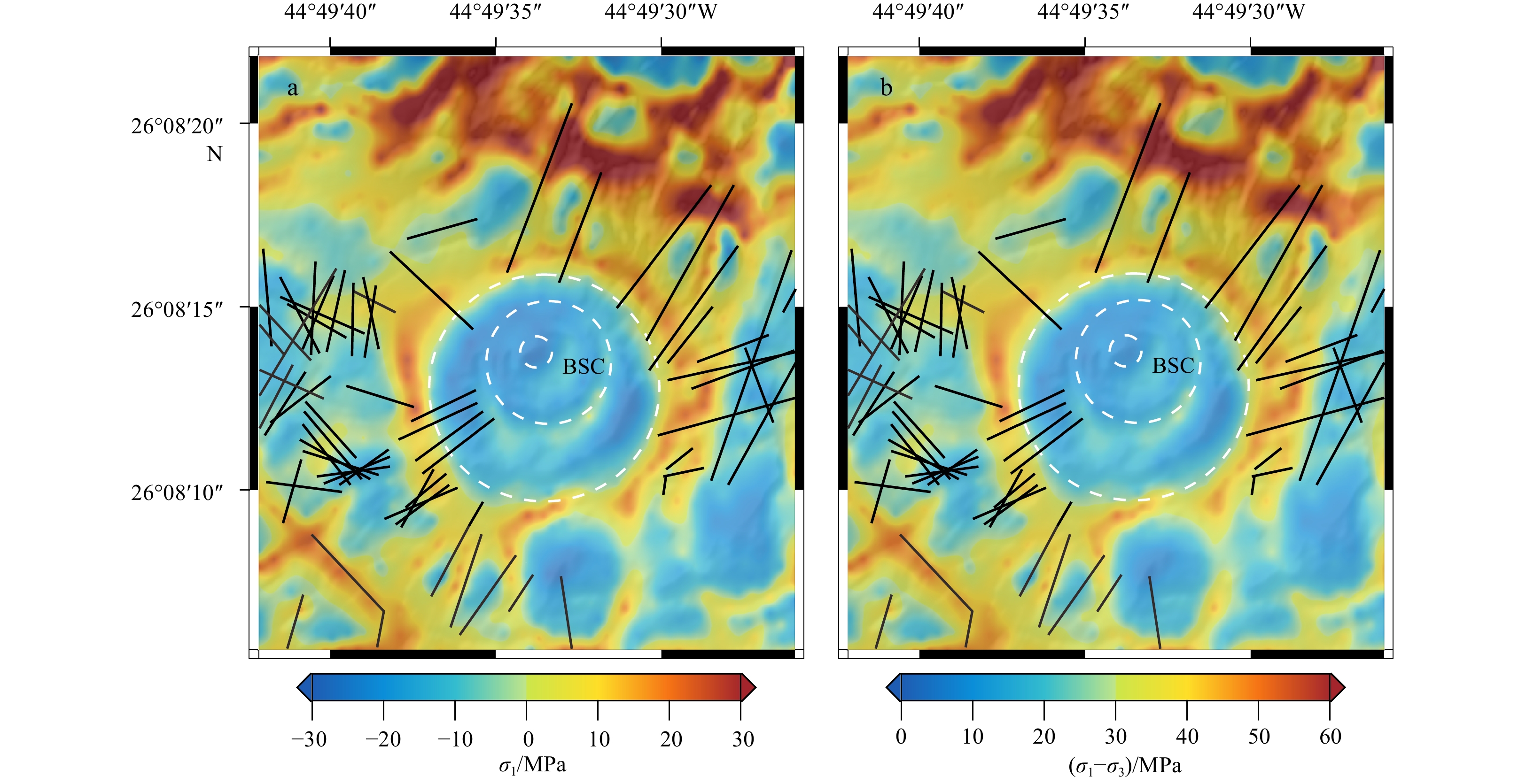
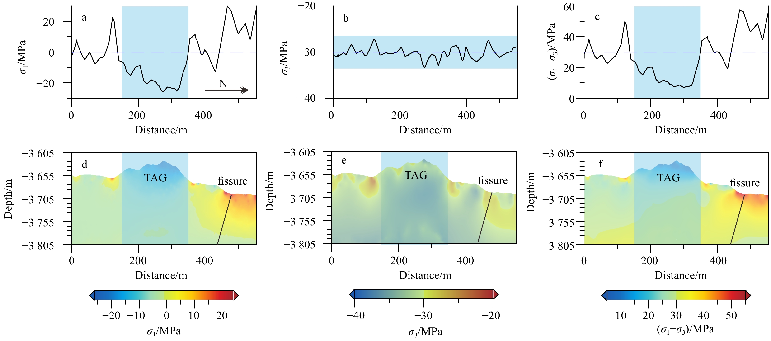
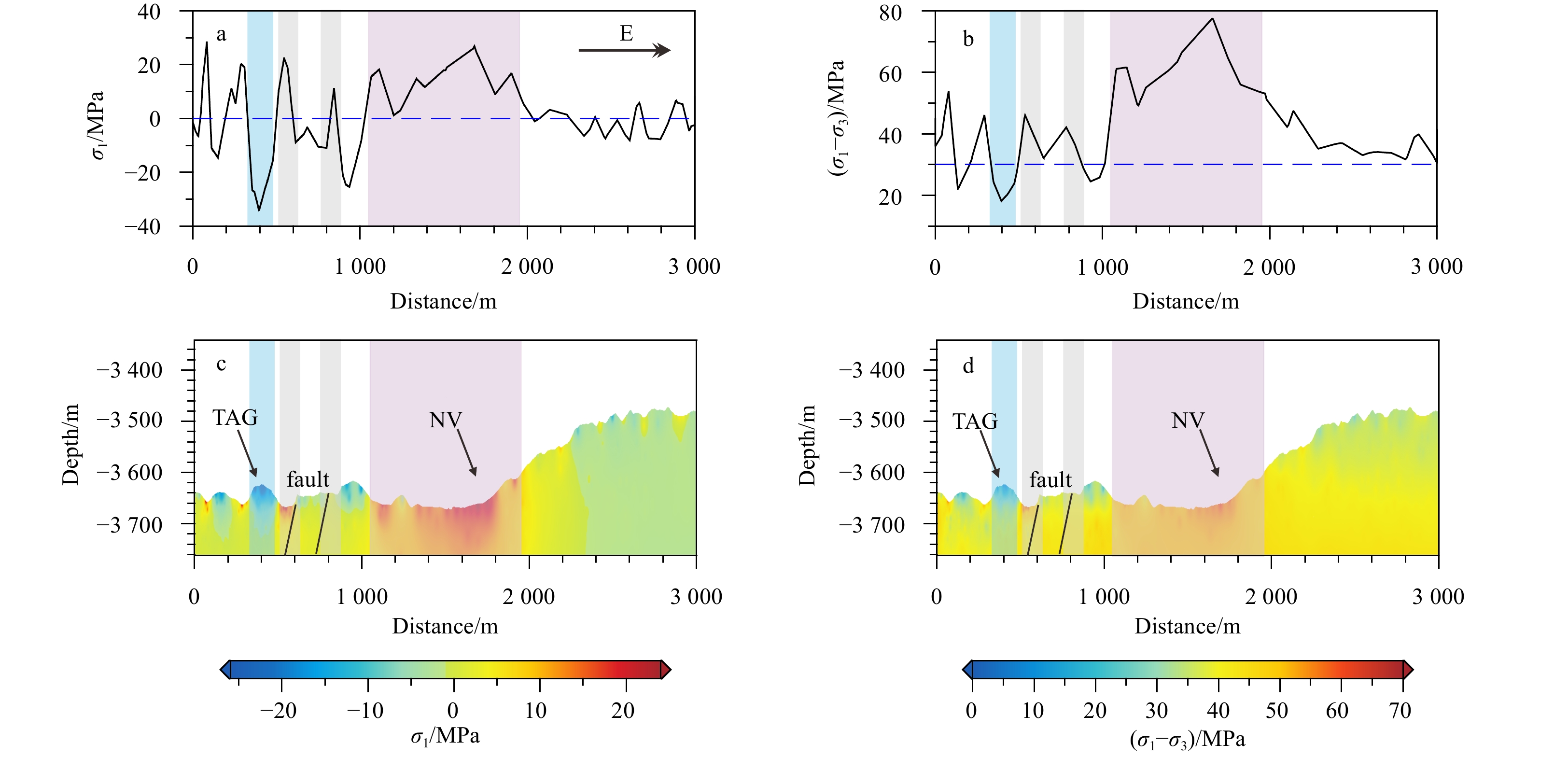
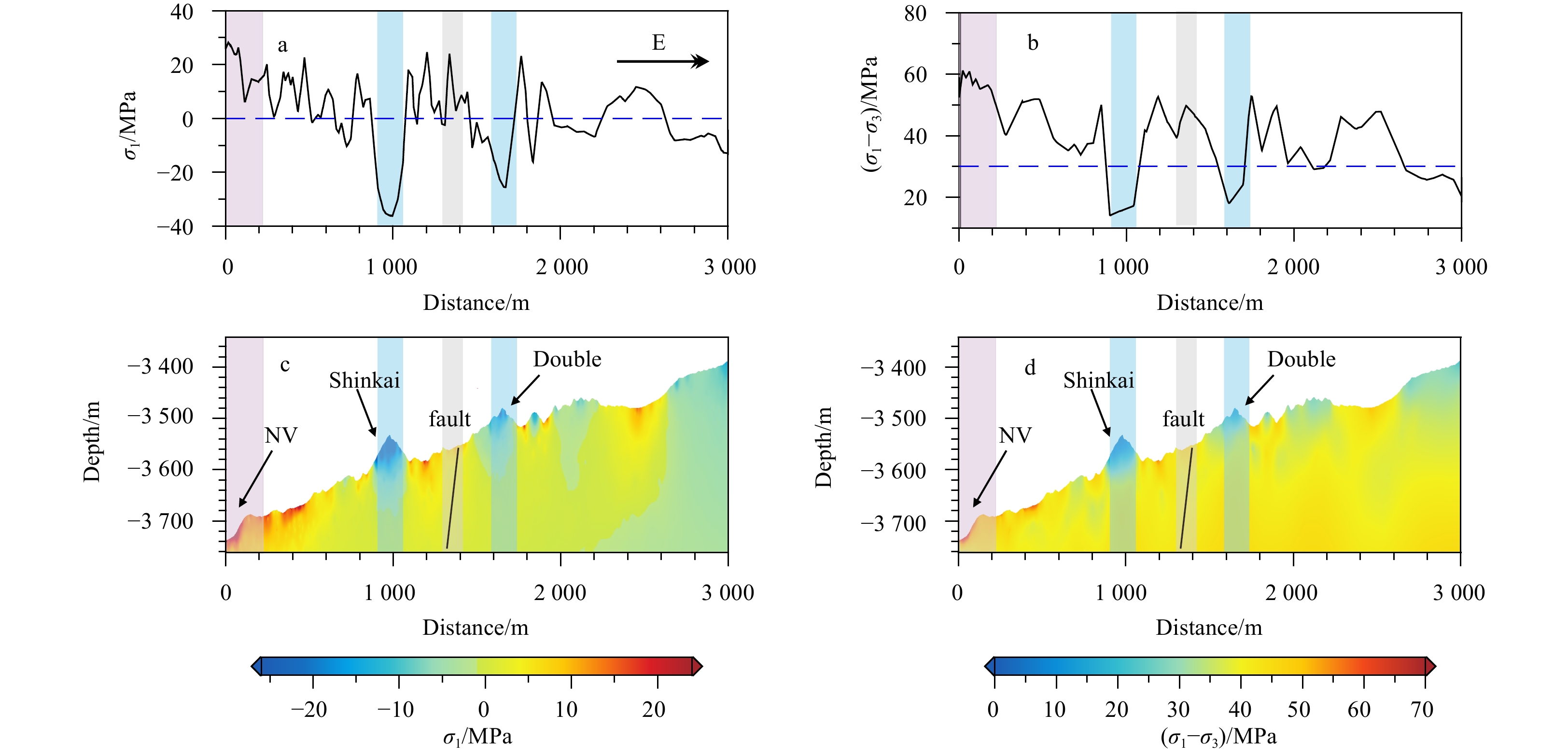
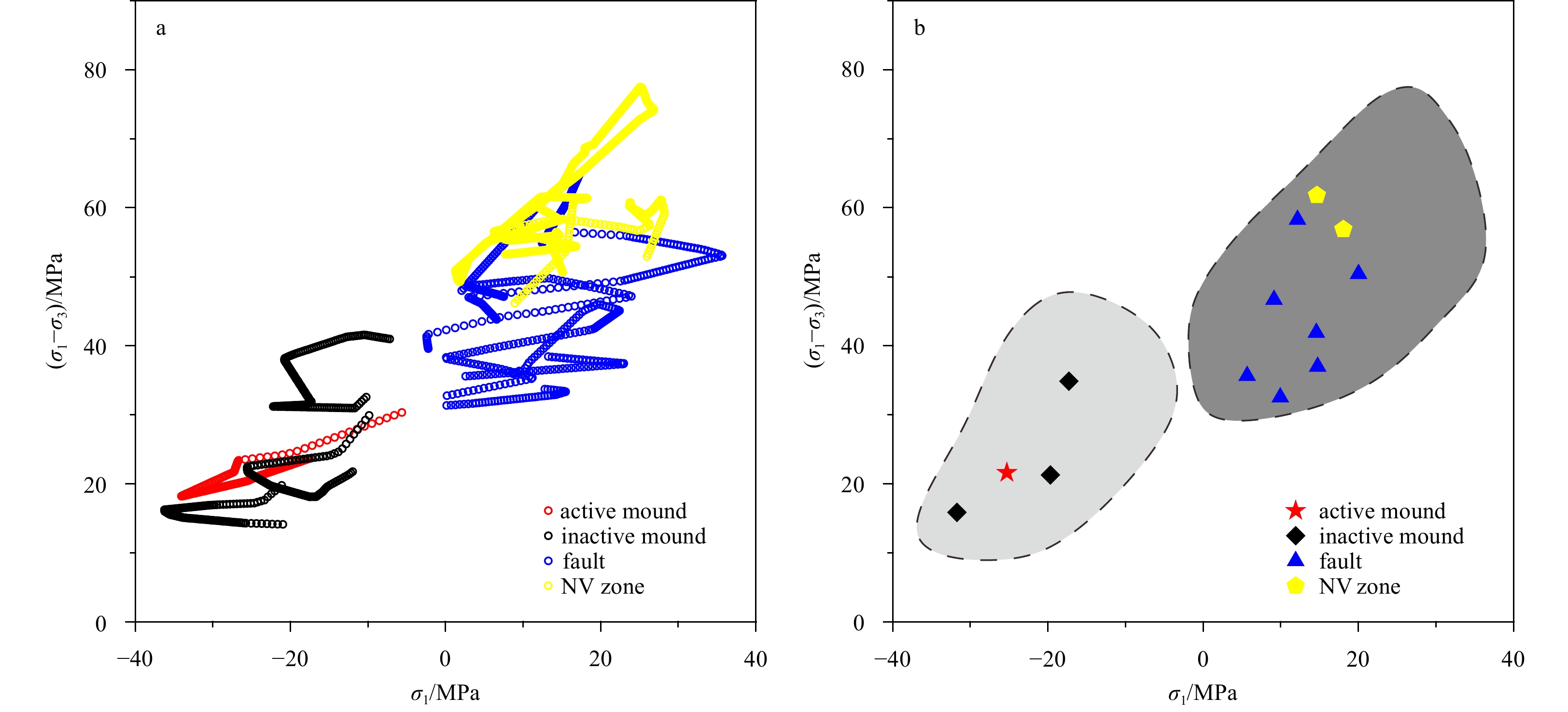
The stress state and rock mechanical properties govern the growth of faults and fractures, which constitute shallow hydrothermal pathways and control the distribution of seafloor massive sulfide (SMS) mounds in the seafloor hydrothermal field. The stress field has an important influence on the formation and persistence of hydrothermal pathways. Based on multibeam bathymetric data from the Trans-Atlantic Geotraverse (TAG) field, we establish two three-dimensional geological models with different scales to simulate the stress field, which investigate the characteristics of hydrothermal pathways and associated SMS mounds. The simulation results show that oblique faults and fissures form in the tensile stress zone and that mounds, including active and inactive hydrothermal mounds form in the compressive stress zone. Fault activity, which is related to the stress field, affects the opening and closing of hydrothermal channels and changes the permeability structure of subseafloor wall rock. Therefore, the stress field controls the development and persistence of shallow hydrothermal pathways. The features of shallow hydrothermal pathways in the stress field can provide geomechanical information that is useful for identifying favorable zone for SMS deposit formation.
Hydrate formation and distribution within unconsolidated sediment: Insights from laboratory electrical resistivity tomography
Yanlong Li, Nengyou Wu, Changling Liu, Qiang Chen, Fulong Ning, Shuoshi Wang, Gaowei Hu, Deli Gao
2022, 41(9): 127-136. doi: 10.1007/s13131-021-1972-2
Abstract:
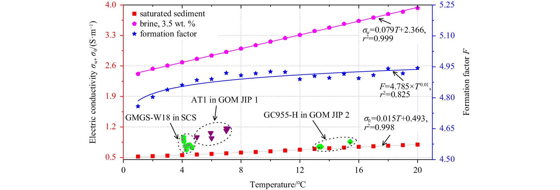
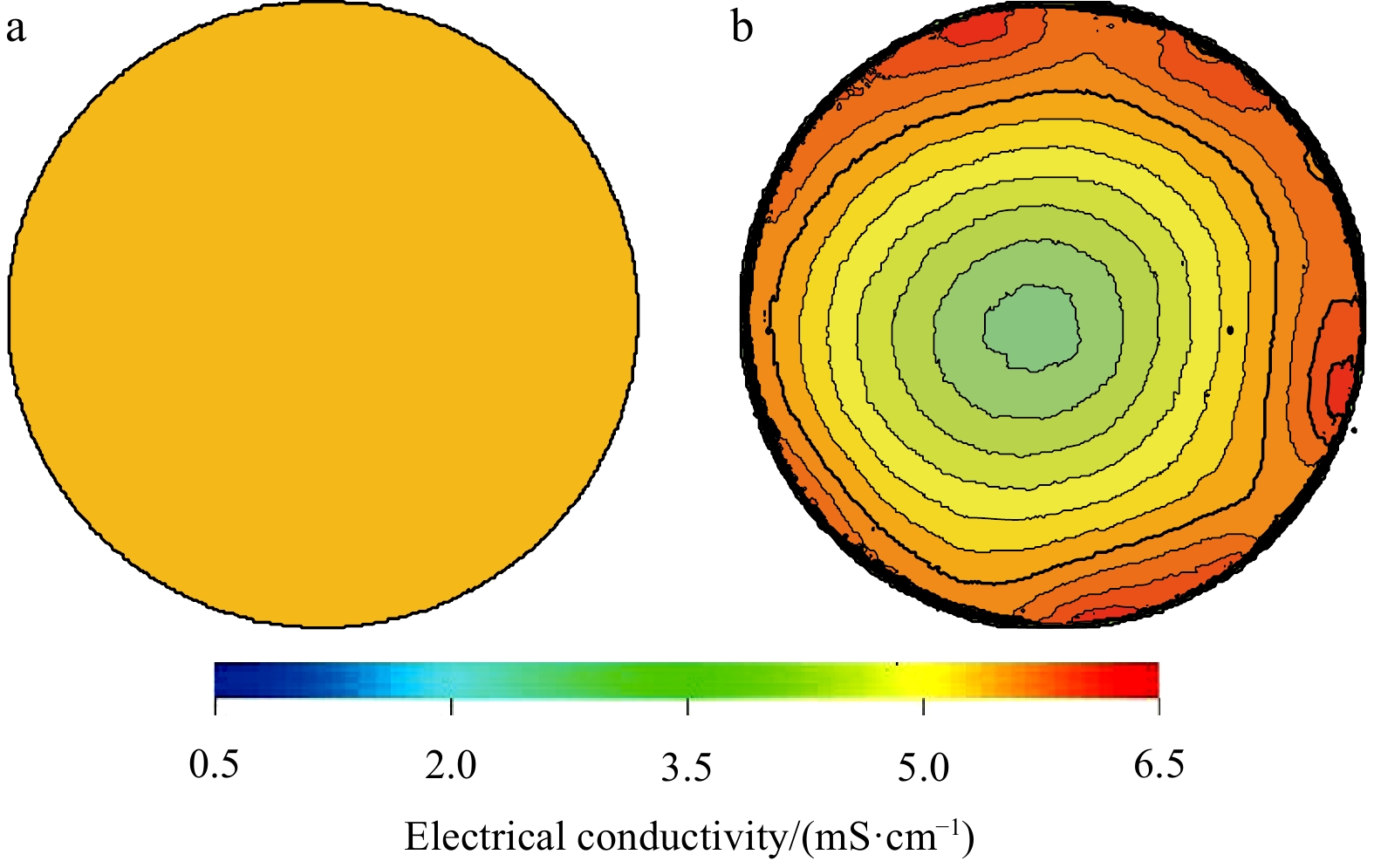
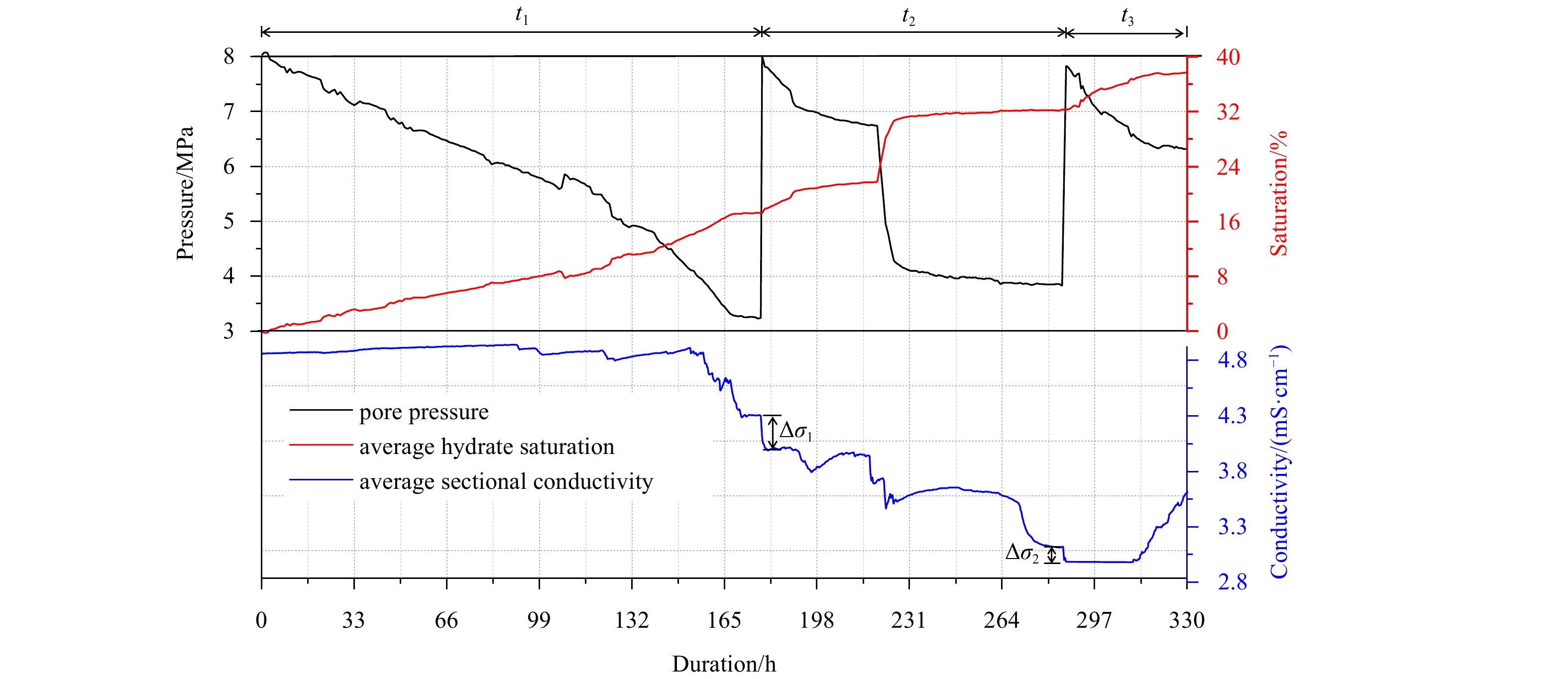
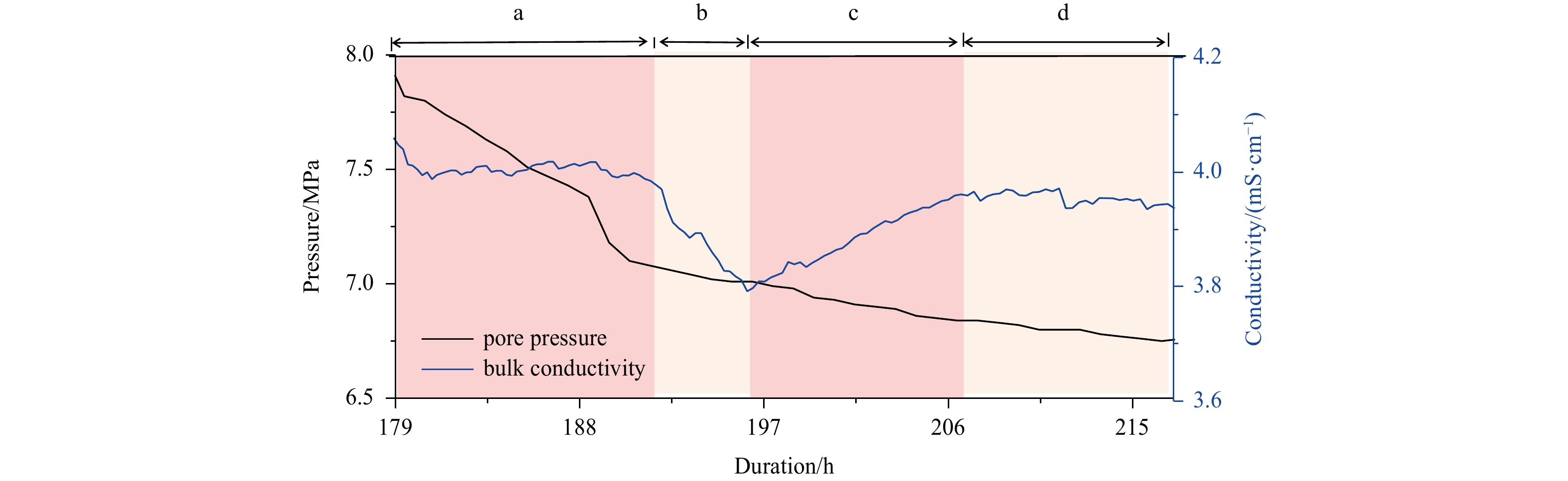
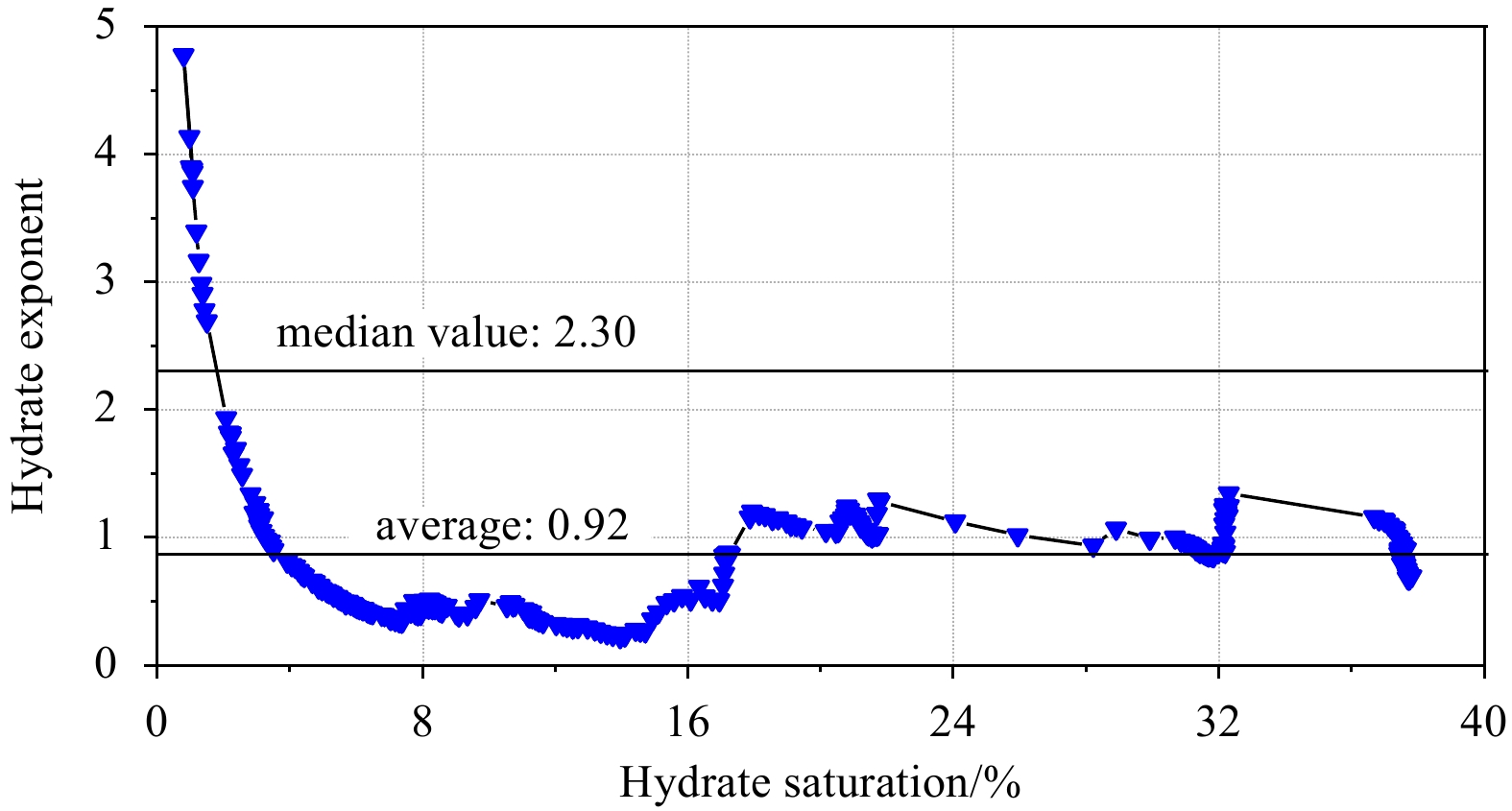
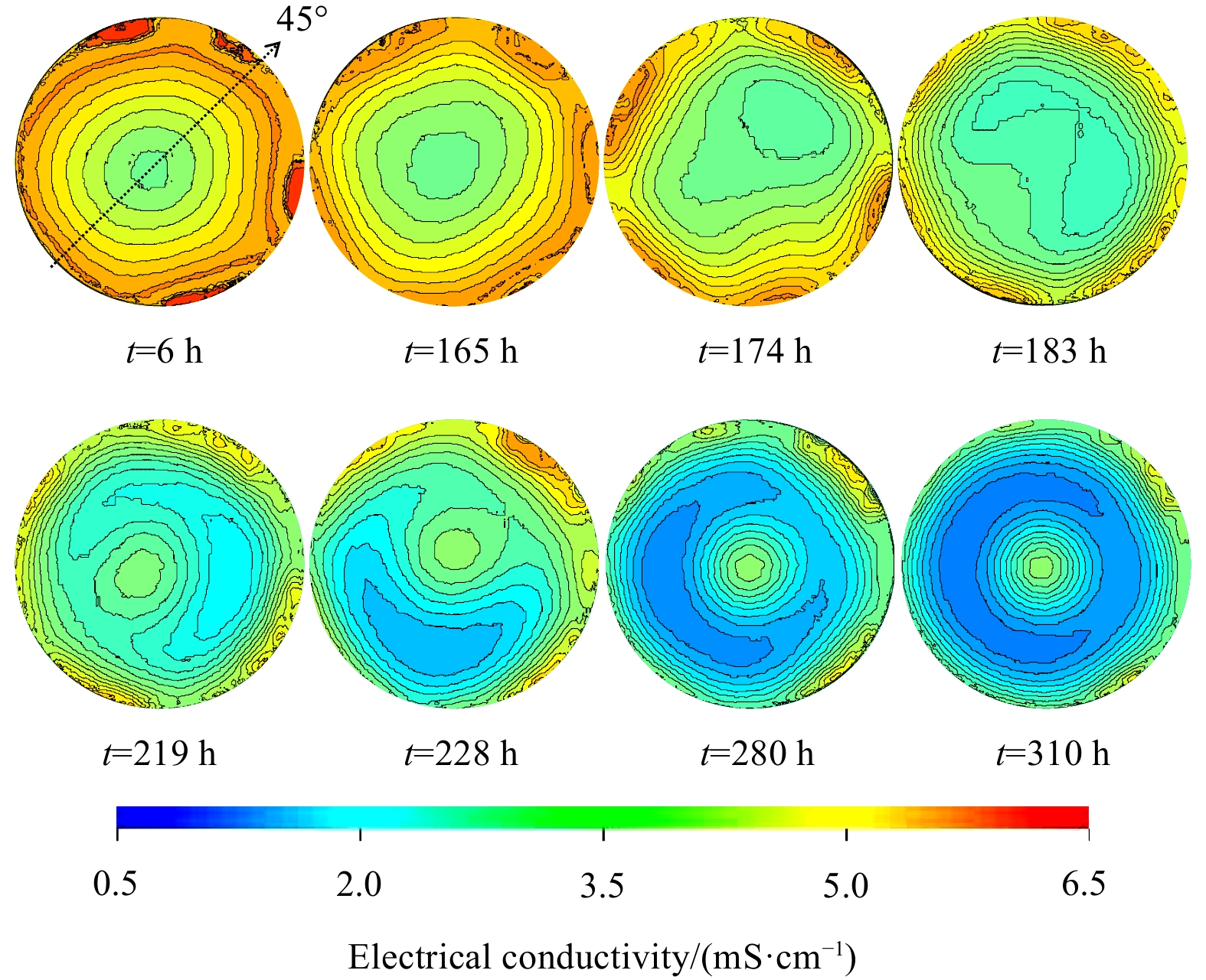
Laboratory visual detection on the hydrate accumulation process provides an effective and low-cost method to uncover hydrate accumulation mechanisms in nature. However, the spatial hydrate distribution and its dynamic evolutionary behaviors are still not fully understood due to the lack of methods and experimental systems. Toward this goal, we built a two-dimensional electrical resistivity tomography (ERT) apparatus capable of measuring spatial and temporal characteristics of hydrate-bearing porous media. Beach sand (0.05–0.85 mm) was used to form artificial methane hydrate-bearing sediment. The experiments were conducted at 1°C under excess water conditions and the ERT data were acquired and analyzed. This study demonstrates the utility of the ERT method for hydrate mapping in laboratory-scale. The results indicate that the average electrical conductivity decreases nonlinearly with the formation of the hydrate. At some special time-intervals, the average conductivity fluctuates within a certain scope. The plane conductivity fields evolve heterogeneously and the local preferential hydrate-forming positions alternate throughout the experimental duration. We speculate that the combination of hydrate formation itself and salt-removal effect plays a dominant role in the spatial and temporal hydrate distribution, as well as geophysical parameters changing behaviors during hydrate accumulation.
Articles$Marine Technology
Multisatellite observations of smaller mesoscale eddy generation in the Kuroshio Extension
Fangjie Yu, Meiyu Wang, Sijia Qian, Ge Chen
2022, 41(9): 137-148. doi: 10.1007/s13131-022-1996-2
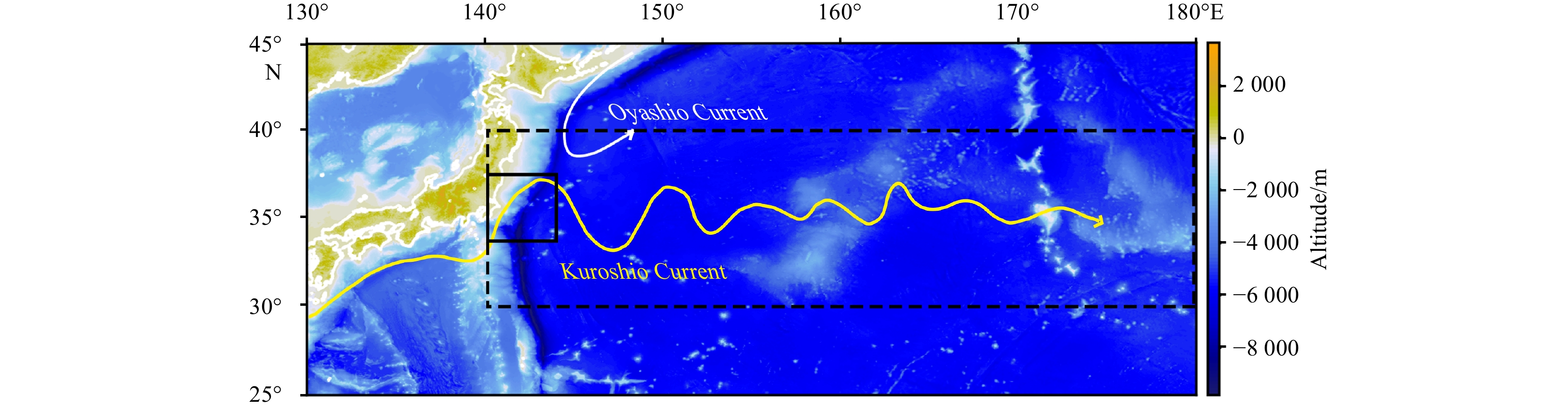
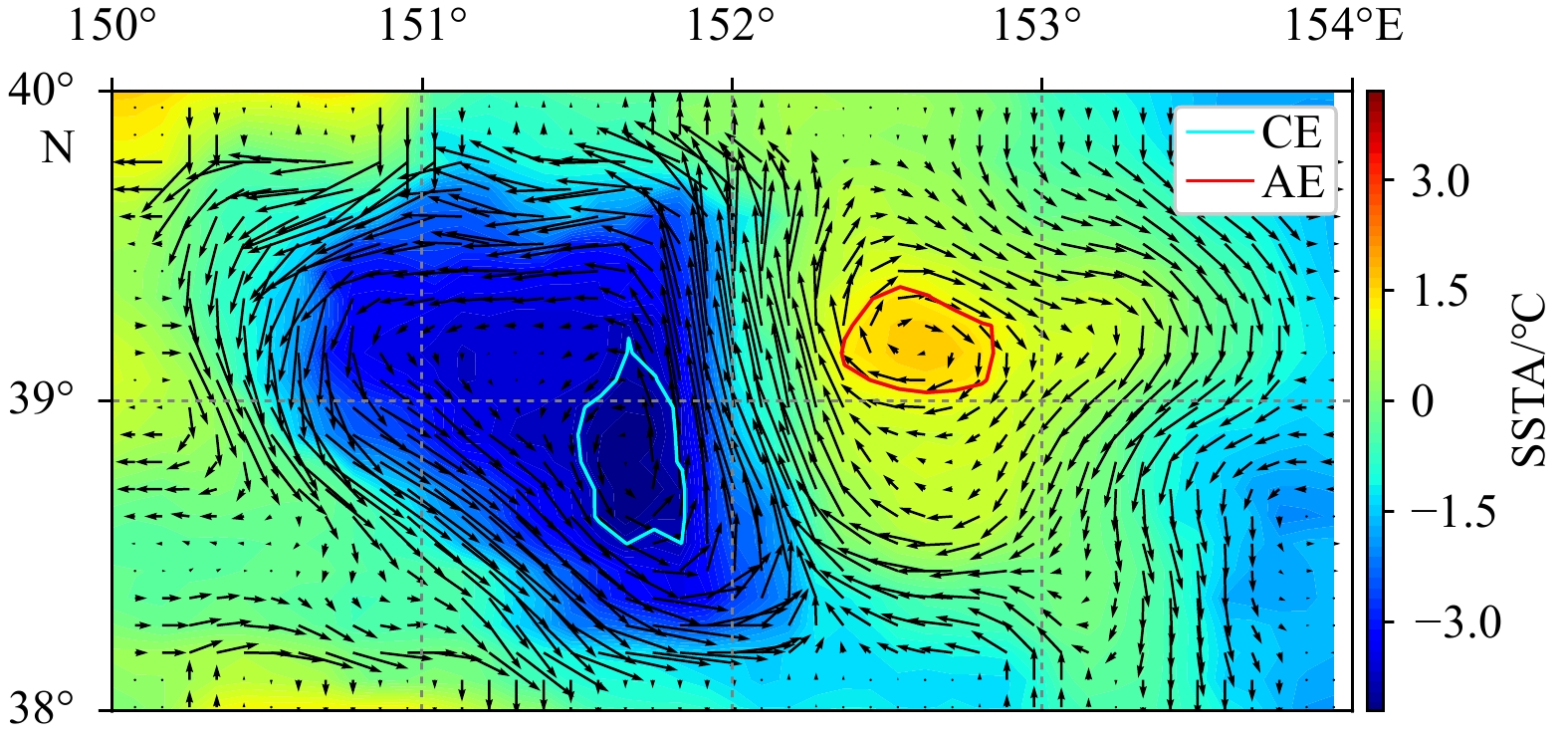
Abstract:
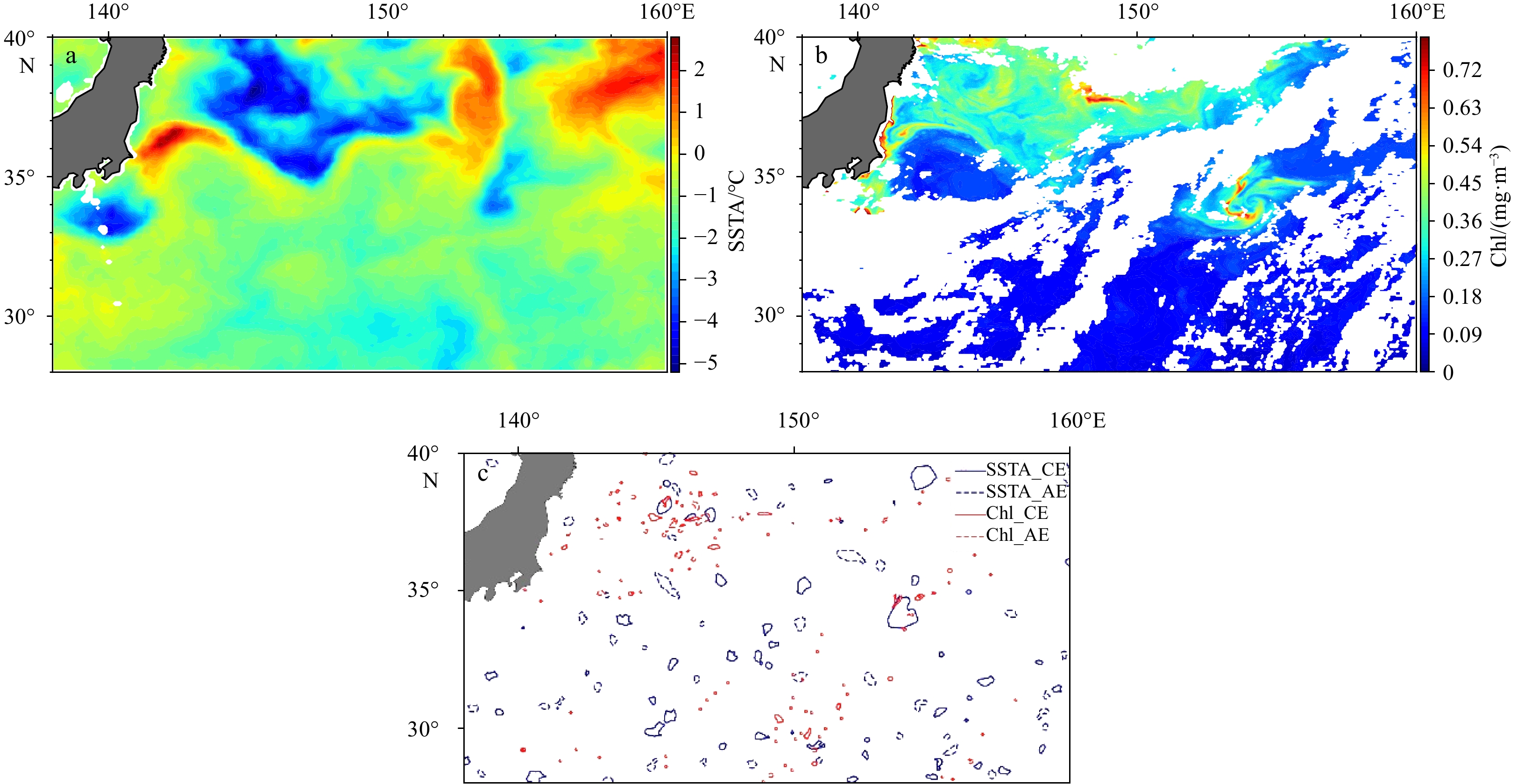
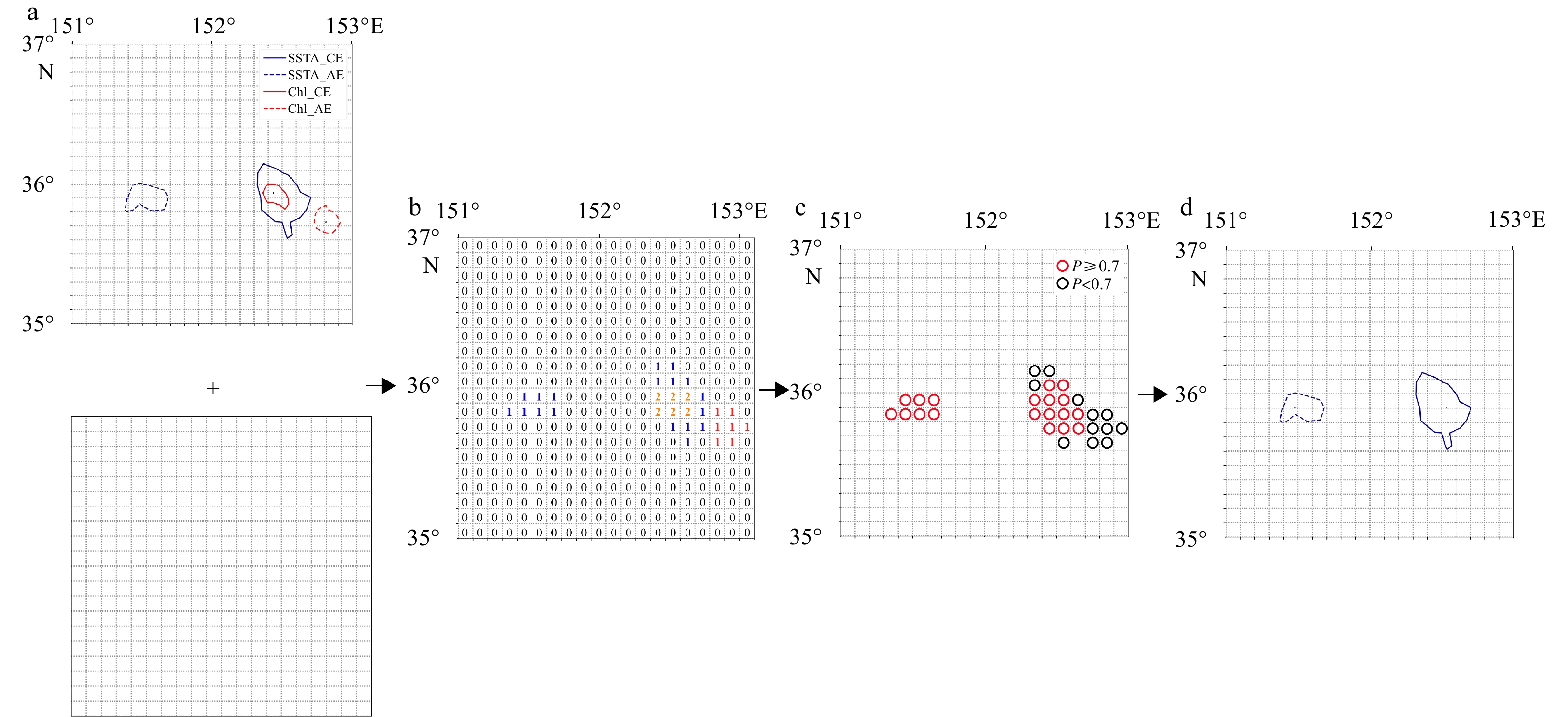
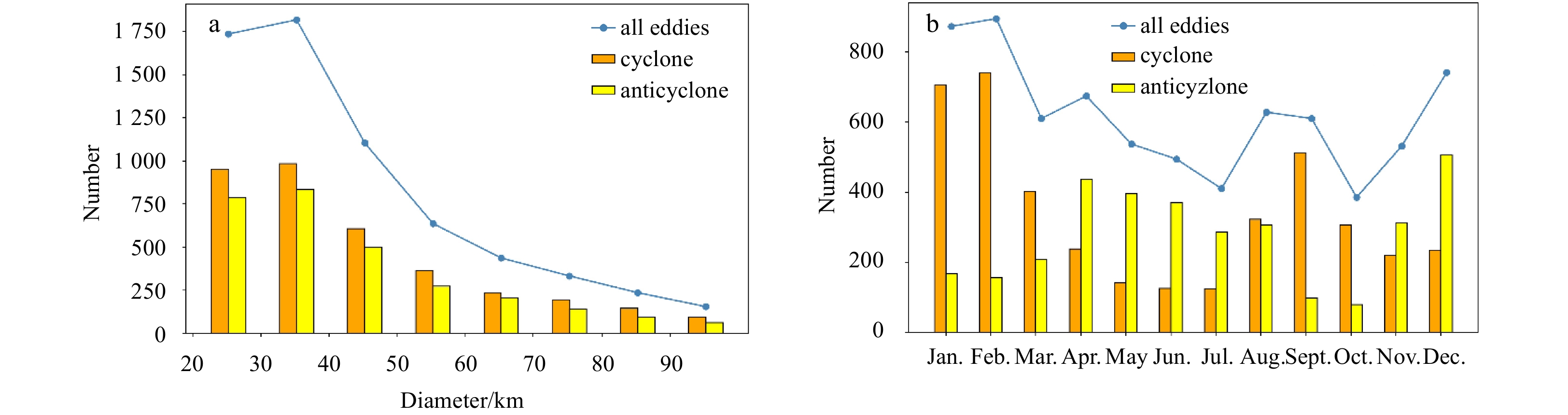
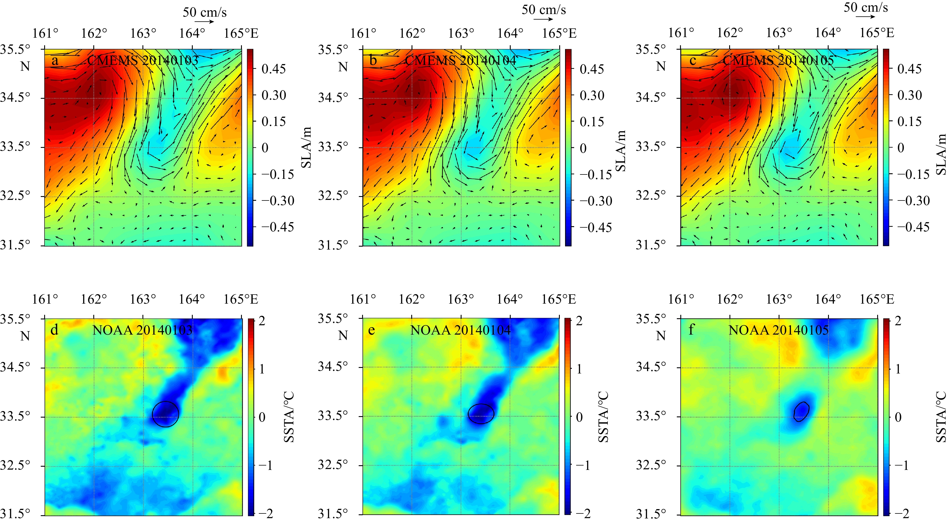
Smaller mesoscale eddies (SMEs) have an important effect on the transmission of ocean temperatures, salinity, energy, and marine biochemical processes. However, traditional altimeters, the dominant sensors used to identify and track eddies, have made it challenging to observe SMEs accurately due to resolution limitations. Eddies drive local upwelling or downwelling, leaving signatures on sea surface temperatures (SSTs) and chlorophyll concentrations (Chls). SST can be observed by spaceborne infrared sensors, and Chl can be measured by ocean color remote sensing. Therefore, multisatellite observations provide an opportunity to obtain information to characterize SMEs. In this paper, an eddy detection algorithm based on SST and Chl images is proposed, which identifies eddies by characterizing the spatial and temporal distribution of SST and Chl data. The algorithm is applied to characterize and analyze SMEs in the Kuroshio Extension. Statistical results on their distribution and seasonal variability are shown, and the formation processes are preliminarily discussed. SMEs generation may be contributed by horizontal strain instability, the interaction of topographic obstacles and currents, and wind stress curl.
Optical flow-based method to estimate internal wave parameters from X-band marine radar images
Jinghan Wen, Zhongbiao Chen, Yijun He
2022, 41(9): 149-157. doi: 10.1007/s13131-022-1988-2
Abstract:
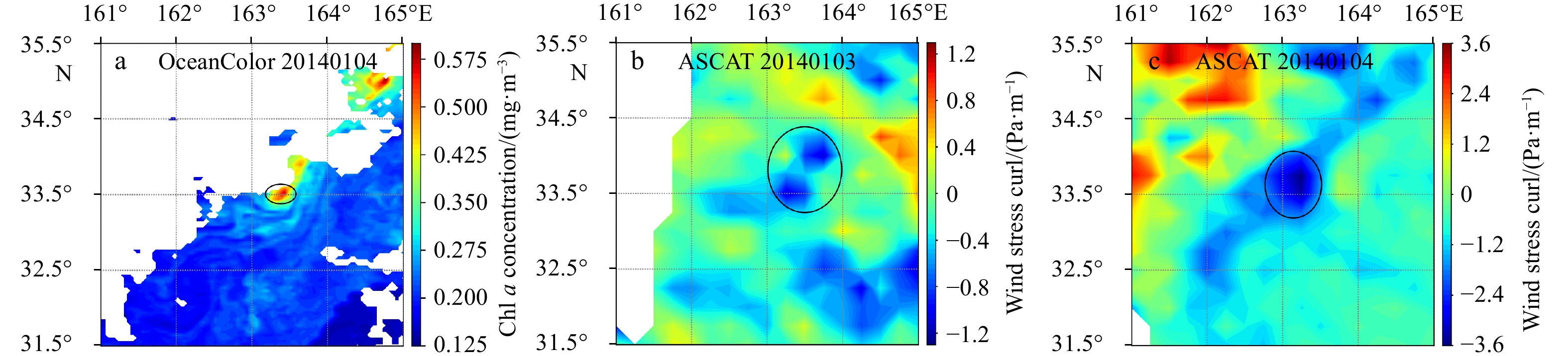
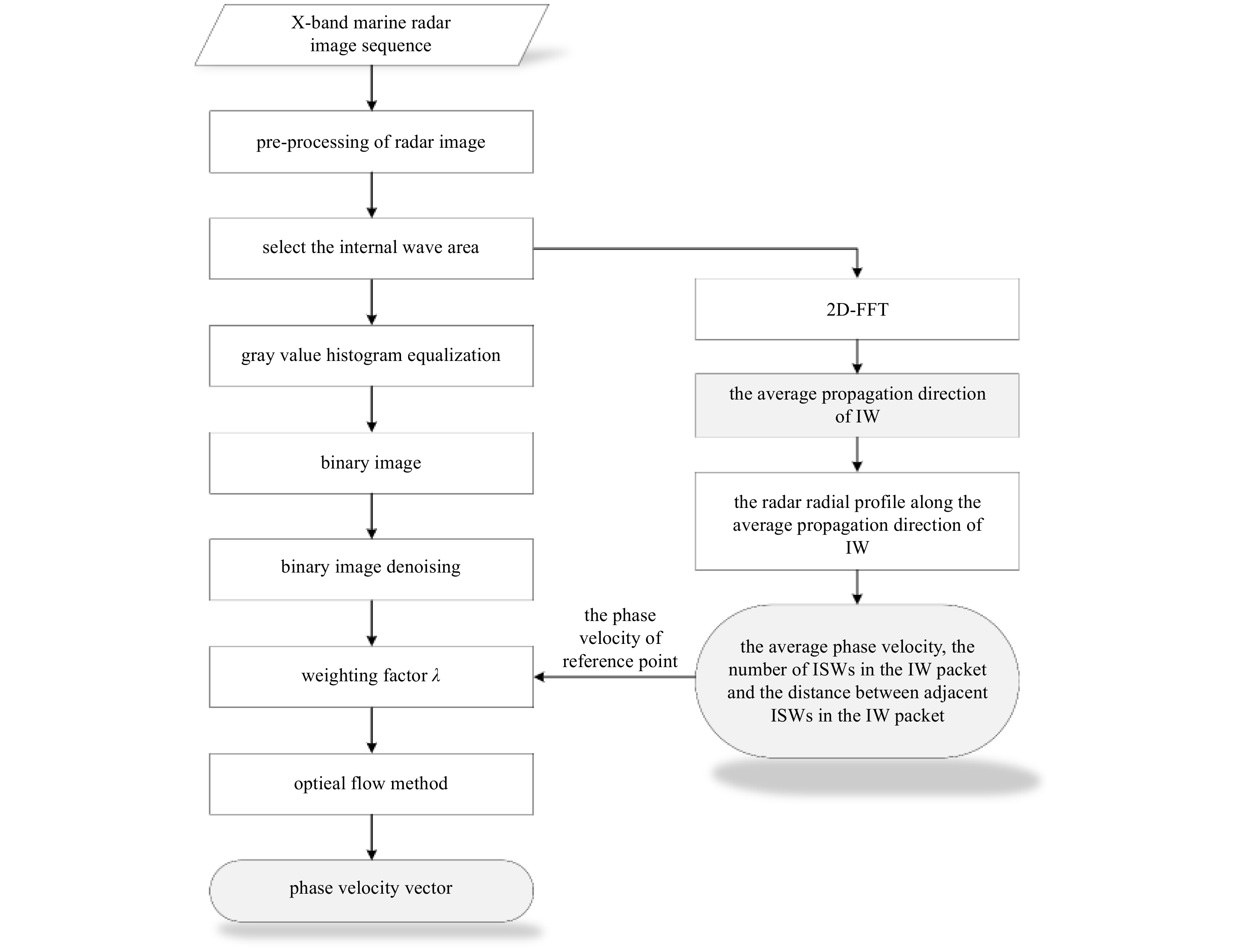
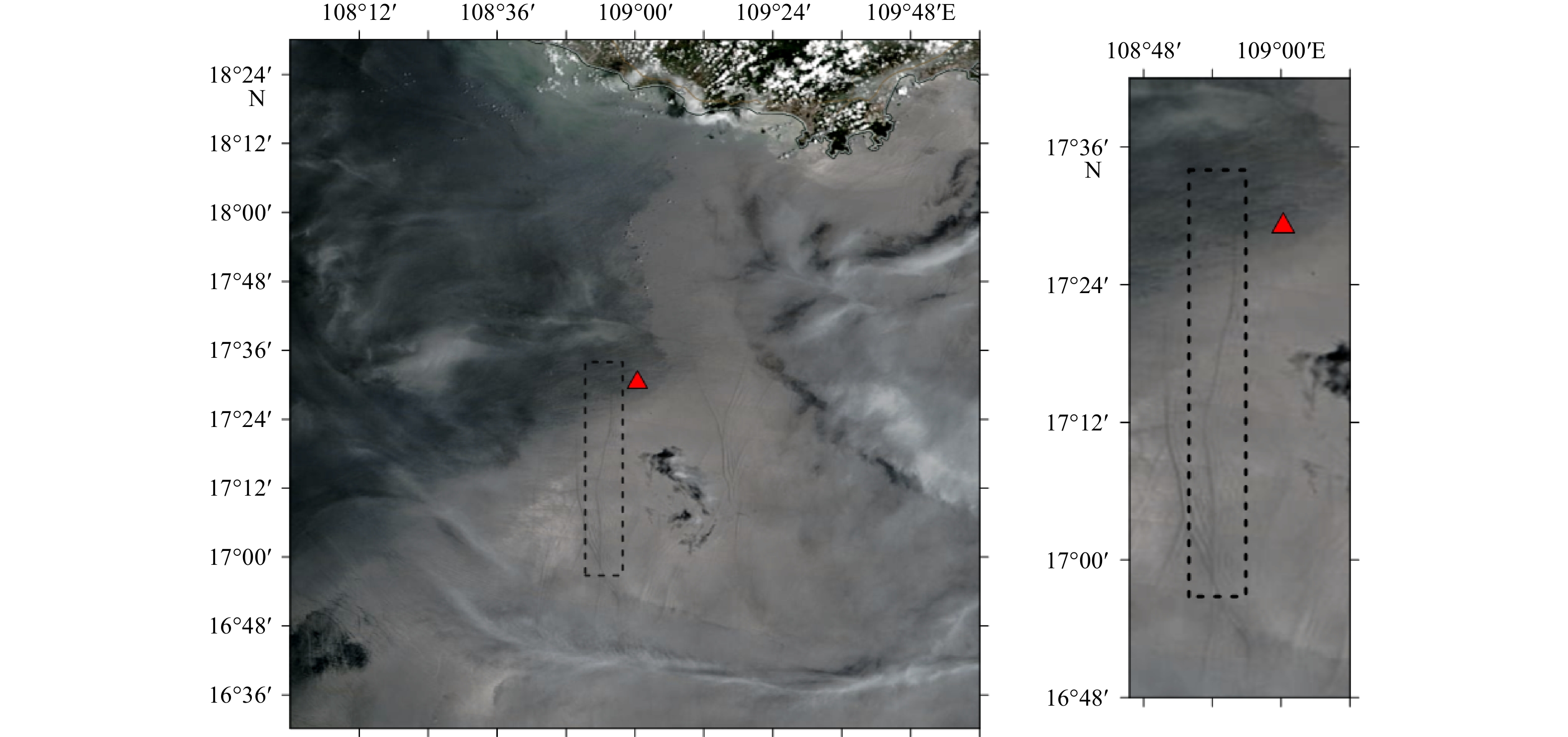
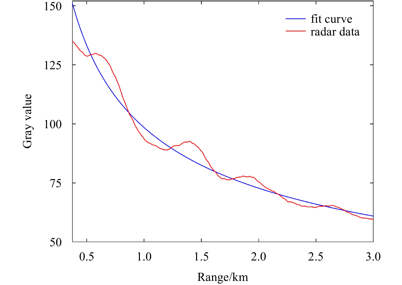
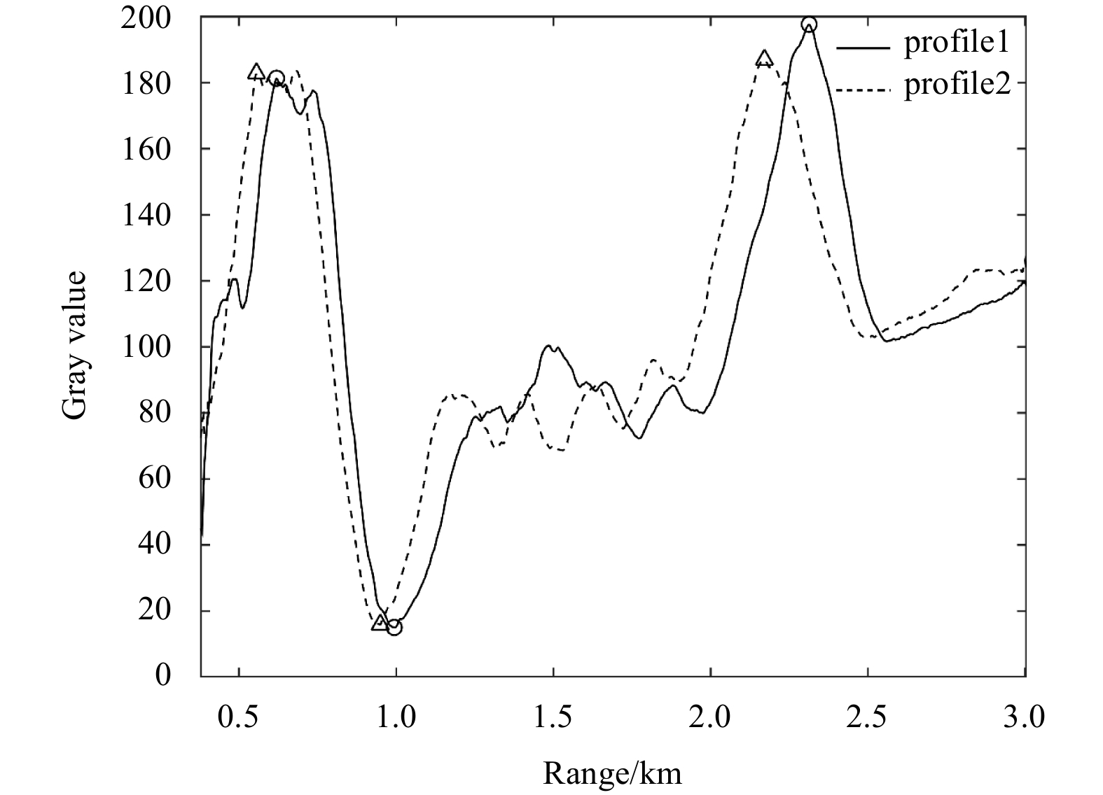
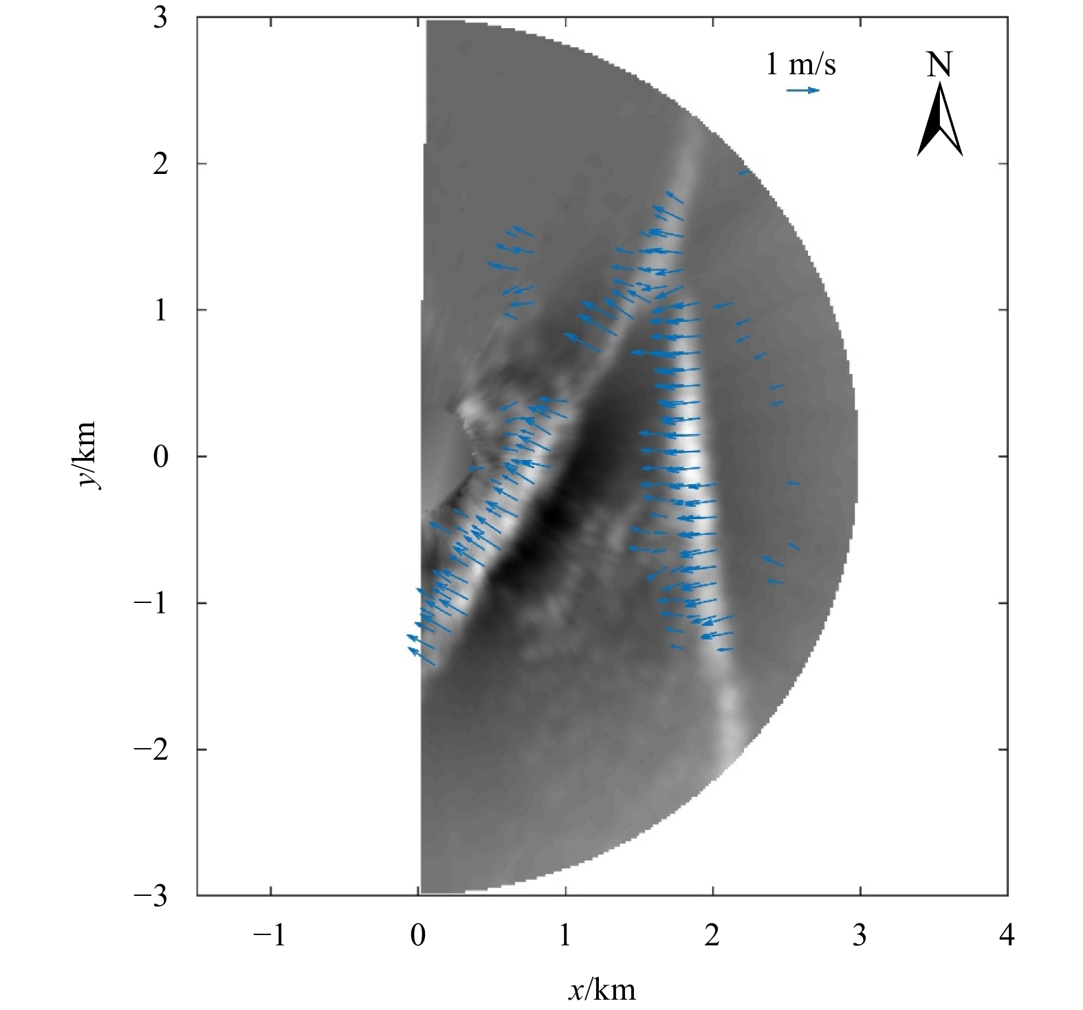
The velocity and direction of internal waves (IWs) are important parameters of the ocean, however, traditional observation methods can only obtain the average parameters of IWs for a single location or large area. Herein, a new method based on optical flow is proposed to derive the phase velocity vectors of IWs from X-band marine radar images. First, the X-band marine radar image sequence is averaged, and ramp correction is used to reduce the attenuation of gray values with increasing radial range. Second, the average propagation direction of the IWs is determined using the two-dimensional Fourier transform of the radar images; two radial profiles along this direction are selected from two adjacent radar images; and then, the average phase velocity of the IWs is estimated from these radial profiles. Third, the averaged radar images are processed via histogram equalization and binarization to reduce the influence of noise on the radar images. Fourth, a weighting factor is determined using the average phase velocity of a reference point; the phase velocities on the wave crest of the IWs are subsequently estimated via the optical flow method. Finally, the proposed method is validated using X-band marine radar image sequences observed on an oil platform in the South China Sea, and the error of the phase velocity is calculated to be 0.000 3–0.073 8 m/s. The application conditions of the proposed method are also discussed using two different types of IW packets.
A GPU accelerated Boussinesq-type model for coastal waves
Kezhao Fang, Jiawen Sun, Guangchun Song, Gang Wang, Hao Wu, Zhongbo Liu
2022, 41(9): 158-168. 
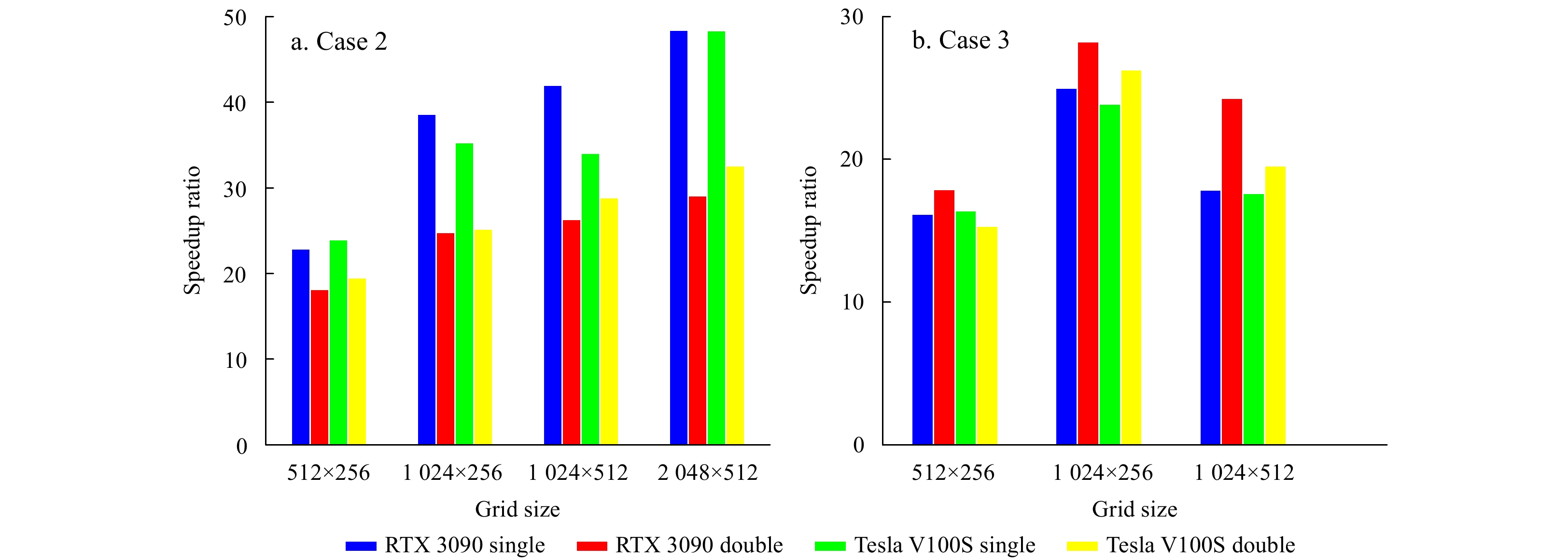
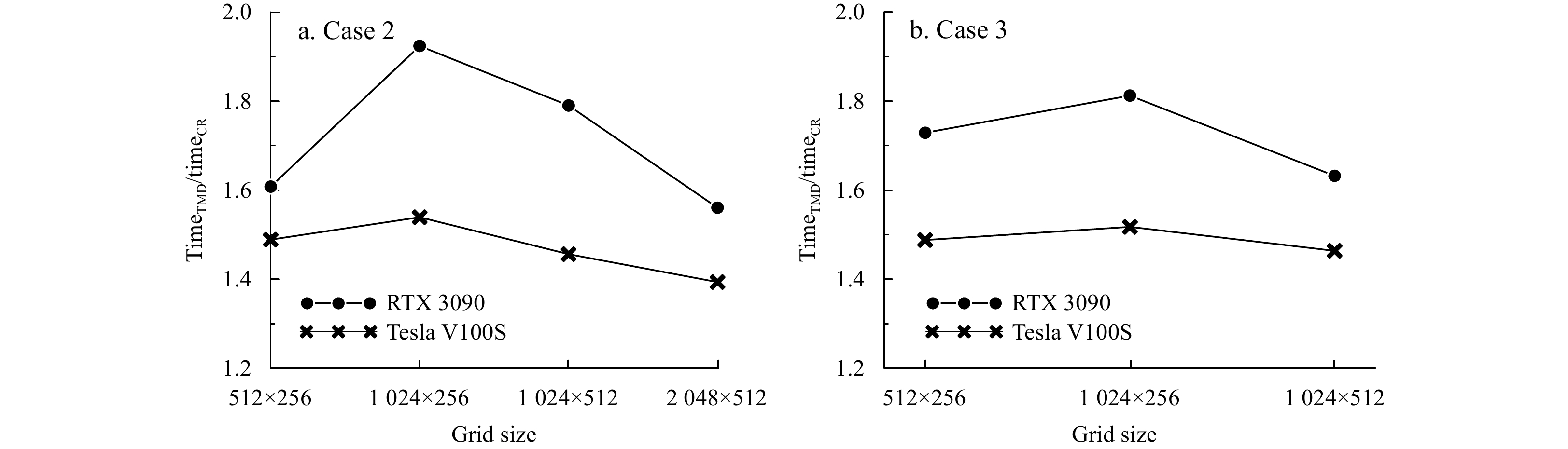
doi: 10.1007/s13131-022-2004-6
Abstract:
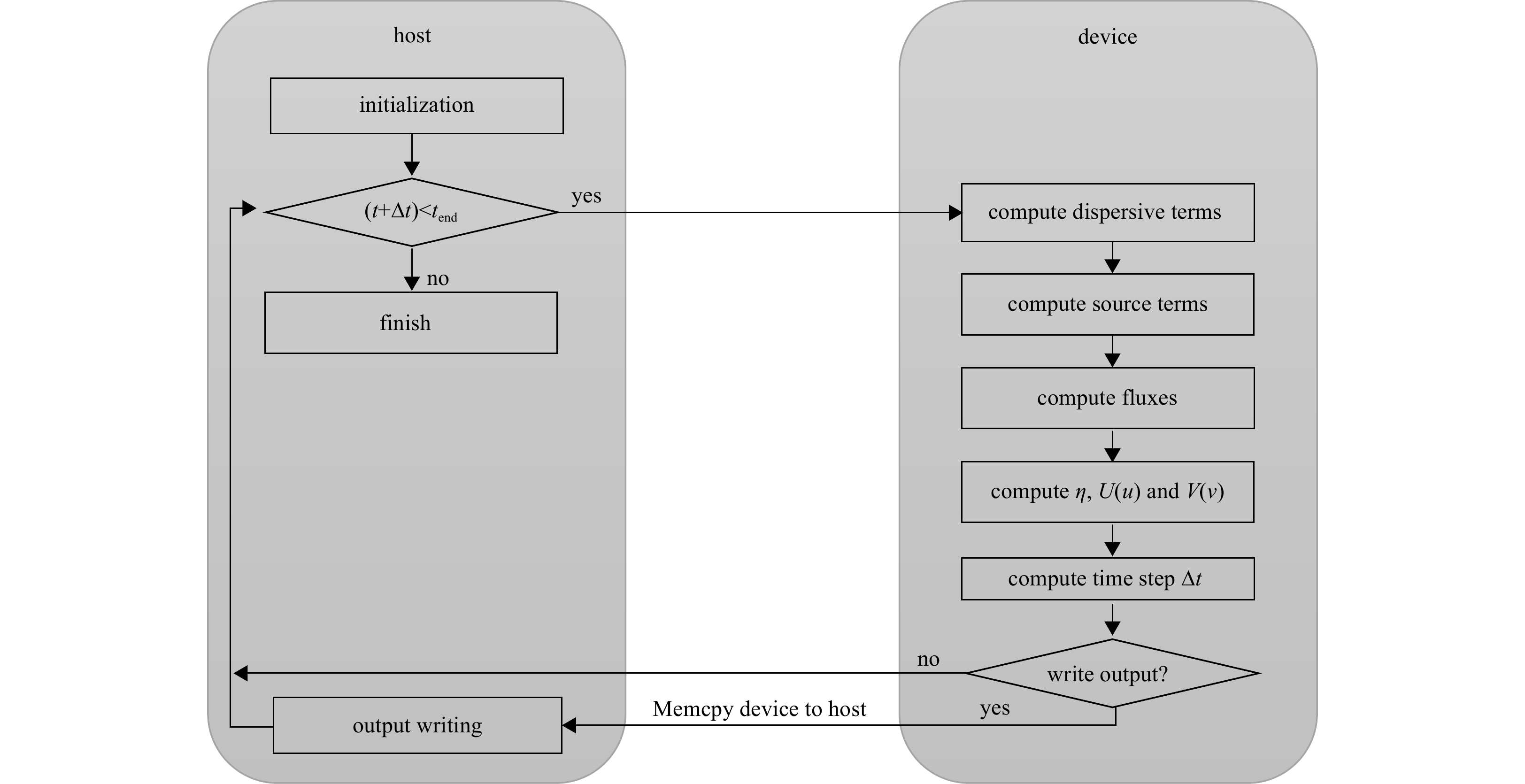
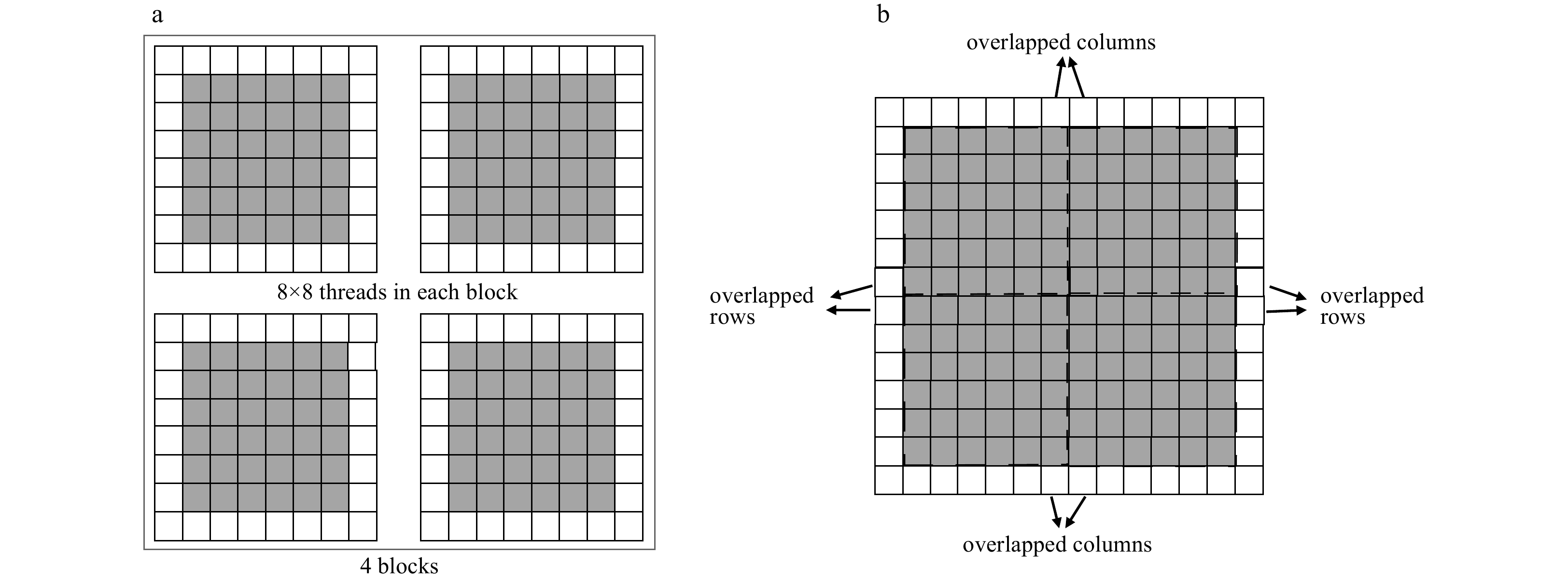
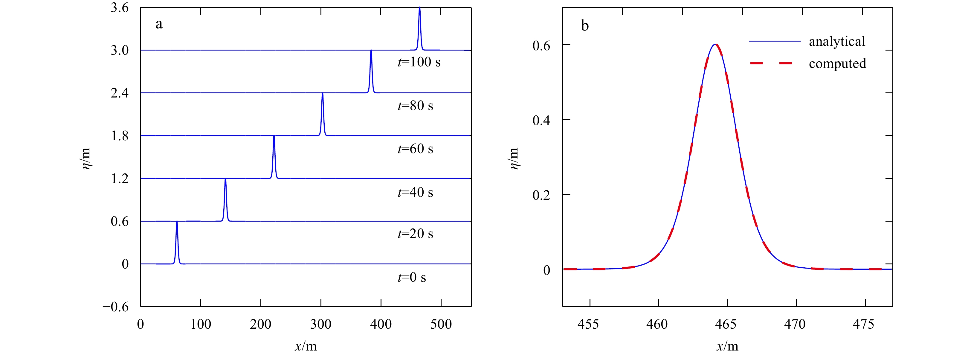
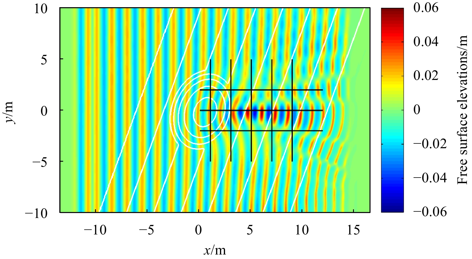
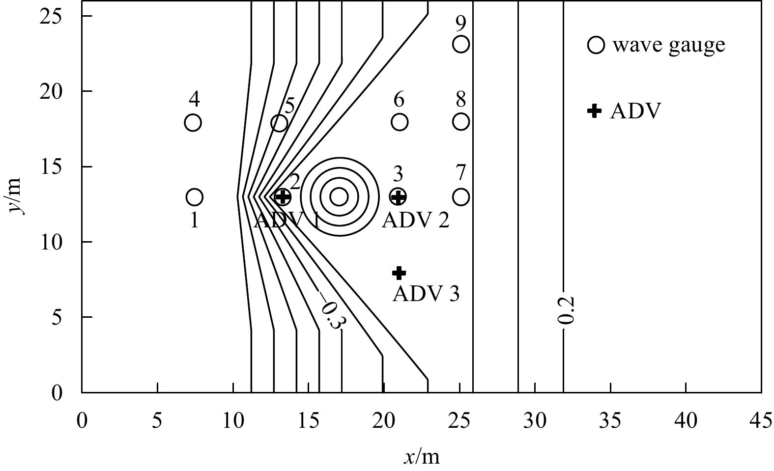
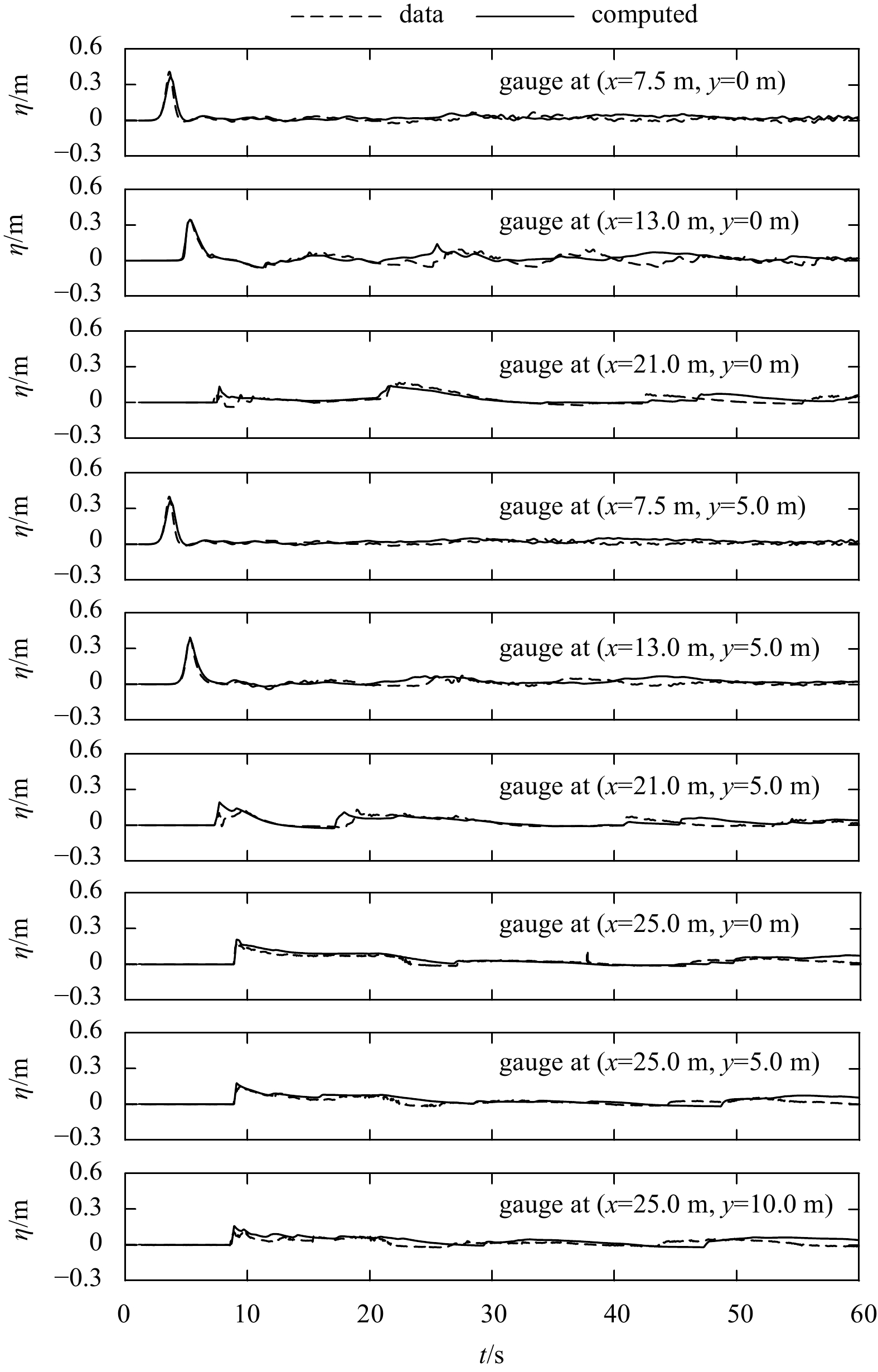
This study presents an efficient Boussinesq-type wave model accelerated by a single Graphics Processing Unit (GPU). The model uses the hybrid finite volume and finite difference method to solve weakly dispersive and nonlinear Boussinesq equations in the horizontal plane, enabling the model to have the shock-capturing ability to deal with breaking waves and moving shoreline properly. The code is written in CUDA C. To achieve better performance, the model uses cyclic reduction technique to solve massive tridiagonal linear systems and overlapped tiling/shared memory to reduce global memory access and enhance data reuse. Four numerical tests are conducted to validate the GPU implementation. The performance of the GPU model is evaluated by running a series of numerical simulations on two GPU platforms with different hardware configurations. Compared with the CPU version, the maximum speedup ratios for single-precision and double-precision calculations are 55.56 and 32.57, respectively.
Articles$Marine Information Science
Arctic summer sea ice phenology including ponding from 1982 to 2017
Xiaoli Chen, Chunxia Zhou, Lei Zheng, Mingci Li, Yong Liu, Tingting Liu
2022, 41(9): 169-181. doi: 10.1007/s13131-022-1993-5
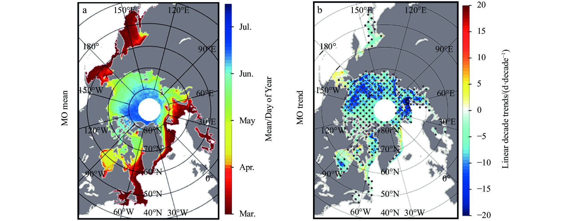
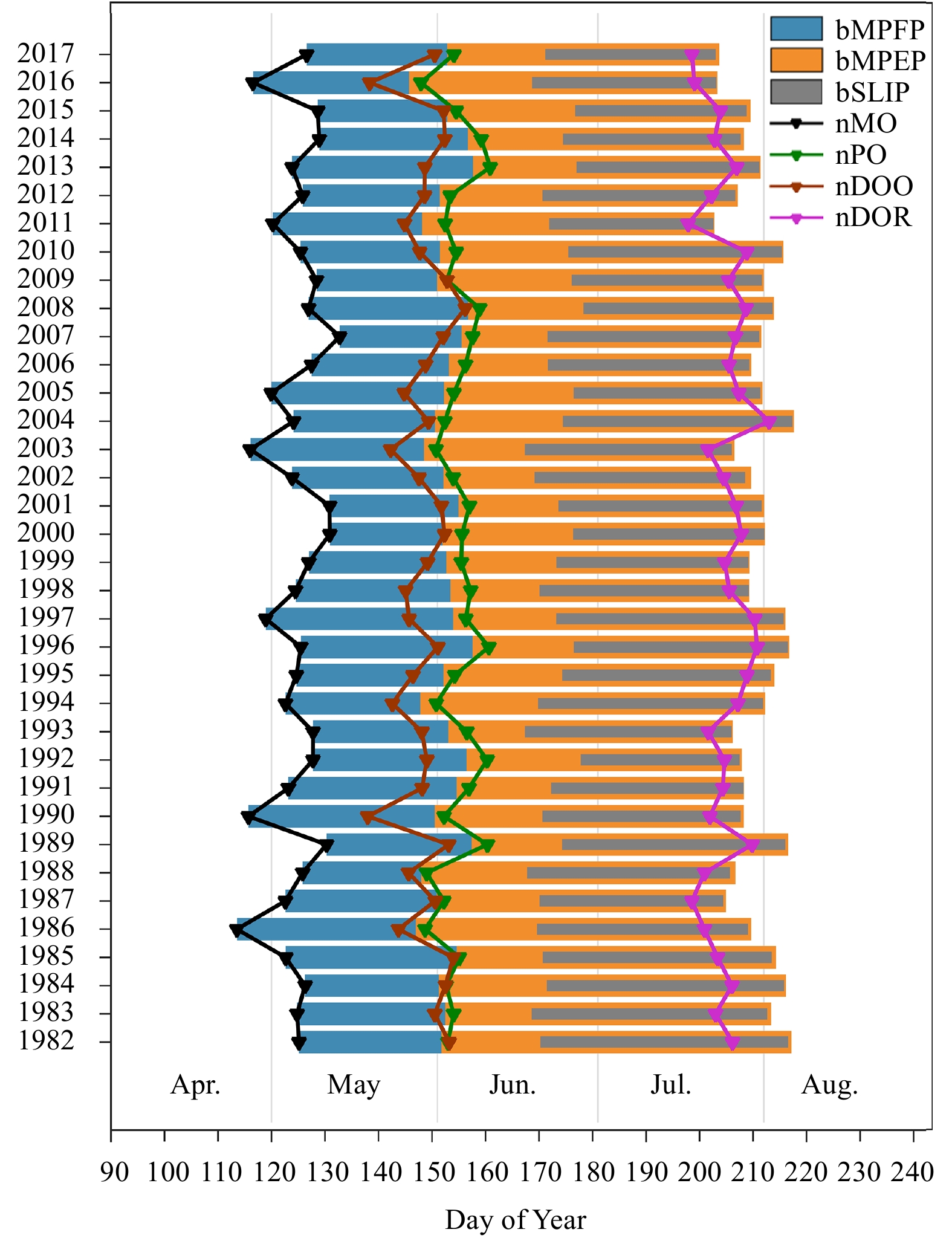
Abstract:
Information on the Arctic sea ice climate indicators is crucial to business strategic planning and climate monitoring. Data on the evolvement of the Arctic sea ice and decadal trends of phenology factors during melt season are necessary for climate prediction under global warming. Previous studies on Arctic sea ice phenology did not involve melt ponds that dramatically lower the ice surface albedo and tremendously affect the process of sea ice surface melt. Temporal means and trends of the Arctic sea ice phenology from 1982 to 2017 were examined based on satellite-derived sea ice concentration and albedo measurements. Moreover, the timing of ice ponding and two periods corresponding to it were newly proposed as key stages in the melt season. Therefore, four timings, i.e., date of snow and ice surface melt onset (MO), date of pond onset (PO), date of sea ice opening (DOO), and date of sea ice retreat (DOR); and three durations, i.e., melt pond formation period (MPFP, i.e., MO–PO), melt pond extension period (MPEP, i.e., PO–DOR), and seasonal loss of ice period (SLIP, i.e., DOO–DOR), were used. PO ranged from late April in the peripheral seas to late June in the central Arctic Ocean in Bootstrap results, whereas the pan-Arctic was observed nearly 4 days later in NASA Team results. Significant negative trends were presented in the MPEP in the Hudson Bay, the Baffin Bay, the Greenland Sea, the Kara and Barents seas in both results, indicating that the Arctic sea ice undergoes a quick transition from ice to open water, thereby extending the melt season year to year. The high correlation coefficient between MO and PO, MPFP illustrated that MO predominates the process of pond formation.
A hybrid forecasting model for depth-averaged current velocities of underwater gliders
Yaojian Zhou, Yonglai Zhang, Wenai Song, Shijie Liu, Baoqiang Tian
2022, 41(9): 182-191. doi: 10.1007/s13131-022-1994-4
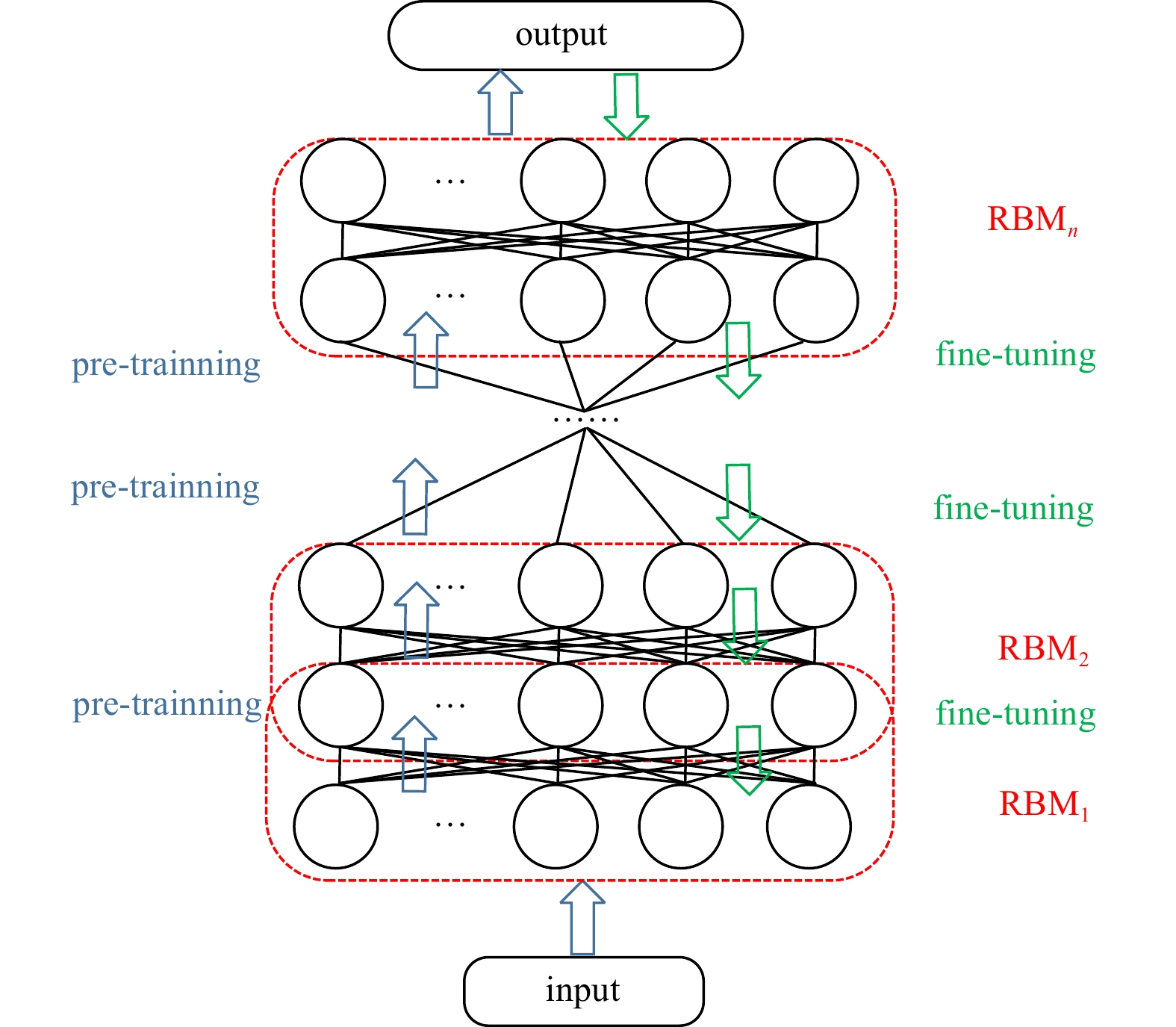
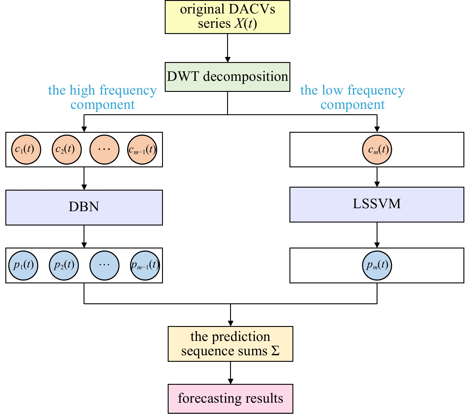
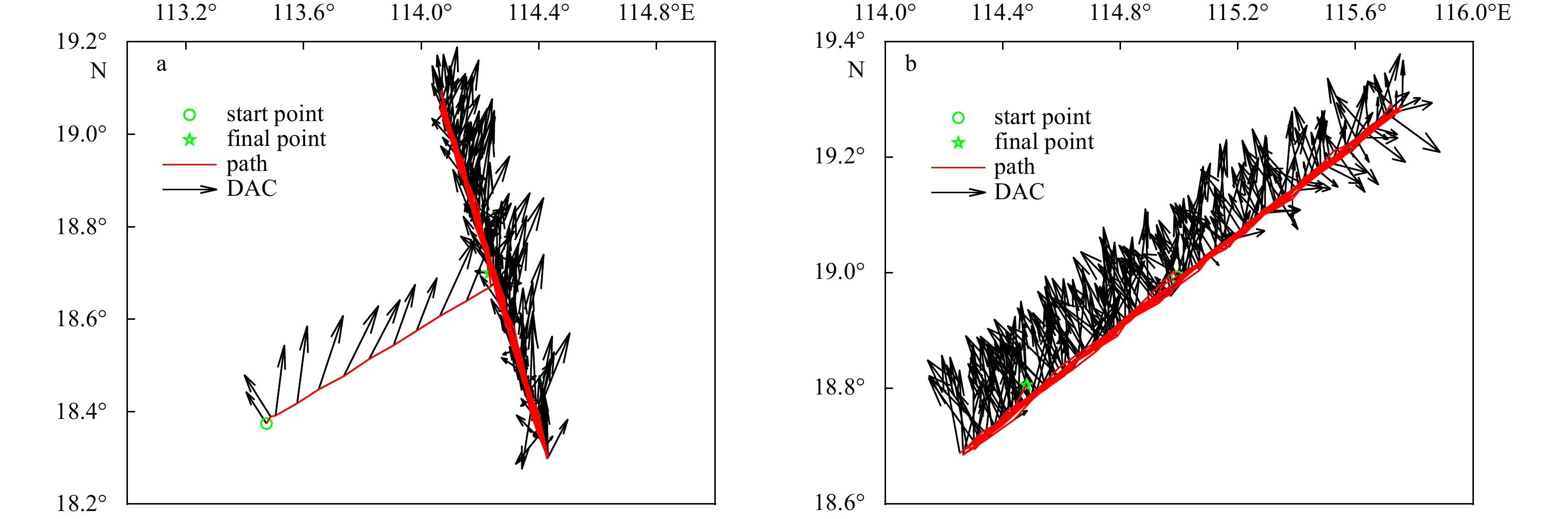
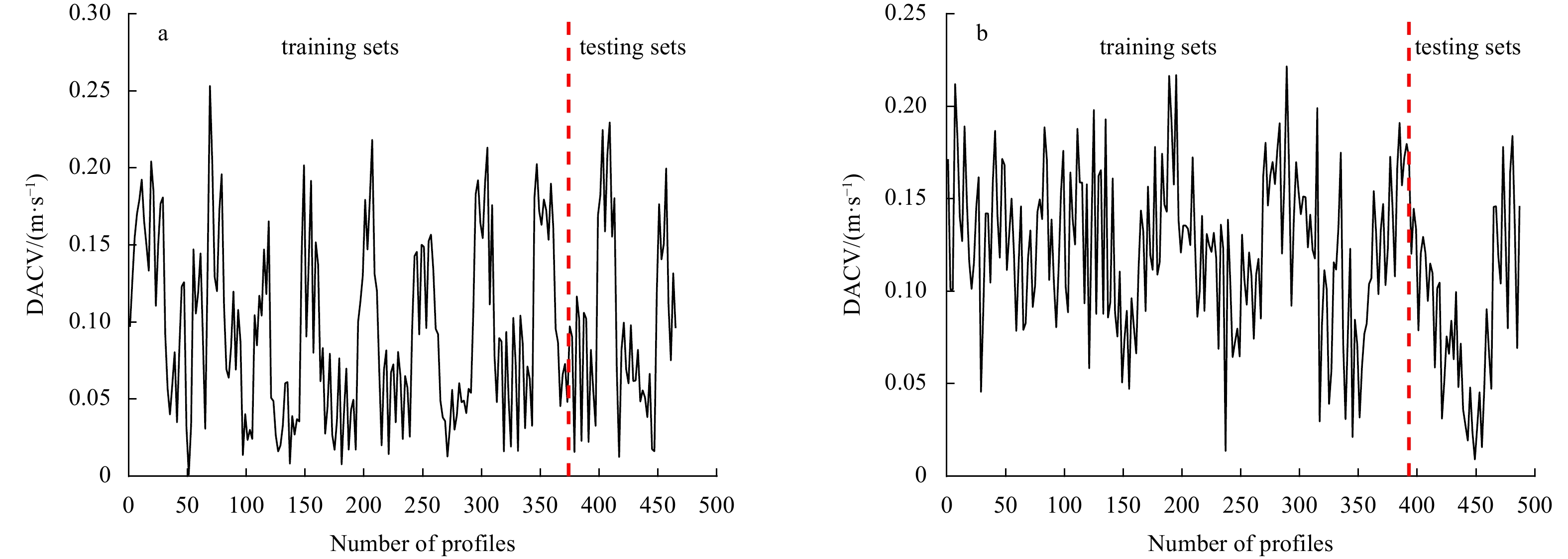
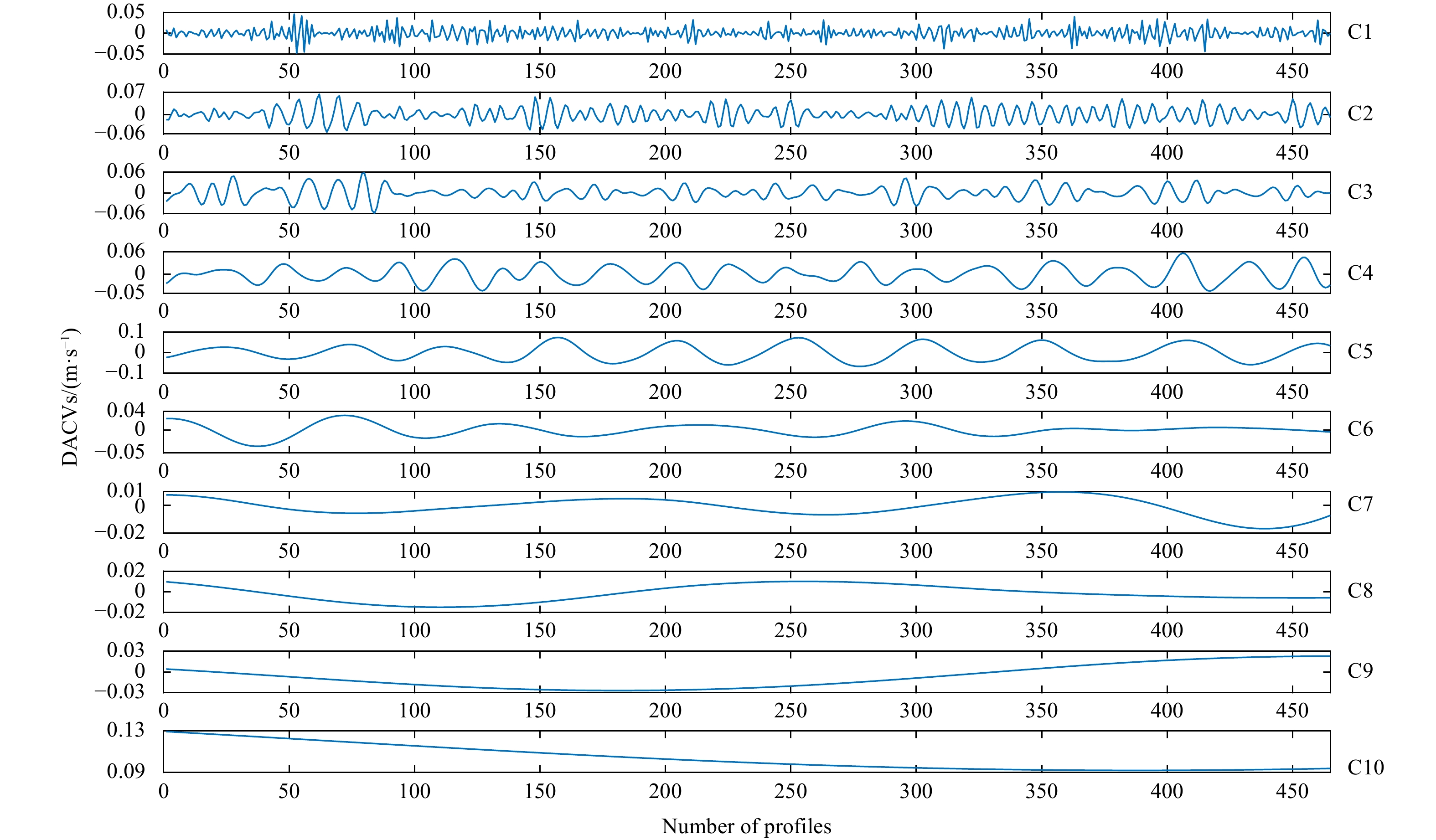
Abstract:
In this paper, we propose a hybrid forecasting model to improve the forecasting accuracy for depth-averaged current velocities (DACVs) of underwater gliders. The hybrid model is based on a discrete wavelet transform (DWT), a deep belief network (DBN), and a least squares support vector machine (LSSVM). The original DACV series are first decomposed into several high- and one low-frequency subseries by DWT. Then, DBN is used for high-frequency component forecasting, and the LSSVM model is adopted for low-frequency subseries. The effectiveness of the proposed model is verified by two groups of DACV data from sea trials in the South China Sea. Based on four general error criteria, the forecast performance of the proposed model is demonstrated. The comparison models include some well-recognized single models and some related hybrid models. The performance of the proposed model outperformed those of the other methods indicated above.
Reclamation-oriented spatiotemporal evolution of coastal wetland along Bohai Rim, China
Fan Wei, Mei Han, Guangxuan Han, Min Wang, Lixin Tian, Jiqian Zhu, Xianglun Kong
2022, 41(9): 192-204. doi: 10.1007/s13131-022-1987-3
Abstract:
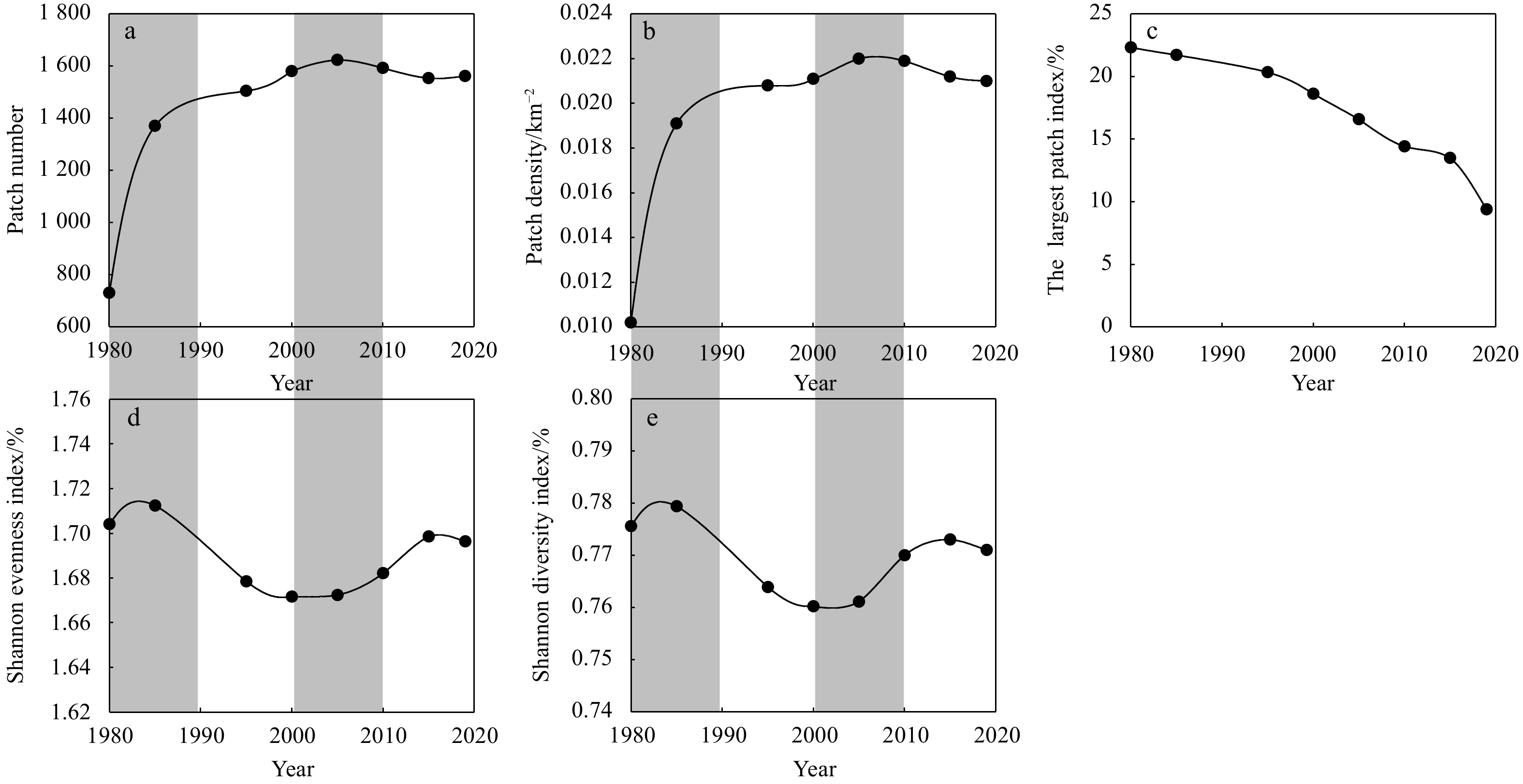
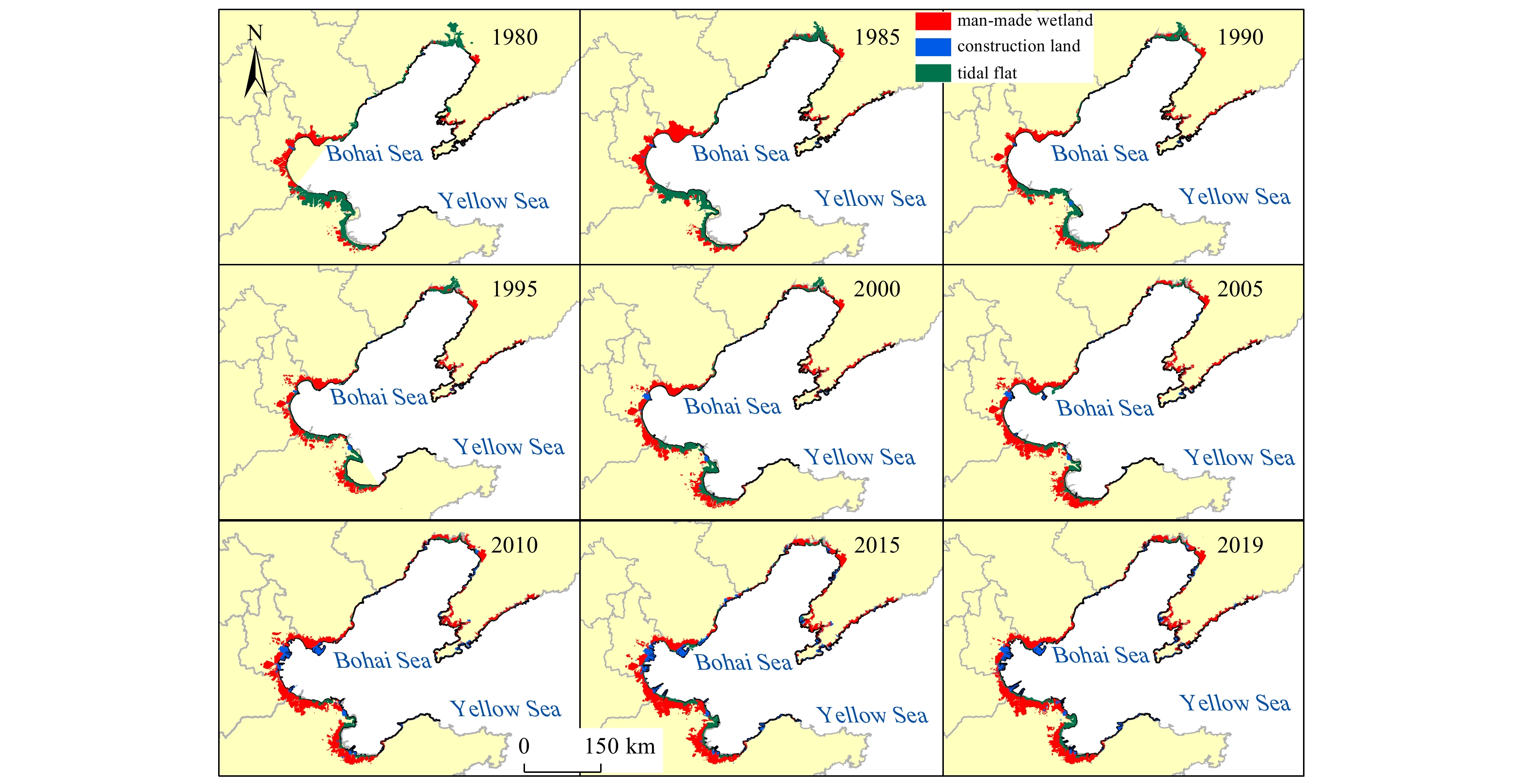
Coastal wetlands are located in the ecotone of interaction between the land surface and sea, and anthropogenic activities extensively interfere with these wetlands through the reclamation of large tidal wetlands and destruction of the function of the ecosystems. In this study, we investigated the dynamic evolutionary characteristics of the Bohai Rim coastal area over the past 40 years using the Modified Normalized Difference Water Index, the fractal dimension, object-oriented classification, the land-use transfer trajectory, and regression analysis. Additionally, we quantified and monitored the evolution of reclamation and analyzed the correlation between reclamation and coastal wetlands based on 99 Landsat-2, -5, and -8 images (at 60 m and 30 m spatial resolution) over the period 1980–2019. The results are as follows. (1) The coastline of the Bohai Rim increased by 1 631.2 km from 1980 to 2019 with a zigzag variation. The artificial coastline increased by 2 946.1 km, whereas the natural coastline decreased by 90%. (2) The area of man-made wetlands increased by 3 736.9 km2, the area of construction land increased by 1 008.4 km2, and the natural wetland area decreased by 66%. The decrease of tidal flats is the main contributor to the decrease of natural wetland area (takes account for 91.1%). Coastal areas are affected by intense human disturbance, which was taken place across a large area of tidal flats and caused the landscape to fragment and be more heterogeneous. The coastal zone development activities were primarily concentrated in the southern Laizhou Bay, the Yellow River Delta, the Bohai Bay, the northern Liaodong Bay, and the Pulandian Bay. The solidified shorelines and increase in sea level have resulted in intertidal wetlands decreasing and impaired wetland ecology. (3) There is a good agreement between reclamation and the size of the coastal wetlands. Both land reclamation and the reduction in coastal wetland areas are significantly related to the population size, fishery output value, and urbanization rate. In summary, human activities, such as the construction of aquaculture ponds and salt pans, industrialization, and urbanization, are the primary forces that influence the environmental changes in the coastal region. This study is beneficial for establishing and improving the systems for the rational development and utilization of natural resources, and provides theoretical references for restoring wetland ecology and managing future reclamation activities in other coastal zone-related areas.