2022 Vol. 41, No. 11
Display Method:
2022, 41(11): 1-11.
doi: 10.1007/s13131-021-1945-5
Abstract:
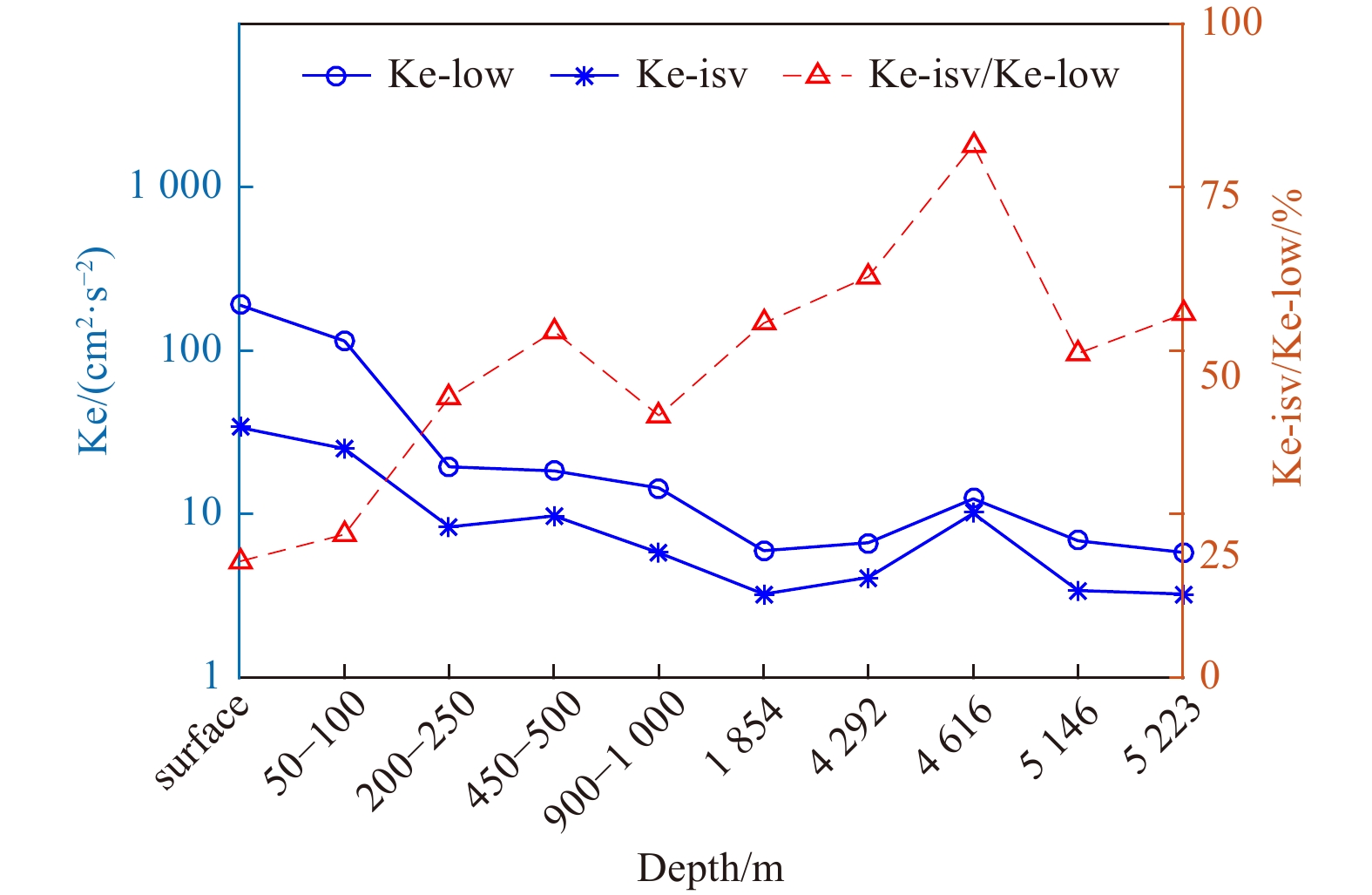
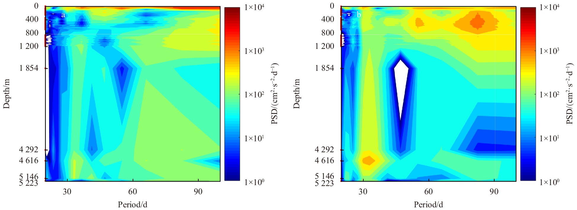
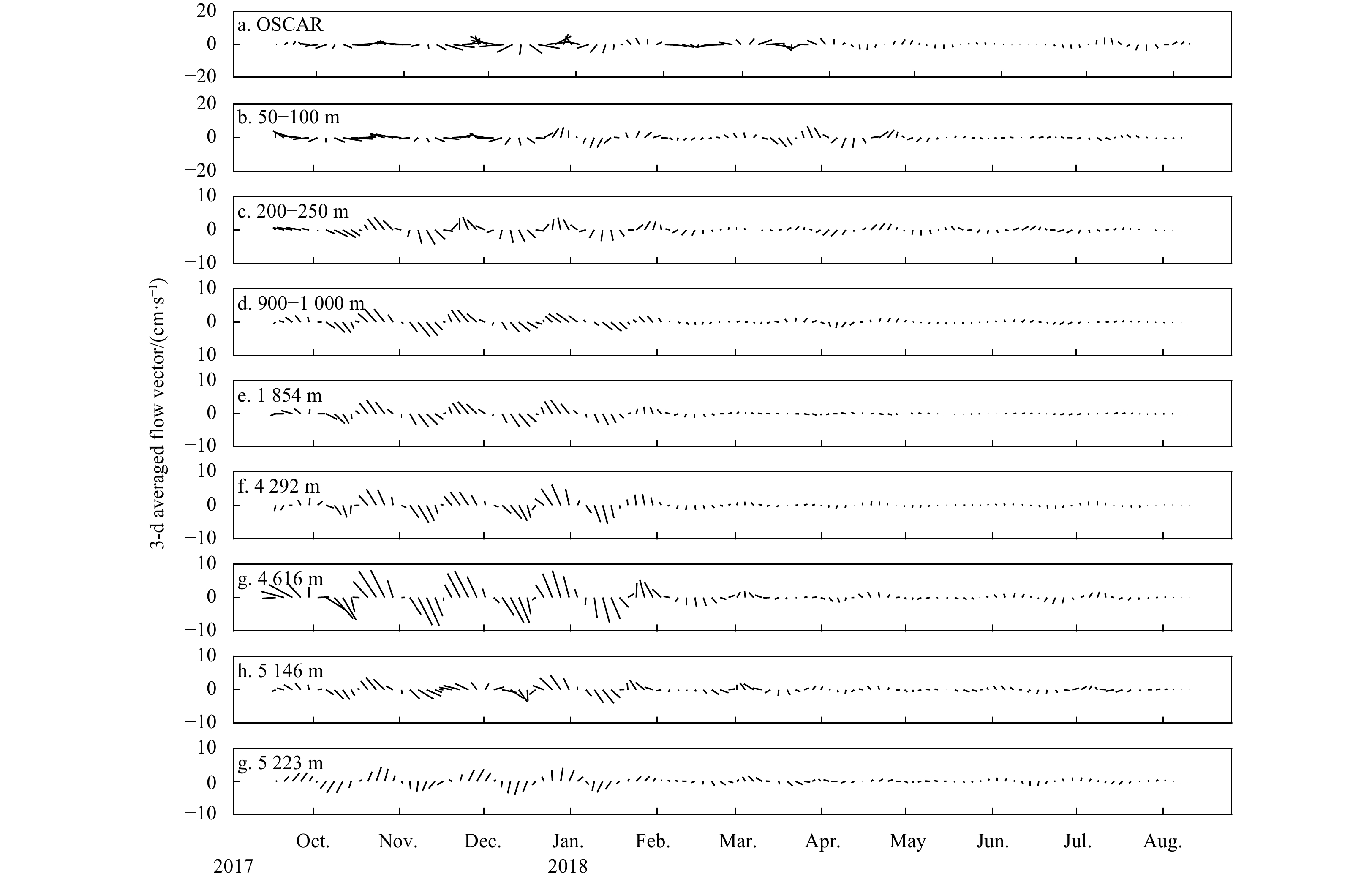
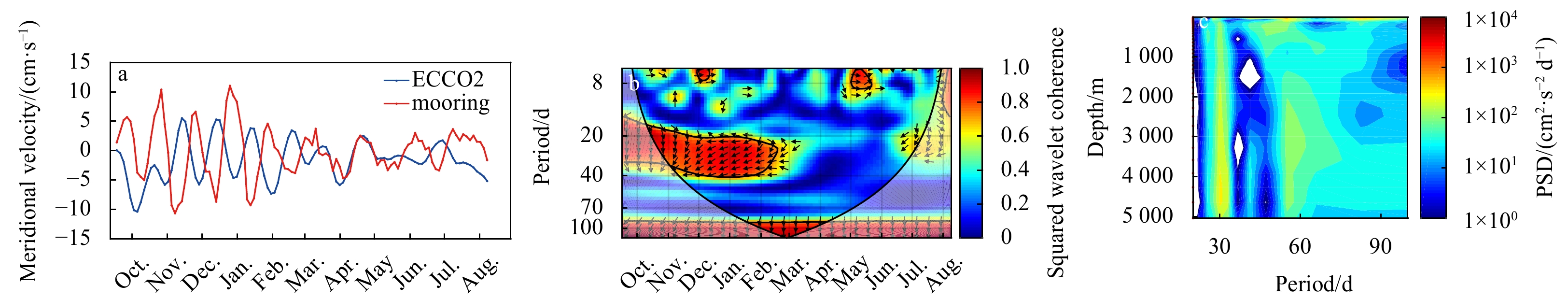
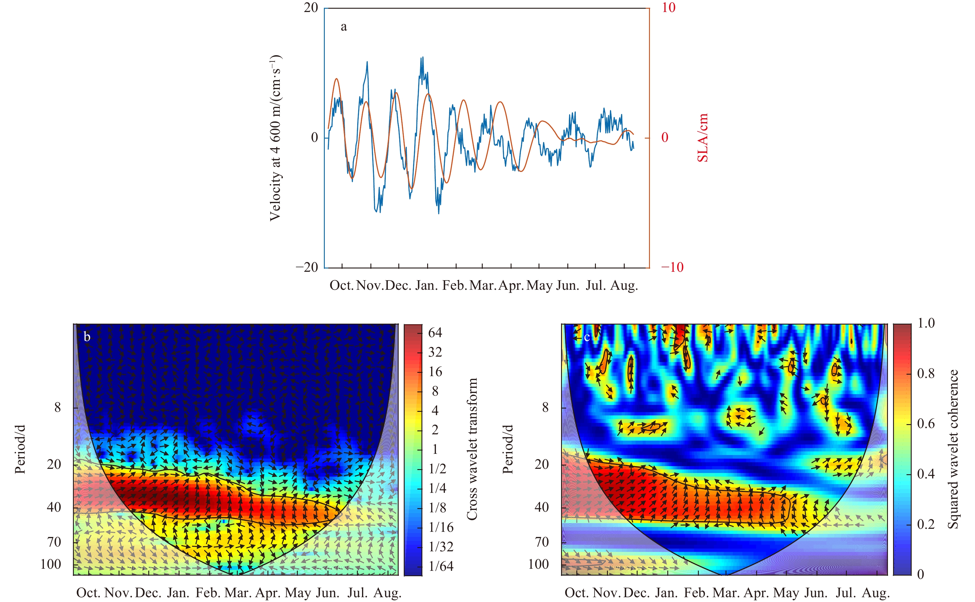
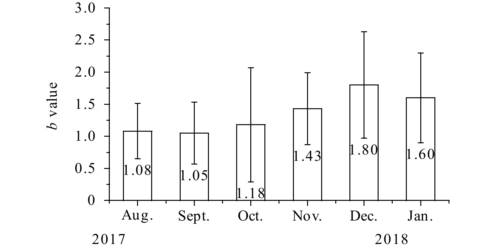
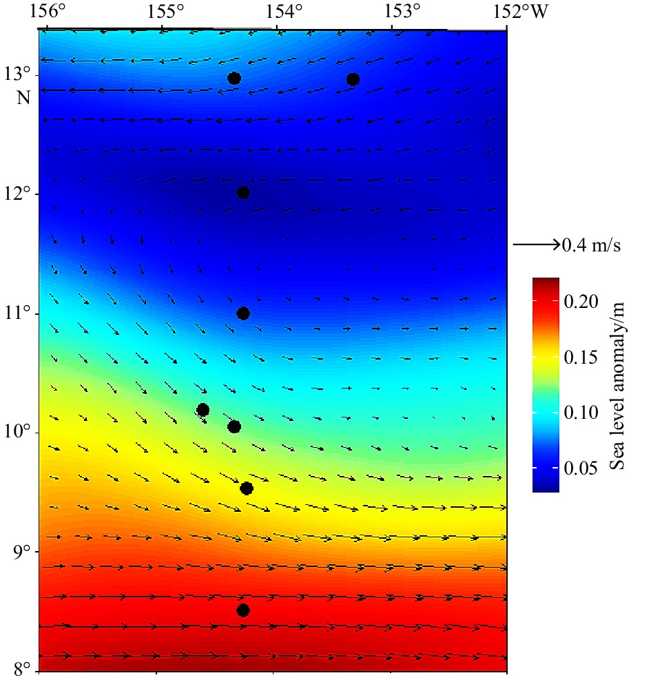
In this paper, the intra-seasonal variability of the abyssal currents in the China Ocean Mineral Resources Association (COMRA) polymetallic nodule contact area, located in the western part of the Clarion and Clipperton Fraction Zone in the tropical East Pacific, is investigated using direct observations from subsurface mooring instruments as well as sea-surface height data and reanalysis products. Mooring observations were conducted from September 13, 2017 to August 15, 2018 in the COMRA contact area (10°N, 154°W). The results were as follows: (1) At depths below 200 m, the kinetic energy of intra-seasonal variability (20−100 d) accounts for more than 40% of the overall low-frequency variability, while the ratio reaches more than 50% below 2 000 m. (2) At depths below 200 m, currents show a synchronous oscillation with a characteristic time scale of 30 d, lasting from October to the following January; the energy of the 30-d oscillation increases with depth until the layer of approximately 4 616 m, and the maximum velocity is approximately 10 cm/s. (3) The 30-d oscillation of deep currents is correlated with the tropical instability waves in the upper ocean.
In this paper, the intra-seasonal variability of the abyssal currents in the China Ocean Mineral Resources Association (COMRA) polymetallic nodule contact area, located in the western part of the Clarion and Clipperton Fraction Zone in the tropical East Pacific, is investigated using direct observations from subsurface mooring instruments as well as sea-surface height data and reanalysis products. Mooring observations were conducted from September 13, 2017 to August 15, 2018 in the COMRA contact area (10°N, 154°W). The results were as follows: (1) At depths below 200 m, the kinetic energy of intra-seasonal variability (20−100 d) accounts for more than 40% of the overall low-frequency variability, while the ratio reaches more than 50% below 2 000 m. (2) At depths below 200 m, currents show a synchronous oscillation with a characteristic time scale of 30 d, lasting from October to the following January; the energy of the 30-d oscillation increases with depth until the layer of approximately 4 616 m, and the maximum velocity is approximately 10 cm/s. (3) The 30-d oscillation of deep currents is correlated with the tropical instability waves in the upper ocean.


2022, 41(11): 12-22.
doi: 10.1007/s13131-021-1908-x
Abstract:
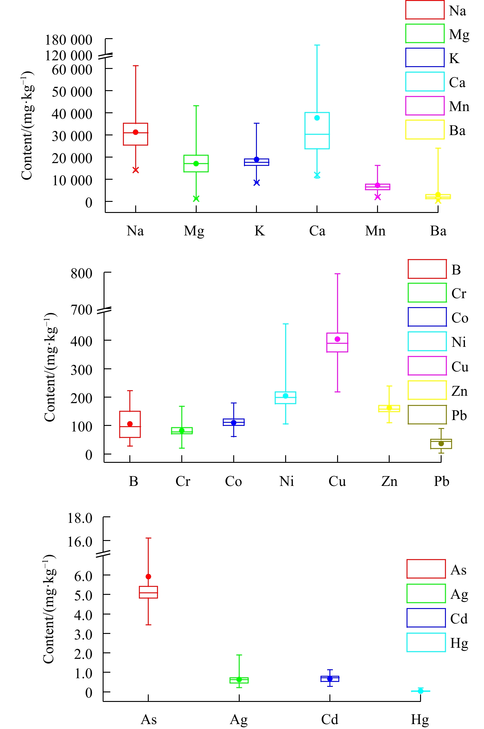
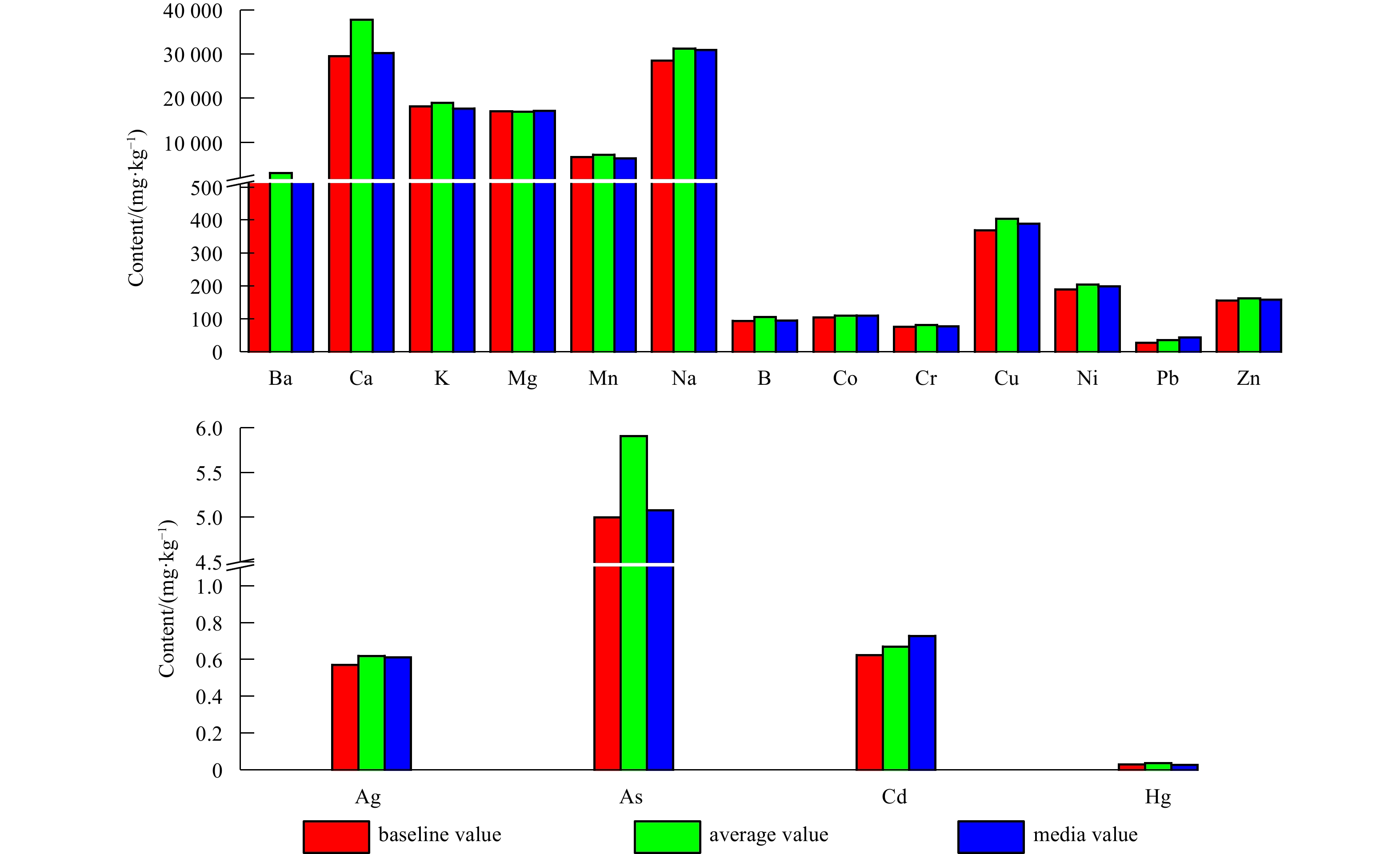
Resource exploitation in the Clarion-Clipperton Zone (CCZ) is of major research interest worldwide, but its influence on the environment is poorly understood, especially due to the lack of baseline values for metals in the surrounding sediment. This work aimed to establish the baseline values of 17 metals (Ba, Ca, K, Mg, Mn, Na, Ag, As, B, Cd, Co, Cr, Cu, Hg, Ni, Pb, and Zn) using normalization, the cumulative frequency curve method considering a total of 172 samples taken from 8 multitube cores and 1 box sediment core collected in the western CCZ during the COMRA-45 cruise campaign from August to September 2017. The baseline values of the evaluated metals were as follows: 1 932 mg/kg for Ba, 29 512 mg/kg for Ca, 18 150 mg/kg for K, 17 120 mg/kg for Mg, 6 747 mg/kg for Mn, 28 546 mg/kg for Na, 0.571 mg/kg for Ag, 5.00 mg/kg for As, 94.4 mg/kg for B, 0.626 mg/kg for Cd, 104 mg/kg for Co, 76.1 mg/kg for Cr, 370 mg/kg for Cu, 0.028 mg/kg for Hg, 190 mg/kg for Ni, 27.5 mg/kg for Pb and 156 mg/kg for Zn. Our findings would fill the baseline value gap in the study area and further improve accuracy of environmental impact assessments on the impact of resource exploitation.
Resource exploitation in the Clarion-Clipperton Zone (CCZ) is of major research interest worldwide, but its influence on the environment is poorly understood, especially due to the lack of baseline values for metals in the surrounding sediment. This work aimed to establish the baseline values of 17 metals (Ba, Ca, K, Mg, Mn, Na, Ag, As, B, Cd, Co, Cr, Cu, Hg, Ni, Pb, and Zn) using normalization, the cumulative frequency curve method considering a total of 172 samples taken from 8 multitube cores and 1 box sediment core collected in the western CCZ during the COMRA-45 cruise campaign from August to September 2017. The baseline values of the evaluated metals were as follows: 1 932 mg/kg for Ba, 29 512 mg/kg for Ca, 18 150 mg/kg for K, 17 120 mg/kg for Mg, 6 747 mg/kg for Mn, 28 546 mg/kg for Na, 0.571 mg/kg for Ag, 5.00 mg/kg for As, 94.4 mg/kg for B, 0.626 mg/kg for Cd, 104 mg/kg for Co, 76.1 mg/kg for Cr, 370 mg/kg for Cu, 0.028 mg/kg for Hg, 190 mg/kg for Ni, 27.5 mg/kg for Pb and 156 mg/kg for Zn. Our findings would fill the baseline value gap in the study area and further improve accuracy of environmental impact assessments on the impact of resource exploitation.


2022, 41(11): 23-33.
doi: 10.1007/s13131-021-1918-8
Abstract:
Based upon cruise observations broadly covering the tropical North Pacific during July−November 2017, together with data obtained from the World Ocean Circulation Experiment Hydrographic Program, this study examined the distribution of dissolved inorganic nitrogen (DIN, nitrate (\begin{document}${{\rm {NO}}_3^-} $\end{document} ![]()
![]()
\begin{document}${{\rm {NO}}_2^-} $\end{document} ![]()
![]()
Based upon cruise observations broadly covering the tropical North Pacific during July−November 2017, together with data obtained from the World Ocean Circulation Experiment Hydrographic Program, this study examined the distribution of dissolved inorganic nitrogen (DIN, nitrate (


2022, 41(11): 34-44.
doi: 10.1007/s13131-022-2106-1
Abstract:
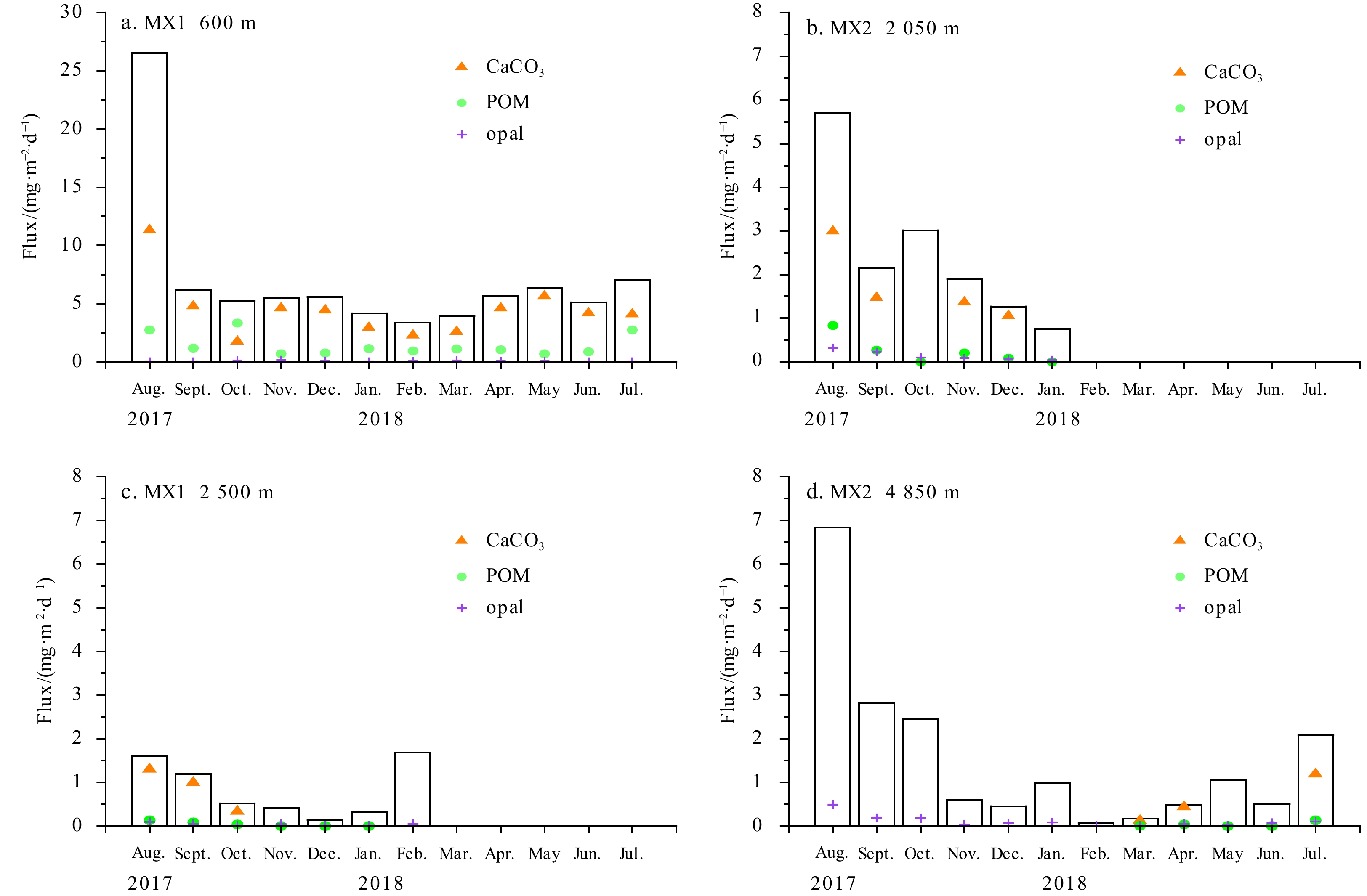
The flux of settling particles in the ocean has been widely explored since 1980s due to its important role in biogenic elements cycling, especially in the transport of particulate organic carbon (POC) in the deep sea. However, research in the seamount area of the oligotrophic subtropical Northwest Pacific Ocean is lacking. In this work, two sediment traps were deployed at the foot and another two at the hillside of Niulang Guyot from August 2017 to July 2018. The magnitude and composition of particle fluxes were measured. The main factors influencing the spatial variations of the fluxes were evaluated. Our results indicated a low particulate flux from Niulang Guyot area in the Northwest Pacific Ocean, reflecting low primary productivity of the oligotrophic ocean. The total mass flux (TMF) decreased from 2.57 g/(m2·a) to 0.56 g/(m2·a) with increasing depth from 600 m to 4 850 m. A clear seasonal pattern of TMF was observed, with higher flux in summer than that in winter. The peak flux of 26.52 mg/(m2·d) occurred in August at 600 m, while the lowest value of 0.07 mg/(m2·d) was shown in February at 4 850 m. The settling particles at the deep layers had similar biochemical composition, with calcium carbonate (CaCO3) accounting for up to 90%, followed by organic matter and opal, characteristics of Carbonate Ocean. The POC flux decreased more rapidly in the twilight layer because of faster decomposition, remineralization, and higher temperature. A small fraction of POC was transported into the deep ocean by biological pump. Particle fluxes were mainly controlled by the calcareous ballasts besides the primary productivity of the surface water. The advection may be another important factor affecting the flux in the seamount area. The combination of settled matters rich in foraminiferal tests with topography and currents may be the reason for regulating the local abundance of benthos on seamounts. Our results will fill in the knowledge gap of sedimentation flux, improve the understanding of ecosystem in Niulang Guyot area, and eventually provide data support for the optimization of regional ecological modeling.
The flux of settling particles in the ocean has been widely explored since 1980s due to its important role in biogenic elements cycling, especially in the transport of particulate organic carbon (POC) in the deep sea. However, research in the seamount area of the oligotrophic subtropical Northwest Pacific Ocean is lacking. In this work, two sediment traps were deployed at the foot and another two at the hillside of Niulang Guyot from August 2017 to July 2018. The magnitude and composition of particle fluxes were measured. The main factors influencing the spatial variations of the fluxes were evaluated. Our results indicated a low particulate flux from Niulang Guyot area in the Northwest Pacific Ocean, reflecting low primary productivity of the oligotrophic ocean. The total mass flux (TMF) decreased from 2.57 g/(m2·a) to 0.56 g/(m2·a) with increasing depth from 600 m to 4 850 m. A clear seasonal pattern of TMF was observed, with higher flux in summer than that in winter. The peak flux of 26.52 mg/(m2·d) occurred in August at 600 m, while the lowest value of 0.07 mg/(m2·d) was shown in February at 4 850 m. The settling particles at the deep layers had similar biochemical composition, with calcium carbonate (CaCO3) accounting for up to 90%, followed by organic matter and opal, characteristics of Carbonate Ocean. The POC flux decreased more rapidly in the twilight layer because of faster decomposition, remineralization, and higher temperature. A small fraction of POC was transported into the deep ocean by biological pump. Particle fluxes were mainly controlled by the calcareous ballasts besides the primary productivity of the surface water. The advection may be another important factor affecting the flux in the seamount area. The combination of settled matters rich in foraminiferal tests with topography and currents may be the reason for regulating the local abundance of benthos on seamounts. Our results will fill in the knowledge gap of sedimentation flux, improve the understanding of ecosystem in Niulang Guyot area, and eventually provide data support for the optimization of regional ecological modeling.


2022, 41(11): 45-57.
doi: 10.1007/s13131-021-1938-4
Abstract:
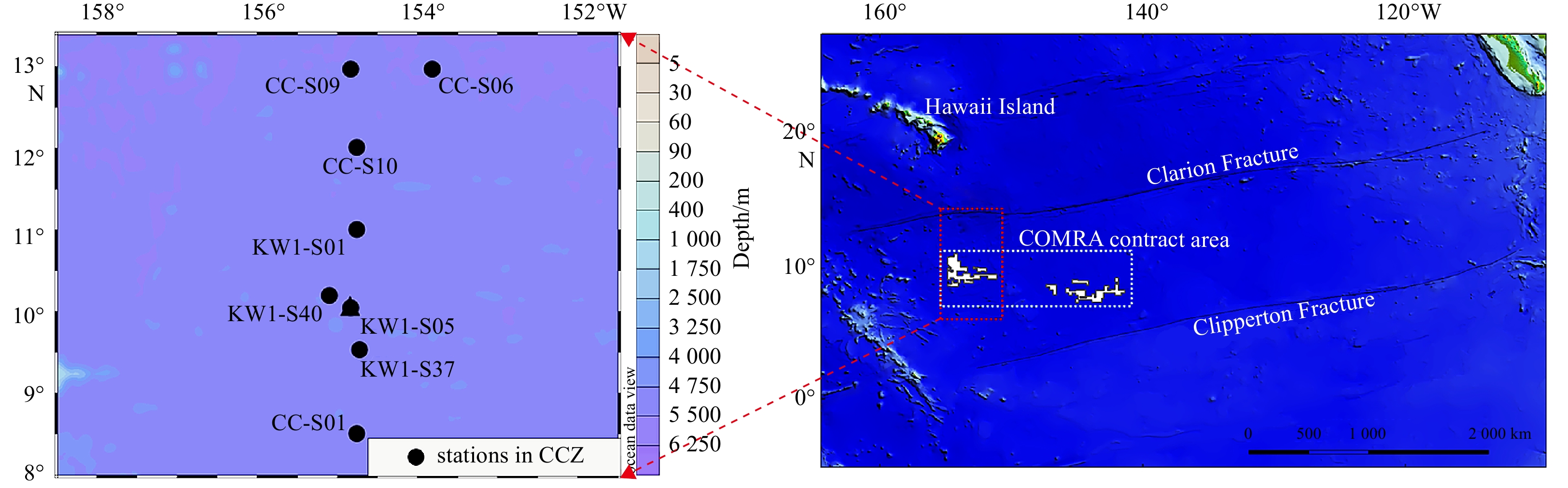
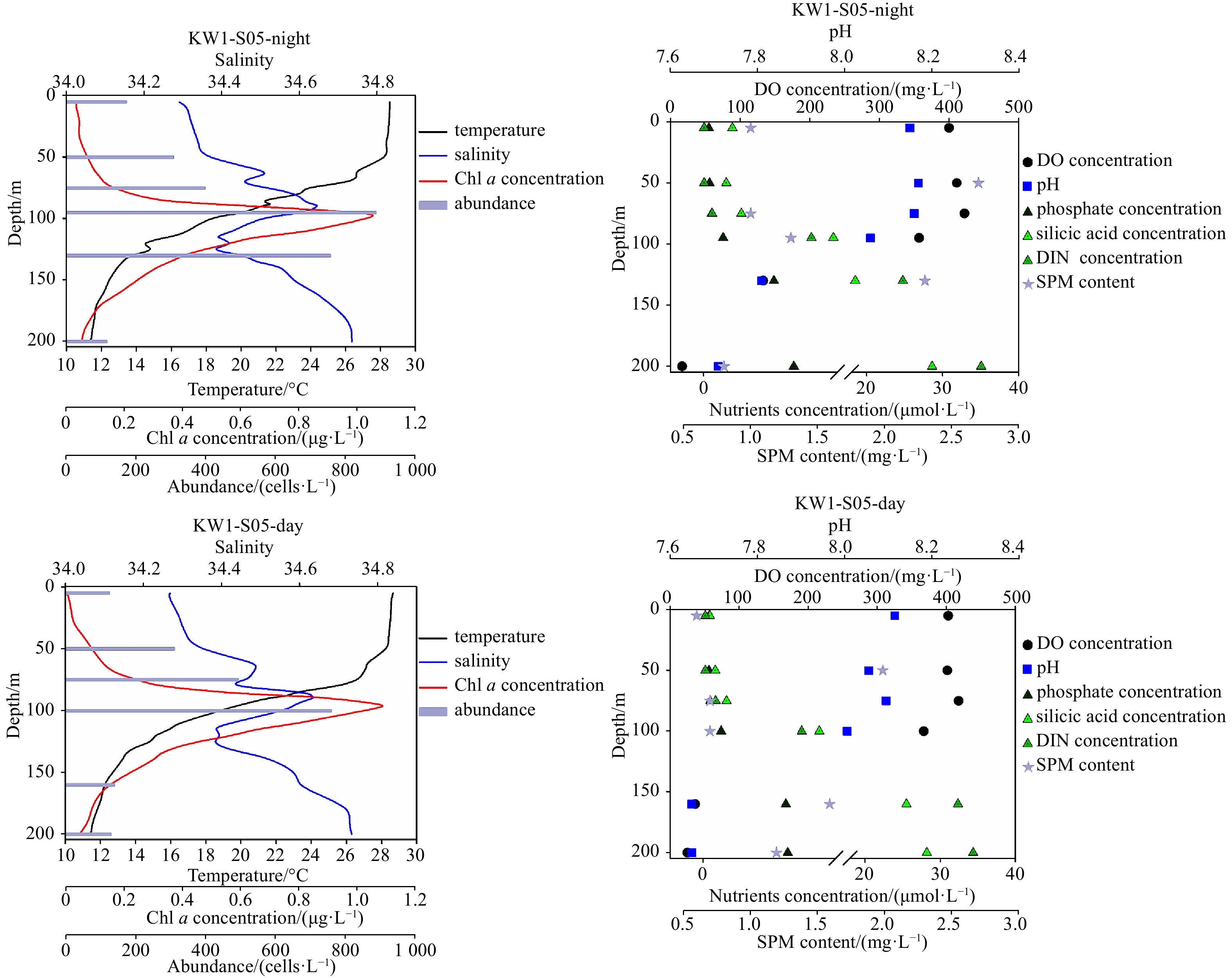
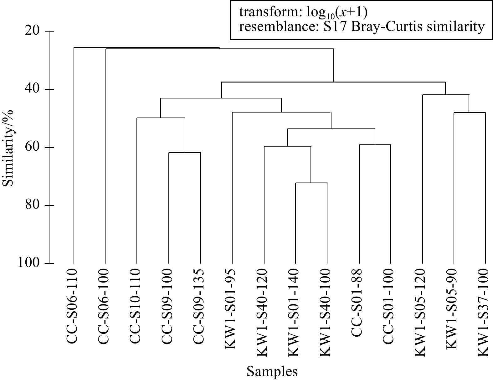
The Clarion-Clipperton Zone (CCZ) hosts one of the largest known oceanic nodule fields worldwide and is regulated by the International Seabed Authority. A baseline assessment of diversity and distribution patterns is essential for reliable predictions of disturbed ecosystem response scenarios for sustained commercial activities in the future. In the present study, the spatial patterns and diversity of phytoplankton communities were analyzed along with upper ocean biogeochemistry, in the licensed China Ocean Mineral Resources R&D Association (COMRA) contract area and the surrounding western CCZ between August 21 and October 8, 2017. Results indicated this was a typical low-nutrient low-chlorophyll a (Chl a) environment, characterized by low levels of phytoplankton abundance and diversity. In total 112 species belonging to 4 phyla were recorded (>10 μm), with species counts including 82 diatoms, 27 dinoflagellates, 1 cyanobacteria and 2 chrysophyte. Dominant taxa in successive order of descending abundance and occurrence included Nizschia marina, Cyclotella stylorum, Dactyliosolen mediterraneus, Rhizosolenia setigera, Pseudo-nitzschia delicatissima, Thalassiothrix frauenfeldii, Synedra sp., Chaetoceros simplex and Pseudo-nitzschia circumpora. The depth-averaged abundance and Chl a concentrations were (265±233) cells/L and (0.27±0.30) μg/L, respectively. Diatoms accounted for 90.94% of the community with (241±223) cells/L, while dinoflagellates accounted for 5.67% and (15±13) cells/L. The distribution pattern exhibited the same trend as abundance, Chl a and species richness, showing subsurface maximum levels at around 100 m, with stations near 10°N having higher levels than in the north. Cluster analysis was performed in two assemblages, relating to geographic locations to the south and north of 12°N. The subsurface maximum of abundance, Chl a, species richness, dissolved oxygen and nitrite were generally corresponding to the presence of high salinity North Pacific Central Water at depths of 50−120 m. Higher availability of nitrate, phosphate and silicic acid in the subsurface may account for the shift in phytoplankton distribution, as shown by redundancy correspondence and spearman correlation analysis. Diel variation in an anchor station demonstrated prominent species succession without significant differences in oceanographic variables, among which diatoms succession resulted from the light limitation, while dinoflagellate diel variation mainly related to lateral transport of water masses. The observed patchiness in spatial phytoplankton distributional patterns was attributed to upper ocean environmental gradients in the CCZ. The baseline generated in this study could be analyzed using current conservation strategy programs associated with deep-sea mining.
The Clarion-Clipperton Zone (CCZ) hosts one of the largest known oceanic nodule fields worldwide and is regulated by the International Seabed Authority. A baseline assessment of diversity and distribution patterns is essential for reliable predictions of disturbed ecosystem response scenarios for sustained commercial activities in the future. In the present study, the spatial patterns and diversity of phytoplankton communities were analyzed along with upper ocean biogeochemistry, in the licensed China Ocean Mineral Resources R&D Association (COMRA) contract area and the surrounding western CCZ between August 21 and October 8, 2017. Results indicated this was a typical low-nutrient low-chlorophyll a (Chl a) environment, characterized by low levels of phytoplankton abundance and diversity. In total 112 species belonging to 4 phyla were recorded (>10 μm), with species counts including 82 diatoms, 27 dinoflagellates, 1 cyanobacteria and 2 chrysophyte. Dominant taxa in successive order of descending abundance and occurrence included Nizschia marina, Cyclotella stylorum, Dactyliosolen mediterraneus, Rhizosolenia setigera, Pseudo-nitzschia delicatissima, Thalassiothrix frauenfeldii, Synedra sp., Chaetoceros simplex and Pseudo-nitzschia circumpora. The depth-averaged abundance and Chl a concentrations were (265±233) cells/L and (0.27±0.30) μg/L, respectively. Diatoms accounted for 90.94% of the community with (241±223) cells/L, while dinoflagellates accounted for 5.67% and (15±13) cells/L. The distribution pattern exhibited the same trend as abundance, Chl a and species richness, showing subsurface maximum levels at around 100 m, with stations near 10°N having higher levels than in the north. Cluster analysis was performed in two assemblages, relating to geographic locations to the south and north of 12°N. The subsurface maximum of abundance, Chl a, species richness, dissolved oxygen and nitrite were generally corresponding to the presence of high salinity North Pacific Central Water at depths of 50−120 m. Higher availability of nitrate, phosphate and silicic acid in the subsurface may account for the shift in phytoplankton distribution, as shown by redundancy correspondence and spearman correlation analysis. Diel variation in an anchor station demonstrated prominent species succession without significant differences in oceanographic variables, among which diatoms succession resulted from the light limitation, while dinoflagellate diel variation mainly related to lateral transport of water masses. The observed patchiness in spatial phytoplankton distributional patterns was attributed to upper ocean environmental gradients in the CCZ. The baseline generated in this study could be analyzed using current conservation strategy programs associated with deep-sea mining.


2022, 41(11): 58-72.
doi: 10.1007/s13131-021-1906-z
Abstract:
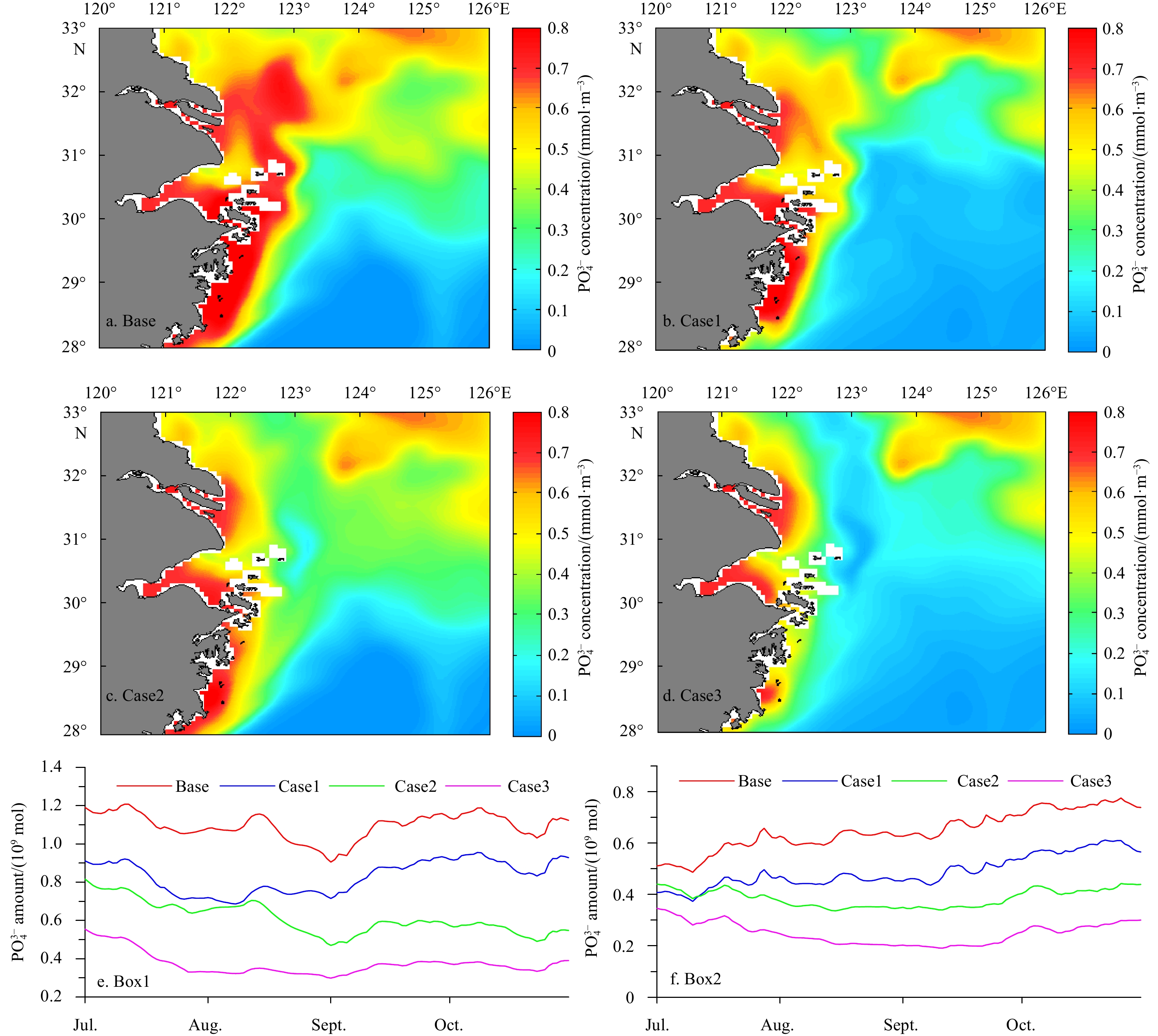
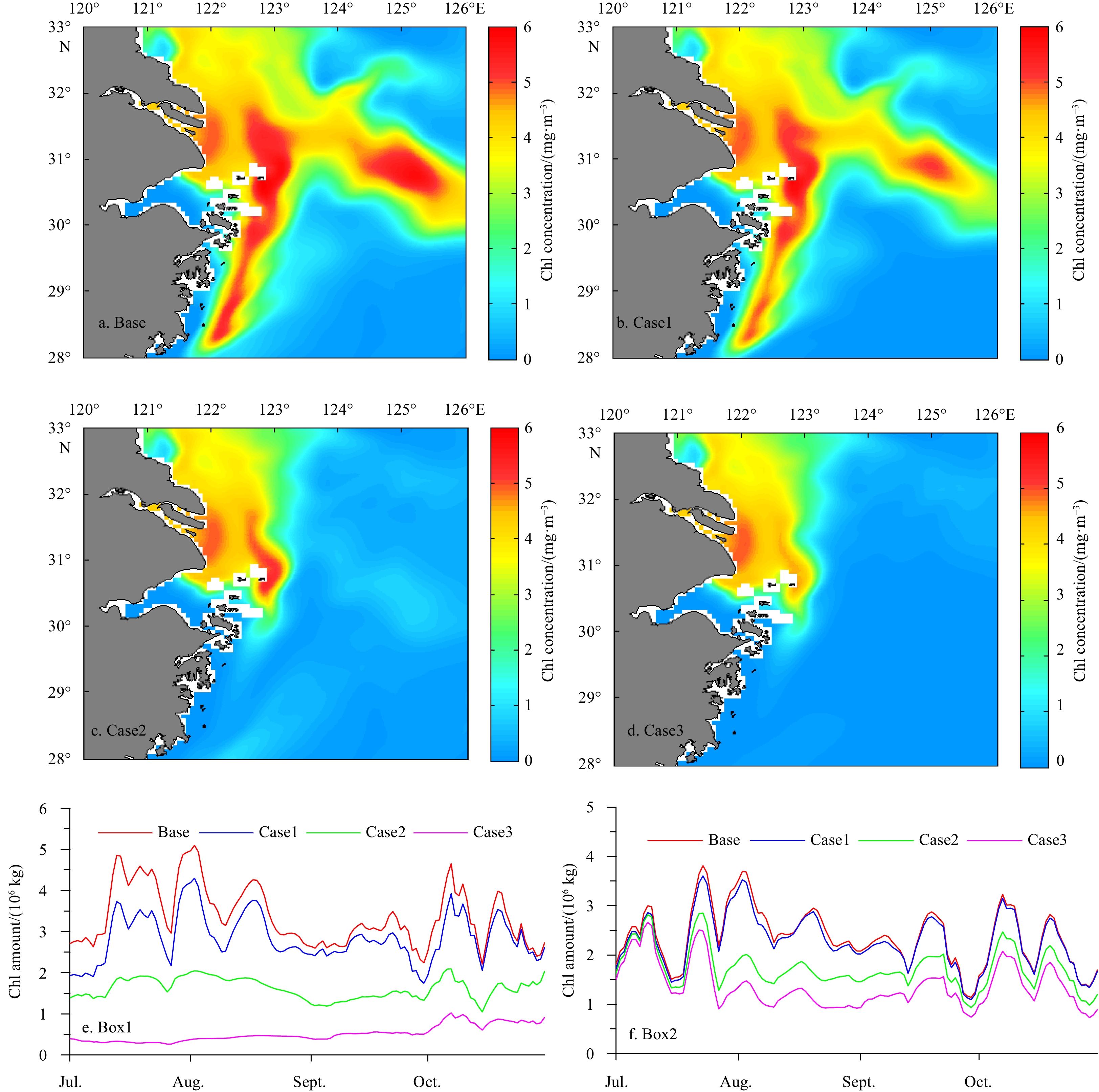
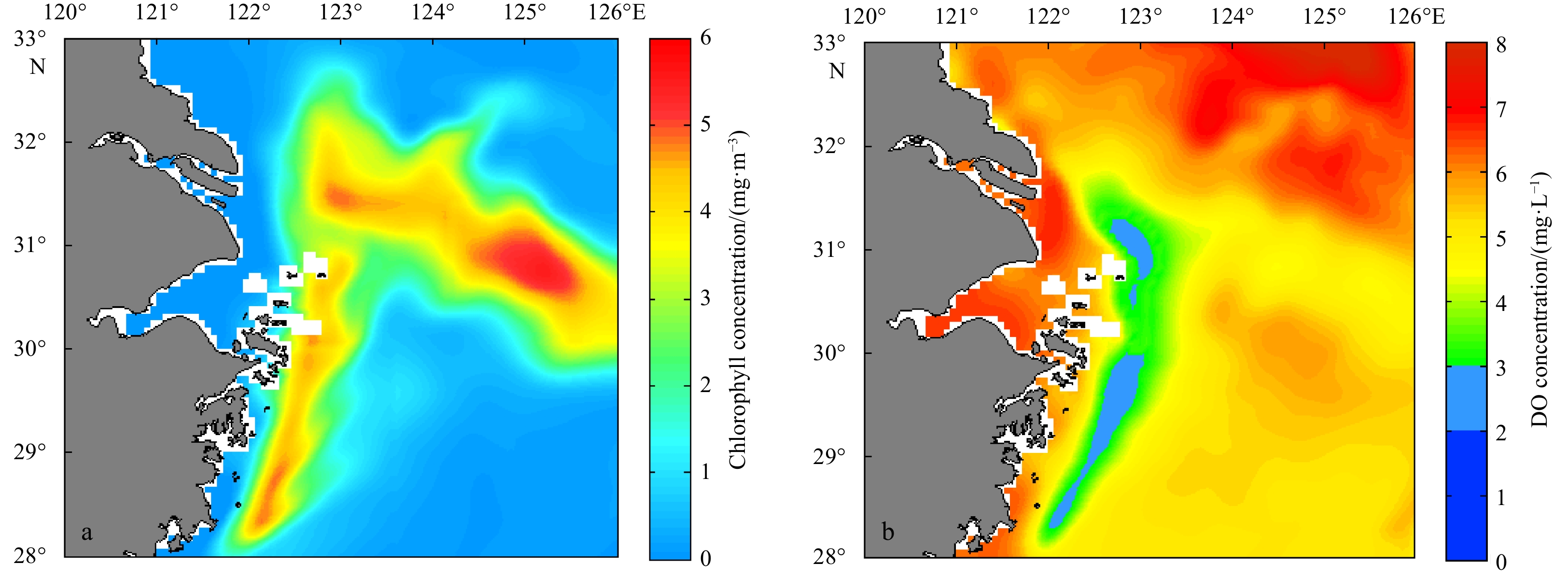
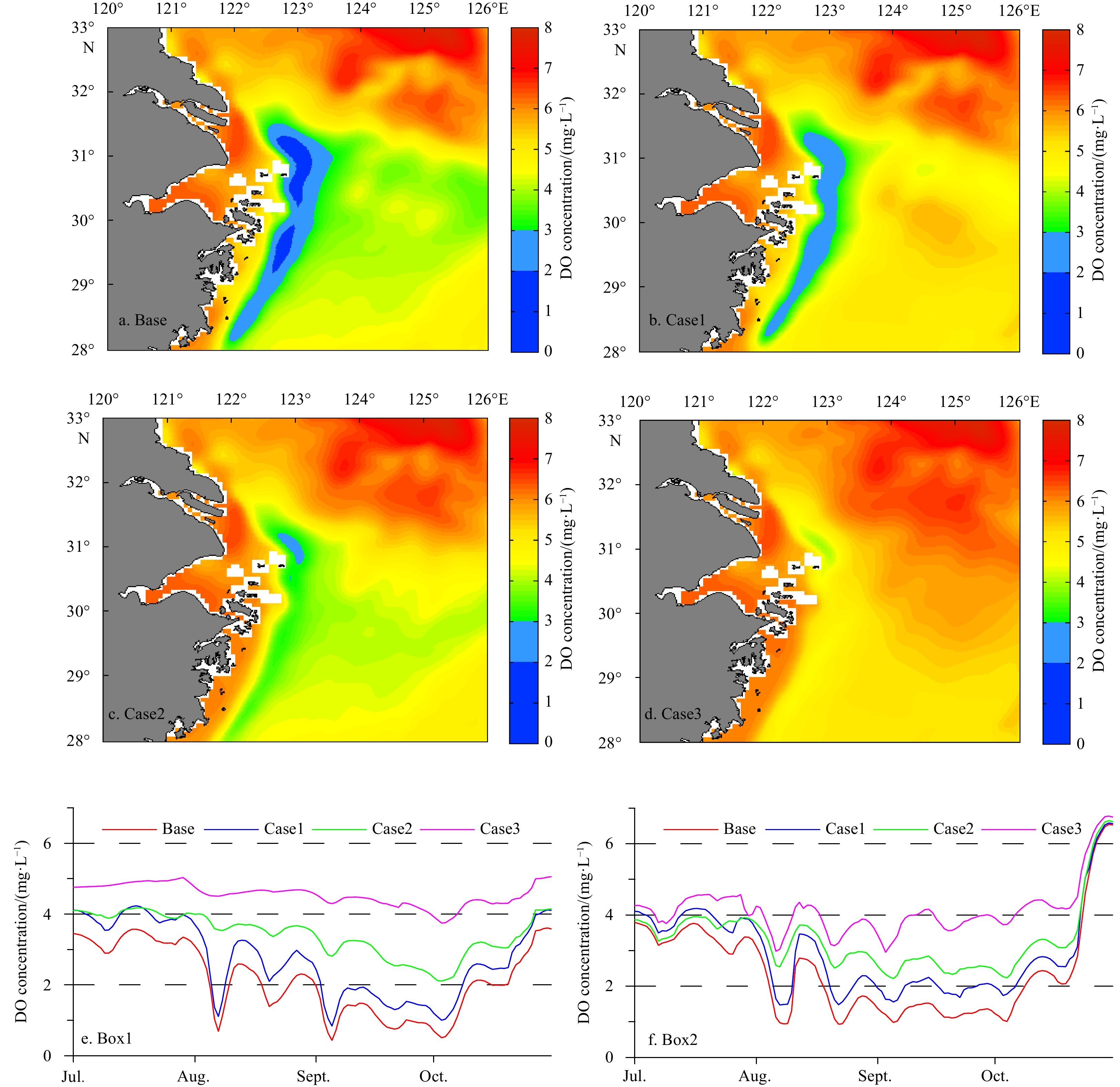
Hypoxia is increasingly reported off the Changjiang River Estuary with the confluence of multiple high volume nutrient sources. The Regional Ocean Modeling System coupled with a biological model was used to analyze the effect of different nutrient sources on the development of hypoxia off the Changjiang River Estuary. By comparing to observed data, our model suitably captured the regional dynamics of chlorophyll a, dissolved oxygen, and nutrient concentration. A series of sensitivity experiments were conducted to investigate the hypoxia response to the various nutrient sources, such as loading from the Changjiang River, Kuroshio and Taiwan Warm Current. Our model results indicated that nutrients from different sources significantly influenced the hypoxia off the Changjiang River Estuary, and it was mostly affected by nutrients sourced from the Kuroshio. The nutrients input from the Changjiang River had larger impacts on the hypoxia in the north of 30°N than that in the south of 30°N. The nutrients sourced from the Taiwan Strait had a least influence on the hypoxia off the Changjiang River Estuary.
Hypoxia is increasingly reported off the Changjiang River Estuary with the confluence of multiple high volume nutrient sources. The Regional Ocean Modeling System coupled with a biological model was used to analyze the effect of different nutrient sources on the development of hypoxia off the Changjiang River Estuary. By comparing to observed data, our model suitably captured the regional dynamics of chlorophyll a, dissolved oxygen, and nutrient concentration. A series of sensitivity experiments were conducted to investigate the hypoxia response to the various nutrient sources, such as loading from the Changjiang River, Kuroshio and Taiwan Warm Current. Our model results indicated that nutrients from different sources significantly influenced the hypoxia off the Changjiang River Estuary, and it was mostly affected by nutrients sourced from the Kuroshio. The nutrients input from the Changjiang River had larger impacts on the hypoxia in the north of 30°N than that in the south of 30°N. The nutrients sourced from the Taiwan Strait had a least influence on the hypoxia off the Changjiang River Estuary.


2022, 41(11): 73-80.
doi: 10.1007/s13131-022-2040-2
Abstract:
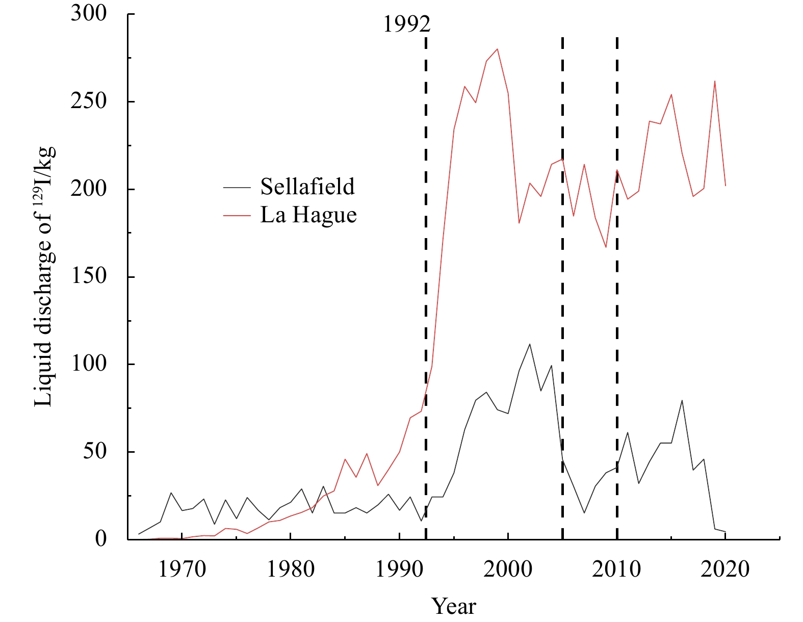
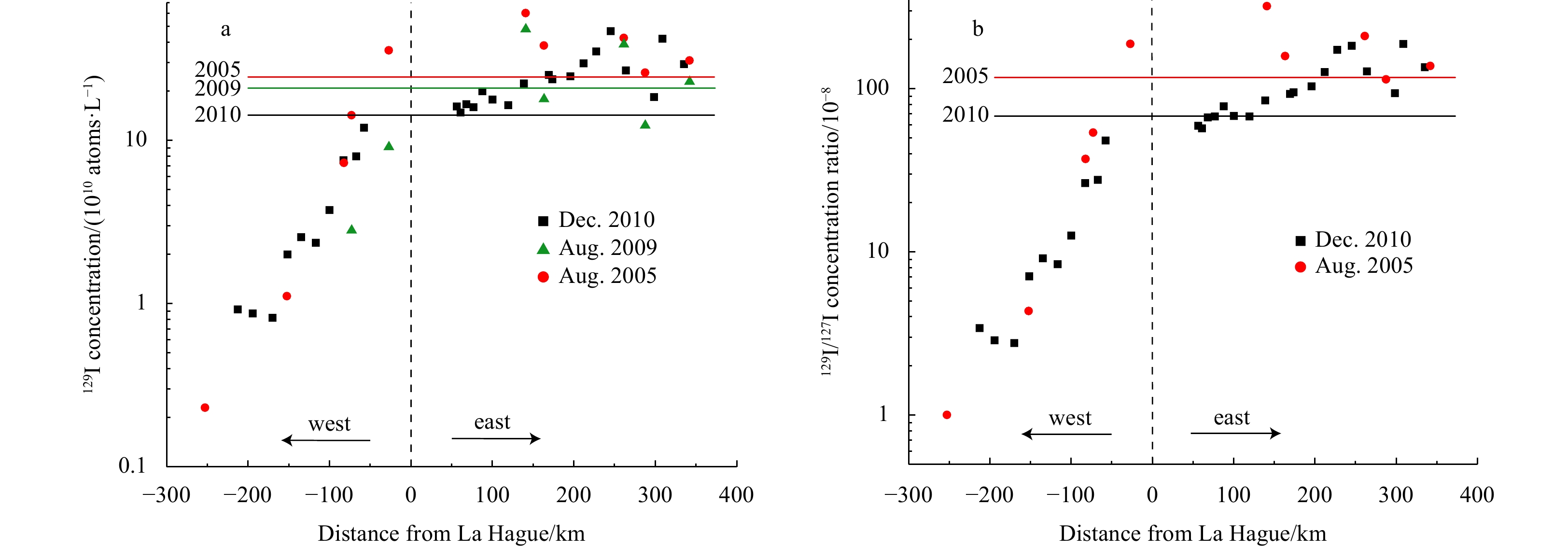
The English Channel (the Channel) represents a major sink and transport pathway of anthropogenic radioactive 129I. Despite this important role, data concerning the distribution of 129I in seawater of the Channel are scarce, and most of existing data are restricted to the eastern part of the Channel. The advection and dispersion of 129I from the French coast toward the central and further the English coast, especially in the Channel west of Cap de La Hague, are not fully investigated. We present results of iodine isotopes (127I and 129I) analyses of surface water samples collected along the central English Channel in October, 2010. The data show high 129I concentrations between Dover Strait and La Hague, followed by a dramatic drop towards the Celtic Sea and reveal the dispersal of 129I towards central and northern part of the Channel. Our observation also implies that the entire British coast is contaminated by 129I. 129I levels in the westernmost English Channel, close to the English coast, may reflect combined influences from La Hague and Sellafield. Evolution of 129I between 2005 and 2010 suggests a strong link to temporal marine discharges from La Hague plant. The discharges from the nuclear reprocessing facility have continued since 2010 and thus an ecological evaluation of 129I radioactive hazards in the environment of the Channel may be needed.
The English Channel (the Channel) represents a major sink and transport pathway of anthropogenic radioactive 129I. Despite this important role, data concerning the distribution of 129I in seawater of the Channel are scarce, and most of existing data are restricted to the eastern part of the Channel. The advection and dispersion of 129I from the French coast toward the central and further the English coast, especially in the Channel west of Cap de La Hague, are not fully investigated. We present results of iodine isotopes (127I and 129I) analyses of surface water samples collected along the central English Channel in October, 2010. The data show high 129I concentrations between Dover Strait and La Hague, followed by a dramatic drop towards the Celtic Sea and reveal the dispersal of 129I towards central and northern part of the Channel. Our observation also implies that the entire British coast is contaminated by 129I. 129I levels in the westernmost English Channel, close to the English coast, may reflect combined influences from La Hague and Sellafield. Evolution of 129I between 2005 and 2010 suggests a strong link to temporal marine discharges from La Hague plant. The discharges from the nuclear reprocessing facility have continued since 2010 and thus an ecological evaluation of 129I radioactive hazards in the environment of the Channel may be needed.


2022, 41(11): 81-87.
doi: 10.1007/s13131-022-2034-0
Abstract:
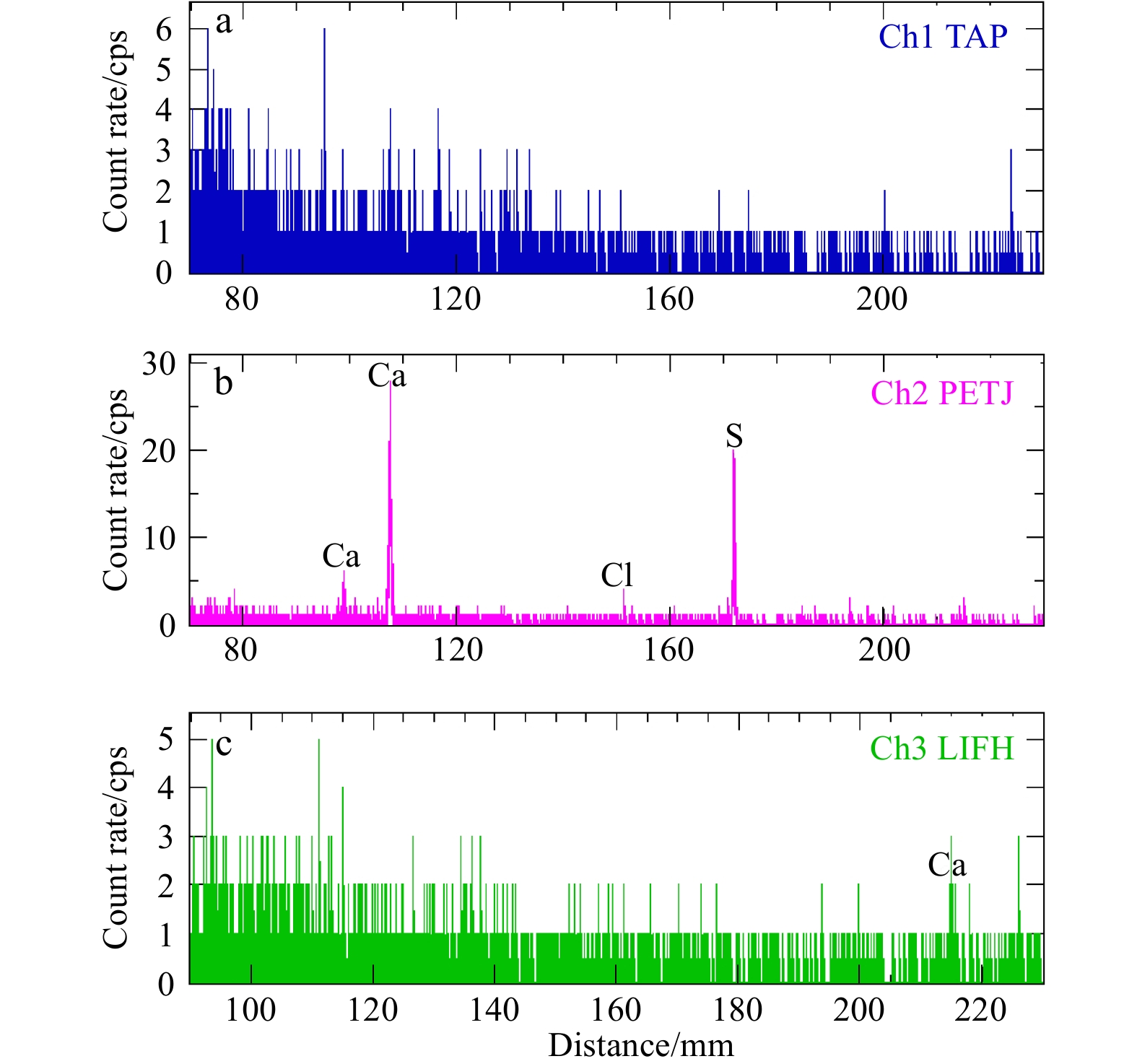
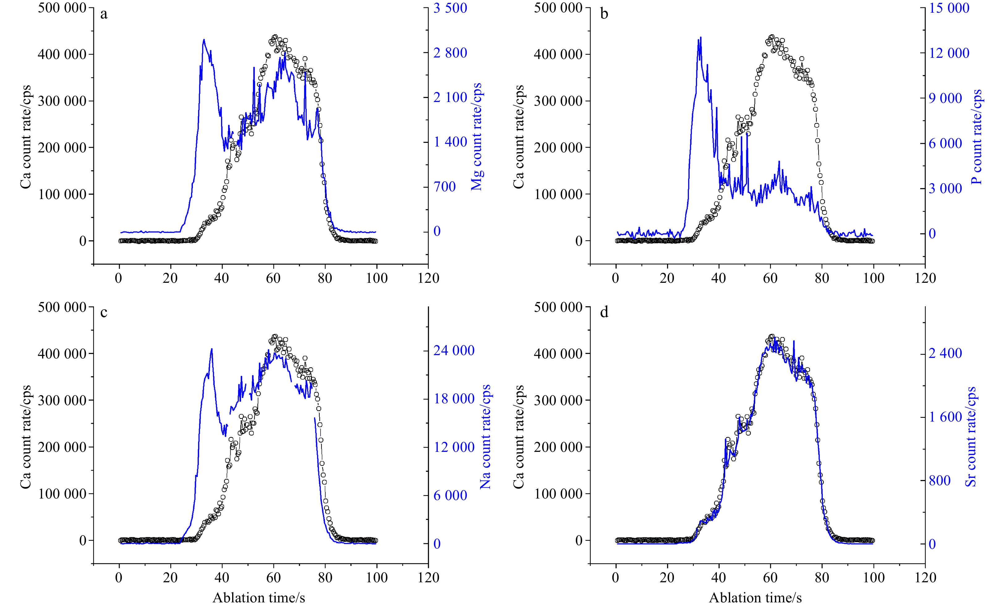
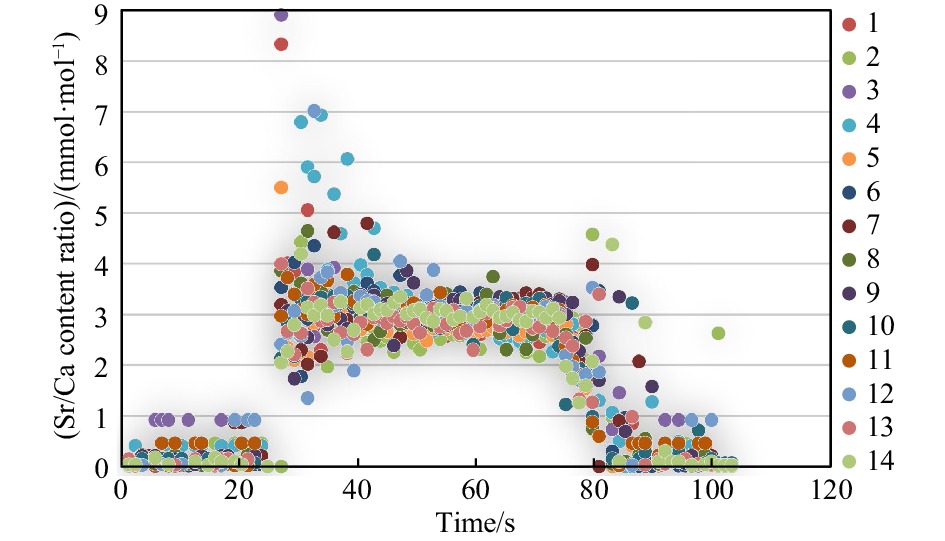
Scyphozoan jellyfish outbreak events are drawing increasing attentions during the past decade. Elemental compositions of statoliths are helpful to understand jellyfish life history and blooming mechanisms, but very rare endeavor has been focused on the Scyphozoan class. In this work, we explored the feasibility of element analysis of Aurelia aurita (a representative Scyphozoan jellyfish outbreak species in China) which may be used as proxies of environment parameters during jellyfish living and moving. Statolith crystals of Aurelia aurita were found to be a gathering of hexahedron type trigonal needle with size of 10−50 μm long, and 5−10 μm in diameter. By using laser ablation inductively coupled plasma mass spectrometry (LA-ICP-MS) downhole profiling method, elements such as Ca, Sr, Mg, Na and P were found to be above the limit of detection and limit of quantification. The epidermis of statocyst could significantly impact the element analyses, so the real statolith element signal section needs to be selected based on elements and Ca profiles together with care. By laser ablated a signal spot repeatedly, the analytical uncertainty was about 3%−4% for Sr/Ca content ratio and Mg/Ca content ratio, but above 10% for other element/Ca content ratios (n=3). Based on the analysis of statolith from temperature-control cultured jellyfish, Sr/Ca content ratios among different statoliths of the same jellyfish were about 6% (n=14), demonstrating biological processes/vital effects causing small variations compared with analytical uncertainties. Therefore, Sr/Ca content ratios may be used as a potential proxy to reveal the living environment variations the Scyphozoan jellyfish has experienced, such as temperature history, which is helpful to understand jellyfish bloom mechanisms.
Scyphozoan jellyfish outbreak events are drawing increasing attentions during the past decade. Elemental compositions of statoliths are helpful to understand jellyfish life history and blooming mechanisms, but very rare endeavor has been focused on the Scyphozoan class. In this work, we explored the feasibility of element analysis of Aurelia aurita (a representative Scyphozoan jellyfish outbreak species in China) which may be used as proxies of environment parameters during jellyfish living and moving. Statolith crystals of Aurelia aurita were found to be a gathering of hexahedron type trigonal needle with size of 10−50 μm long, and 5−10 μm in diameter. By using laser ablation inductively coupled plasma mass spectrometry (LA-ICP-MS) downhole profiling method, elements such as Ca, Sr, Mg, Na and P were found to be above the limit of detection and limit of quantification. The epidermis of statocyst could significantly impact the element analyses, so the real statolith element signal section needs to be selected based on elements and Ca profiles together with care. By laser ablated a signal spot repeatedly, the analytical uncertainty was about 3%−4% for Sr/Ca content ratio and Mg/Ca content ratio, but above 10% for other element/Ca content ratios (n=3). Based on the analysis of statolith from temperature-control cultured jellyfish, Sr/Ca content ratios among different statoliths of the same jellyfish were about 6% (n=14), demonstrating biological processes/vital effects causing small variations compared with analytical uncertainties. Therefore, Sr/Ca content ratios may be used as a potential proxy to reveal the living environment variations the Scyphozoan jellyfish has experienced, such as temperature history, which is helpful to understand jellyfish bloom mechanisms.


2022, 41(11): 88-95.
doi: 10.1007/s13131-022-2039-8
Abstract:
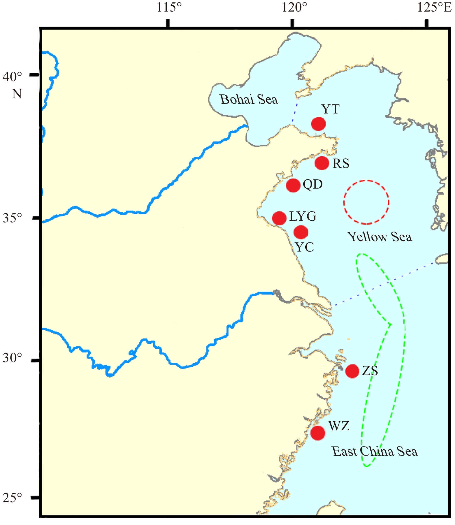
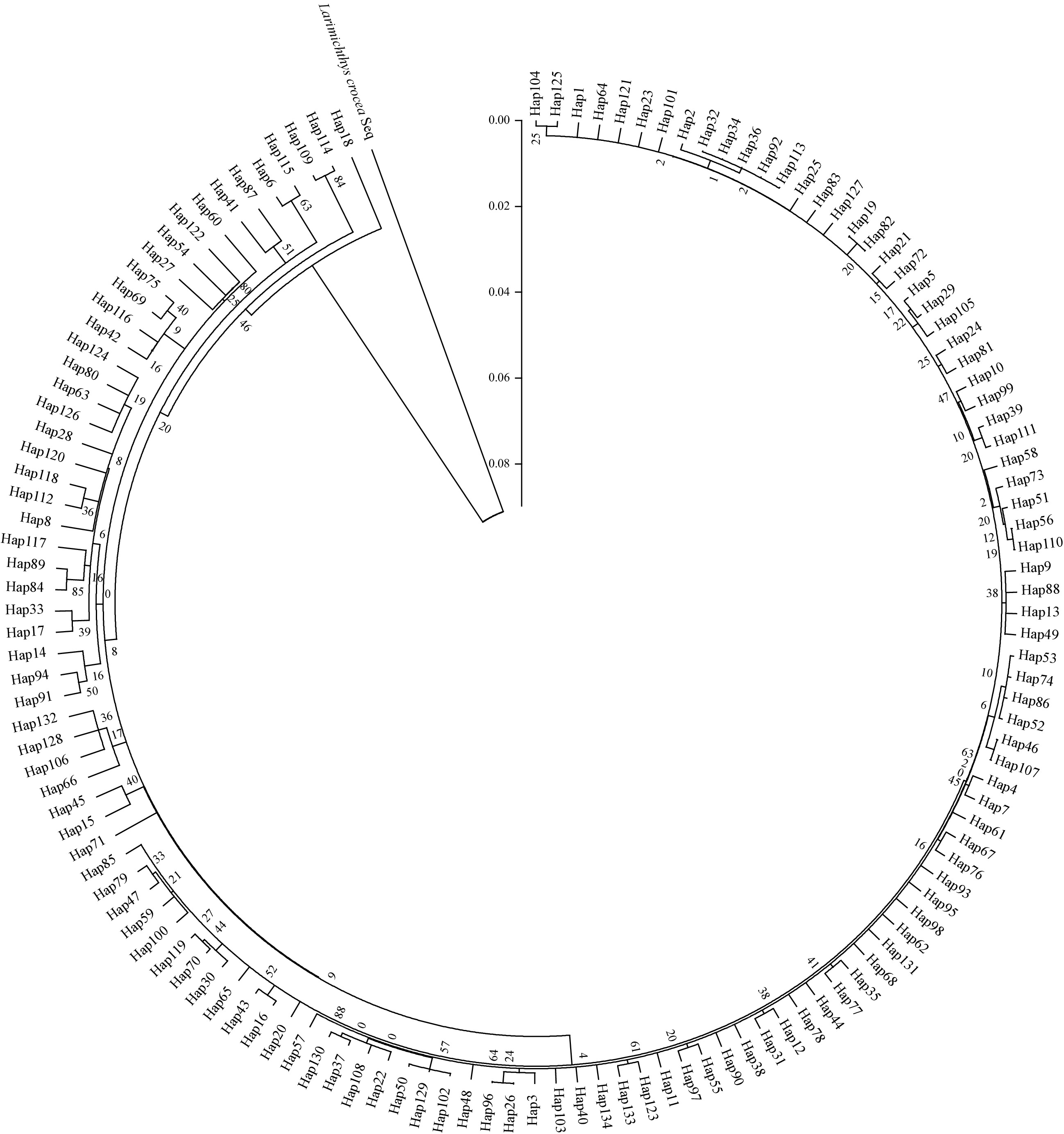
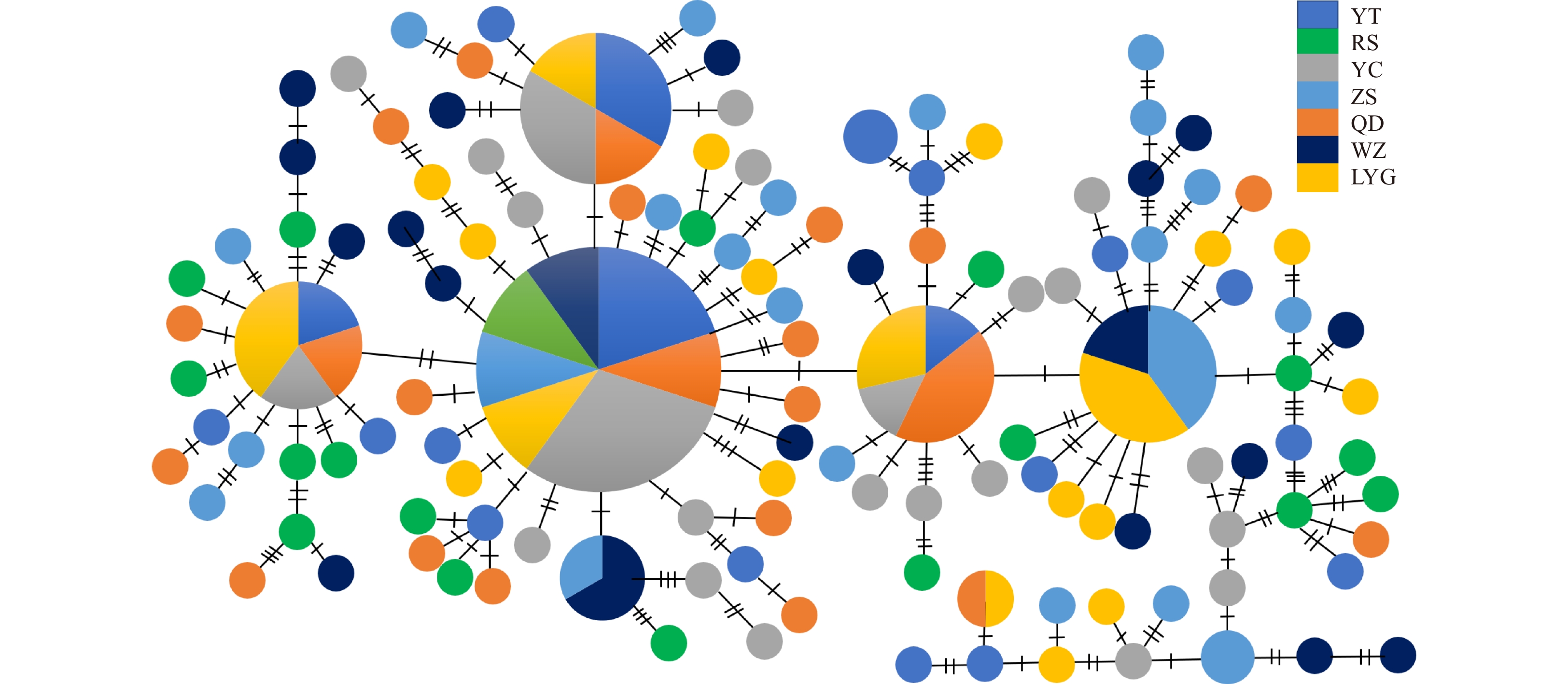
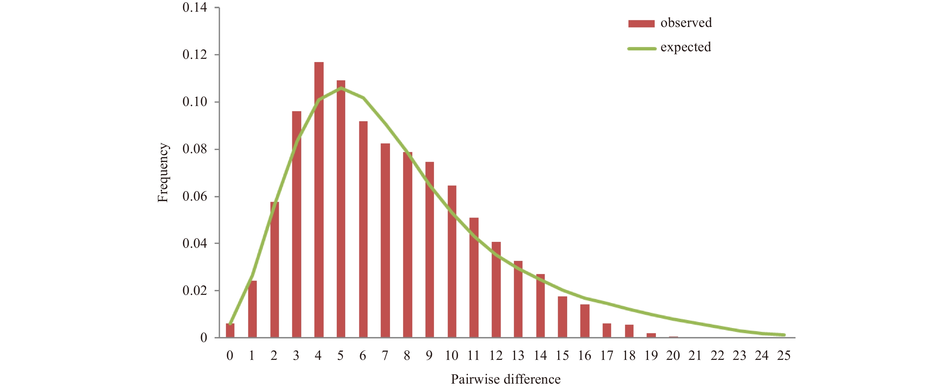
The small yellow croaker (Larimichthys polyactis) belongs to the family Sciaenidae, which is an offshore warm fish species and widely distributed in the western Pacific. In this study, the variation of genetic diversity and genetic differentiation among L. polyactis populations was analyzed by mitochondrial DNA control region. A total of 110 polymorphic sites were checked, which defined 134 haplotypes. High level of haplotype diversity (h=0.993±0.002) was detected in the examined range. Population genetic structure analyse (analysis of molecular variance, Fst) showed there were high gene flow among L. polyactis populations. The result showed that there were relatively high genetic diversity and low genetic differentiation among the Yellow Sea and the East China Sea populations, which can be attributed to diverse habitats, wide distribution range and high mutation rate of control region. Using phylogenetic methods, coalescent analyses (neutrality tests, mismatch distribution analysis, Bayesian skyline analyses) and molecular dating interpreted in conjunction with paleoclimatic and physiographic evidence, we inferred that the genetic make-up of extant populations of L. polyactis was shaped by Pleistocene environmental impacts on the historical demography of this species. Besides, relatively constant genetic diversity and larger effective population size were detected in recent L. polyactis population. The result showed that the fishing policy certainly, such as the summer closed fishing, played a role in protecting resources of L. polyactis. This study can offer a wealth of biological novelties which indicates genetic structure of L. polyactis population and provides the foundation for resources protection and policy setting.
The small yellow croaker (Larimichthys polyactis) belongs to the family Sciaenidae, which is an offshore warm fish species and widely distributed in the western Pacific. In this study, the variation of genetic diversity and genetic differentiation among L. polyactis populations was analyzed by mitochondrial DNA control region. A total of 110 polymorphic sites were checked, which defined 134 haplotypes. High level of haplotype diversity (h=0.993±0.002) was detected in the examined range. Population genetic structure analyse (analysis of molecular variance, Fst) showed there were high gene flow among L. polyactis populations. The result showed that there were relatively high genetic diversity and low genetic differentiation among the Yellow Sea and the East China Sea populations, which can be attributed to diverse habitats, wide distribution range and high mutation rate of control region. Using phylogenetic methods, coalescent analyses (neutrality tests, mismatch distribution analysis, Bayesian skyline analyses) and molecular dating interpreted in conjunction with paleoclimatic and physiographic evidence, we inferred that the genetic make-up of extant populations of L. polyactis was shaped by Pleistocene environmental impacts on the historical demography of this species. Besides, relatively constant genetic diversity and larger effective population size were detected in recent L. polyactis population. The result showed that the fishing policy certainly, such as the summer closed fishing, played a role in protecting resources of L. polyactis. This study can offer a wealth of biological novelties which indicates genetic structure of L. polyactis population and provides the foundation for resources protection and policy setting.


2022, 41(11): 96-107.
doi: 10.1007/s13131-022-2046-9
Abstract:
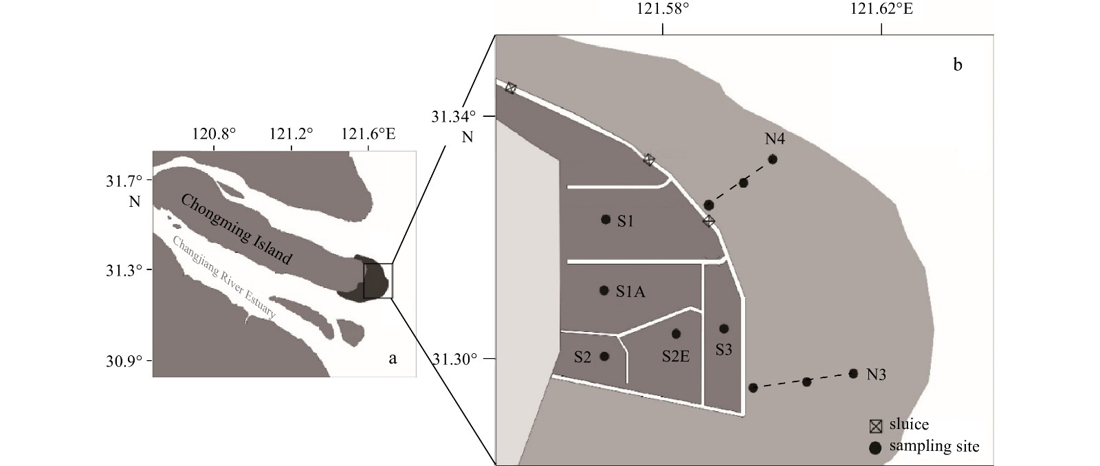
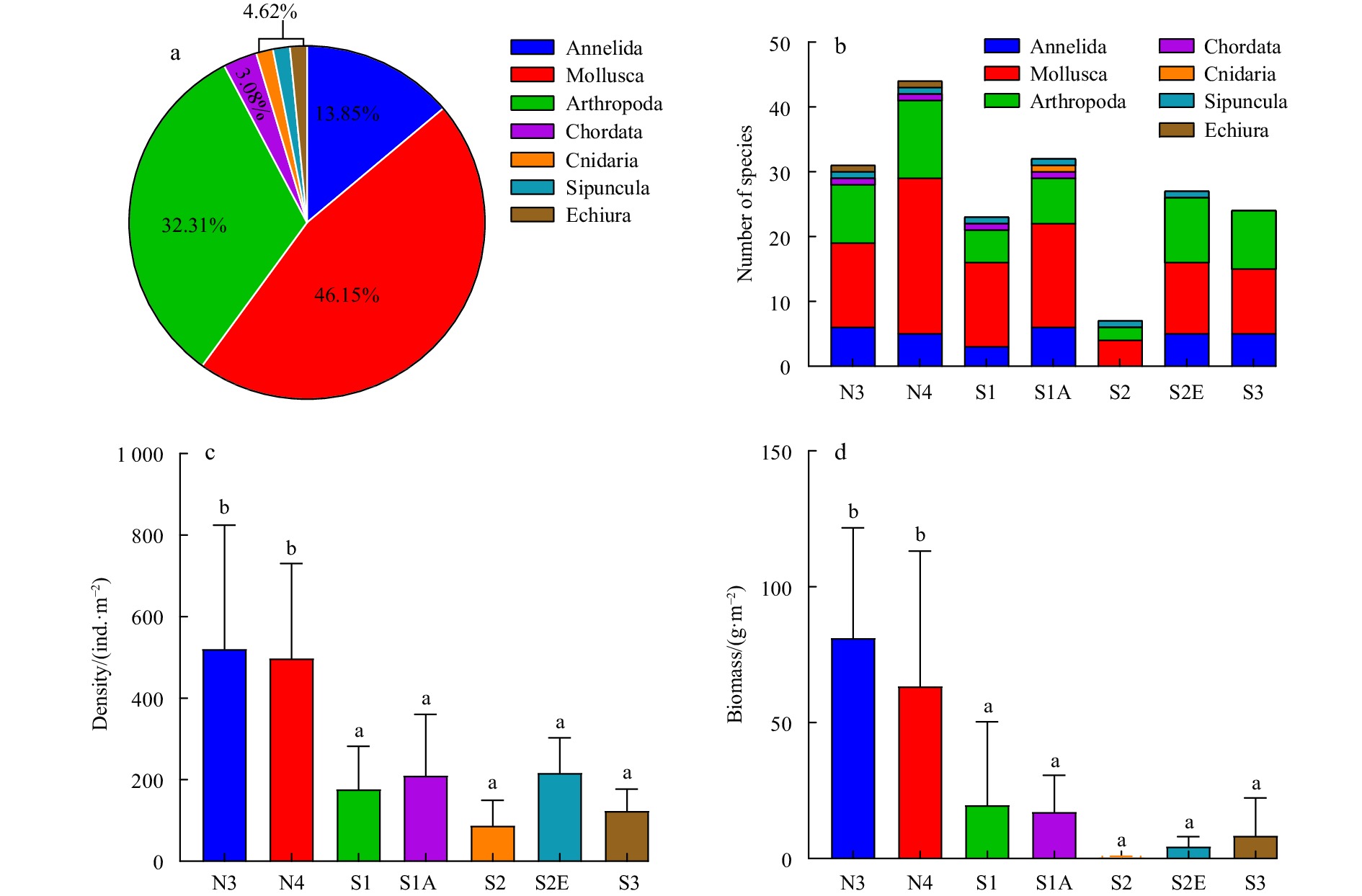
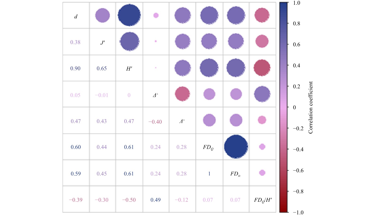
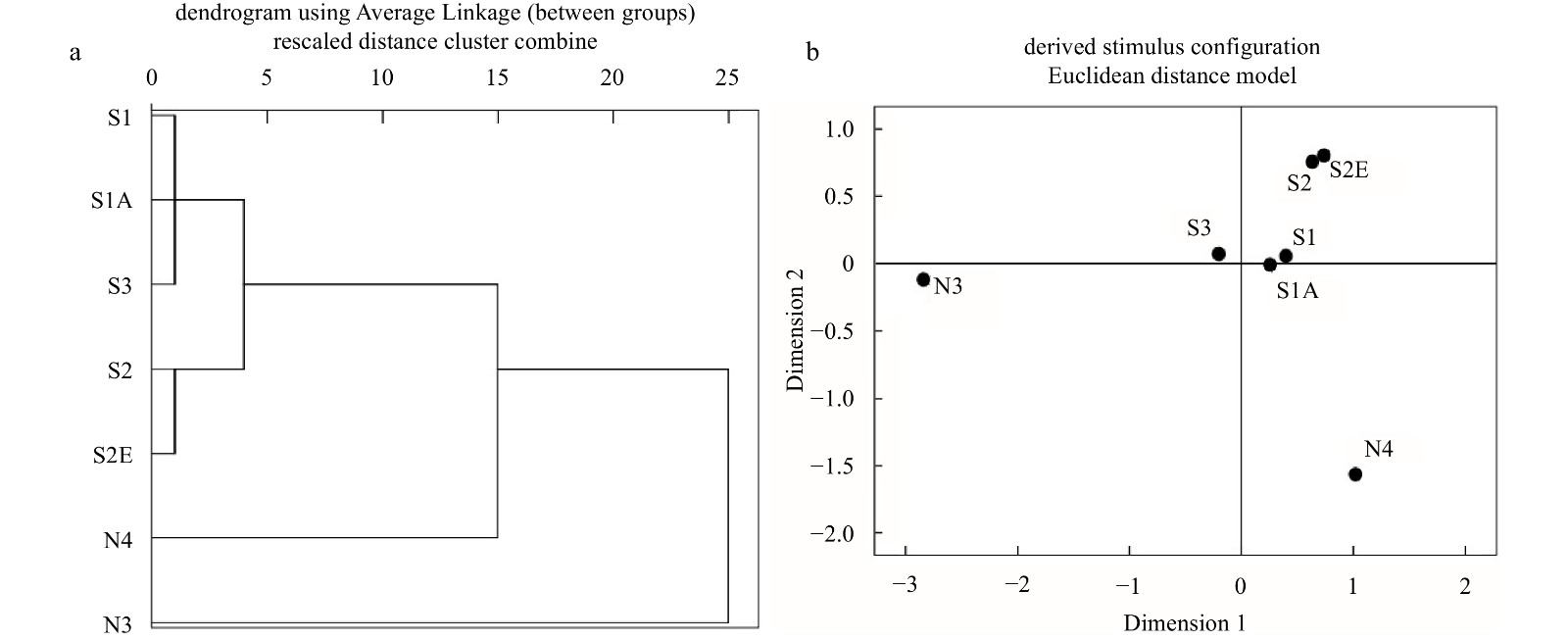
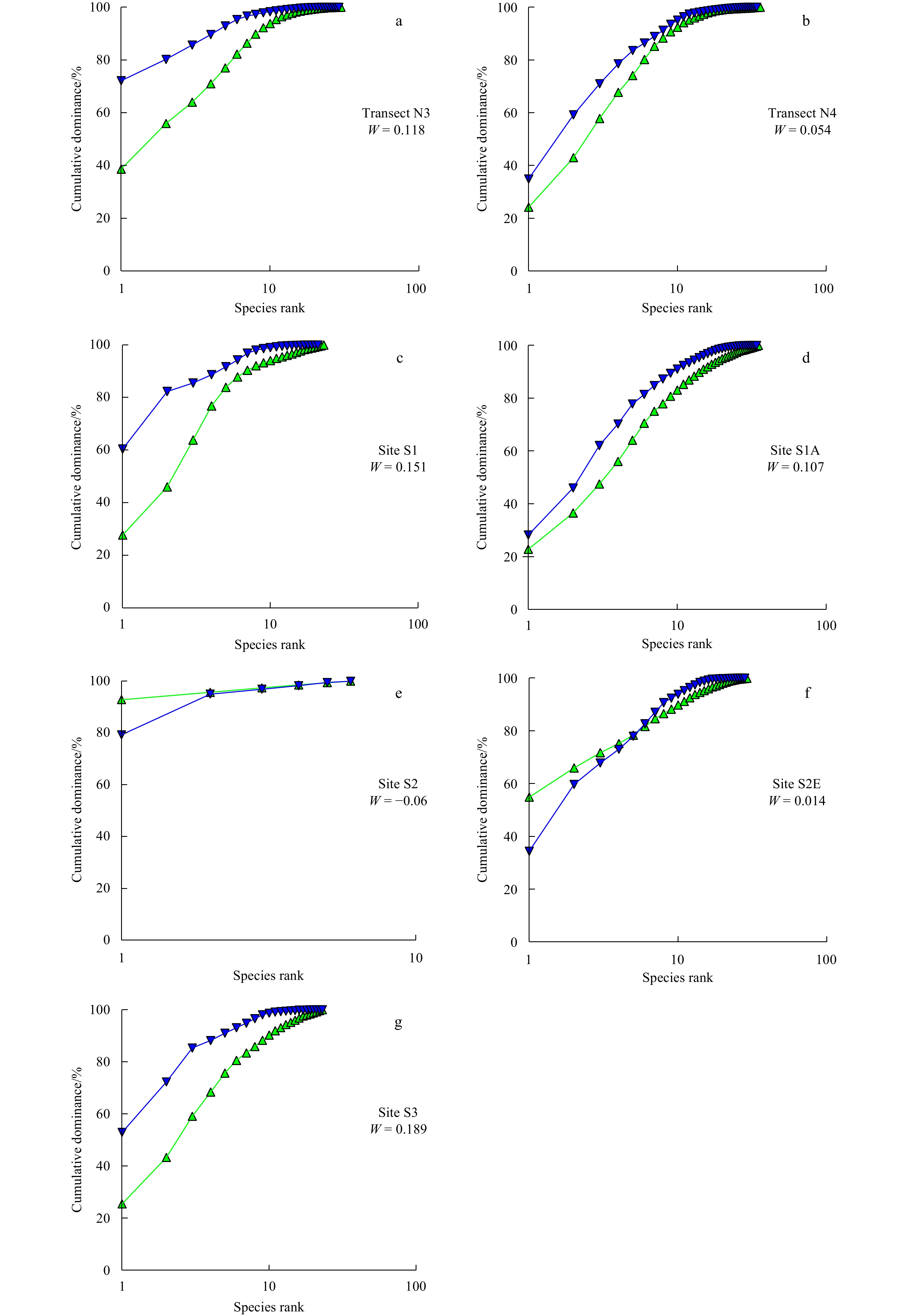
An ecological optimization project (semi-closed reclamation project) was implemented to control the invasion of Spartina alterniflora, and optimize the habitat of the Chongming Dongtan wetland, in the Changjiang (Yangtze) River Estuary. After project implementation, a macrobenthic ecological survey was conducted in a natural tidal flat and a semi-closed reclamation restoration area within the Chongming Dongtan wetland from 2019 to 2020. Compared with historical data before reclamation, findings showed that the groups, numbers, and species diversity of the macrobenthos increased significantly, and the ecological optimization project resulted in good ecological benefits. In addition, compared to the natural tidal flat, the number of collected macrobenthic phyla, and the macrobenthic density and biomass were significantly lower in the restoration area. Furthermore, the biodiversity index and functional redundancy of natural tidal flats were generally higher, indicating that the community composition and function of natural tidal flats were relatively more stable. Even though the species composition differed between a number of restoration areas and natural tidal flats, there was no difference in functional diversity, indicating that the effect of restoring ecological functions in restoration areas was optimal. Among them, the biodiversity and functional redundancy of Site S2 were significantly reduced, and the ecosystem function was extremely unstable. Habitat heterogeneity, vegetation community and decreasing salinity were the main factors that affected the ecological functions of macrobenthos. The ecological quality was also evaluated; the Transects N3 and N4 showed good quality. The overall ecological quality of the restoration area was generally high, but that of Site S2 was poor and that of Site S2E was merely good, which was mainly due to modifications of the ecological function of macrobenthos. It is suggested that reeds mowing and freshwater species release should be adopted in restoration areas to improve the community function and the environmental disturbance resistance of the macrobenthos.
An ecological optimization project (semi-closed reclamation project) was implemented to control the invasion of Spartina alterniflora, and optimize the habitat of the Chongming Dongtan wetland, in the Changjiang (Yangtze) River Estuary. After project implementation, a macrobenthic ecological survey was conducted in a natural tidal flat and a semi-closed reclamation restoration area within the Chongming Dongtan wetland from 2019 to 2020. Compared with historical data before reclamation, findings showed that the groups, numbers, and species diversity of the macrobenthos increased significantly, and the ecological optimization project resulted in good ecological benefits. In addition, compared to the natural tidal flat, the number of collected macrobenthic phyla, and the macrobenthic density and biomass were significantly lower in the restoration area. Furthermore, the biodiversity index and functional redundancy of natural tidal flats were generally higher, indicating that the community composition and function of natural tidal flats were relatively more stable. Even though the species composition differed between a number of restoration areas and natural tidal flats, there was no difference in functional diversity, indicating that the effect of restoring ecological functions in restoration areas was optimal. Among them, the biodiversity and functional redundancy of Site S2 were significantly reduced, and the ecosystem function was extremely unstable. Habitat heterogeneity, vegetation community and decreasing salinity were the main factors that affected the ecological functions of macrobenthos. The ecological quality was also evaluated; the Transects N3 and N4 showed good quality. The overall ecological quality of the restoration area was generally high, but that of Site S2 was poor and that of Site S2E was merely good, which was mainly due to modifications of the ecological function of macrobenthos. It is suggested that reeds mowing and freshwater species release should be adopted in restoration areas to improve the community function and the environmental disturbance resistance of the macrobenthos.
2022, 41(11): 108-114.
doi: 10.1007/s13131-022-1985-5
Abstract:
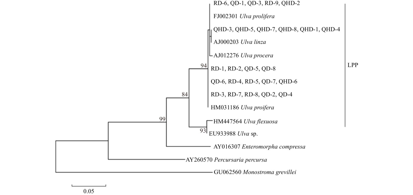
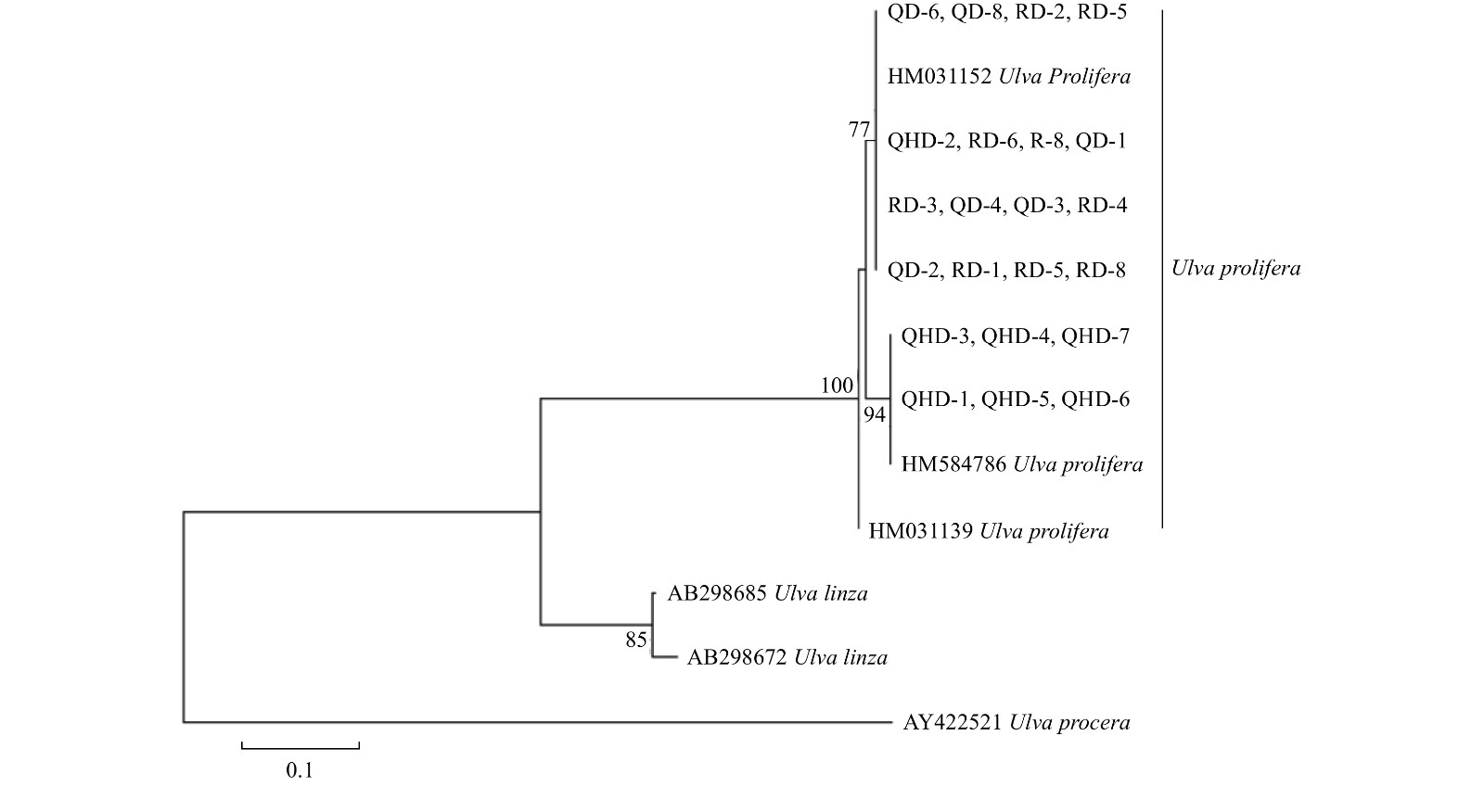
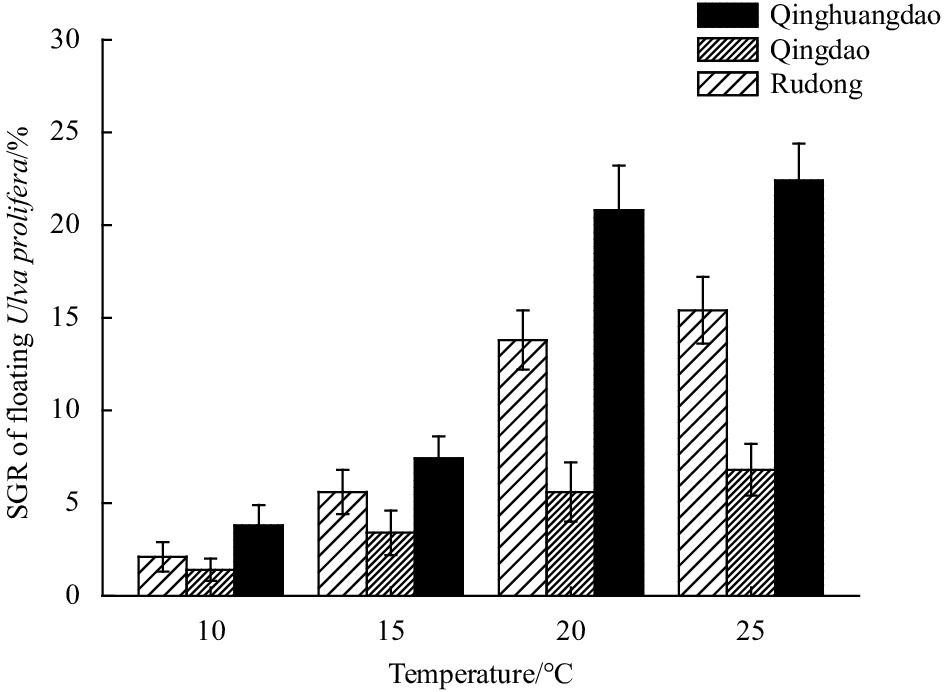
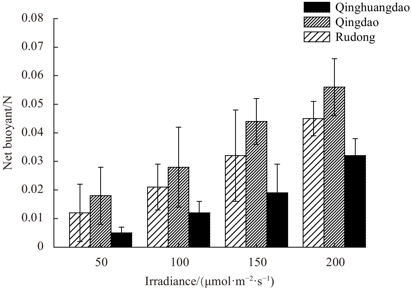
Since 2015, green tides with Ulva prolifera as the dominant species in the Qinhuangdao coastal waters have continued to occur. In this study, the relationship between green tides in Qinhuangdao and the Yellow Sea (setting sites in Rudong and Qingdao) was evaluated by genetic analyses of U. prolifera. Single nucleotide polymorphism (SNP) markers were used to analyze genetic diversity and genetic relationships among groups. Genetic differentiation was lower among floating U. prolifera populations in Rudong and Qingdao than in Qinhuangdao. The floating U. prolifera population had higher genetic diversity and polymorphism levels in Qingdao and Rudong than in Qinhuangdao. Physiological experiments showed that the growth rate and net buoyancy of floating U. prolifera were highest in Qinhuangdao and Qingdao, respectively, under the same environmental conditions (temperature and light). Overall, these findings showed that U. prolifera populations in the Qinhuangdao and Yellow Sea green tides (Rudong and Qingdao) differ significantly at the molecular and physiological levels. Therefore, the Qinhuangdao green tide is not correlated with the Yellow Sea green tide and has a different origin and development mode. This study provides insight into the mechanism underlying green tide blooms in coastal waters of China.
Since 2015, green tides with Ulva prolifera as the dominant species in the Qinhuangdao coastal waters have continued to occur. In this study, the relationship between green tides in Qinhuangdao and the Yellow Sea (setting sites in Rudong and Qingdao) was evaluated by genetic analyses of U. prolifera. Single nucleotide polymorphism (SNP) markers were used to analyze genetic diversity and genetic relationships among groups. Genetic differentiation was lower among floating U. prolifera populations in Rudong and Qingdao than in Qinhuangdao. The floating U. prolifera population had higher genetic diversity and polymorphism levels in Qingdao and Rudong than in Qinhuangdao. Physiological experiments showed that the growth rate and net buoyancy of floating U. prolifera were highest in Qinhuangdao and Qingdao, respectively, under the same environmental conditions (temperature and light). Overall, these findings showed that U. prolifera populations in the Qinhuangdao and Yellow Sea green tides (Rudong and Qingdao) differ significantly at the molecular and physiological levels. Therefore, the Qinhuangdao green tide is not correlated with the Yellow Sea green tide and has a different origin and development mode. This study provides insight into the mechanism underlying green tide blooms in coastal waters of China.


2022, 41(11): 115-125.
doi: 10.1007/s13131-021-1960-6
Abstract:
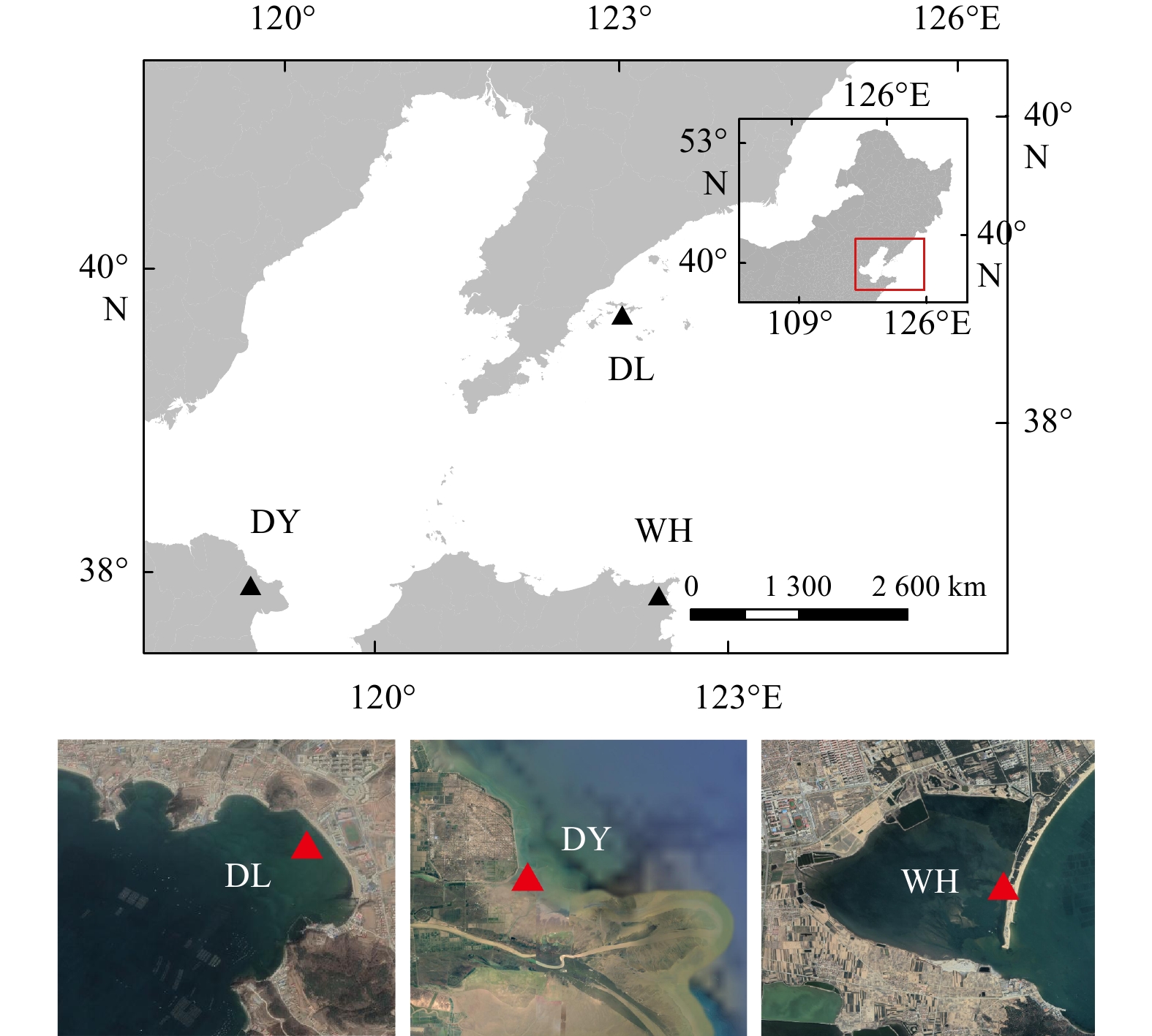
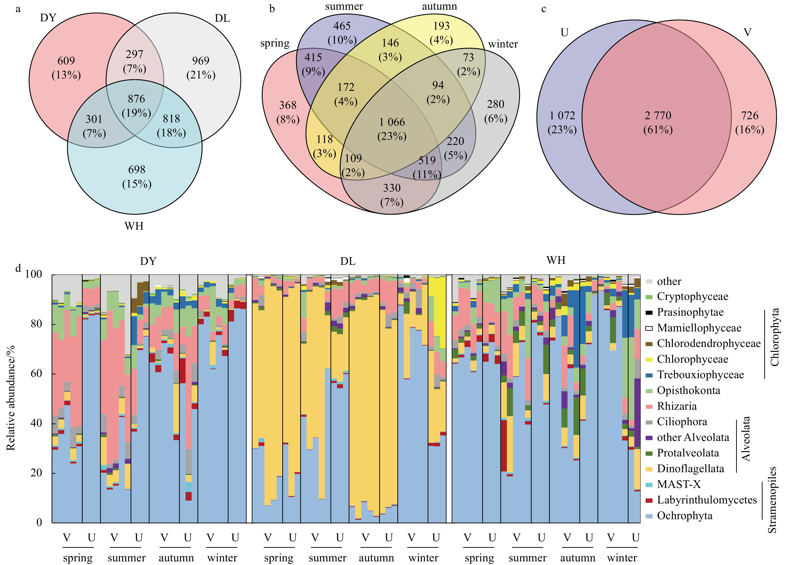
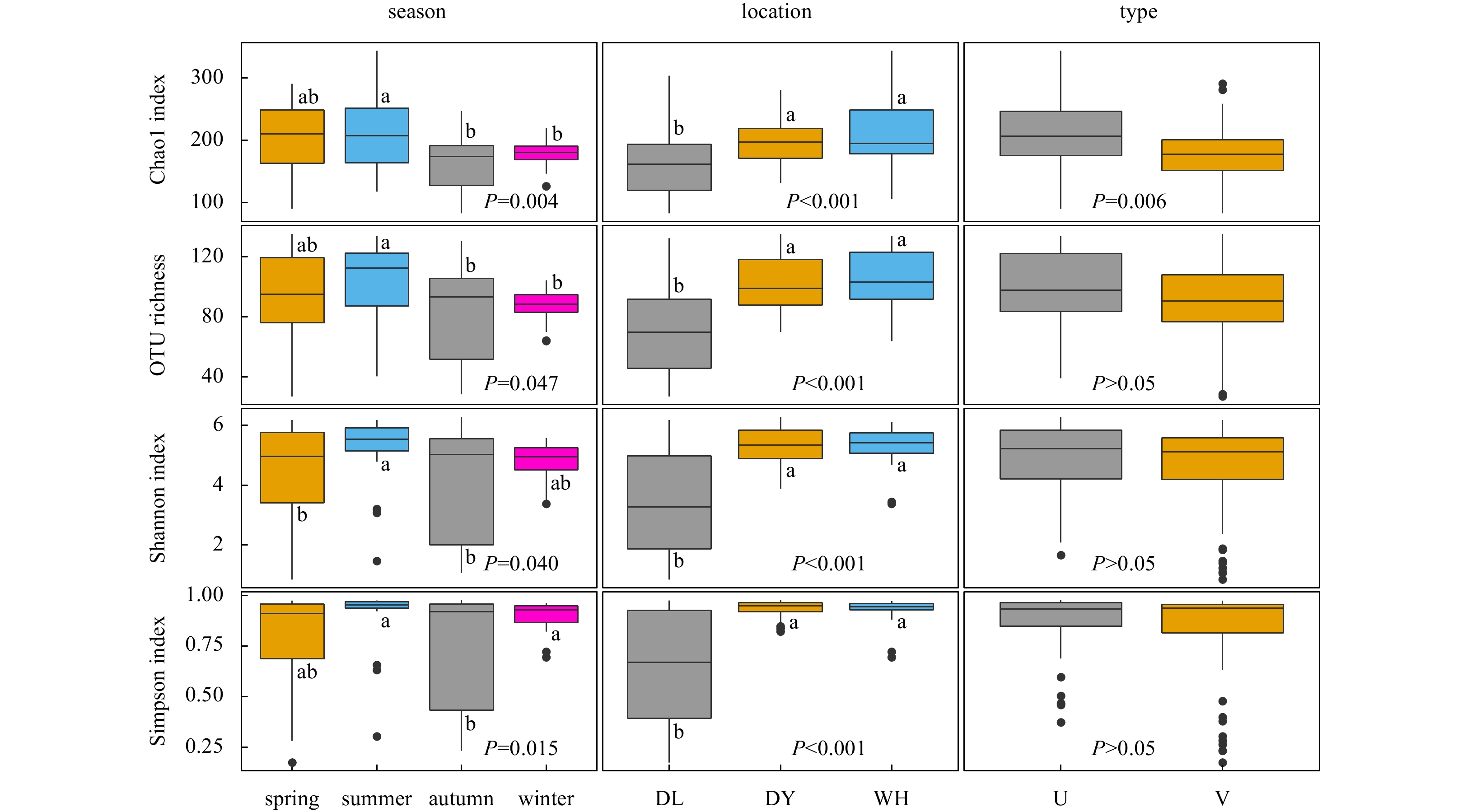
The productivity and health of seagrass depend on the combined inputs of nutrients from the water and sediments in which they grow and the microbiota with which they live intimately. However, little is known about the composition and diversity pattern of single-celled benthic eukaryotes in seagrass meadows. Here, we investigated how the structure and diversity of the benthic microeukaryotic community vary with respect to season, location, and seagrass colonization, by applying 18S rRNA gene amplicon sequencing for 96 surface sediment samples that were collected from three different seagrass habitats through four seasons. We found that benthic microeukaryotic communities associated with seagrass Zostera japonica exhibited remarkable spatial and seasonal variations, as well as differences between vegetated and unvegetated sediments. Diatoms and dinoflagellates predominated in the benthic microeukaryotic communities, but they were inversely correlated and displaced each other as the dominant microbial group in different seasons or habitats. Mucoromycota was more prevalent in vegetated sediments, whereas Lobulomycetales and Chytridiales had higher proportions in unvegetated sites. Total organic carbon and total organic nitrogen were the most important environmental factors in driving the microeukaryotic assemblages and diversity. Our study expands the available knowledge on the biogeographic distribution patterns and niche preferences for benthic microeukaryotes in seagrass systems.
The productivity and health of seagrass depend on the combined inputs of nutrients from the water and sediments in which they grow and the microbiota with which they live intimately. However, little is known about the composition and diversity pattern of single-celled benthic eukaryotes in seagrass meadows. Here, we investigated how the structure and diversity of the benthic microeukaryotic community vary with respect to season, location, and seagrass colonization, by applying 18S rRNA gene amplicon sequencing for 96 surface sediment samples that were collected from three different seagrass habitats through four seasons. We found that benthic microeukaryotic communities associated with seagrass Zostera japonica exhibited remarkable spatial and seasonal variations, as well as differences between vegetated and unvegetated sediments. Diatoms and dinoflagellates predominated in the benthic microeukaryotic communities, but they were inversely correlated and displaced each other as the dominant microbial group in different seasons or habitats. Mucoromycota was more prevalent in vegetated sediments, whereas Lobulomycetales and Chytridiales had higher proportions in unvegetated sites. Total organic carbon and total organic nitrogen were the most important environmental factors in driving the microeukaryotic assemblages and diversity. Our study expands the available knowledge on the biogeographic distribution patterns and niche preferences for benthic microeukaryotes in seagrass systems.
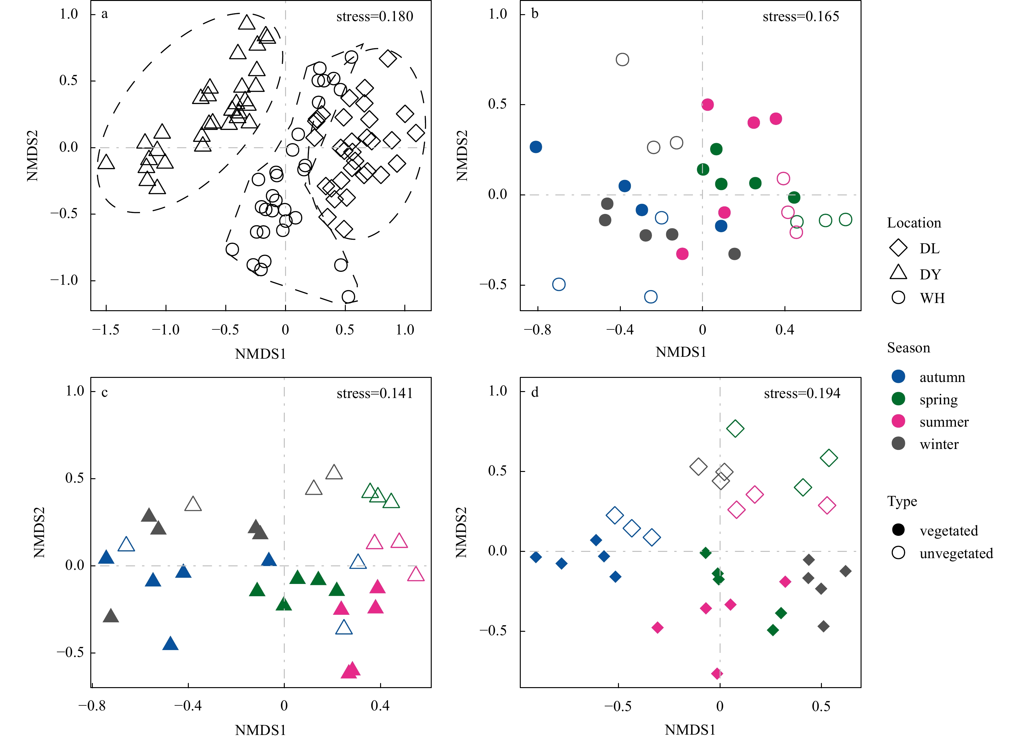

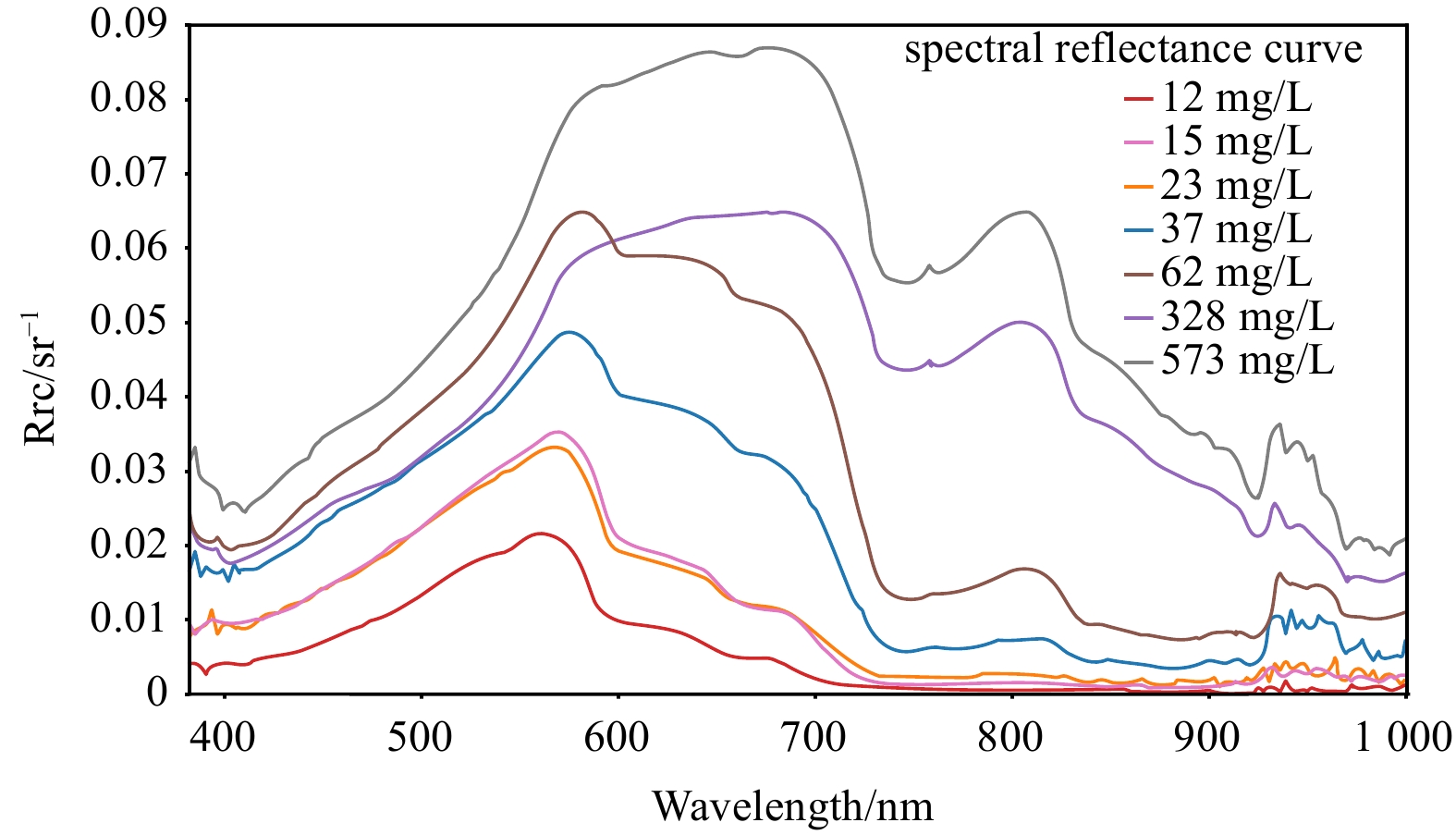
2022, 41(11): 126-138.
doi: 10.1007/s13131-022-2107-0
Abstract:
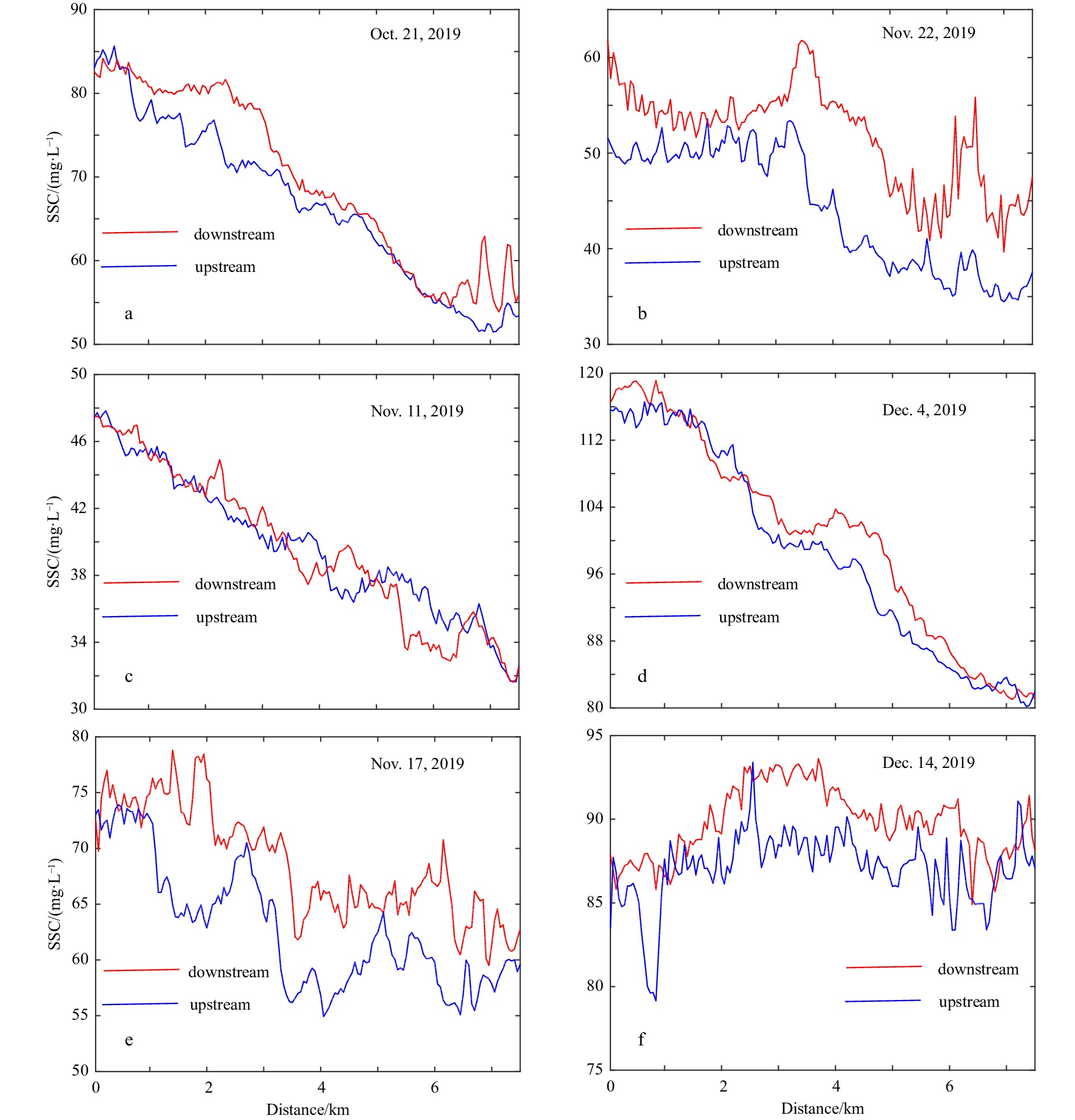
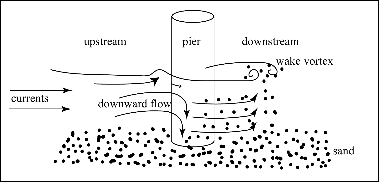
The impacts of the Hong Kong-Zhuhai-Macao Bridge (HKZMB) on suspended sediment content (SSC) were analysed in the Zhujiang River Estuary based on data from HY-1C, which was launched in September 2018 in China, carrying Coastal Zone Imager (CZI) and Chinese Ocean Color and Temperature Scanner on it. A new SSC inversion model was established based on the relationship between in-situ SSC and the remote sensing reflectance in red and near-infrared bands of CZI image. HY-1C satellite data obtained from October to December 2019 were applied to retrieve SSC in the Zhujiang River Estuary. The results show that SSC around the HKZMB is ranging from 20 mg/L to 95 mg/L. SSC change obviously on two sides of the bridge. During flooding and ebbing period, SSC increases obviously downstream of the bridge. SSC difference between upstream and downstream is ranging from 5 mg/L to 20 mg/L. Currents flowing across the HKZMB, the change trend of SSC in most places upstream and downstream is almost the same that SSC downstream of the bridge is higher than SSC upstream. The tidal currents interact with bridge piers, inducing vortexes downstream, leading the sediment to re-suspend downstream of the bridge piers. Other factors, including seafloor topography and wind, can also contribute to the distribution of SSC in the Zhujiang River Estuary.
The impacts of the Hong Kong-Zhuhai-Macao Bridge (HKZMB) on suspended sediment content (SSC) were analysed in the Zhujiang River Estuary based on data from HY-1C, which was launched in September 2018 in China, carrying Coastal Zone Imager (CZI) and Chinese Ocean Color and Temperature Scanner on it. A new SSC inversion model was established based on the relationship between in-situ SSC and the remote sensing reflectance in red and near-infrared bands of CZI image. HY-1C satellite data obtained from October to December 2019 were applied to retrieve SSC in the Zhujiang River Estuary. The results show that SSC around the HKZMB is ranging from 20 mg/L to 95 mg/L. SSC change obviously on two sides of the bridge. During flooding and ebbing period, SSC increases obviously downstream of the bridge. SSC difference between upstream and downstream is ranging from 5 mg/L to 20 mg/L. Currents flowing across the HKZMB, the change trend of SSC in most places upstream and downstream is almost the same that SSC downstream of the bridge is higher than SSC upstream. The tidal currents interact with bridge piers, inducing vortexes downstream, leading the sediment to re-suspend downstream of the bridge piers. Other factors, including seafloor topography and wind, can also contribute to the distribution of SSC in the Zhujiang River Estuary.