2021 Vol. 40, No. 11

Cover
2021, 40(11): .
Abstract:
2021-11 Contents
2021, 40(11): 0-1.
Abstract:
Physical Oceanography, Marine Meteorology and Marine Physics
Estimate of contribution of near-inertial waves to the velocity shear in the Bay of Bengal based on mooring observations from 2013 to 2014
Shanwu Zhang, Yun Qiu, Hangyu Chen, Junqiang Shen, Junpeng Zhang, Jing Cha, Fuwen Qiu, Chunsheng Jing
2021, 40(11): 1-10. doi: 10.1007/s13131-021-1743-0
Abstract:
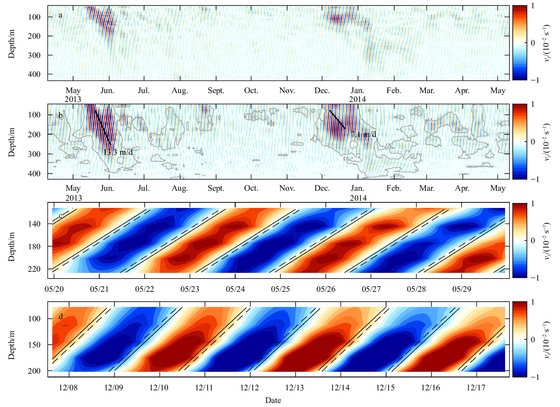
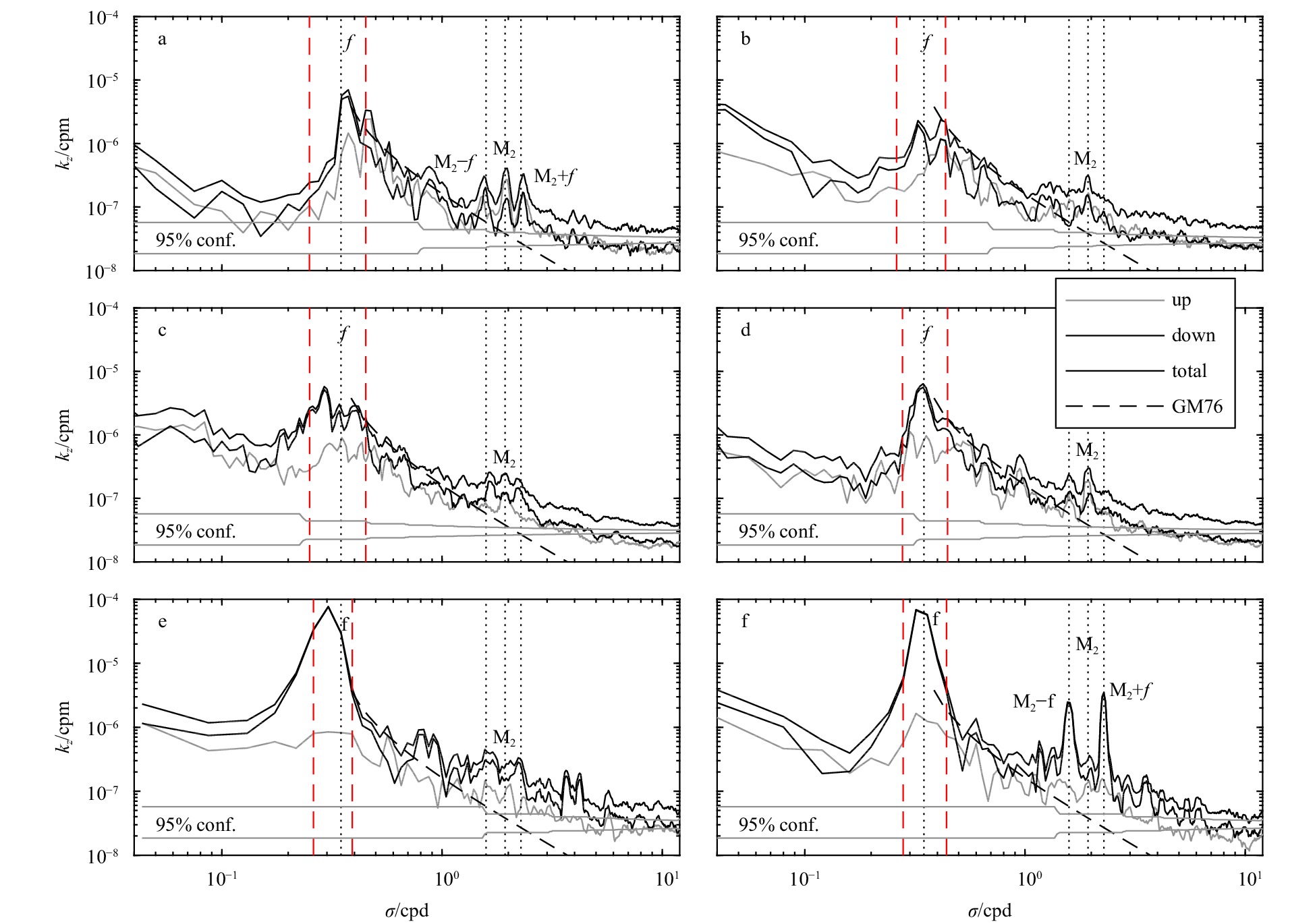
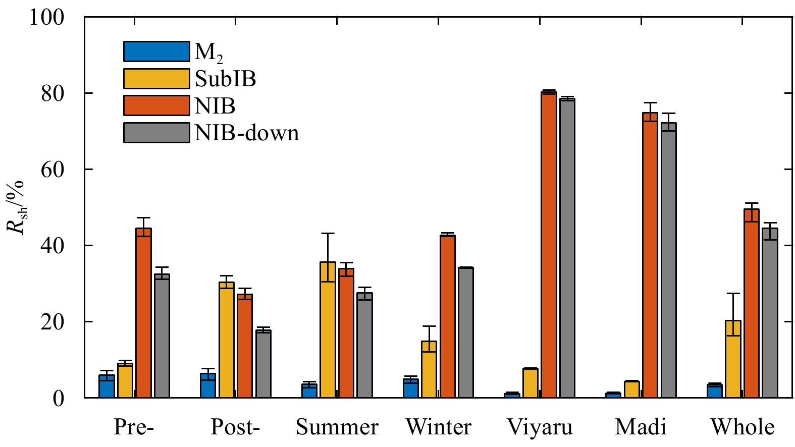
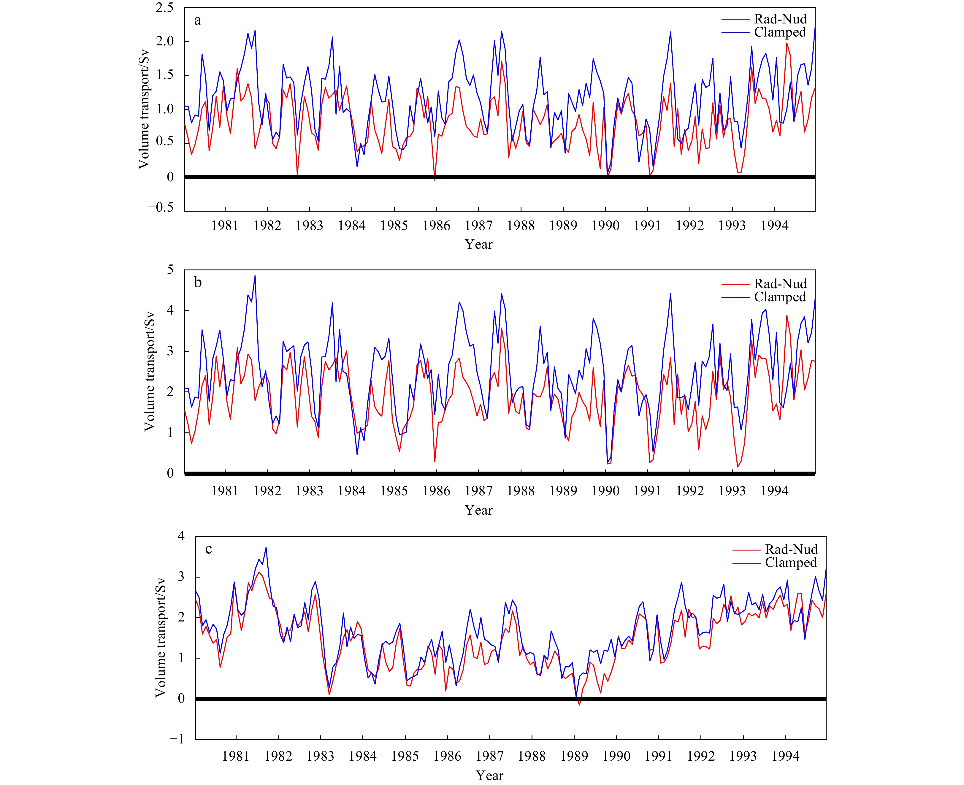
Near-inertial motions contribute most of the velocity shear in the upper ocean. In the Bay of Bengal (BoB), the annual-mean energy flux from the wind to near-inertial motions in the mixed layer in 2013 is dominated by tropical cyclone (TC) processes. However, due to the lack of long-term observations of velocity profiles, our knowledge about interior near-inertial waves (NIWs) as well as their shear features is limited. In this study, we quantified the contribution of NIWs to shear by integrating the wavenumber-frequency spectra estimated from velocity profiles in the upper layers (40−440 m) of the southern BoB from April 2013 to May 2014. It is shown that the annual-mean proportion of near-inertial shear out of the total is approximately 50%, and the high contribution is mainly due to the enhancement of the TC processes during which the near-inertial shear accounts for nearly 80% of the total. In the steady monsoon seasons, the near-inertial shear is dominant to or at least comparable with the subinertial shear. The contribution of NIWs to the total shear is lower during the summer monsoon than during the winter monsoon owing to more active mesoscale eddies and higher subinertial shear during the summer monsoon. The Doppler shifting of the M2 internal tide has little effect on the main results since the proportion of shear from the tidal motions is much lower than that from the near-inertial and subinertial motions.
Observations and modelling of the travel time delay and leading negative phase of the 16 September 2015 Illapel, Chile tsunami
Peitao Wang, Zhiyuan Ren, Lining Sun, Jingming Hou, Zongchen Wang, Ye Yuan, Fujiang Yu
2021, 40(11): 11-30. doi: 10.1007/s13131-021-1830-2
Abstract:
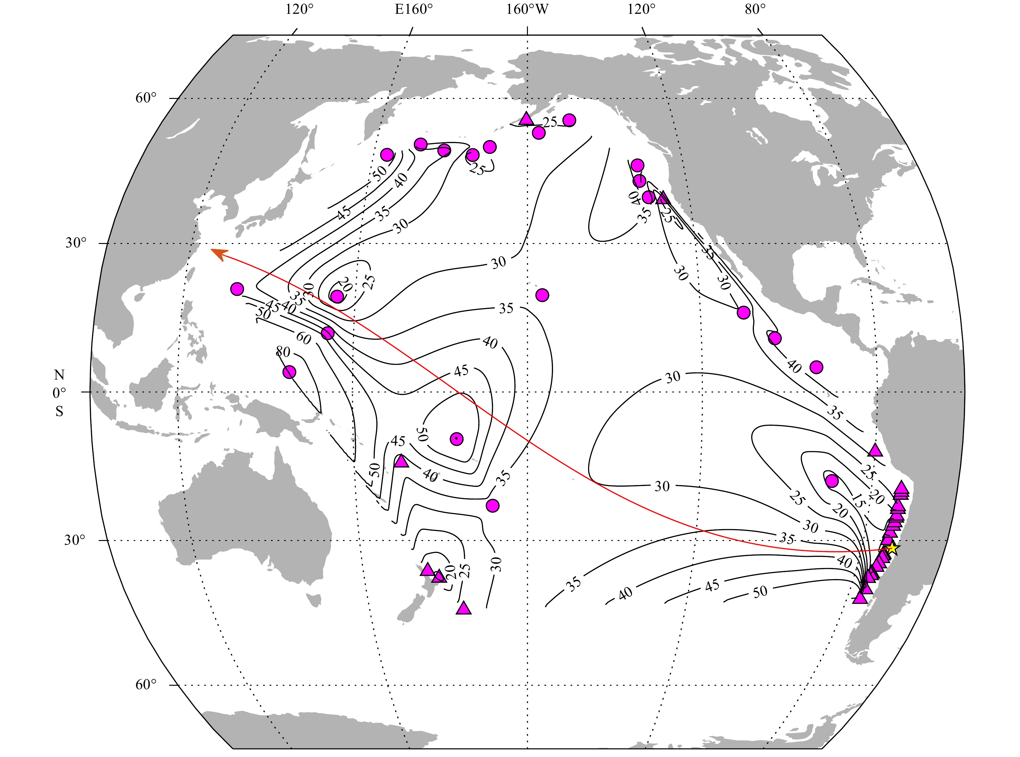
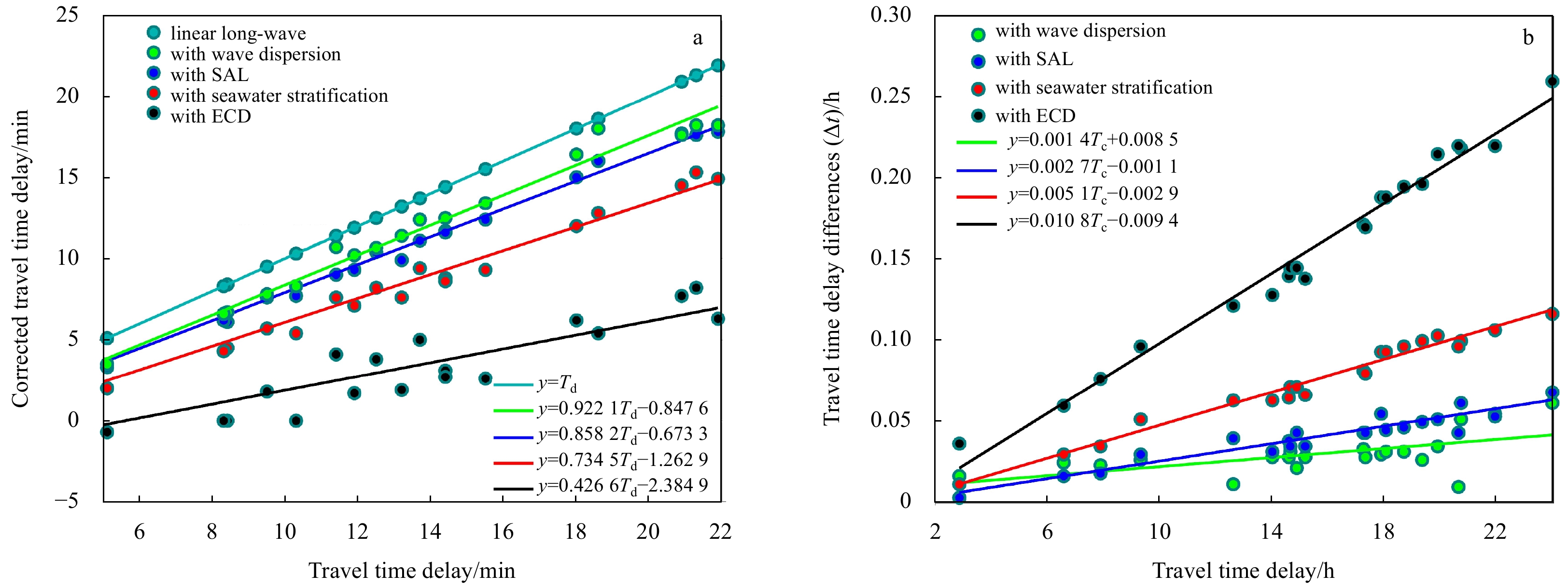
The systematic discrepancies in both tsunami arrival time and leading negative phase (LNP) were identified for the recent transoceanic tsunami on 16 September 2015 in Illapel, Chile by examining the wave characteristics from the tsunami records at 21 Deep-ocean Assessment and Reporting of Tsunami (DART) sites and 29 coastal tide gauge stations. The results revealed systematic travel time delay of as much as 22 min (approximately 1.7% of the total travel time) relative to the simulated long waves from the 2015 Chilean tsunami. The delay discrepancy was found to increase with travel time. It was difficult to identify the LNP from the near-shore observation system due to the strong background noise, but the initial negative phase feature became more obvious as the tsunami propagated away from the source area in the deep ocean. We determined that the LNP for the Chilean tsunami had an average duration of 33 min, which was close to the dominant period of the tsunami source. Most of the amplitude ratios to the first elevation phase were approximately 40%, with the largest equivalent to the first positive phase amplitude. We performed numerical analyses by applying the corrected long wave model, which accounted for the effects of seawater density stratification due to compressibility, self-attraction and loading (SAL) of the earth, and wave dispersion compared with observed tsunami waveforms. We attempted to accurately calculate the arrival time and LNP, and to understand how much of a role the physical mechanism played in the discrepancies for the moderate transoceanic tsunami event. The mainly focus of the study is to quantitatively evaluate the contribution of each secondary physical effect to the systematic discrepancies using the corrected shallow water model. Taking all of these effects into consideration, our results demonstrated good agreement between the observed and simulated waveforms. We can conclude that the corrected shallow water model can reduce the tsunami propagation speed and reproduce the LNP, which is observed for tsunamis that have propagated over long distances frequently. The travel time delay between the observed and corrected simulated waveforms is reduced to <8 min and the amplitude discrepancy between them was also markedly diminished. The incorporated effects amounted to approximately 78% of the travel time delay correction, with seawater density stratification, SAL, and Boussinesq dispersion contributing approximately 39%, 21%, and 18%, respectively. The simulated results showed that the elastic loading and Boussinesq dispersion not only affected travel time but also changed the simulated waveforms for this event. In contrast, the seawater stratification only reduced the tsunami speed, whereas the earth’s elasticity loading was responsible for LNP due to the depression of the seafloor surrounding additional tsunami loading at far-field stations. This study revealed that the traditional shallow water model has inherent defects in estimating tsunami arrival, and the leading negative phase of a tsunami is a typical recognizable feature of a moderately strong transoceanic tsunami. These results also support previous theory and can help to explain the observed discrepancies.
Decadal variation of thermocline-sea surface temperature feedback in the tropical Indian Ocean and the underlying mechanisms
Meiqi Zhang, Shuangwen Sun, Lin Liu, Yongcan Zu, Lin Feng
2021, 40(11): 31-38. doi: 10.1007/s13131-021-1950-8
Abstract:
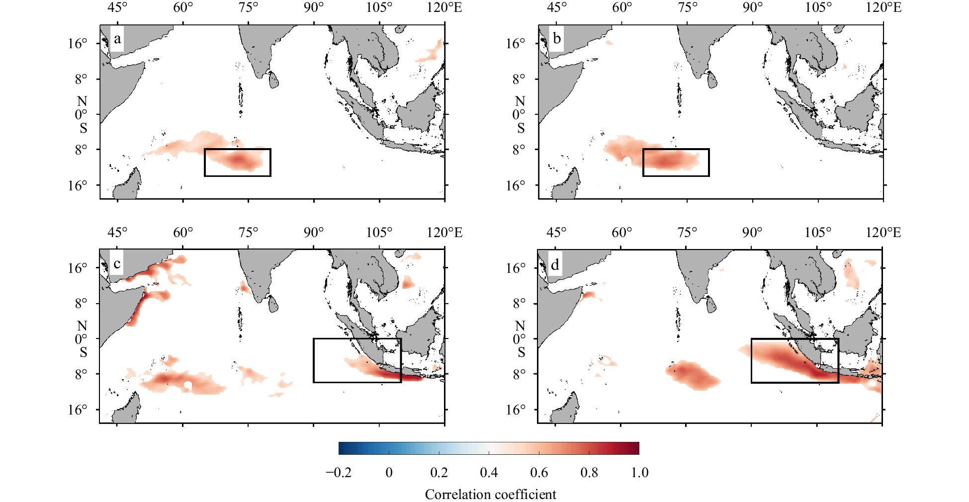
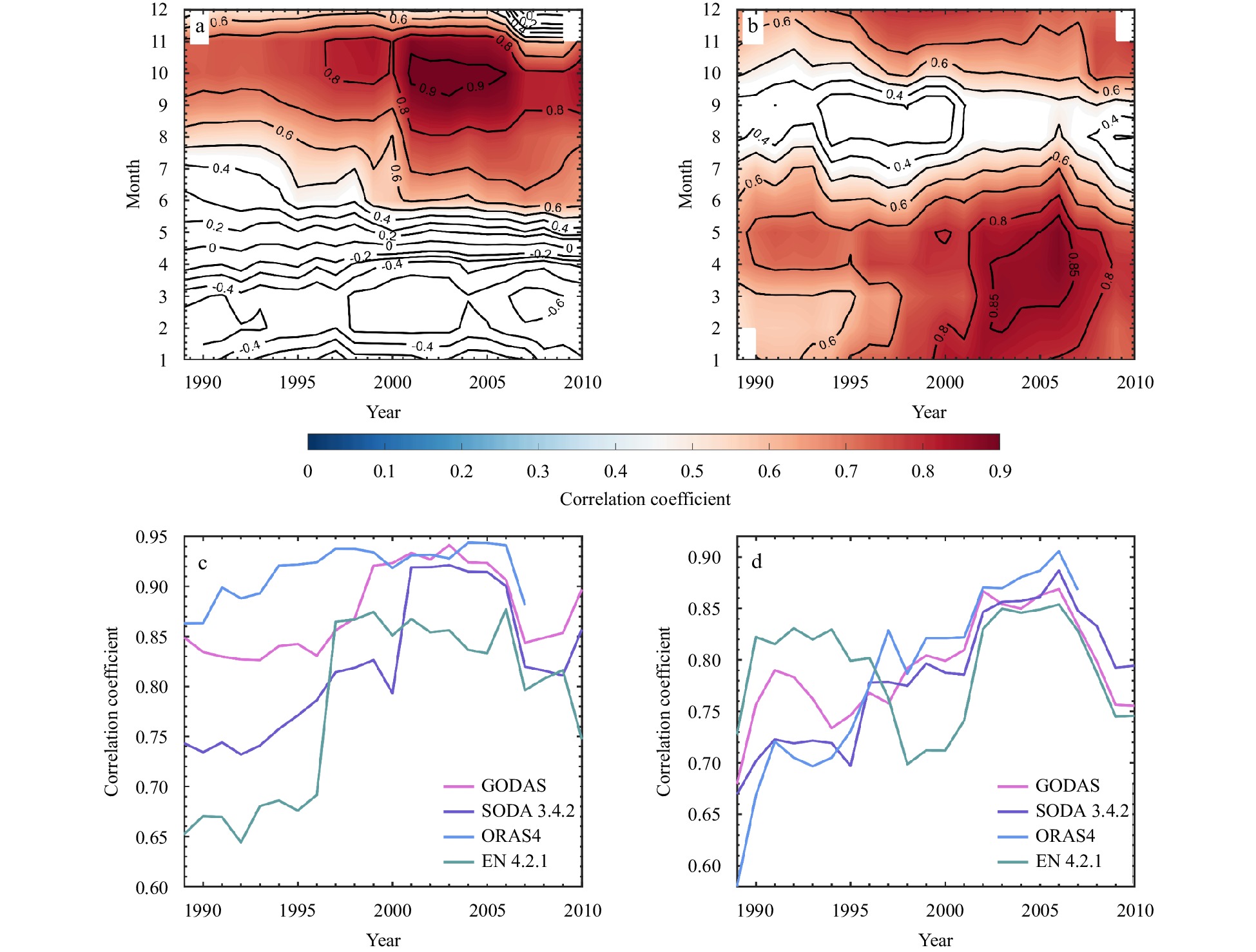
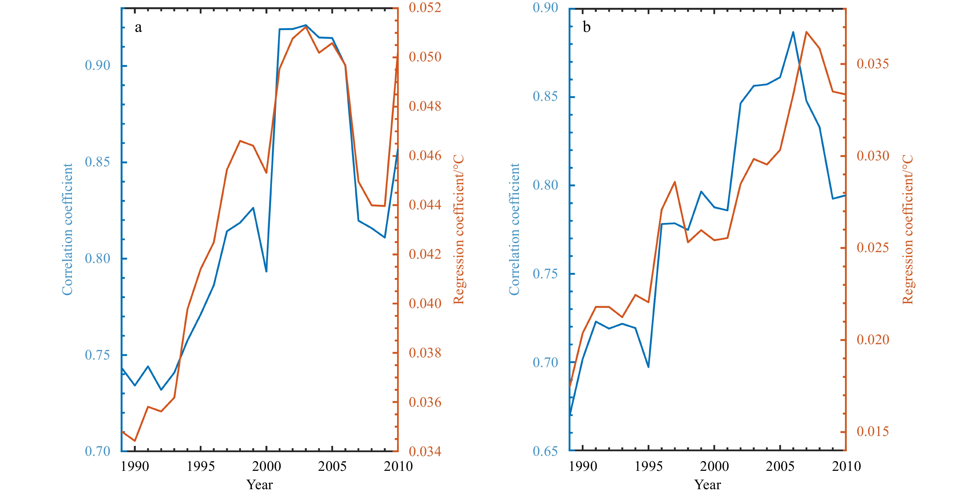
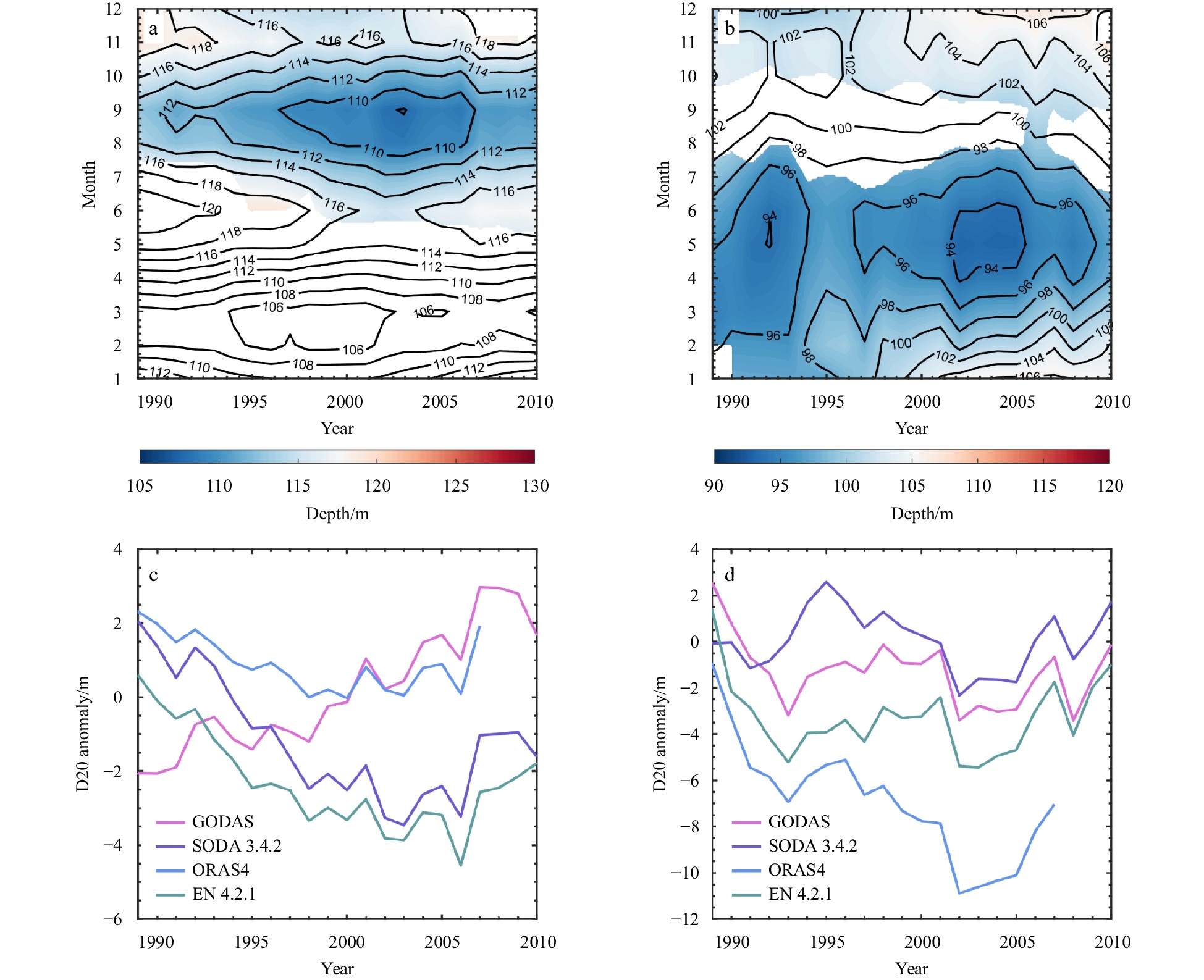
The thermocline-sea surface temperature (SST) feedback is the most important component of the Bjerknes feedback, which plays an important role in the development of the air-sea coupling modes of the Indian Ocean. The thermocline-SST feedback in the Indian Ocean has experienced significant decadal variations over the last 40 a. The feedback intensified in the late twentieth century and then weakened during the hiatus in global warming at the early twenty-first century. The thermocline-SST feedback is most prominent in the southeastern and southwestern Indian Ocean. Although the decadal variations of feedback are similar in these two regions, there are still differences in the underlying mechanisms. The decadal variations of feedback in the southeastern Indian Ocean are dominated by variations in the depth of the thermocline, which are modulated by equatorial zonal wind anomalies. Whereas the decadal variation of feedback in the southwestern Indian Ocean is mainly controlled by the intensity of upwelling and thermocline depth in winter and spring, respectively. The upwelling and thermocline depth are both affected by wind stress curl anomalies over the southeastern Indian Ocean, which excite anomalous Ekman pumping and influence the southwestern Indian Ocean through westward propagating Rossby waves.
Oceanic vertical mixing of the lower halocline water in the Chukchi Borderland and Mendeleyev Ridge
Long Lin, Hailun He, Yong Cao, Tao Li, Yilin Liu, Mingfeng Wang
2021, 40(11): 39-49. doi: 10.1007/s13131-021-1825-z
Abstract:
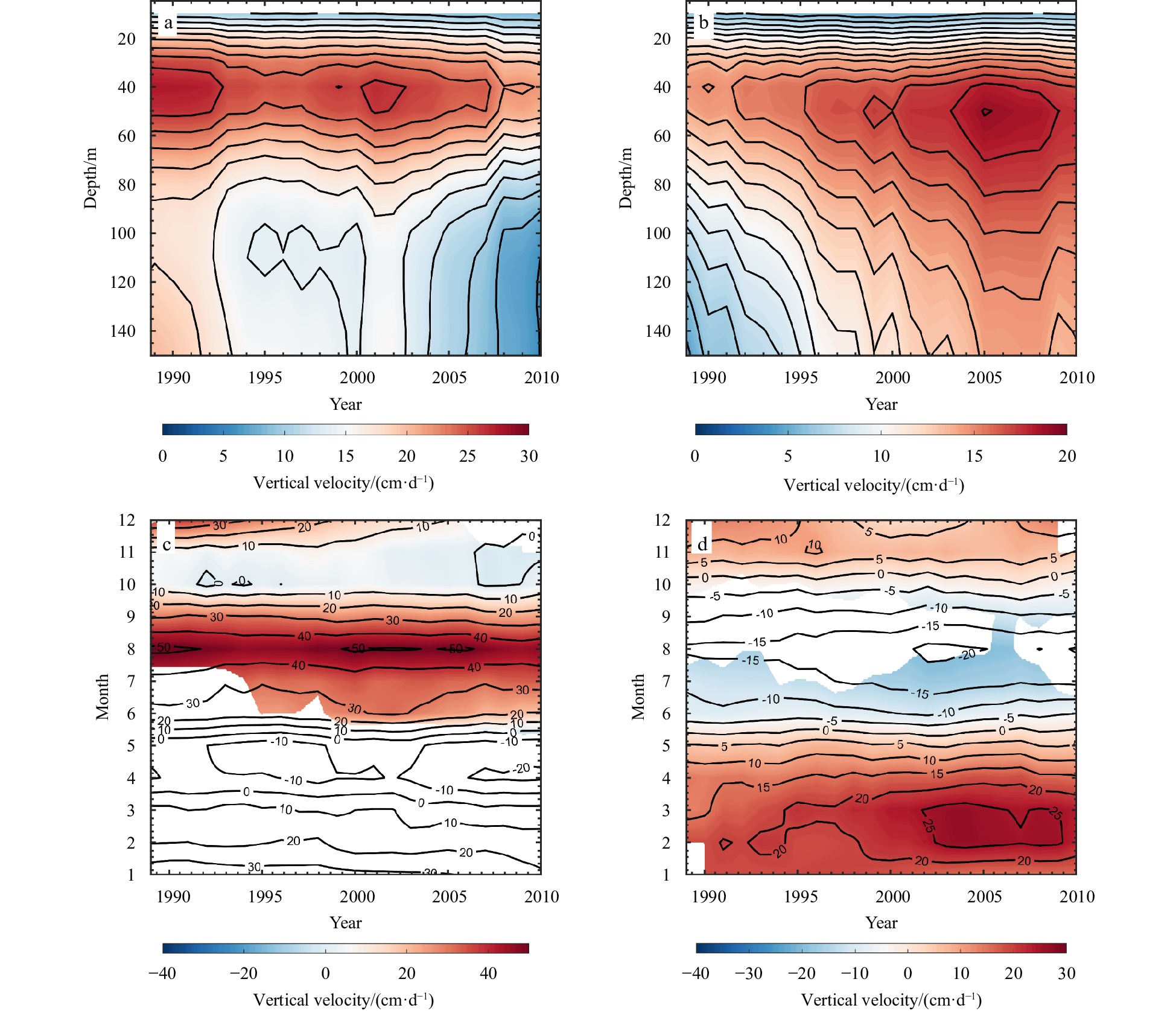
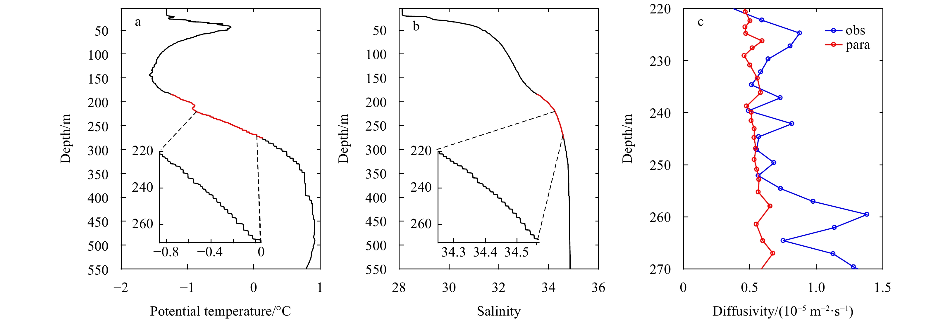
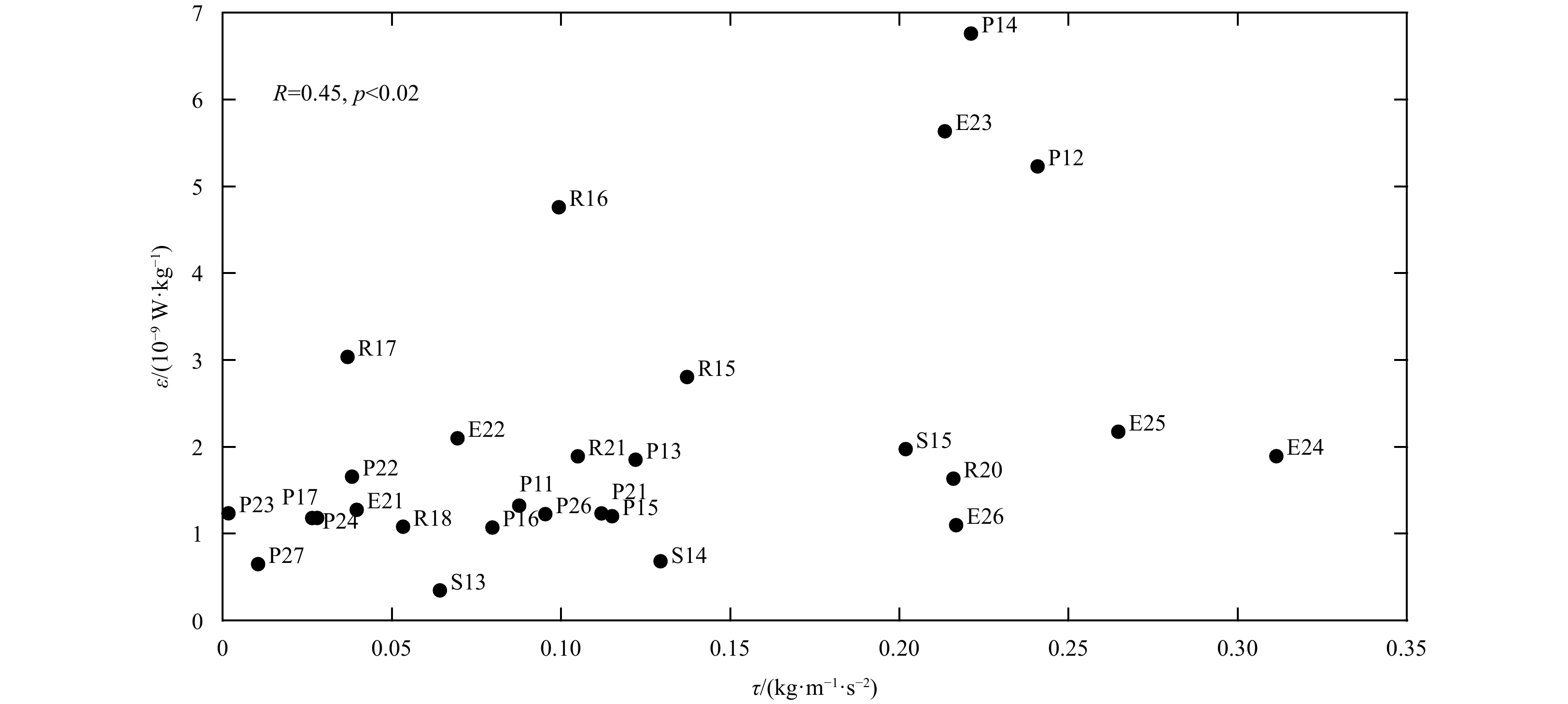
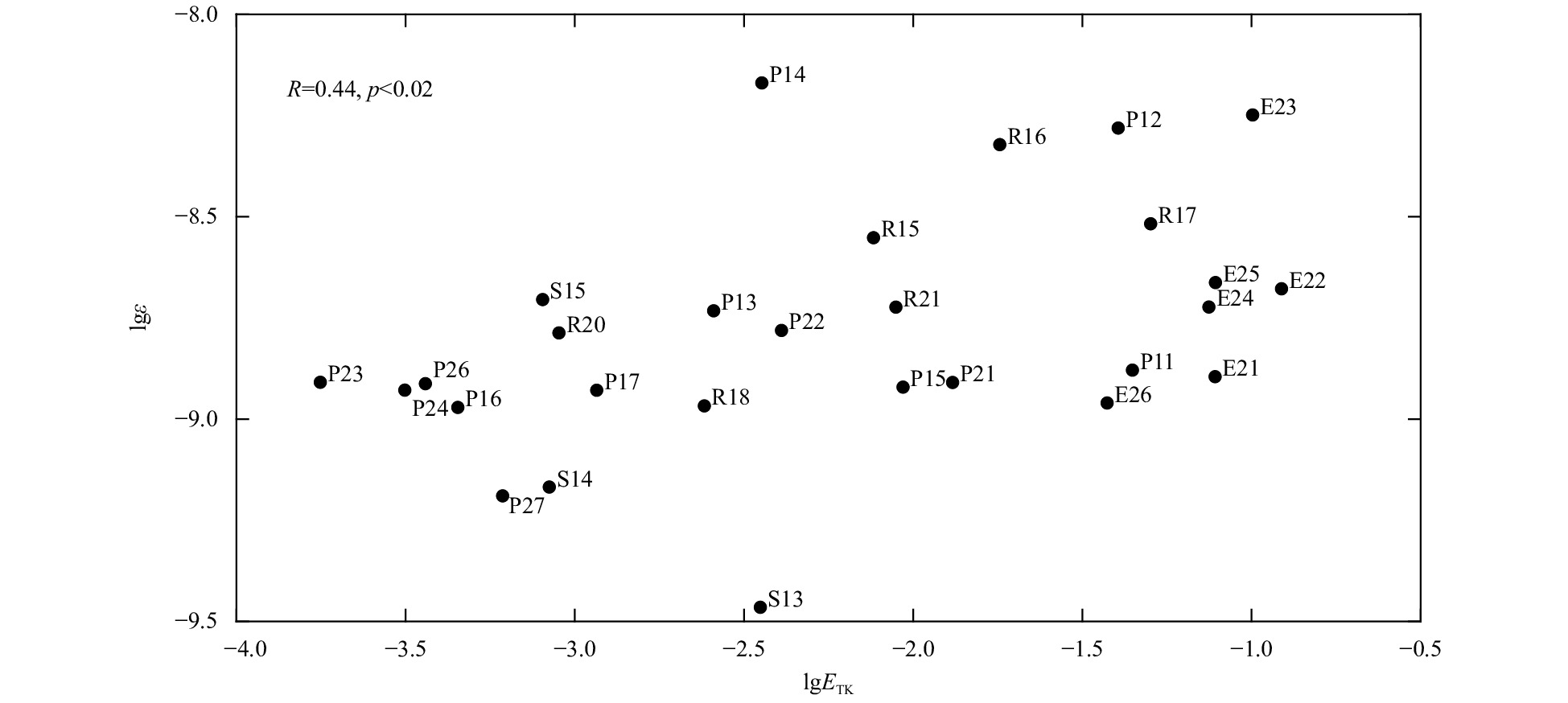
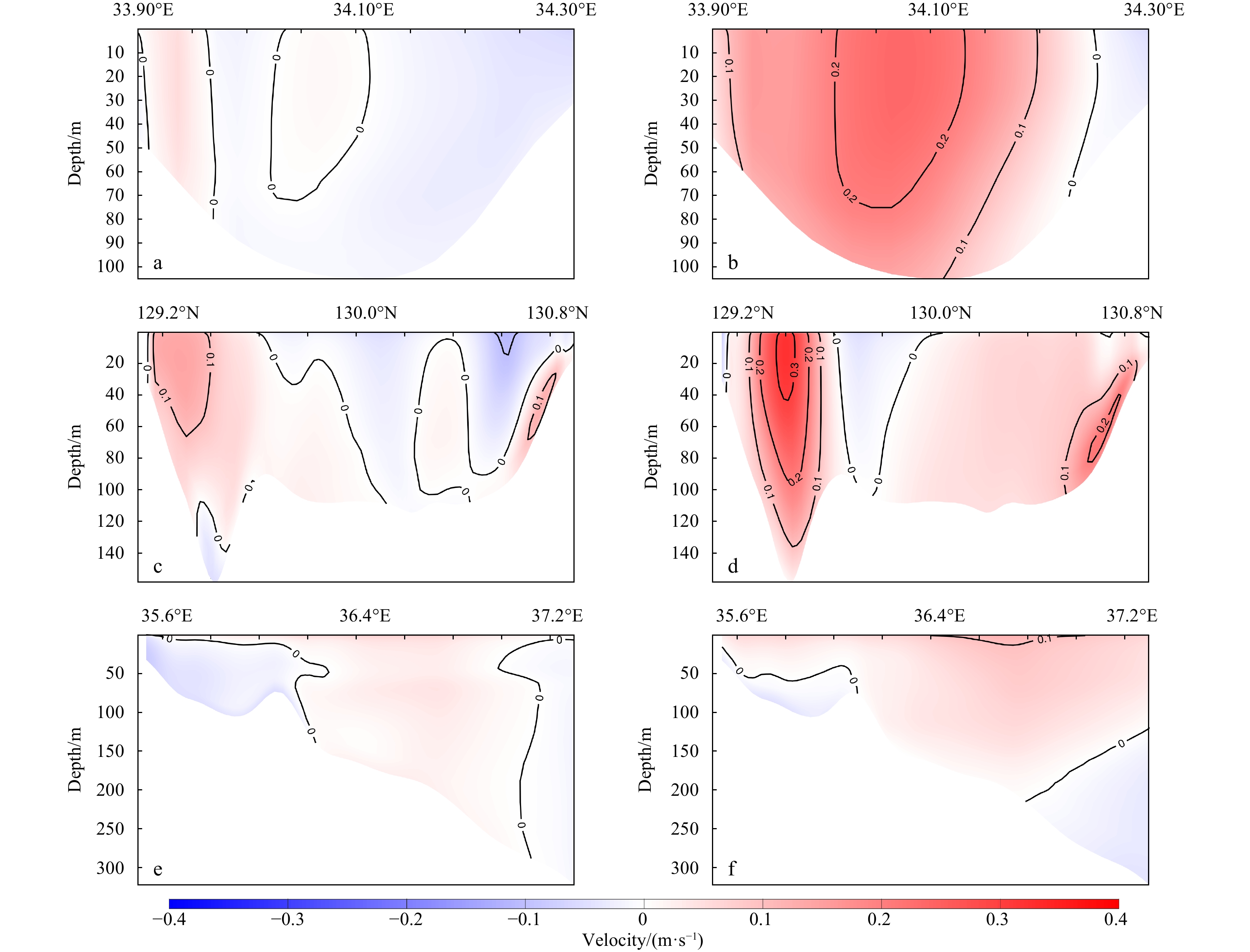
Oceanic vertical mixing of the lower halocline water (LHW) in the Chukchi Borderland and Mendeleyev Ridge was studied based on in situ hydrographic and turbulent observations. The depth-averaged turbulent dissipation rate of LHW demonstrates a clear topographic dependence, with a mean value of 1.2×10⁻⁹ W/kg in the southwest of Canada Basin, 1.5×10⁻⁹ W/kg in the Mendeleyev Abyssal Plain, 2.4×10⁻⁹ W/kg on the Mendeleyev Ridge, and 2.7×10⁻⁹ W/kg on the Chukchi Cap. Correspondingly, the mean depth-averaged vertical heat flux of the LHW is 0.21 W/m2 in the southwest Canada Basin, 0.30 W/m2 in the Mendeleyev Abyssal Plain, 0.39 W/m2 on the Mendeleyev Ridge, and 0.46 W/m2 on the Chukchi Cap. However, in the presence of Pacific Winter Water, the upward heat released from Atlantic Water through the lower halocline can hardly contribute to the surface ocean. Further, the underlying mechanisms of diapycnal mixing in LHW—double diffusion and shear instability—was investigated. The mixing in LHW where double diffusion were observed is always relatively weaker, with corresponding dissipation rate ranging from 1.01×10⁻⁹ W/kg to 1.57×10⁻⁹ W/kg. The results also show a strong correlation between the depth-average dissipation rate and strain variance in the LHW, which indicates a close physical linkage between the turbulent mixing and internal wave activities. In addition, both surface wind forcing and semidiurnal tides significantly contribute to the turbulent mixing in the LHW.
Effects of the seasonal variation in chlorophyll concentration on sea surface temperature in the global ocean
Jinfeng Ma, Hailong Liu, Pengfei Lin, Haigang Zhan
2021, 40(11): 50-61. doi: 10.1007/s13131-021-1765-7
Abstract:
The effects of biological heating on the upper-ocean temperature of the global ocean are investigated using two ocean-only experiments forced by prescribed atmospheric fields during 1990–2007, on with fixed constant chlorophyll concentration, and the other with seasonally varying chlorophyll concentration. Although the existence of high chlorophyll concentrations can trap solar radiation in the upper layer and warm the surface, cooling sea surface temperature (SST) can be seen in some regions and seasons. Seventeen regions are selected and classified according to their dynamic processes, and the cooling mechanisms are investigated through heat budget analysis. The chlorophyll-induced SST variation is dependent on the variation in chlorophyll concentration and net surface heat flux and on such dynamic ocean processes as mixing, upwelling and advection. The mixed layer depth is also an important factor determining the effect. The chlorophyll-induced SST warming appears in most regions during the local spring to autumn when the mixed layer is shallow, e.g., low latitudes without upwelling and the mid-latitudes. Chlorophyll-induced SST cooling appears in regions experiencing strong upwelling, e.g., the western Arabian Sea, west coast of North Africa, South Africa and South America, the eastern tropical Pacific Ocean and the Atlantic Ocean, and strong mixing (with deep mixed layer depth), e.g., the mid-latitudes in winter.
Frequent central Pacific La Niña events may accelerate Arctic warming since the 1980s
Jing Li, Lin Mu, Linhao Zhong
2021, 40(11): 62-69. doi: 10.1007/s13131-021/1843-x
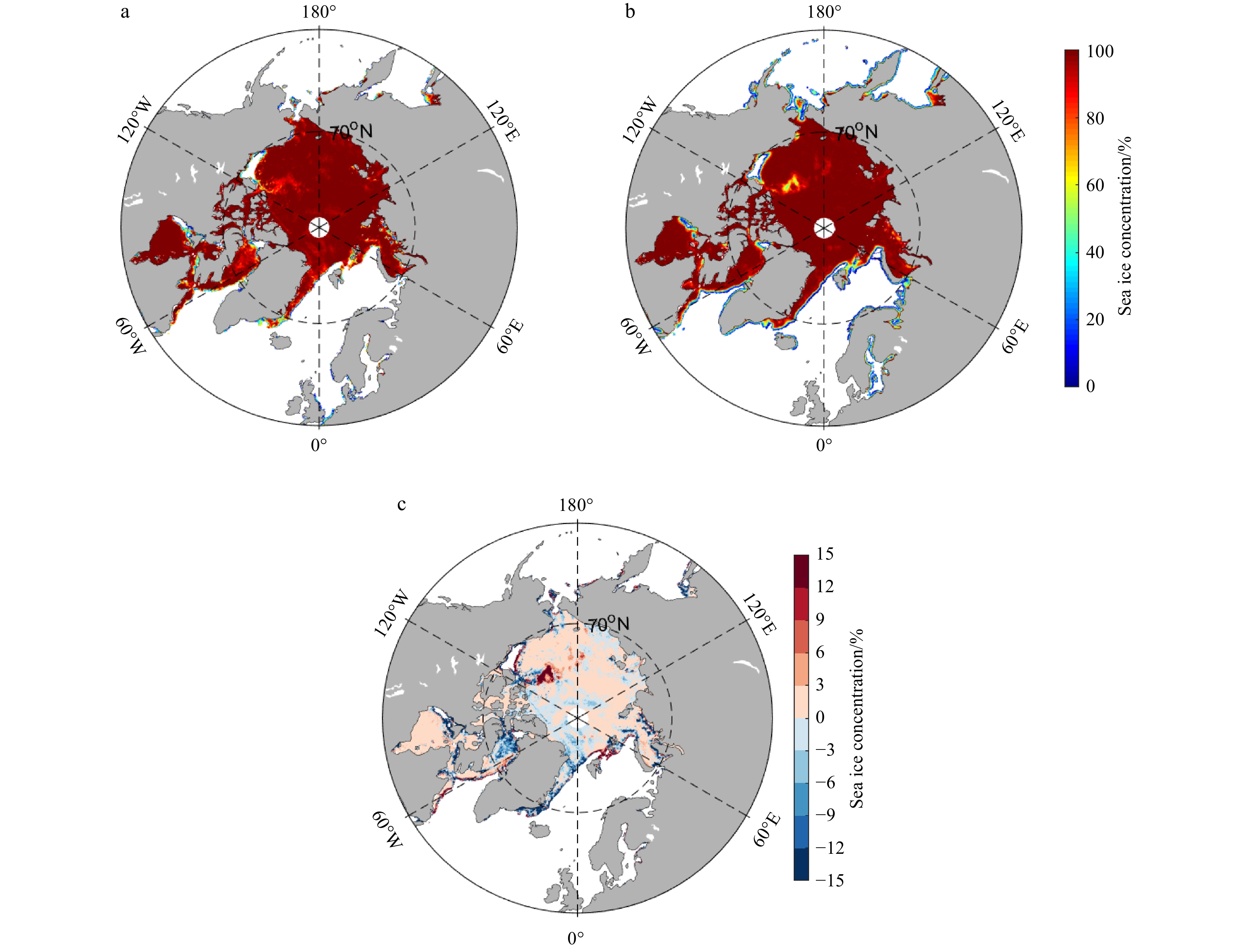
Abstract:
Including significant warming trend, Arctic climate changes also exhibit strong interannual variations in various fields, which is suggested to be related to El Niño and Southern Oscillation (ENSO) events. Previous studies have demonstrated the different impacts on the Arctic of central Pacific (CP) and eastern Pacific (EP) ENSO events, and suggested these impacts are largely of opposite sign for ENSO warm and cold phases. Our results illustrate asymmetrical changes for the cold and warm ENSO events, especially for the La Niña events. Compared to the past frequent basin-wide cooling La Niña events, since the 1980s the cooling center for the La Niña event has strengthened and moved westward along with the increasing frequency for the canonical and CP La Niña events. Contrary to the basin-wide cooling and canonical La Niña events, the frequent CP La Niña events induce significant warming from the Beaufort Sea to Greenland via the convection center moving northward over the western Pacific. Observation analysis and numerical experiments both suggest that the changes in La Niña type may also accelerate Arctic warming.
Interannual variability in the sea surface cooling induced by tropical cyclones in the South China Sea
Juan Ouyang, Chunhua Qiu, Zhenhui Yi, Dongxiao Wang, Danyi Su, Hong Liang, Zihao Yang
2021, 40(11): 70-78. doi: 10.1007/s13131-021-1870-7
Abstract:
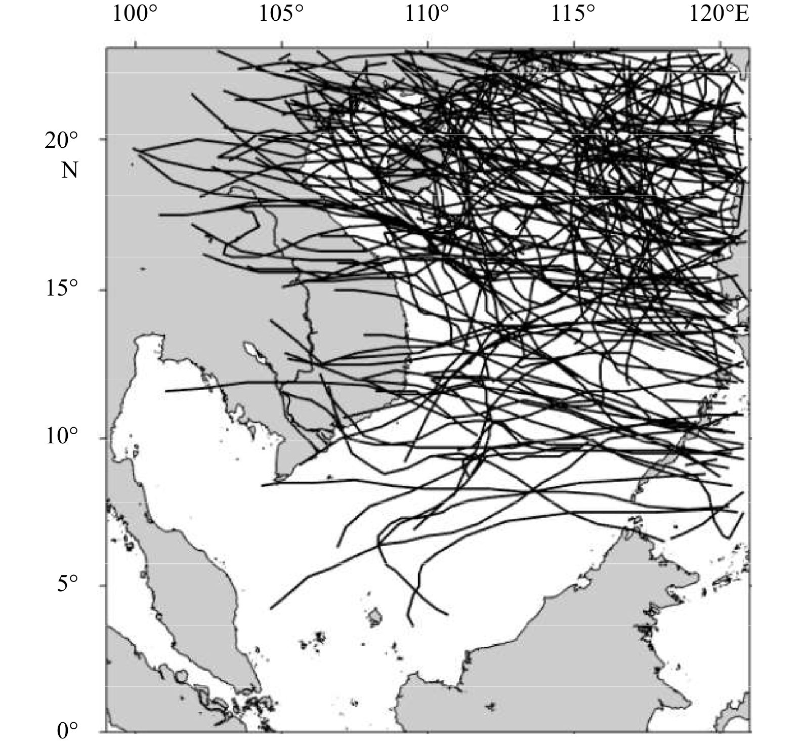
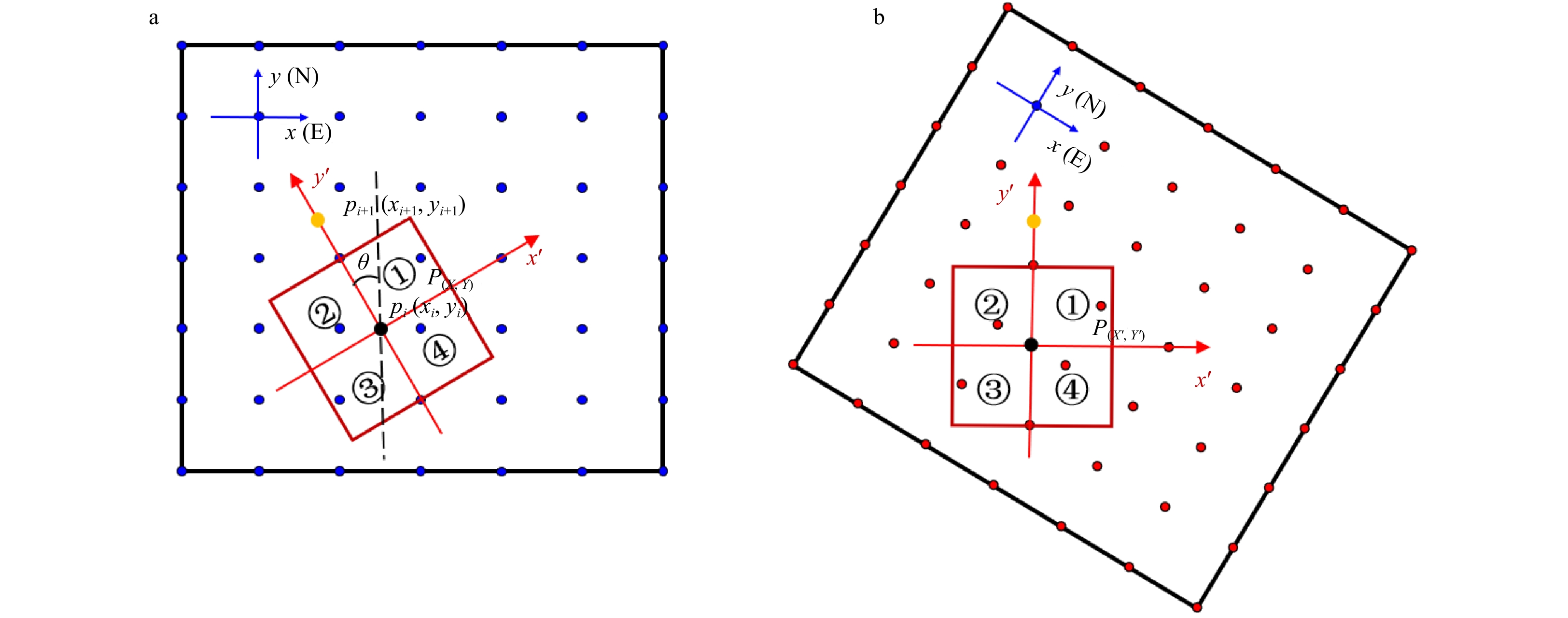
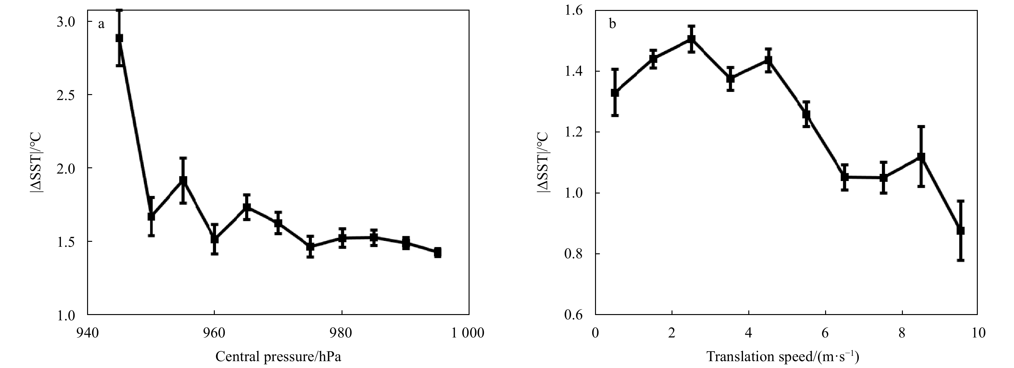
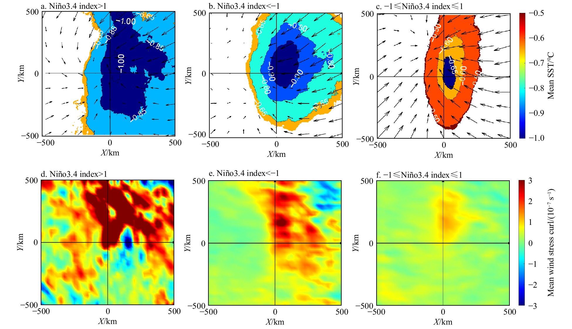
Sea surface cooling induced by tropical cyclones (TCs) is an important component of air-sea interactions. Using coordinate transformation and composite analysis methods, we examined the interannual variability in TC-induced sea surface cooling (TCSSC) in the South China Sea (SCS). The frequency of surface cooling cases was over 86% and that of surface warming cases was less than 14%. The magnitude of TCSSC was defined as the absolute value of TCSSC. The maximum magnitude of TCSSC occurred on the right side of the TC track, and the mean magnitude of TCSSC decreased by 0.04°C/a from 2006 to 2018. The interannual variability in TCSSC was highly correlated with the TC translation speed and pre-TC mixed layer depth. Notably, TCSSC got enhanced in El Niño years of 2007, 2010, and 2015. The El Niño types were suggested to determine the occurring periods of strong TCSSC via controlling the positions of SCS anticyclones, which brought pre-TC shallow mixed layer and caused strong TCSSC via vertical mixing process during El Niño events. To quantify how the anticyclone influences TCSSC, we need to use mixed layer heat balances model in the next study.
Influences of the Great Whirl on surface chlorophyll a concentration off the Somali Coast in 2017
Lingxing Dai, Bing Han, Shilin Tang, Chuqun Chen, Yan Du
2021, 40(11): 79-86. doi: 10.1007/s13131-021-1740-3
Abstract:
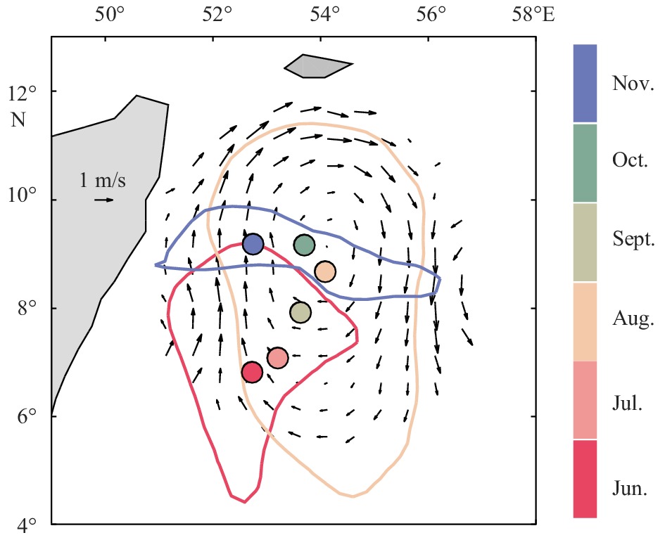
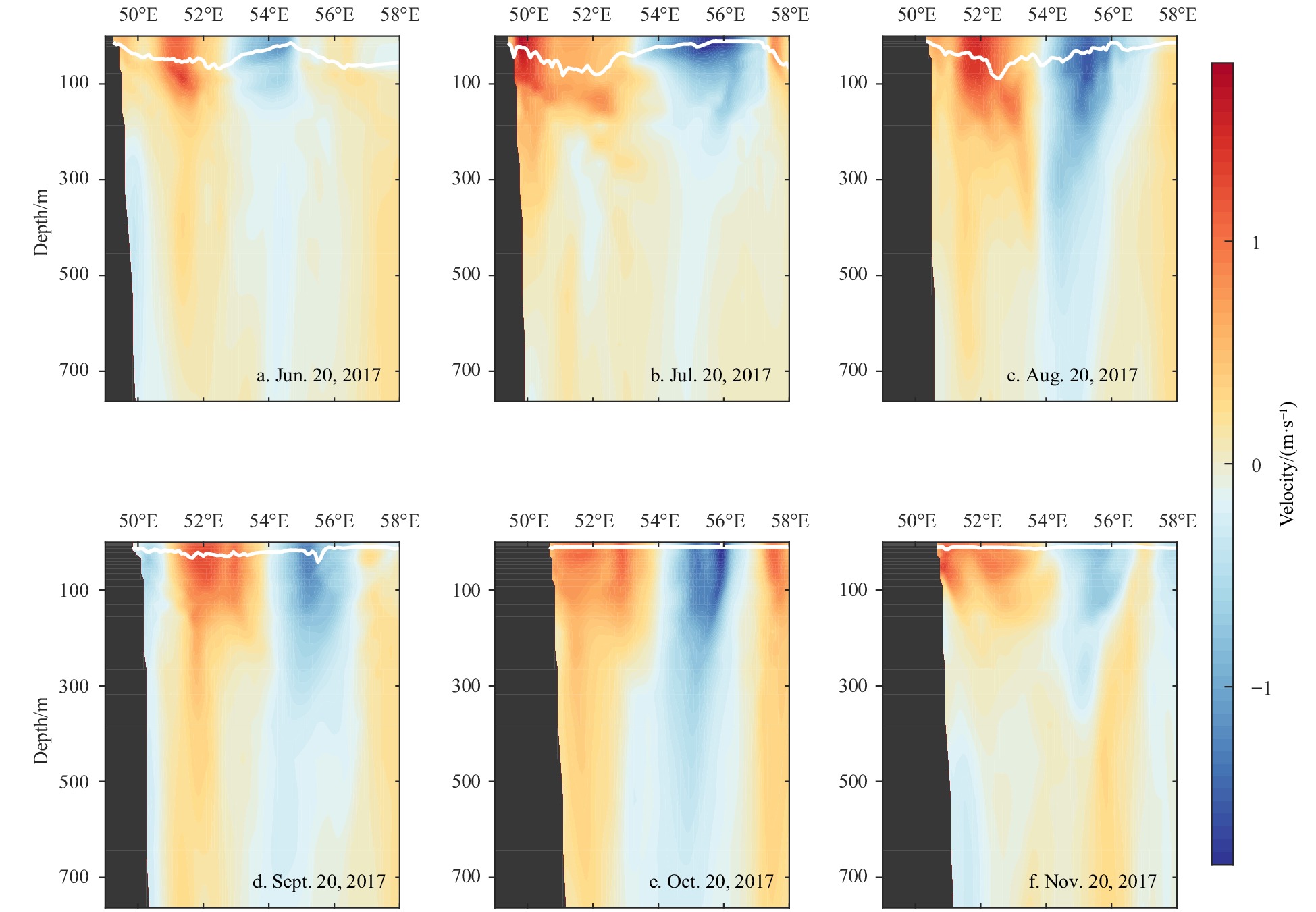
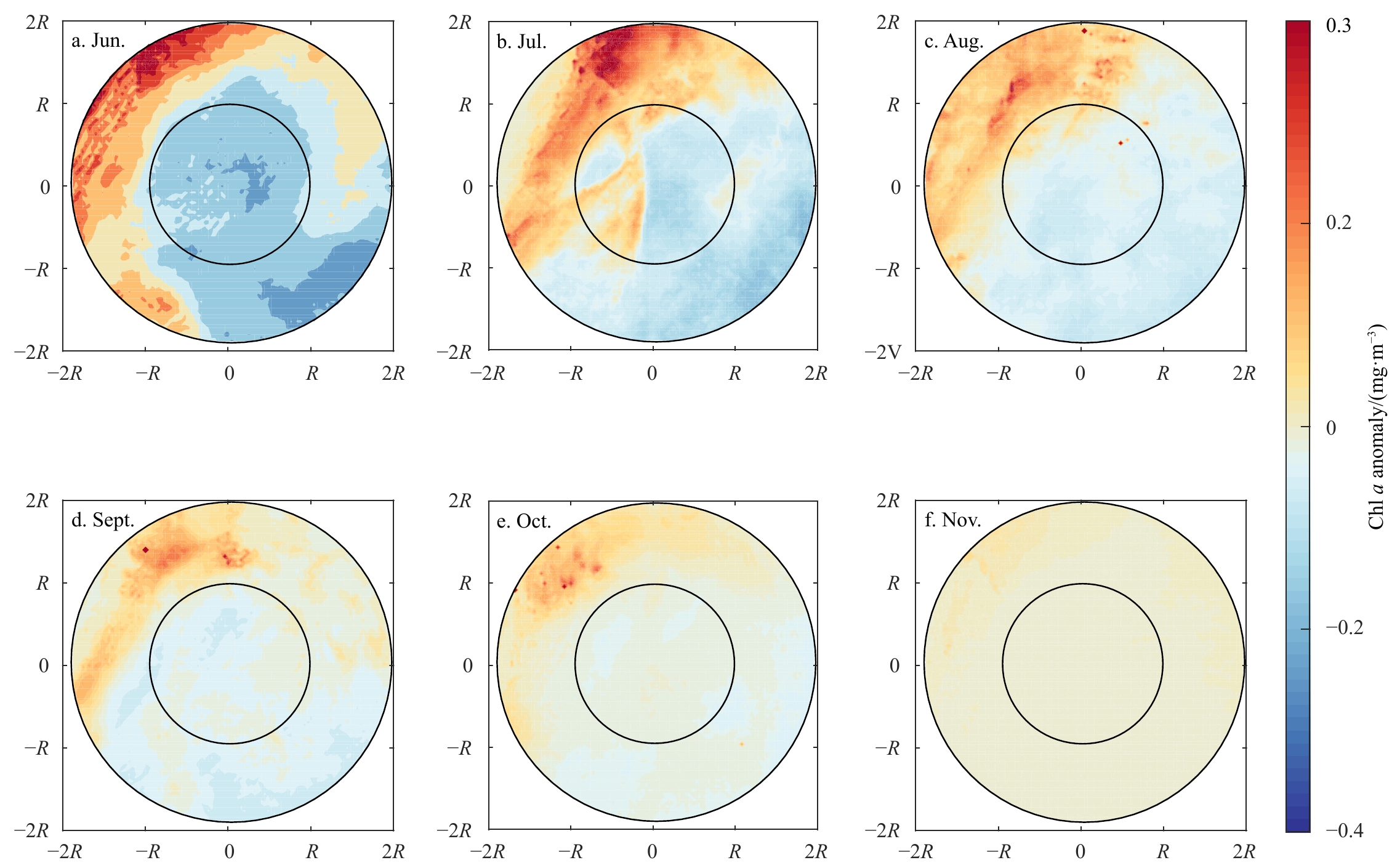
The general features of the Great Whirl (GW) off the Somali Coast in 2017 and its influences on chlorophyll a (Chl a) concentration were studied by using satellite data and model outputs. Results show that GW, which initiated at 7°N, 53°E on June 13, had a lifetime of 153 d with an average amplitude of 16 cm and an average radius of 205 km. After the formation of GW, the concentration of Chl a in the interior of GW showed a downward trend throughout its life cycle, except in early July and mid-October. In early July, the Chl a blooms in the interior of GW were attributed to the combined effect of three processes. They are eddy horizontal transportation, the deepening of the mixed layer caused by the monsoon and eddy pumping, and the upward transportation of nutrients caused by eddy-induced Ekman pumping. In October, the Chl a blooms were probably due to the weakening of GW. During the period, water exchange occurred more frequently across the eddy, thus phytoplanktons were imported into the interior of GW.
Recent improvements to the physical model of the Bohai Sea, the Yellow Sea and the East China Sea Operational Oceanography Forecasting System
Ang Li, Xueming Zhu, Yunfei Zhang, Shihe Ren, Miaoyin Zhang, Ziqing Zu, Hui Wang
2021, 40(11): 87-103. doi: 10.1007/s13131-021-1840-0
Abstract:
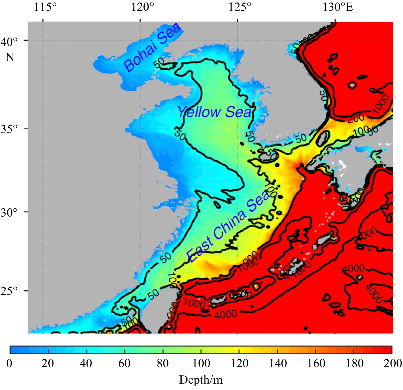
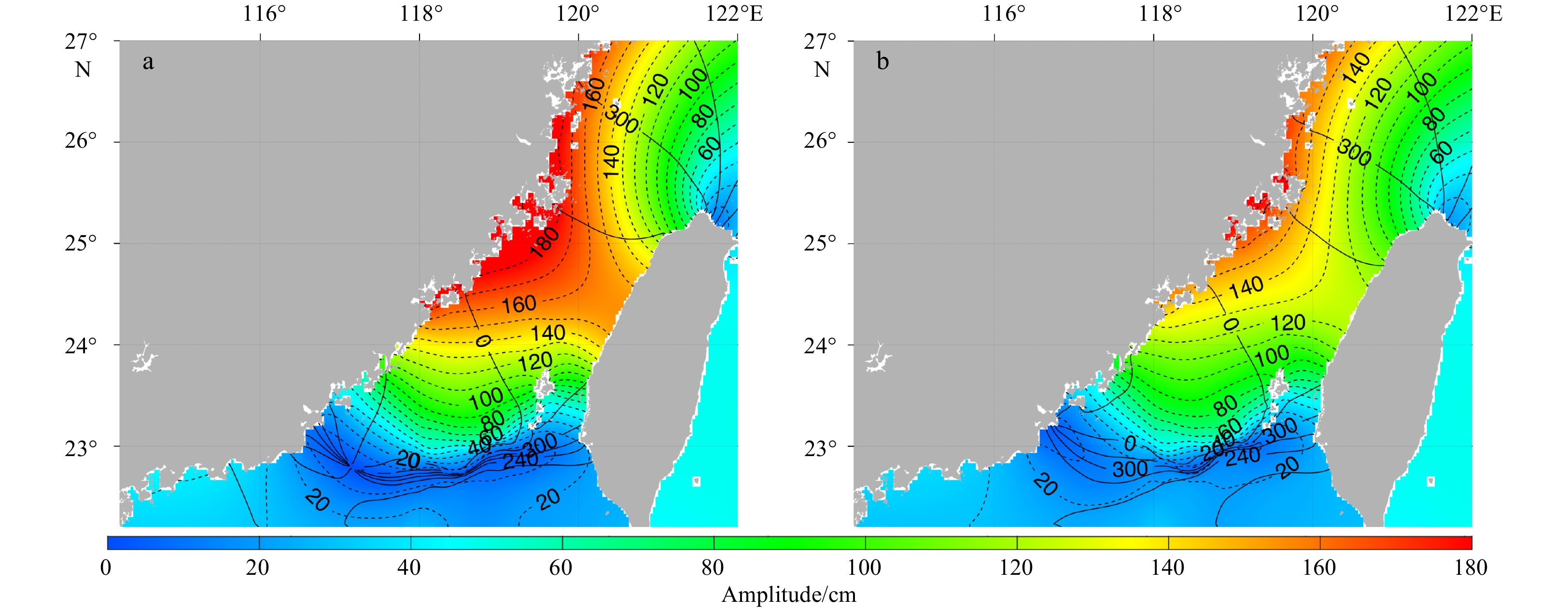
In order to satisfy the increasing demand for the marine forecasting capacity, the Bohai Sea, the Yellow Sea and the East China Sea Operational Oceanography Forecasting System (BYEOFS) has been upgraded and improved to Version 2.0. Based on the Regional Ocean Modeling System (ROMS), a series of comparative experiments were conducted during the improvement process, including correcting topography, changing sea surface atmospheric forcing mode, adjusting open boundary conditions, and considering atmospheric pressure correction. (1) After the topography correction, the volume transport and meridional velocity maximum of Yellow Sea Warm Current increase obviously and the unreasonable bending of its axis around 36.1°N, 123.5°E disappears. (2) After the change of sea surface forcing mode, an effective negative feedback mechanism is formed between predicted sea surface temperature (SST) by the ocean model and sea surface radiation fluxes fields. The simulation errors of SST decreased significantly, and the annual average of root-mean-square error (RMSE) decreased by about 18%. (3) The change of the eastern lateral boundary condition of baroclinic velocity from mixed Radiation-Nudging to Clamped makes the unreasonable westward current in Tsushima Strait disappear. (4) The adding of mean sea level pressure correction option which forms the mean sea level gradient from the Bohai Sea and the Yellow Sea to the western Pacific in winter and autumn is helpful to increasing the fluctuation of SLA and outflow of the Yellow Sea when the cold high air pressure system controls the Yellow Sea area.
Multi-step ahead short-term predictions of storm surge level using CNN and LSTM network
Bao Wang, Shichao Liu, Bin Wang, Wenzhou Wu, Jiechen Wang, Dingtao Shen
2021, 40(11): 104-118. doi: 10.1007/s13131-021-1763-9
Abstract:
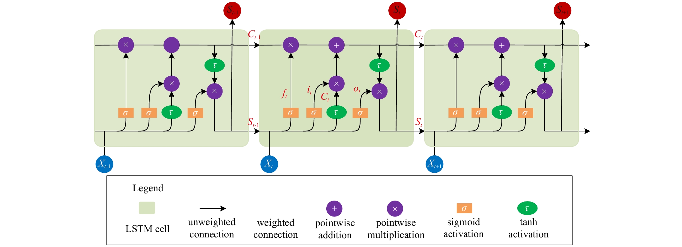
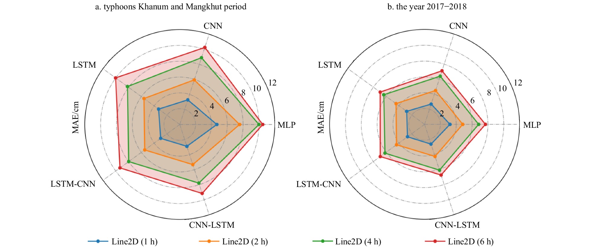
Storm surges pose significant danger and havoc to the coastal residents’ safety, property, and lives, particularly at offshore locations with shallow water levels. Predictions of storm surges with hours of warning time are important for evacuation measures in low-lying regions and coastal management plans. In addition to experienced predictions and numerical models, artificial intelligence (AI) techniques are also being used widely for short-term storm surge prediction owing to their merits in good level of prediction accuracy and rapid computations. Convolutional neural network (CNN) and long short-term memory (LSTM) are two of the most important models among AI techniques. However, they have been scarcely utilised for surge level (SL) forecasting, and combinations of the two models are even rarer. This study applied CNN and LSTM both individually and in combination towards multi-step ahead short-term storm surge level prediction using observed SL and wind information. The architectures of the CNN, LSTM, and two sequential techniques of combining the models (LSTM–CNN and CNN–LSTM) were constructed via a trial-and-error approach and knowledge obtained from previous studies. As a case study, 11 a of hourly observed SL and wind data of the Xiuying Station, Hainan Province, China, were organised as inputs for training to verify the feasibility and superiority of the proposed models. The results show that CNN and LSTM had evident advantages over support vector regression (SVR) and multilayer perceptron (MLP), and the combined models outperformed the individual models (CNN and LSTM), mostly by 4%–6%. However, on comparing the model computed predictions during two severe typhoons that resulted in extreme storm surges, the accuracy was found to improve by over 10% at all forecasting steps.
Mechanisms for the link between onset and duration of open water in the Kara Sea
Chunming Dong, Hongtao Nie, Xiaofan Luo, Hao Wei, Wei Zhao
2021, 40(11): 119-128. doi: 10.1007/s13131-021-1767-5
Abstract:
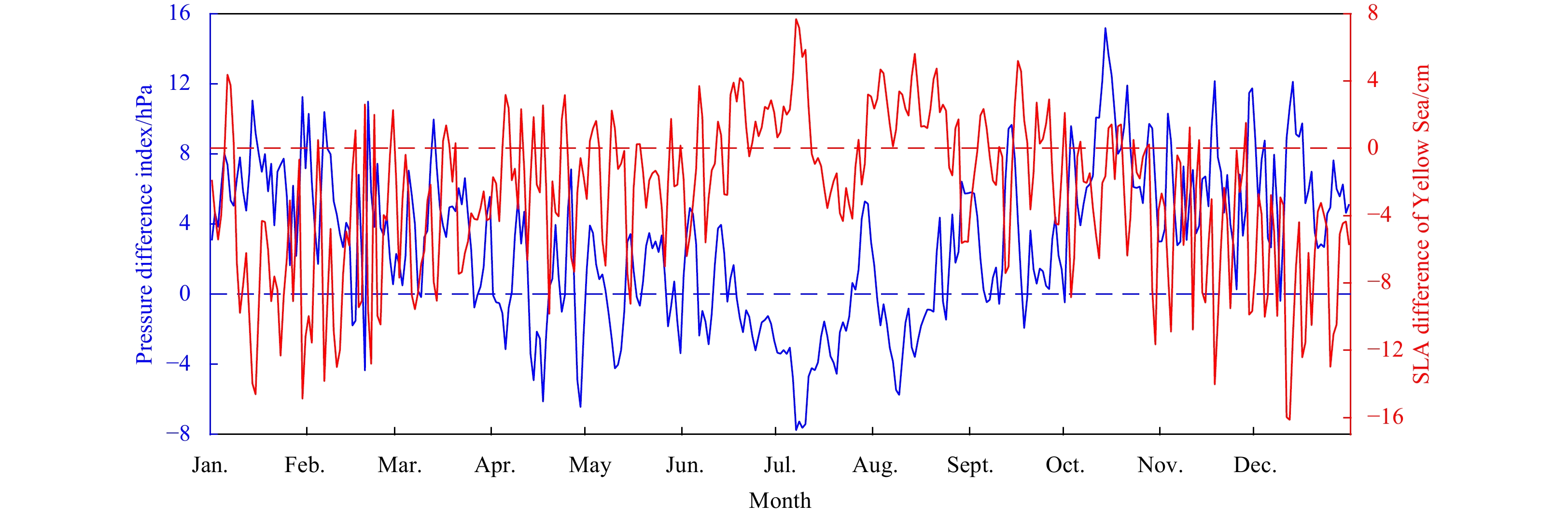
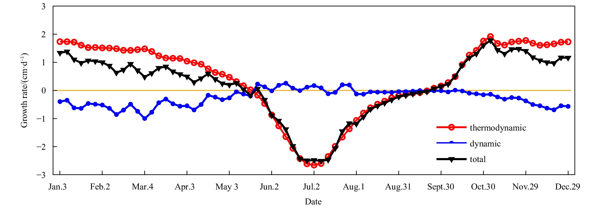
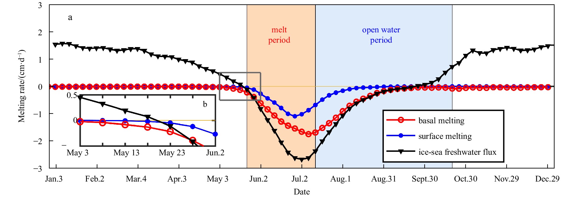
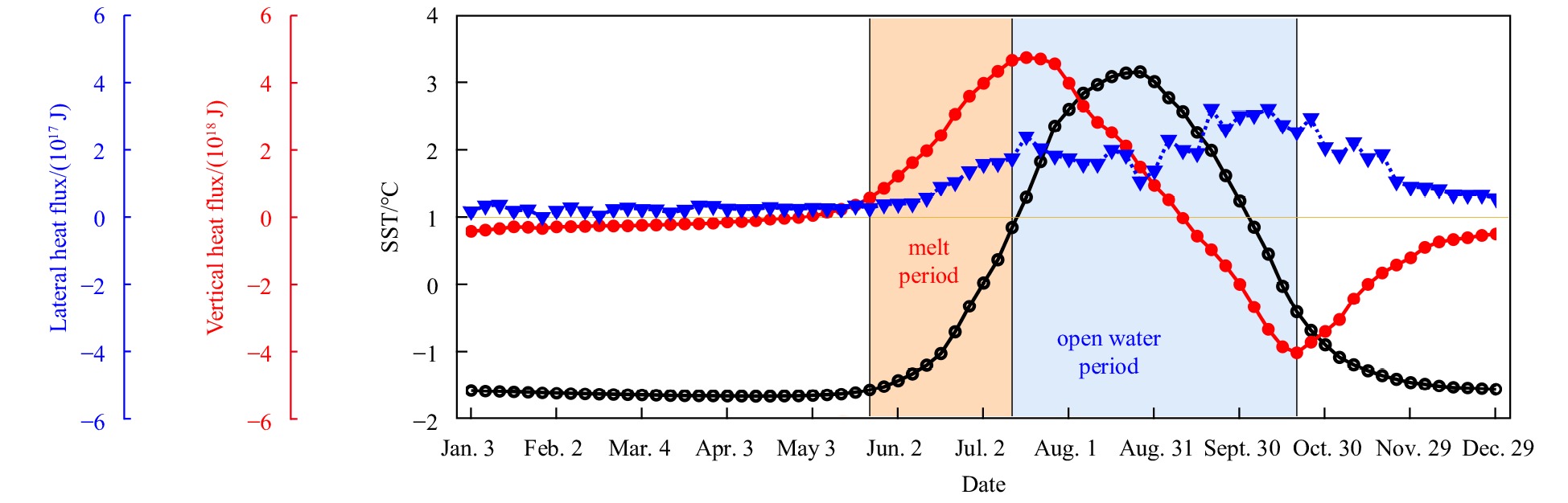
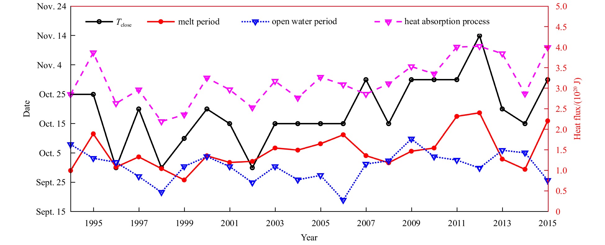
The sea ice conditions in the Kara Sea have important impacts on Arctic shipping, oil and gas production, and marine environmental changes. In this study, sea ice coverage (CR) less than 30% is considered as open water, its onset and end dates are defined as Topen and Tclose, respectively. The sea ice melt onset (Tmelt) is defined as the date when ice-sea freshwater flux initially changes from ice into the ocean. Satellite-based sea ice concentration (SIC) from 1989 to 2019 shows a negative correlation between Topen and Tclose (r = –0.77, p < 0.01) in the Kara Sea. This phenomenon is also obtained through analyzing the hindcast simulation from 1994 to 2015 by a coupled ocean and sea-ice model (NAPA1/4). The model results reveal that thermodynamics dominate the sea ice variations, and ice basal melt is greater than the ice surface melt. Heat budget estimation suggests that the heat flux is significant correlated with Topen (r = –0.95, p < 0.01) during the melt period (the duration of multi-year averaged Tmelt to Topen) influenced by the sea ice conditions. Additionally, this heat flux is also suggested to dominate the interannual variation of the heat input during the whole heat absorption process (r = 0.81, p < 0.01). The more heat input during this process leads to later Tclose (r = 0.77, p < 0.01). This is the physical basis of the negative correlation between Topen and Tclose. Therefore, the duration of open water can be predicted by Topen and thence support earlier planning of marine activities.
Wave-ice dynamical interaction: a numerical model and its application
Yang Zhang, Changsheng Chen, Guoping Gao, Jianhua Qi, Huichan Lin, Wei Yu, Liang Chang
2021, 40(11): 129-137. doi: 10.1007/s13131-021-1760-z
Abstract:
In this paper, an ice floe inner stress caused by the wave-induced bending moment is derived to estimate the stress failure of ice floe. The strain and stress failures are combined to establish a wave-induced ice yield scheme. We added ice stress and strain failure module in the Finite-Volume Community Ocean Model (FVCOM), which already includes module of ice-induced wave attenuation. Thus a fully coupled wave-ice dynamical interaction model is established based on the ice and wave modules of FVCOM. This model is applied to reproduce the ice and wave fields of the breakup events observed during the second Sea Ice Physics and Ecosystem Experiment (SIPEX-2) voyage. The simulation results show that by adopting the combined wave-induced ice yield scheme, the model can successfully predict the ice breakup events, which the strain failure model is unable to predict. By comparing the critical significant wave height deduced from strain and stress failure schemes, it is concluded that the ice breakup is caused by the strain failure when wave periods are shorter than a threshold value, while the stress failure is the main reason for the ice breakup when wave periods are longer than the threshold value. Neglecting either of these two ice-break inducement mechanisms could overestimate the ice floe size, and thus underestimate the velocity of the ice lateral melt and increase the error of simulation of polar ice extent.
Marine Geology
Geological characteristics of the Qiaoyue Seamount and associated ultramafic-hosted seafloor hydrothermal system (~52.1°E, Southwest Indian Ridge)
Yongjin Huang, Chunhui Tao, Jin Liang, Shili Liao, Yuan Wang, Dong Chen, Weifang Yang
2021, 40(11): 138-146. doi: 10.1007/s13131-021-1832-0
Abstract:
Hydrothermal vent incidence was once thought to be proportional to the spreading rate of the mid-ocean ridges (MORs). However, more and more studies have shown that the ultraslow-spreading ridges (e.g., Southwest Indian Ridge (SWIR)) have a relatively higher incidence of hydrothermal venting fields. The Qiaoyue Seamount (52.1°E) is located at the southern side of segment #25 of the SWIR, to the west of the Gallieni transform fault. The Chinese Dayang cruises conducted eight preliminary deep-towed surveys of hydrothermal activity in the area during 2009 and 2018. Here, through comprehensive analyses of the video and photos obtained by the deep-towed platforms, rock samples, and water column turbidity anomalies, a high-temperature, ultramafic-hosted hydrothermal system is predicted on the northern flank of the Qiaoyue Seamount. We propose that this hydrothermal system is most likely to be driven by gabboric intrusions. Efficient hydrothermal circulation channels appear against a backdrop of high rock permeability related to the detachment fault.
Petrogenesis and tectonic implication of lavas from the Yap Trench, western Pacific
Ling Chen, Limei Tang, Jichao Yang, Xiaohu Li, Wei Wang, Fengyou Chu, Jie Zhang
2021, 40(11): 147-161. doi: 10.1007/s13131-021-0185-y
Abstract:
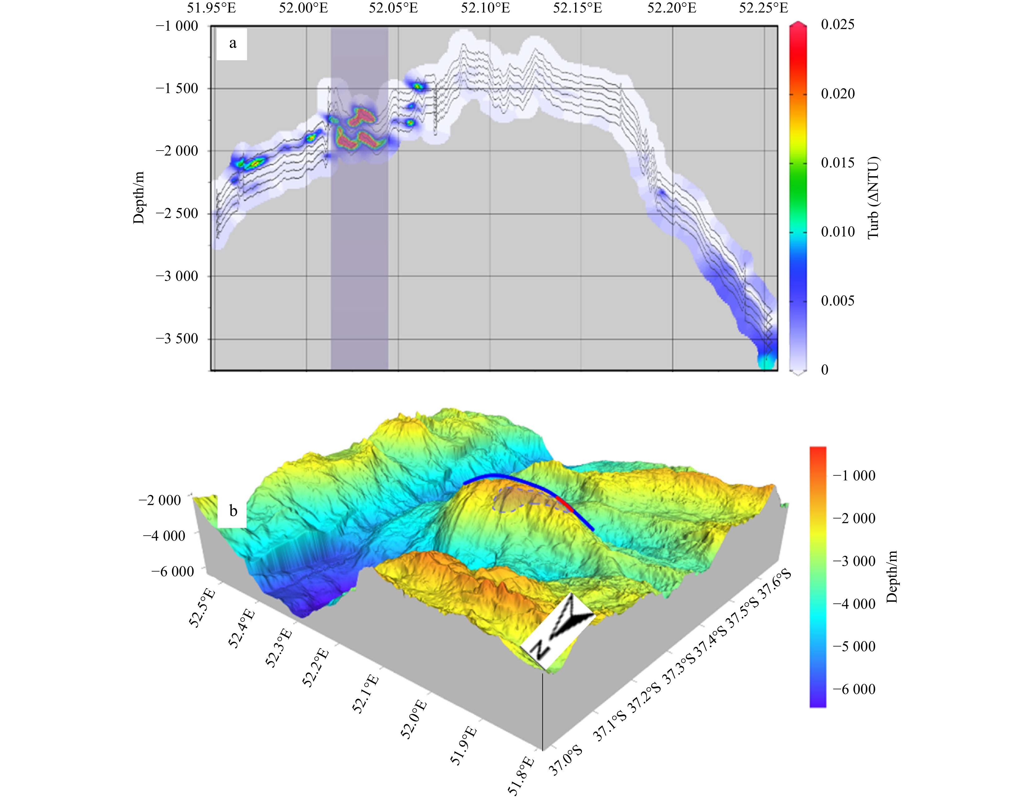
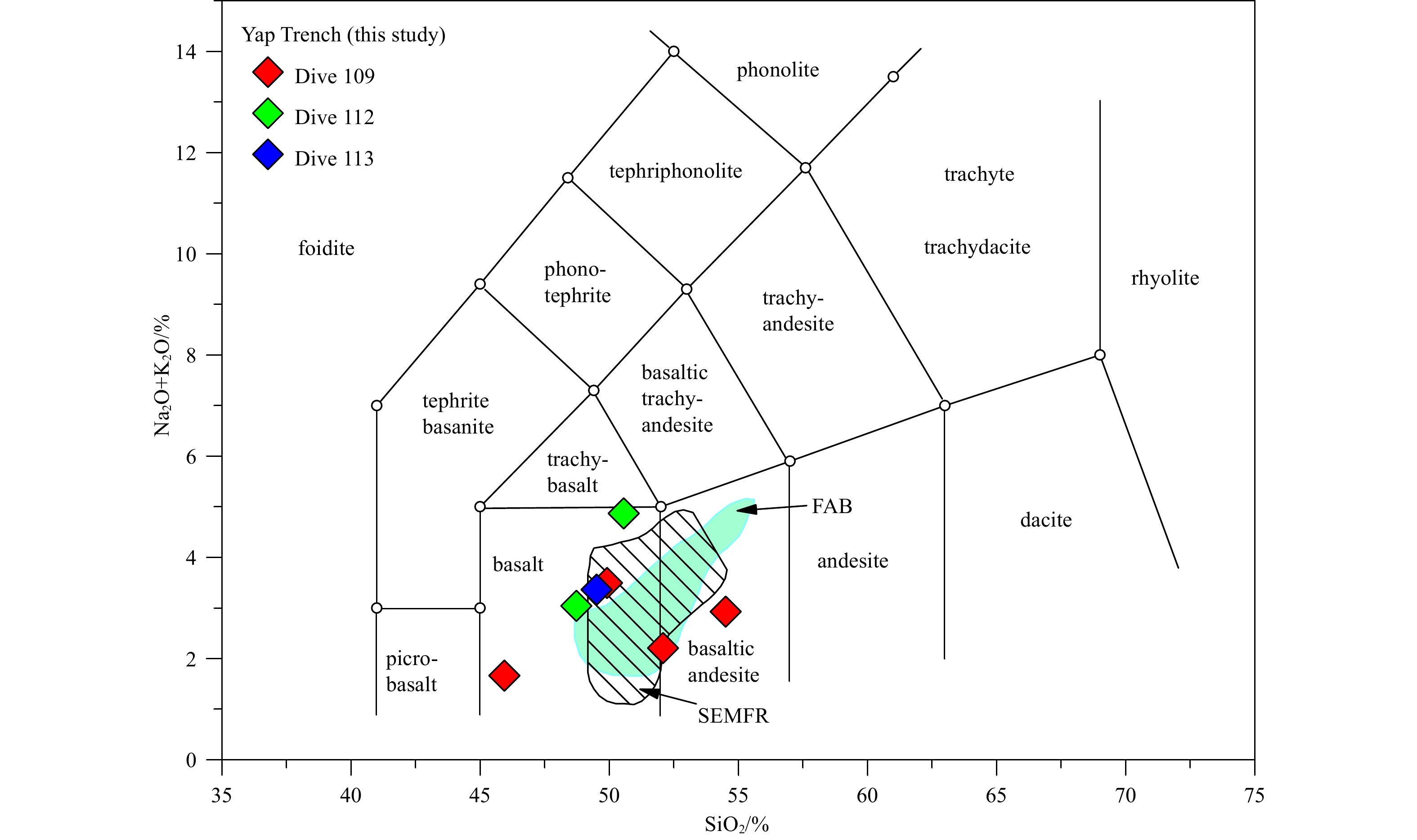
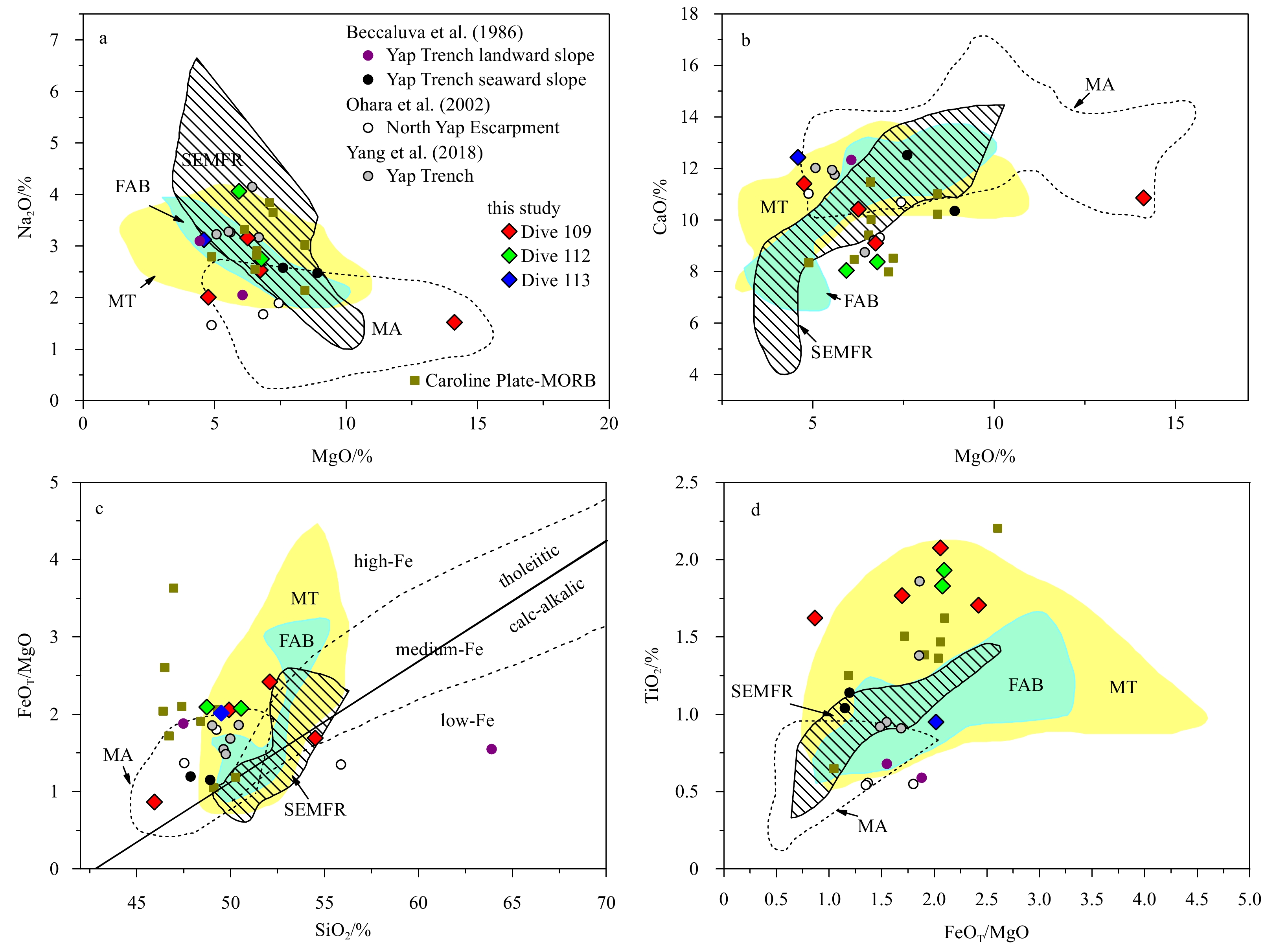
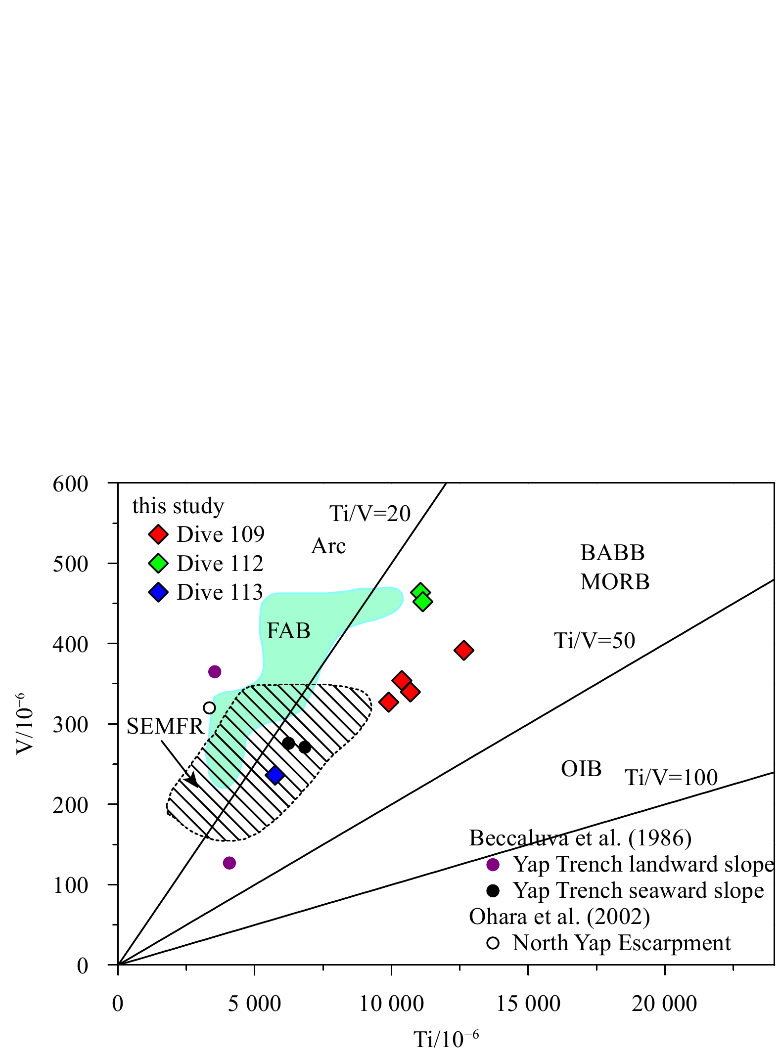
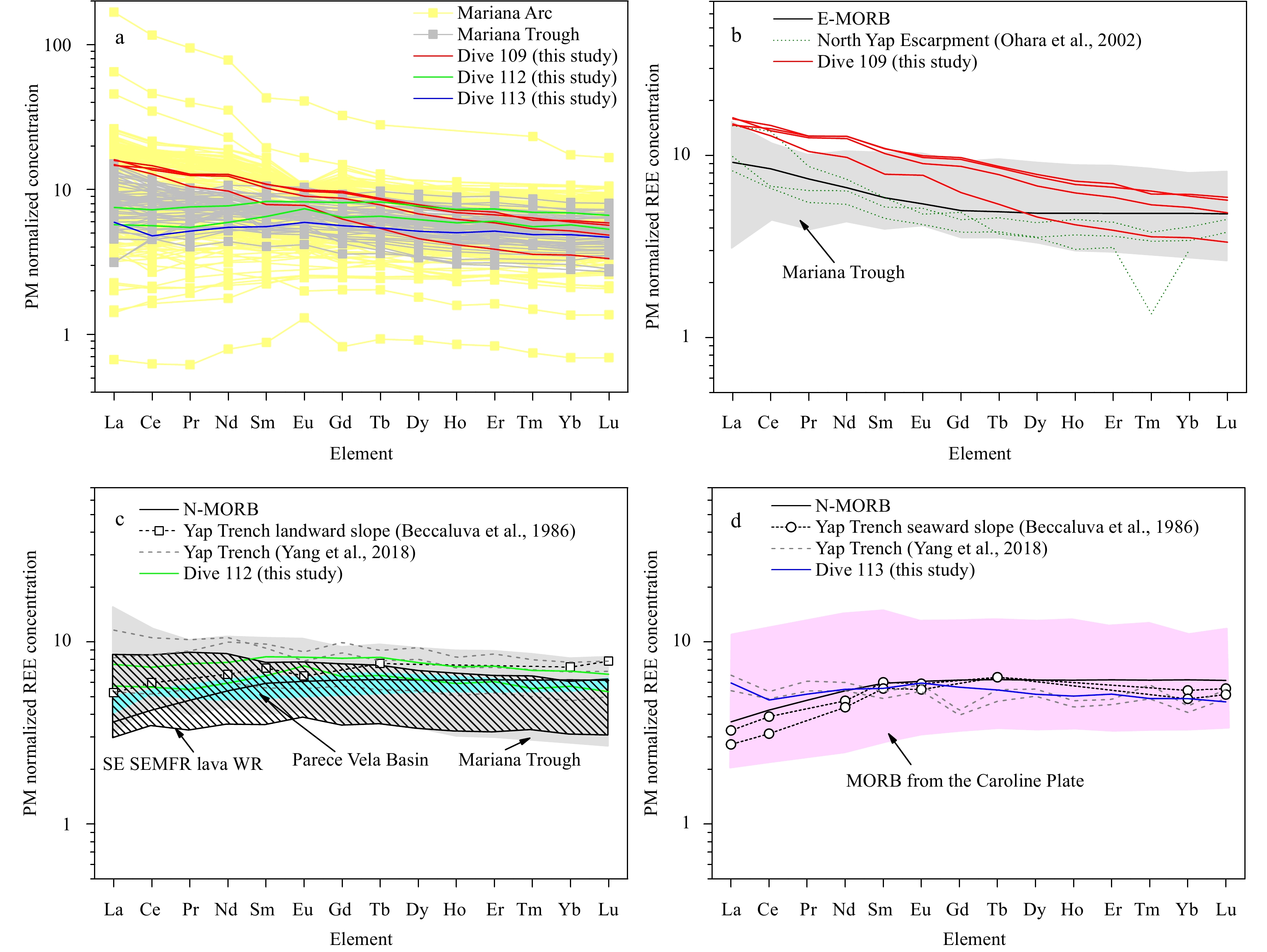
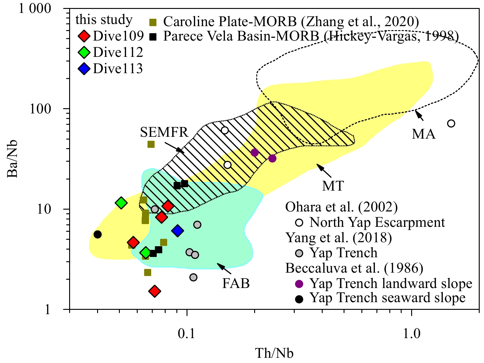
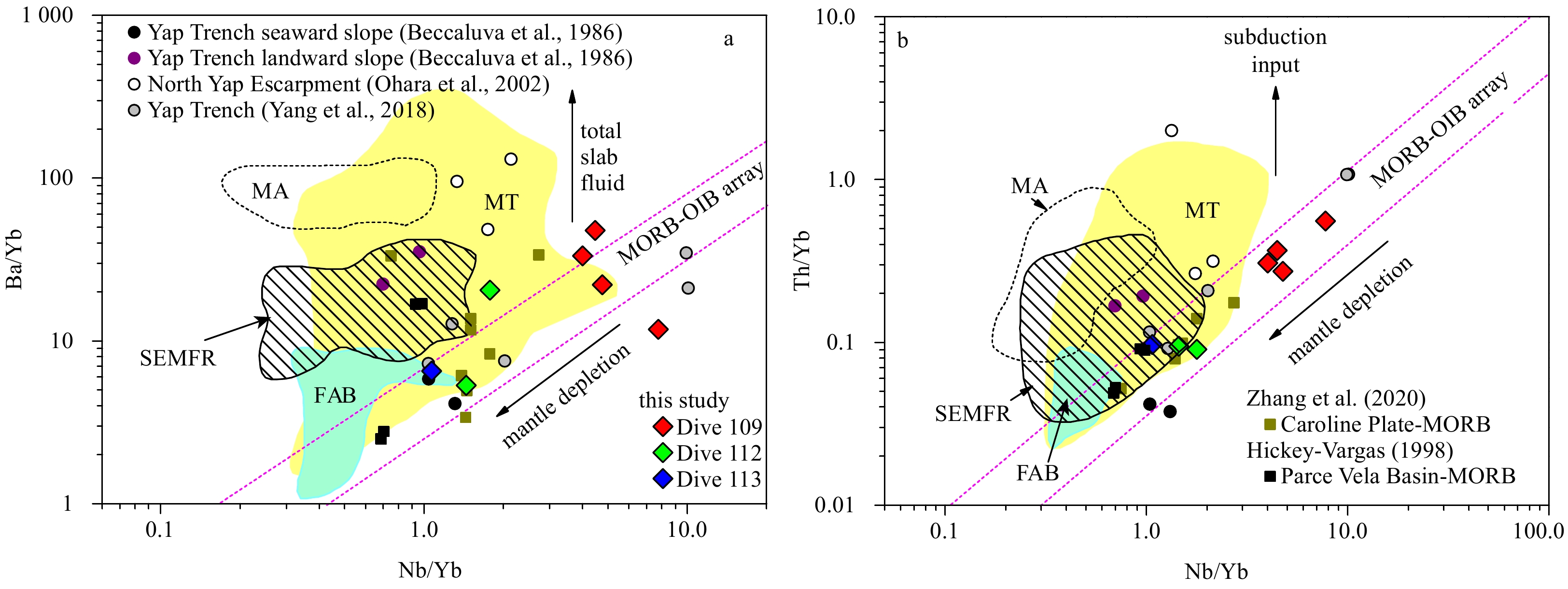
We present major and trace element data of lava recovered from the northern Yap Trench in the western Pacific and discuss their petrogenesis and tectonic implications within the framework of interactions between the Caroline Ridge and Yap Trench. Rocks were collected from both landward and seaward trench slopes and exhibited geochemical characteristics similar to backarc basin basalt (BABB) and mid-ocean ridge basalt (MORB), including high Fe content, tholeiitic affinity, high TiO2 value at a given FeOT/MgO ratio, Ti/V ratio between 20 and 50, low Ba/Nb ratio and Th/Nb ratio, and trace element patterns commonly displayed by BABB and MORB, which are distinct from arc lava. These rocks seem to have been generated during mantle upwelling and decompression melting at a spreading center. However, compared with typical forearc lava produced by seafloor spreading in the Mariana forearc region, such as the early Eocene forearc basalts and late Neogene forearc lava in the southernmost Mariana Trench, the Yap Trench lava is derived from a more fertile mantle and feature a more minor subduction component; thus, they cannot be the products of forearc mantle decompression melting. We suggest that the landward slope lava represents backarc basin crust that was overthrust onto the forearc lithosphere during the collision of the Caroline Ridge with the Yap Trench (20–25 Ma), which played a key role in the evolution of the Yap subduction system. Moreover, the seaward slope lava represents the subduction plate crust that accreted onto the deep trench during the collision. This collision event resulted in the cessation of Yap Arc magmatism; thus, the Yap Trench volcanic rocks (<25 Ma) previously suggested to be arc magma products may actually represent the nascent island arc lava with a lower subduction component than in the mature Mariana Arc lava.
Tracking historical storm records from high-barrier lagoon deposits on the southeastern coast of Hainan Island, China
Liang Zhou, Xiaomei Xu, Yaping Wang, Jianjun Jia, Yang Yang, Gaocong Li, Changliang Tong, Shu Gao
2021, 40(11): 162-175. doi: 10.1007/s13131-021-1833-z
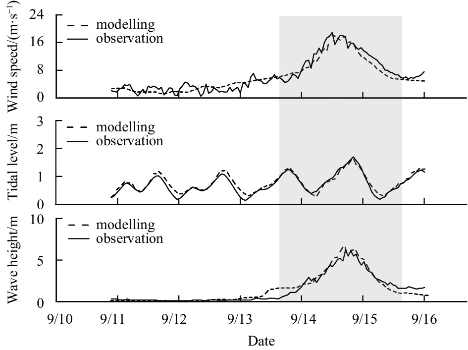
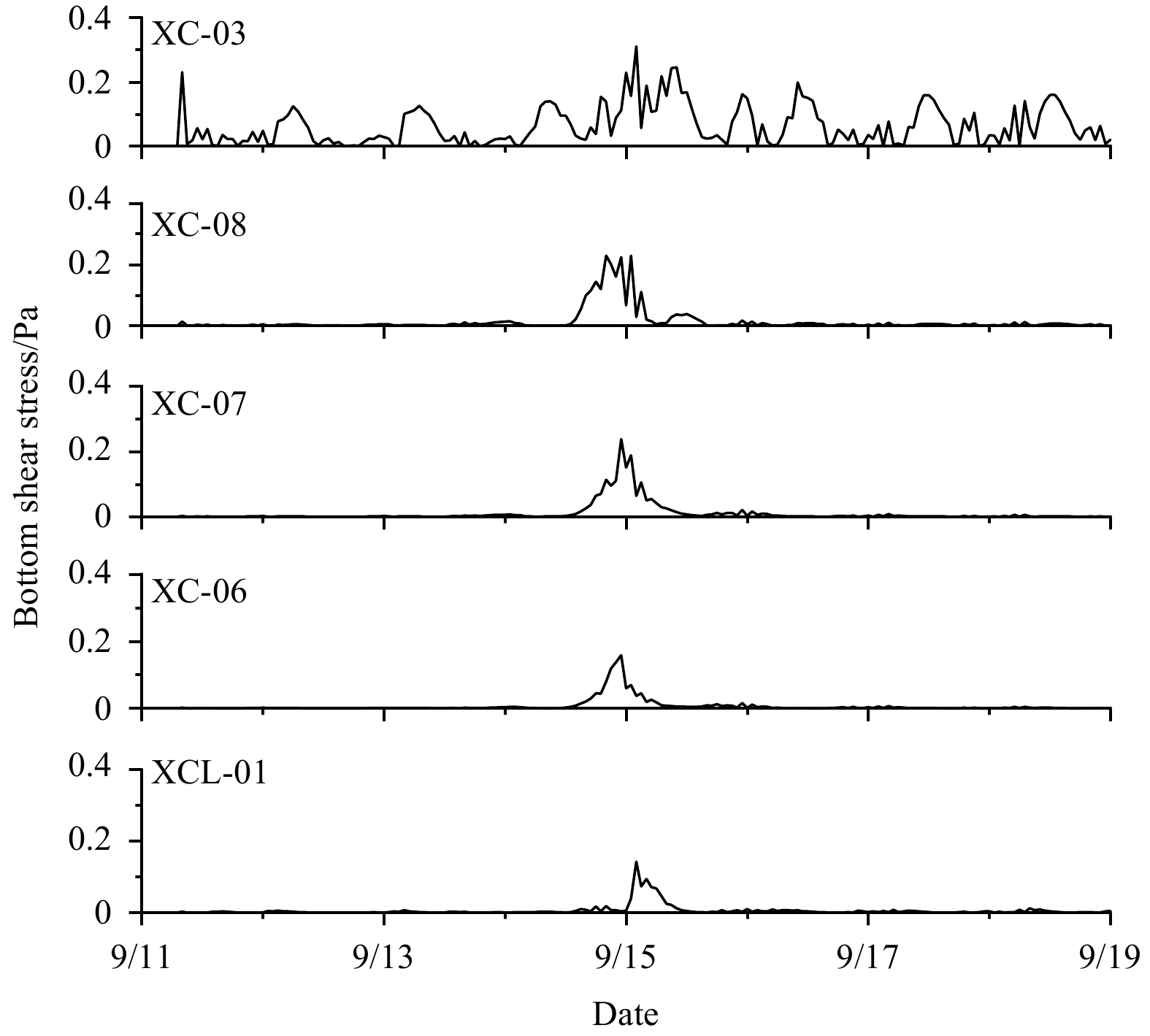
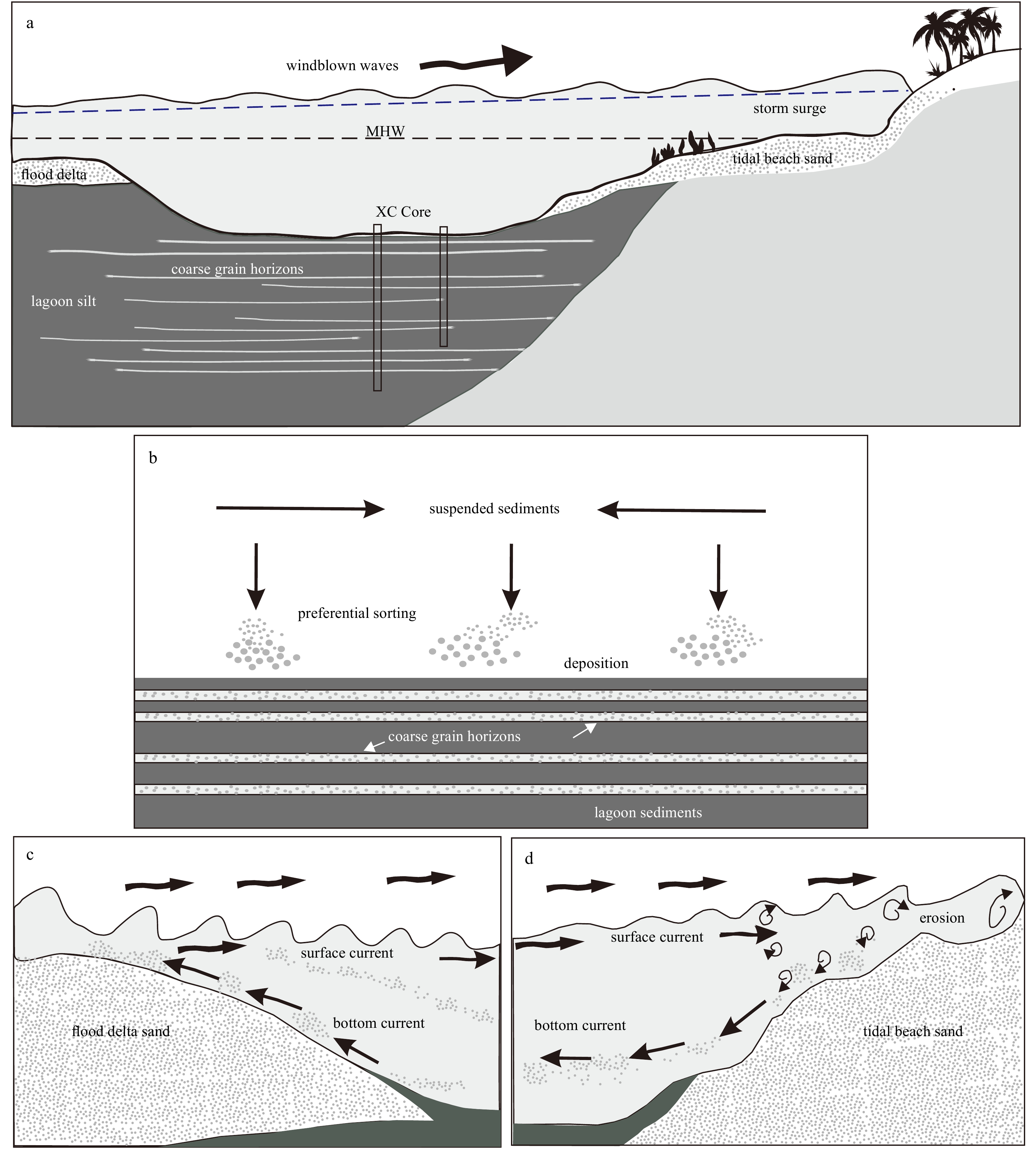
Abstract:
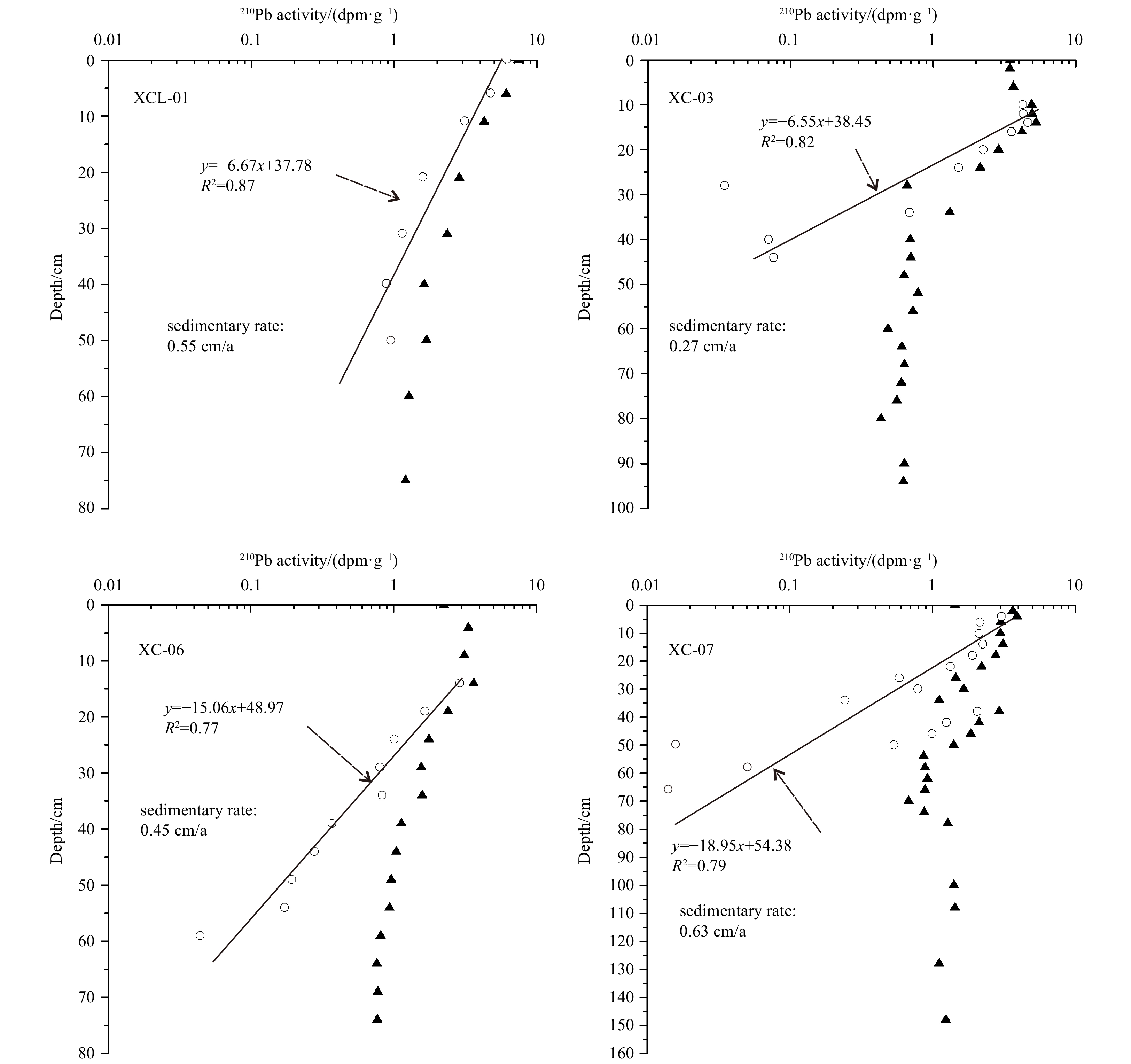
The relationship between storm activity and global warming remains uncertain. To better understand storm–climate relationships, coastal lagoon deposits are increasingly being investigated because they could provide high-resolution storm records long enough to cover past climate changes. However, site-specific sediment dynamics and high barriers may bias storm reconstructions. Here, we aimed to investigate these factors through the reconstruction of five distinct storm records (XCL-01, XC-03, XC-06, XC-07, XC-08) from different water depths in a lagoon with a high barrier (i.e., Xincun Lagoon of Hainan Island). Sediment cores were characterized using high-resolution grain size and XRF measurements, to identify storm events. These data were coupled with a numerical simulation to obtain bed shear stress data with high-spatial resolution to better understand storm-induced sediment transport mechanisms. 210Pb dating and Pb pollution chronostratigraphic markers indicated that the chronology of the storm deposit sequences of the cores span the period between 117 a and 348 a. The grain size and XRF results indicated numerous, highly variable and short-duration fluctuations, suggesting that storm-induced coarse-grained sediments were deposited at these core sites. The inconsistent storm events recorded in these cores suggest that these sites have different preservation potentials for storm deposits. However, the consistence between storm sediment records and historical documents for Core XCL-01 indicates that high-barrier lagoons could provide long-term storm event records with high preservation potential.
Marine Information Science
Arctic sea ice concentration retrieval using the DT-ASI algorithm based on FY-3B/MWRI data
Hairui Hao, Jie Su, Qian Shi, Lele Li
2021, 40(11): 176-188. doi: 10.1007/s13131-021-1839-6
Abstract:
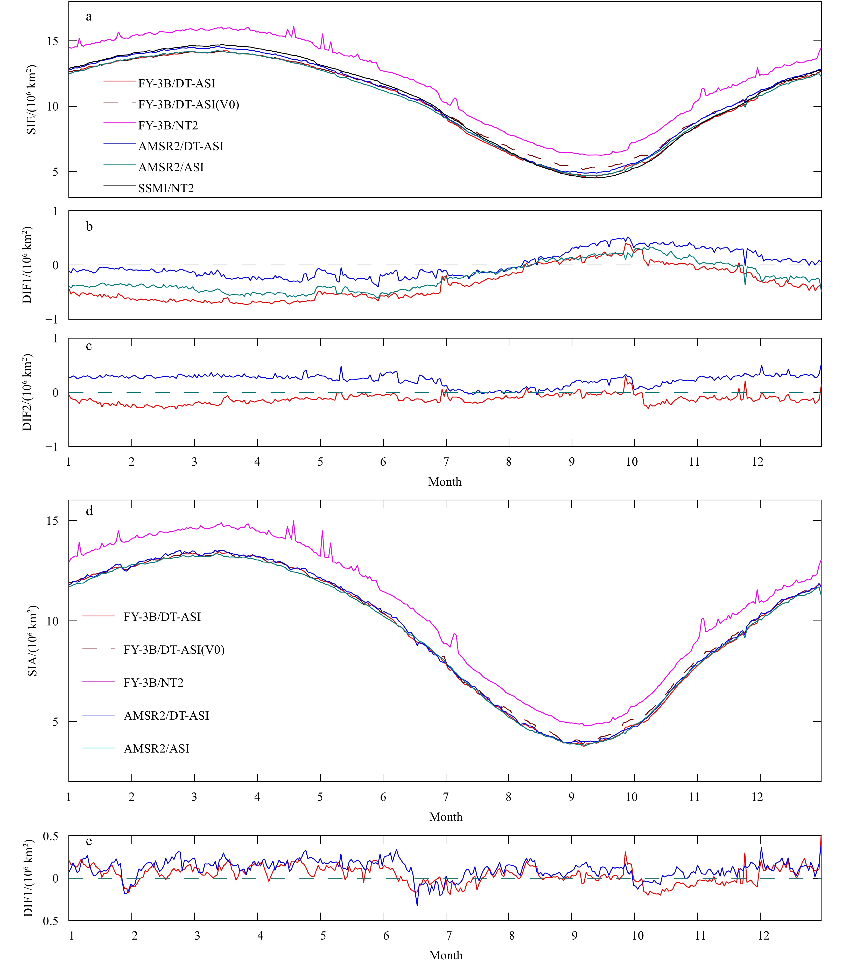
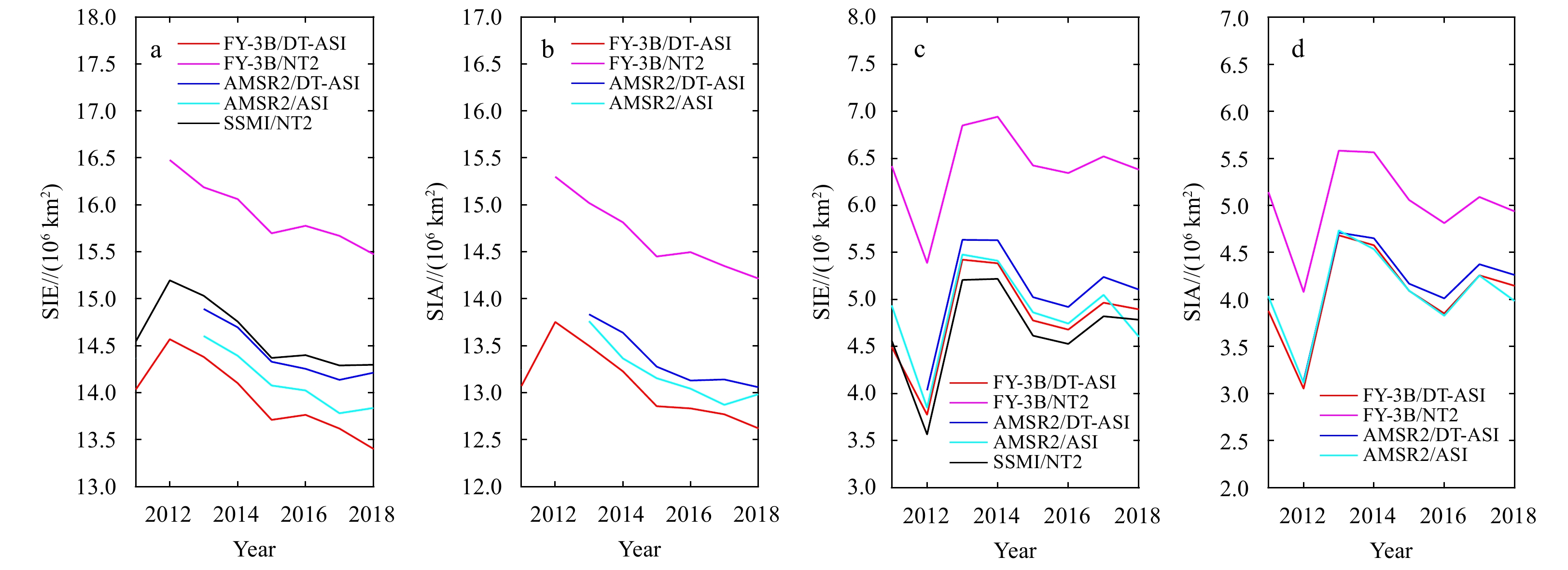
Sea ice concentration (SIC) is one of the most important indicators when monitoring climate changes in the polar region. With the development of the Chinese satellite technology, the FengYun (FY) series has been applied to retrieve the sea ice parameters in the polar region. In this paper, to improve the SIC retrieval accuracy from the passive microwave (PM) data of the Microwave Radiation Imager (MWRI) aboard on the FengYun-3B (FY-3B) Satellite, the dynamic tie-point (DT) Arctic Radiation and Turbulence Interaction Study (ARTIST) Sea Ice (ASI) (DT-ASI) SIC retrieval algorithm is applied and obtained Arctic SIC data for nearly 10 a (from November 18, 2010 to August 19, 2019). Also, by applying a land spillover correction scheme, the erroneous sea ice along coastlines in melt season is removed. The results of FY-3B/DT-ASI are obviously improved compared to that of FY-3B/NT2 (NASA-Team2) in both SIC and sea ice extent (SIE), and are highly consistent with the results of similar products of AMSR2 (Advanced Microwave Scanning Radiometer 2)/ASI and AMSR2/DT-ASI. Compared with the annual average SIC of FY-3B/NT2, our result is reduced by 2.31%. The annual average SIE difference between the two FY-3Bs is 1.65×10⁶ km2, of which the DT-ASI algorithm contributes 87.9% and the land spillover method contributes 12.1%. We further select 58 MODIS (Moderate-resolution Imaging Spectroradiometer) cloud-free samples in the Arctic region and use the tie-point method to retrieve SIC to verify the accuracy of these SIC products. The root mean square difference (RMSD) and mean absolute difference (MAD) of the FY-3B/DT-ASI and MODIS results are 17.2% and 12.7%, which is close to those of two AMSR2 products with 6.25 km resolution and decreased 8% and 7.2% compared with FY-3B/NT2. Further, FY-3B/DT-ASI has the most significant improvement where the SIC is lower than 60%. A high-quality SIC product can be obtained by using the DT-ASI algorithm and our work will be beneficial to promote the application of FengYun Satellite.
Roughness correction method for salinity remote sensing using combined active/passive observations
Wentao Ma, Guihong Liu, Yang Yu, Yanlei Du
2021, 40(11): 189-195. doi: 10.1007/s13131-021-1744-z
Abstract:
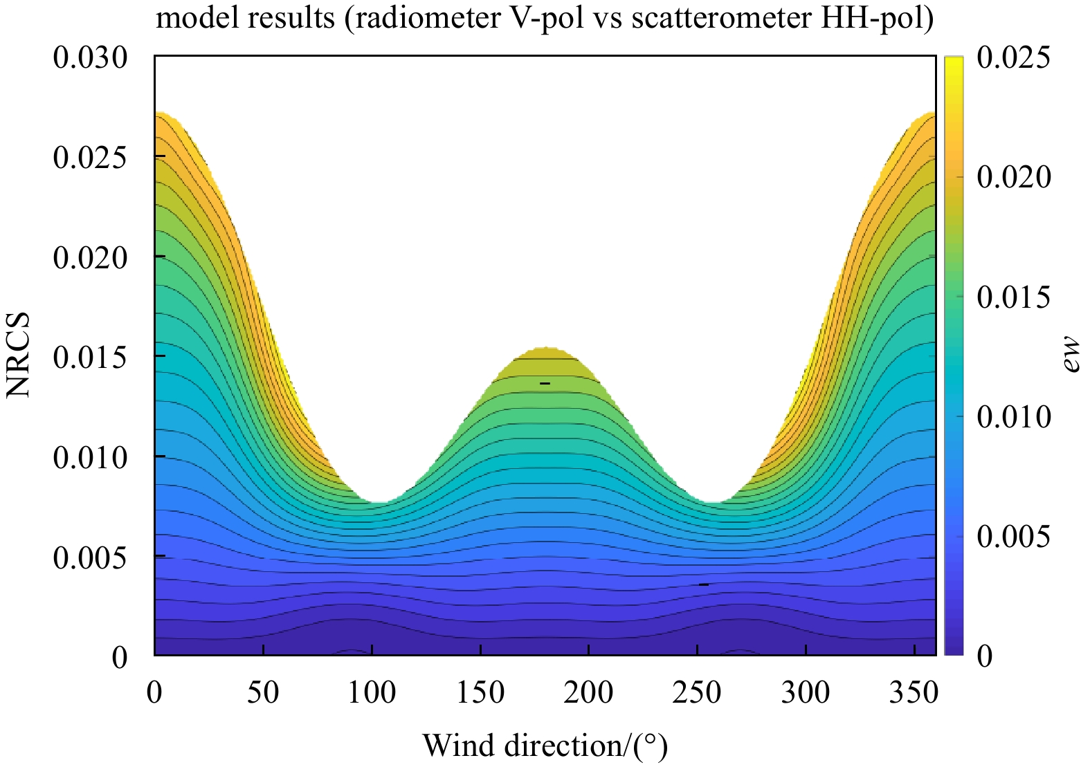
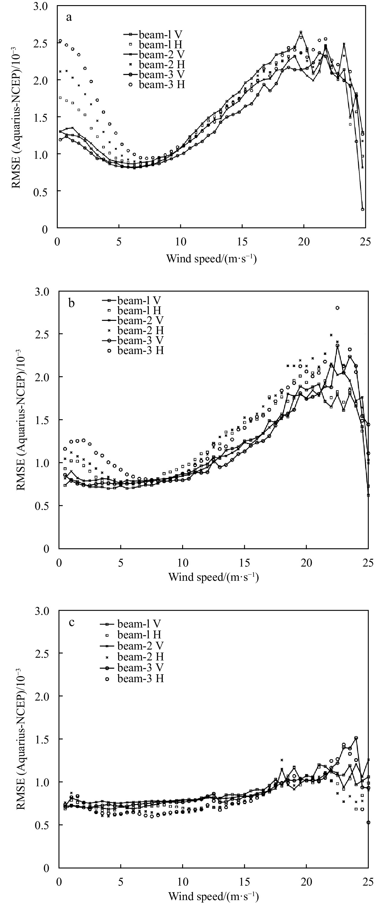
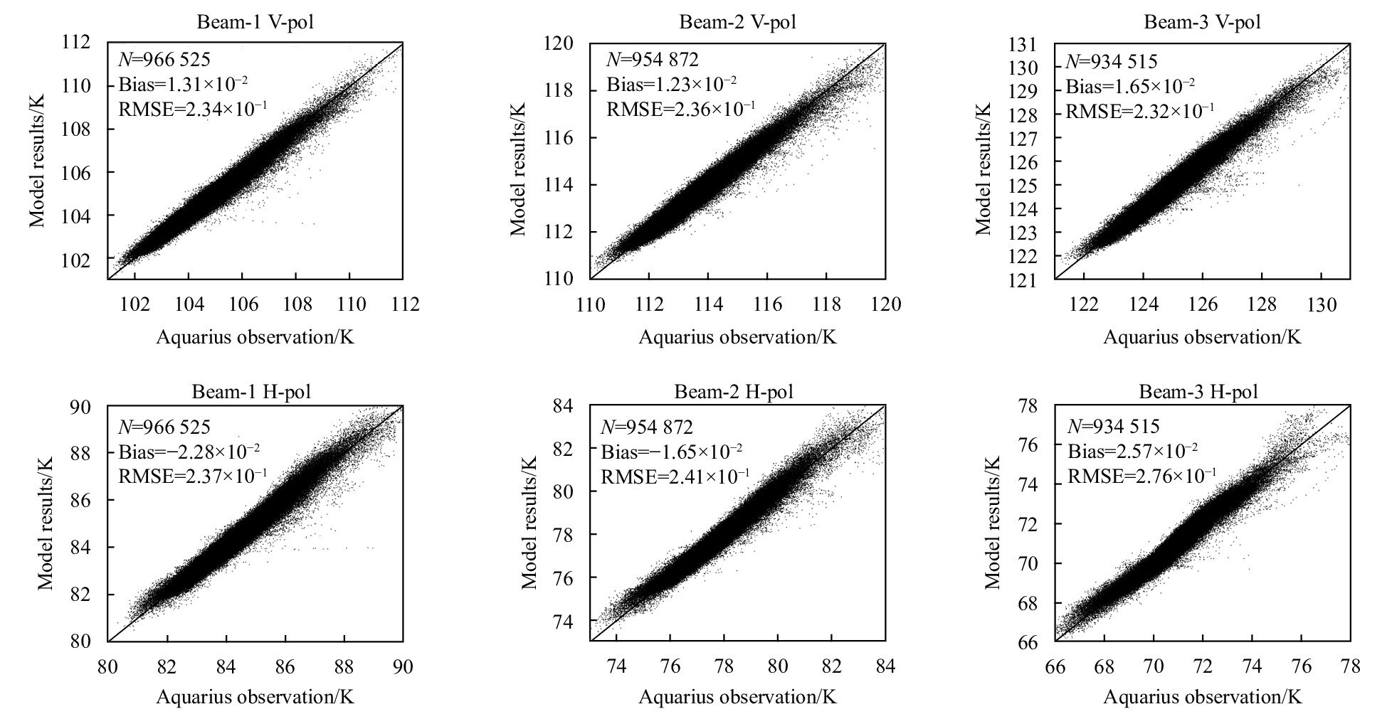
Roughness-induced emission from ocean surfaces is one of the main issues that affects the retrieval accuracy of sea surface salinity remote sensing. In previous studies, the correction of roughness effect mainly depended on wind speeds retrieved from scatterometers or those provided by other means, which necessitates a high requirement for accuracy and synchronicity of wind-speed measurements. The aim of this study is to develop a novel roughness correction model of ocean emissivity for the salinity retrieval application. The combined active/passive observations of normalized radar cross-sections (NRCSs) and emissivities from ocean surfaces given by the L-band Aquarius/SAC-D mission, and the auxiliary wind directions collocated from the National Centers for Environmental Prediction (NCEP) dataset are used for model development. The model is validated against the observations and the Aquarius standard algorithms of roughness-induced emissivity correction. Comparisons between model computations and measurements indicate that the model has better accuracy in computing wind-induced brightness temperature in the upwind/downwind directions or for the surfaces with smaller NRCSs, which can be better than 0.3 K. However, for crosswind directions and larger NRCSs, the model accuracy is relatively low. A model using HH-polarized NRCSs yields better accuracy than that using VV-polarized ones. For a fair comparison to the Aquarius standard algorithms using wind speeds retrieved from multi-source data, the maximum likelihood estimation is employed to produce results combining our model calculations and those using other sources. Numerical simulations show that combined results basically have higher accuracy than the standard algorithms.
News and Views
Advances in interscale and interdisciplinary approaches to the South China Sea
Lingling Xie, Yi Guan, Jianyu Hu, Quanan Zheng
2021, 40(11): 196-199. doi: 10.1007/s13131-021-1963-3
Abstract: