2021 Vol. 40, No. 10
Display Method:
2021, (10): 1-2.
Abstract:
2021, 40(10): 1-16.
doi: 10.1007/s13131-021-1881-4
Abstract:
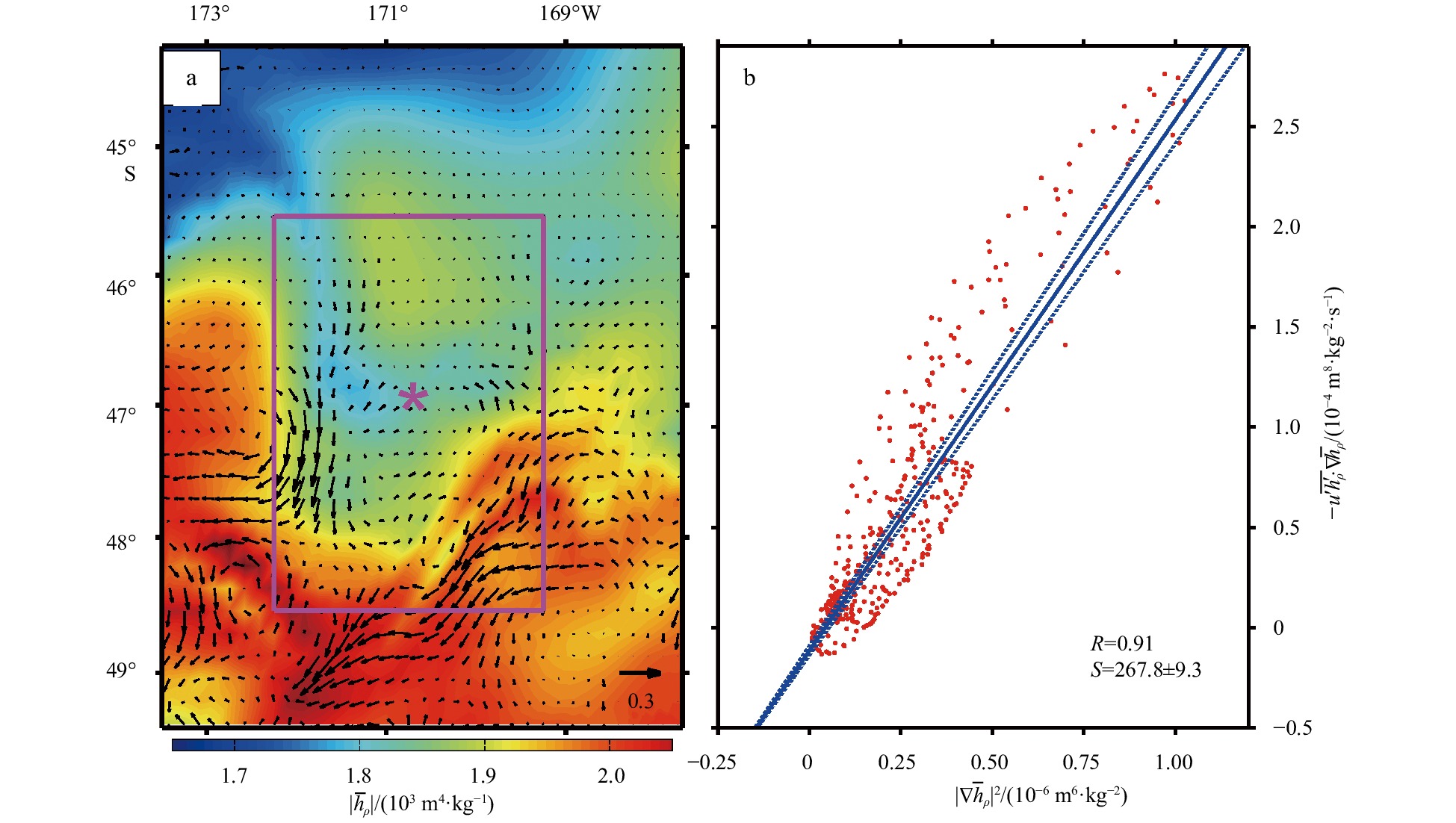
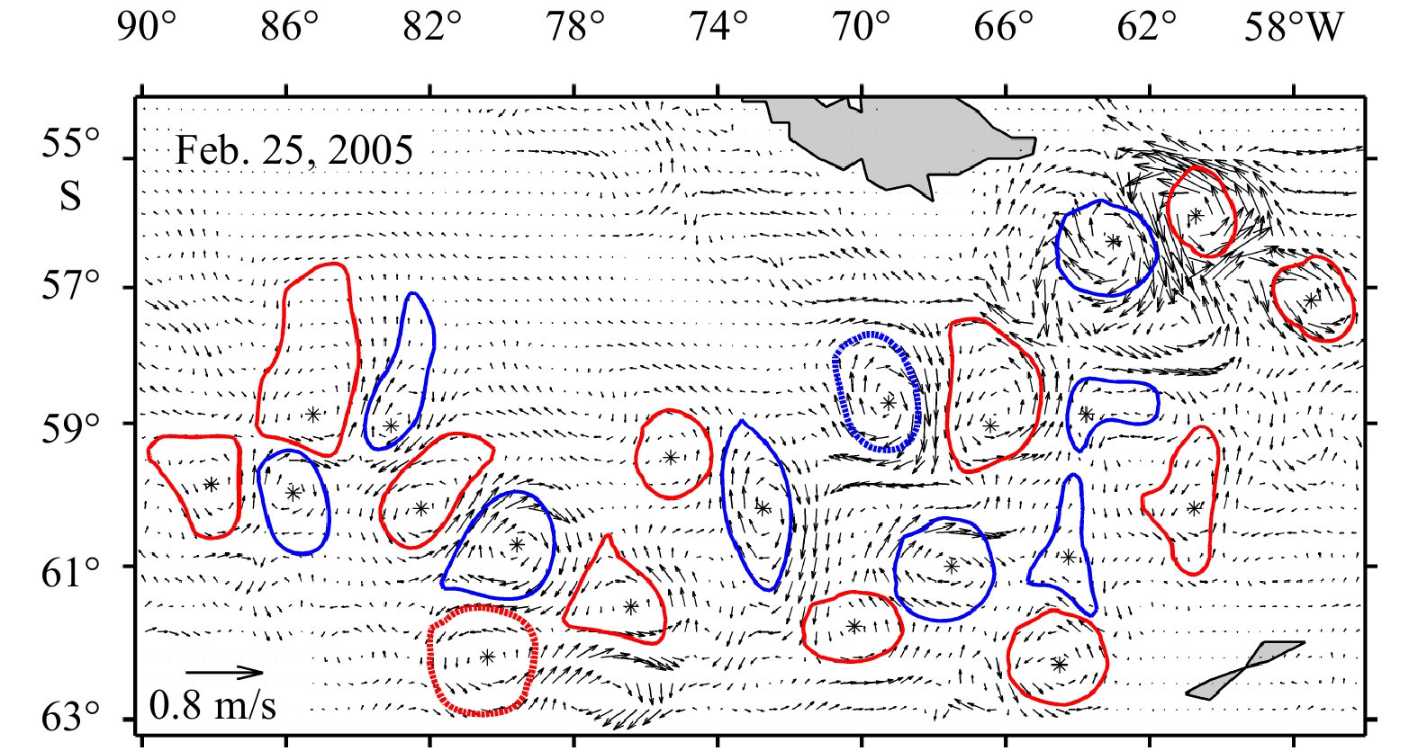
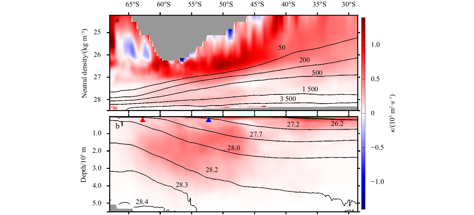
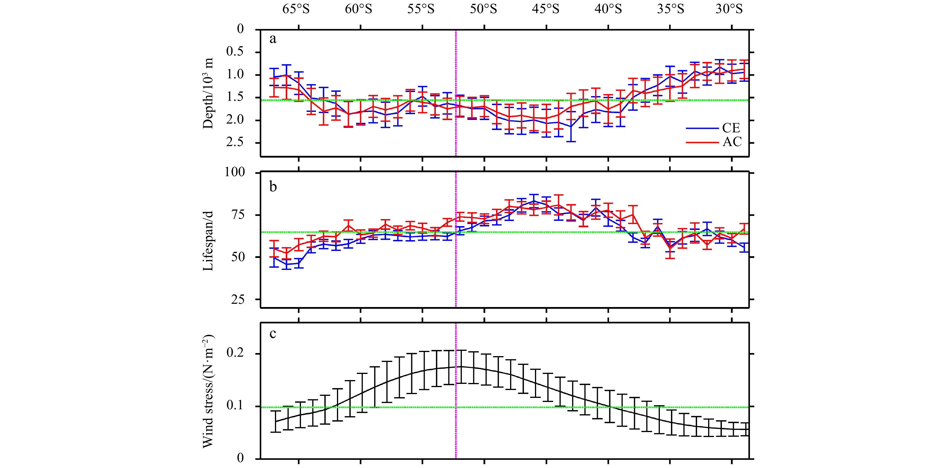
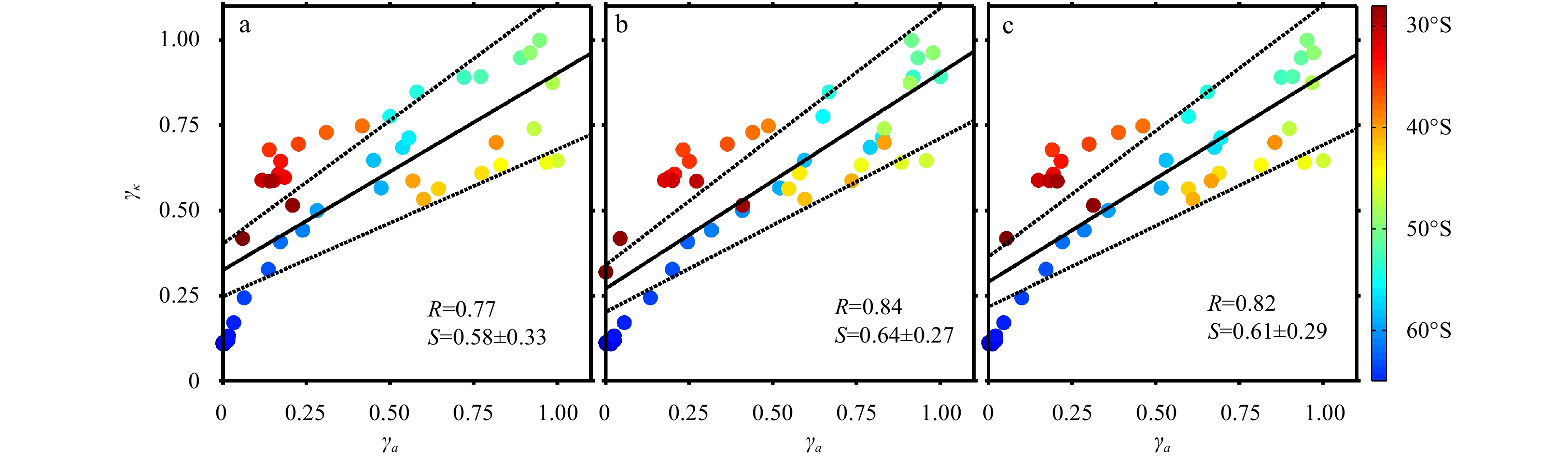
The spatial distribution of eddy diffusivity, basic characteristics of coherent mesoscale eddies and their relationship are analyzed from numerical model outputs in the Southern Ocean. Mesoscale fluctuation information is obtained by a temporal-spatial filtering method, and the eddy diffusivity is calculated using a linear regression analysis between isoneutral thickness flux and large-scale isoneutral thickness gradient. The eddy diffusivity is on the order of O (103 m2/s) with a significant spatial variation, and it is larger in the area with strong coherent mesoscale eddy activity. The mesoscale eddies are mainly located in the upper ocean layer, with the average intensity no larger than 0.2. The mean radius of the coherent mesoscale cyclonic (anticyclonic) eddy gradually decays from (121.2±10.4) km ((117.8±9.6) km) at 30°S to (43.9±5.3) km ((44.7±4.9) km) at 65°S. Their vertical penetration depths (lifespans) are deeper (longer) between the northern side of the Subpolar Antarctic Front and 48°S. The normalized eddy diffusivity and coherent mesoscale eddy activity show a significant positive correlation, indicating that coherent mesoscale eddy plays an important role in eddy diffusivity.
The spatial distribution of eddy diffusivity, basic characteristics of coherent mesoscale eddies and their relationship are analyzed from numerical model outputs in the Southern Ocean. Mesoscale fluctuation information is obtained by a temporal-spatial filtering method, and the eddy diffusivity is calculated using a linear regression analysis between isoneutral thickness flux and large-scale isoneutral thickness gradient. The eddy diffusivity is on the order of O (103 m2/s) with a significant spatial variation, and it is larger in the area with strong coherent mesoscale eddy activity. The mesoscale eddies are mainly located in the upper ocean layer, with the average intensity no larger than 0.2. The mean radius of the coherent mesoscale cyclonic (anticyclonic) eddy gradually decays from (121.2±10.4) km ((117.8±9.6) km) at 30°S to (43.9±5.3) km ((44.7±4.9) km) at 65°S. Their vertical penetration depths (lifespans) are deeper (longer) between the northern side of the Subpolar Antarctic Front and 48°S. The normalized eddy diffusivity and coherent mesoscale eddy activity show a significant positive correlation, indicating that coherent mesoscale eddy plays an important role in eddy diffusivity.


2021, 40(10): 17-29.
doi: 10.1007/s13131-021-1770-x
Abstract:
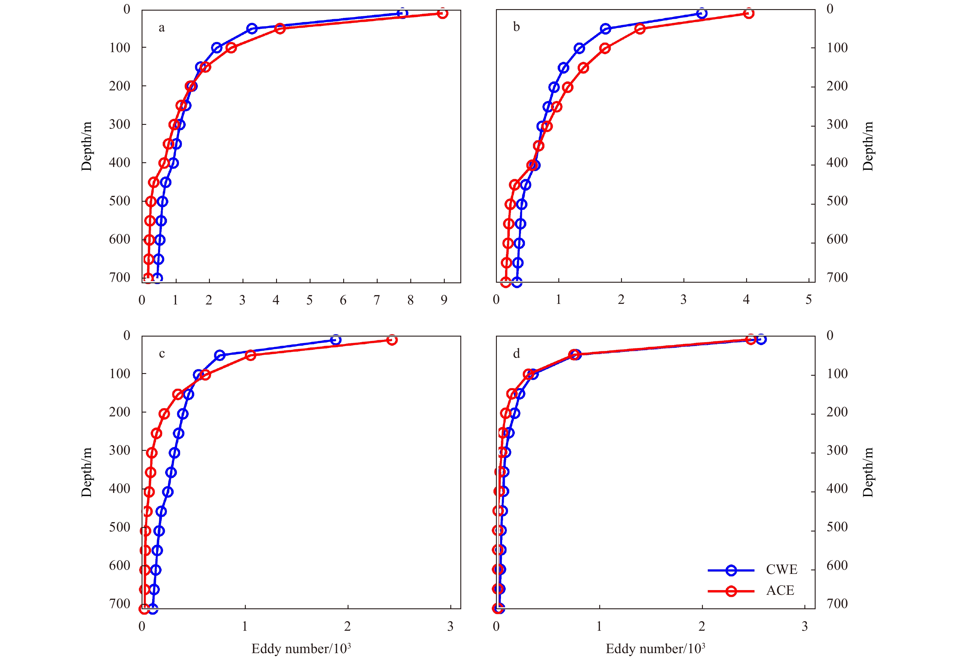
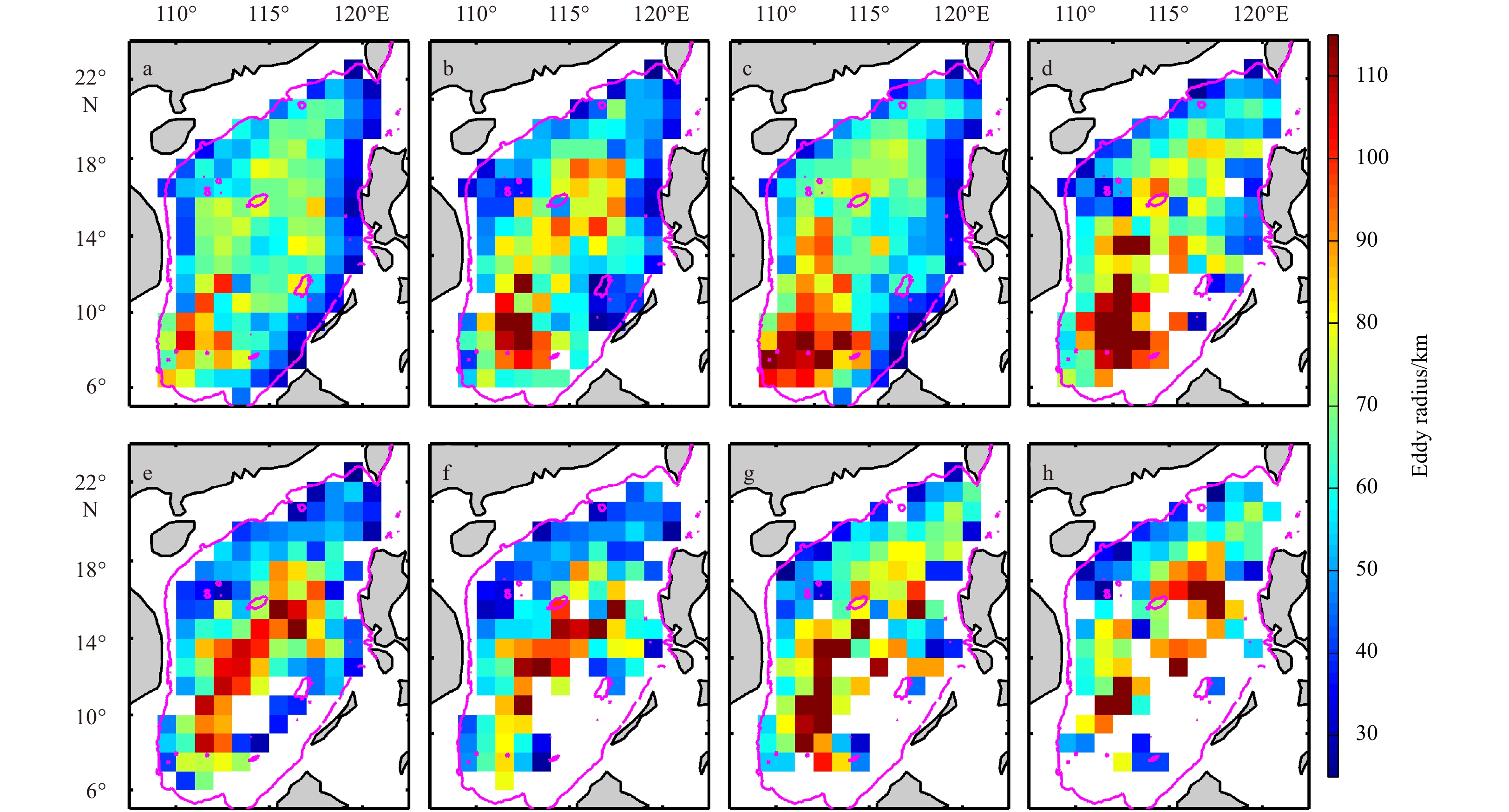
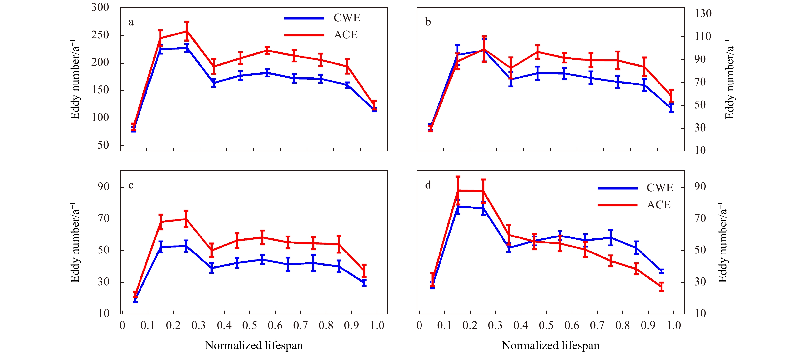
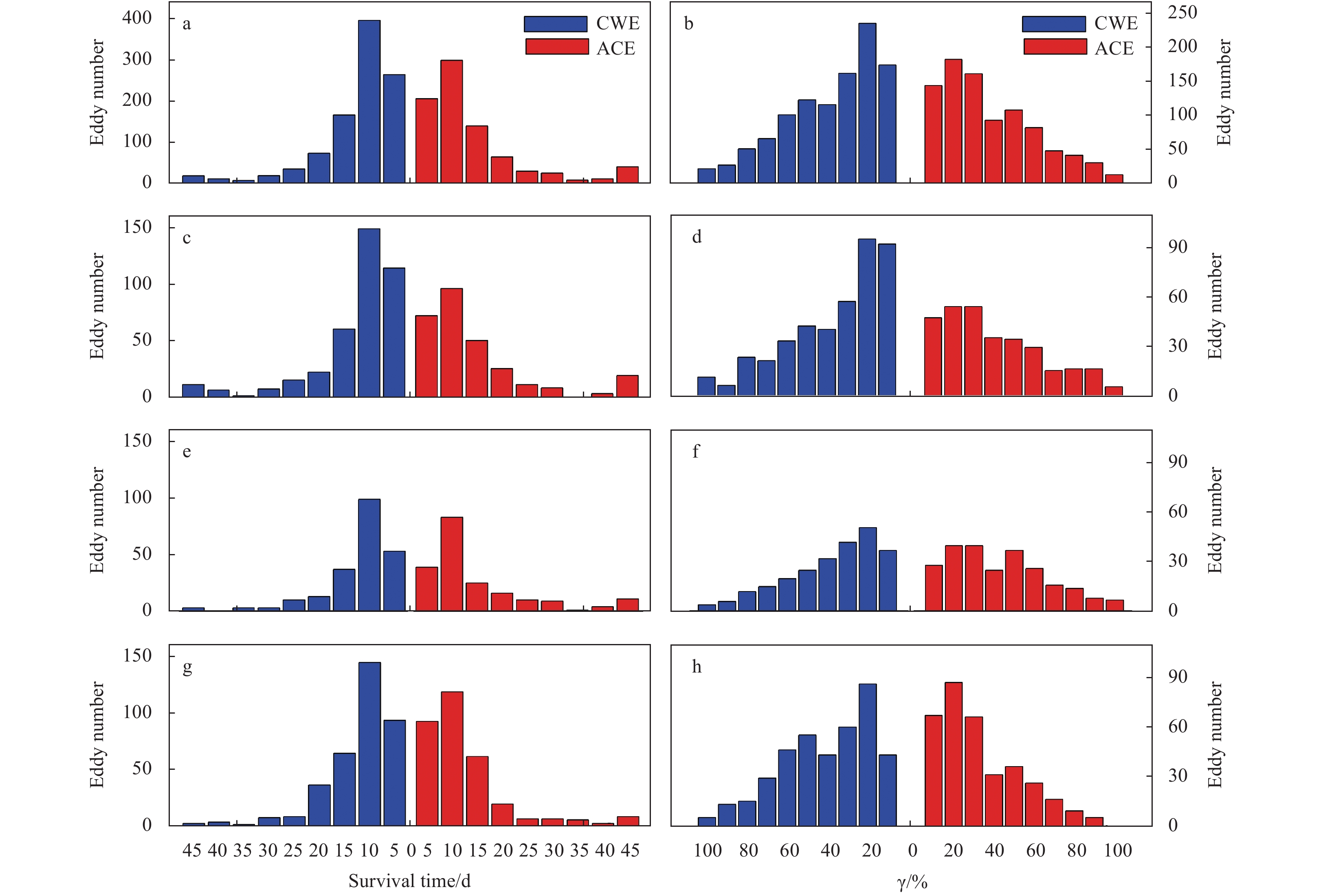
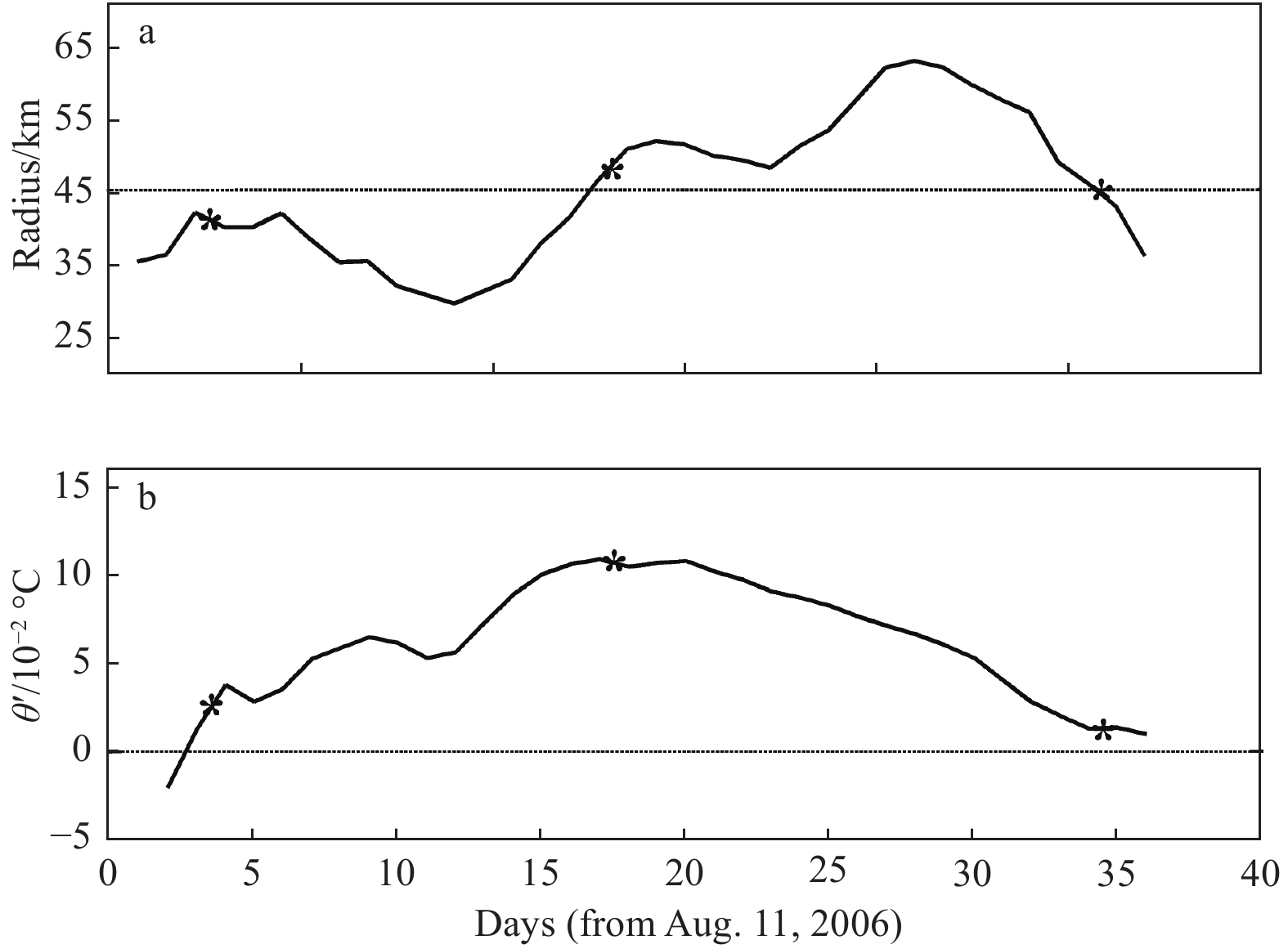
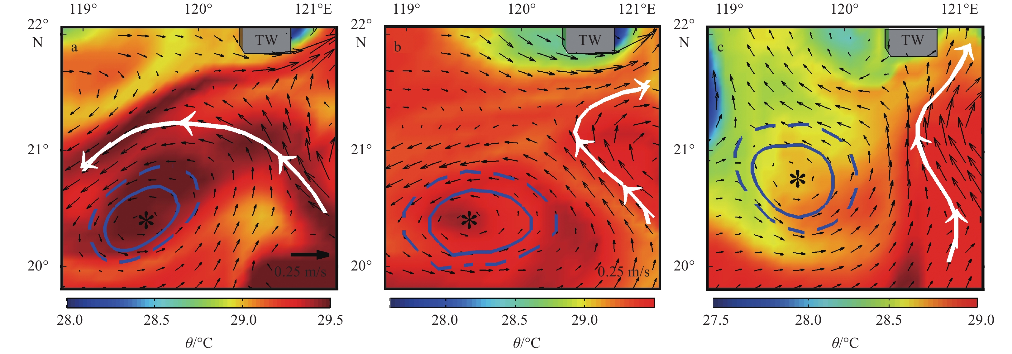
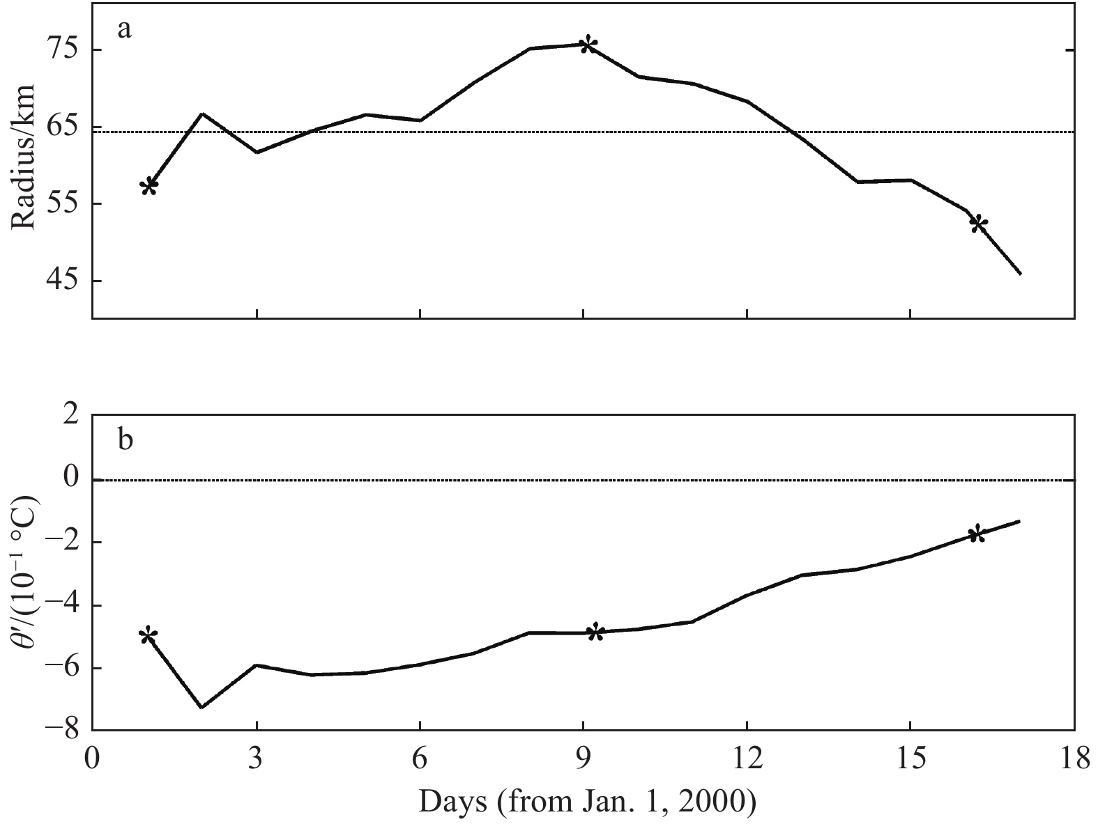
In general, a mesoscale cyclonic (anticyclonic) eddy has a colder (warmer) core, and it is considered as a cold (warm) eddy. However, recently research found that there are a number of “abnormal” mesoscale cyclonic (anticyclonic) eddies associated with warm (cold) cores in the South China Sea (SCS). These “abnormal” eddies pose a challenge to previous works on eddy detection, characteristic analysis, eddy-induced heat and salt transports, and even on mesoscale eddy dynamics. Based on a 9-year (2000–2008) numerical modelling data, the cyclonic warm-core eddies (CWEs) and anticyclonic cold-core eddies (ACEs) in the SCS are analyzed. This study found that the highest incidence area of the “abnormal” eddies is the northwest of Luzon Strait. In terms of the eddy snapshot counting method, 8 620 CWEs and 9 879 ACEs are detected, accounting for 14.6% and 15.8% of the total eddy number, respectively. The size of the “abnormal” eddies is usually smaller than that of the “normal” eddies, with the radius only around 50 km. In the generation time aspect, they usually appear within the 0.1–0.3 interval in the normalized eddy lifespan. The survival time of CWEs (ACEs) occupies 16.3% (17.1%) of the total eddy lifespan. Based on two case studies, the intrusion of Kuroshio warm water is considered as a key mechanism for the generation of these “abnormal” eddies near the northeastern SCS.
In general, a mesoscale cyclonic (anticyclonic) eddy has a colder (warmer) core, and it is considered as a cold (warm) eddy. However, recently research found that there are a number of “abnormal” mesoscale cyclonic (anticyclonic) eddies associated with warm (cold) cores in the South China Sea (SCS). These “abnormal” eddies pose a challenge to previous works on eddy detection, characteristic analysis, eddy-induced heat and salt transports, and even on mesoscale eddy dynamics. Based on a 9-year (2000–2008) numerical modelling data, the cyclonic warm-core eddies (CWEs) and anticyclonic cold-core eddies (ACEs) in the SCS are analyzed. This study found that the highest incidence area of the “abnormal” eddies is the northwest of Luzon Strait. In terms of the eddy snapshot counting method, 8 620 CWEs and 9 879 ACEs are detected, accounting for 14.6% and 15.8% of the total eddy number, respectively. The size of the “abnormal” eddies is usually smaller than that of the “normal” eddies, with the radius only around 50 km. In the generation time aspect, they usually appear within the 0.1–0.3 interval in the normalized eddy lifespan. The survival time of CWEs (ACEs) occupies 16.3% (17.1%) of the total eddy lifespan. Based on two case studies, the intrusion of Kuroshio warm water is considered as a key mechanism for the generation of these “abnormal” eddies near the northeastern SCS.


2021, 40(10): 30-37.
doi: 10.1007/s13131-021-1889-9
Abstract:
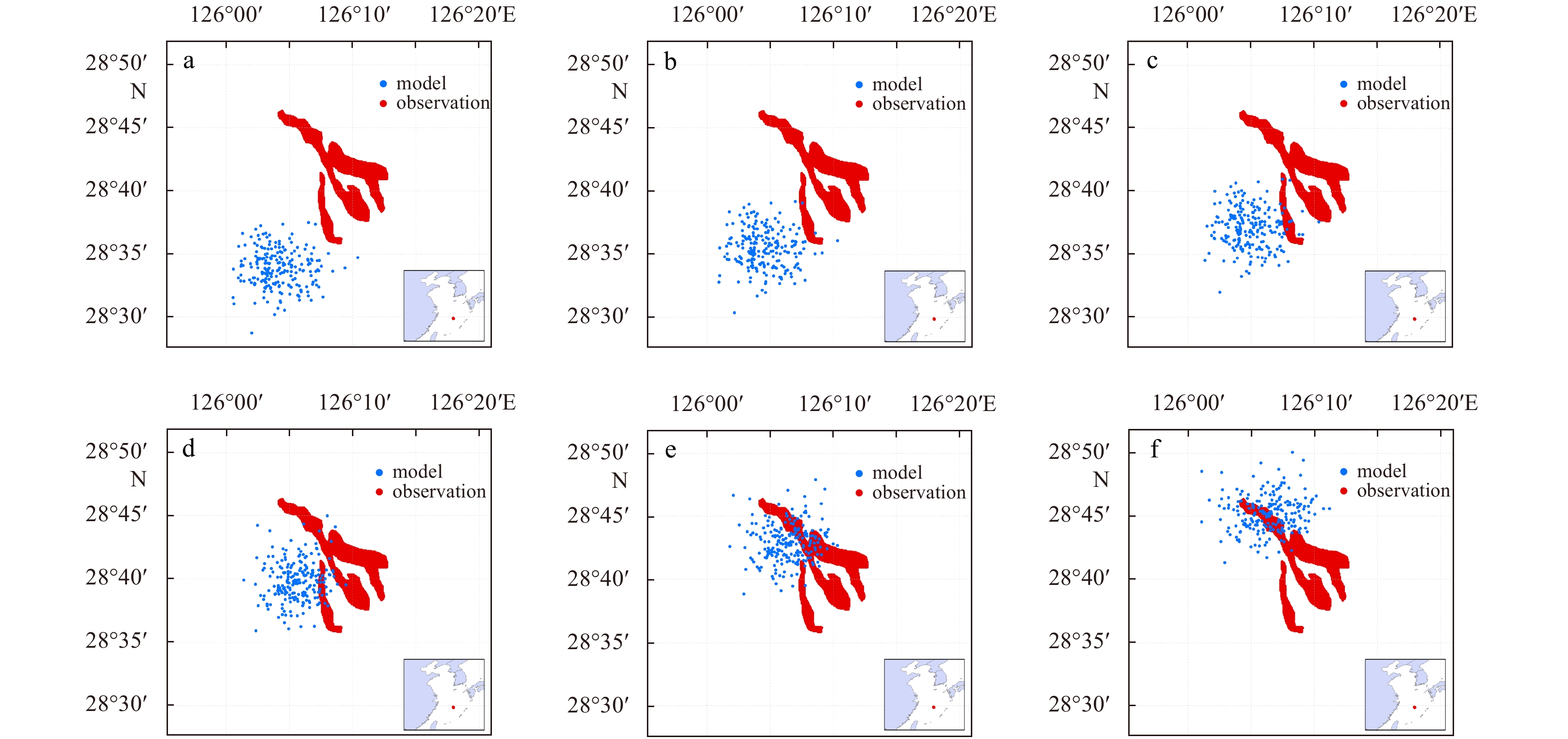
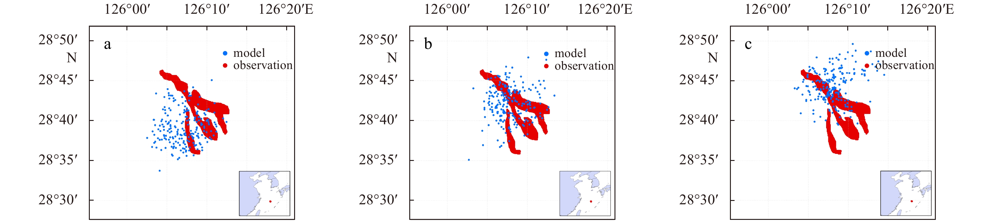
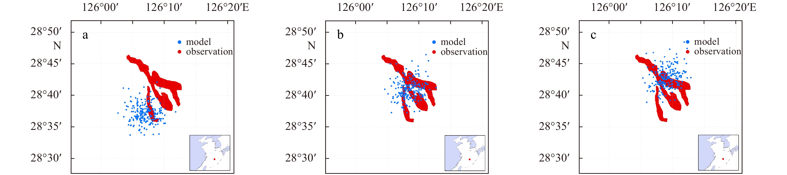
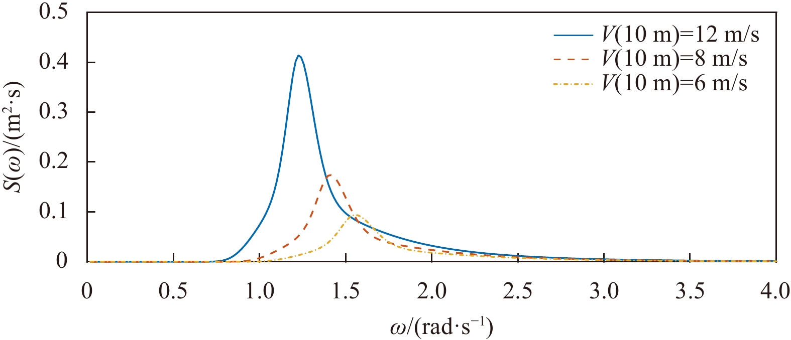
Spilled oil floats and travels across the water’s surface under the influence of wind, currents, and wave action. Wave-induced Stokes drift is an important physical process that can affect surface water particles but that is currently absent from oil spill analyses. In this study, two methods are applied to determine the velocity of Stokes drift, the first calculates velocity from the wind-related formula based upon a one-dimensional frequency spectrum, while the second determines velocity directly from the wave model that was based on a two-dimensional spectrum. The experimental results of numerous models indicated that: (1) oil simulations that include the influence of Stokes drift are more accurate than that those do not; (2) for medium and long-term simulations longer than two days or more, Stokes drift is a significant factor that should not be ignored, and its magnitude can reach about 2% of the wind speed; (3) the velocity of Stokes drift is related to the wind but is not linear. Therefore, Stokes drift cannot simply be replaced or substituted by simply increasing the wind drift factor, which can cause errors in oil spill projections; (4) the Stokes drift velocity obtained from the two-dimensional wave spectrum makes the oil spill simulation more accurate.
Spilled oil floats and travels across the water’s surface under the influence of wind, currents, and wave action. Wave-induced Stokes drift is an important physical process that can affect surface water particles but that is currently absent from oil spill analyses. In this study, two methods are applied to determine the velocity of Stokes drift, the first calculates velocity from the wind-related formula based upon a one-dimensional frequency spectrum, while the second determines velocity directly from the wave model that was based on a two-dimensional spectrum. The experimental results of numerous models indicated that: (1) oil simulations that include the influence of Stokes drift are more accurate than that those do not; (2) for medium and long-term simulations longer than two days or more, Stokes drift is a significant factor that should not be ignored, and its magnitude can reach about 2% of the wind speed; (3) the velocity of Stokes drift is related to the wind but is not linear. Therefore, Stokes drift cannot simply be replaced or substituted by simply increasing the wind drift factor, which can cause errors in oil spill projections; (4) the Stokes drift velocity obtained from the two-dimensional wave spectrum makes the oil spill simulation more accurate.


2021, 40(10): 38-48.
doi: 10.1007/s13131-021-1871-6
Abstract:
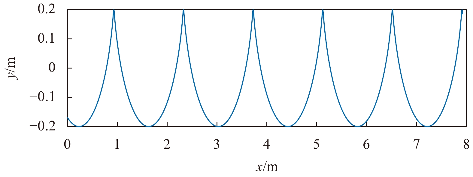
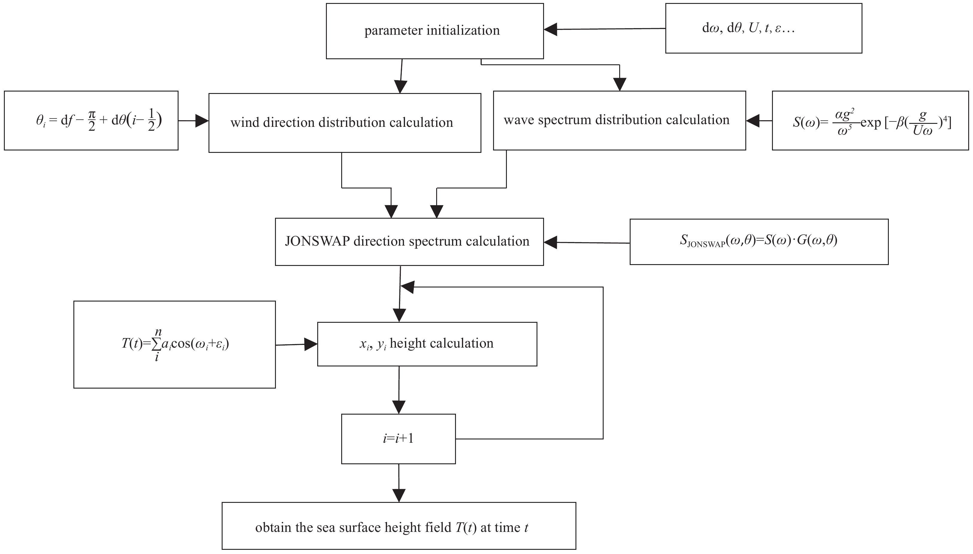
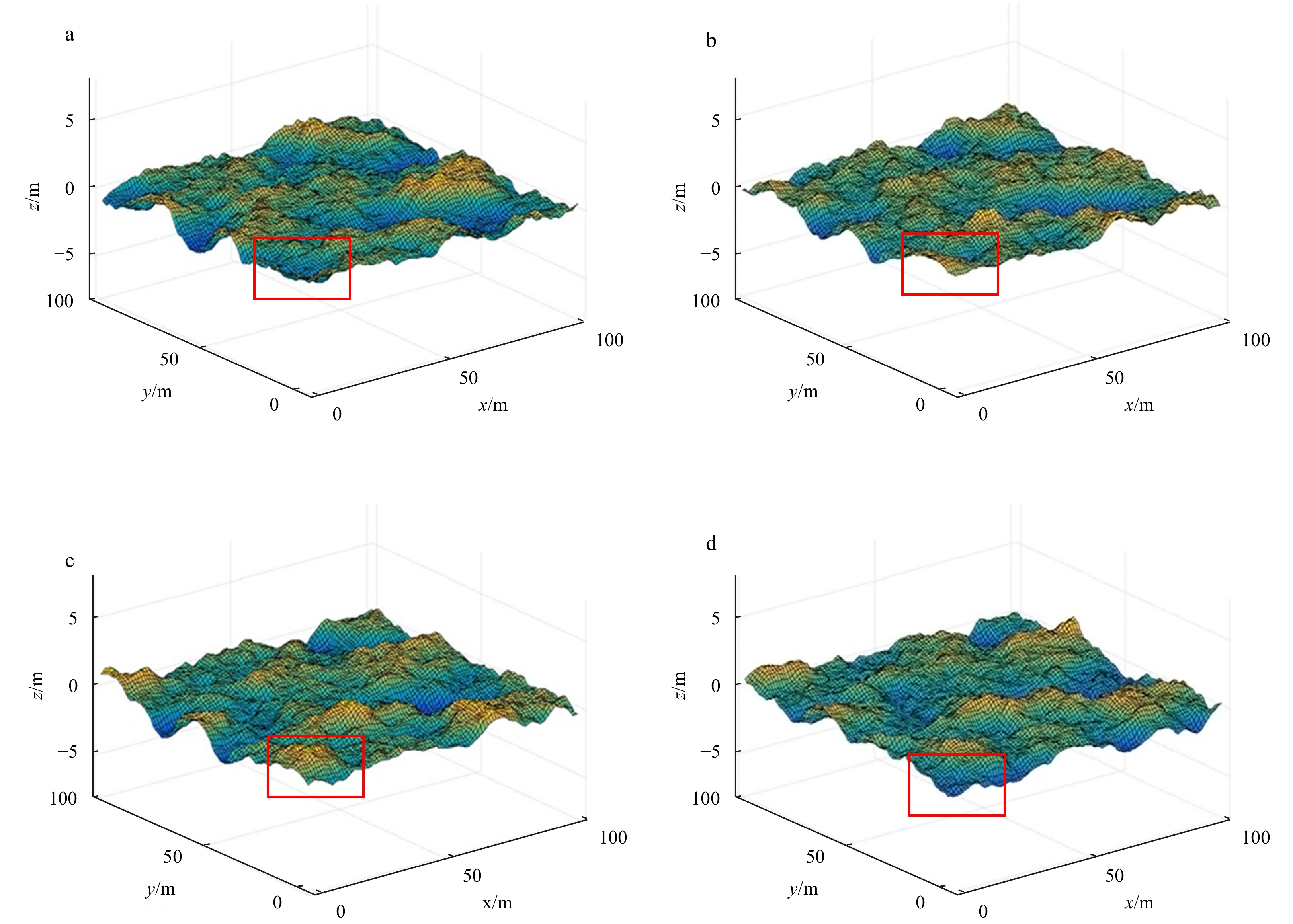
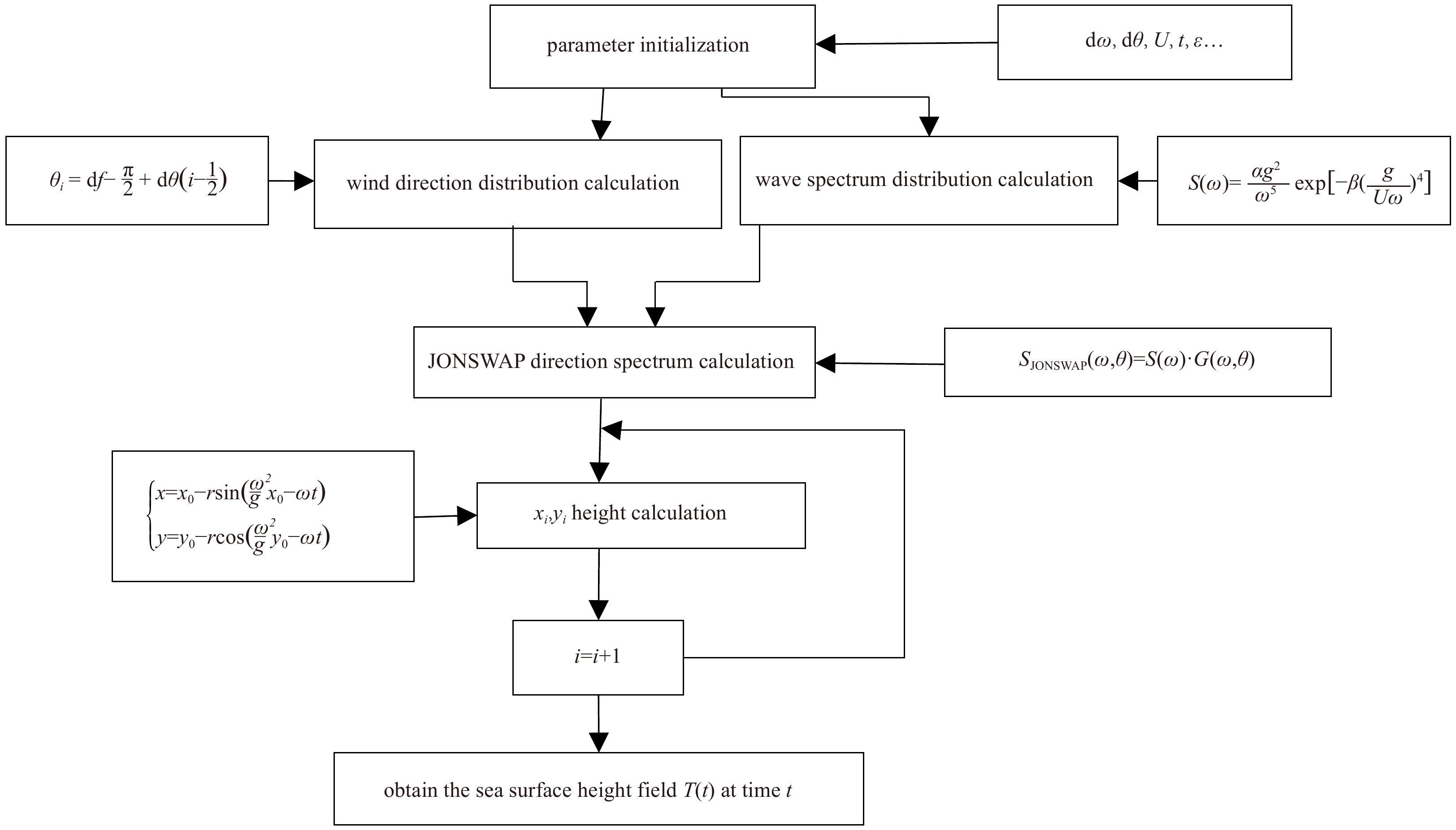
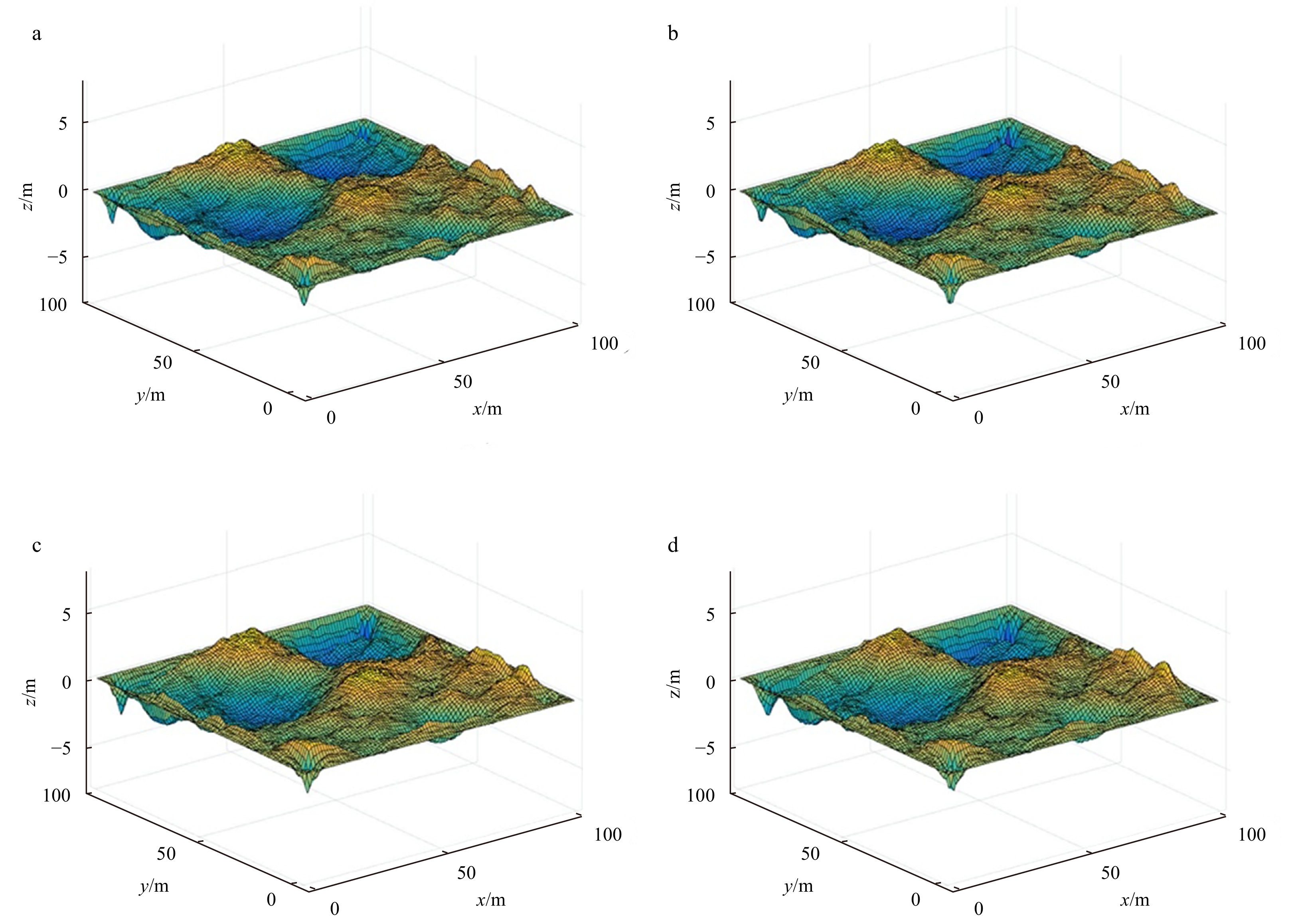
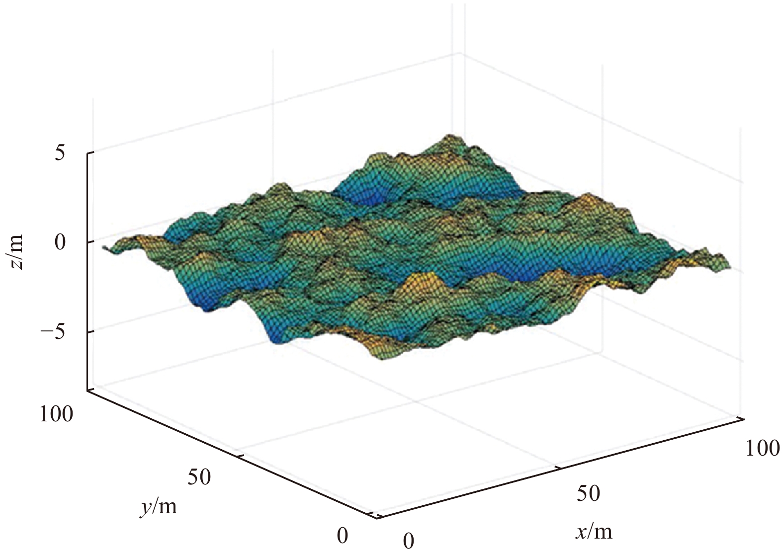
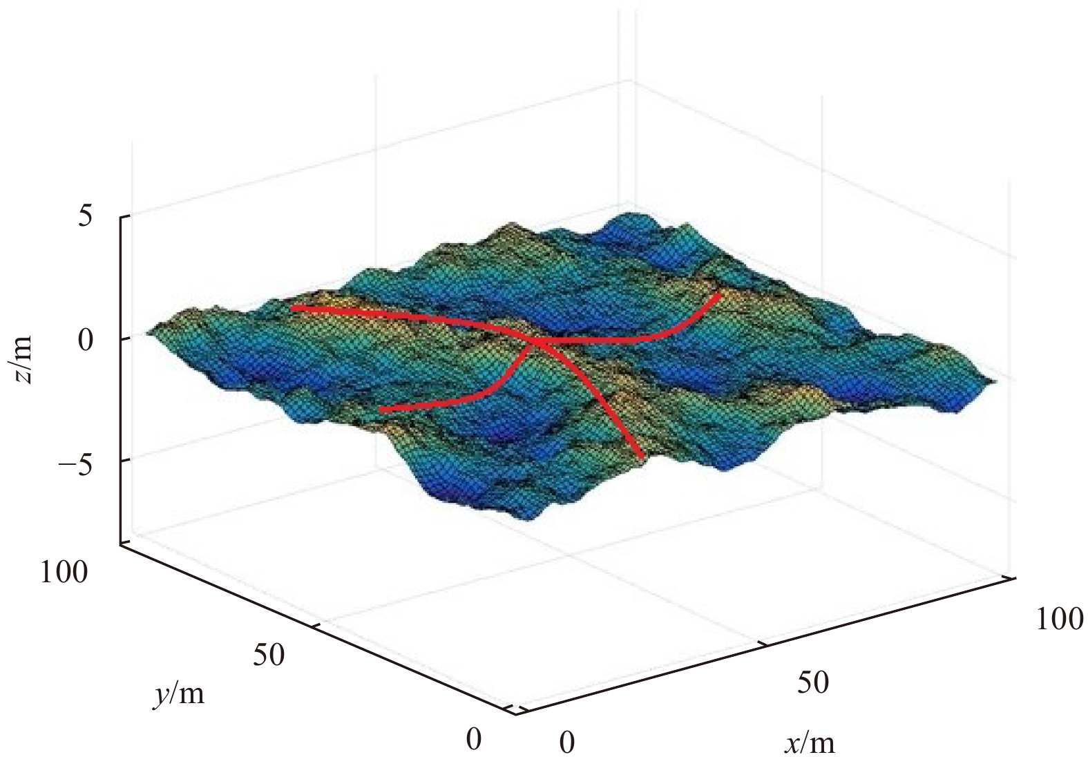
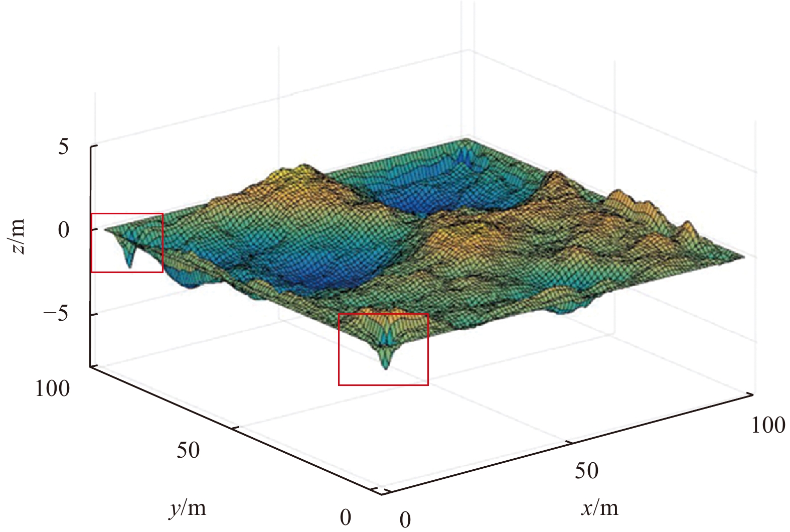
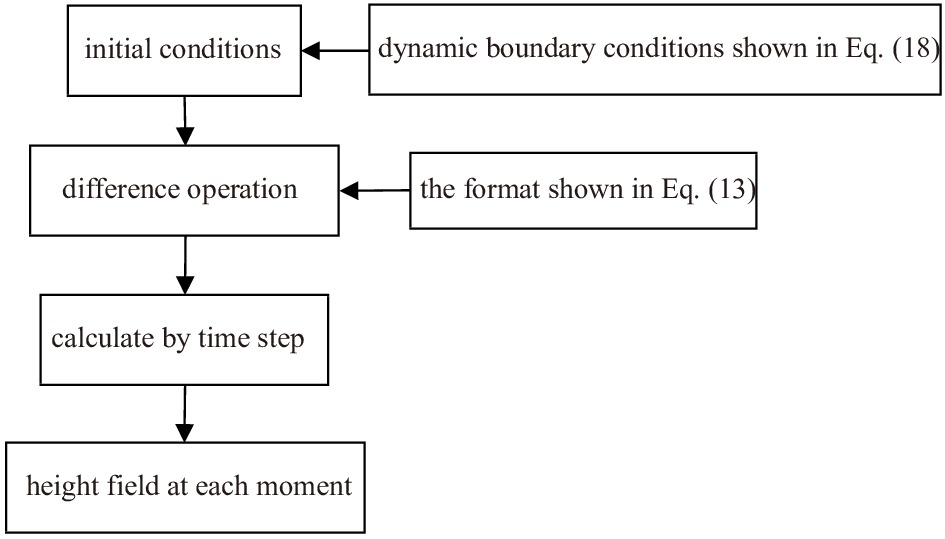
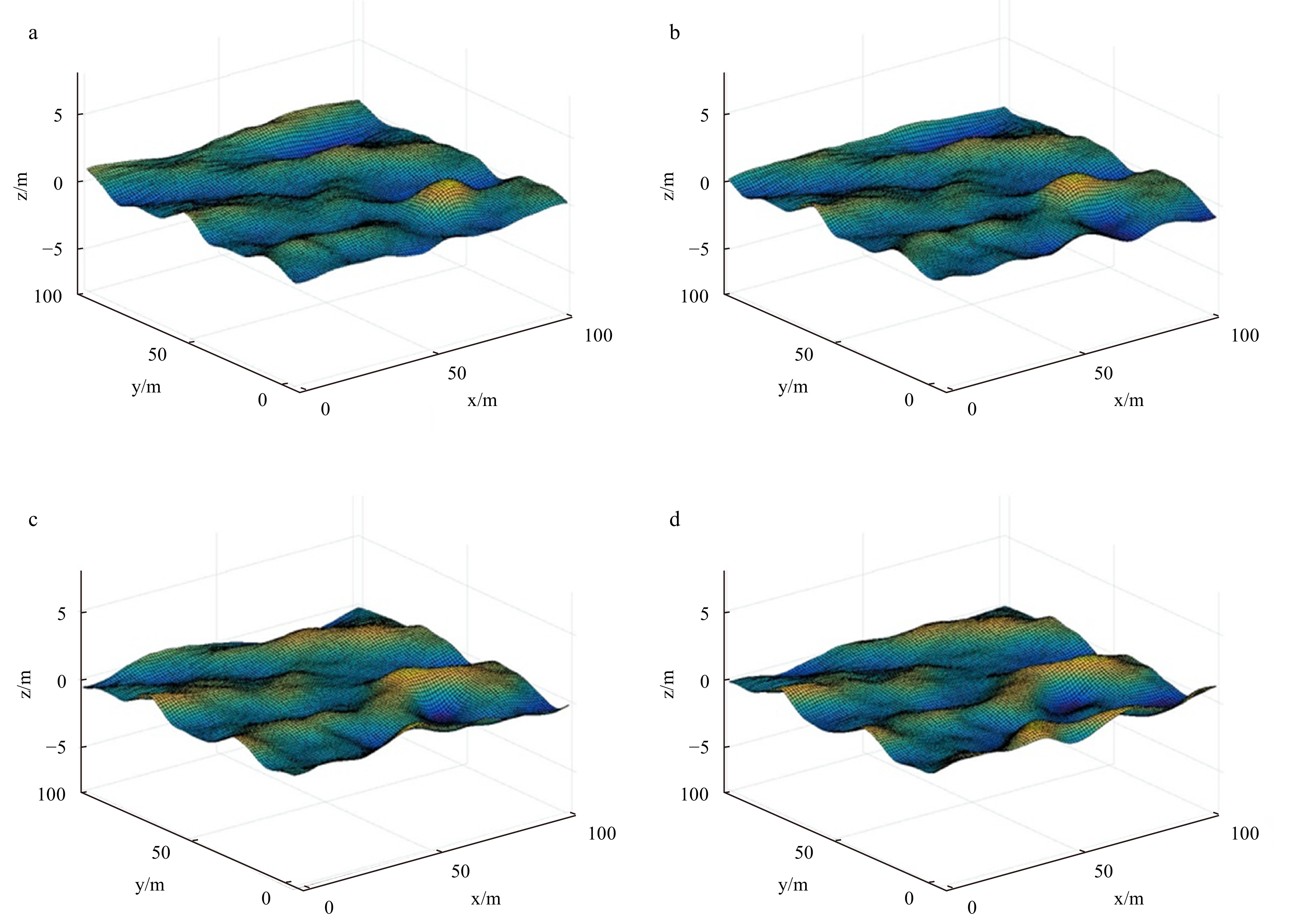
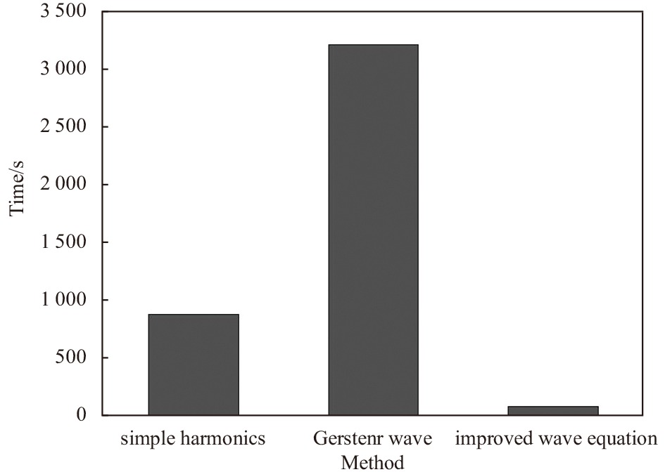
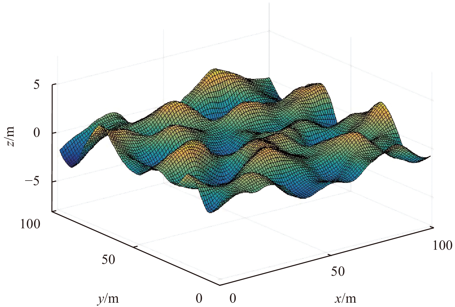
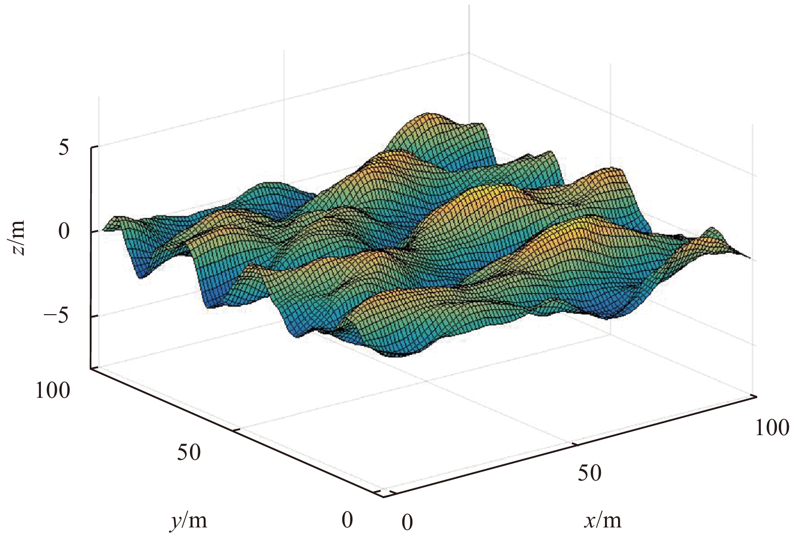
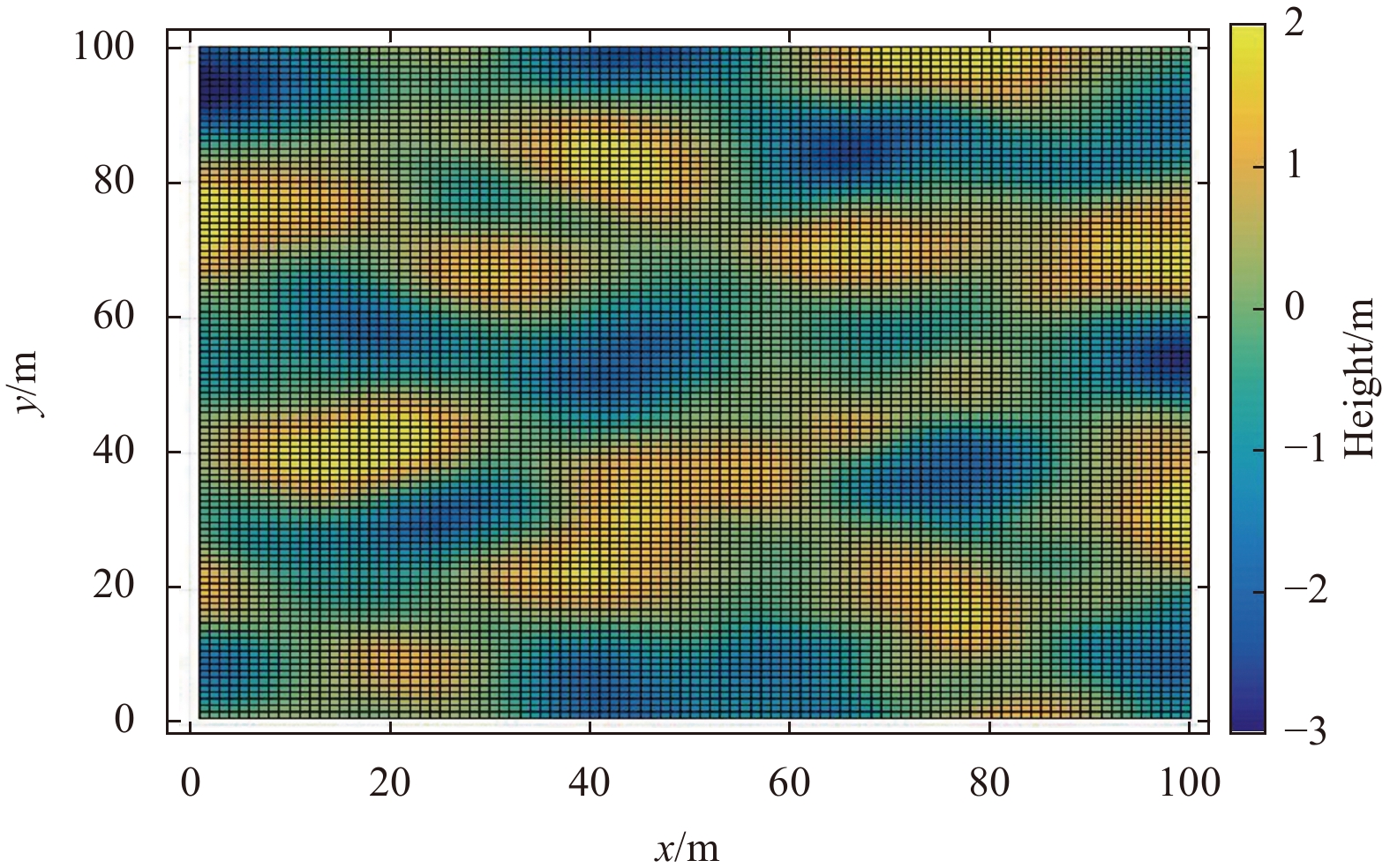
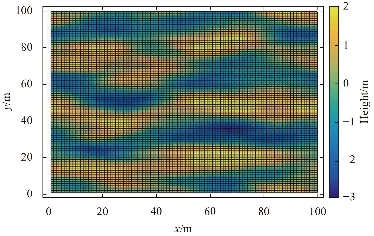
In conventional marine seismic exploration data processing, the sea surface is usually treated as a horizontal free boundary. However, the sea surface is affected by wind and waves and there often exists dynamic small-range fluctuations. These dynamic fluctuations will change the energy propagation path and affect the final imaging results. In theoretical research, different sea surface conditions need to be described, so it is necessary to study the modeling method of dynamic undulating sea surface. Starting from the commonly used sea surface mathematical simulation methods, this paper mainly studies the realization process of simple harmonic wave and Gerstner wave sea surface simulation methods based on ocean wave spectrum, and compares their advantages and disadvantages. Aiming at the shortcomings of the simple harmonic method and Gerstner method in calculational speed and sea surface simulation effect, a method based on wave equation and using dynamic boundary conditions for sea surface simulation is proposed. The calculational speed of this method is much faster than the commonly used simple harmonic method and Gerstner wave method. In addition, this paper also compares the new method with the more commonly used higher-order spectral methods to show the characteristics of the improved wave equation method.
In conventional marine seismic exploration data processing, the sea surface is usually treated as a horizontal free boundary. However, the sea surface is affected by wind and waves and there often exists dynamic small-range fluctuations. These dynamic fluctuations will change the energy propagation path and affect the final imaging results. In theoretical research, different sea surface conditions need to be described, so it is necessary to study the modeling method of dynamic undulating sea surface. Starting from the commonly used sea surface mathematical simulation methods, this paper mainly studies the realization process of simple harmonic wave and Gerstner wave sea surface simulation methods based on ocean wave spectrum, and compares their advantages and disadvantages. Aiming at the shortcomings of the simple harmonic method and Gerstner method in calculational speed and sea surface simulation effect, a method based on wave equation and using dynamic boundary conditions for sea surface simulation is proposed. The calculational speed of this method is much faster than the commonly used simple harmonic method and Gerstner wave method. In addition, this paper also compares the new method with the more commonly used higher-order spectral methods to show the characteristics of the improved wave equation method.


2021, 40(10): 49-64.
doi: 10.1007/s13131-021-1831-1
Abstract:
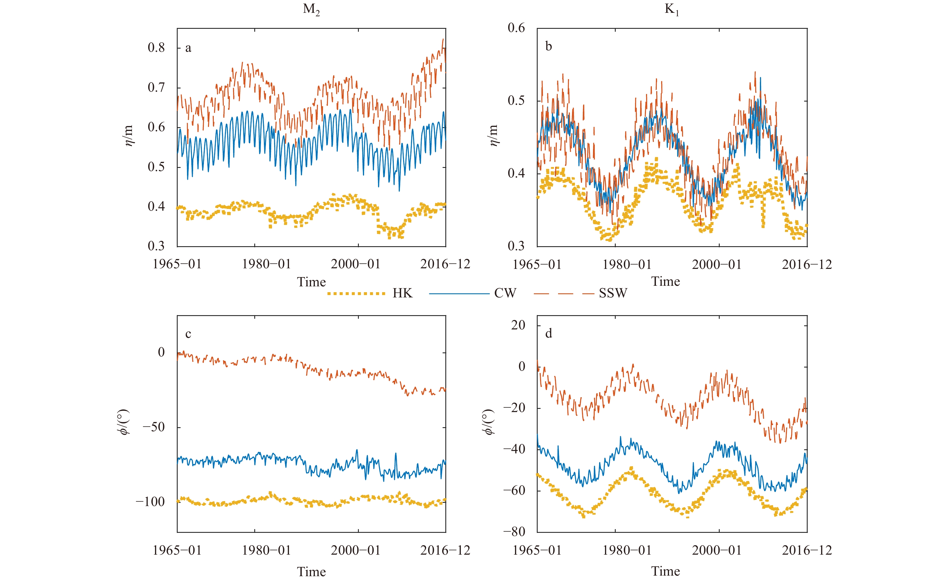
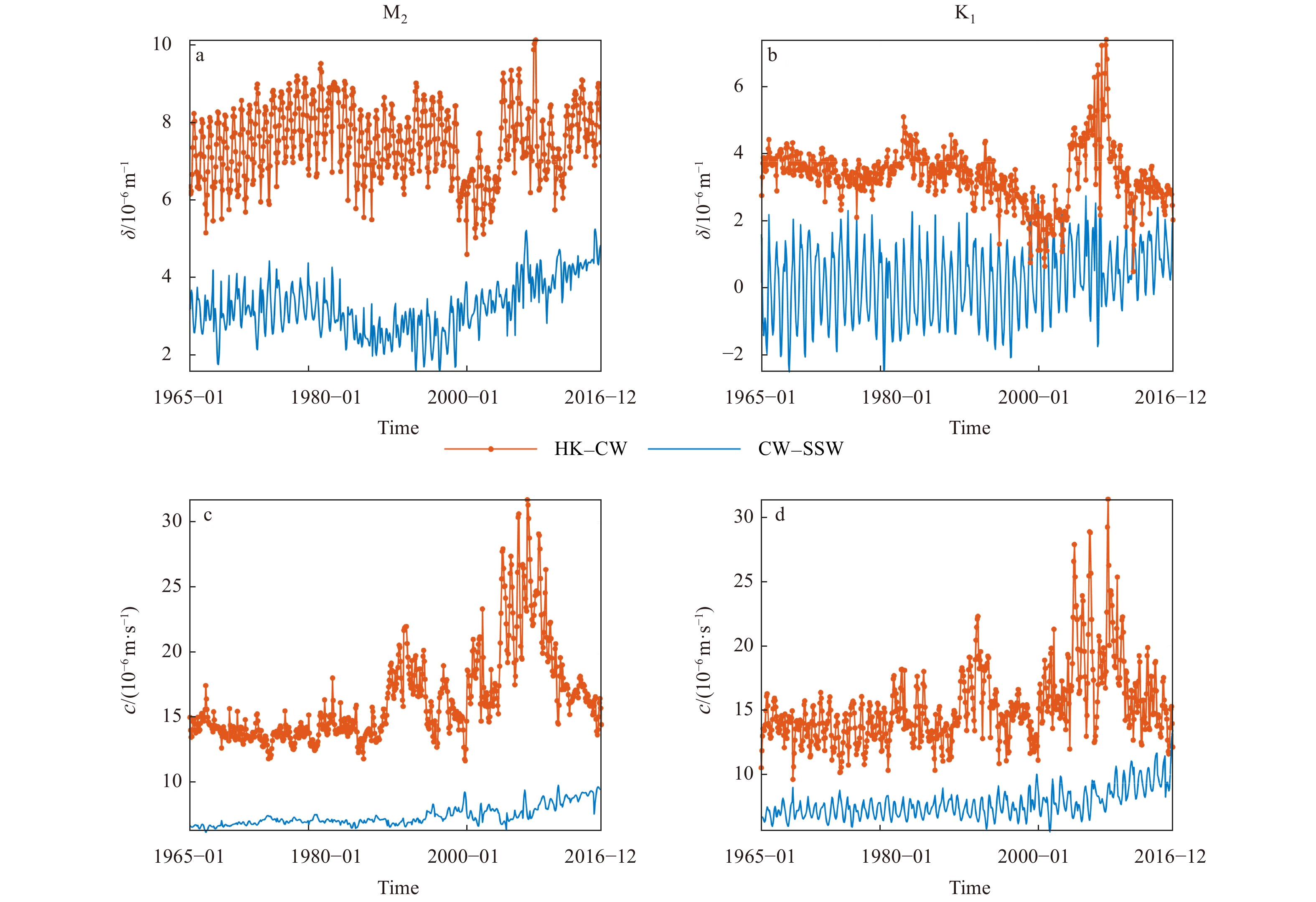
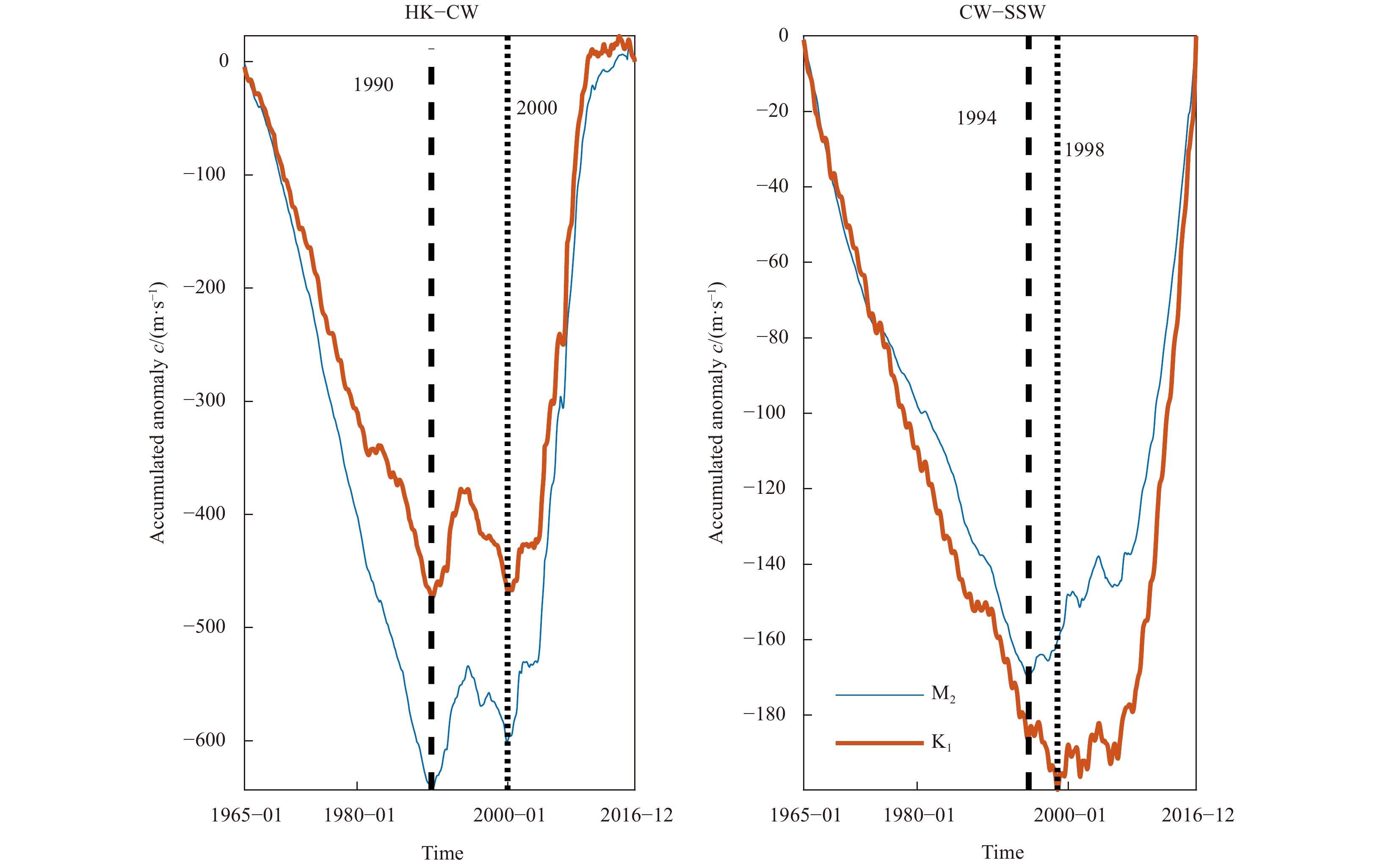
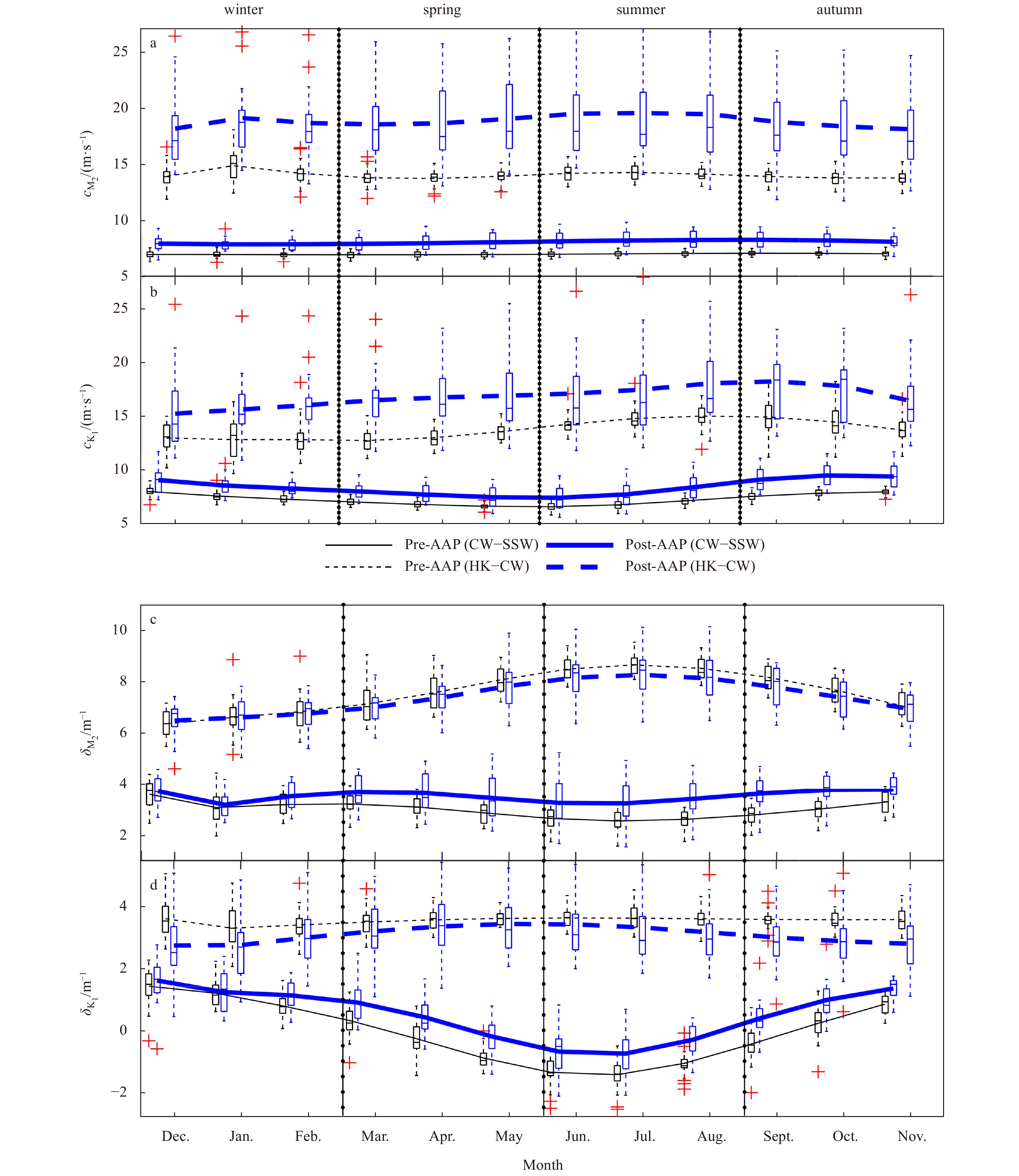
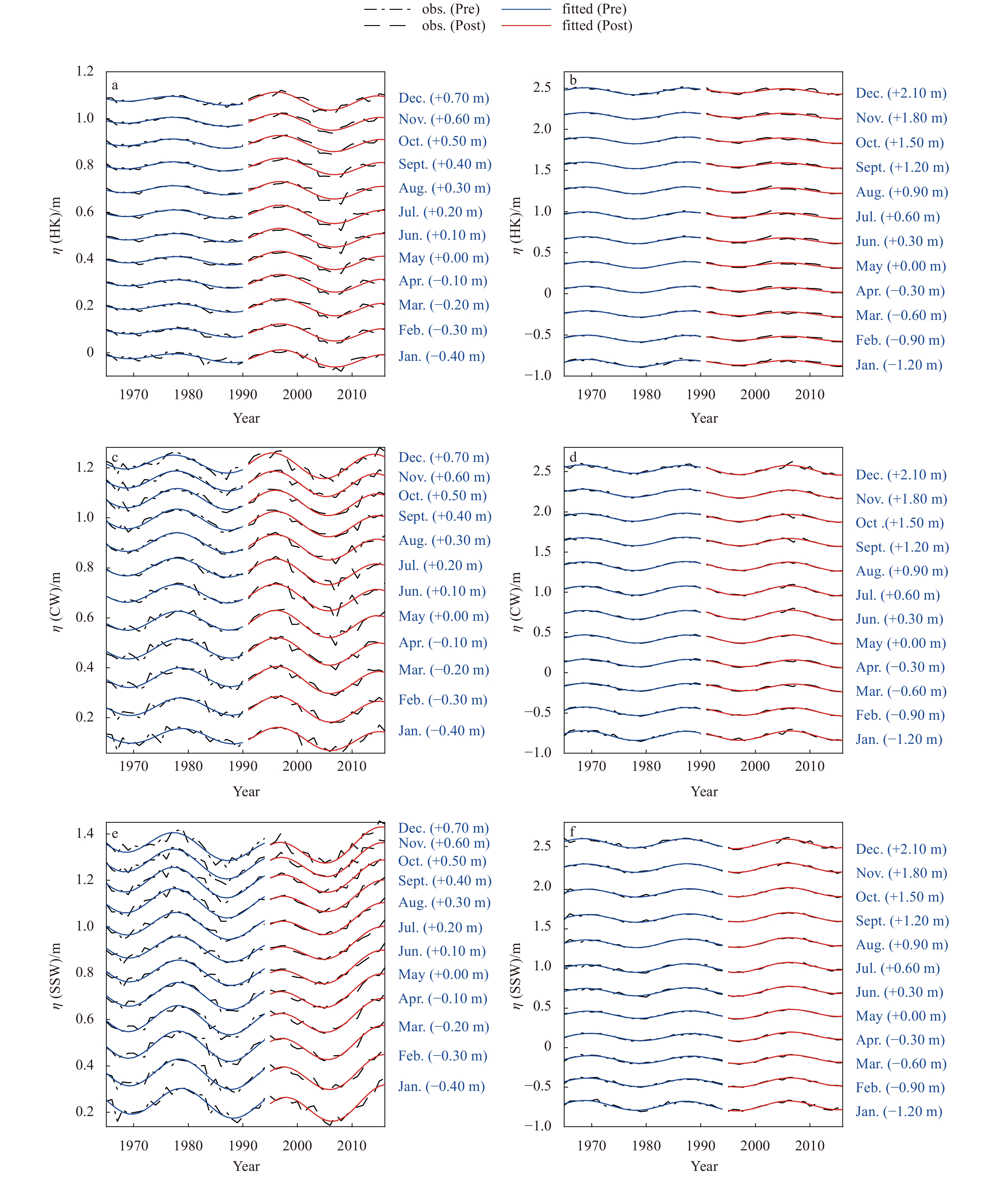
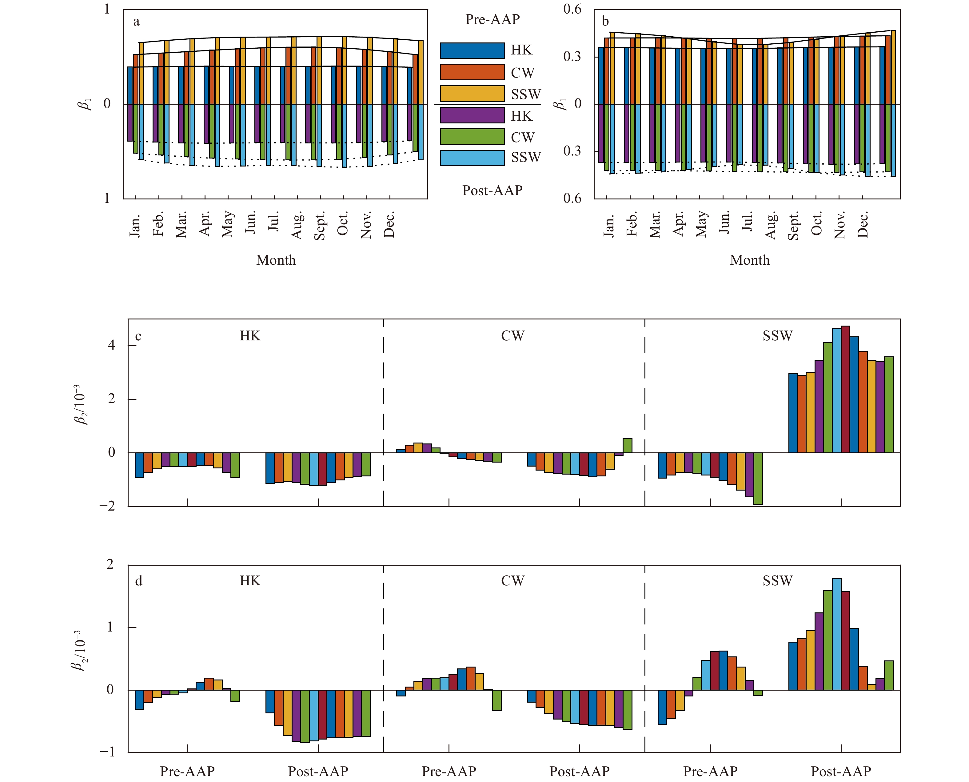
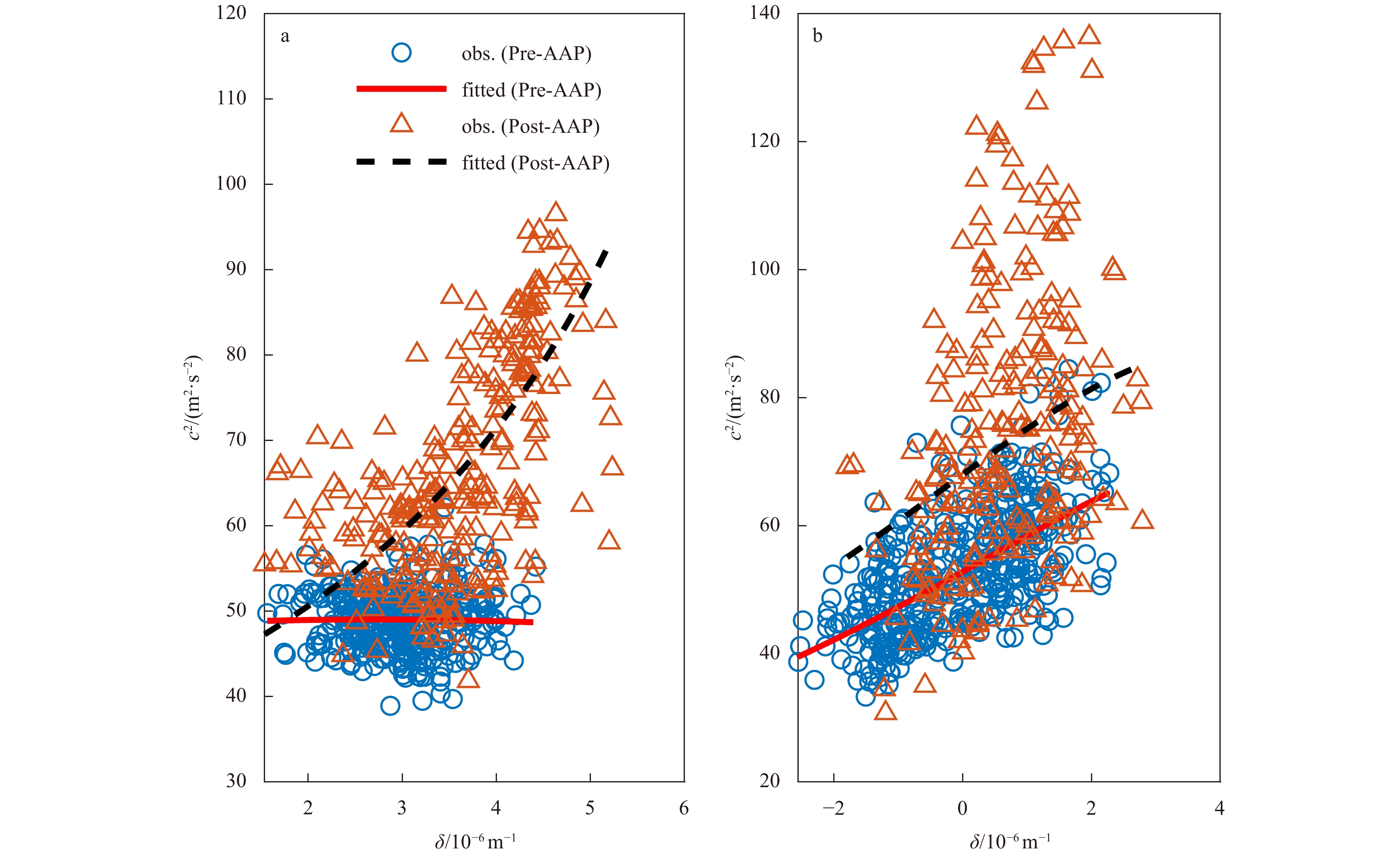
Natural and human-induced changes may exert considerable impacts on the seasonal and nodal dynamics of M2 and K1 tidal constituents. Therefore, quantifying the influences of these factors on tidal regime changes is essential for sustainable water resources management in coastal environments. In this study, the enhanced harmonic analysis was applied to extract the seasonal variability of the M2 and K1 tidal amplitudes and phases at three gauging stations along Lingdingyang Bay of the Zhujiang River Delta. The seasonal dynamics in terms of tidal wave celerity and amplification/damping rate were used to quantify the impacts of human-induced estuarine morphological alterations on M2 and K1 tidal hydrodynamics in inner and outer Lingdingyang Bay. The results show that both tidal amplification/damping rate and wave celerity were considerably increased from the pre-anthropogenic activity period (Pre-AAP) to the post-anthropogenic activity period (Post-AAP) excepting the tidal amplification/damping rate in outer Lingdingyang Bay, and the variations in outer Lingdingyang Bay was larger than those in inner Lingdingyang Bay. The alterations in these two parameters were more significant in flood season than in dry season in both inner and outer Lingdingyang Bay. The seasonal variability of M2 and K1 tidal amplitudes were further quantified using a regression model accounting for the 18.61-year lunar nodal modulation, where this study observes a considerable alteration in M2 constituent owing to human interventions. During the Post-AAP, the M2 amplitudes at the downstream station were larger than those that would have occurred in the absence of strong human interventions, whereas the opposite was true for the upstream station, leading to a substantial decrease in tidal amplification in outer Lingdingyang Bay. However, it is opposite in inner Lingdingyang Bay. The underlying mechanism can be primarily attributed to channel deepening and narrowing caused by human interventions, that resulted in substantial enlargement of the bay volume and reduced the effective bottom friction, leading to faster wave celerity and stronger amplified waves.
Natural and human-induced changes may exert considerable impacts on the seasonal and nodal dynamics of M2 and K1 tidal constituents. Therefore, quantifying the influences of these factors on tidal regime changes is essential for sustainable water resources management in coastal environments. In this study, the enhanced harmonic analysis was applied to extract the seasonal variability of the M2 and K1 tidal amplitudes and phases at three gauging stations along Lingdingyang Bay of the Zhujiang River Delta. The seasonal dynamics in terms of tidal wave celerity and amplification/damping rate were used to quantify the impacts of human-induced estuarine morphological alterations on M2 and K1 tidal hydrodynamics in inner and outer Lingdingyang Bay. The results show that both tidal amplification/damping rate and wave celerity were considerably increased from the pre-anthropogenic activity period (Pre-AAP) to the post-anthropogenic activity period (Post-AAP) excepting the tidal amplification/damping rate in outer Lingdingyang Bay, and the variations in outer Lingdingyang Bay was larger than those in inner Lingdingyang Bay. The alterations in these two parameters were more significant in flood season than in dry season in both inner and outer Lingdingyang Bay. The seasonal variability of M2 and K1 tidal amplitudes were further quantified using a regression model accounting for the 18.61-year lunar nodal modulation, where this study observes a considerable alteration in M2 constituent owing to human interventions. During the Post-AAP, the M2 amplitudes at the downstream station were larger than those that would have occurred in the absence of strong human interventions, whereas the opposite was true for the upstream station, leading to a substantial decrease in tidal amplification in outer Lingdingyang Bay. However, it is opposite in inner Lingdingyang Bay. The underlying mechanism can be primarily attributed to channel deepening and narrowing caused by human interventions, that resulted in substantial enlargement of the bay volume and reduced the effective bottom friction, leading to faster wave celerity and stronger amplified waves.


2021, 40(10): 65-75.
doi: 10.1007/s13131-021-1768-4
Abstract:
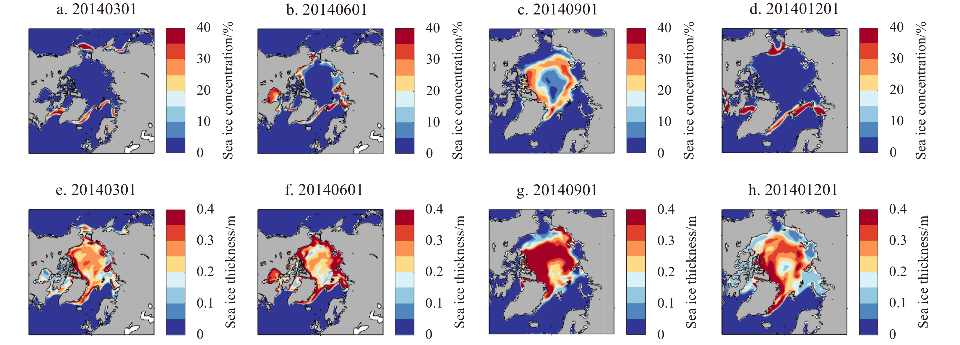
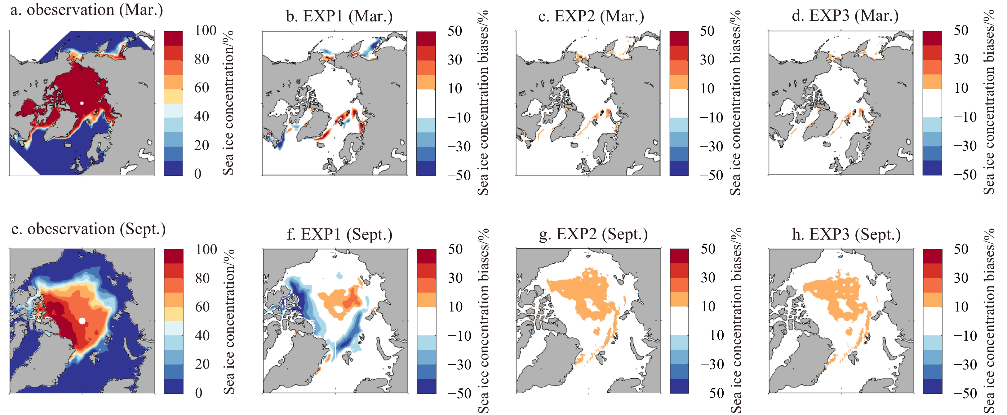
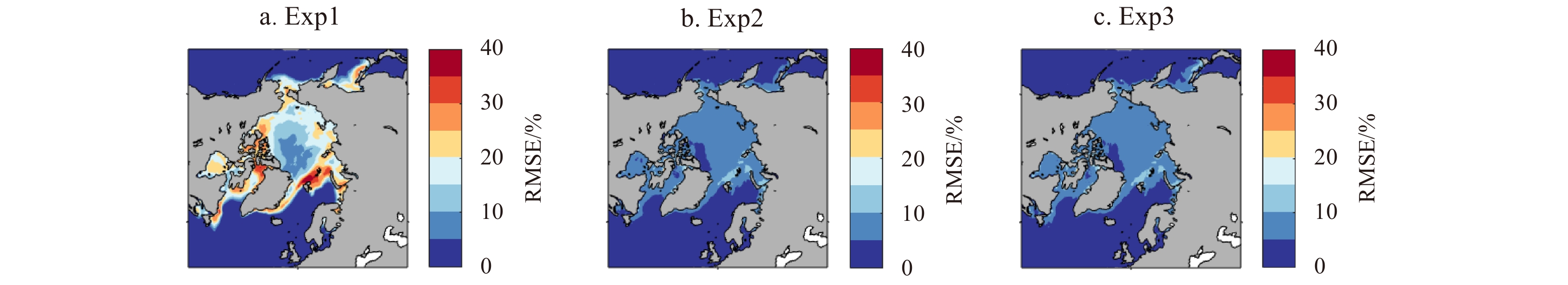
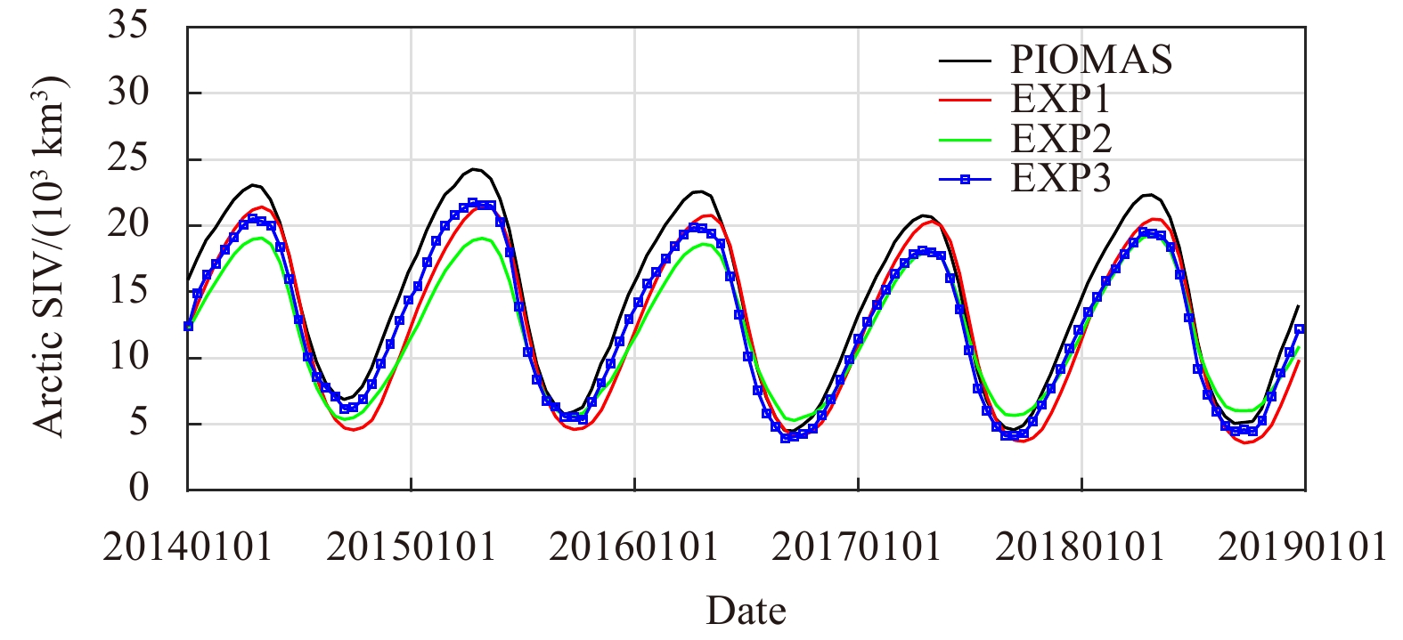
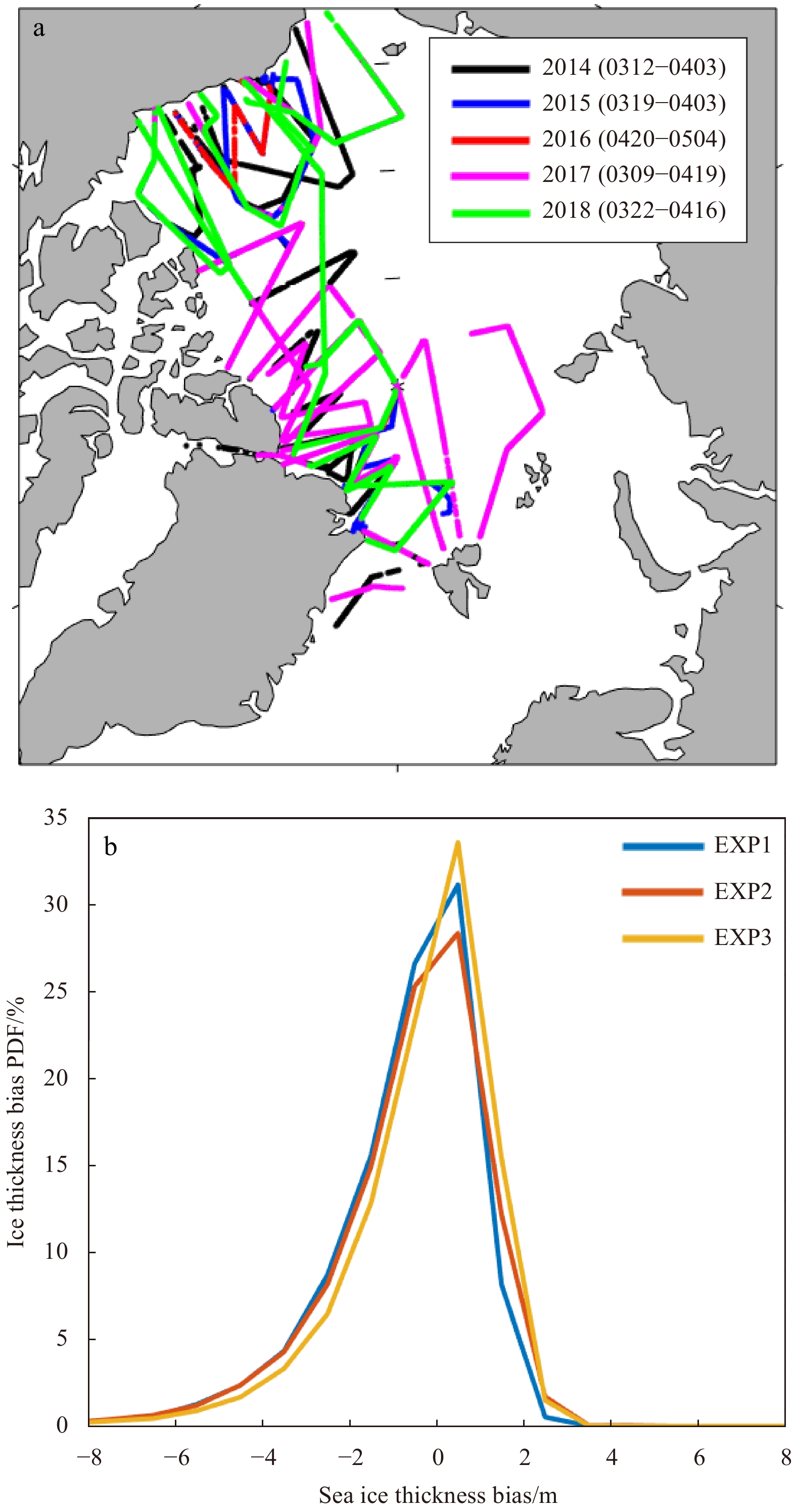
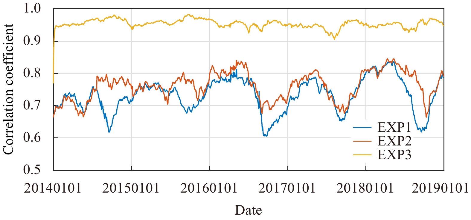
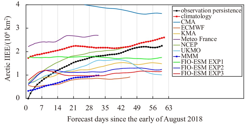
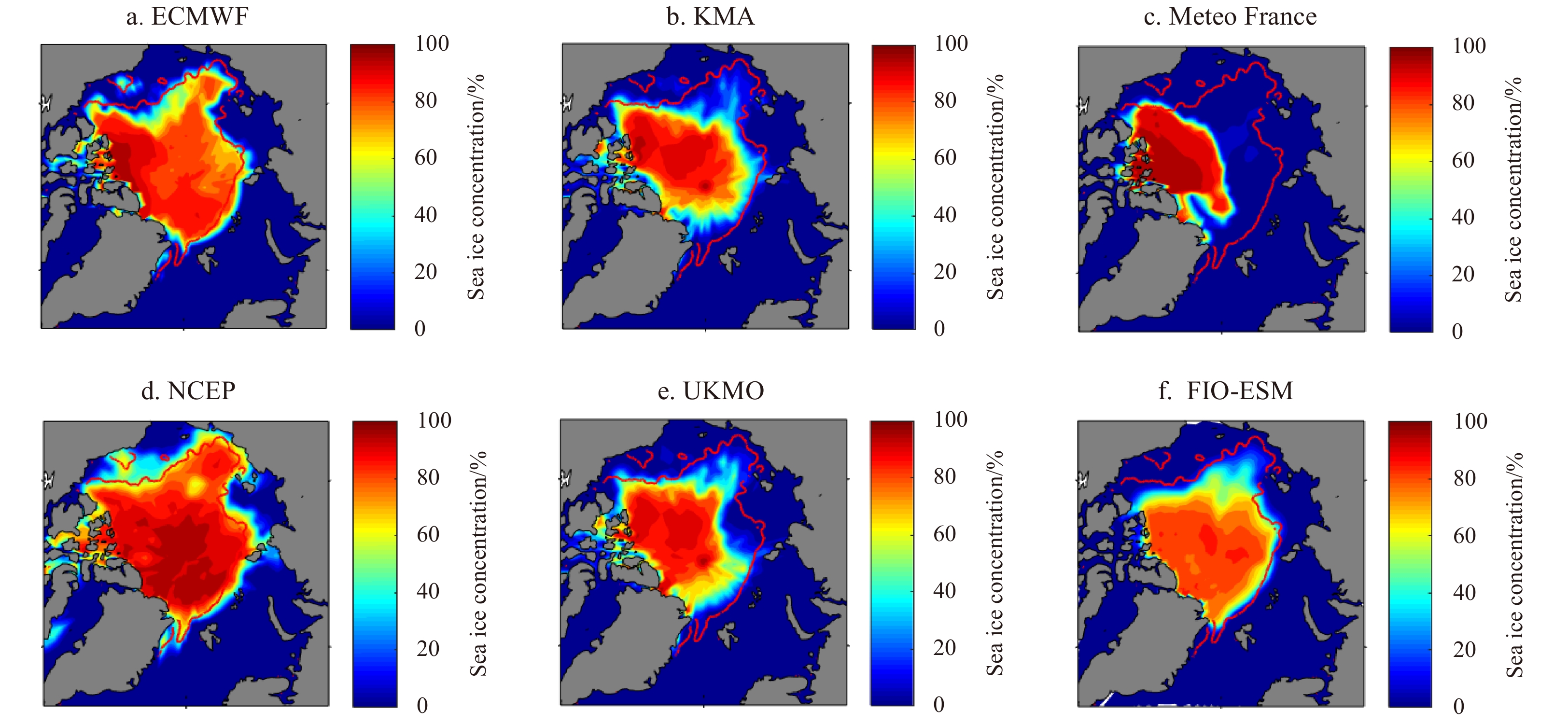
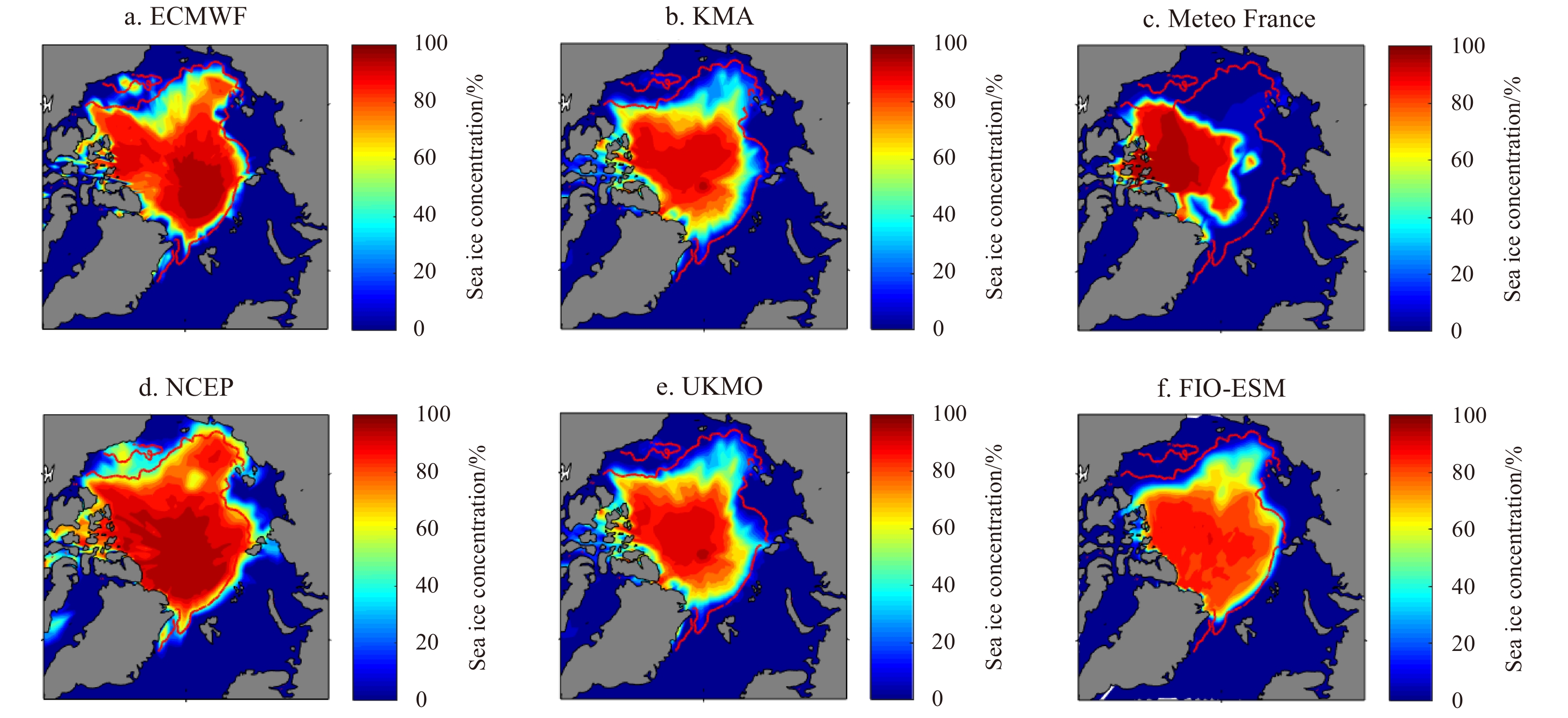
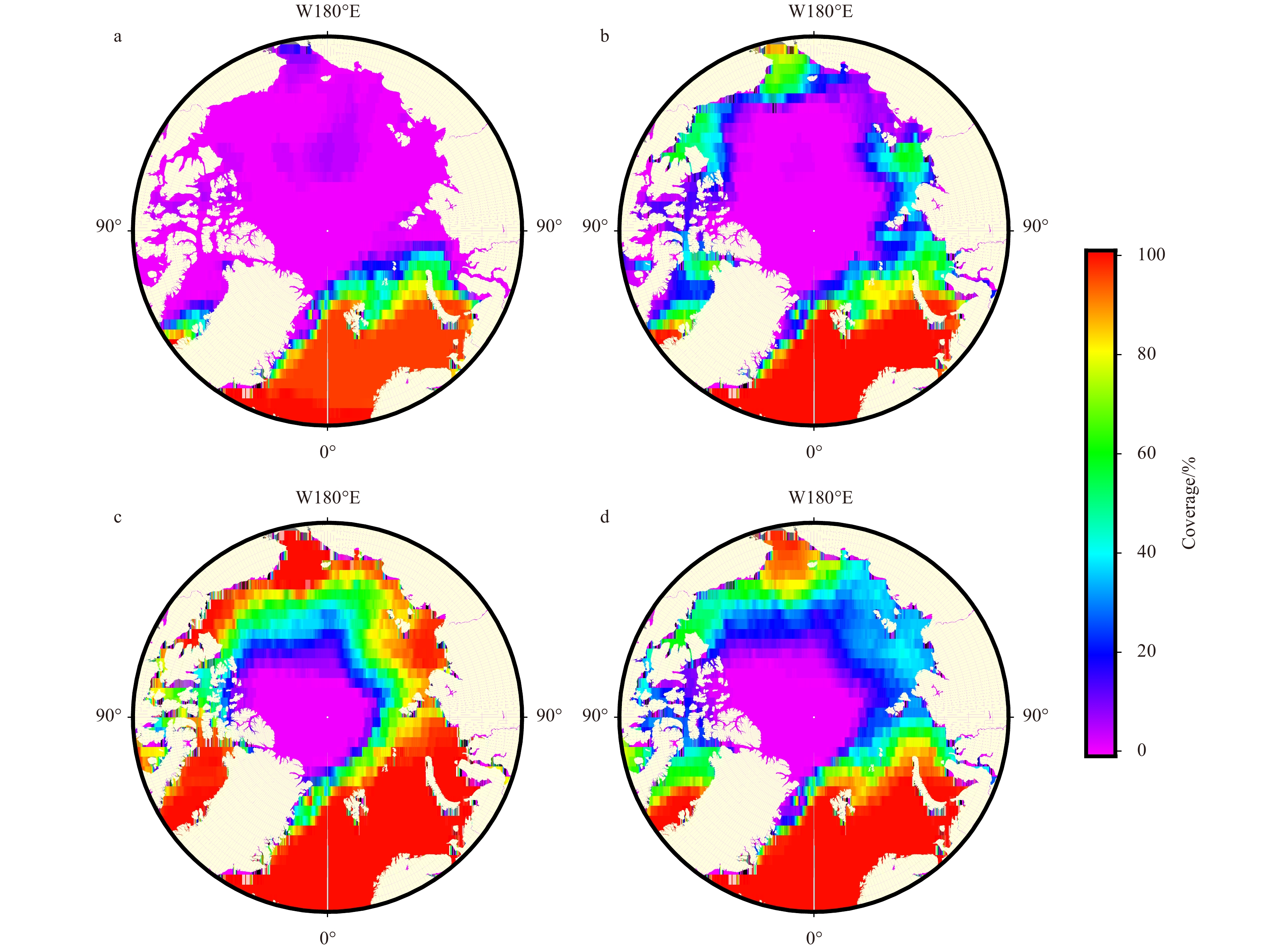
To improve the Arctic sea ice forecast skill of the First Institute of Oceanography-Earth System Model (FIO-ESM) climate forecast system, satellite-derived sea ice concentration and sea ice thickness from the Pan-Arctic Ice-Ocean Modeling and Assimilation System (PIOMAS) are assimilated into this system, using the method of localized error subspace transform ensemble Kalman filter (LESTKF). Five-year (2014–2018) Arctic sea ice assimilation experiments and a 2-month near-real-time forecast in August 2018 were conducted to study the roles of ice data assimilation. Assimilation experiment results show that ice concentration assimilation can help to get better modeled ice concentration and ice extent. All the biases of ice concentration, ice cover, ice volume, and ice thickness can be reduced dramatically through ice concentration and thickness assimilation. The near-real-time forecast results indicate that ice data assimilation can improve the forecast skill significantly in the FIO-ESM climate forecast system. The forecasted Arctic integrated ice edge error is reduced by around 1/3 by sea ice data assimilation. Compared with the six near-real-time Arctic sea ice forecast results from the subseasonal-to-seasonal (S2S) Prediction Project, FIO-ESM climate forecast system with LESTKF ice data assimilation has relatively high Arctic sea ice forecast skill in 2018 summer sea ice forecast. Since sea ice thickness in the PIOMAS is updated in time, it is a good choice for data assimilation to improve sea ice prediction skills in the near-real-time Arctic sea ice seasonal prediction.
To improve the Arctic sea ice forecast skill of the First Institute of Oceanography-Earth System Model (FIO-ESM) climate forecast system, satellite-derived sea ice concentration and sea ice thickness from the Pan-Arctic Ice-Ocean Modeling and Assimilation System (PIOMAS) are assimilated into this system, using the method of localized error subspace transform ensemble Kalman filter (LESTKF). Five-year (2014–2018) Arctic sea ice assimilation experiments and a 2-month near-real-time forecast in August 2018 were conducted to study the roles of ice data assimilation. Assimilation experiment results show that ice concentration assimilation can help to get better modeled ice concentration and ice extent. All the biases of ice concentration, ice cover, ice volume, and ice thickness can be reduced dramatically through ice concentration and thickness assimilation. The near-real-time forecast results indicate that ice data assimilation can improve the forecast skill significantly in the FIO-ESM climate forecast system. The forecasted Arctic integrated ice edge error is reduced by around 1/3 by sea ice data assimilation. Compared with the six near-real-time Arctic sea ice forecast results from the subseasonal-to-seasonal (S2S) Prediction Project, FIO-ESM climate forecast system with LESTKF ice data assimilation has relatively high Arctic sea ice forecast skill in 2018 summer sea ice forecast. Since sea ice thickness in the PIOMAS is updated in time, it is a good choice for data assimilation to improve sea ice prediction skills in the near-real-time Arctic sea ice seasonal prediction.


2021, 40(10): 76-83.
doi: 10.1007/s13131-021-1820-4
Abstract:
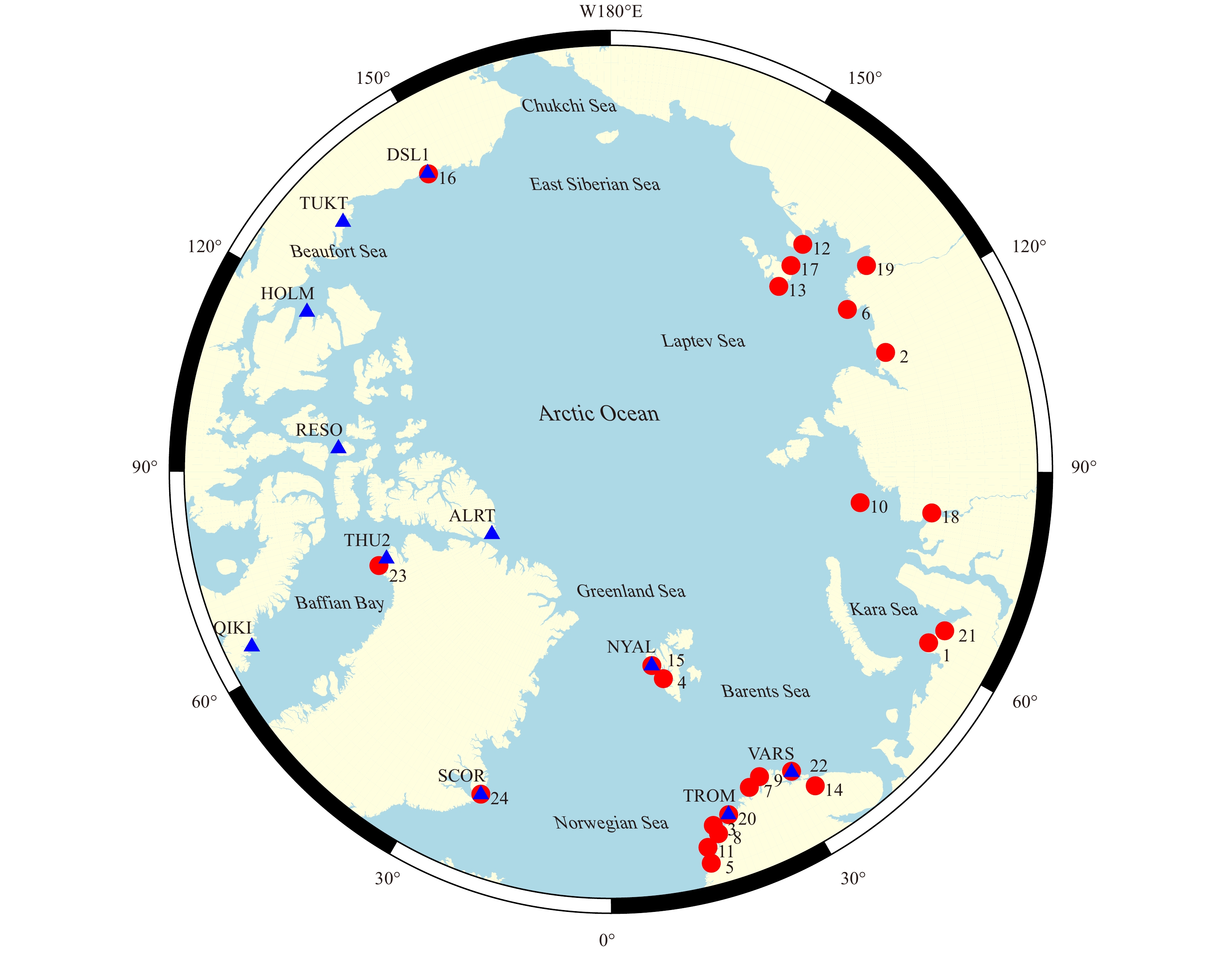
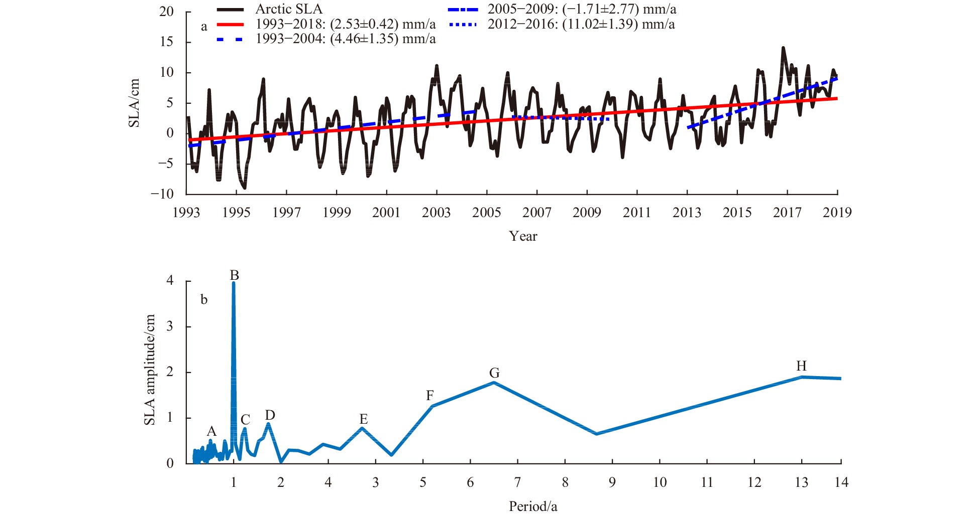
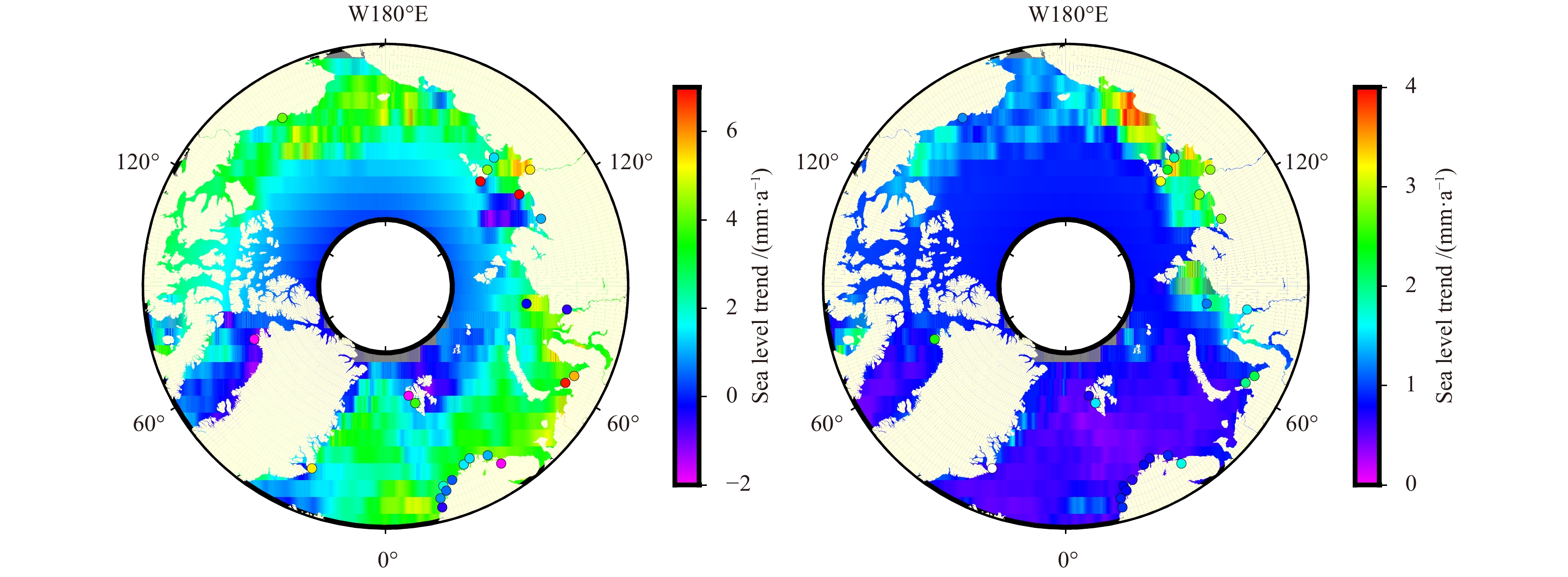
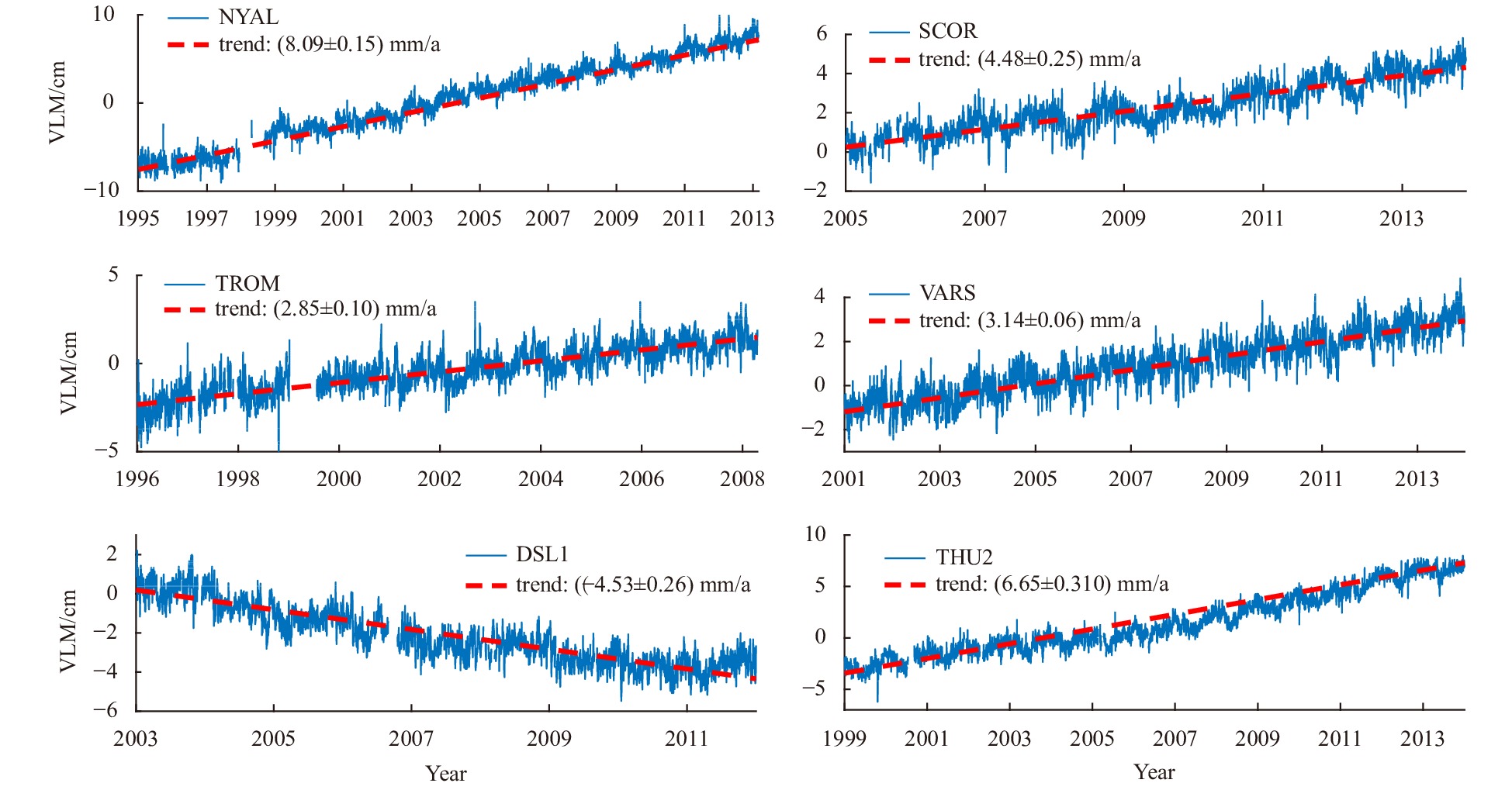
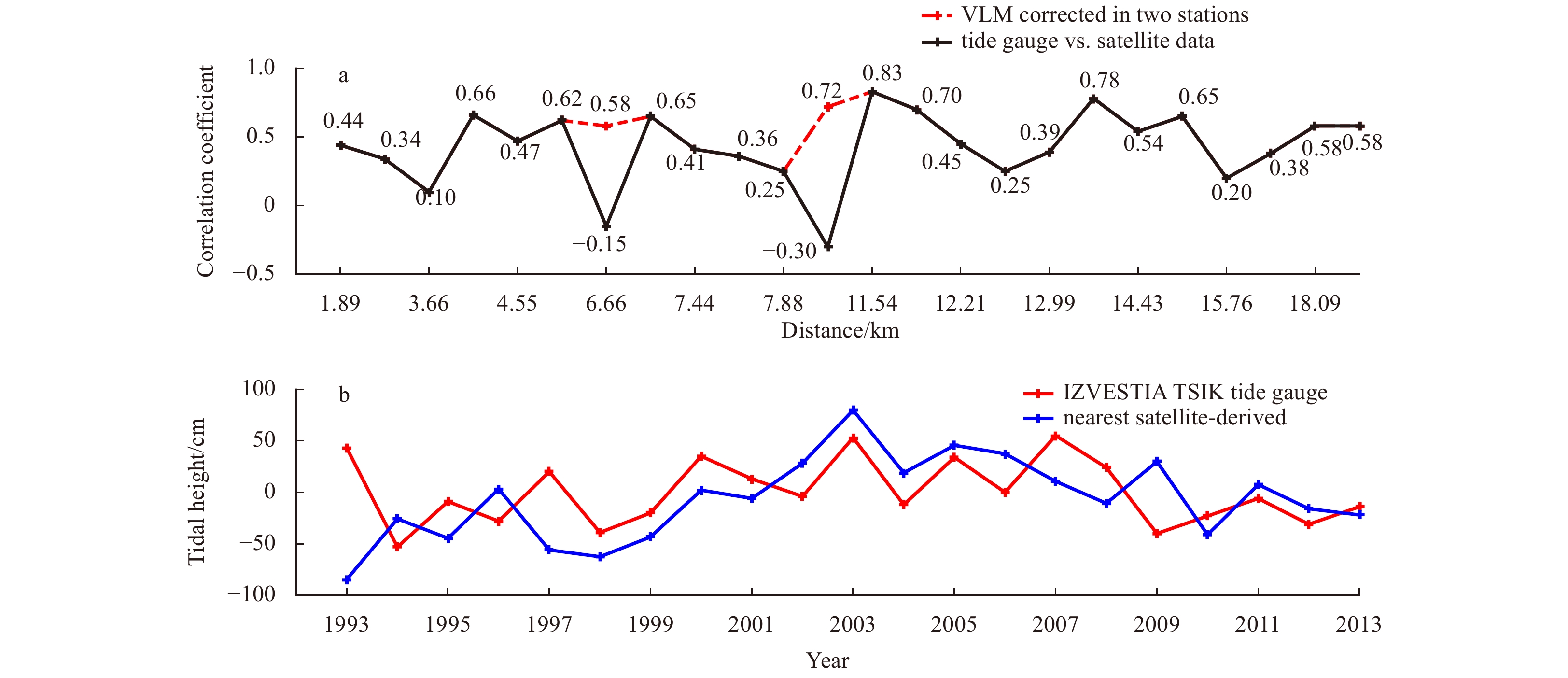
Arctic absolute sea level variations were analyzed based on multi-mission satellite altimetry data and tide gauge observations for the period of 1993–2018. The range of linear absolute sea level trends were found −2.00 mm/a to 6.88 mm/a excluding the central Arctic, positive trend rates were predominantly located in shallow water and coastal areas, and negative rates were located in high-latitude areas and Baffin Bay. Satellite-derived results show that the average secular absolute sea level trend was (2.53±0.42) mm/a in the Arctic region. Large differences were presented between satellite-derived and tide gauge results, which are mainly due to low satellite data coverage, uncertainties in tidal height processing and vertical land movement (VLM). The VLM rates at 11 global navigation satellite system stations around the Arctic Ocean were analyzed, among which 6 stations were tide gauge co-located, the results indicate that the absolute sea level trends after VLM corrected were of the same magnitude as satellite altimetry results. Accurately calculating VLM is the primary uncertainty in interpreting tide gauge measurements such that differences between tide gauge and satellite altimetry data are attributable generally to VLM.
Arctic absolute sea level variations were analyzed based on multi-mission satellite altimetry data and tide gauge observations for the period of 1993–2018. The range of linear absolute sea level trends were found −2.00 mm/a to 6.88 mm/a excluding the central Arctic, positive trend rates were predominantly located in shallow water and coastal areas, and negative rates were located in high-latitude areas and Baffin Bay. Satellite-derived results show that the average secular absolute sea level trend was (2.53±0.42) mm/a in the Arctic region. Large differences were presented between satellite-derived and tide gauge results, which are mainly due to low satellite data coverage, uncertainties in tidal height processing and vertical land movement (VLM). The VLM rates at 11 global navigation satellite system stations around the Arctic Ocean were analyzed, among which 6 stations were tide gauge co-located, the results indicate that the absolute sea level trends after VLM corrected were of the same magnitude as satellite altimetry results. Accurately calculating VLM is the primary uncertainty in interpreting tide gauge measurements such that differences between tide gauge and satellite altimetry data are attributable generally to VLM.
2021, 40(10): 84-96.
doi: 10.1007/s13131-021-1828-9
Abstract:
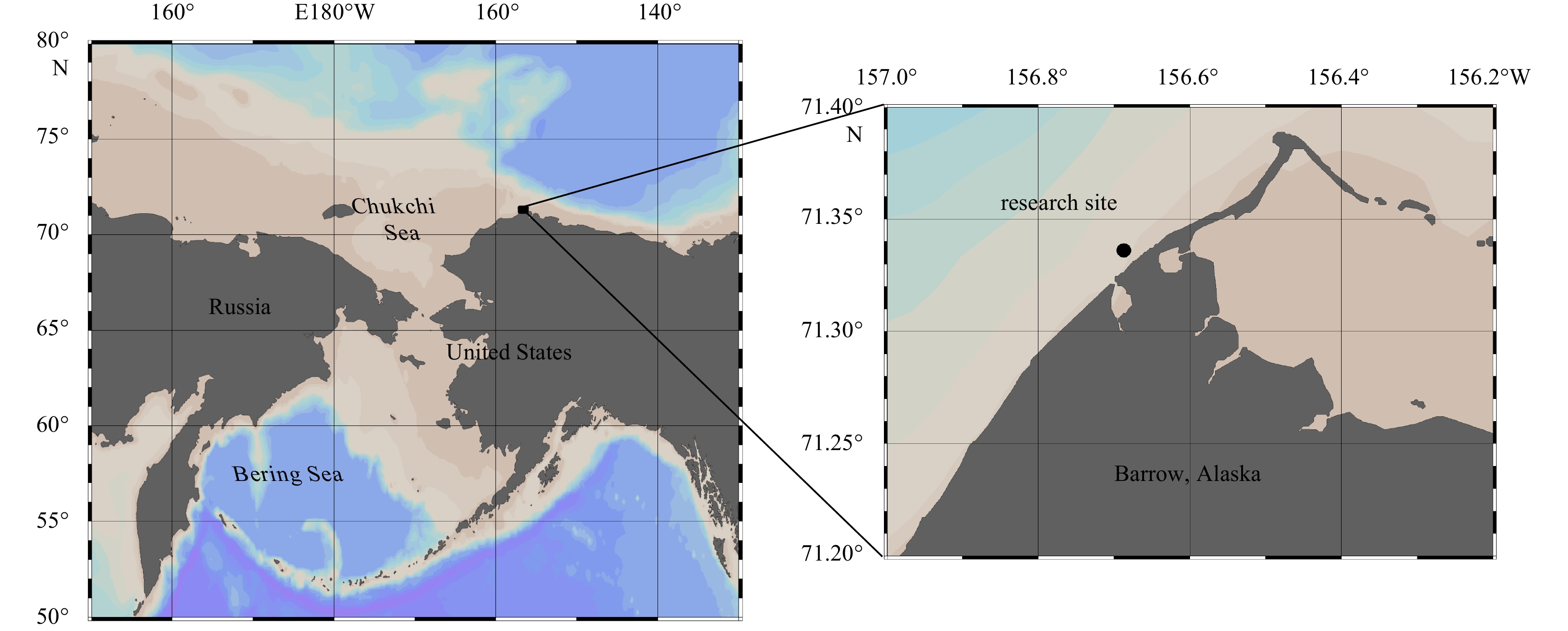
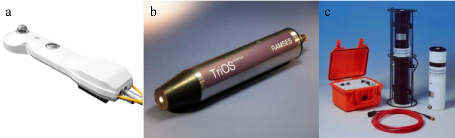
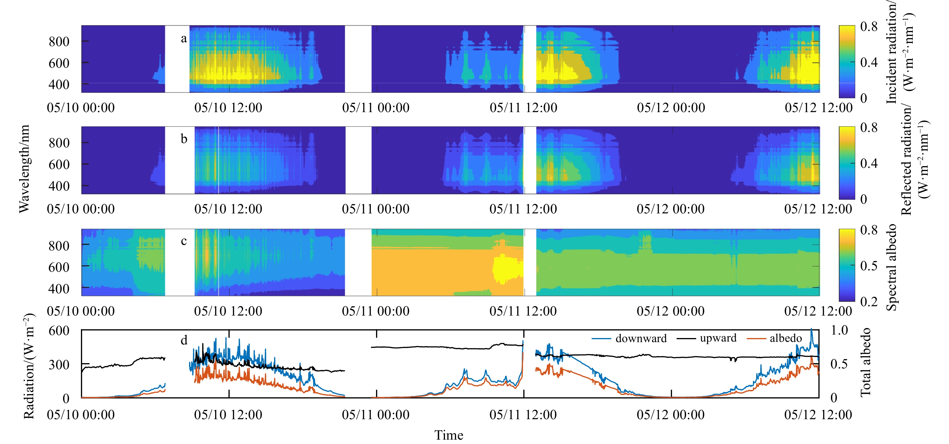
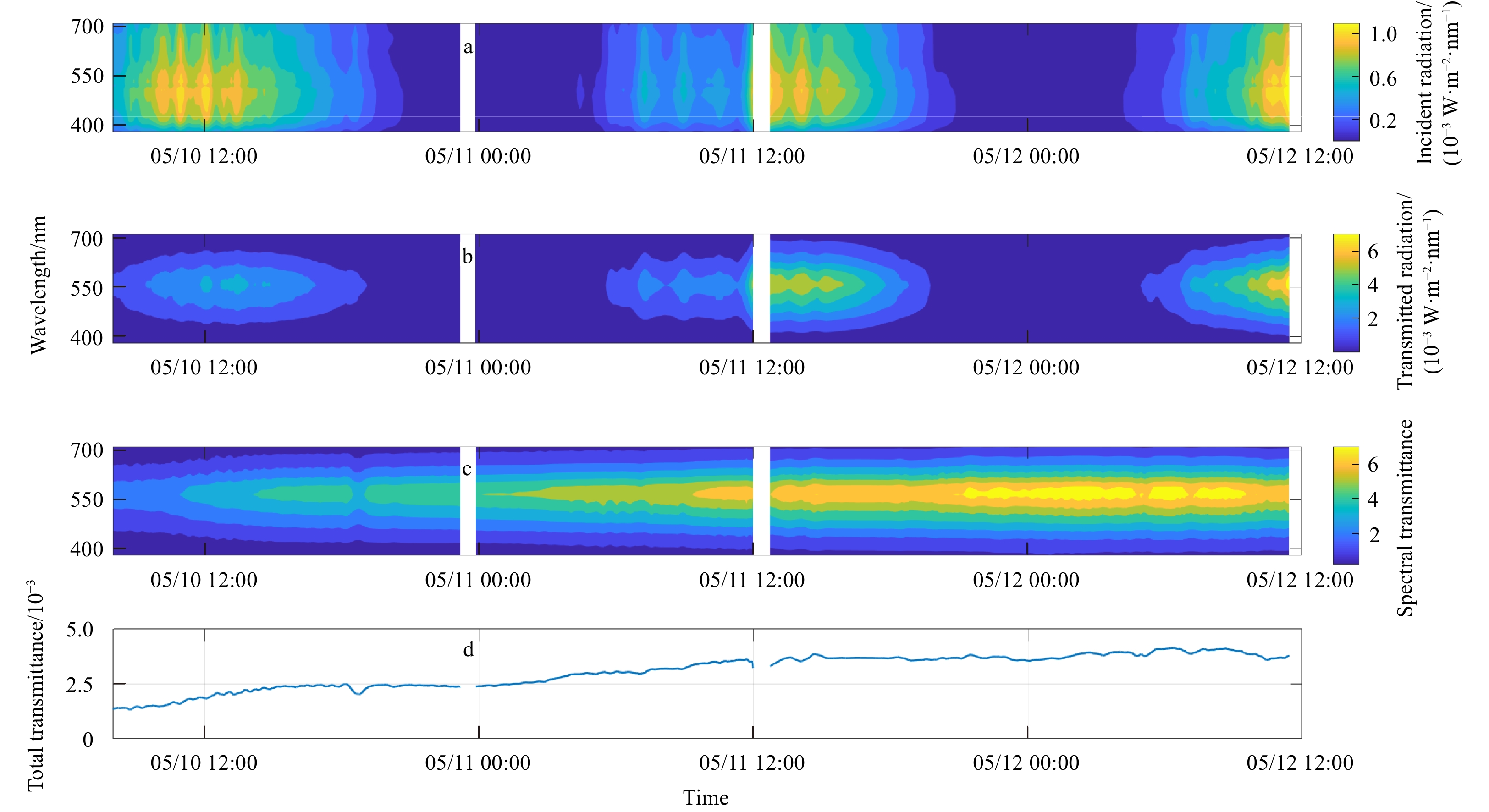
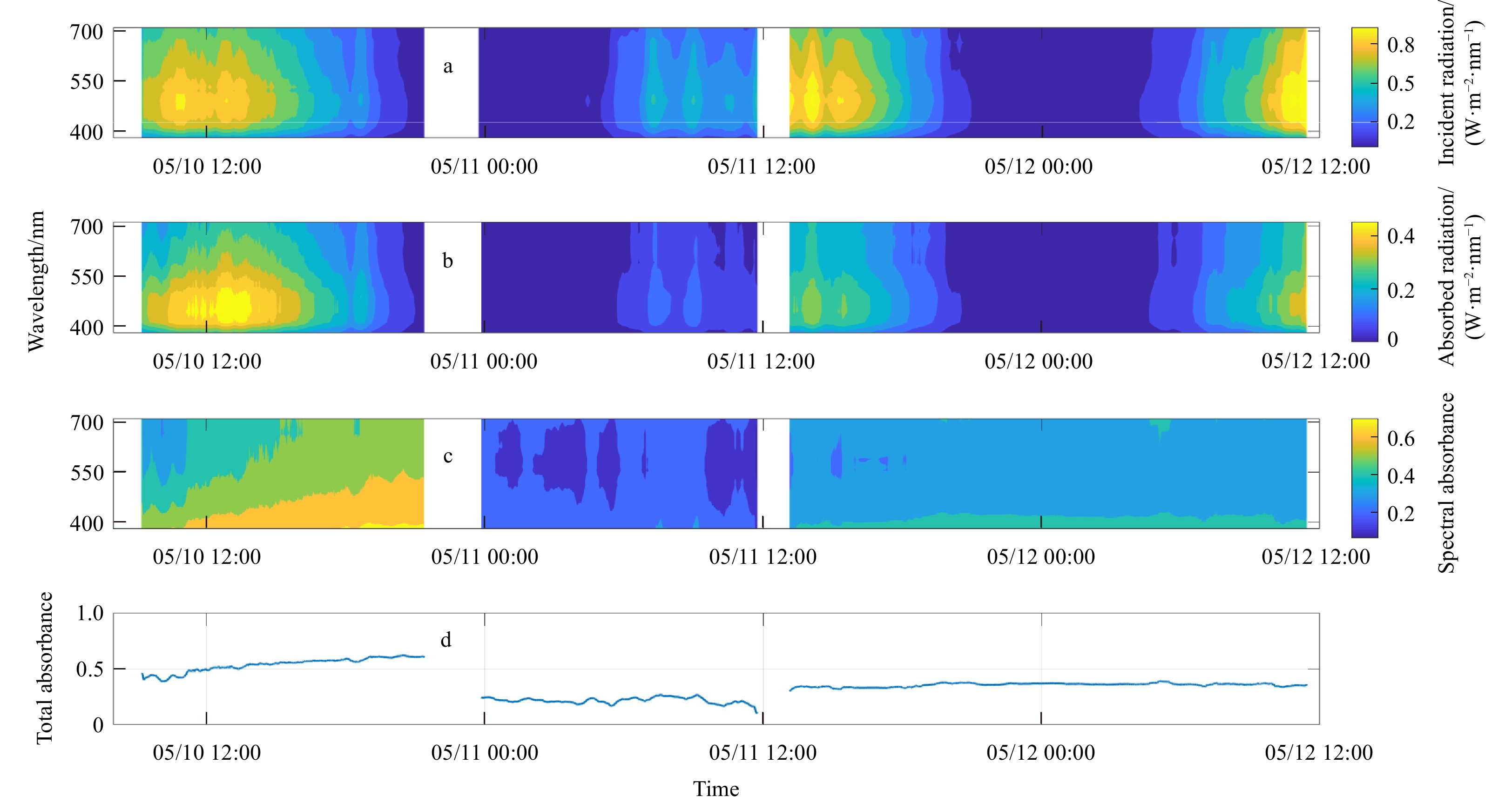
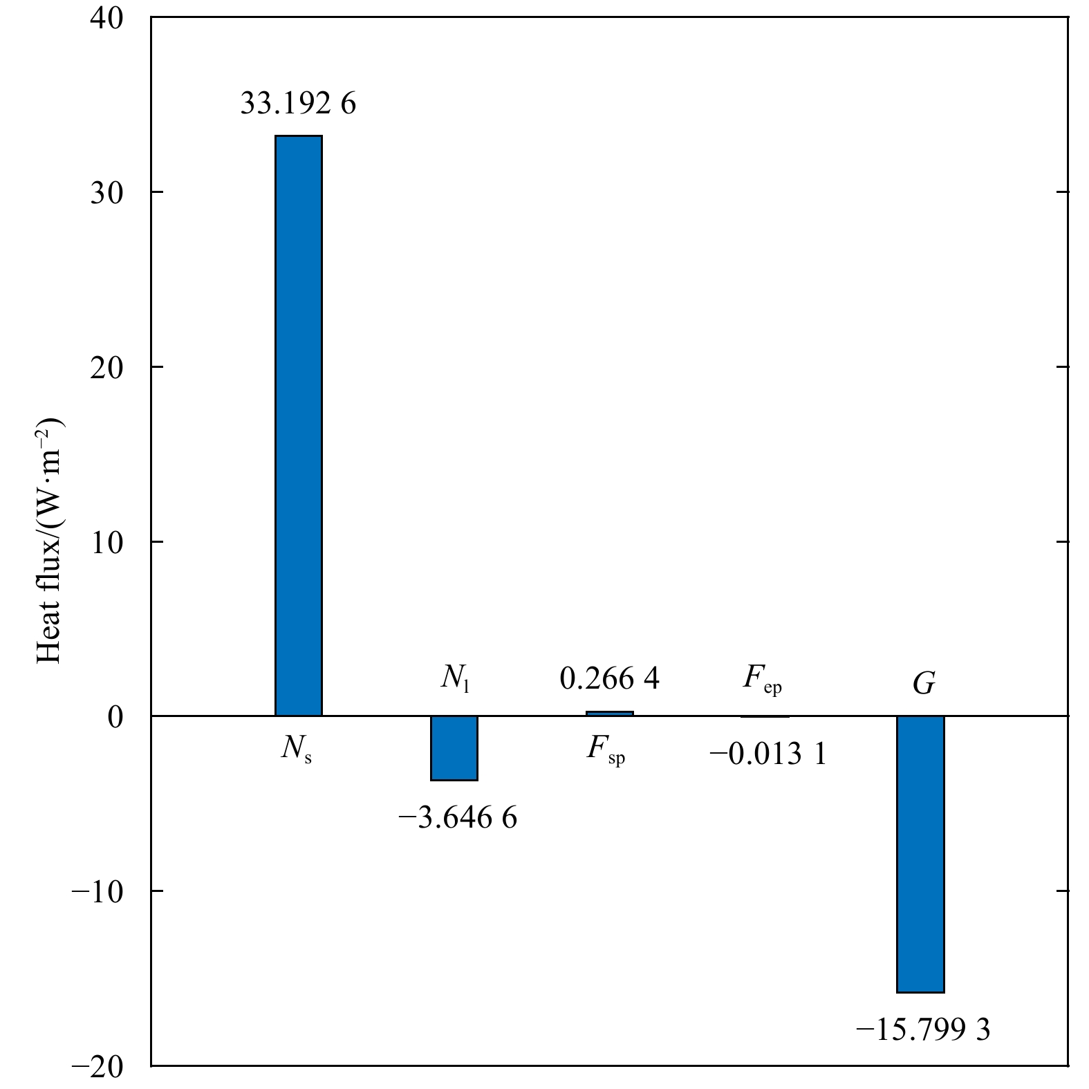
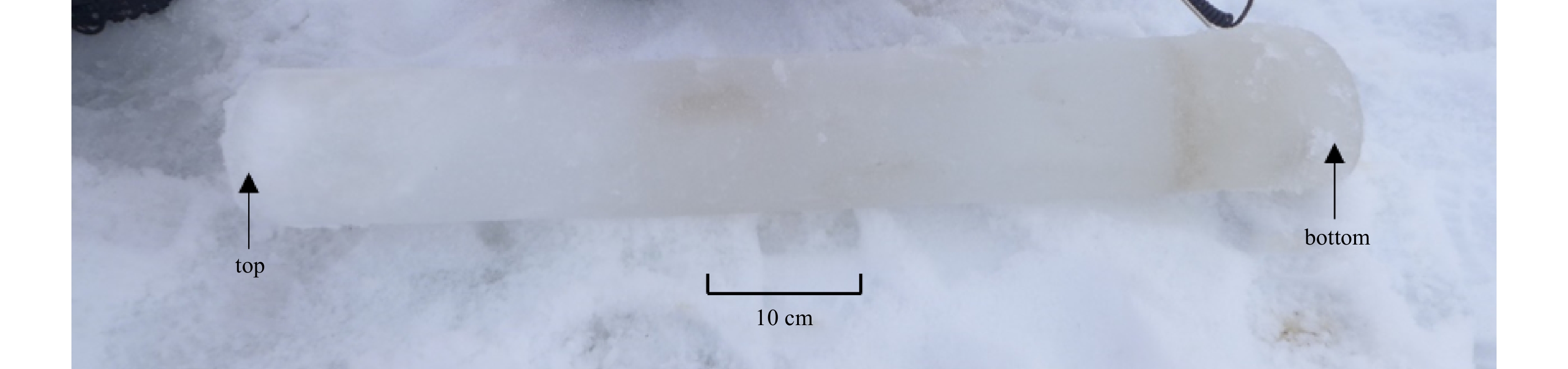
Over the past decades, sea ice in the polar regions has been significantly affecting local and even hemispheric climate through a positive ice albedo feedback mechanism. The role of fast ice, as opposed to drift ice, has not been well-studied due to its relatively small coverage over the earth. In this paper, the optical properties and surface energy balance of land fast ice in spring are studied using in situ observations in Barrow, Alaska. The results show that the albedo of the fast ice varied between 0.57 and 0.85 while the transmittance increased from 1.3×10⁻³ to 4.1×10⁻³ during the observation period. Snowfall and air temperature affected the albedo and absorbance of sea ice, but the transmittance had no obvious relationship with precipitation or snow cover. Net solar shortwave radiation contributes to the surface energy balance with a positive 99.2% of the incident flux, with sensible heat flux for the remaining 0.8%. Meanwhile, the ice surface loses energy through the net longwave radiation by 18.7% of the total emission, while the latent heat flux accounts for only 0.1%. Heat conduction is also an important factor in the overall energy budget of sea ice, contributing 81.2% of the energy loss. Results of the radiative transfer model reveal that the spectral transmittance of the fast ice is determined by the thickness of snow and sea ice as well as the amount of inclusions. As major inclusions, the ice biota and particulates have a significant influence on the magnitude and distribution of the spectral transmittance. Based on the radiative transfer model, concentrations of chlorophyll and particulate in the fast ice are estimated at 5.51 mg/m2 and 95.79 g/m2, which are typical values in the spring in Barrow.
Over the past decades, sea ice in the polar regions has been significantly affecting local and even hemispheric climate through a positive ice albedo feedback mechanism. The role of fast ice, as opposed to drift ice, has not been well-studied due to its relatively small coverage over the earth. In this paper, the optical properties and surface energy balance of land fast ice in spring are studied using in situ observations in Barrow, Alaska. The results show that the albedo of the fast ice varied between 0.57 and 0.85 while the transmittance increased from 1.3×10⁻³ to 4.1×10⁻³ during the observation period. Snowfall and air temperature affected the albedo and absorbance of sea ice, but the transmittance had no obvious relationship with precipitation or snow cover. Net solar shortwave radiation contributes to the surface energy balance with a positive 99.2% of the incident flux, with sensible heat flux for the remaining 0.8%. Meanwhile, the ice surface loses energy through the net longwave radiation by 18.7% of the total emission, while the latent heat flux accounts for only 0.1%. Heat conduction is also an important factor in the overall energy budget of sea ice, contributing 81.2% of the energy loss. Results of the radiative transfer model reveal that the spectral transmittance of the fast ice is determined by the thickness of snow and sea ice as well as the amount of inclusions. As major inclusions, the ice biota and particulates have a significant influence on the magnitude and distribution of the spectral transmittance. Based on the radiative transfer model, concentrations of chlorophyll and particulate in the fast ice are estimated at 5.51 mg/m2 and 95.79 g/m2, which are typical values in the spring in Barrow.


2021, 40(10): 97-105.
doi: 10.1007/s13131-021-1890-3
Abstract:
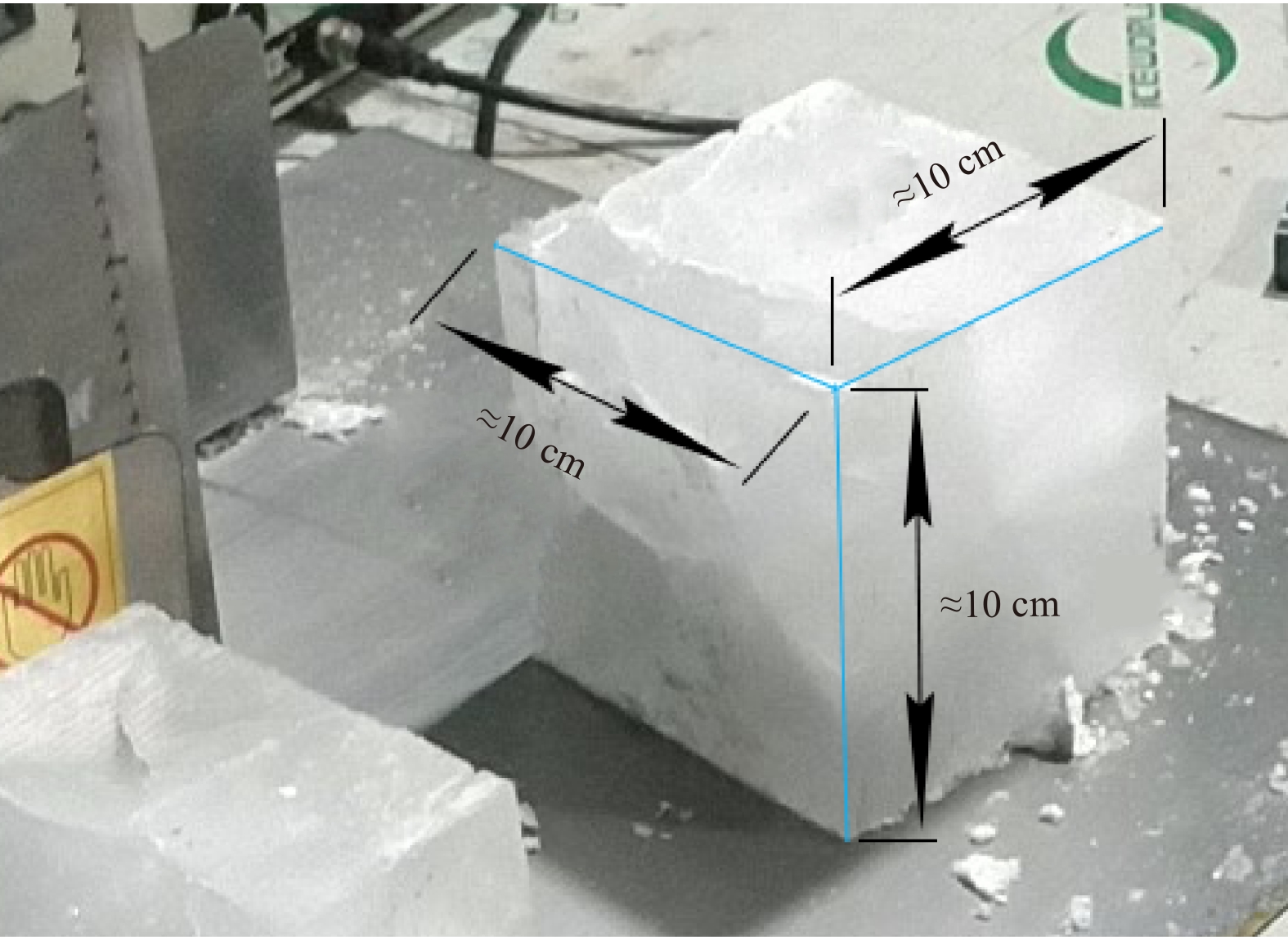
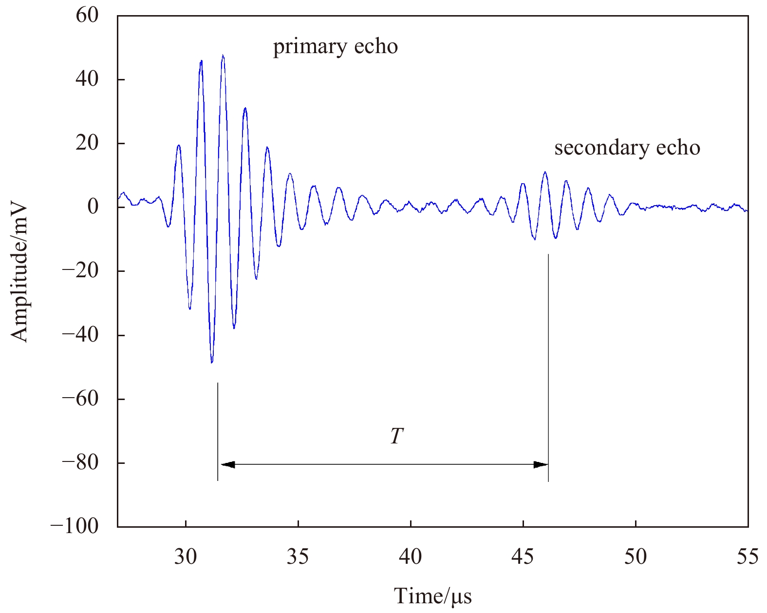
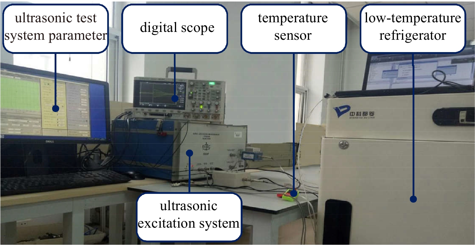
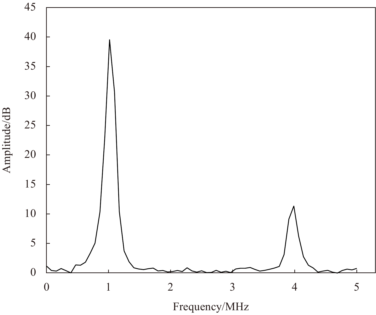
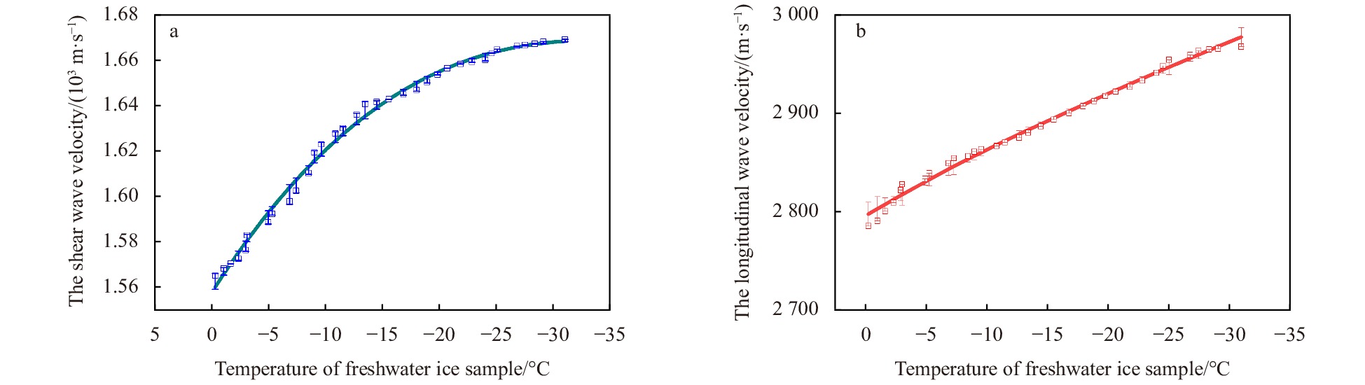
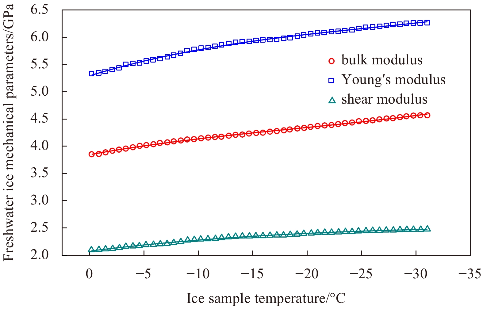
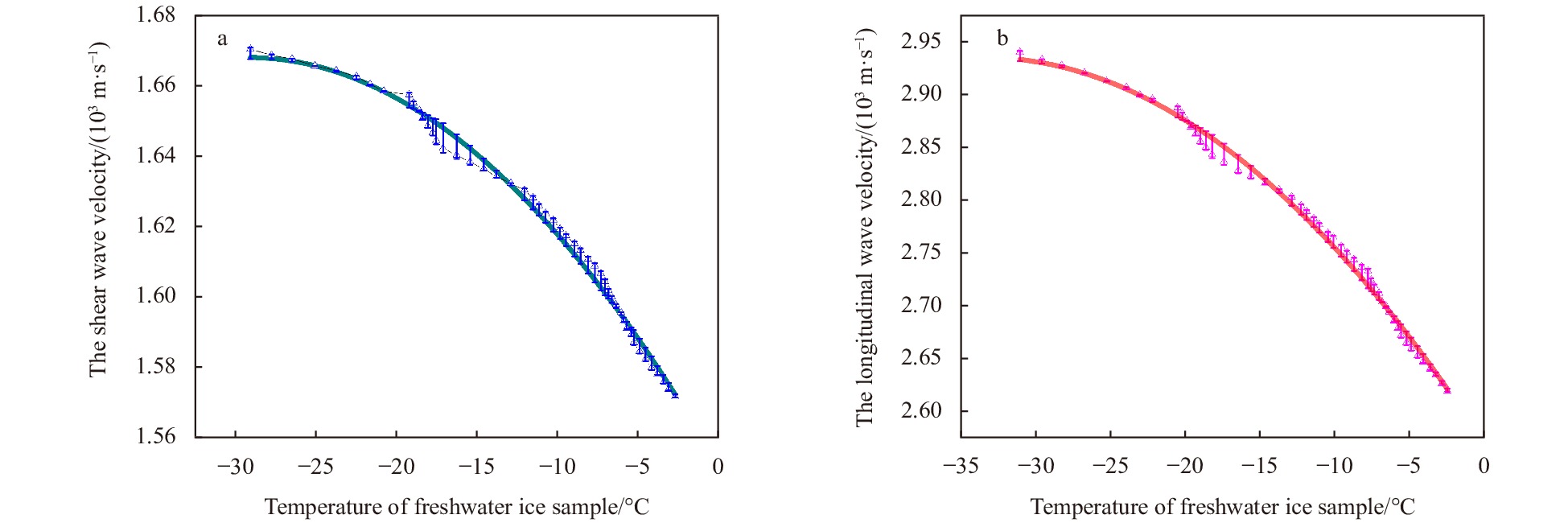
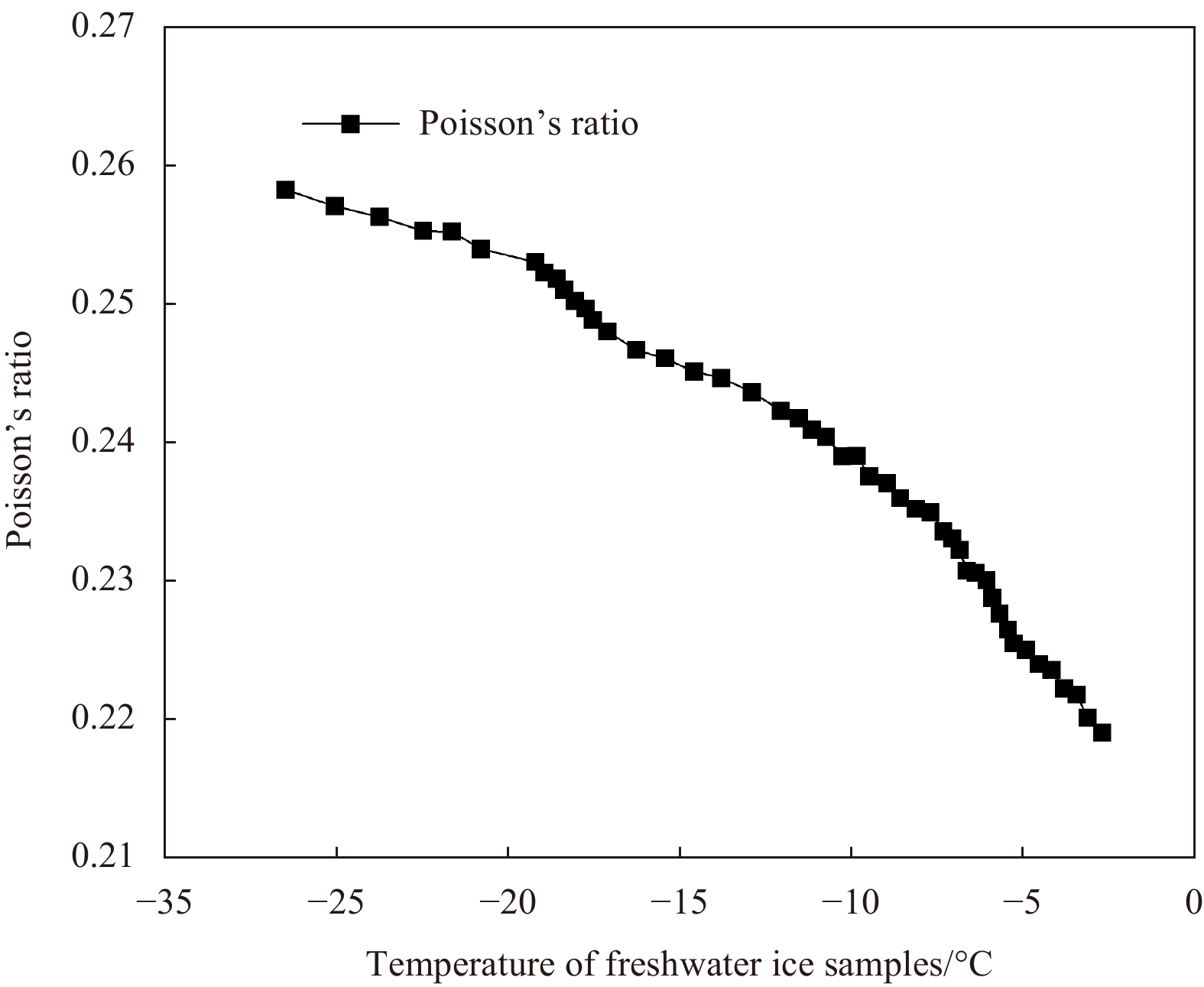
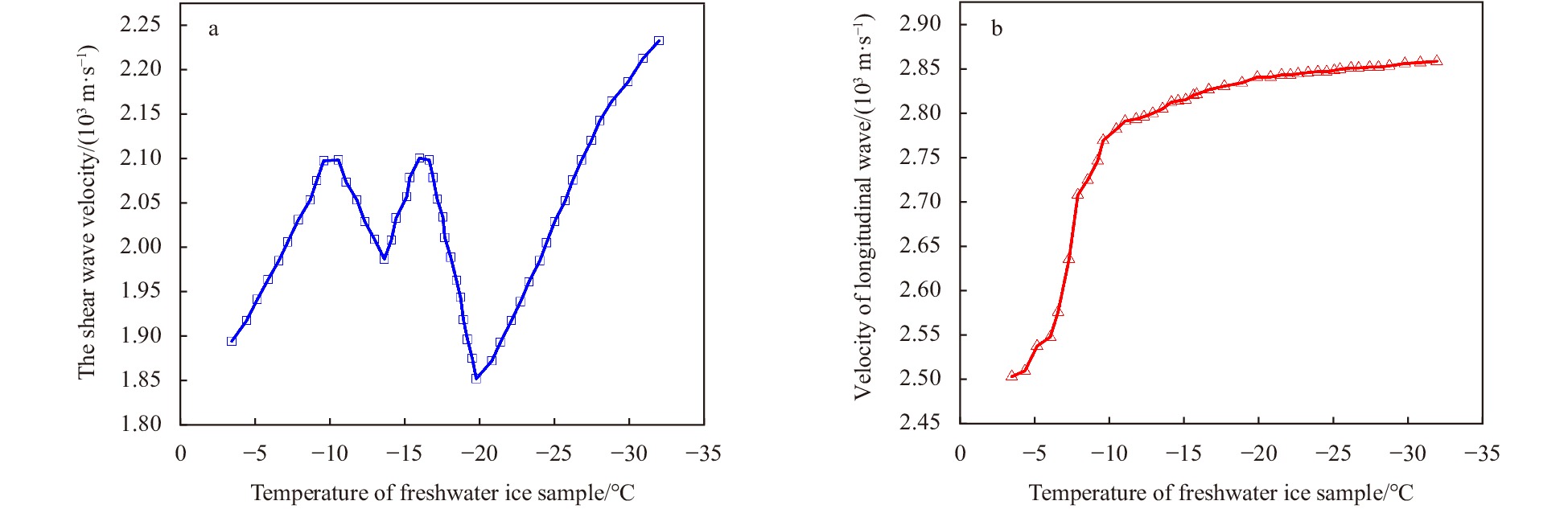
Arctic sea ice area and thickness have declined dramatically during the recent decades. Sea ice physical and mechanical properties become increasingly important. Traditional methods of studying ice mechanical parameters such as ice-coring cannot realize field test and long-term observation. A new principle of measuring mechanical properties of ice using ultrasonic was studied and an ultrasonic system was proposed to achieve automatic observation of ice mechanical parameters (Young’s modulus, shear modulus and bulk modulus). The ultrasonic system can measure the ultrasonic velocity through ice at different temperature, salinity and density of ice. When ambient temperature decreased from 0°C to −30°C, ultrasonic velocity and mechanical properties of ice increased, and vice versa. The shear modulus of the freshwater ice and sea ice varied from 2.098 GPa to 2.48 GPa and 2.927 GPa to 4.374 GPa, respectively. The bulk modulus of freshwater ice remained between 3.074 GPa and 4.566 GPa and the sea ice bulk modulus varied from 1.211 GPa to 3.089 GPa. The freshwater ice Young’s modulus kept between 5.156 GPa and 6.264 GPa and sea ice Young’s modulus varied from 3.793 GPa to 7.492 GPa. The results of ultrasonic measurement are consistent with previous studies and there is a consistent trend of mechanical modulus of ice between the process of ice temperature rising and falling. Finally, this ultrasonic method and the ultrasonic system will help to achieve the long-term observation of ice mechanical properties of ice and improve accuracy of sea ice models.
Arctic sea ice area and thickness have declined dramatically during the recent decades. Sea ice physical and mechanical properties become increasingly important. Traditional methods of studying ice mechanical parameters such as ice-coring cannot realize field test and long-term observation. A new principle of measuring mechanical properties of ice using ultrasonic was studied and an ultrasonic system was proposed to achieve automatic observation of ice mechanical parameters (Young’s modulus, shear modulus and bulk modulus). The ultrasonic system can measure the ultrasonic velocity through ice at different temperature, salinity and density of ice. When ambient temperature decreased from 0°C to −30°C, ultrasonic velocity and mechanical properties of ice increased, and vice versa. The shear modulus of the freshwater ice and sea ice varied from 2.098 GPa to 2.48 GPa and 2.927 GPa to 4.374 GPa, respectively. The bulk modulus of freshwater ice remained between 3.074 GPa and 4.566 GPa and the sea ice bulk modulus varied from 1.211 GPa to 3.089 GPa. The freshwater ice Young’s modulus kept between 5.156 GPa and 6.264 GPa and sea ice Young’s modulus varied from 3.793 GPa to 7.492 GPa. The results of ultrasonic measurement are consistent with previous studies and there is a consistent trend of mechanical modulus of ice between the process of ice temperature rising and falling. Finally, this ultrasonic method and the ultrasonic system will help to achieve the long-term observation of ice mechanical properties of ice and improve accuracy of sea ice models.


2021, 40(10): 106-117.
doi: 10.1007/s13131-021-1848-5
Abstract:
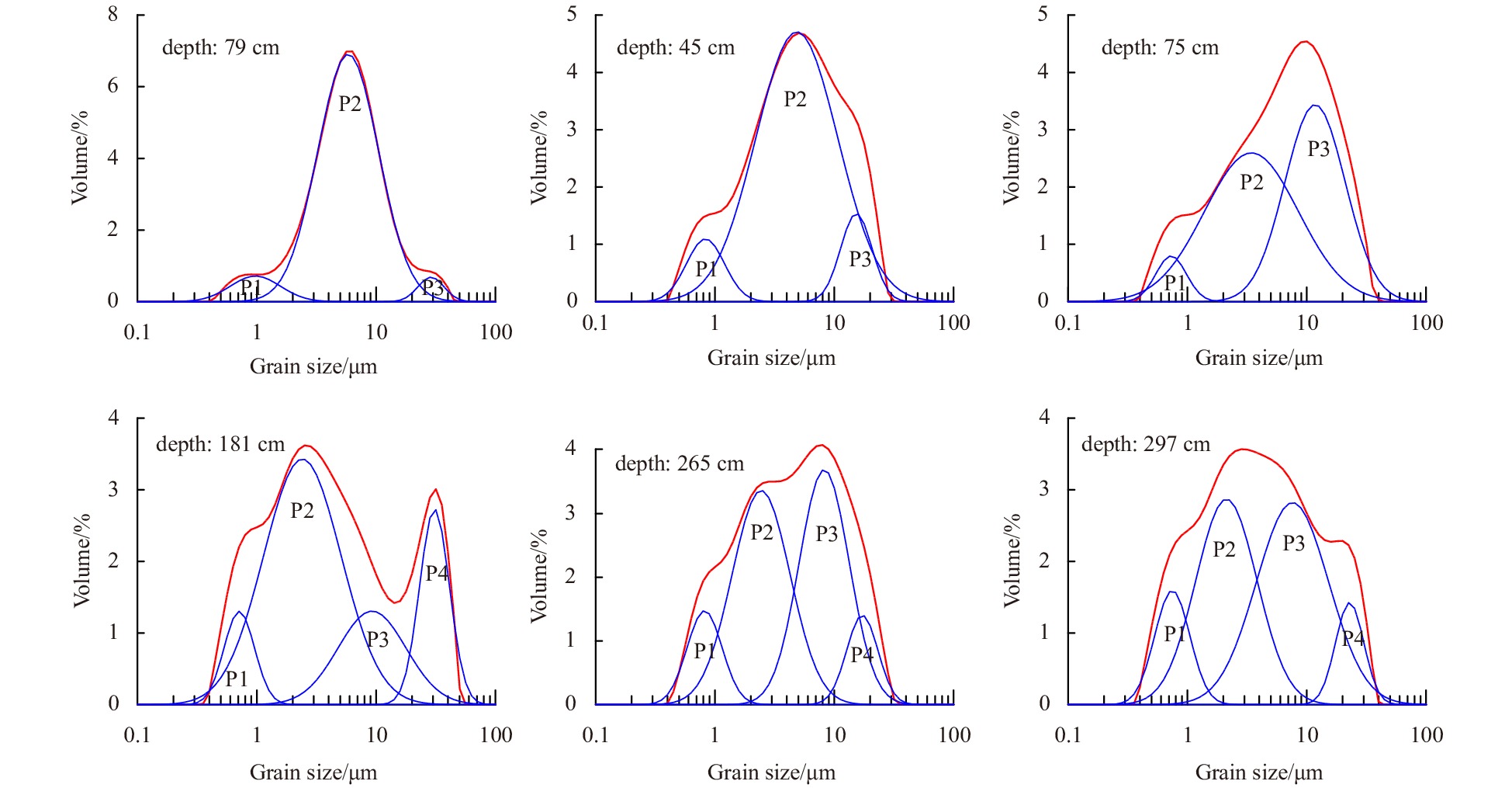
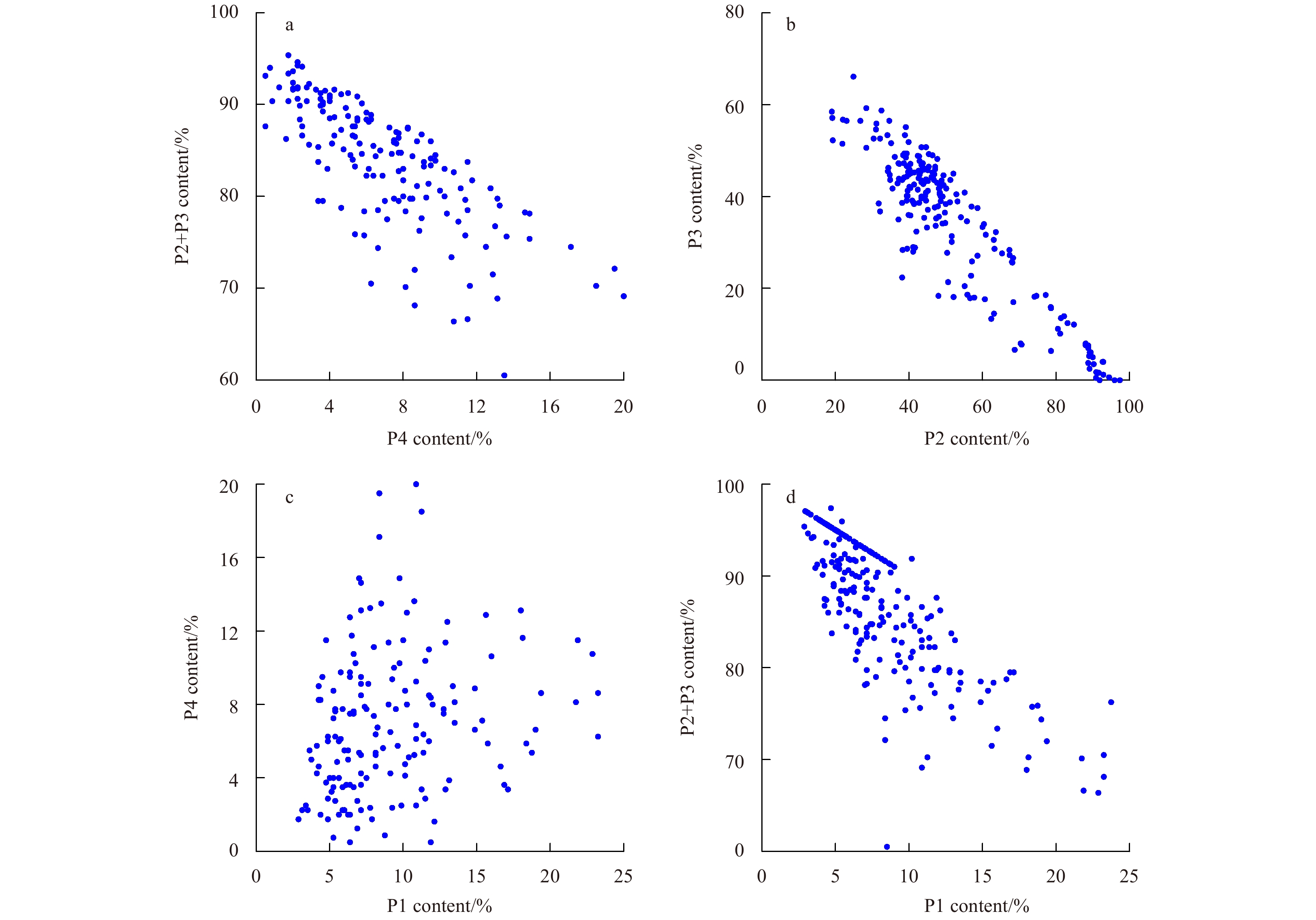
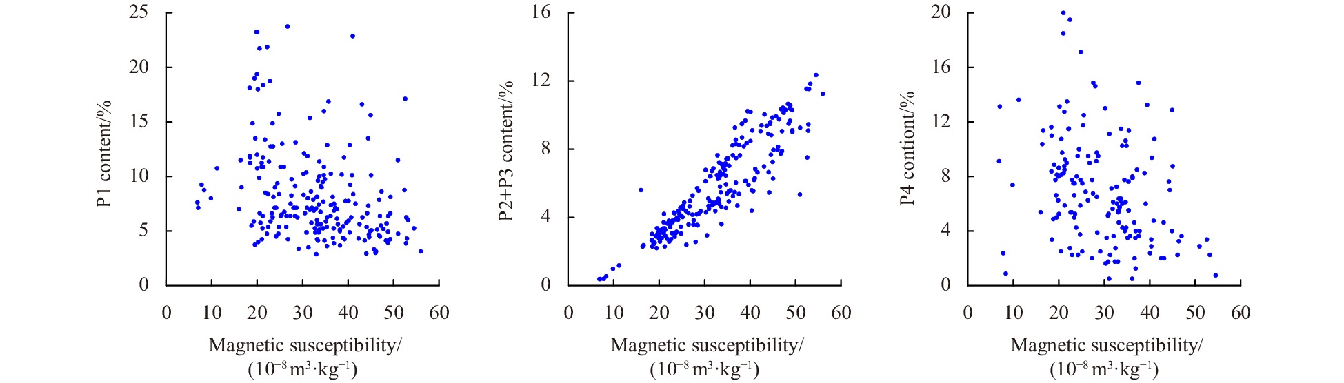
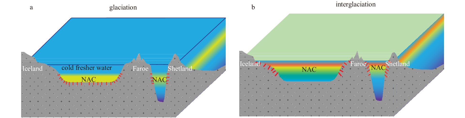
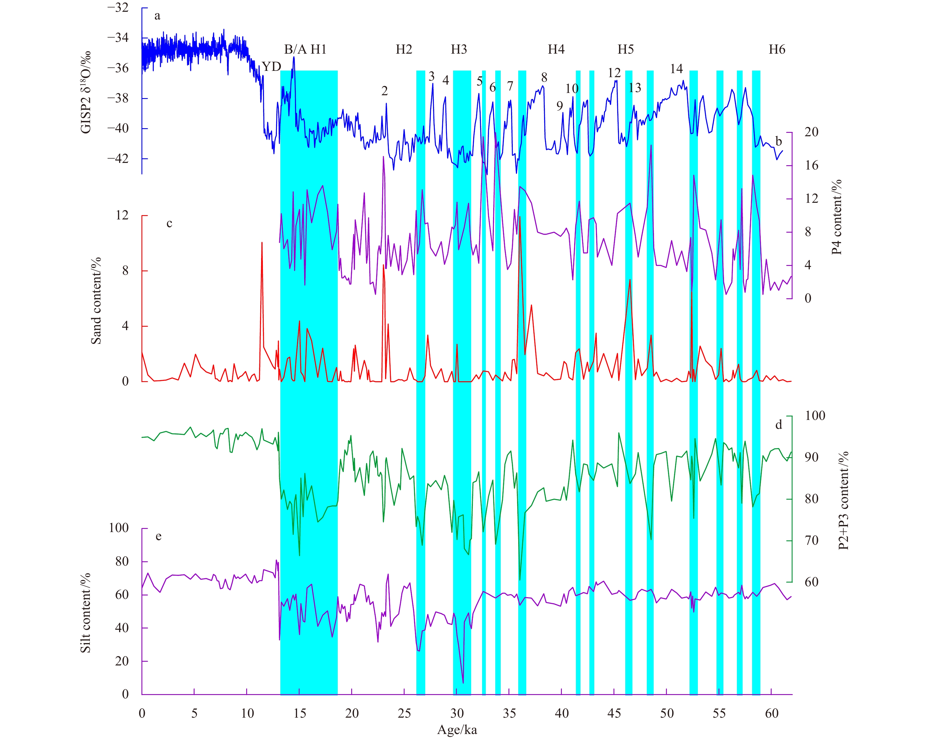
The grain size distribution of bulk sediment samples was decomposed in a core to reconstruct paleoceanographic evolution over the past 60 ka in the northern Norwegian Sea. The results show that sediments consisted of 3–4 grain populations derived from the North Atlantic Current (NAC) and Barents Ice Sheet (BIS). The grain size data suggest three palaeoceanographic evolution stages: (1) an environment affected by BIS and NAC and changed with the interstadial/stadial transition in phase with the Greenland ice-core record at 60–31 ka BP, during which discharge of icebergs and the content of the coarsest population containing ice-rafted debris (IRD) in the sediments increased significantly during stadial, while the fine silt population containing volcanic glasses increased with the enhancement of NAC during the interstadial; (2) an extreme environment controlled by BIS at 31–13 ka BP. BIS reached to its maximum at about 31 ka BP and the turbid plumes that formed at the leading edge of BIS contributed to a significant increase in the clayey population in sediments. Icebergs drained into the northern Norwegian Sea with periodical calving of the BIS at 31–19 ka BP. Subsequently, the ablation of the BIS discharged massive floods with clayey sediments and icebergs into the Norwegian Sea at 19–13 ka BP, resulting in a constant increase in clay and IRD in sediments; and (3) a marine environment similar to the present one under the strong influence of NAC following the complete melting of the BIS after 13 ka BP, NAC is the dominant transport agent and no IRD occurred in sediments. The fine silt populations containing volcanic glasses transported by NAC significantly increased.
The grain size distribution of bulk sediment samples was decomposed in a core to reconstruct paleoceanographic evolution over the past 60 ka in the northern Norwegian Sea. The results show that sediments consisted of 3–4 grain populations derived from the North Atlantic Current (NAC) and Barents Ice Sheet (BIS). The grain size data suggest three palaeoceanographic evolution stages: (1) an environment affected by BIS and NAC and changed with the interstadial/stadial transition in phase with the Greenland ice-core record at 60–31 ka BP, during which discharge of icebergs and the content of the coarsest population containing ice-rafted debris (IRD) in the sediments increased significantly during stadial, while the fine silt population containing volcanic glasses increased with the enhancement of NAC during the interstadial; (2) an extreme environment controlled by BIS at 31–13 ka BP. BIS reached to its maximum at about 31 ka BP and the turbid plumes that formed at the leading edge of BIS contributed to a significant increase in the clayey population in sediments. Icebergs drained into the northern Norwegian Sea with periodical calving of the BIS at 31–19 ka BP. Subsequently, the ablation of the BIS discharged massive floods with clayey sediments and icebergs into the Norwegian Sea at 19–13 ka BP, resulting in a constant increase in clay and IRD in sediments; and (3) a marine environment similar to the present one under the strong influence of NAC following the complete melting of the BIS after 13 ka BP, NAC is the dominant transport agent and no IRD occurred in sediments. The fine silt populations containing volcanic glasses transported by NAC significantly increased.


2021, 40(10): 118-128.
doi: 10.1007/s13131-021-1866-3
Abstract:
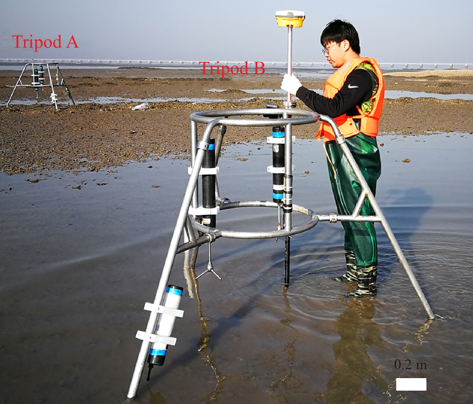
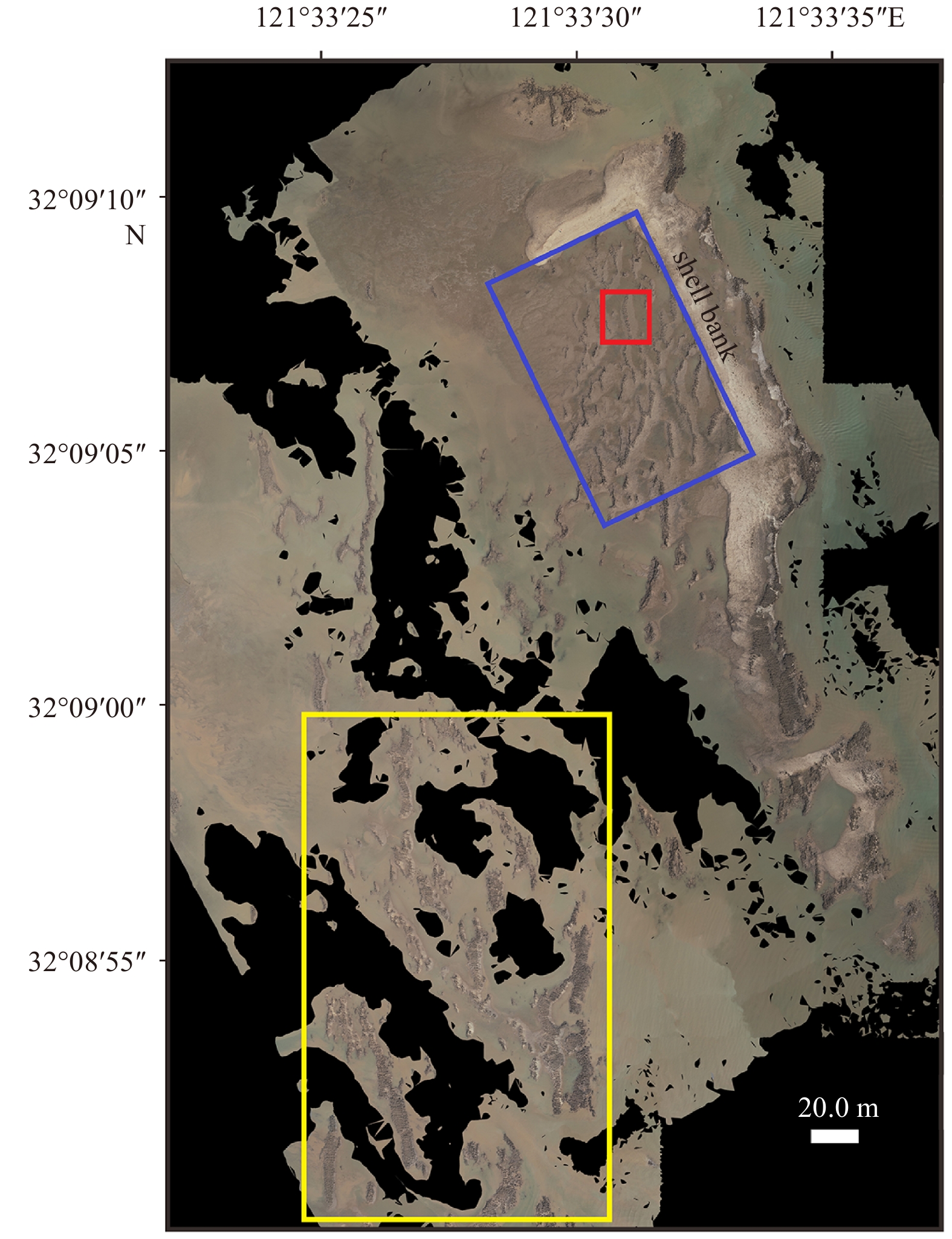
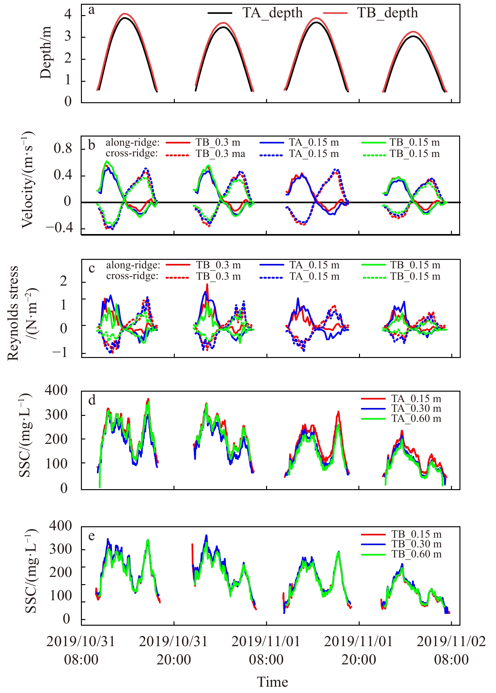
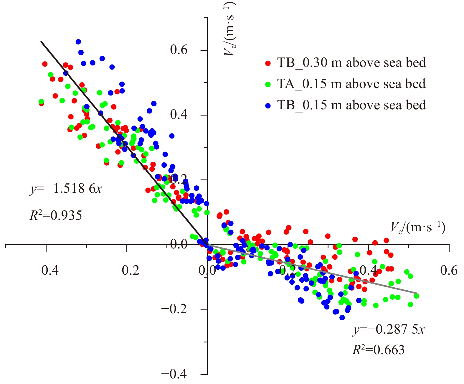
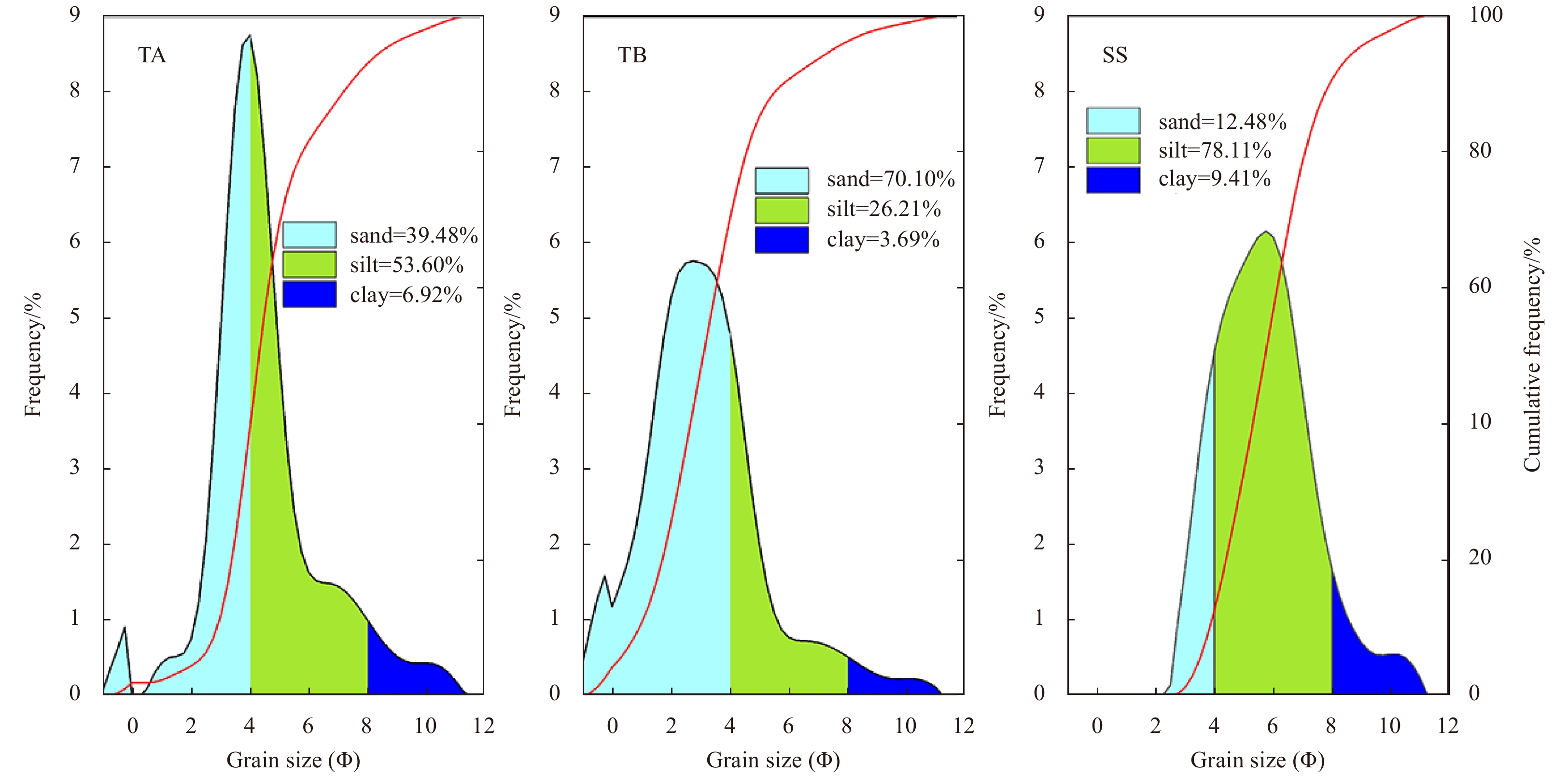
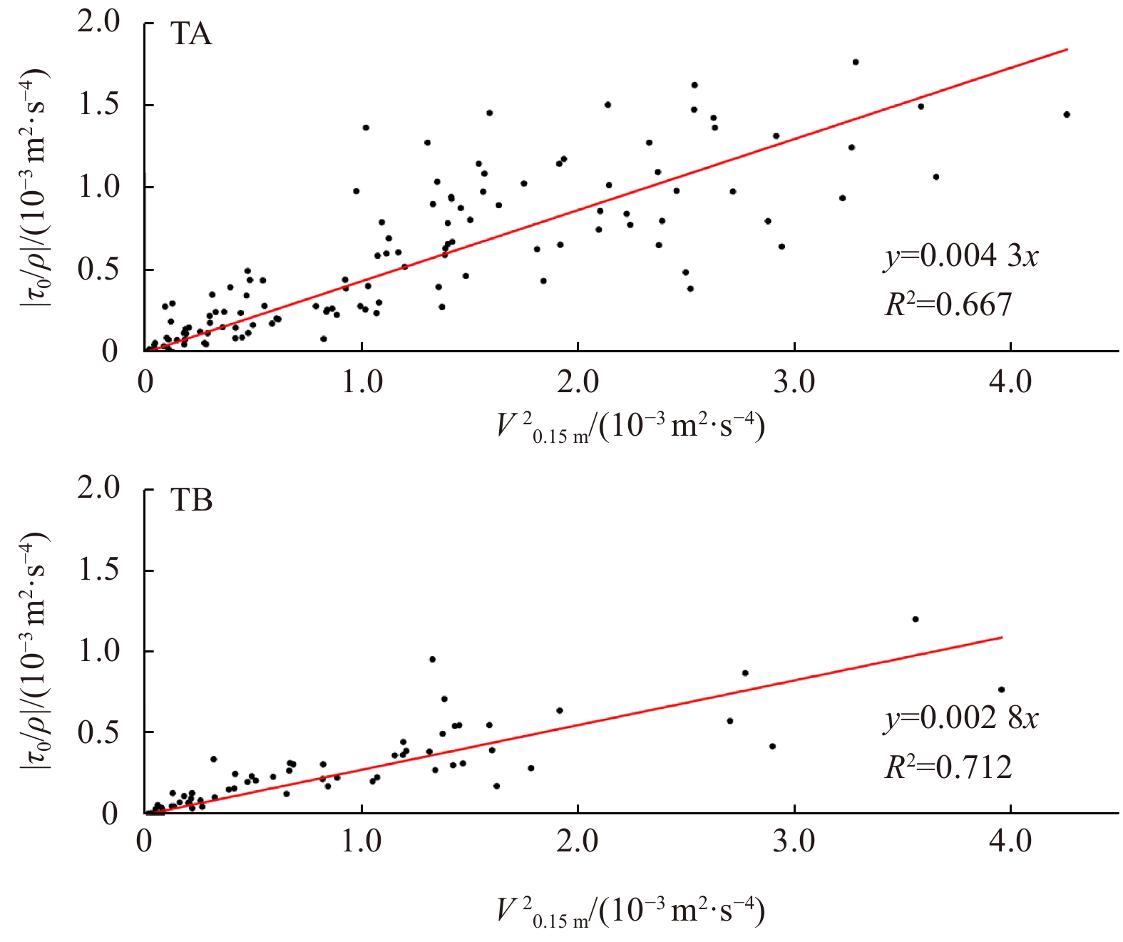
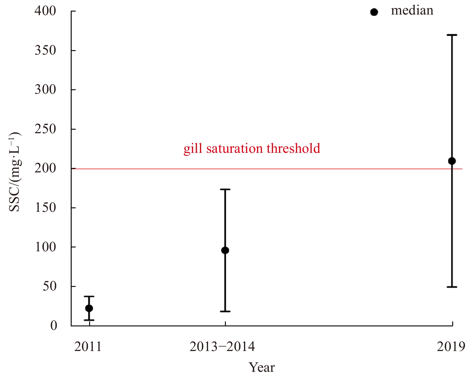
Oyster reefs and their spatial patterns are deemed to change the local hydrodynamic condition and exert profound impacts on the grain size, concentration and transportation of suspended sediments. Meanwhile, high suspended sediment concentration often results in excess mortality among oysters. Oyster reefs are rare and vital ecosystem in Liyashan national marine park, Jiangsu Coast, China. However, urgent conservation efforts should be made on account of the drastic reduction in reef areas. To investigate the sediment dynamics and the geomorphology, two tripod observation systems were deployed and UAV aerial surveys with elevation measurement using Real Time Kinematic (RTK) were also carried out. High mud content (60%) was found in the bed sediment at the reef ridge, causing much lower drag coefficient than other recorded values of living oyster reefs, indicating the death of oysters and the degradation of reefs in Liyashan. Ridgelines of the string reefs at 45° to the current direction and high suspended sediment concentration in the water body (50–370 mg/L) that exceeds the threshold (200 mg/L), which would affect nutrient uptake efficiency and further result in gill saturation, decrease of clearance rate and associated deposition, were probably crucial causes of the death of oysters. The findings are useful for restoring natural oyster reefs and designing artificial reefs for nature-based coastal defense.
Oyster reefs and their spatial patterns are deemed to change the local hydrodynamic condition and exert profound impacts on the grain size, concentration and transportation of suspended sediments. Meanwhile, high suspended sediment concentration often results in excess mortality among oysters. Oyster reefs are rare and vital ecosystem in Liyashan national marine park, Jiangsu Coast, China. However, urgent conservation efforts should be made on account of the drastic reduction in reef areas. To investigate the sediment dynamics and the geomorphology, two tripod observation systems were deployed and UAV aerial surveys with elevation measurement using Real Time Kinematic (RTK) were also carried out. High mud content (60%) was found in the bed sediment at the reef ridge, causing much lower drag coefficient than other recorded values of living oyster reefs, indicating the death of oysters and the degradation of reefs in Liyashan. Ridgelines of the string reefs at 45° to the current direction and high suspended sediment concentration in the water body (50–370 mg/L) that exceeds the threshold (200 mg/L), which would affect nutrient uptake efficiency and further result in gill saturation, decrease of clearance rate and associated deposition, were probably crucial causes of the death of oysters. The findings are useful for restoring natural oyster reefs and designing artificial reefs for nature-based coastal defense.


2021, 40(10): 129-143.
doi: 10.1007/s13131-021-1836-9
Abstract:
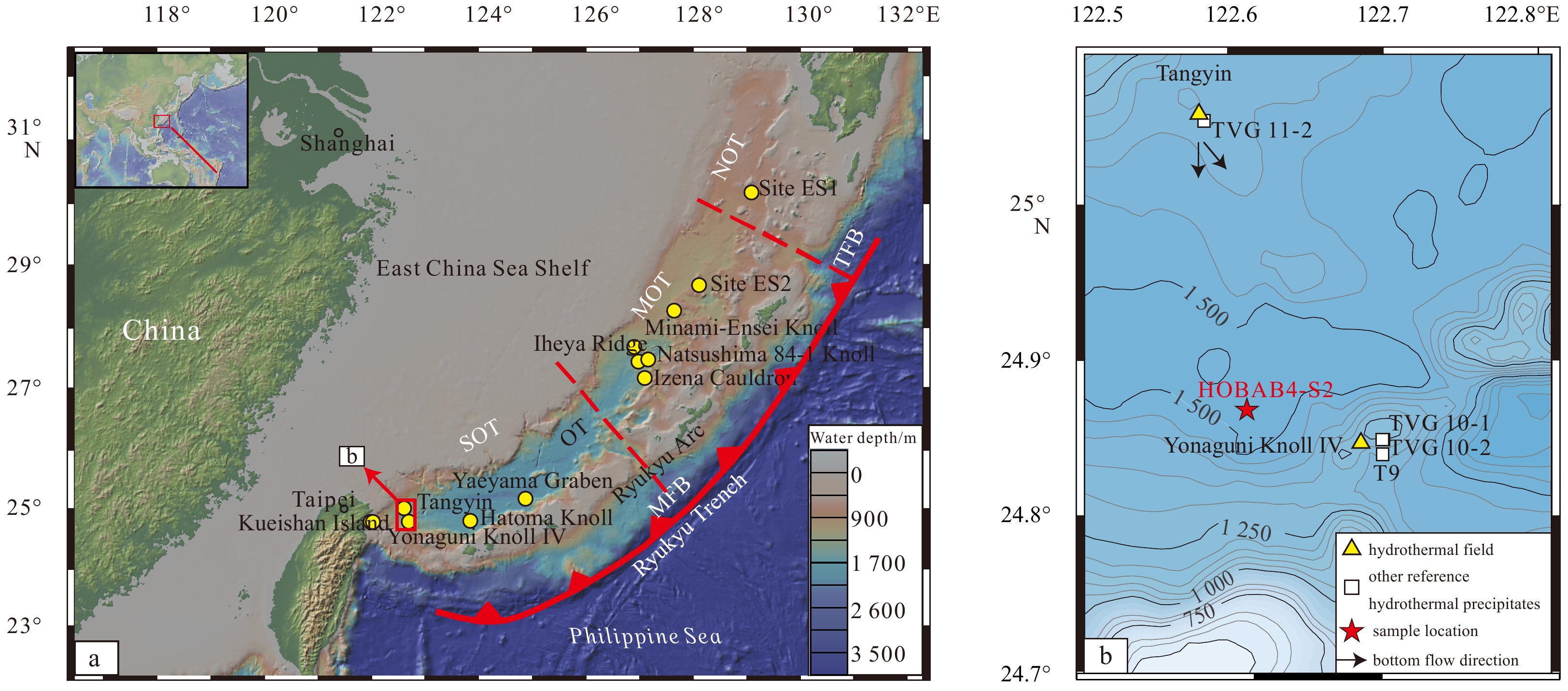
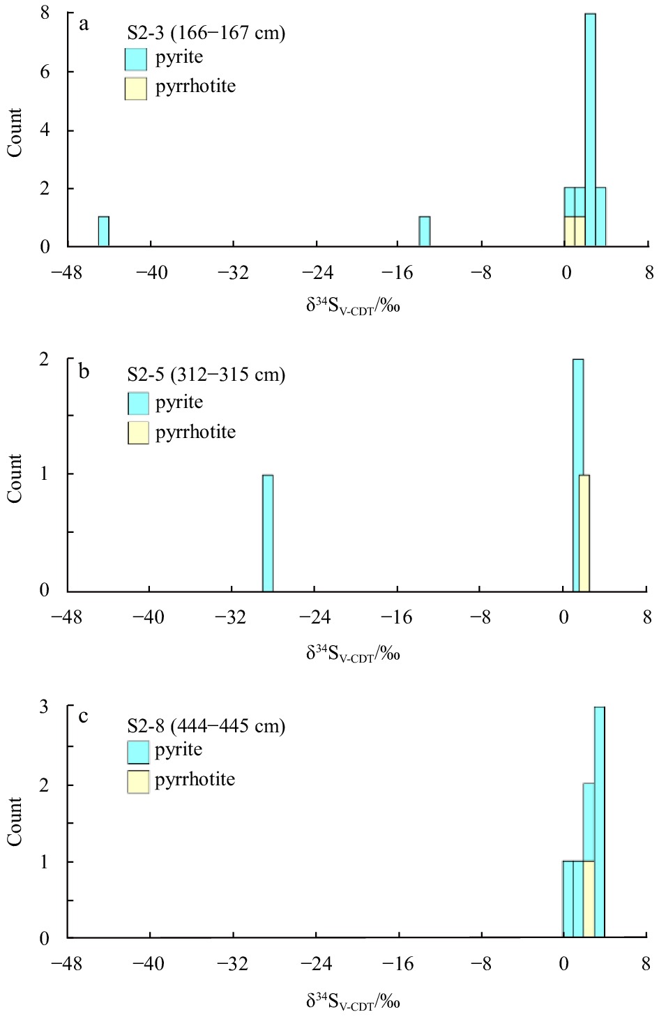
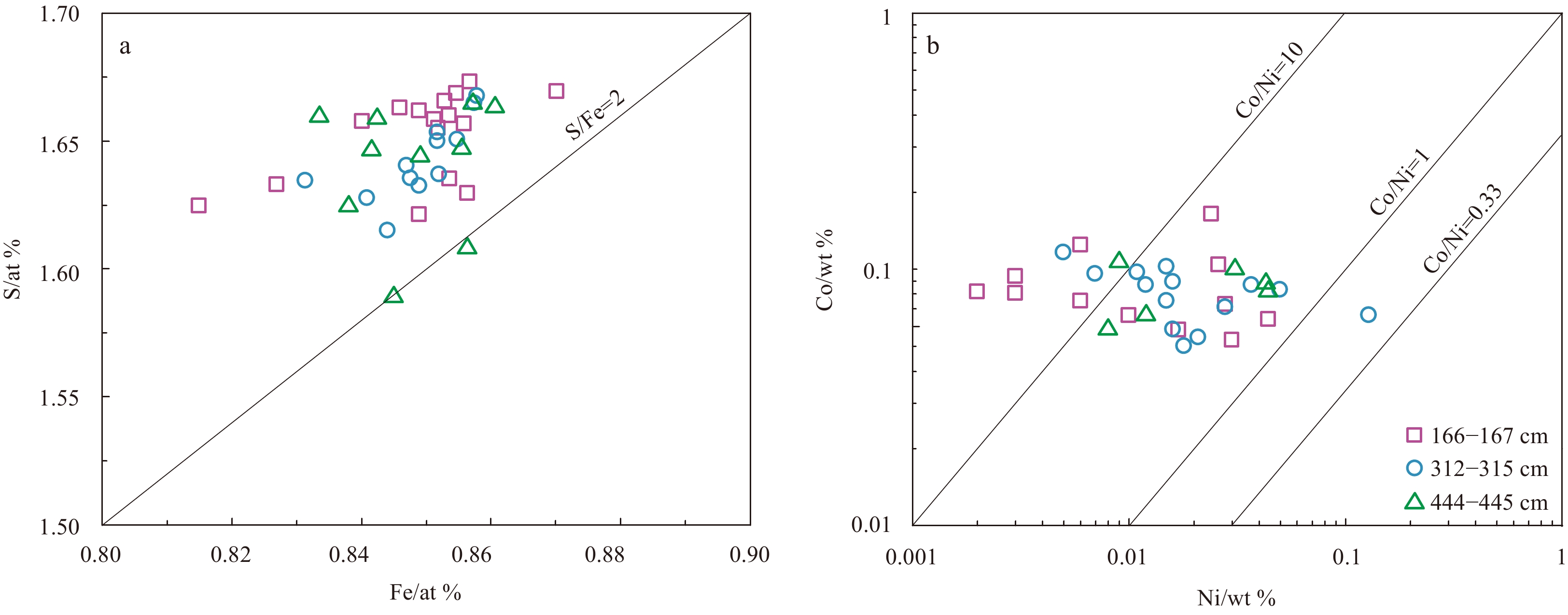
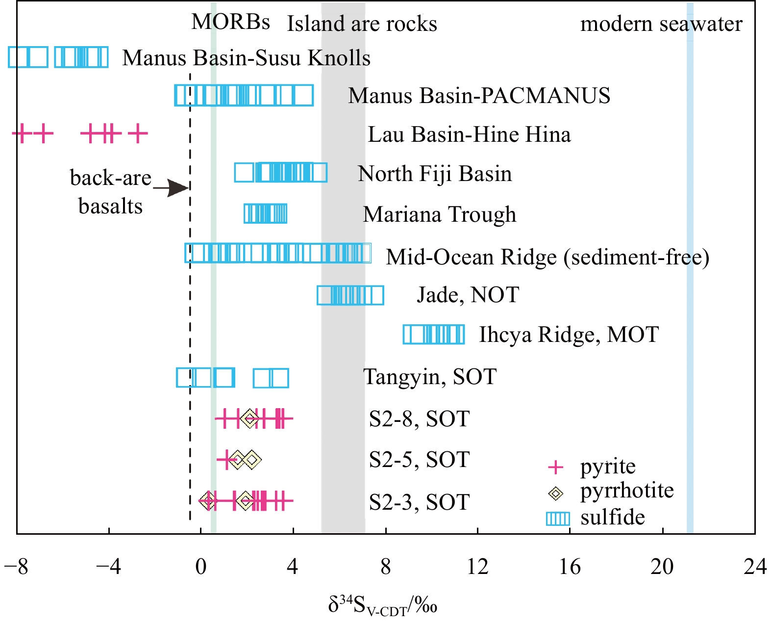
Studies of the mineralogy and sulfur isotope composition of sediment-hosted hydrothermal sulfide minerals in cores are important for understanding the seafloor mineralization environment and material source and reconstructing the hydrothermal history. However, the source of ore-forming materials and the history of hydrothermal activity in the southern Okinawa Trough (SOT) remain unclear. Here, the mineralogy and sulfur isotope characteristics of sulfides from gravity core HOBAB4-S2, collected between the Yonaguni Knoll IV hydrothermal field (HF) and the Tangyin HF, was investigated. Enrichments in Zn (up to 321×10−6), Cu (up to 73.7×10⁻⁶), and Pb (up to 160×10−6) and the presence of pyrite, galena, pyrrhotite and minor sphalerite and chalcopyrite provide evidence for the input of hydrothermal materials into the sediments. The pyrite morphologies include disseminated cubic, pentagonal dodecahedron, and framboidal forms. Except for minor framboidal pyrite, euhedral pyrite from core HOBAB4-S2 is mainly of hydrothermal origin with Co/Ni ratios >1 and S/Fe atomic ratios <2 in the Cu-Zn-Pb-rich layers. The occurrences of hexagonal pyrrhotite, high-Co (up to 0.17%) pyrite and high-Fe sphalerite indicate that the hydrothermal precipitates formed at medium-high temperatures and low-sulfur fugacity (fS2) environments. The δ34S values of sulfides (0.21‰–3.45‰) with low- fS2 mineral assemblages (e.g., pyrrhotite ± high-Fe sphalerite) in the core are significantly lower than those of magmatic rocks and seawater, indicating possible incorporation of previously formed biogenic sulfur in the sediment. Combined with the age model of the core, it is suggested that hydrothermal activity likely began in the Tangyin HF before AD 1445–1483 and that at least three active episodes may have occurred since then.
Studies of the mineralogy and sulfur isotope composition of sediment-hosted hydrothermal sulfide minerals in cores are important for understanding the seafloor mineralization environment and material source and reconstructing the hydrothermal history. However, the source of ore-forming materials and the history of hydrothermal activity in the southern Okinawa Trough (SOT) remain unclear. Here, the mineralogy and sulfur isotope characteristics of sulfides from gravity core HOBAB4-S2, collected between the Yonaguni Knoll IV hydrothermal field (HF) and the Tangyin HF, was investigated. Enrichments in Zn (up to 321×10−6), Cu (up to 73.7×10⁻⁶), and Pb (up to 160×10−6) and the presence of pyrite, galena, pyrrhotite and minor sphalerite and chalcopyrite provide evidence for the input of hydrothermal materials into the sediments. The pyrite morphologies include disseminated cubic, pentagonal dodecahedron, and framboidal forms. Except for minor framboidal pyrite, euhedral pyrite from core HOBAB4-S2 is mainly of hydrothermal origin with Co/Ni ratios >1 and S/Fe atomic ratios <2 in the Cu-Zn-Pb-rich layers. The occurrences of hexagonal pyrrhotite, high-Co (up to 0.17%) pyrite and high-Fe sphalerite indicate that the hydrothermal precipitates formed at medium-high temperatures and low-sulfur fugacity (fS2) environments. The δ34S values of sulfides (0.21‰–3.45‰) with low- fS2 mineral assemblages (e.g., pyrrhotite ± high-Fe sphalerite) in the core are significantly lower than those of magmatic rocks and seawater, indicating possible incorporation of previously formed biogenic sulfur in the sediment. Combined with the age model of the core, it is suggested that hydrothermal activity likely began in the Tangyin HF before AD 1445–1483 and that at least three active episodes may have occurred since then.


2021, 40(10): 144-151.
doi: 10.1007/s13131-021-1834-y
Abstract:
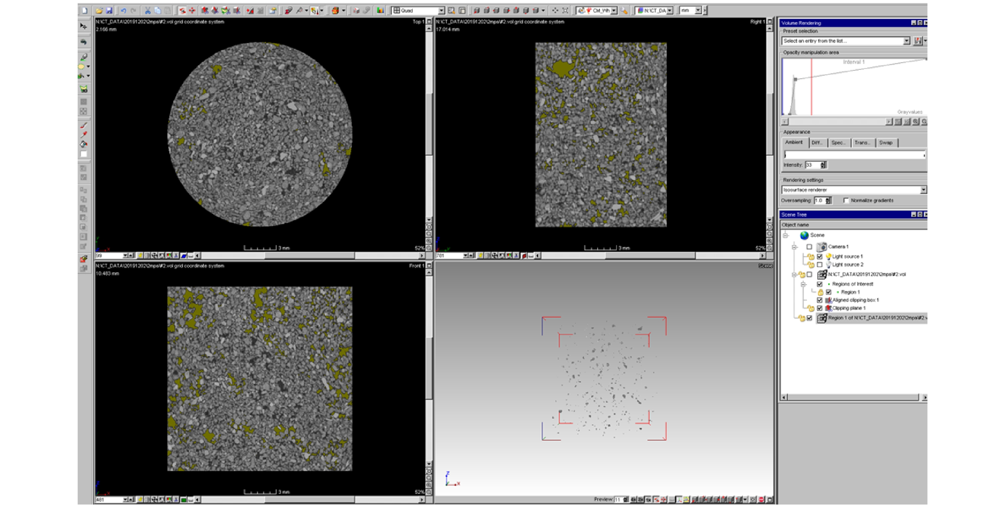
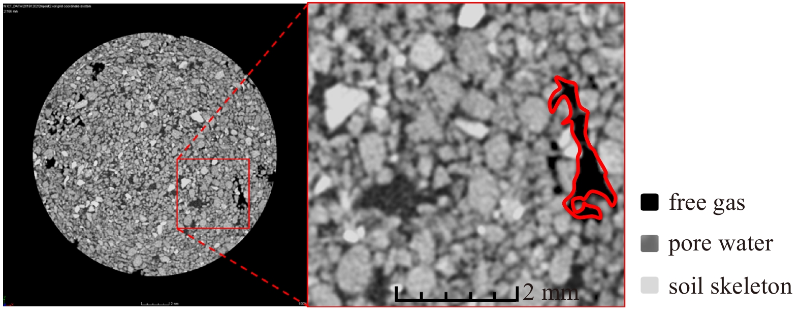
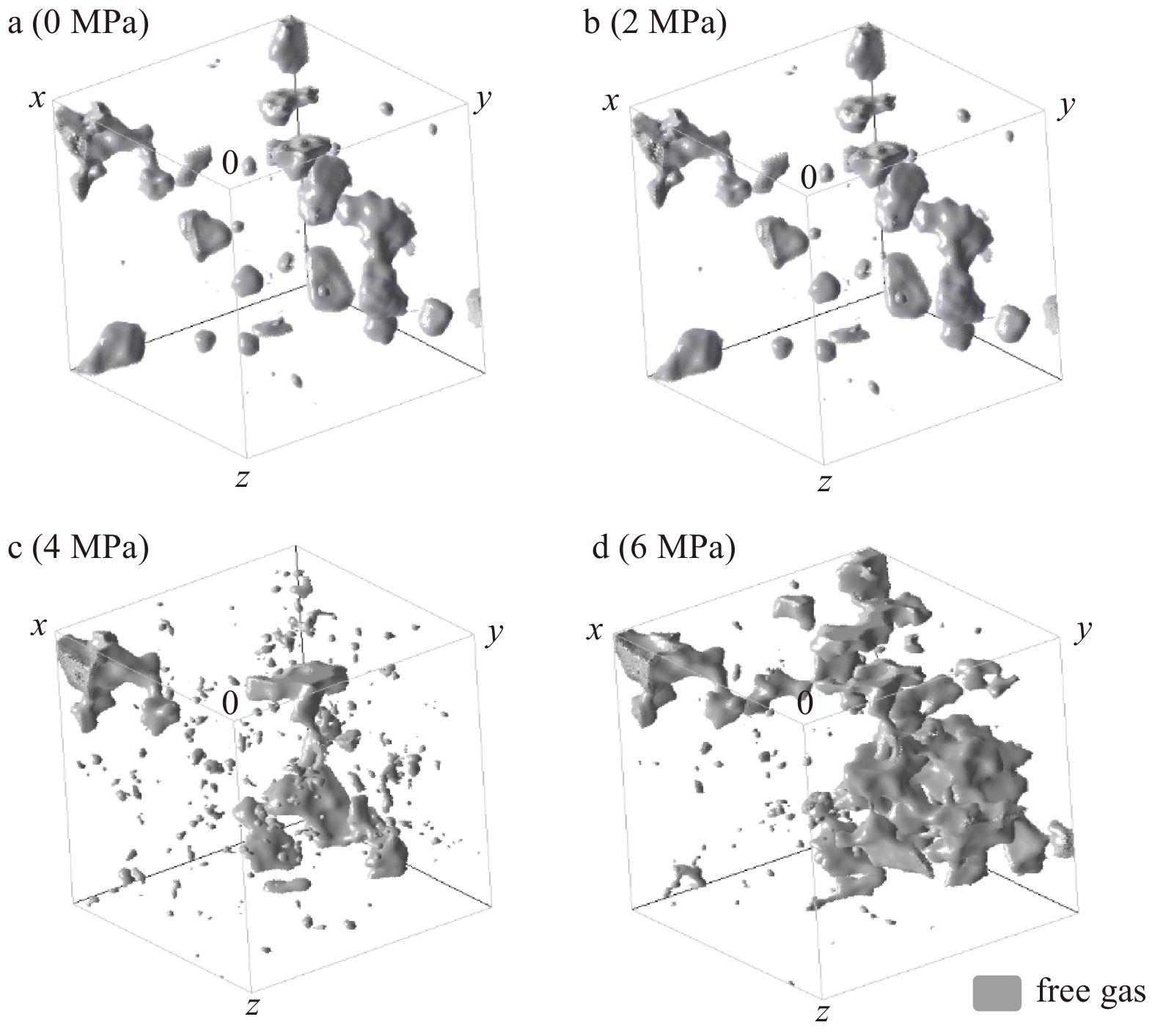
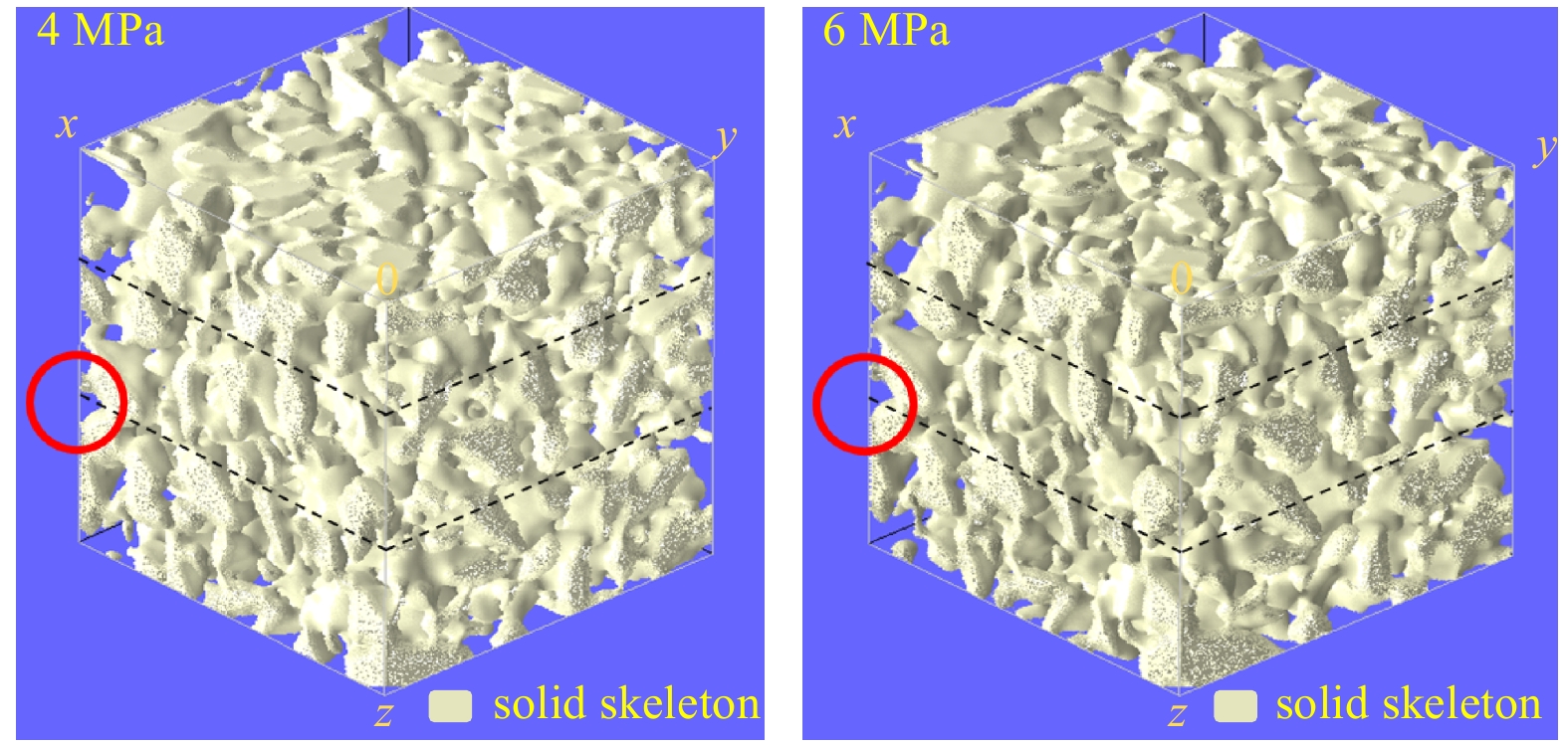
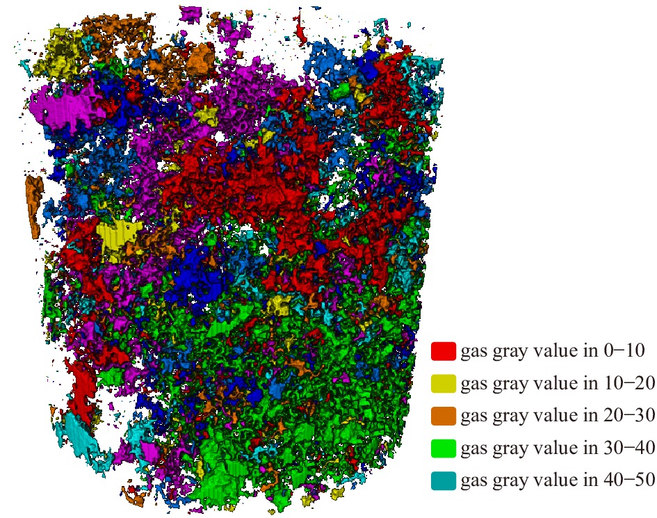
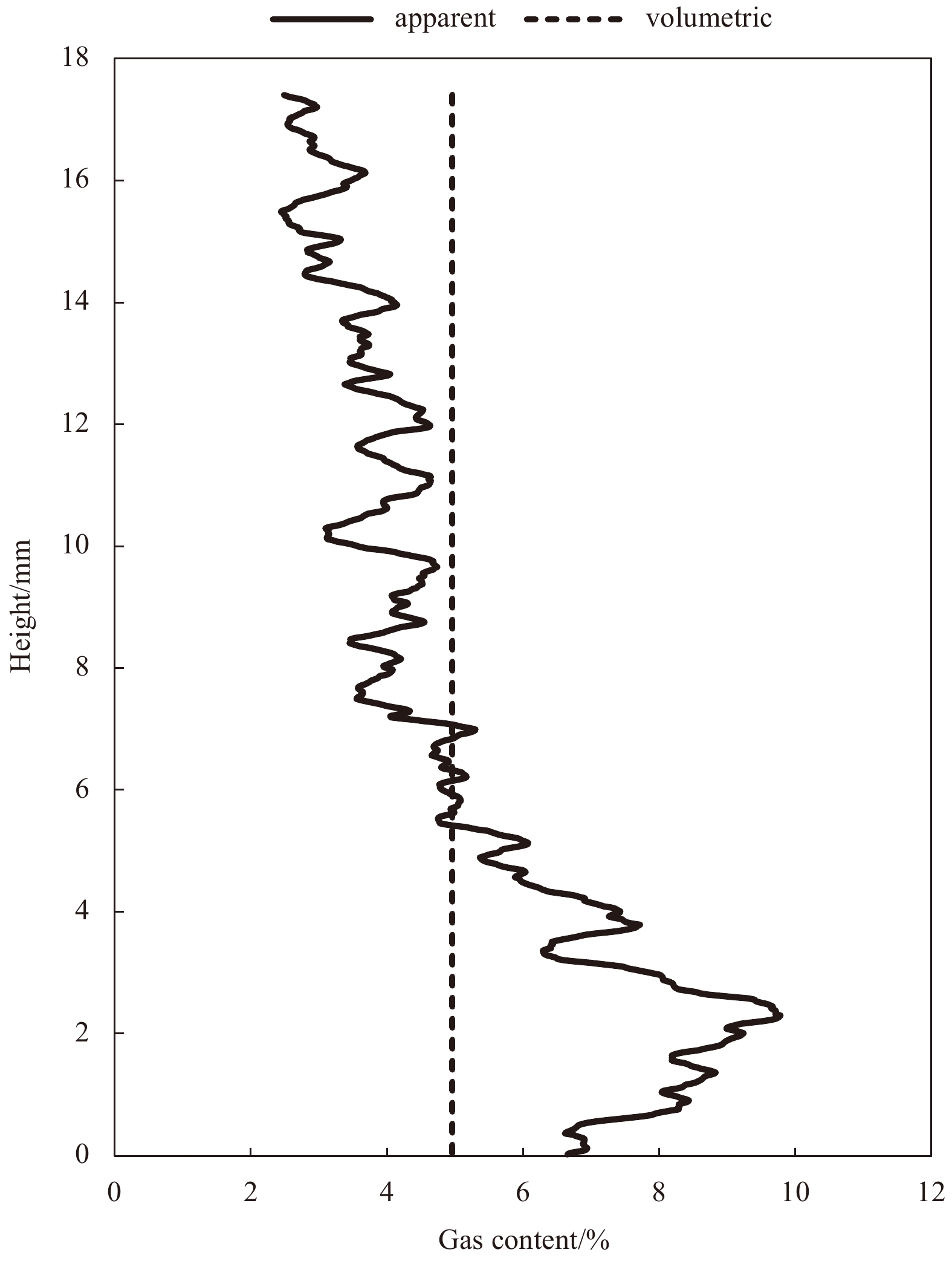
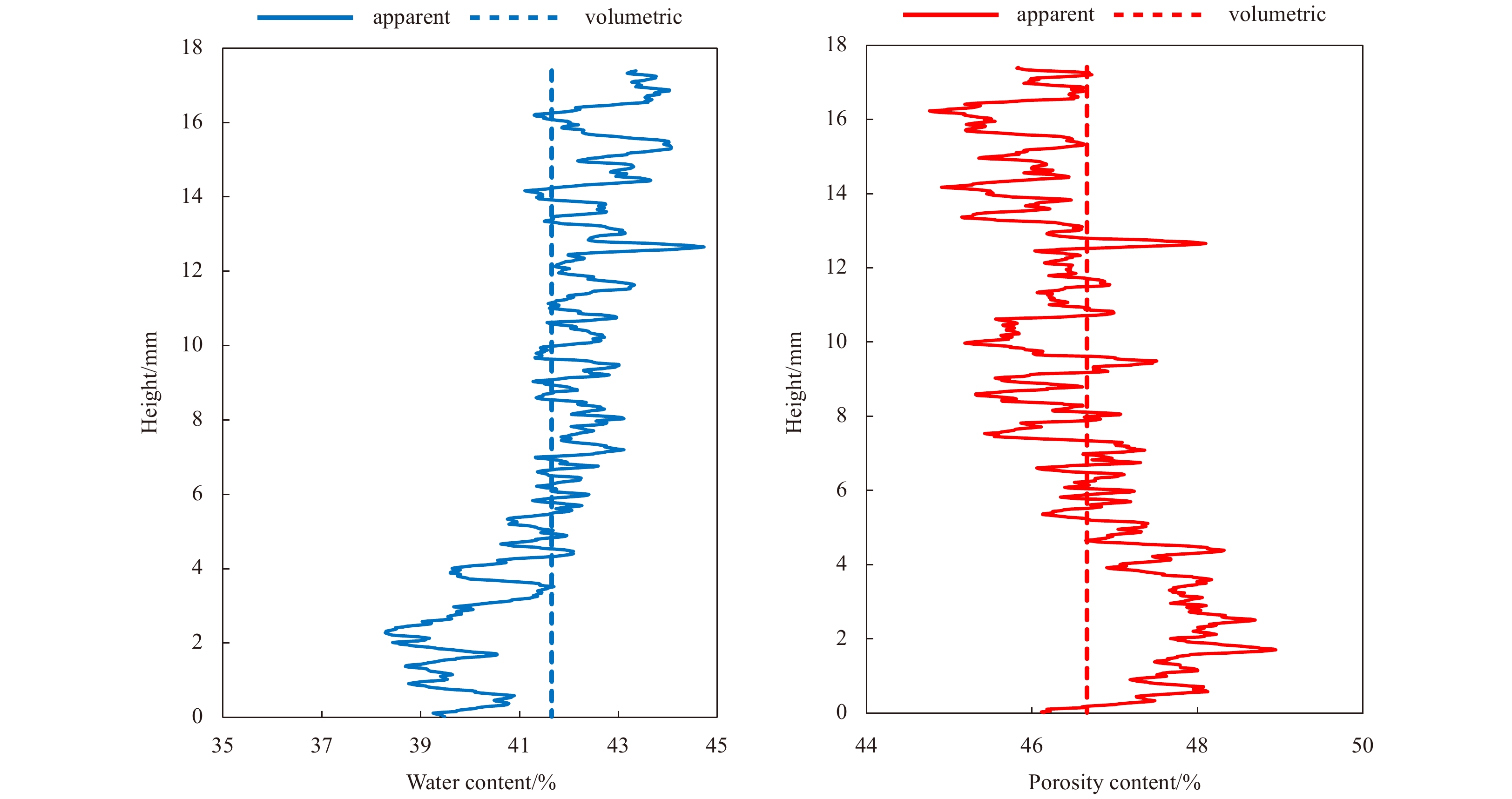
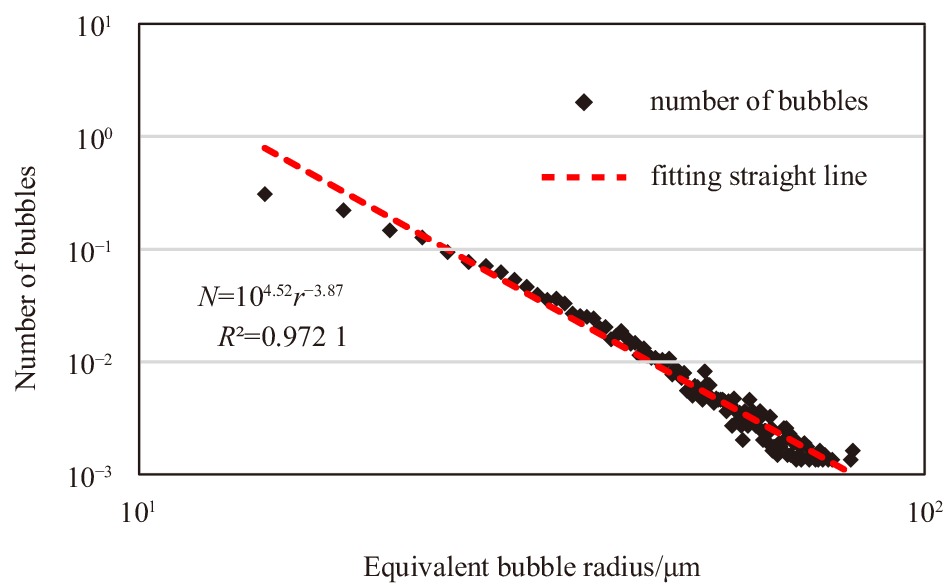
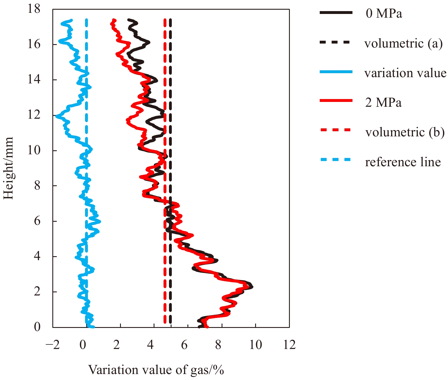
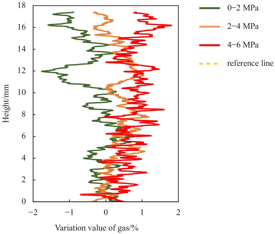
Gas-bearing sediments are widely distributed in five continents all over the world. Most of the gases exist in the soil skeleton in the form of discrete large bubbles. The existence of gas-phase may increase or decrease the strength of the soil skeleton. So far, bubbles’ structural morphology and evolution characteristics in soil skeleton lack research, and the influence of different gas reservoir pressures on bubbles are still unclear. The micro characteristics of bubbles in the same sediment sample were studied using an industrial CT scanning test system to solve these problems. Using the image processing software, the micro variation characteristics of gas-bearing sediments in gas reservoir pressure change are obtained. The results show that the number and volume of bubbles in different equivalent radius ranges will change regularly under different gas reservoir pressure. With the increase of gas reservoir pressure, the number and volume of tiny bubbles decrease. In contrast, the number and volume of large bubbles increase, and the gas content in different positions increases and occupies a dominant position, driving the reduction of pore water and soil skeleton movement.
Gas-bearing sediments are widely distributed in five continents all over the world. Most of the gases exist in the soil skeleton in the form of discrete large bubbles. The existence of gas-phase may increase or decrease the strength of the soil skeleton. So far, bubbles’ structural morphology and evolution characteristics in soil skeleton lack research, and the influence of different gas reservoir pressures on bubbles are still unclear. The micro characteristics of bubbles in the same sediment sample were studied using an industrial CT scanning test system to solve these problems. Using the image processing software, the micro variation characteristics of gas-bearing sediments in gas reservoir pressure change are obtained. The results show that the number and volume of bubbles in different equivalent radius ranges will change regularly under different gas reservoir pressure. With the increase of gas reservoir pressure, the number and volume of tiny bubbles decrease. In contrast, the number and volume of large bubbles increase, and the gas content in different positions increases and occupies a dominant position, driving the reduction of pore water and soil skeleton movement.


2021, 40(10): 152-166.
doi: 10.1007/s13131-021-1761-y
Abstract:
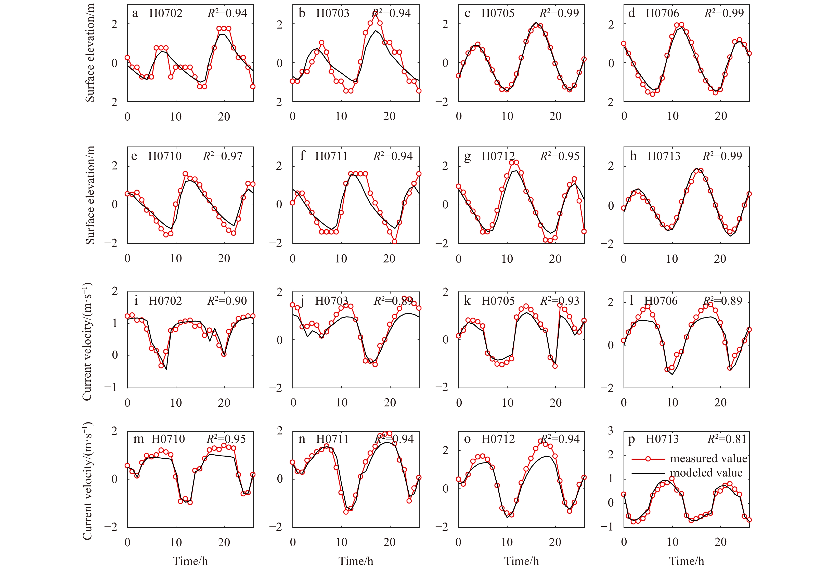
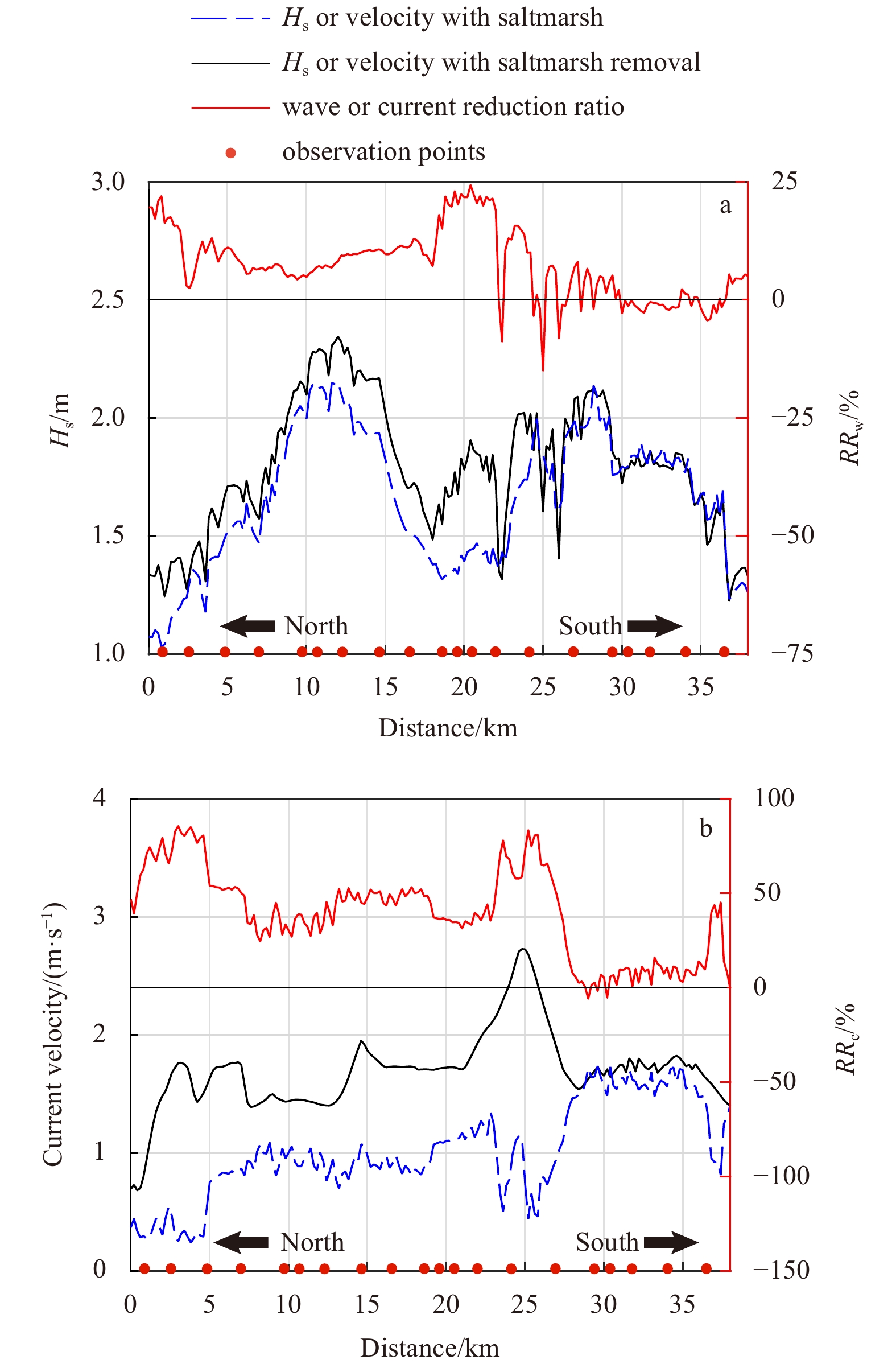
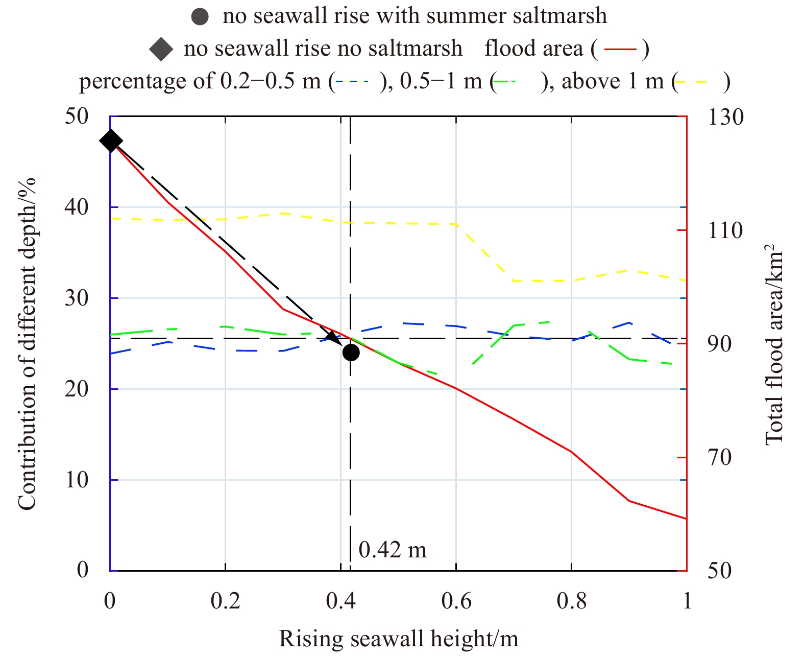
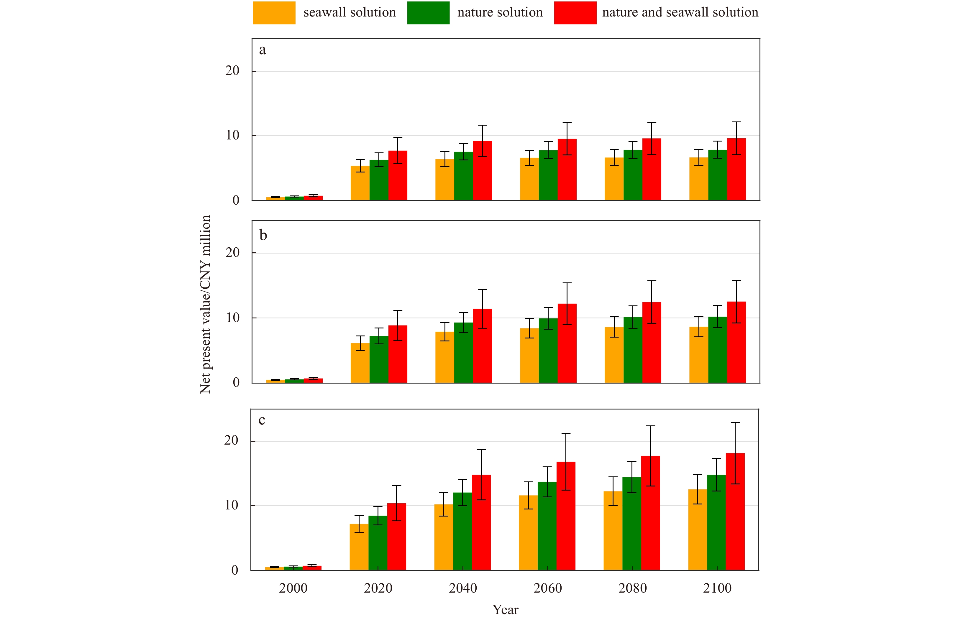
With climate change and rising sea levels, the coastal zone’s flood risk is deteriorating. Previous researches have shown a gradually degrading capacity of traditional hard engineering structures (e.g., seawall, dikes) on flood mitigation due to problems such as land subsidence and insufficient maintenance. To remedy the defects, the “building with nature concept” for coastal protection with saltmarshes was examined by combining field measurements and numerical simulations. The advantages of saltmarsh over traditional seawall on flood protection was demonstrated from the perspective of both flood area mitigation and economic gain, based on scenario simulations. Results show that tidal wetlands are essential in mitigating significant wave heights (Hs) and current velocities even during storm conditions. The storm wave and current velocity reduction ratio (\begin{document}$R{R}_{{\rm{w}}}$\end{document} ![]()
![]()
\begin{document}$R{R}_{{\rm{c}}}$\end{document} ![]()
![]()
With climate change and rising sea levels, the coastal zone’s flood risk is deteriorating. Previous researches have shown a gradually degrading capacity of traditional hard engineering structures (e.g., seawall, dikes) on flood mitigation due to problems such as land subsidence and insufficient maintenance. To remedy the defects, the “building with nature concept” for coastal protection with saltmarshes was examined by combining field measurements and numerical simulations. The advantages of saltmarsh over traditional seawall on flood protection was demonstrated from the perspective of both flood area mitigation and economic gain, based on scenario simulations. Results show that tidal wetlands are essential in mitigating significant wave heights (Hs) and current velocities even during storm conditions. The storm wave and current velocity reduction ratio (


2021, 40(10): 167-175.
doi: 10.1007/s13131-021-1816-0
Abstract:
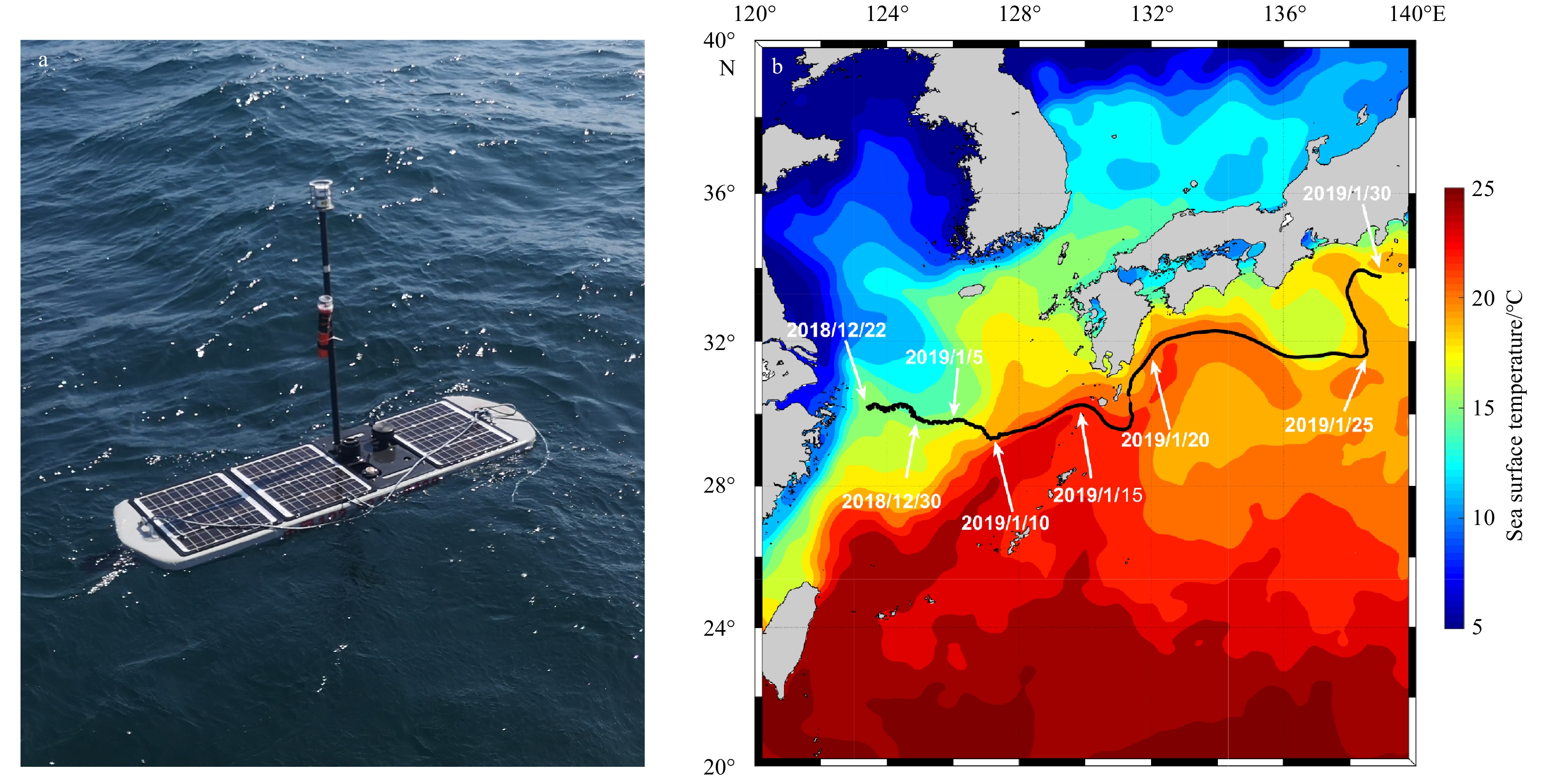
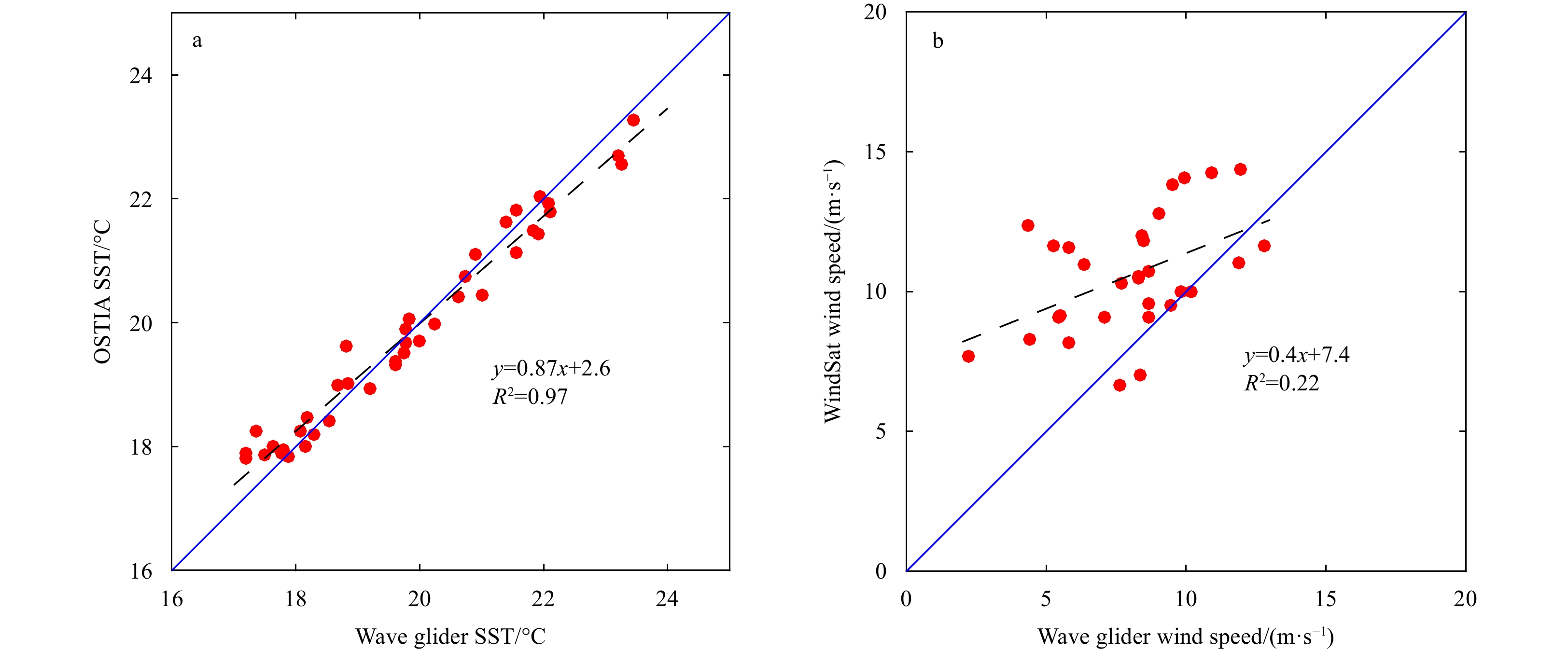
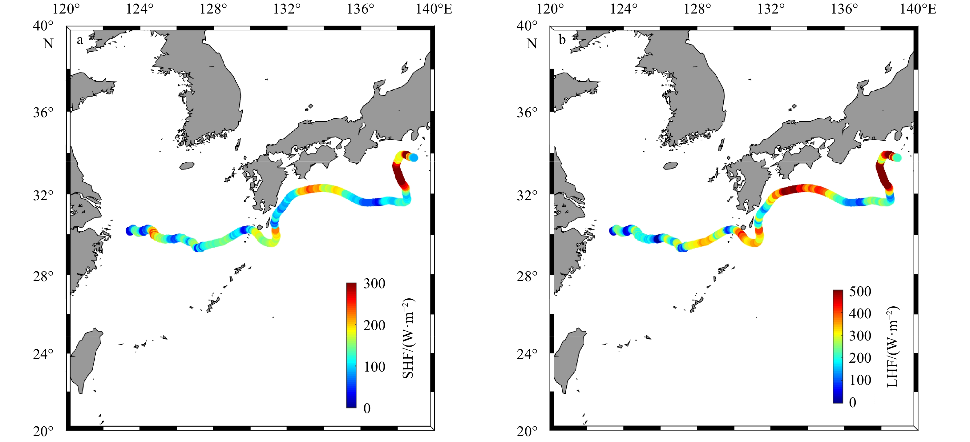
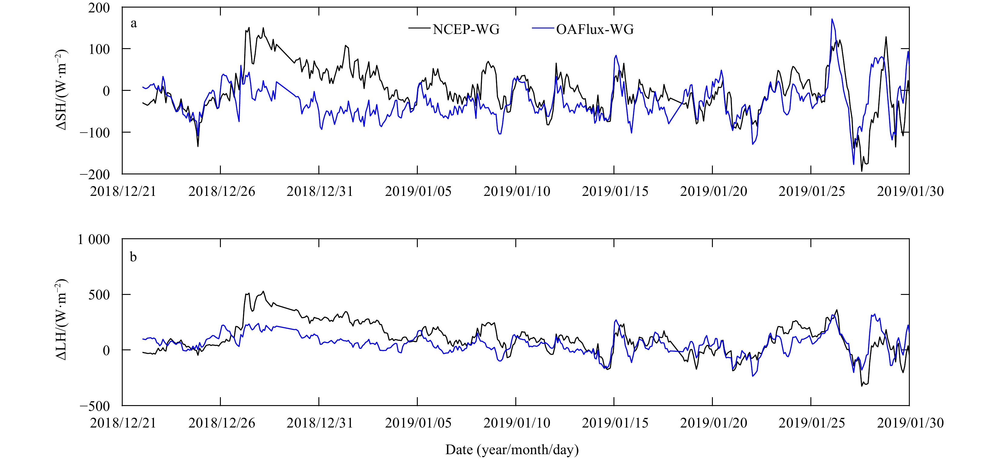
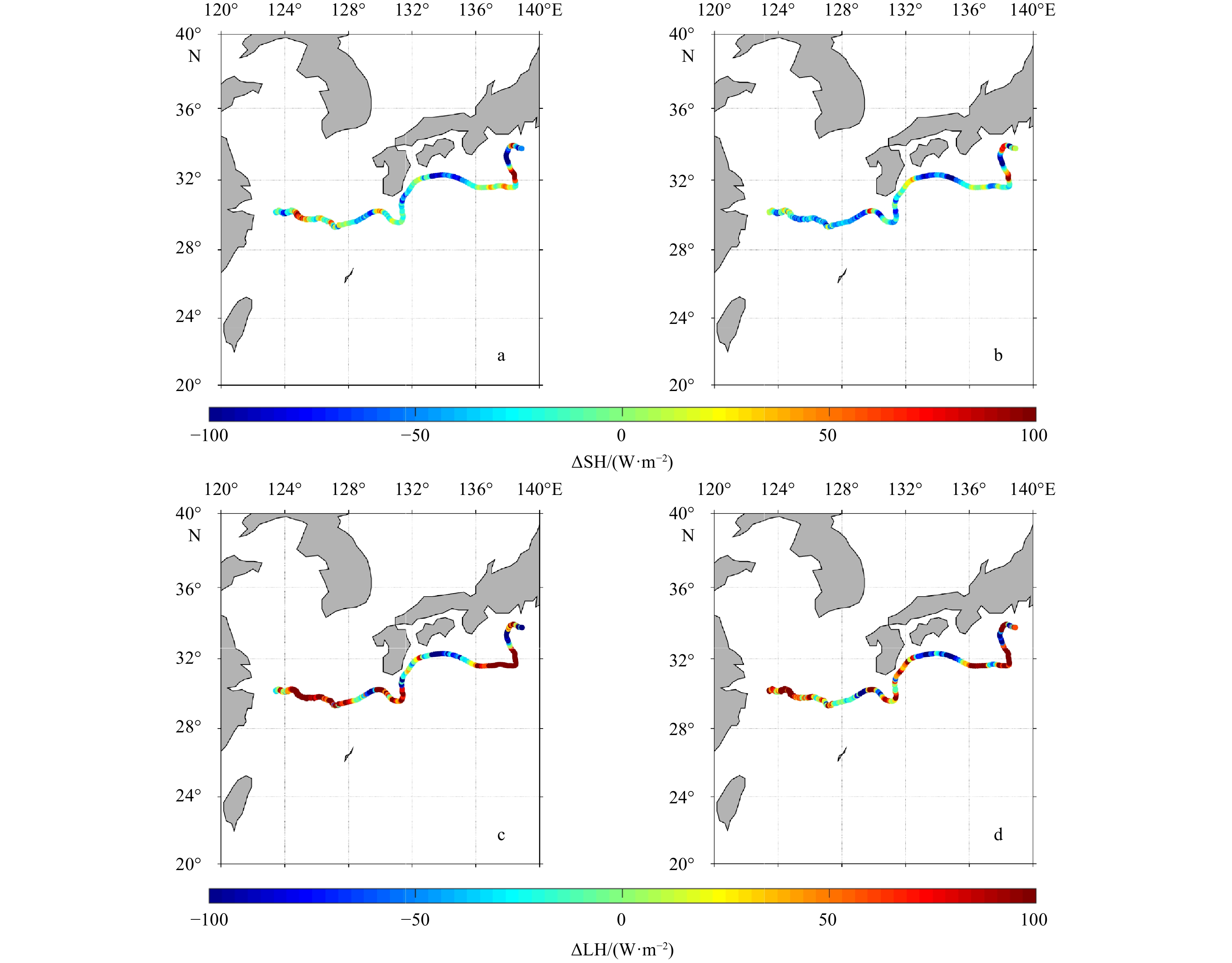
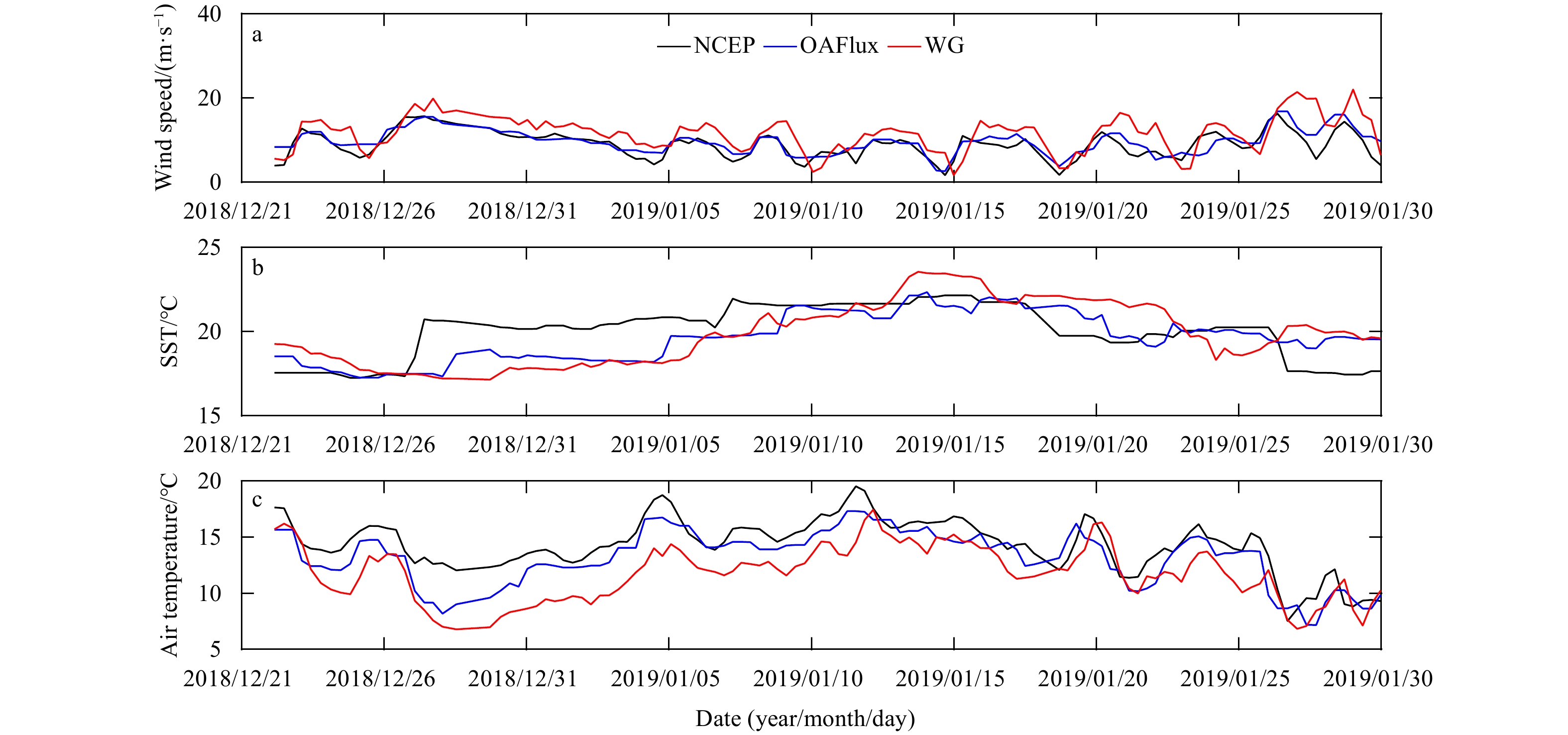
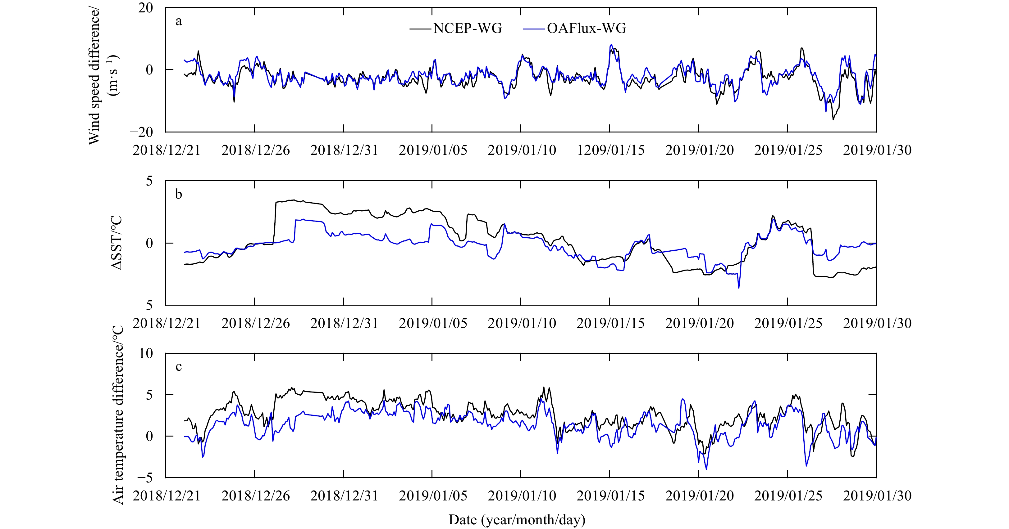
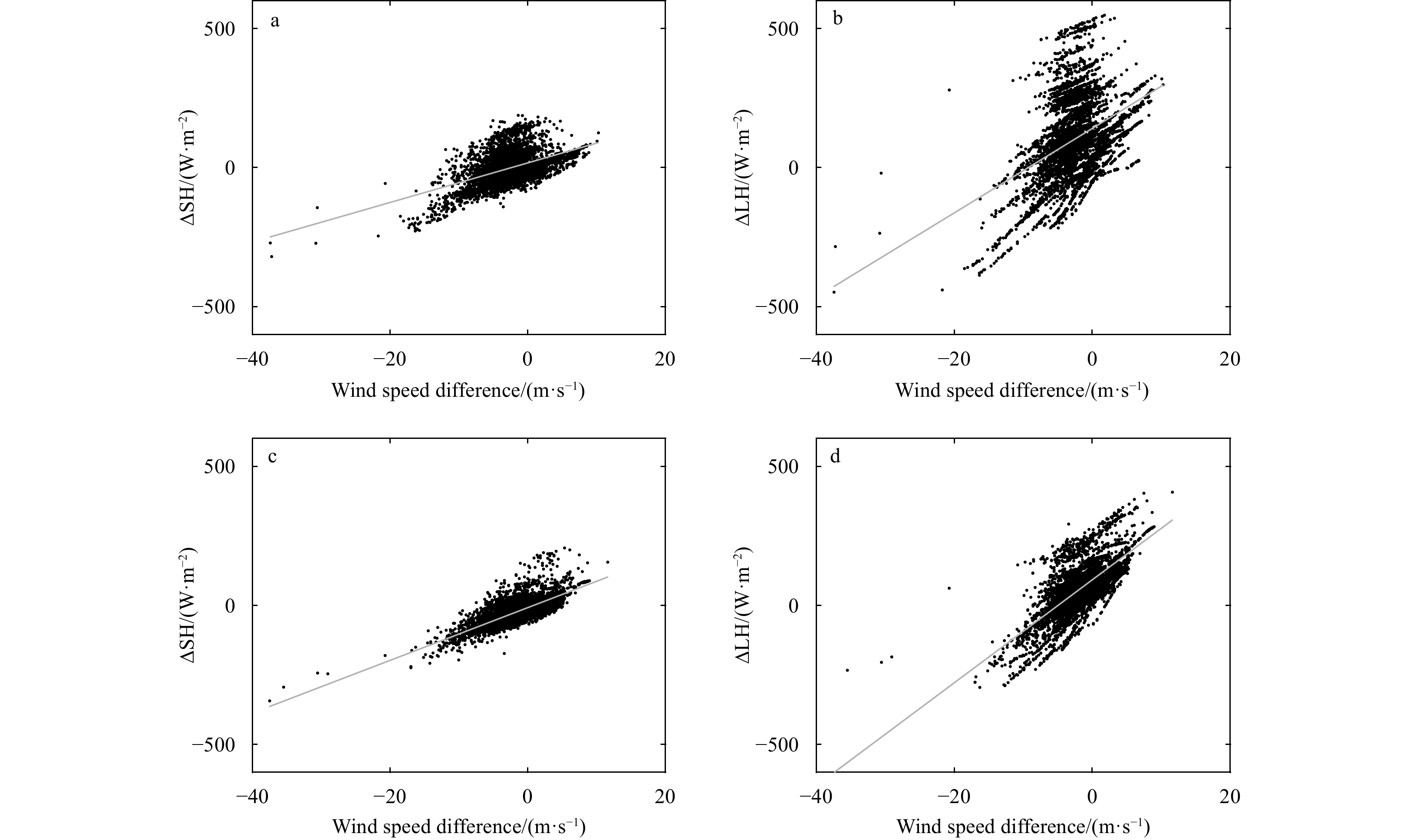
Latent and sensible heat fluxes based on observations from a Black Pearl wave glider were estimated along the main stream of the Kuroshio Current from the East China Sea to the east coast of Japan, from December 2018 to January 2019. It is found that the data obtained by the wave glider were comparable to the sea surface temperature data from the Operational Sea Surface Temperature and Sea Ice Analysis and the wind field data from WindSat. The Coupled Ocean Atmosphere Response Experiment 3.0 (COARE 3.0) algorithm was used to calculate the change in air-sea turbulent heat flux along the Kuroshio. The averaged latent heat flux (LHF) and sensible heat flux (SHF) were 235 W/m2 and 134 W/m2, respectively, and the values in the Kuroshio were significant larger than those in the East China Sea. The LHF and SHF obtained from Objectively Analyzed Air-Sea Fluxes for the Global Oceans (OAFlux) were closer to those measured by the wave glider than those obtained from National Centers for Environmental Prediction (NCEP) reanalysis products. The maximum deviation occurred in the East China Sea and the recirculation zone of the Kuroshio (deviation of SHF >200 W/m2; deviation of LHF >400 W/m2). This indicates that the NCEP and OAFlux products have large biases in areas with complex circulation. The wave glider has great potential to observe air-sea heat fluxes with a complex circulation structure.
Latent and sensible heat fluxes based on observations from a Black Pearl wave glider were estimated along the main stream of the Kuroshio Current from the East China Sea to the east coast of Japan, from December 2018 to January 2019. It is found that the data obtained by the wave glider were comparable to the sea surface temperature data from the Operational Sea Surface Temperature and Sea Ice Analysis and the wind field data from WindSat. The Coupled Ocean Atmosphere Response Experiment 3.0 (COARE 3.0) algorithm was used to calculate the change in air-sea turbulent heat flux along the Kuroshio. The averaged latent heat flux (LHF) and sensible heat flux (SHF) were 235 W/m2 and 134 W/m2, respectively, and the values in the Kuroshio were significant larger than those in the East China Sea. The LHF and SHF obtained from Objectively Analyzed Air-Sea Fluxes for the Global Oceans (OAFlux) were closer to those measured by the wave glider than those obtained from National Centers for Environmental Prediction (NCEP) reanalysis products. The maximum deviation occurred in the East China Sea and the recirculation zone of the Kuroshio (deviation of SHF >200 W/m2; deviation of LHF >400 W/m2). This indicates that the NCEP and OAFlux products have large biases in areas with complex circulation. The wave glider has great potential to observe air-sea heat fluxes with a complex circulation structure.

2021, 40(10): 176-186.
doi: 10.1007/s13131-021-1841-z
Abstract:
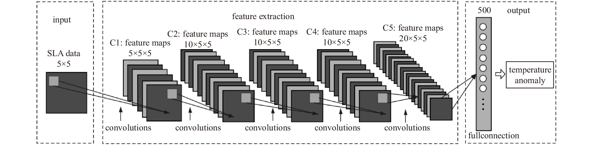
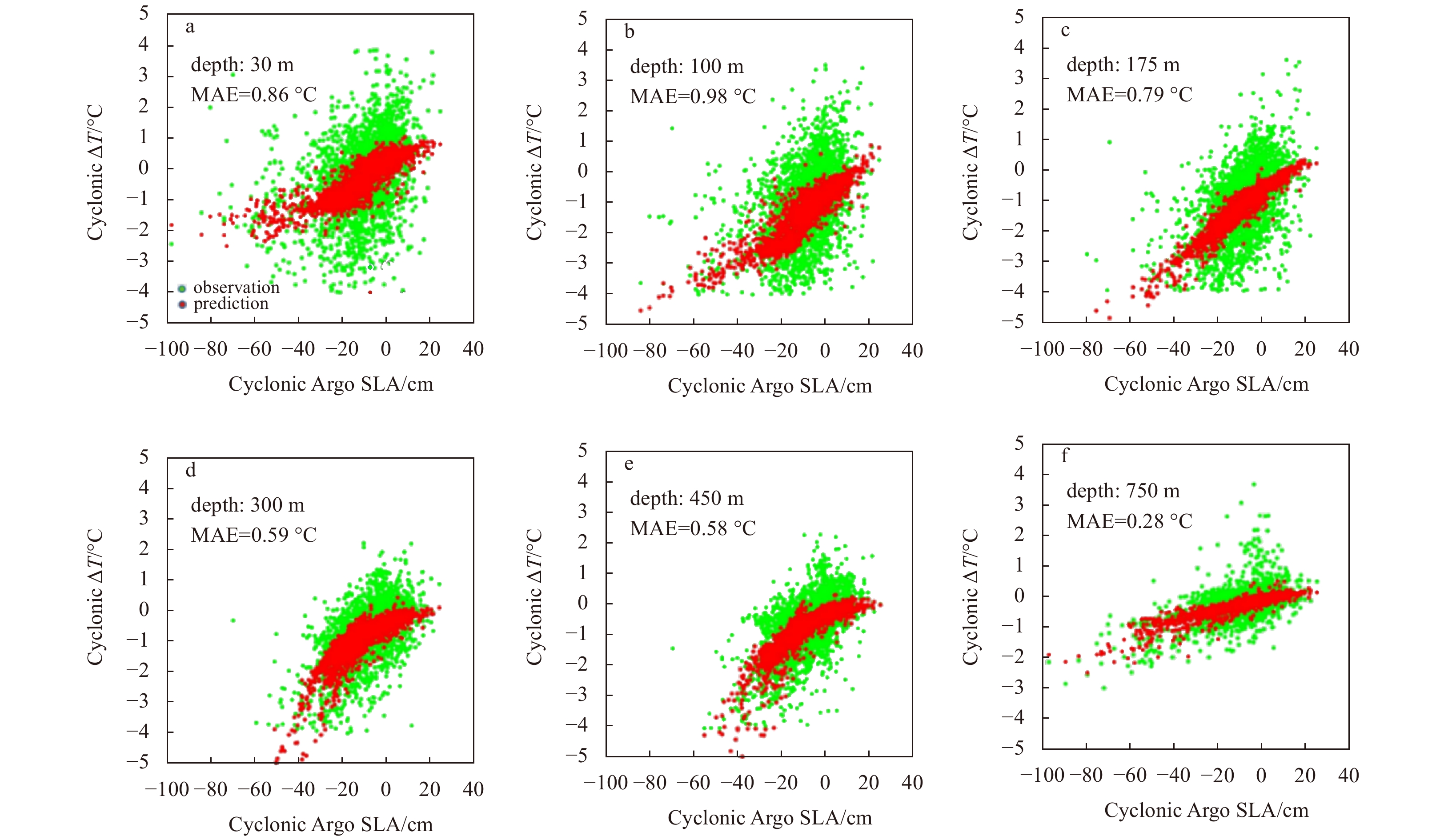
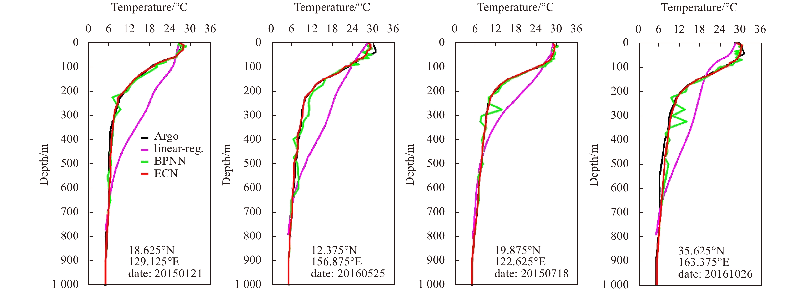
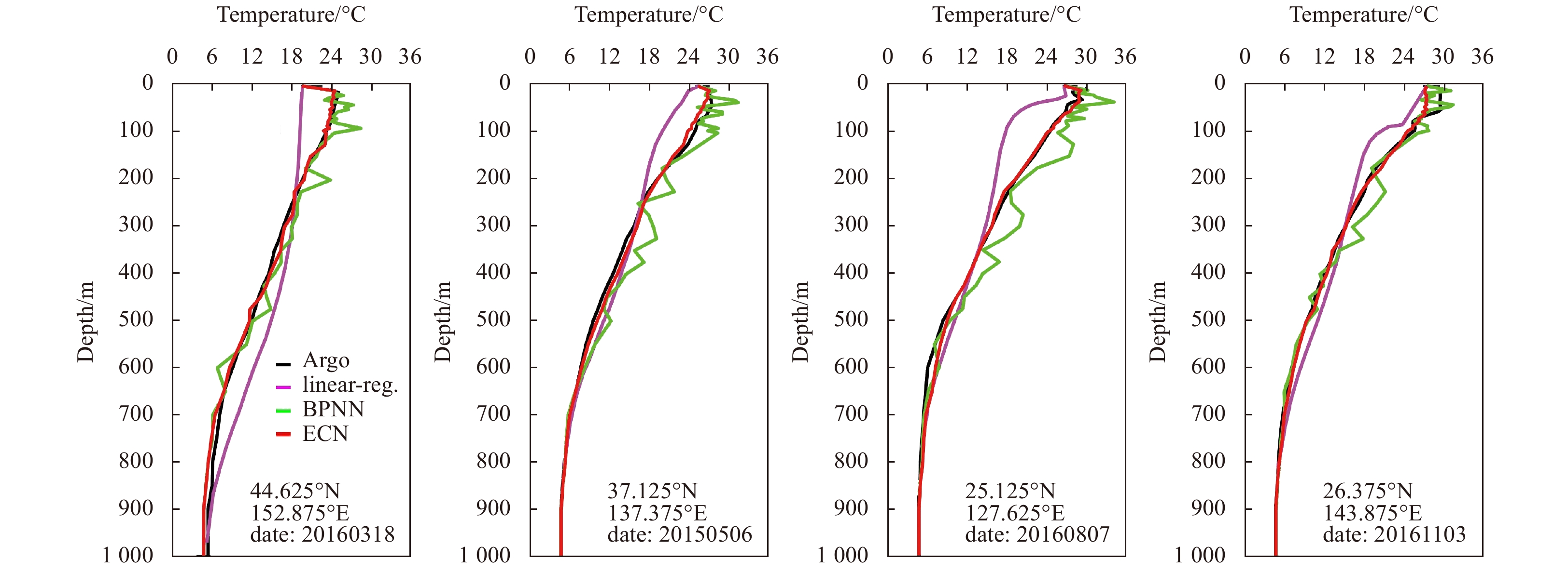
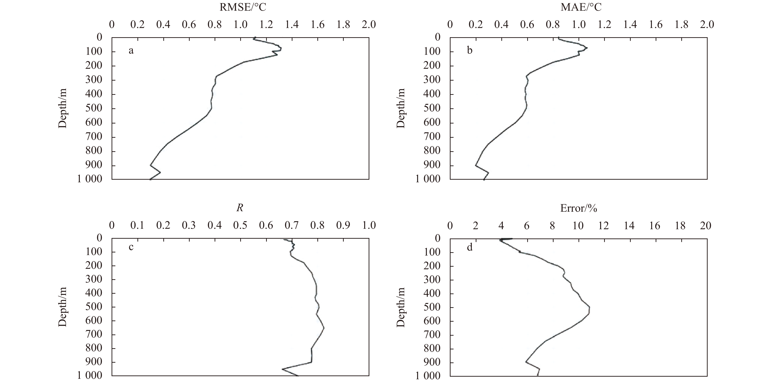
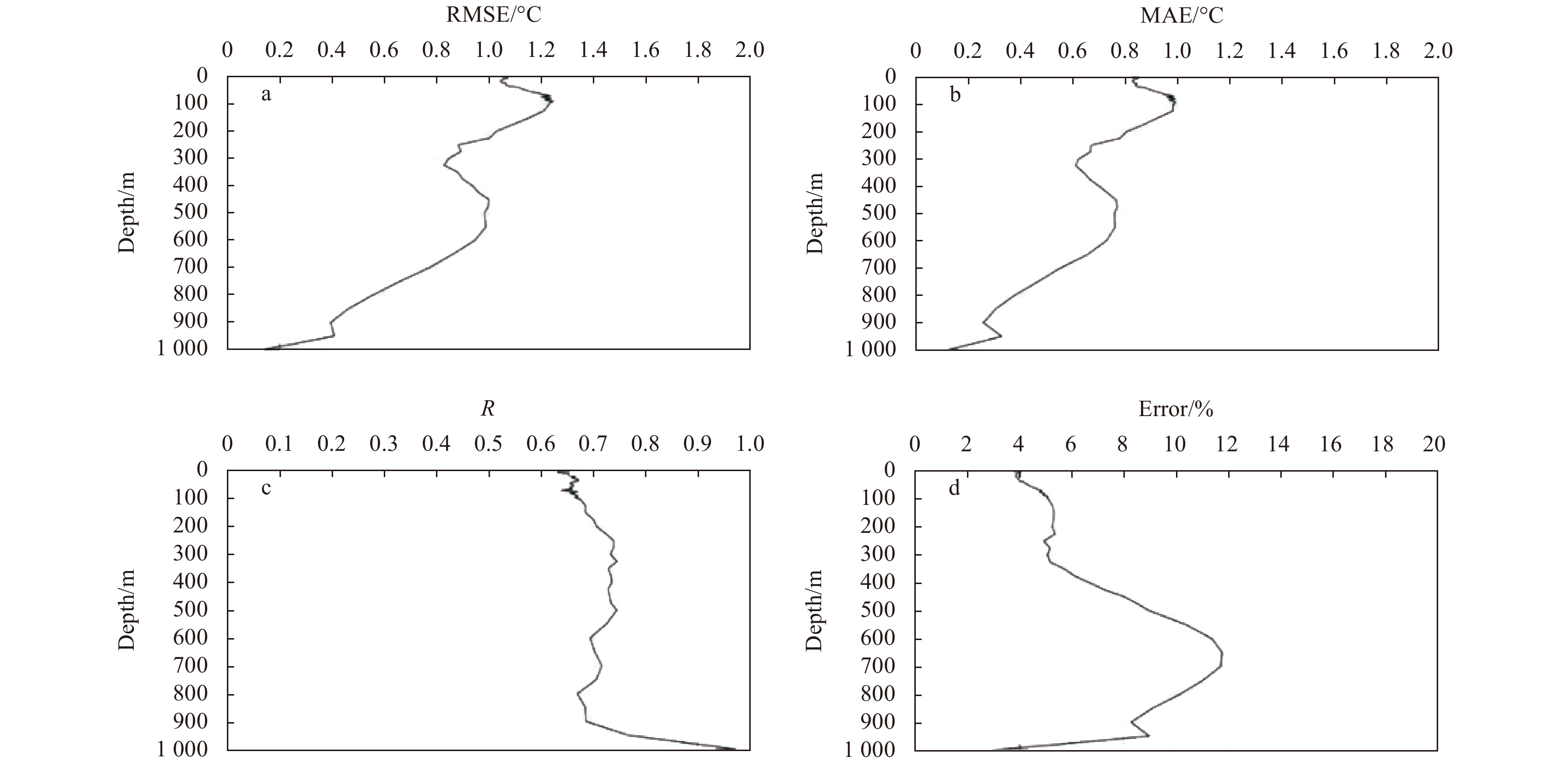
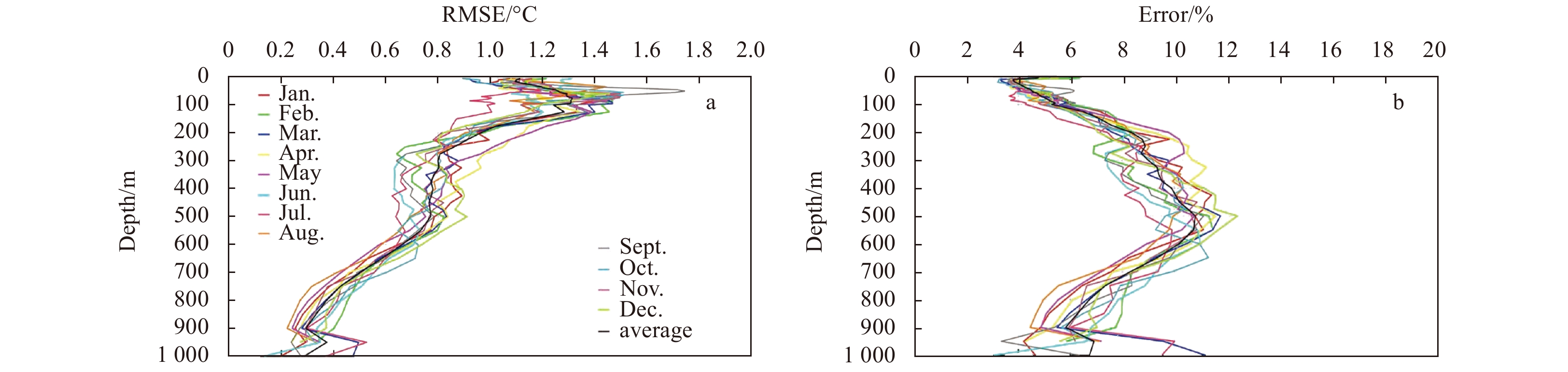
Mesoscale eddies, which are mainly caused by baroclinic effects in the ocean, are common oceanic phenomena in the Northwest Pacific Ocean and play very important roles in ocean circulation, ocean dynamics and material energy transport. The temperature structure of mesoscale eddies will lead to variations in oceanic baroclinity, which can be reflected in the sea level anomaly (SLA). Deep learning can automatically extract different features of data at multiple levels without human intervention, and find the hidden relations of data. Therefore, combining satellite SLA data with deep learning is a good way to invert the temperature structure inside eddies. This paper proposes a deep learning algorithm, eddy convolution neural network (ECN), which can train the relationship between mesoscale eddy temperature anomalies and sea level anomalies (SLAs), relying on the powerful feature extraction and learning abilities of convolutional neural networks. After obtaining the temperature structure model through ECN, according to climatic temperature data, the temperature structure of mesoscale eddies in the Northwest Pacific is retrieved with a spatial resolution of 0.25° at depths of 0–1 000 m. The overall accuracy of the ECN temperature structure is verified using Argo profiles at the locations of cyclonic and anticyclonic eddies during 2015–2016. Taking 10% error as the acceptable threshold of accuracy, 89.64% and 87.25% of the cyclonic and anticyclonic eddy temperature structures obtained by ECN met the threshold, respectively.
Mesoscale eddies, which are mainly caused by baroclinic effects in the ocean, are common oceanic phenomena in the Northwest Pacific Ocean and play very important roles in ocean circulation, ocean dynamics and material energy transport. The temperature structure of mesoscale eddies will lead to variations in oceanic baroclinity, which can be reflected in the sea level anomaly (SLA). Deep learning can automatically extract different features of data at multiple levels without human intervention, and find the hidden relations of data. Therefore, combining satellite SLA data with deep learning is a good way to invert the temperature structure inside eddies. This paper proposes a deep learning algorithm, eddy convolution neural network (ECN), which can train the relationship between mesoscale eddy temperature anomalies and sea level anomalies (SLAs), relying on the powerful feature extraction and learning abilities of convolutional neural networks. After obtaining the temperature structure model through ECN, according to climatic temperature data, the temperature structure of mesoscale eddies in the Northwest Pacific is retrieved with a spatial resolution of 0.25° at depths of 0–1 000 m. The overall accuracy of the ECN temperature structure is verified using Argo profiles at the locations of cyclonic and anticyclonic eddies during 2015–2016. Taking 10% error as the acceptable threshold of accuracy, 89.64% and 87.25% of the cyclonic and anticyclonic eddy temperature structures obtained by ECN met the threshold, respectively.


2021, 40(10): 187-196.
doi: 10.1007/s13131-021-1835-x
Abstract:
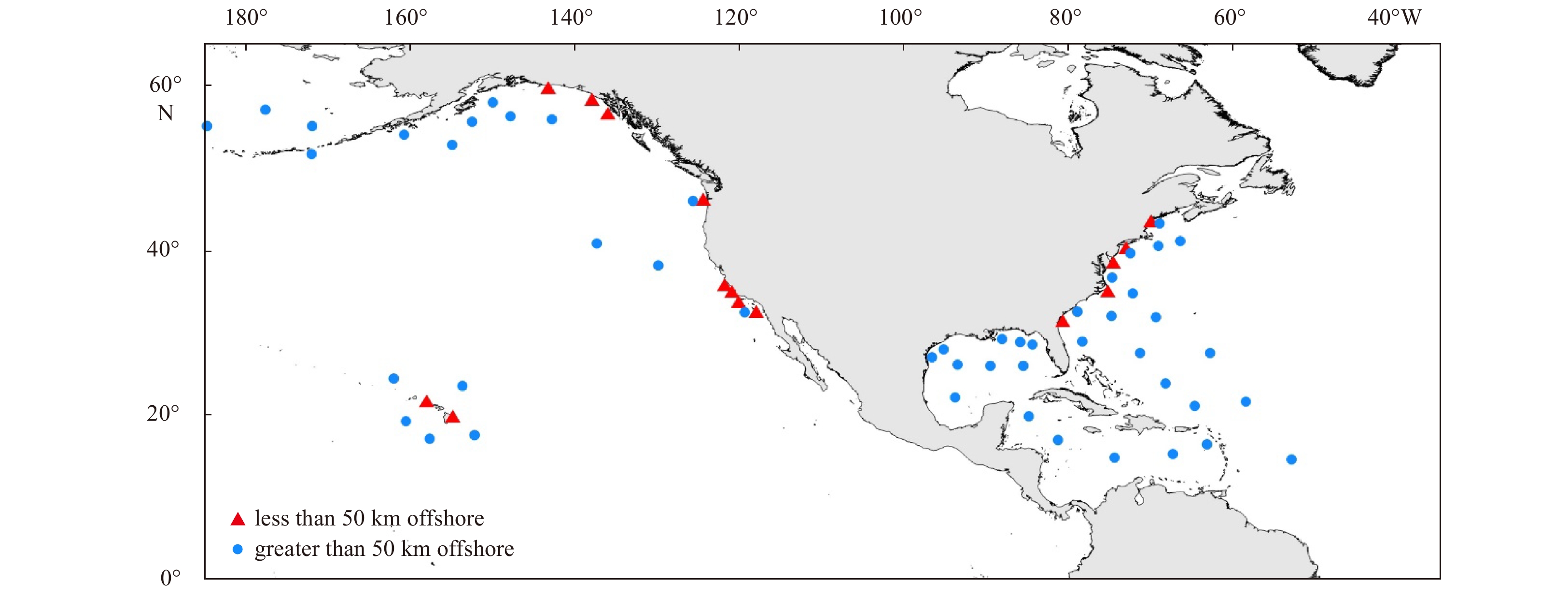
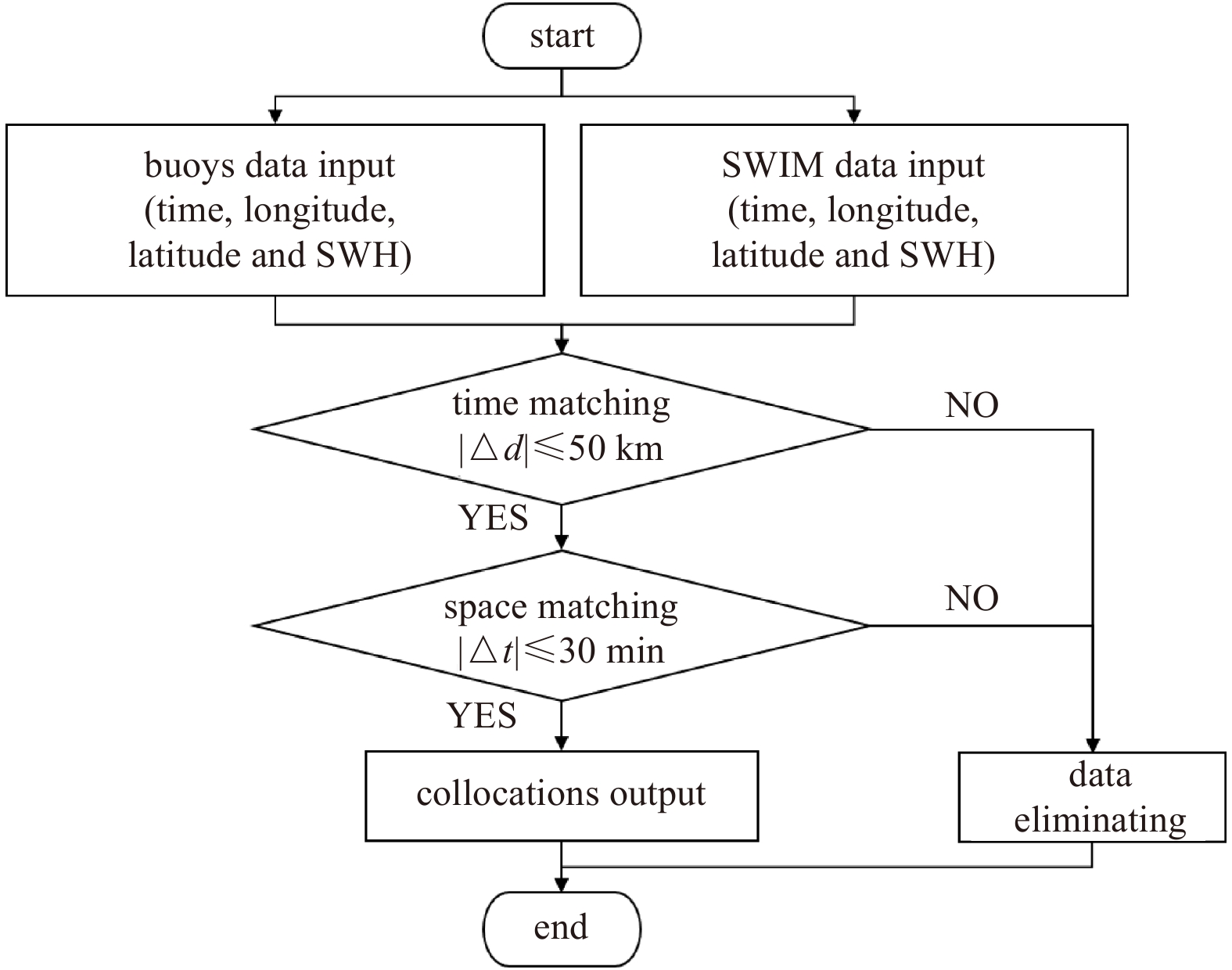
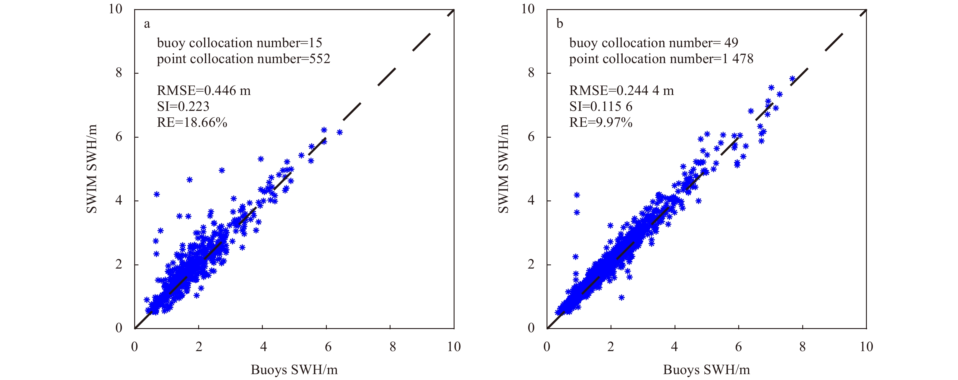
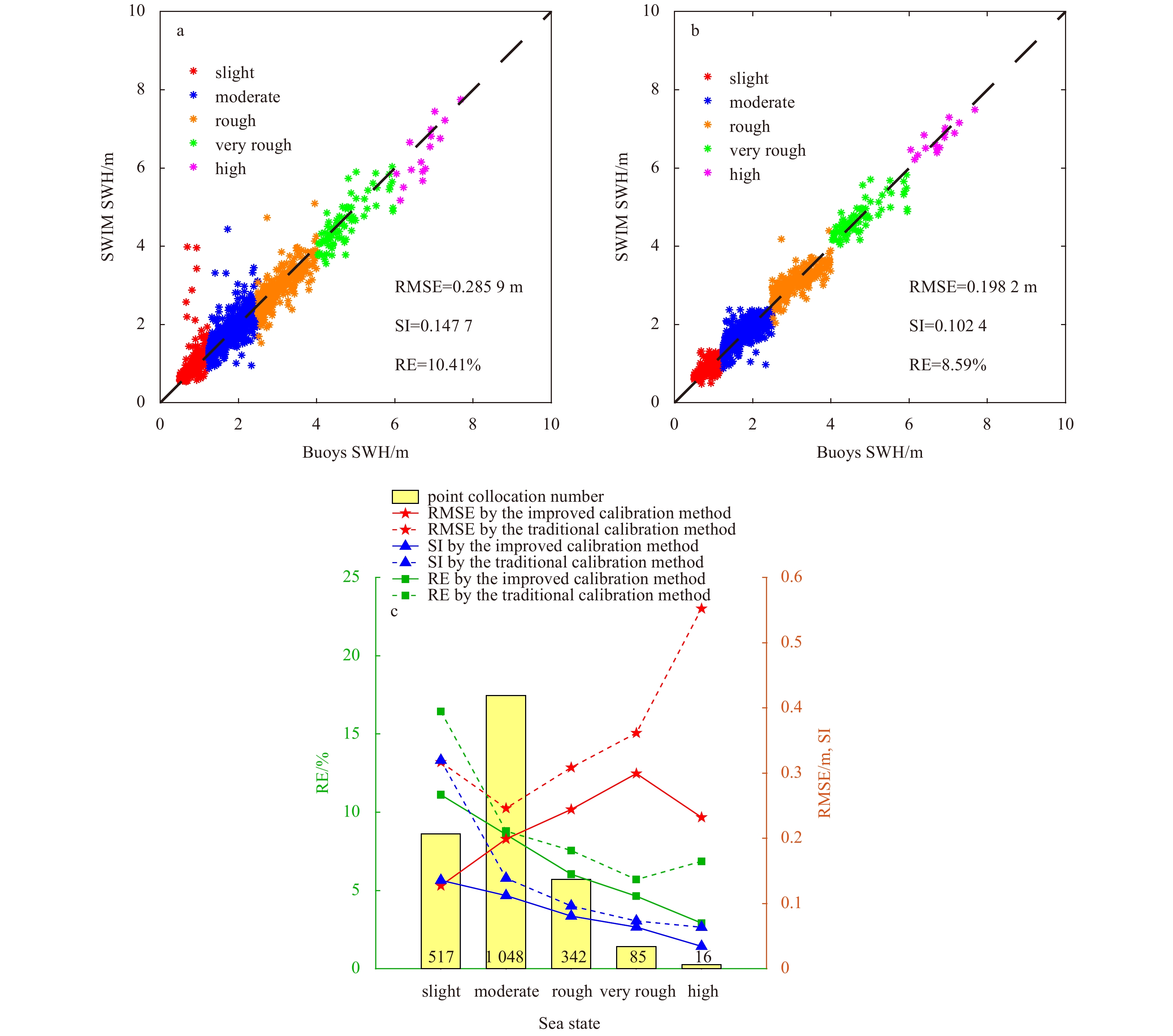
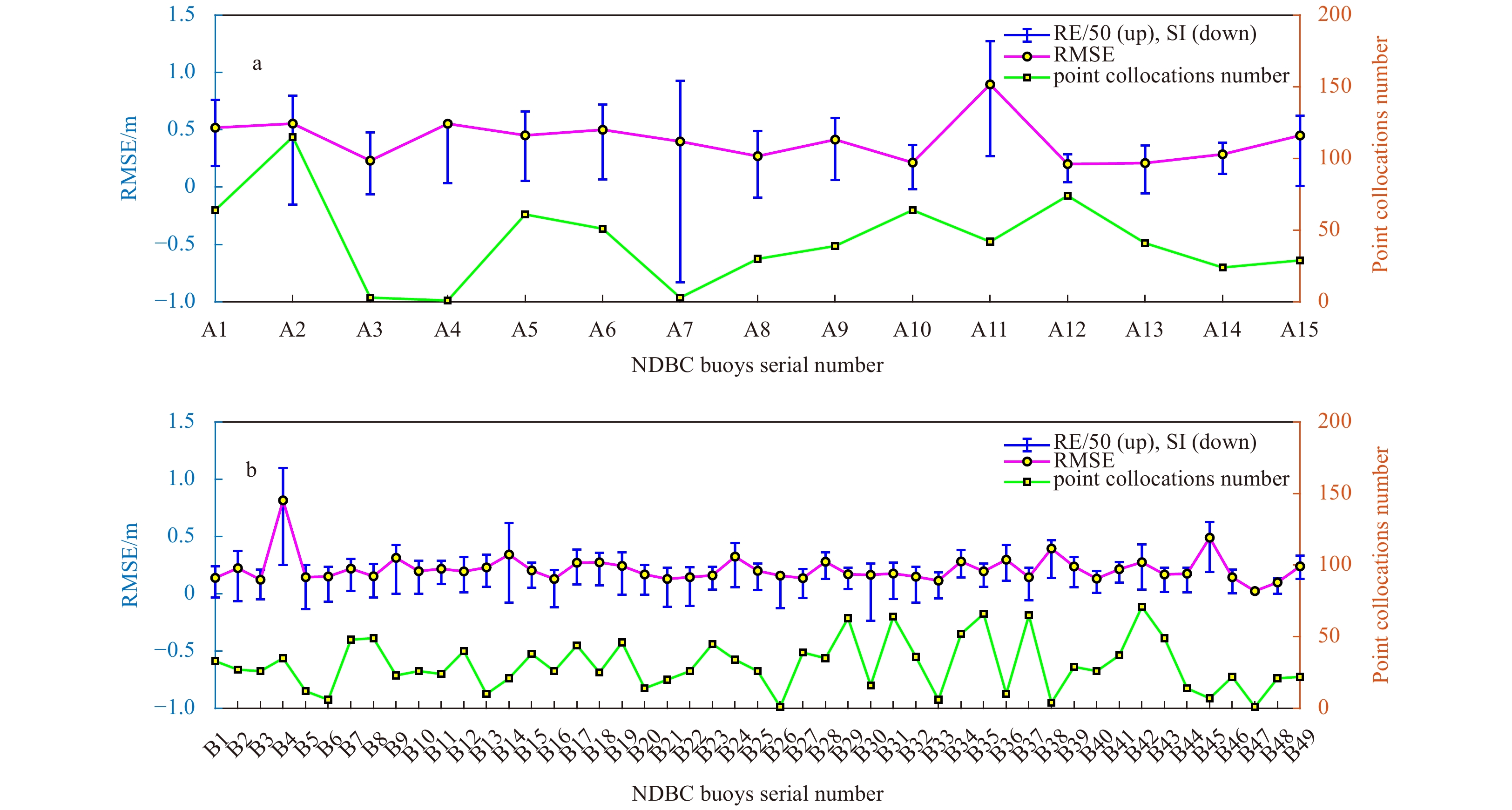
The significant wave height (SWH) is one of the main parameters that describe wave characteristics and is widely used in wave research fields. Wave parameters measured by radar are influenced by the offshore distance and sea state. Validation and calibration are of great significance for radar data applications. The nadir beam of surface wave investigation and monitoring (SWIM) detects the global-ocean-surface SWH. To determine the product quality of SWIM SWH, this paper carried out time-space matching between SWIM and buoy data. The data qualities were evaluated under different offshore distances and sea states. An improved calibration method was proposed based on sea state segmentation, which considered the distribution of the point collocation numbers in various sea states. The results indicate that (1) the SWIM SWH accuracy at offshore distances greater than 50 km is higher than that at distances less than 50 km, with an root mean squared error (RMSE) of 0.244 4 m, scatter index (SI) of 0.115 6 and relative error (RE) of 9.97% at distances greater than 50 km and those of 0.446 0 m, 0.223 0 and 18.66% at distances less than 50 km. (2) SWIM SWH qualities are better in moderate and rough sea states with RMSEs of 0.284 8 m and 0.316 9 m but are worse in slight and very rough sea states. (3) The effect of the improved calibration method is superior to the traditional method in each sea state and overall data, and the RMSE of SWIM SWH is reduced from the raw 0.313 5 m to 0.285 9 m by the traditional method and 0.198 2 m by the improved method. The influence of spatiotemporal window selection on data quality evaluation was analyzed in this paper. This paper provides references for SWIM SWH product applications.
The significant wave height (SWH) is one of the main parameters that describe wave characteristics and is widely used in wave research fields. Wave parameters measured by radar are influenced by the offshore distance and sea state. Validation and calibration are of great significance for radar data applications. The nadir beam of surface wave investigation and monitoring (SWIM) detects the global-ocean-surface SWH. To determine the product quality of SWIM SWH, this paper carried out time-space matching between SWIM and buoy data. The data qualities were evaluated under different offshore distances and sea states. An improved calibration method was proposed based on sea state segmentation, which considered the distribution of the point collocation numbers in various sea states. The results indicate that (1) the SWIM SWH accuracy at offshore distances greater than 50 km is higher than that at distances less than 50 km, with an root mean squared error (RMSE) of 0.244 4 m, scatter index (SI) of 0.115 6 and relative error (RE) of 9.97% at distances greater than 50 km and those of 0.446 0 m, 0.223 0 and 18.66% at distances less than 50 km. (2) SWIM SWH qualities are better in moderate and rough sea states with RMSEs of 0.284 8 m and 0.316 9 m but are worse in slight and very rough sea states. (3) The effect of the improved calibration method is superior to the traditional method in each sea state and overall data, and the RMSE of SWIM SWH is reduced from the raw 0.313 5 m to 0.285 9 m by the traditional method and 0.198 2 m by the improved method. The influence of spatiotemporal window selection on data quality evaluation was analyzed in this paper. This paper provides references for SWIM SWH product applications.