2020 Vol. 39, No. 3
Display Method:
2020, 39(3): .
Abstract:
2020, 39(3): .
Abstract:
2020, 39(3): 1-11.
doi: 10.1007/s13131-020-1538-8
Abstract:
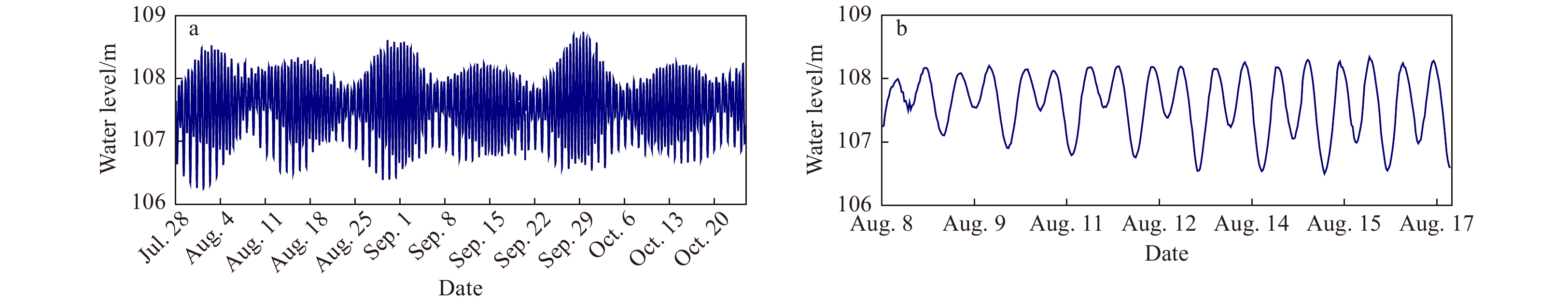
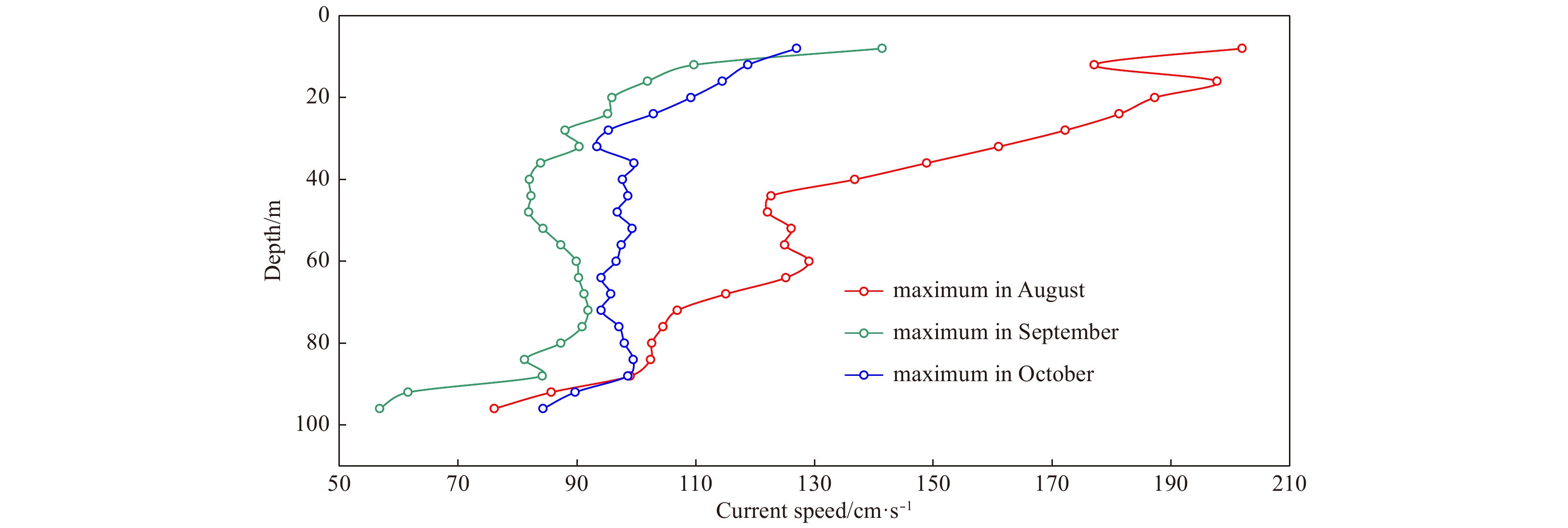
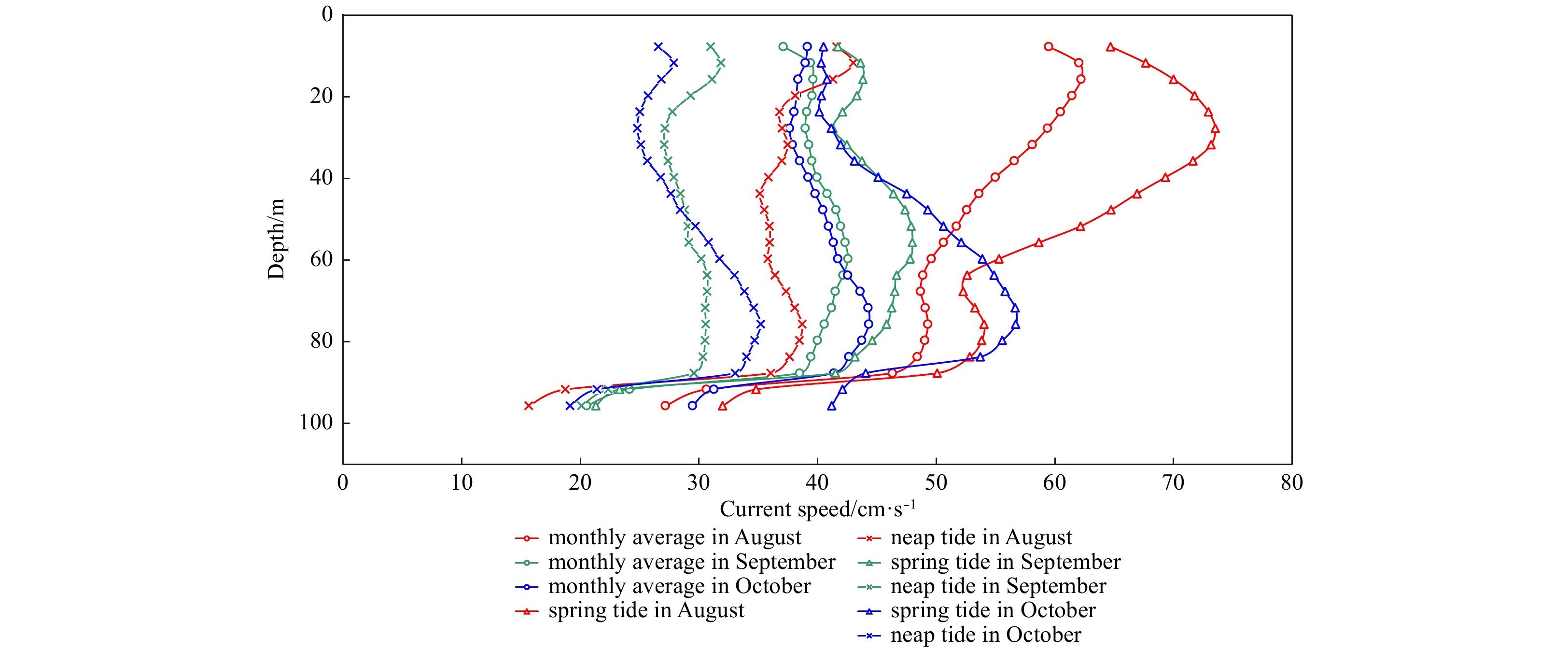
Current characteristics and vertical variations during summer and autumn in the southern East China Sea were investigated by measuring current profile, tide, wind, and wave data for 90 d from July 28 to October 25, 2015. Our results are: (1) The current was mainly a (clockwise) rotating flow, displaying reciprocating flow characteristics, and vertically the current directions were the same throughout the vertical profile. (2) The horizontal current speed was strongest during August (summer) with an average speed of 51.8 cm/s. The average current speeds during spring tides were highest in August and weakest in September, with speeds of 59.9 and 42.8 cm/s, respectively. (3) Considerable differences exist in average current speeds in different layers and seasons. The highest average current speeds were found in the middle–upper layers in August and in the middle–lower layers in September and October. (4) The residual current speed was highest in August, when the speed was 12.5–47.1 cm/s, whereas the vertical average current speed was 34.3 cm/s. The depth-averaged residual current speeds in September and October were only 50% of that in August, and the residual current direction gradually rotated in a counter-clockwise direction from the lower to surface layers. (5) Typhoon waves had a significant influence on the currents, and even affected the middle and lower water layers at depths of >70.0 m. Our results showed that the currents are controlled by the dynamic interplay of the Taiwan Warm Current, incursion of the Kuroshio Current onto the continental shelf, and monsoonal changes.
Current characteristics and vertical variations during summer and autumn in the southern East China Sea were investigated by measuring current profile, tide, wind, and wave data for 90 d from July 28 to October 25, 2015. Our results are: (1) The current was mainly a (clockwise) rotating flow, displaying reciprocating flow characteristics, and vertically the current directions were the same throughout the vertical profile. (2) The horizontal current speed was strongest during August (summer) with an average speed of 51.8 cm/s. The average current speeds during spring tides were highest in August and weakest in September, with speeds of 59.9 and 42.8 cm/s, respectively. (3) Considerable differences exist in average current speeds in different layers and seasons. The highest average current speeds were found in the middle–upper layers in August and in the middle–lower layers in September and October. (4) The residual current speed was highest in August, when the speed was 12.5–47.1 cm/s, whereas the vertical average current speed was 34.3 cm/s. The depth-averaged residual current speeds in September and October were only 50% of that in August, and the residual current direction gradually rotated in a counter-clockwise direction from the lower to surface layers. (5) Typhoon waves had a significant influence on the currents, and even affected the middle and lower water layers at depths of >70.0 m. Our results showed that the currents are controlled by the dynamic interplay of the Taiwan Warm Current, incursion of the Kuroshio Current onto the continental shelf, and monsoonal changes.


2020, 39(3): 12-24.
doi: 10.1007/s13131-020-1565-5
Abstract:
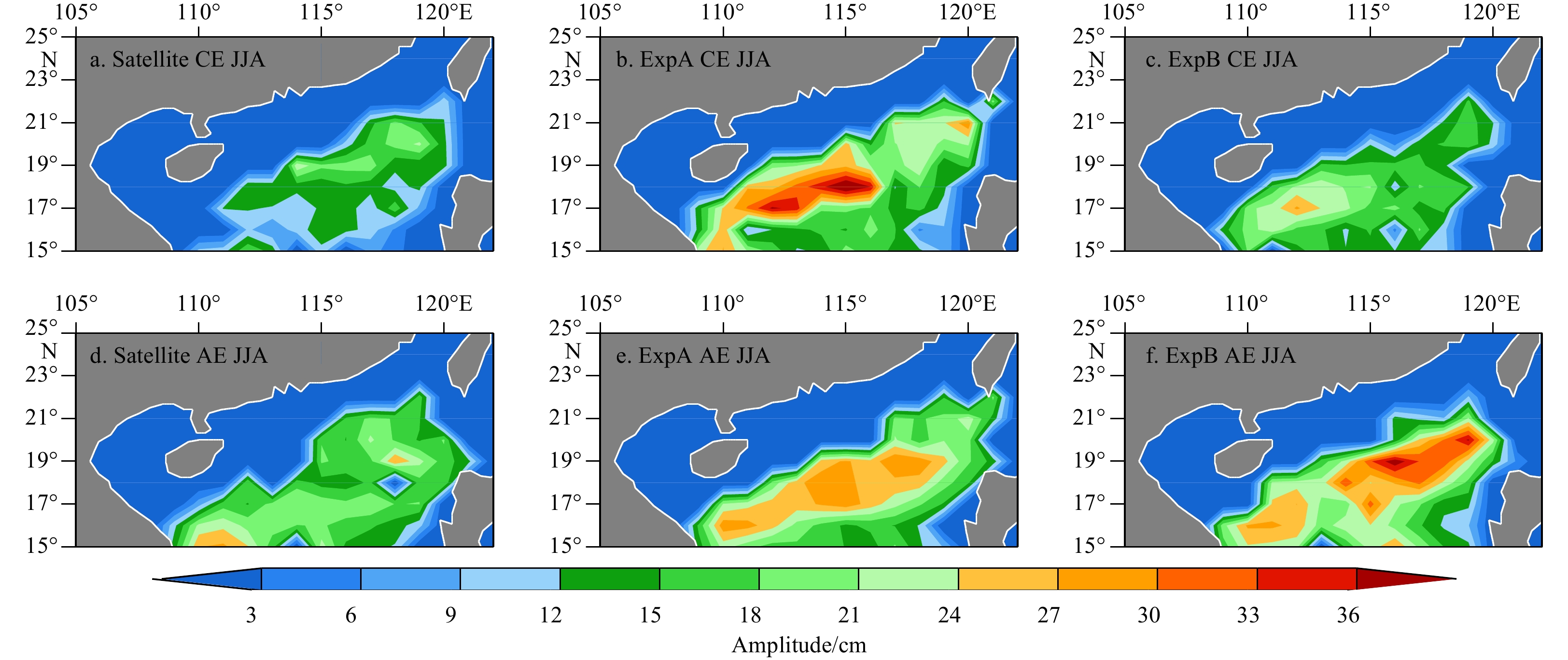
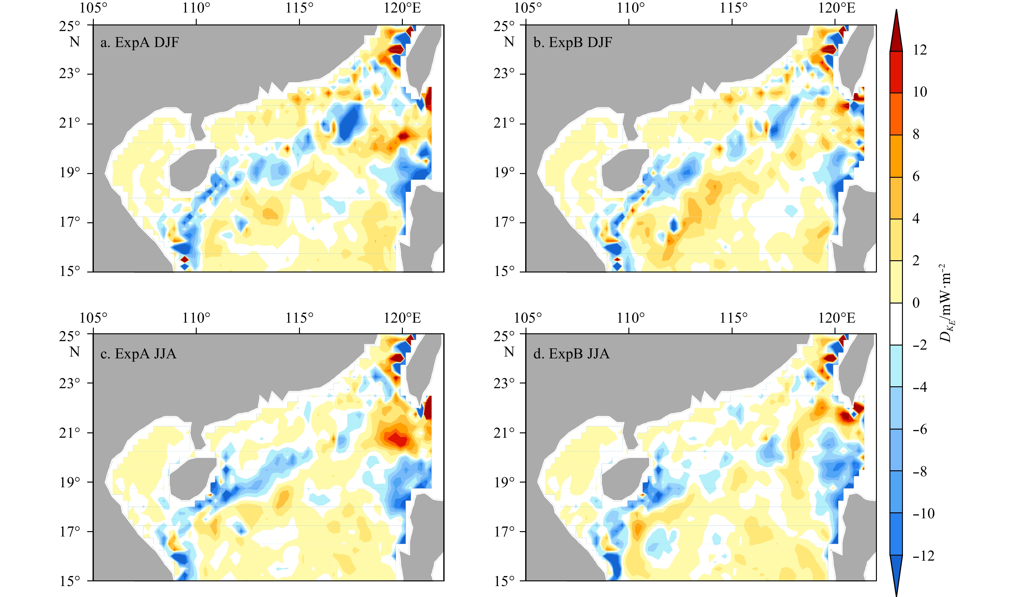
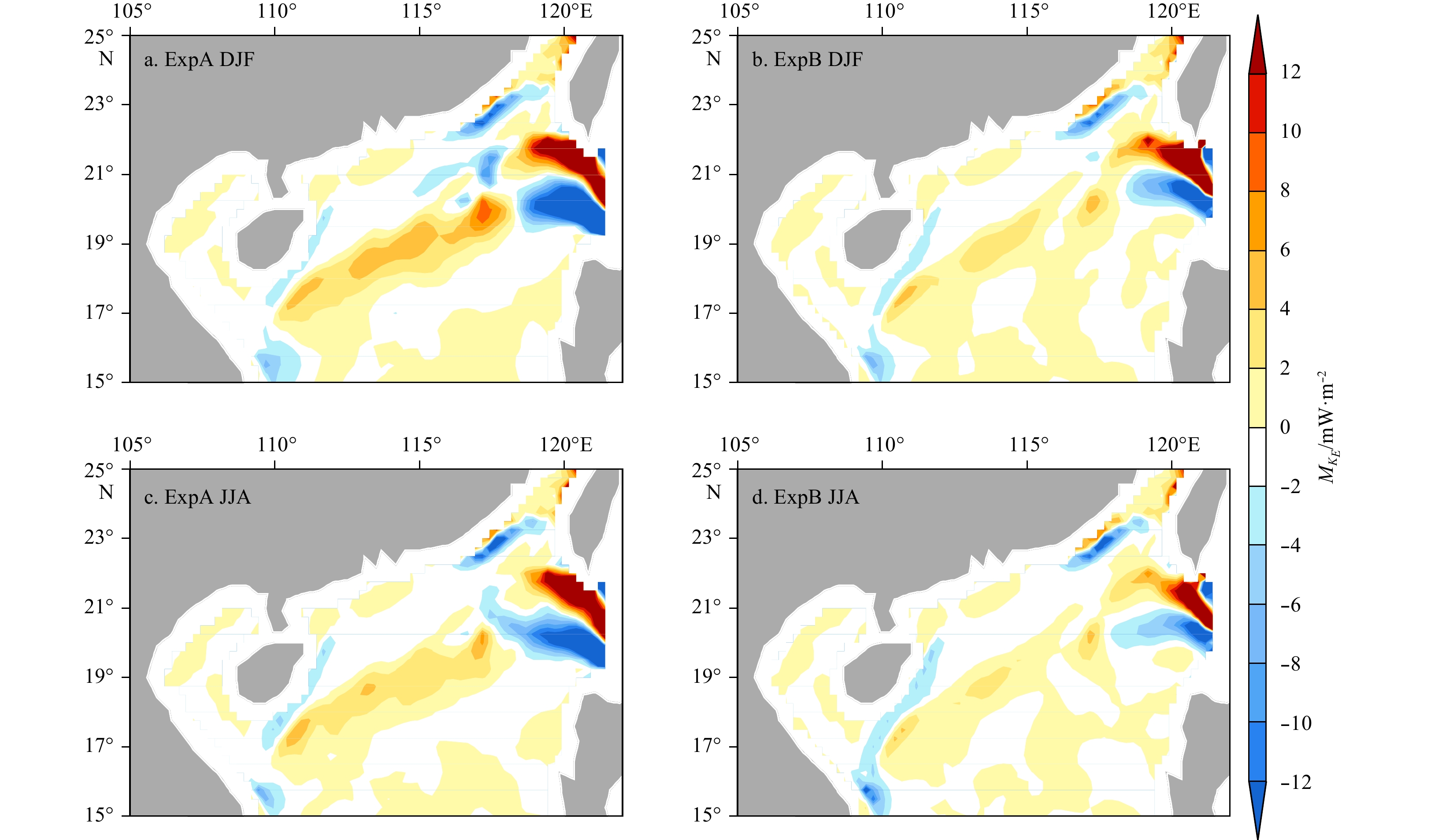
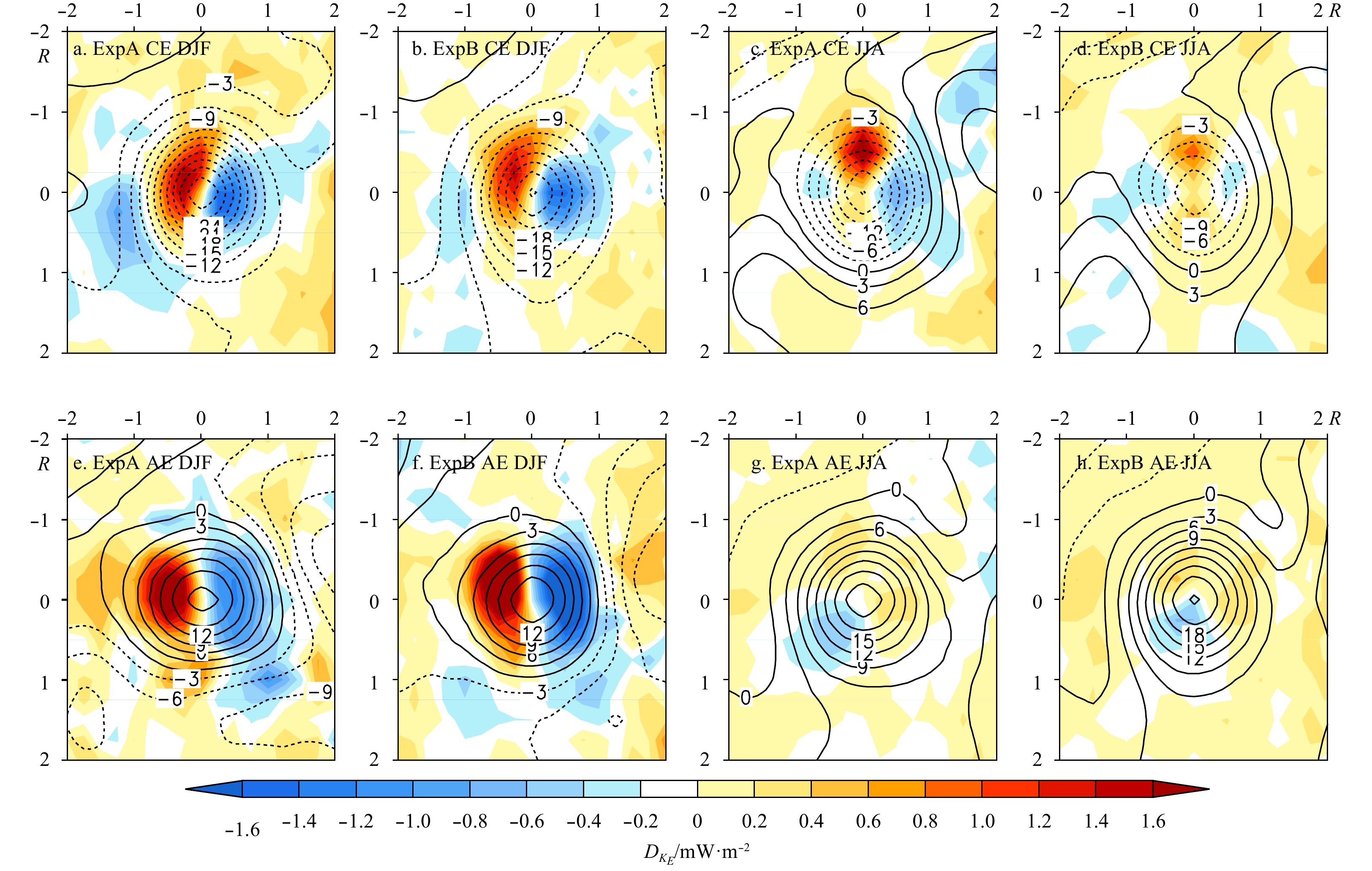
The impacts of Kuroshio intrusion (KI) optimization on the simulation of meso-scale eddies (MEs) in the northern South China Sea (SCS) were investigated based on an eddy-resolving ocean general circulation model by comparing two numerical experiments with differences in their form and intensity of KI due to the optimizing topography at Luzon Strait (LS). We found that a reduced KI reduces ME activities in the northern SCS, which is similar to the observations. In this case, the biases of the model related to simulating the eddy kinetic energy (EKE) west of the LS and along the northern slope are remarkably attenuated. The reduced EKE modeling bias is associated with both the reduced number of anti-cyclonic eddies (AEs) and the reduced amplitude of cyclonic eddies (CEs). The EKE budget analysis further suggests that the optimization of the KI will change the EKE by changing the horizontal velocity shear and the slope of the thermocline, which are related to barotropic and baroclinic instabilities, respectively. The former plays the key role in regulating the EKE in the northern SCS due to the changing of the KI. The EKE advection caused by the KI is also important for the EKE budget to the west of the LS.
The impacts of Kuroshio intrusion (KI) optimization on the simulation of meso-scale eddies (MEs) in the northern South China Sea (SCS) were investigated based on an eddy-resolving ocean general circulation model by comparing two numerical experiments with differences in their form and intensity of KI due to the optimizing topography at Luzon Strait (LS). We found that a reduced KI reduces ME activities in the northern SCS, which is similar to the observations. In this case, the biases of the model related to simulating the eddy kinetic energy (EKE) west of the LS and along the northern slope are remarkably attenuated. The reduced EKE modeling bias is associated with both the reduced number of anti-cyclonic eddies (AEs) and the reduced amplitude of cyclonic eddies (CEs). The EKE budget analysis further suggests that the optimization of the KI will change the EKE by changing the horizontal velocity shear and the slope of the thermocline, which are related to barotropic and baroclinic instabilities, respectively. The former plays the key role in regulating the EKE in the northern SCS due to the changing of the KI. The EKE advection caused by the KI is also important for the EKE budget to the west of the LS.


2020, 39(3): 25-35.
doi: 10.1007/s13131-020-1559-3
Abstract:
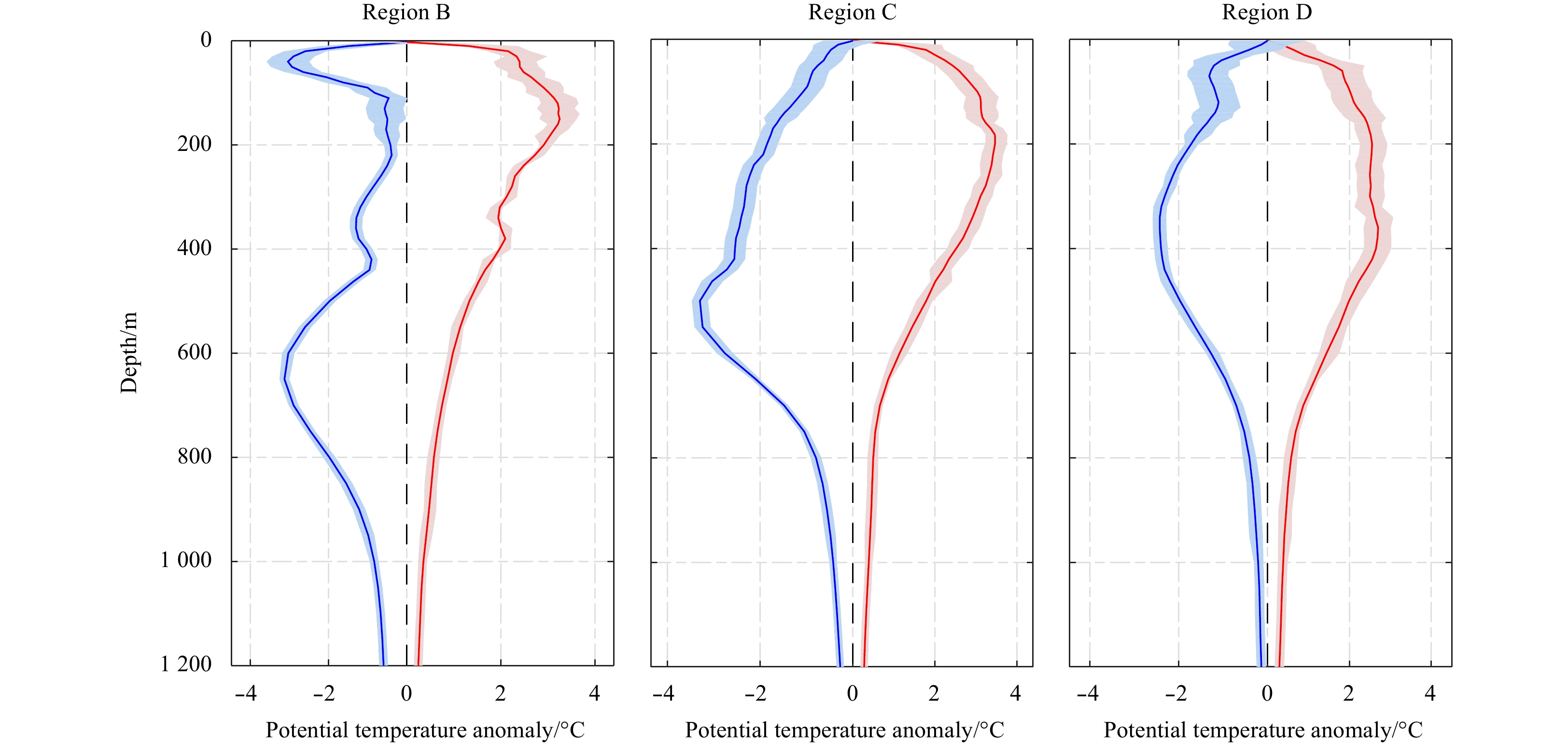
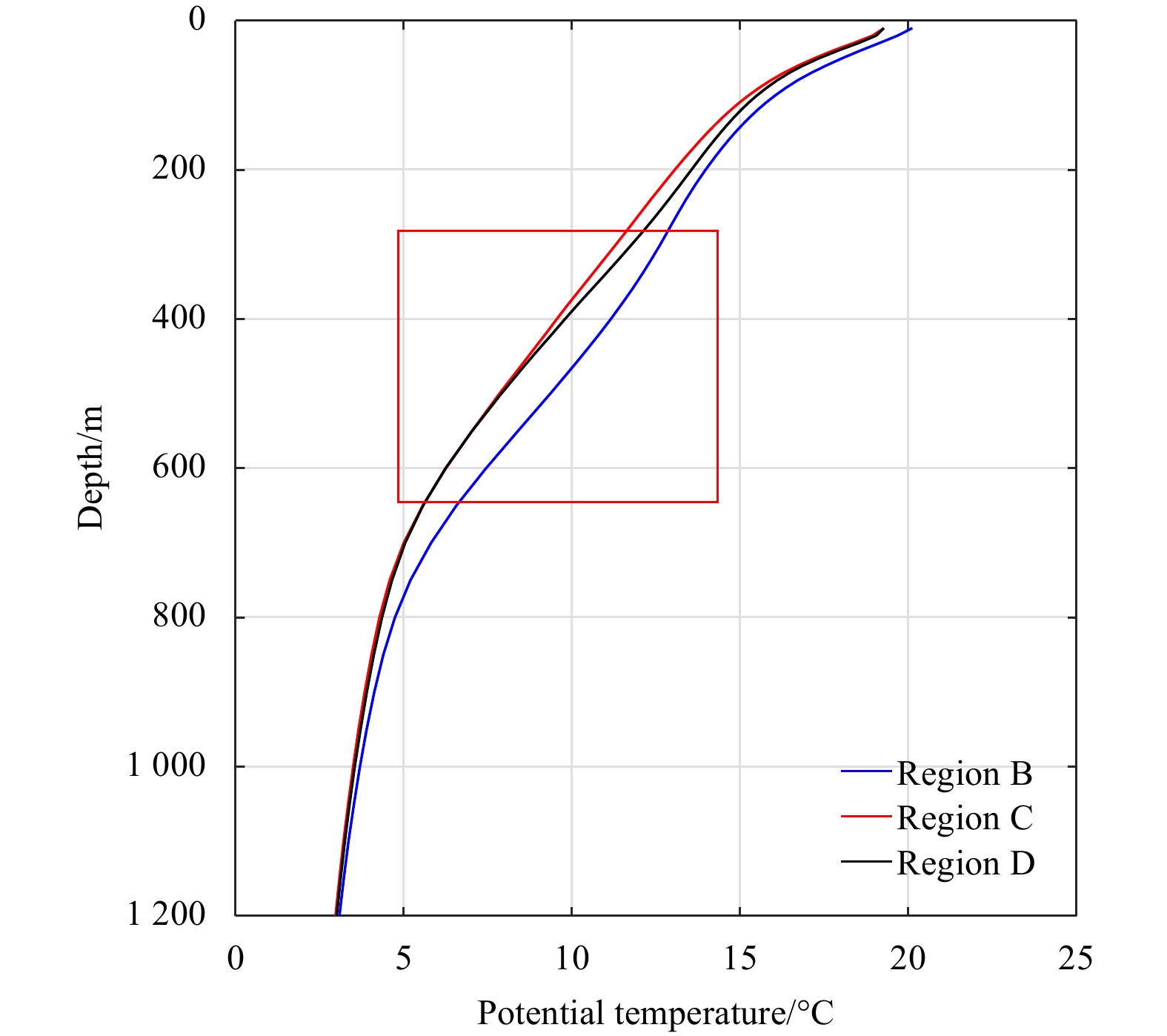
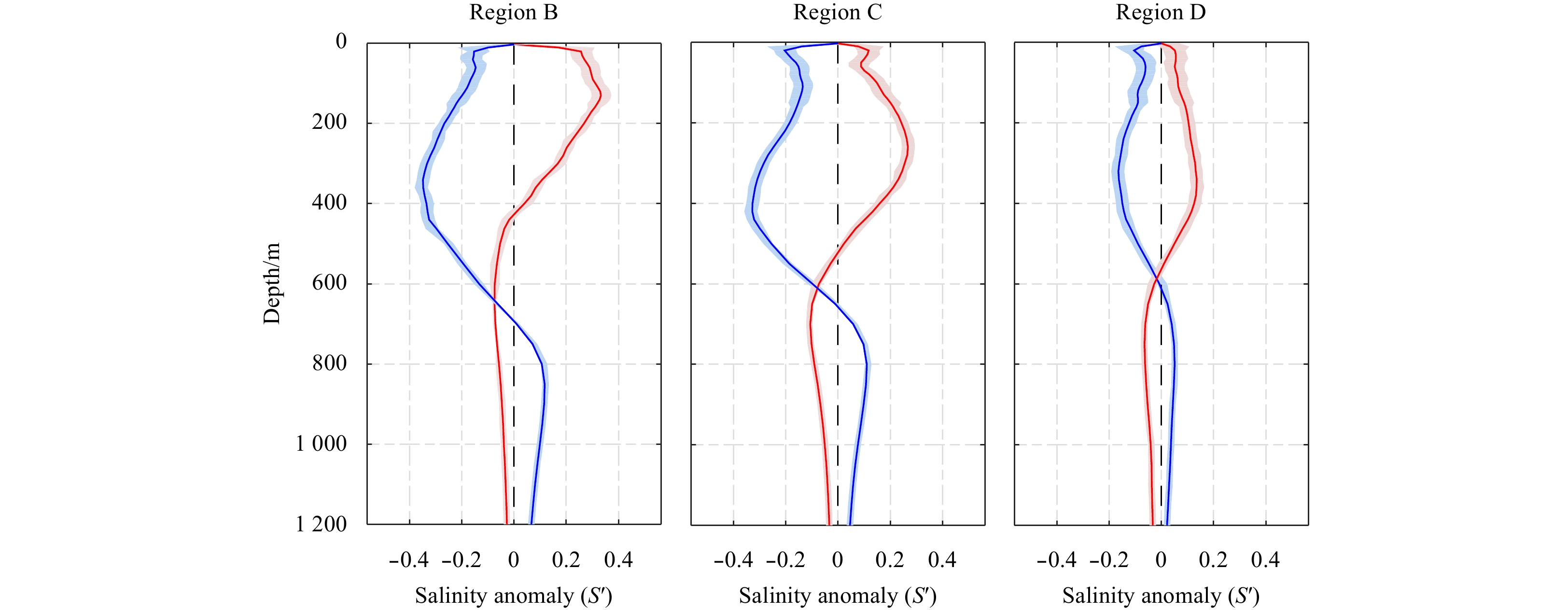
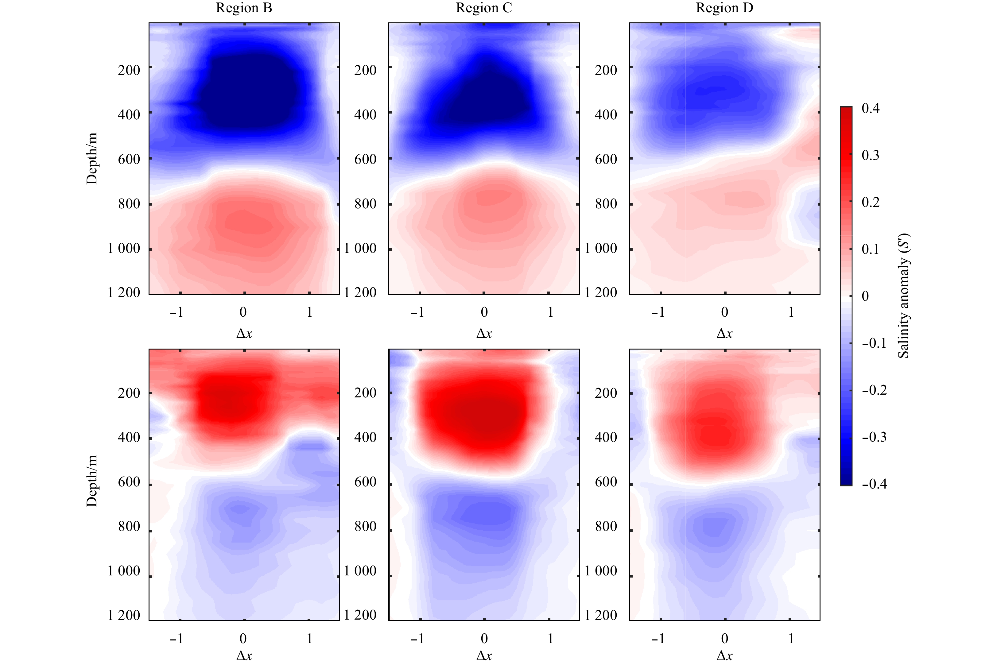
Using AVISO satellite altimeter observations during 1993–2015 and a manual eddy detection method, a total of 276 anticyclonic rings and 242 cyclonic rings shed from the Kuroshio Extension (KE) were identified, and their three-dimensional (3D) anomaly structures were further reconstructd based on the Argo float data and the Japan Agency for Marine-Earth Science and Technology (JAMSTEC) cruise and buoy data through an interpolation method. It is found that the cyclonic (anticyclonic) rings presented consistent negative (positive) anomalies of potential temperature; meanwhile the relevant maximum anomaly center became increasingly shallow for the cyclonic rings whereas it went deeper for the anticyclonic rings as the potential temperature anomaly decreased from the west to the east. The above deepening or shoaling trend is associated with the zonal change of the depth of the main thermocline. Moreover, the composite cold ring between 140° and 150°E was found to exhibit a double-core vertical structure due to the existence of mode water with low potential vorticity. Specifically, a relatively large negative (positive) salinity anomaly and a small positive (negative) one appeared for the composite cyclonic (anticyclonic) ring at the depth above and below 600 m, respectively. The underlying driving force for the temperature and salinity anomaly of the composite rings was also attempted, which varies depending on the intensity of the background current and the temperature and salinity fields in different areas of the KE region, and the rings’ influences on the temperature and salinity could reach deeper than 1 000 m on average.
Using AVISO satellite altimeter observations during 1993–2015 and a manual eddy detection method, a total of 276 anticyclonic rings and 242 cyclonic rings shed from the Kuroshio Extension (KE) were identified, and their three-dimensional (3D) anomaly structures were further reconstructd based on the Argo float data and the Japan Agency for Marine-Earth Science and Technology (JAMSTEC) cruise and buoy data through an interpolation method. It is found that the cyclonic (anticyclonic) rings presented consistent negative (positive) anomalies of potential temperature; meanwhile the relevant maximum anomaly center became increasingly shallow for the cyclonic rings whereas it went deeper for the anticyclonic rings as the potential temperature anomaly decreased from the west to the east. The above deepening or shoaling trend is associated with the zonal change of the depth of the main thermocline. Moreover, the composite cold ring between 140° and 150°E was found to exhibit a double-core vertical structure due to the existence of mode water with low potential vorticity. Specifically, a relatively large negative (positive) salinity anomaly and a small positive (negative) one appeared for the composite cyclonic (anticyclonic) ring at the depth above and below 600 m, respectively. The underlying driving force for the temperature and salinity anomaly of the composite rings was also attempted, which varies depending on the intensity of the background current and the temperature and salinity fields in different areas of the KE region, and the rings’ influences on the temperature and salinity could reach deeper than 1 000 m on average.


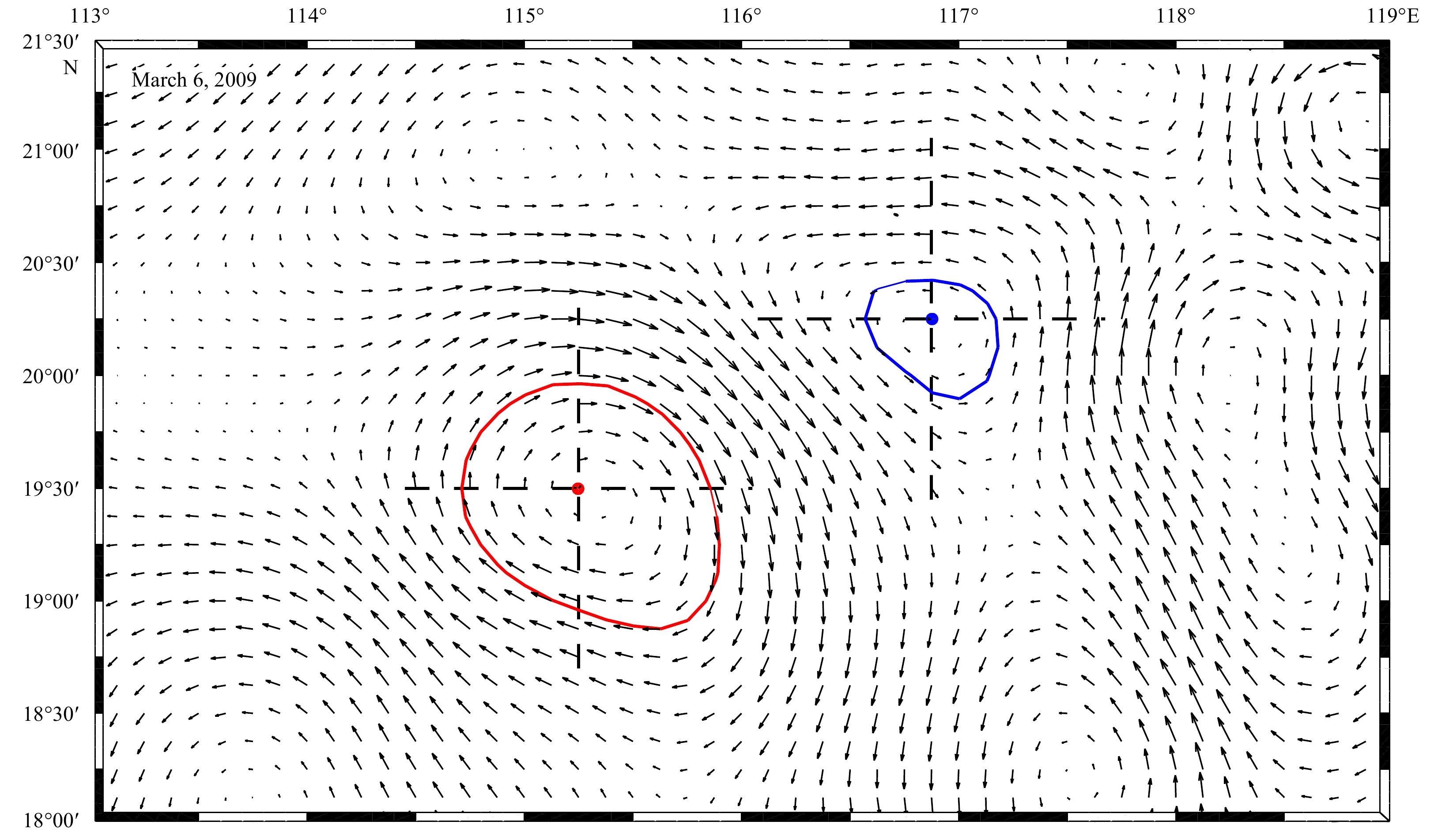
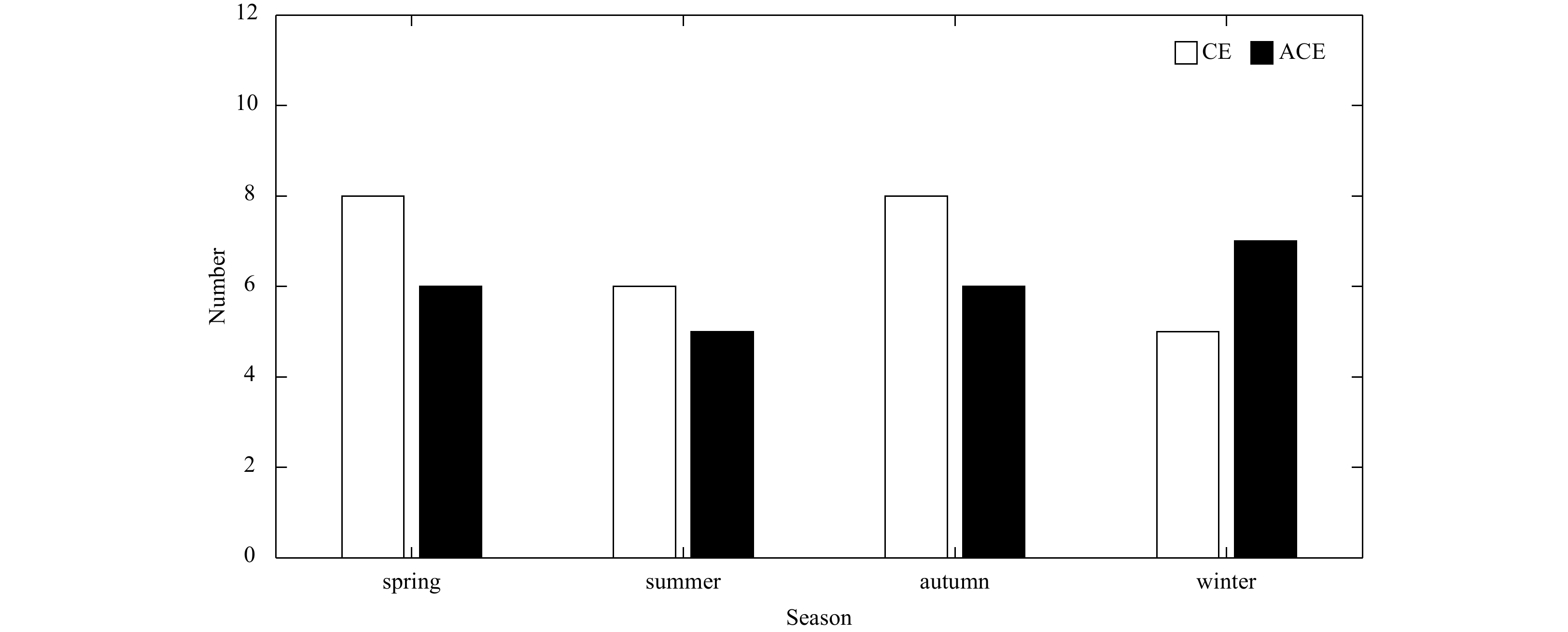
2020, 39(3): 36-44.
doi: 10.1007/s13131-019-1530-3
Abstract:
The continental slope in the northern South China Sea (SCS) is rich in mesoscale eddies which play an important role in transport and retention of nutrients and biota. In this study, we investigate the statistical properties of eddy distributions and propagation in a period of 24 years between 1993 and 2016 by using the altimeter data. A total of 147 eddies are found in the continental slope region (CSR), including 70 cyclonic eddies (CEs) and 77 anticyclonic eddies (ACEs). For those eddies that appear in the CSR, the surrounding areas of Dongsha Islands (DS) and southwest of Taiwan (SWT) are considered as the primary sources, where eddies generated contribute more than 60% of the total. According to the spatial distribution of eddy relative vorticity, eddies are weakening as propagating westward. Although both CEs and ACEs roughly propagate along the slope isobaths, there are discrepancies between CEs and ACEs. The ACEs move slightly faster in the zonal direction, while the CEs tend to cross the isobaths with large bottom depth change. The ACEs generally move further into the basin areas after leaving the CSR while CEs remain around the CSR. The eddy propagation on the continental slope is likely to be associated with mean flow at a certain degree because the eddy trajectories have notable seasonal signals that are consistent with the seasonal cycle of geostrophic current. The results indicate that the eddy translation speed is statistically consistent with geostrophic velocity in both magnitude and direction.
The continental slope in the northern South China Sea (SCS) is rich in mesoscale eddies which play an important role in transport and retention of nutrients and biota. In this study, we investigate the statistical properties of eddy distributions and propagation in a period of 24 years between 1993 and 2016 by using the altimeter data. A total of 147 eddies are found in the continental slope region (CSR), including 70 cyclonic eddies (CEs) and 77 anticyclonic eddies (ACEs). For those eddies that appear in the CSR, the surrounding areas of Dongsha Islands (DS) and southwest of Taiwan (SWT) are considered as the primary sources, where eddies generated contribute more than 60% of the total. According to the spatial distribution of eddy relative vorticity, eddies are weakening as propagating westward. Although both CEs and ACEs roughly propagate along the slope isobaths, there are discrepancies between CEs and ACEs. The ACEs move slightly faster in the zonal direction, while the CEs tend to cross the isobaths with large bottom depth change. The ACEs generally move further into the basin areas after leaving the CSR while CEs remain around the CSR. The eddy propagation on the continental slope is likely to be associated with mean flow at a certain degree because the eddy trajectories have notable seasonal signals that are consistent with the seasonal cycle of geostrophic current. The results indicate that the eddy translation speed is statistically consistent with geostrophic velocity in both magnitude and direction.


2020, 39(3): 45-55.
doi: 10.1007/s13131-020-1537-9
Abstract:
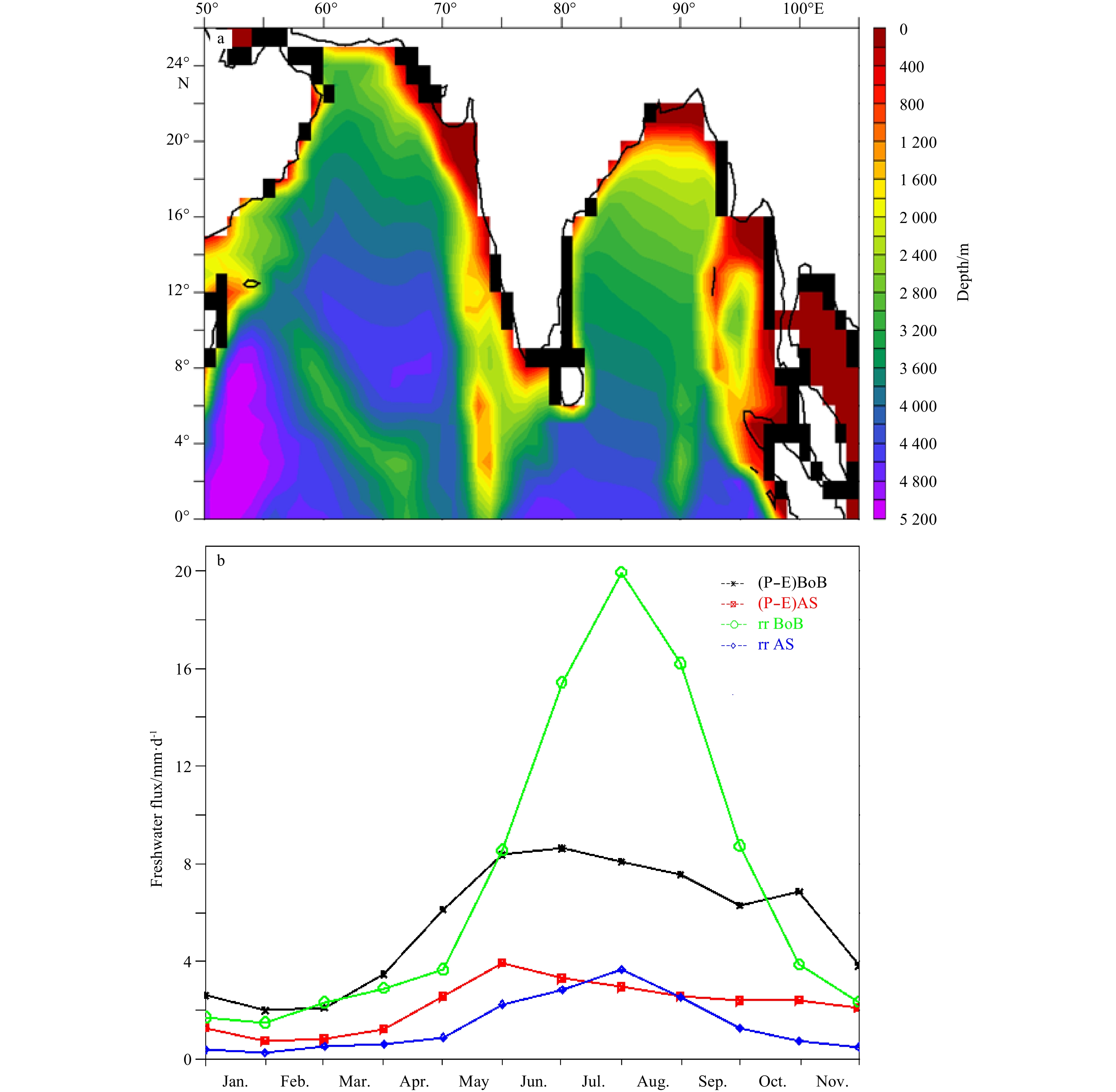
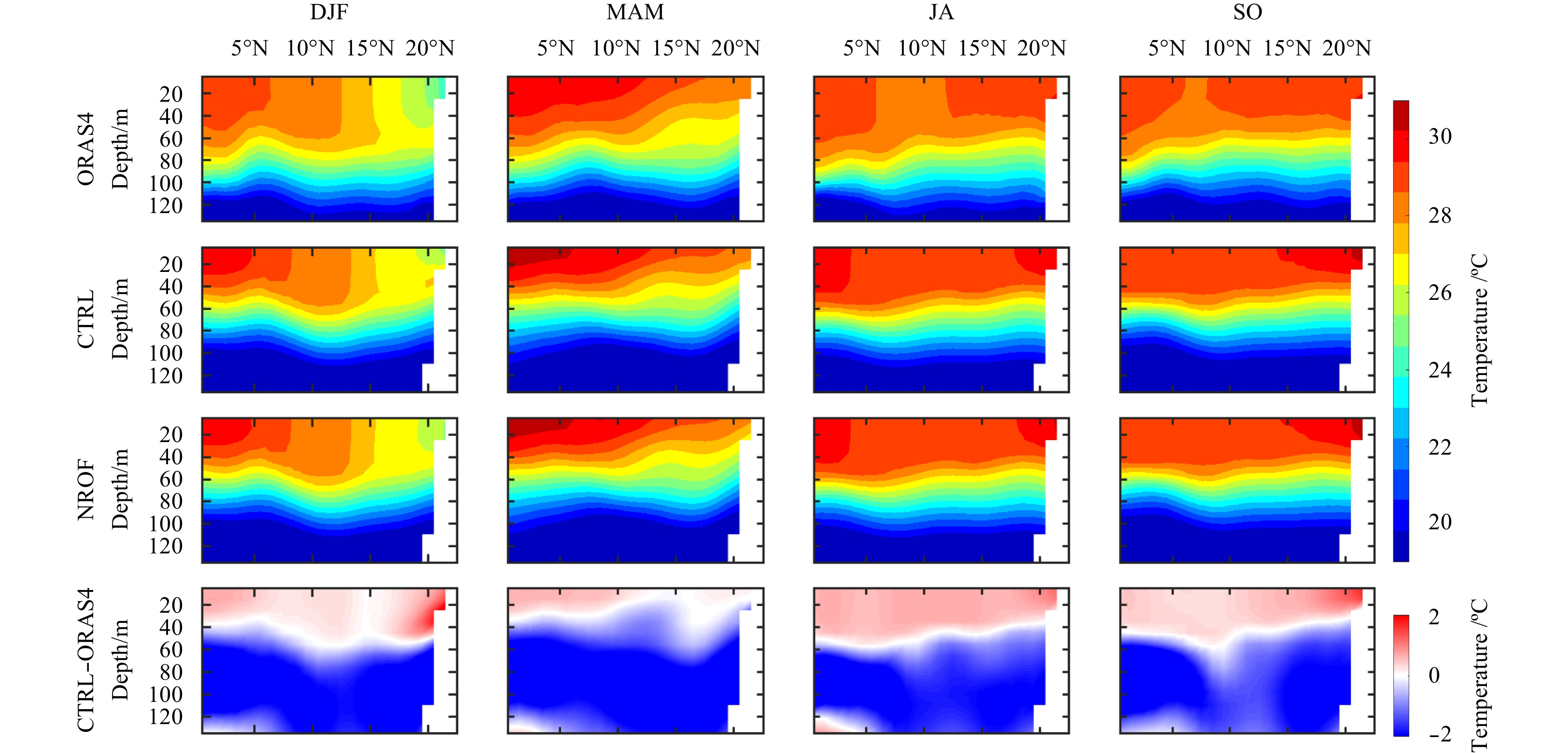
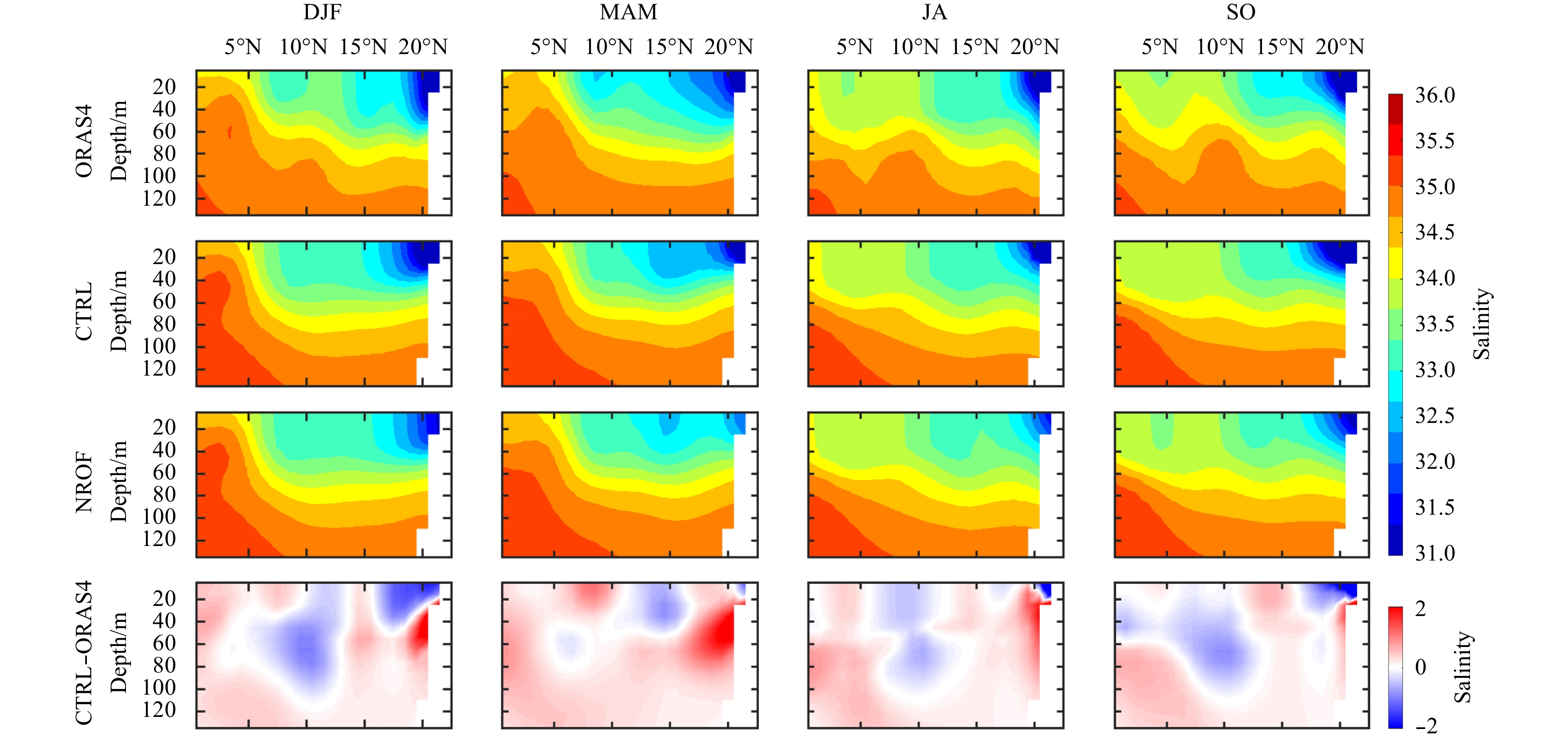
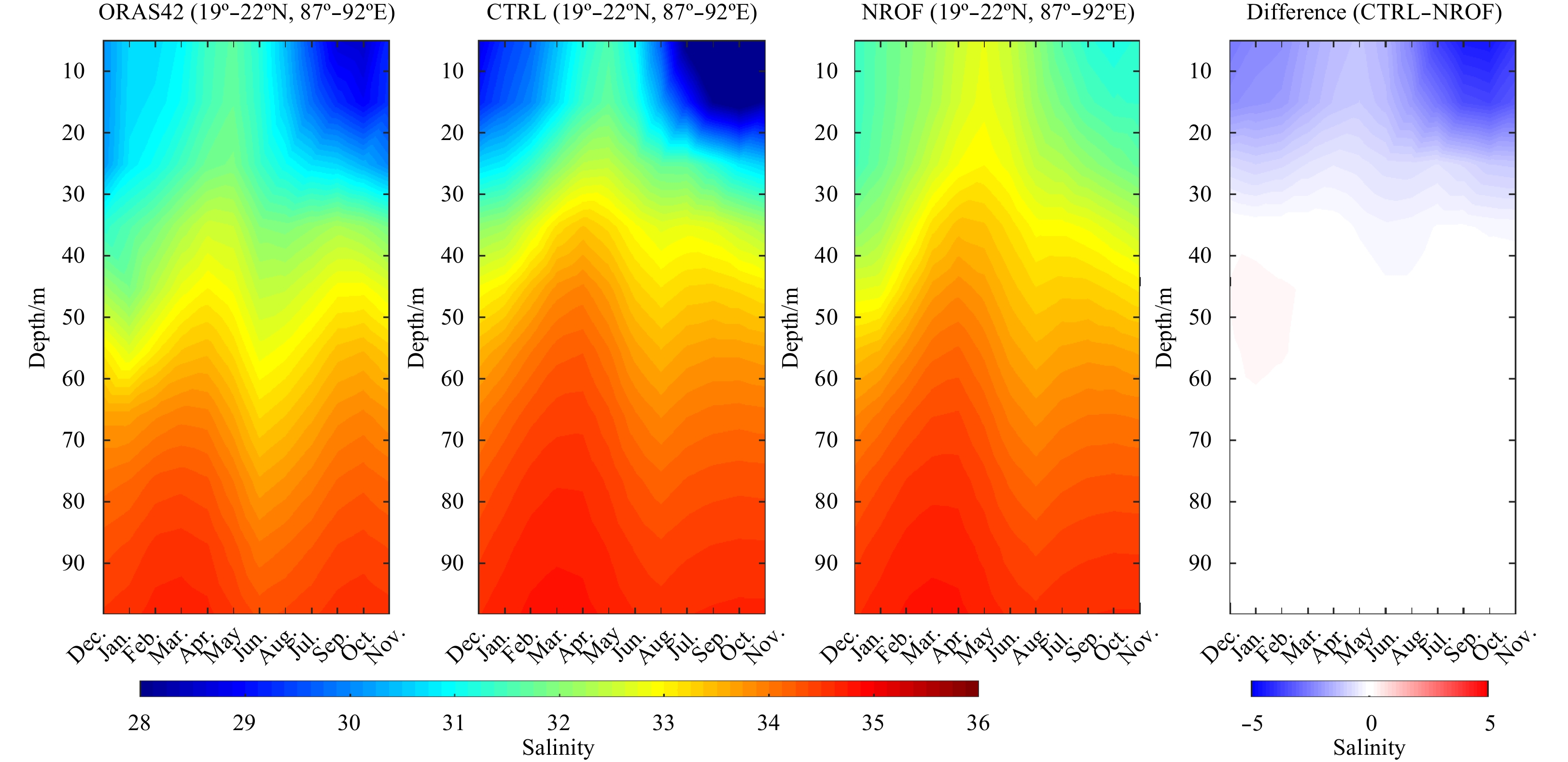
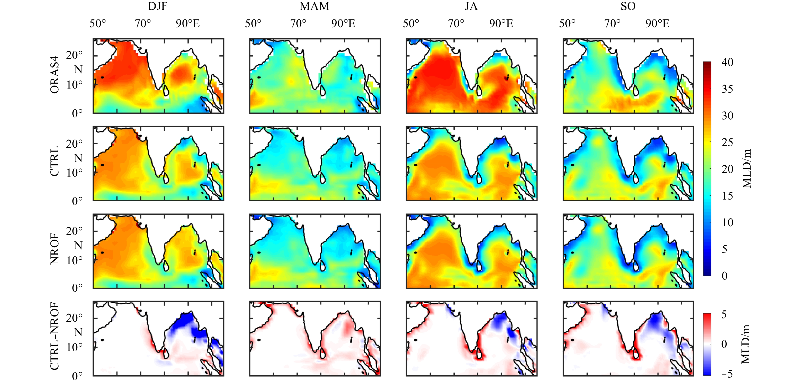
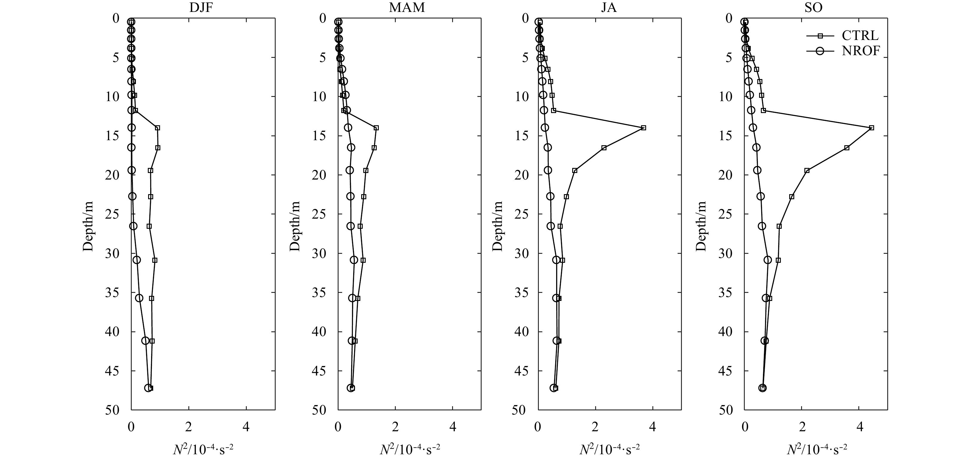
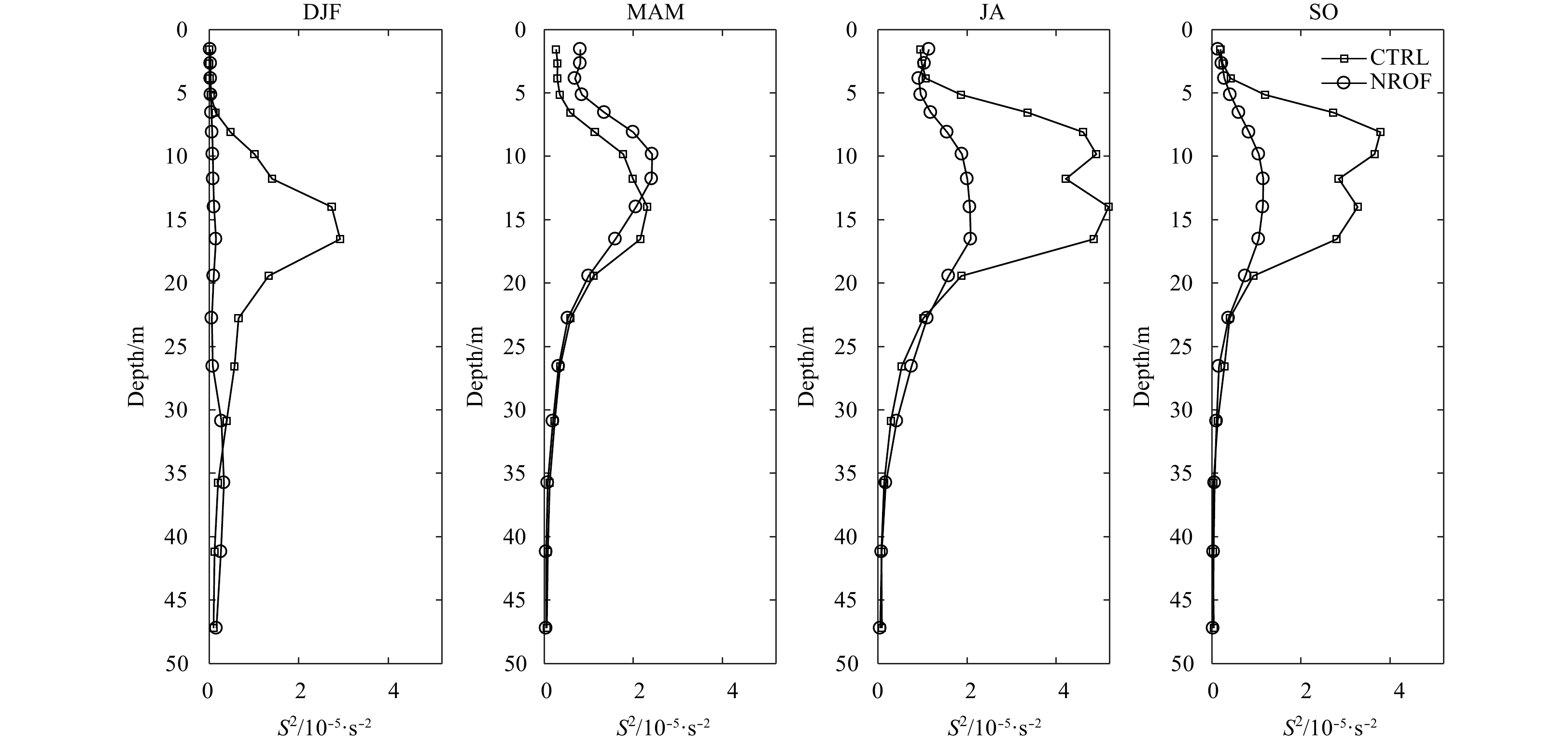
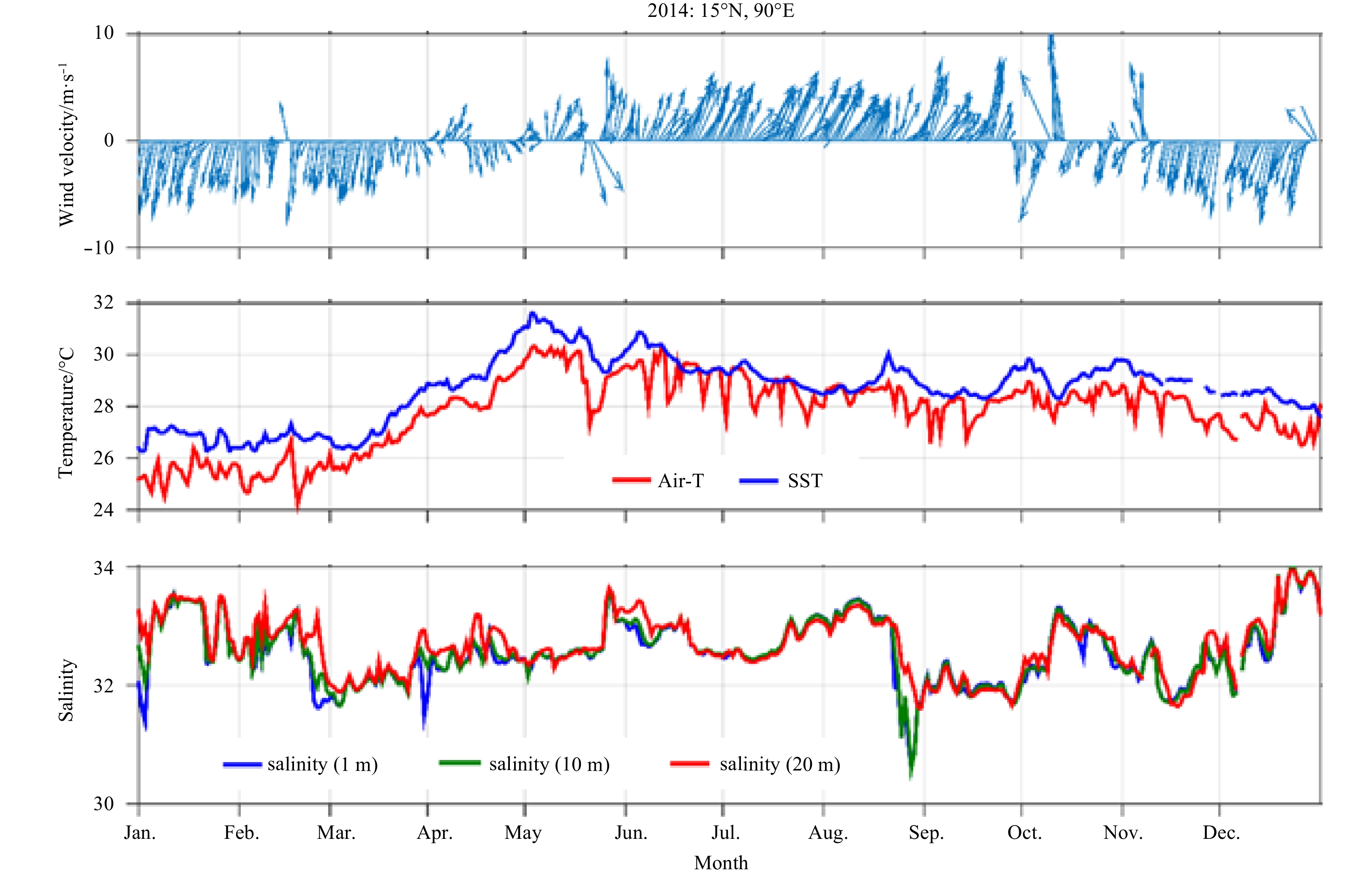
The effect of river runoff over the northern Indian Ocean (NIO) especially over the Bay of Bengal (BoB) has been studied using global Nucleus for European Modelling of the Ocean (NEMO). Two sensitivity experiments, with and without river runoff are conducted and the influence of river runoff on the Indian Ocean hydrography, stratification and circulation features are studied. It is found that due to river runoff surface salinity over the northern BoB decreases by more than 5 and the East India Coastal Current strengthens by 2 cm/s during post monsoon season. The fresh river water reaches up to 15°N in the BoB and is the main cause for low salinity there. Sea surface temperature in the northwestern BoB increases by more than 0.2°C due to the river runoff in summer monsoon while surface cooling upto 0.2°C is seen in north-west part of BoB in winter season. The seasonal mixed layer depth in the region is found to be dependent on river runoff. The effect of vertical shear and Brunt Vaisala frequency on stratification is also examined. The ocean water becomes highly stratified up to 3 035 m due to the river runoff. It is found that the energy required for mixing is high in the northern and coastal BoB.
The effect of river runoff over the northern Indian Ocean (NIO) especially over the Bay of Bengal (BoB) has been studied using global Nucleus for European Modelling of the Ocean (NEMO). Two sensitivity experiments, with and without river runoff are conducted and the influence of river runoff on the Indian Ocean hydrography, stratification and circulation features are studied. It is found that due to river runoff surface salinity over the northern BoB decreases by more than 5 and the East India Coastal Current strengthens by 2 cm/s during post monsoon season. The fresh river water reaches up to 15°N in the BoB and is the main cause for low salinity there. Sea surface temperature in the northwestern BoB increases by more than 0.2°C due to the river runoff in summer monsoon while surface cooling upto 0.2°C is seen in north-west part of BoB in winter season. The seasonal mixed layer depth in the region is found to be dependent on river runoff. The effect of vertical shear and Brunt Vaisala frequency on stratification is also examined. The ocean water becomes highly stratified up to 3 035 m due to the river runoff. It is found that the energy required for mixing is high in the northern and coastal BoB.


2020, 39(3): 56-62.
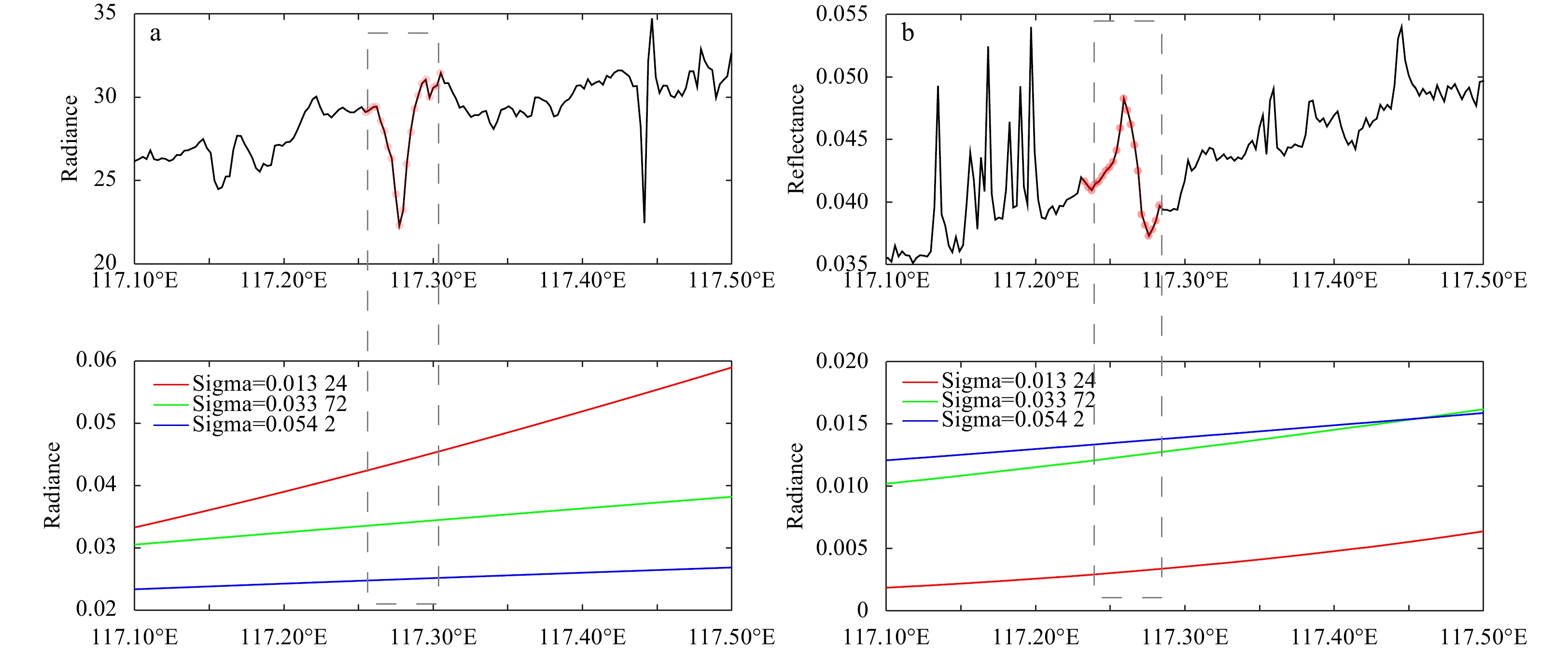
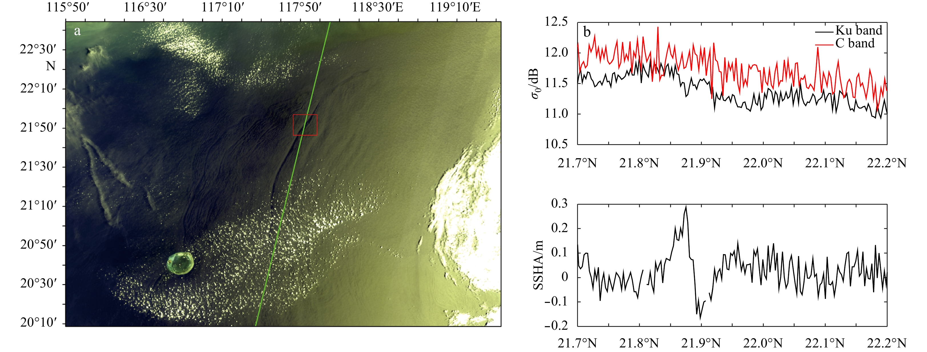
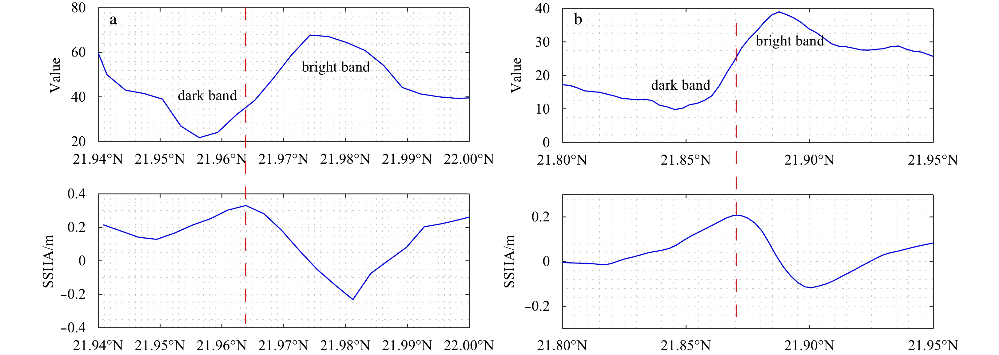
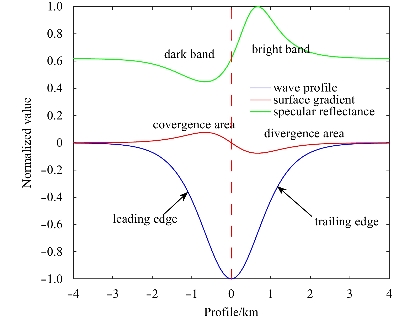
doi: 10.1007/s13131-019-1510-7
Abstract:
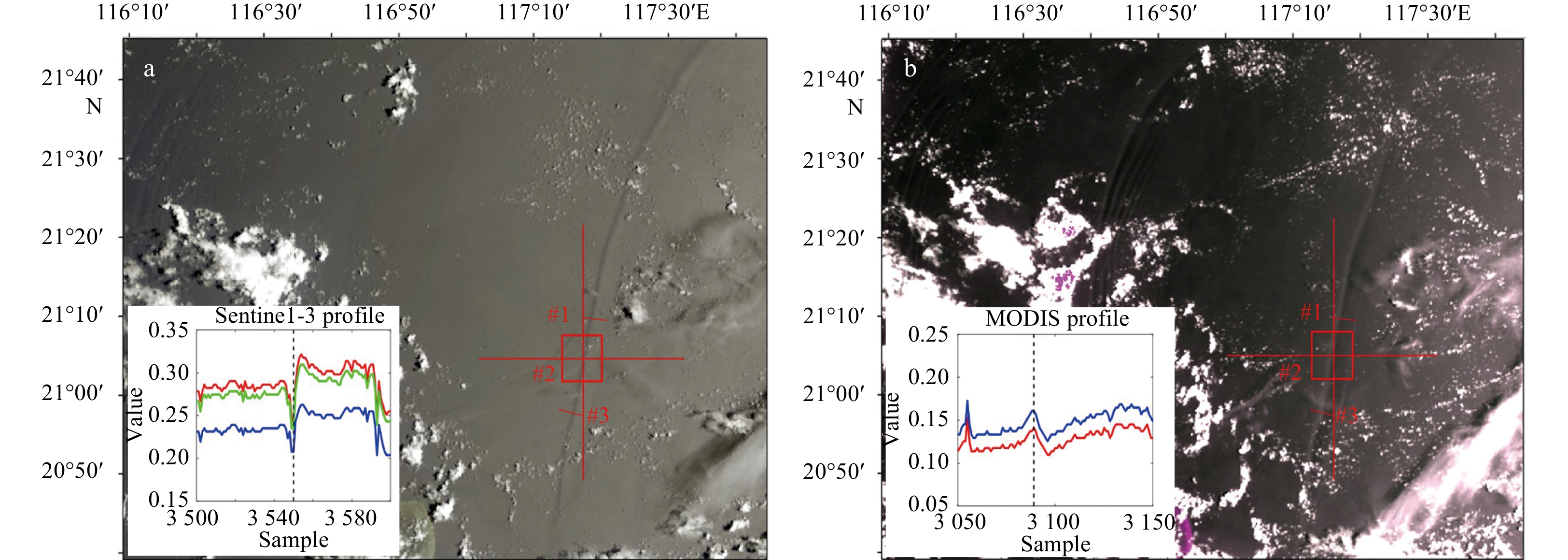
The ocean and land color instrument (OLCI) and synthetic aperture radar altimeter (SRAL) installed aboard the Sentinel-3 satellite have been in orbit for operational uses. In this study, data collected from Sentinel-3 are used to investigate internal waves in the South China Sea. An internal wave is detected using an OLCI image with a resolution of 300 m, and an analysis was performed with a quasi-synchronous moderate-resolution imaging spectroradiometer (MODIS) image. The opposite characteristics of OLCI and MODIS images of the same internal wave are explained by the critical angle in brightness reversals. The unique observational geometry of the OLCI image and its influence on observations of internal waves are discussed. The distribution of σ0 and sea surface height anomalies (SSHAs) induced by internal waves are studied using SRAL records. The σ0 records of SRAL occasionally show less sensitivity to the modulation of internal waves, which may be attributed to the observational geometry, while SSHAs show obvious variations. The synchronous pairing of OLCI images and SRAL records are analyzed to extract the three-dimensional sea surface signatures induced by internal waves. The analysis demonstrates that the profile of SSHAs in the surface shows an opposite phase to the profiles of internal waves in the ocean. The opposite phase relationship, observed in the remote sensing view, is also confirmed with a laboratory experiment.
The ocean and land color instrument (OLCI) and synthetic aperture radar altimeter (SRAL) installed aboard the Sentinel-3 satellite have been in orbit for operational uses. In this study, data collected from Sentinel-3 are used to investigate internal waves in the South China Sea. An internal wave is detected using an OLCI image with a resolution of 300 m, and an analysis was performed with a quasi-synchronous moderate-resolution imaging spectroradiometer (MODIS) image. The opposite characteristics of OLCI and MODIS images of the same internal wave are explained by the critical angle in brightness reversals. The unique observational geometry of the OLCI image and its influence on observations of internal waves are discussed. The distribution of σ0 and sea surface height anomalies (SSHAs) induced by internal waves are studied using SRAL records. The σ0 records of SRAL occasionally show less sensitivity to the modulation of internal waves, which may be attributed to the observational geometry, while SSHAs show obvious variations. The synchronous pairing of OLCI images and SRAL records are analyzed to extract the three-dimensional sea surface signatures induced by internal waves. The analysis demonstrates that the profile of SSHAs in the surface shows an opposite phase to the profiles of internal waves in the ocean. The opposite phase relationship, observed in the remote sensing view, is also confirmed with a laboratory experiment.


2020, 39(3): 63-72.
doi: 10.1007/s13131-020-1562-8
Abstract:
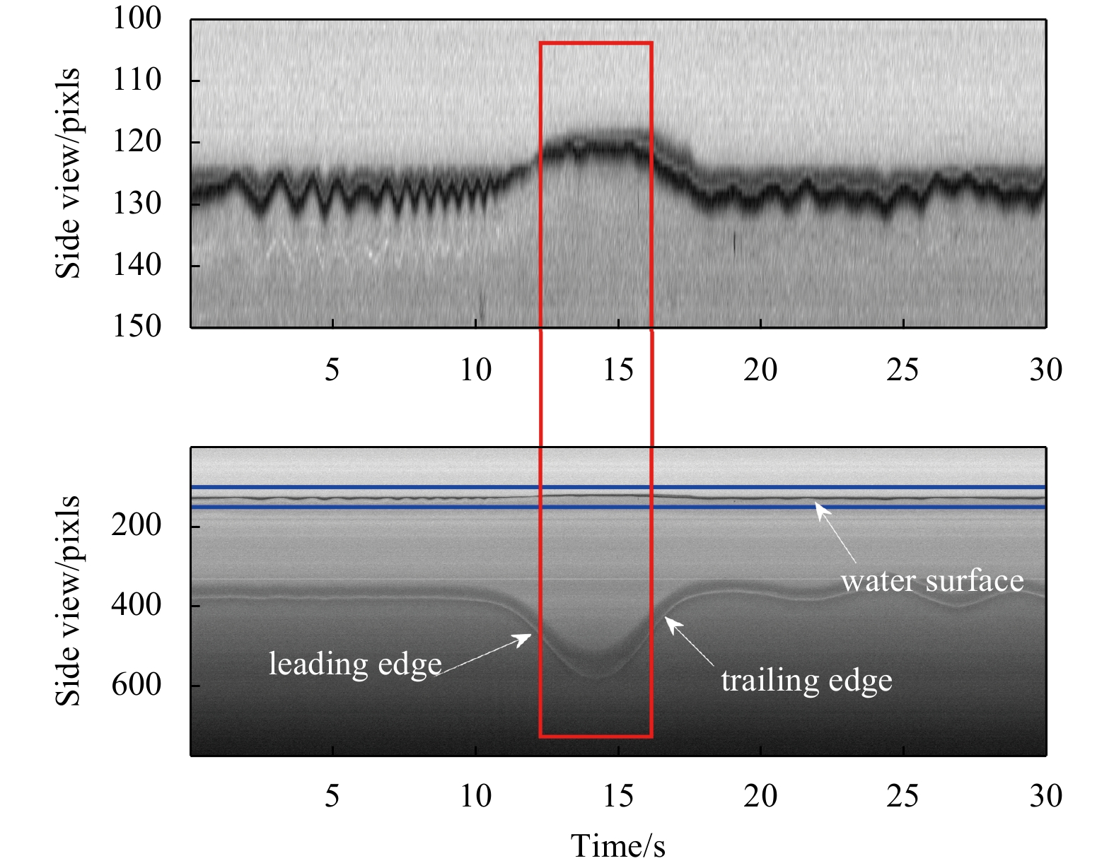
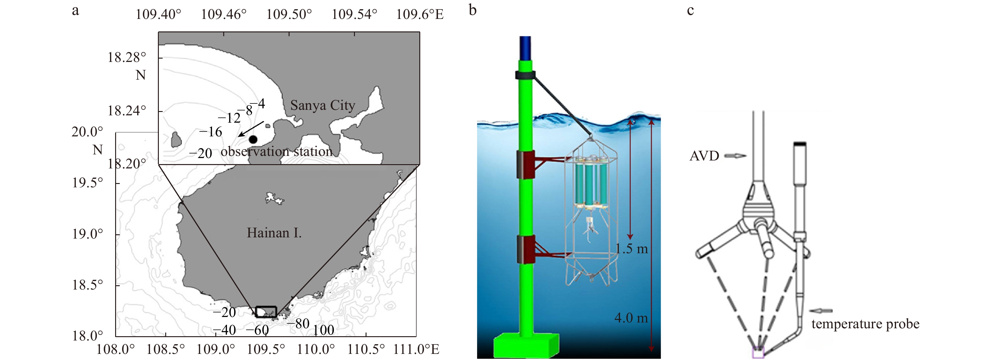
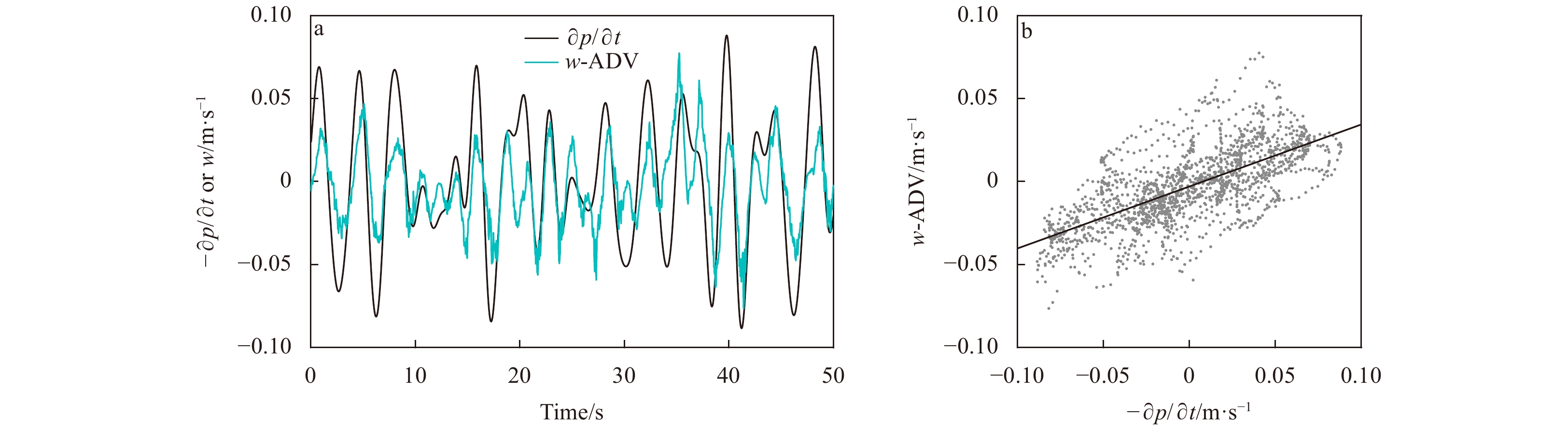
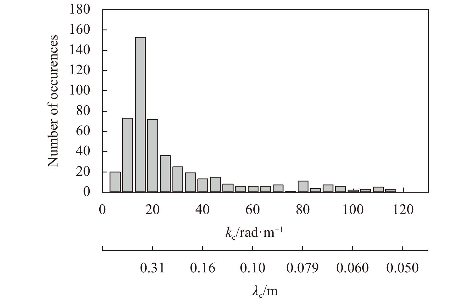
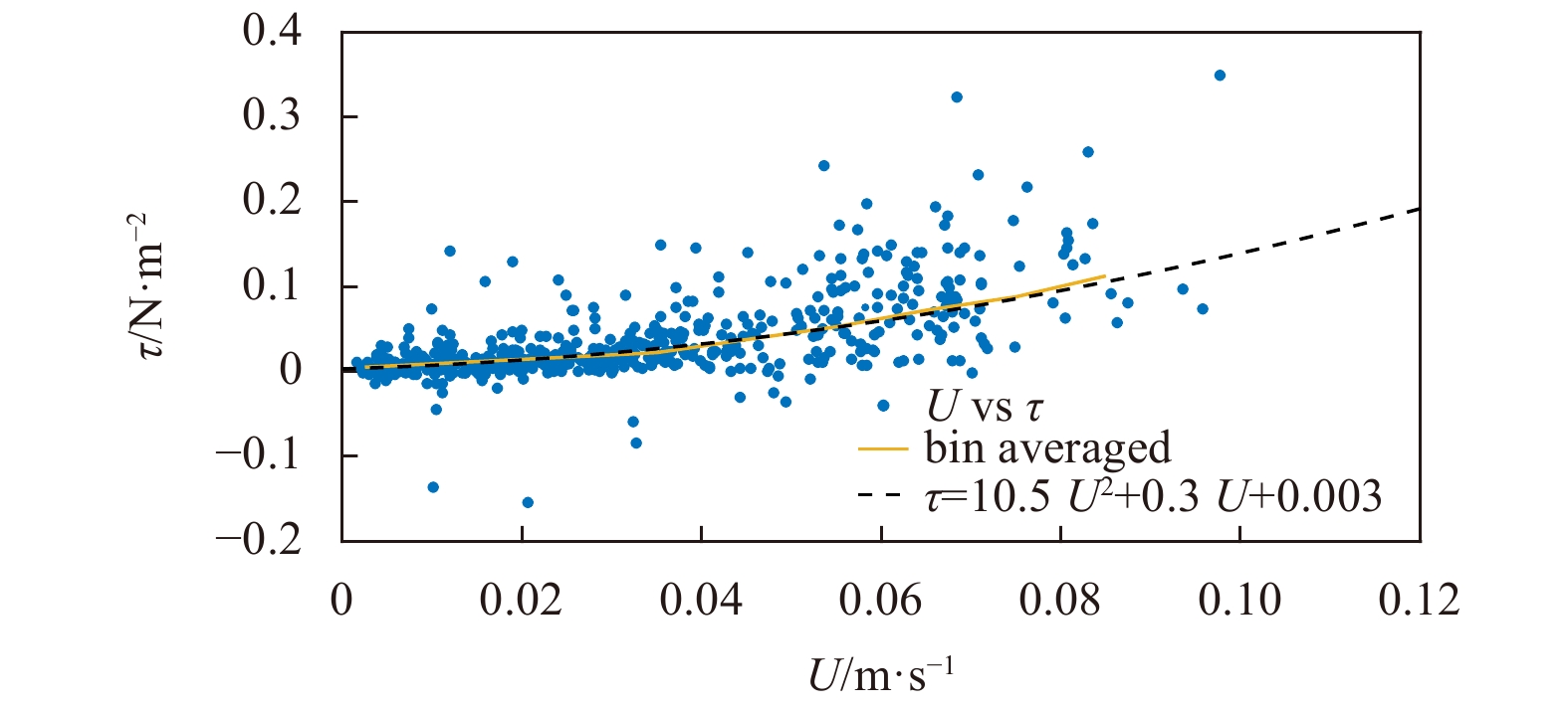
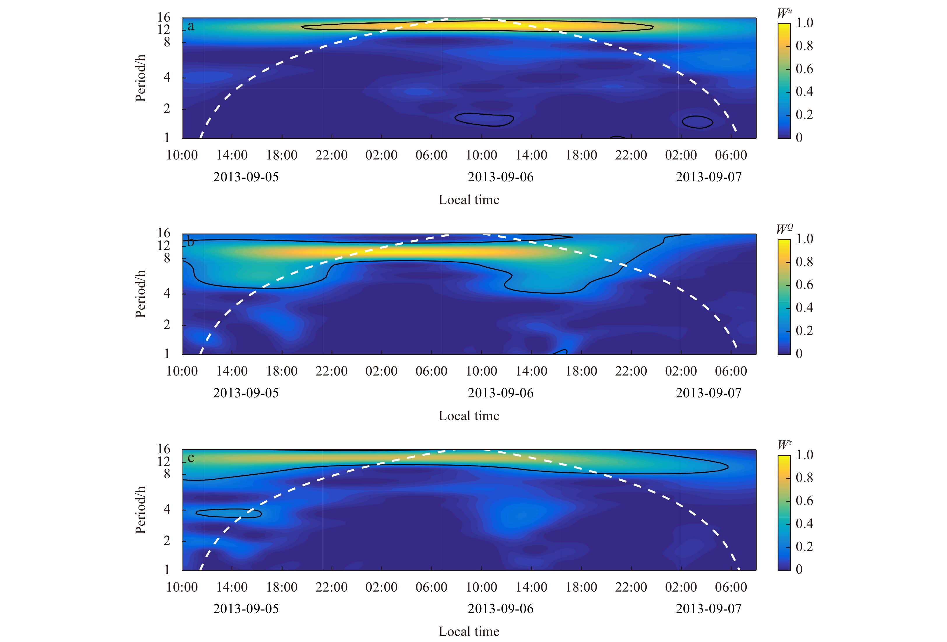
Turbulent eddies play a critical role in oceanic flows. Direct measurements of turbulent eddy fluxes beneath the sea surface were taken to study the direction of flux-carrying eddies as a means of supplementing our understanding of vertical fluxes exchange processes and their relationship to tides. The observations were made at 32 Hz at a water depth of ~1.5 m near the coast of Sanya, China, using an eddy covariance system, which mainly consists of an acoustic doppler velocimeter (ADV) and a fast temperature sensor. The cospectra-fit method—an established semi-empirical model of boundary layer turbulence to the measured turbulent cospectra at frequencies below those of surface gravity waves—was used in the presence of surface gravity waves to quantify the turbulent eddy fluxes (including turbulent heat flux and Reynolds stress). As much as 87% of the total turbulent stress and 88% of the total turbulent heat flux were determined as being at band frequencies below those of surface gravity waves. Both the turbulent heat flux and Reynolds stress showed a daily successive variation; the former peaked during the low tide period and the later peaked during the ebb tide period. Estimation of roll-off wavenumbers, k0, and roll-off wavelengths, λ0 (where λ0=2π/k0), which were estimated as the horizontal length scales of the dominant flux-carrying turbulent eddies, indicated that the λ0 of the turbulent heat flux was approximately double that of the Reynolds stress. Wavelet analysis showed that both the turbulent heat flux and the Reynolds stress have a close relationship to the semi-diurnal and diurnal tides, and therefore indicate the energy that is transported from tides to turbulence.
Turbulent eddies play a critical role in oceanic flows. Direct measurements of turbulent eddy fluxes beneath the sea surface were taken to study the direction of flux-carrying eddies as a means of supplementing our understanding of vertical fluxes exchange processes and their relationship to tides. The observations were made at 32 Hz at a water depth of ~1.5 m near the coast of Sanya, China, using an eddy covariance system, which mainly consists of an acoustic doppler velocimeter (ADV) and a fast temperature sensor. The cospectra-fit method—an established semi-empirical model of boundary layer turbulence to the measured turbulent cospectra at frequencies below those of surface gravity waves—was used in the presence of surface gravity waves to quantify the turbulent eddy fluxes (including turbulent heat flux and Reynolds stress). As much as 87% of the total turbulent stress and 88% of the total turbulent heat flux were determined as being at band frequencies below those of surface gravity waves. Both the turbulent heat flux and Reynolds stress showed a daily successive variation; the former peaked during the low tide period and the later peaked during the ebb tide period. Estimation of roll-off wavenumbers, k0, and roll-off wavelengths, λ0 (where λ0=2π/k0), which were estimated as the horizontal length scales of the dominant flux-carrying turbulent eddies, indicated that the λ0 of the turbulent heat flux was approximately double that of the Reynolds stress. Wavelet analysis showed that both the turbulent heat flux and the Reynolds stress have a close relationship to the semi-diurnal and diurnal tides, and therefore indicate the energy that is transported from tides to turbulence.


2020, 39(3): 73-80.
doi: 10.1007/s13131-020-1568-2
Abstract:
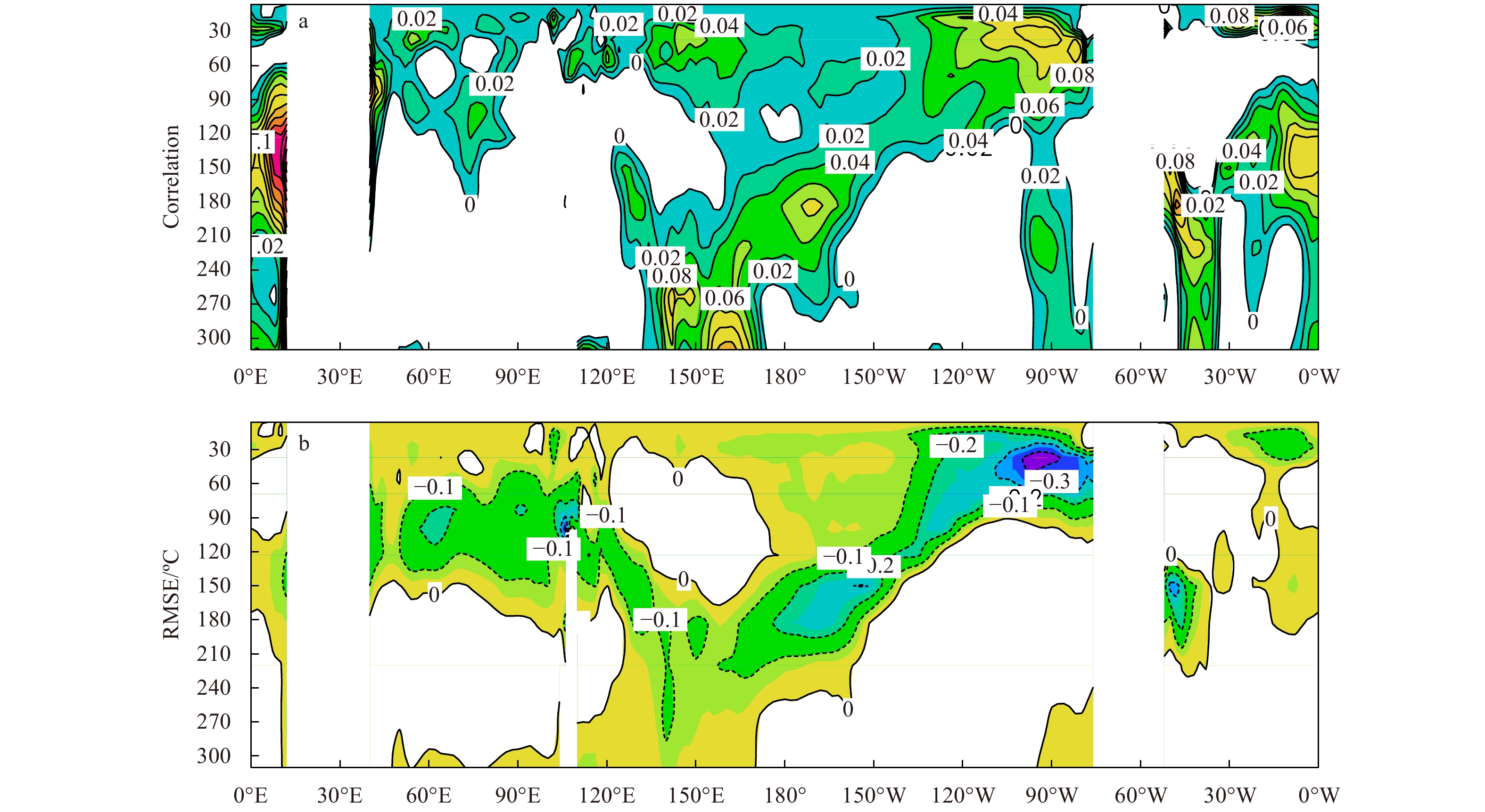
An ensemble-based assimilation method is proposed for correcting the subsurface temperature field when nudging the sea surface temperature (SST) observations into the Max Planck Institute (MPI) climate model, ECHAM5/MPI-OM. This method can project SST directly to subsurface according to model ensemble-based correlations between SST and subsurface temperature. Results from a 50 year (1960–2009) assimilation experiment show the method can improve the subsurface temperature field up to 300 m compared to the quality-controlled subsurface ocean temperature objective analyses (EN4), through reducing the biases of the thermal states, improving the thermocline structure, and reducing the root mean square (RMS) errors. Moreover, as most of the improvements concentrate over the upper 100 m, the ocean heat content in the upper 100 m (OHT_100 m) is further adopted as a property to validate the performance of the ensemble-based correction method. The results show that RMS errors of the global OHT_100 m convergent to one value after several times iteration, indicating this method can represent the relationship between SST and subsurface temperature fields well, and then improve the accuracy of the simulation in the subsurface temperature of the climate model.
An ensemble-based assimilation method is proposed for correcting the subsurface temperature field when nudging the sea surface temperature (SST) observations into the Max Planck Institute (MPI) climate model, ECHAM5/MPI-OM. This method can project SST directly to subsurface according to model ensemble-based correlations between SST and subsurface temperature. Results from a 50 year (1960–2009) assimilation experiment show the method can improve the subsurface temperature field up to 300 m compared to the quality-controlled subsurface ocean temperature objective analyses (EN4), through reducing the biases of the thermal states, improving the thermocline structure, and reducing the root mean square (RMS) errors. Moreover, as most of the improvements concentrate over the upper 100 m, the ocean heat content in the upper 100 m (OHT_100 m) is further adopted as a property to validate the performance of the ensemble-based correction method. The results show that RMS errors of the global OHT_100 m convergent to one value after several times iteration, indicating this method can represent the relationship between SST and subsurface temperature fields well, and then improve the accuracy of the simulation in the subsurface temperature of the climate model.


2020, 39(3): 81-89.
doi: 10.1007/s13131-019-1531-2
Abstract:
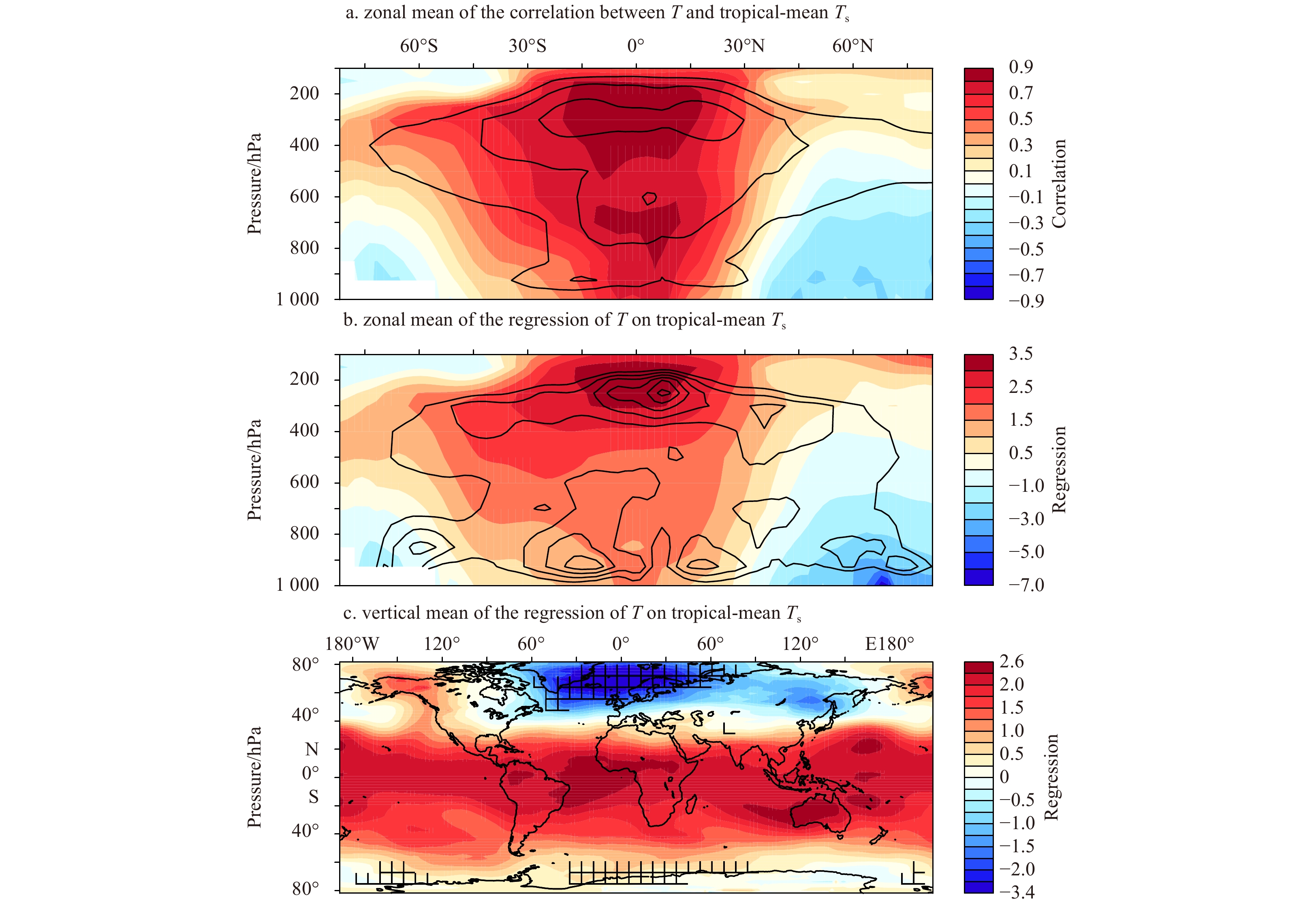
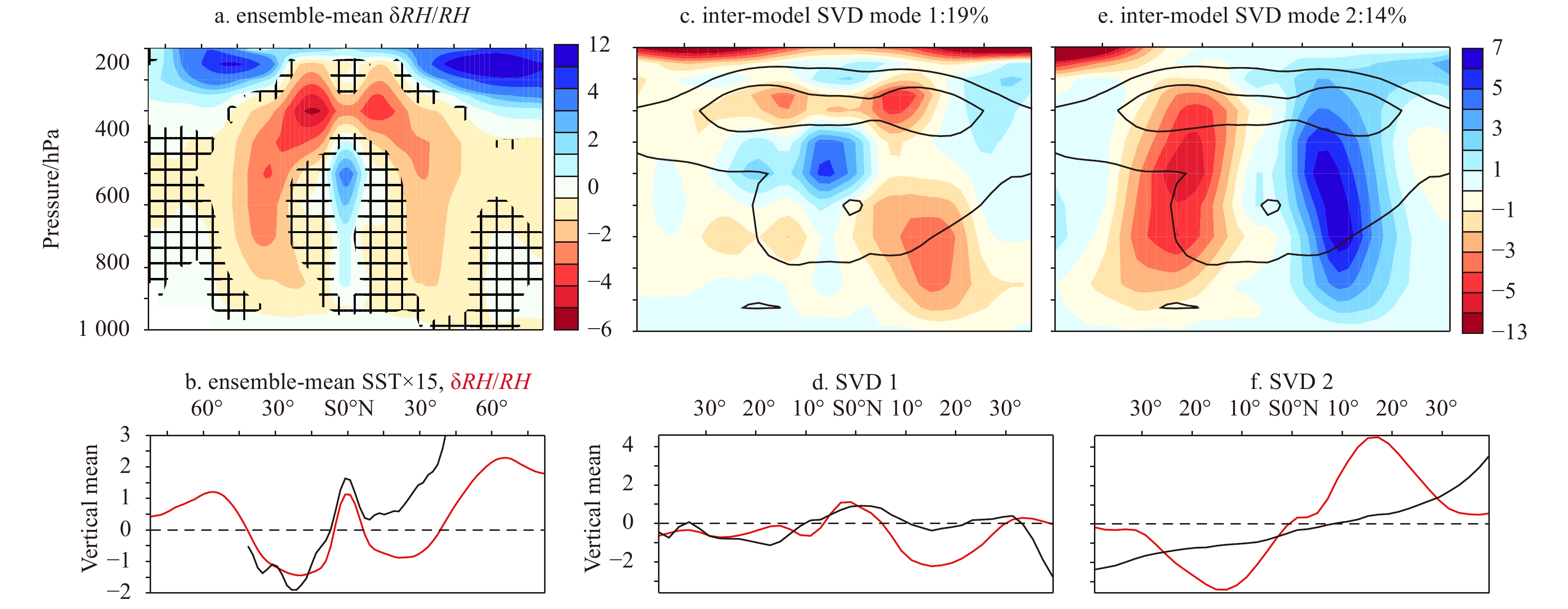
Climate feedbacks have been usually estimated using changes in radiative effects associated with increased global-mean surface temperature. Feedback uncertainties, however, are not only functions of global-mean surface temperature increase. In projections by global climate models, it has been demonstrated that the geographical variation of sea surface temperature change brings significant uncertainties into atmospheric circulation and precipitation responses at regional scales. Here we show that the spatial pattern of surface warming is a major contributor to uncertainty in the combined water vapour-lapse rate feedback. This is demonstrated by computing the global-mean radiative effects of changes in air temperature and relative humidity simulated by 31 climate models using a methodology based on radiative kernels. Our results highlight the important contribution of regional climate change to the uncertainty in climate feedbacks, and identify the regions of the world where constraining surface warming patterns would be most effective for higher skill of climate projections.
Climate feedbacks have been usually estimated using changes in radiative effects associated with increased global-mean surface temperature. Feedback uncertainties, however, are not only functions of global-mean surface temperature increase. In projections by global climate models, it has been demonstrated that the geographical variation of sea surface temperature change brings significant uncertainties into atmospheric circulation and precipitation responses at regional scales. Here we show that the spatial pattern of surface warming is a major contributor to uncertainty in the combined water vapour-lapse rate feedback. This is demonstrated by computing the global-mean radiative effects of changes in air temperature and relative humidity simulated by 31 climate models using a methodology based on radiative kernels. Our results highlight the important contribution of regional climate change to the uncertainty in climate feedbacks, and identify the regions of the world where constraining surface warming patterns would be most effective for higher skill of climate projections.


2020, 39(3): 90-102.
doi: 10.1007/s13131-020-1558-4
Abstract:
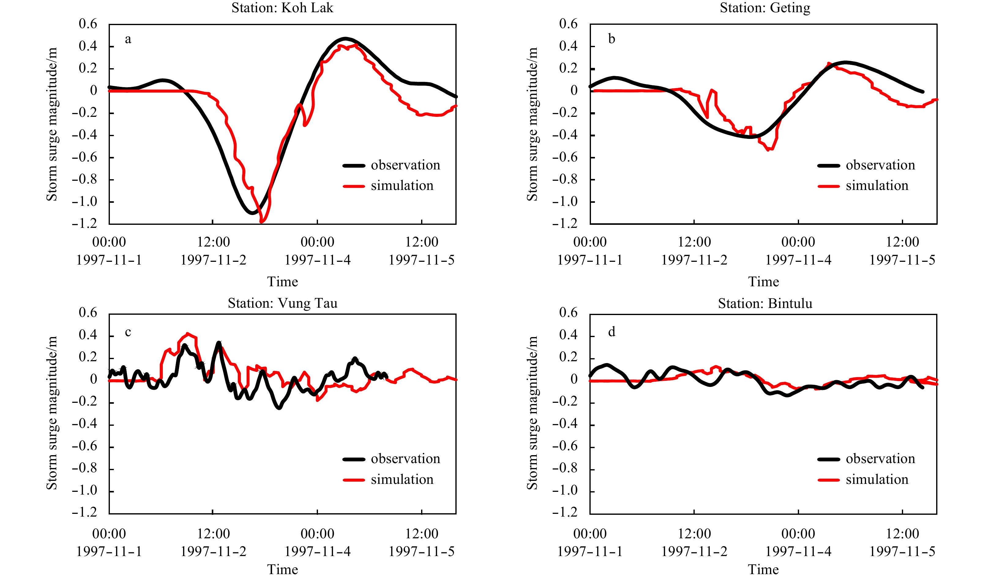
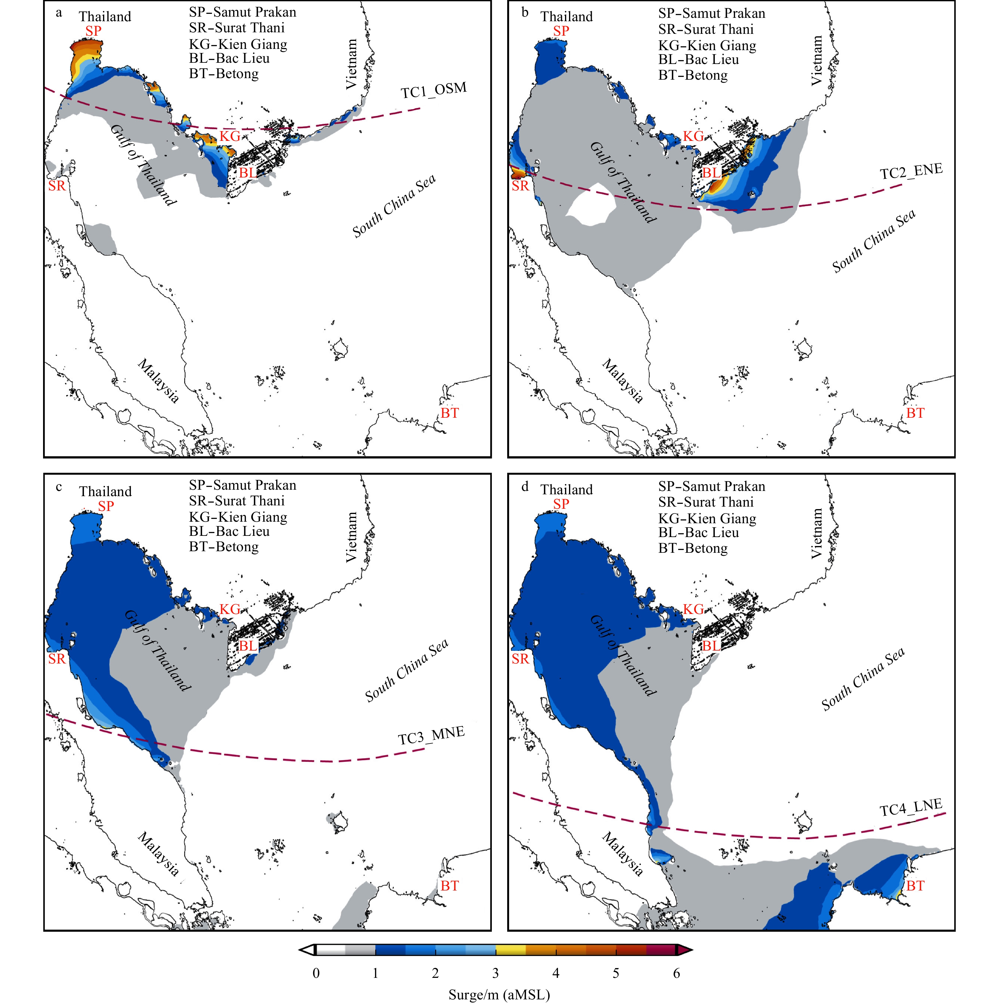
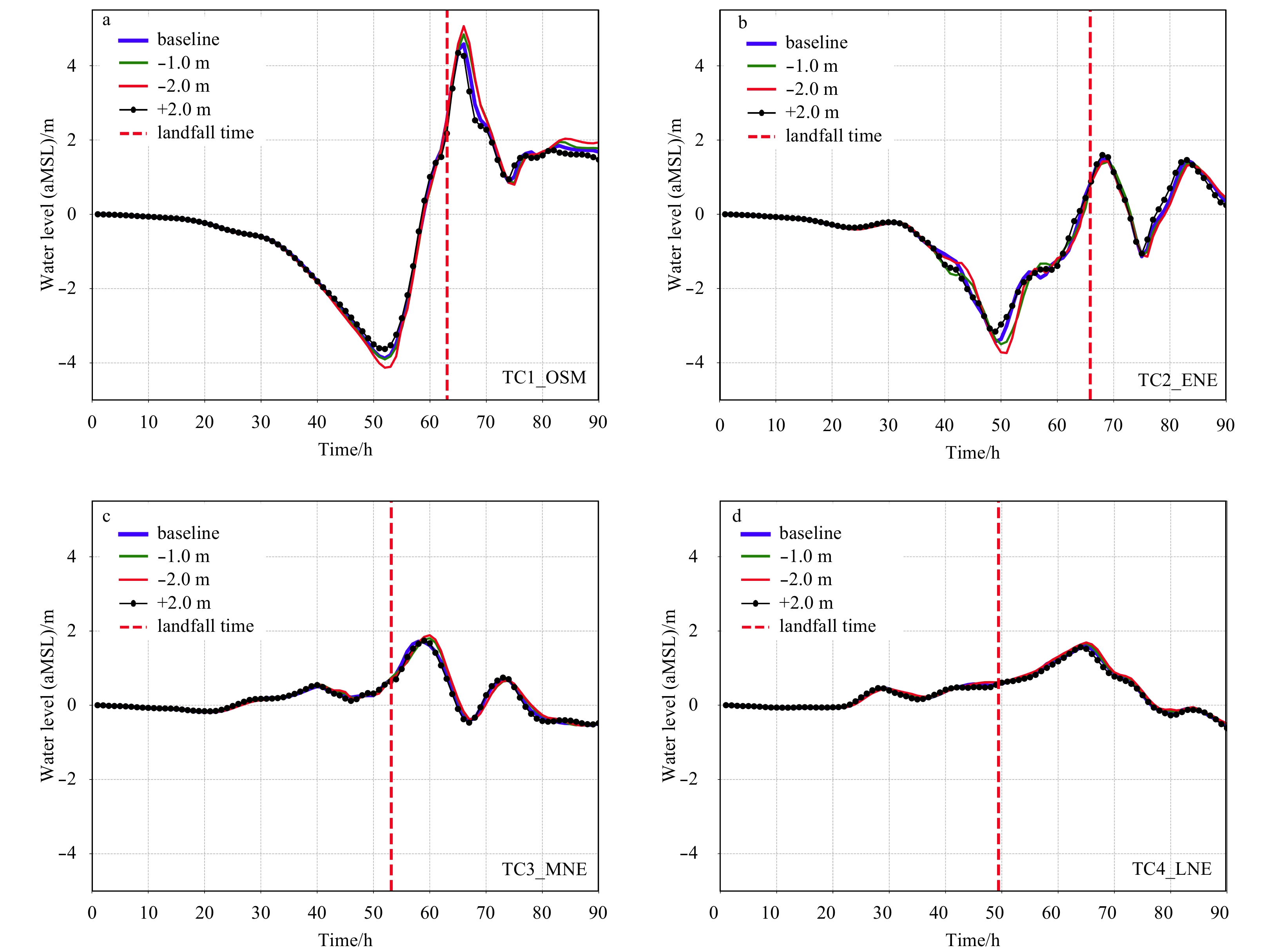
The influences of tropical cyclone paths and shelf bathymetry on the inducement of extreme sea levels in a regional bay are investigated. A finite volume coastal ocean model (FVCOM) has been configured for the Gulf of Thailand-Sunda Shelf. A parametric wind model is used to drive the FVCOM. The contributions of the tropical cyclone characteristics are determined through a scenario-based study. Validation based on a historical extreme sea level event shows that the model can resolve the oscillation mechanism well. The intensification of severe storm surges in the region highly depends on four factors including phase propagation of the storm surge wave determined by the landfall position, funnel effect caused by locality of the coastline, and shelf bathymetry determined by the state of mean sea level and coastline crossing angle of the storm path. The coexistence of these factors can cause particular regions e.g. the Surat Thani Bay, inner Gulf of Thailand and Ca Mau Peninsular to experience a larger surge magnitude. These areas are found to be highly related to monsoon troughs that develop during the onset and early northeastern monsoon season (October–November).
The influences of tropical cyclone paths and shelf bathymetry on the inducement of extreme sea levels in a regional bay are investigated. A finite volume coastal ocean model (FVCOM) has been configured for the Gulf of Thailand-Sunda Shelf. A parametric wind model is used to drive the FVCOM. The contributions of the tropical cyclone characteristics are determined through a scenario-based study. Validation based on a historical extreme sea level event shows that the model can resolve the oscillation mechanism well. The intensification of severe storm surges in the region highly depends on four factors including phase propagation of the storm surge wave determined by the landfall position, funnel effect caused by locality of the coastline, and shelf bathymetry determined by the state of mean sea level and coastline crossing angle of the storm path. The coexistence of these factors can cause particular regions e.g. the Surat Thani Bay, inner Gulf of Thailand and Ca Mau Peninsular to experience a larger surge magnitude. These areas are found to be highly related to monsoon troughs that develop during the onset and early northeastern monsoon season (October–November).


2020, 39(3): 103-112.
doi: 10.1007/s13131-020-1557-5
Abstract:
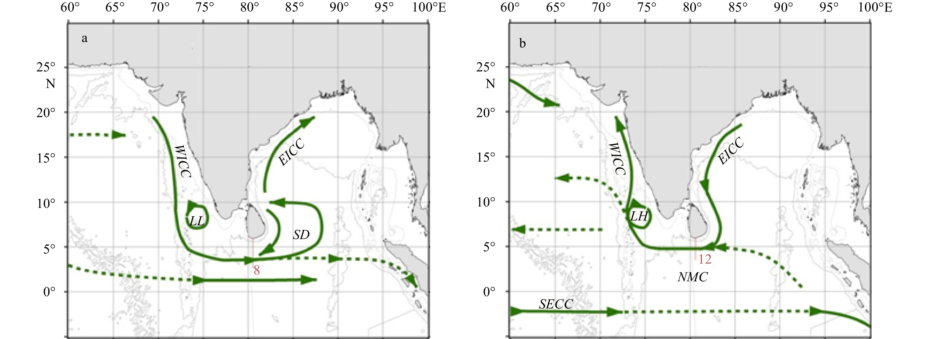
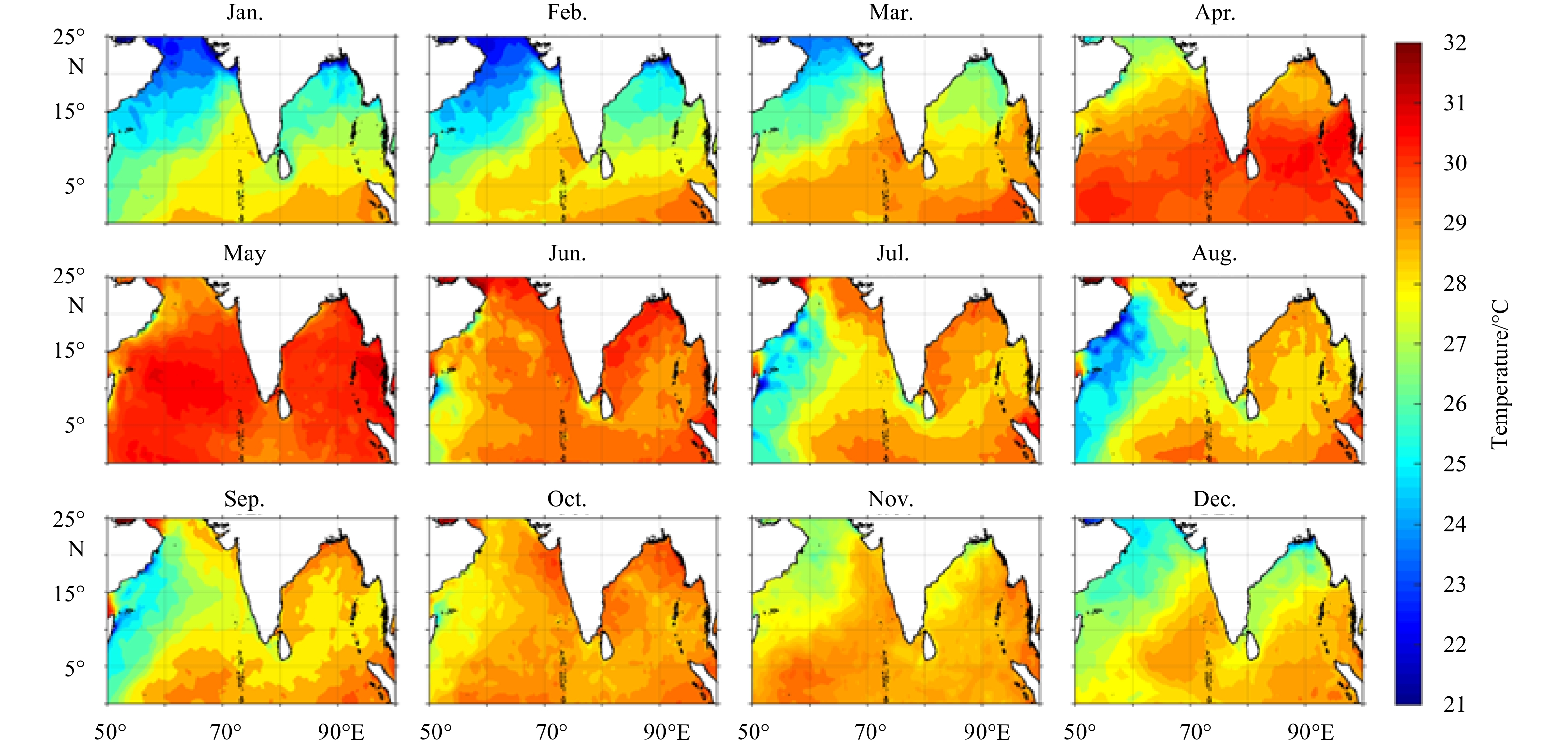
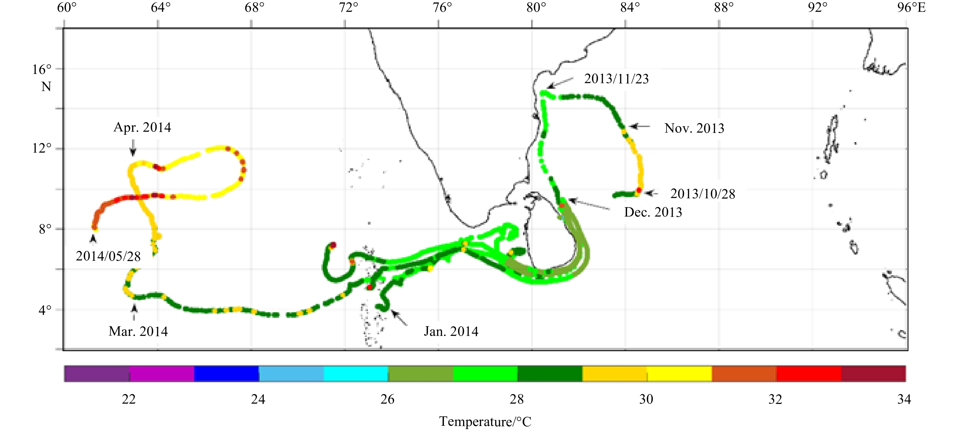
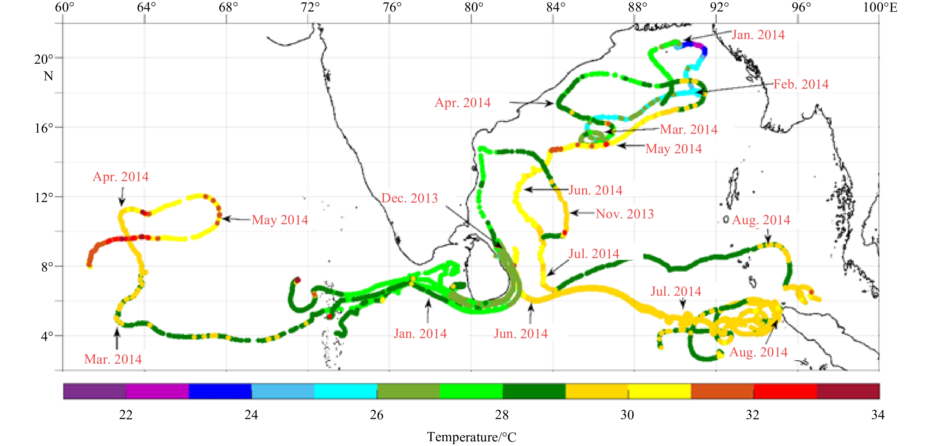
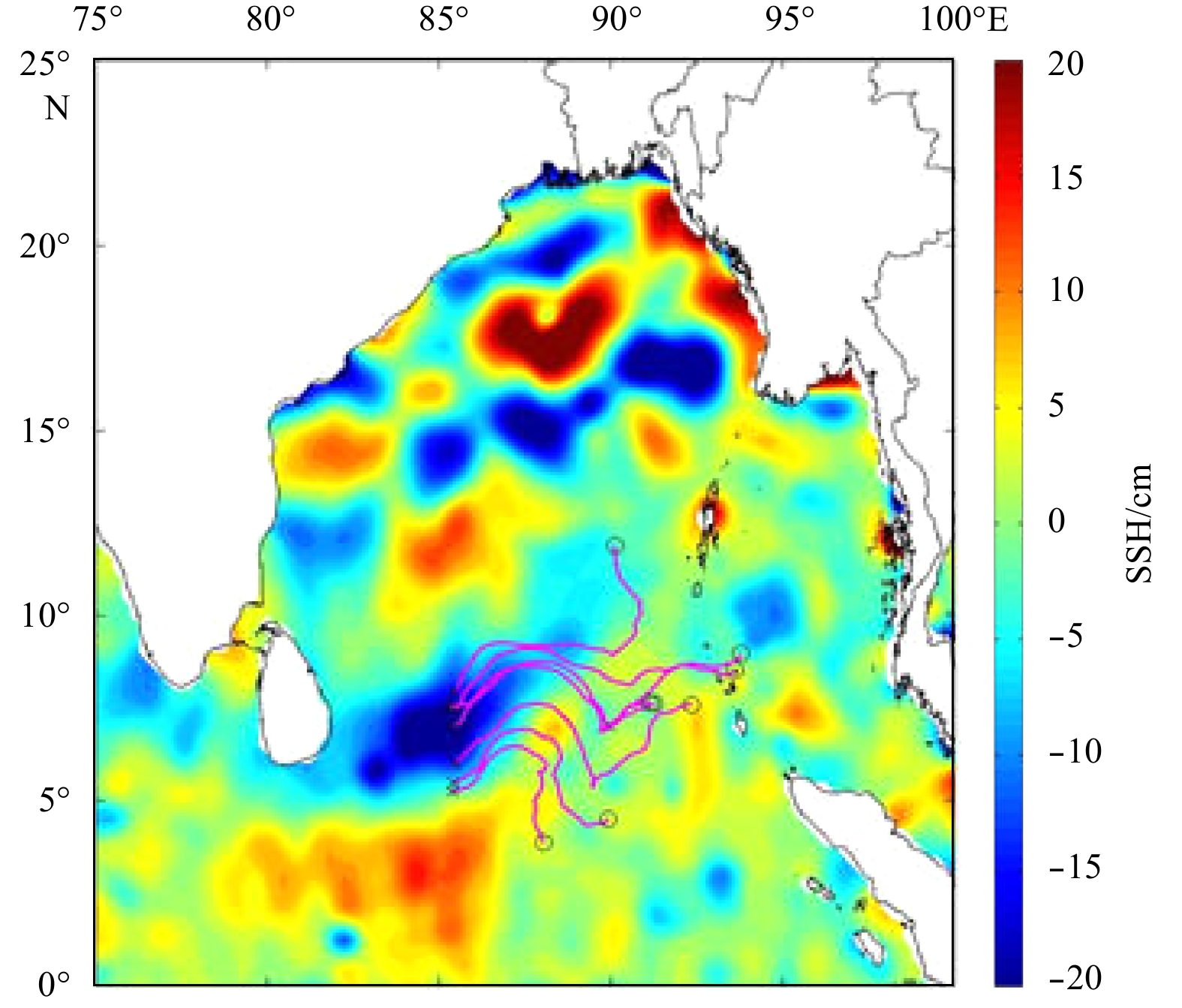
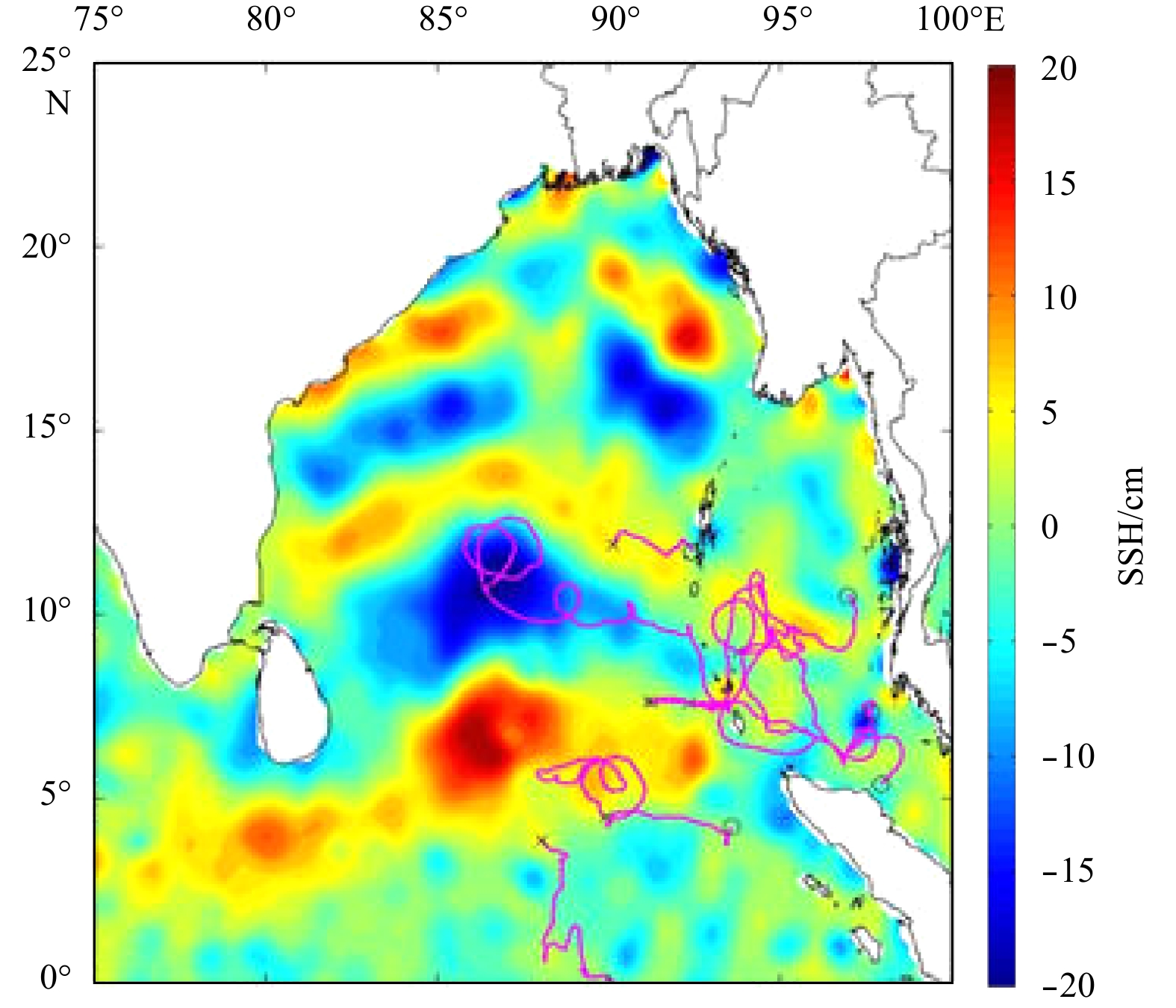
Monsoon driven water mass exchange between the Bay of Bengal (BoB) and Arabian Sea (AS) is the common experience. However, it is not yet firmly confirmed that the exchange pathway is either passing through southern tip of Sri Lanka or Palk Strait. Local circulation patterns impact the pathways followed by the East Indian Coastal Currents (EICC) that drive exchange, thereby modulating mixing and water mass transformation in the Bay of Bengal around Sri Lanka. In this study, observations from surface drifters were incorporated with the satellite derived data to understand the monsoonal impact on circulation patterns in the Indian Ocean. This was the first multi-national scientific effort which was conducted in the BoB and AS during 2013 to 2015 to understand the monsoonal impact on circulation patterns in the complex region. The results indicated that seasonally reversing monsoonal currents of southern Sri Lanka, traced by the wintertime freshwater export pathways of the EICC. The deflection of monsoon currents running along the east coast of Sri Lanka by forming cyclonic and anti-cyclonic eddies, which influence the mixing and stirring associated with these flows. Results further indicate the low salinity cold water flows from the BoB to AS along the western boundary of the BoB during northeast monsoon. In the same way, reverses the phenomena during southwest monsoon, transporting high salinity warm water from AS to the BoB. This maintain the bay status which occurred due to freshwater influx from large rivers and high saline water from AS. However, no evidences were observed for the exchange through Palk Strait during the study. Also, there are some mis-matches in in-situ and remotely sensed measurements which imply the necessity of systematic observation system for the complex region as an alternative approach.
Monsoon driven water mass exchange between the Bay of Bengal (BoB) and Arabian Sea (AS) is the common experience. However, it is not yet firmly confirmed that the exchange pathway is either passing through southern tip of Sri Lanka or Palk Strait. Local circulation patterns impact the pathways followed by the East Indian Coastal Currents (EICC) that drive exchange, thereby modulating mixing and water mass transformation in the Bay of Bengal around Sri Lanka. In this study, observations from surface drifters were incorporated with the satellite derived data to understand the monsoonal impact on circulation patterns in the Indian Ocean. This was the first multi-national scientific effort which was conducted in the BoB and AS during 2013 to 2015 to understand the monsoonal impact on circulation patterns in the complex region. The results indicated that seasonally reversing monsoonal currents of southern Sri Lanka, traced by the wintertime freshwater export pathways of the EICC. The deflection of monsoon currents running along the east coast of Sri Lanka by forming cyclonic and anti-cyclonic eddies, which influence the mixing and stirring associated with these flows. Results further indicate the low salinity cold water flows from the BoB to AS along the western boundary of the BoB during northeast monsoon. In the same way, reverses the phenomena during southwest monsoon, transporting high salinity warm water from AS to the BoB. This maintain the bay status which occurred due to freshwater influx from large rivers and high saline water from AS. However, no evidences were observed for the exchange through Palk Strait during the study. Also, there are some mis-matches in in-situ and remotely sensed measurements which imply the necessity of systematic observation system for the complex region as an alternative approach.


2020, 39(3): 113-122.
doi: 10.1007/s13131-020-1539-7
Abstract:
Sea-surface acoustic backscattering measurements at moderate to high frequencies were performed in the shallow water of the south Yellow Sea, using omnidirectional spherical sources and omnidirectional hydrophones. Sea-surface backscattering data for frequencies in the 6–25 kHz range and wind speeds of (3.0±0.5) and (4.5±1.0) m/s were obtained from two adjacent experimental sites, respectively. Computation of sea-surface backscattering strength using bistatic transducer is described. Finally, we calculated sea-surface backscattering strengths at grazing angles in the range of 16°–85°. We find that the measured backscattering strengths agree reasonably well with those predicted by using second order small-roughness perturbation approximation method with “PM” roughness spectrum for all frequencies at grazing angles ranged from 40° to 80°. The backscattering strengths varied slightly at grazing angles of 16°–40°, and were much stronger than roughness scattering. It is speculated that scattering from bubbles dominates the backscattering strengths at high wind speeds and small grazing angles. At the same frequencies and moderate to high grazing angles, the results show that the backscattering strengths at a wind speed of (4.5±1.0) m/s were approximately 5 dB higher than those at a wind speed of (3.0±0.5) m/s. However, the discrepancies of backscattering strength at low grazing angles were more than 10 dB. Furthermore the backscattering strengths exhibited no significant frequency dependence at 3 m/s wind speed. At a wind speed of 4.5 m/s, the scattering strengths increased at low grazing angles but decreased at high grazing angles with increasing grazing angle.
Sea-surface acoustic backscattering measurements at moderate to high frequencies were performed in the shallow water of the south Yellow Sea, using omnidirectional spherical sources and omnidirectional hydrophones. Sea-surface backscattering data for frequencies in the 6–25 kHz range and wind speeds of (3.0±0.5) and (4.5±1.0) m/s were obtained from two adjacent experimental sites, respectively. Computation of sea-surface backscattering strength using bistatic transducer is described. Finally, we calculated sea-surface backscattering strengths at grazing angles in the range of 16°–85°. We find that the measured backscattering strengths agree reasonably well with those predicted by using second order small-roughness perturbation approximation method with “PM” roughness spectrum for all frequencies at grazing angles ranged from 40° to 80°. The backscattering strengths varied slightly at grazing angles of 16°–40°, and were much stronger than roughness scattering. It is speculated that scattering from bubbles dominates the backscattering strengths at high wind speeds and small grazing angles. At the same frequencies and moderate to high grazing angles, the results show that the backscattering strengths at a wind speed of (4.5±1.0) m/s were approximately 5 dB higher than those at a wind speed of (3.0±0.5) m/s. However, the discrepancies of backscattering strength at low grazing angles were more than 10 dB. Furthermore the backscattering strengths exhibited no significant frequency dependence at 3 m/s wind speed. At a wind speed of 4.5 m/s, the scattering strengths increased at low grazing angles but decreased at high grazing angles with increasing grazing angle.


2020, 39(3): 123-129.
doi: 10.1007/s13131-020-1560-x
Abstract:
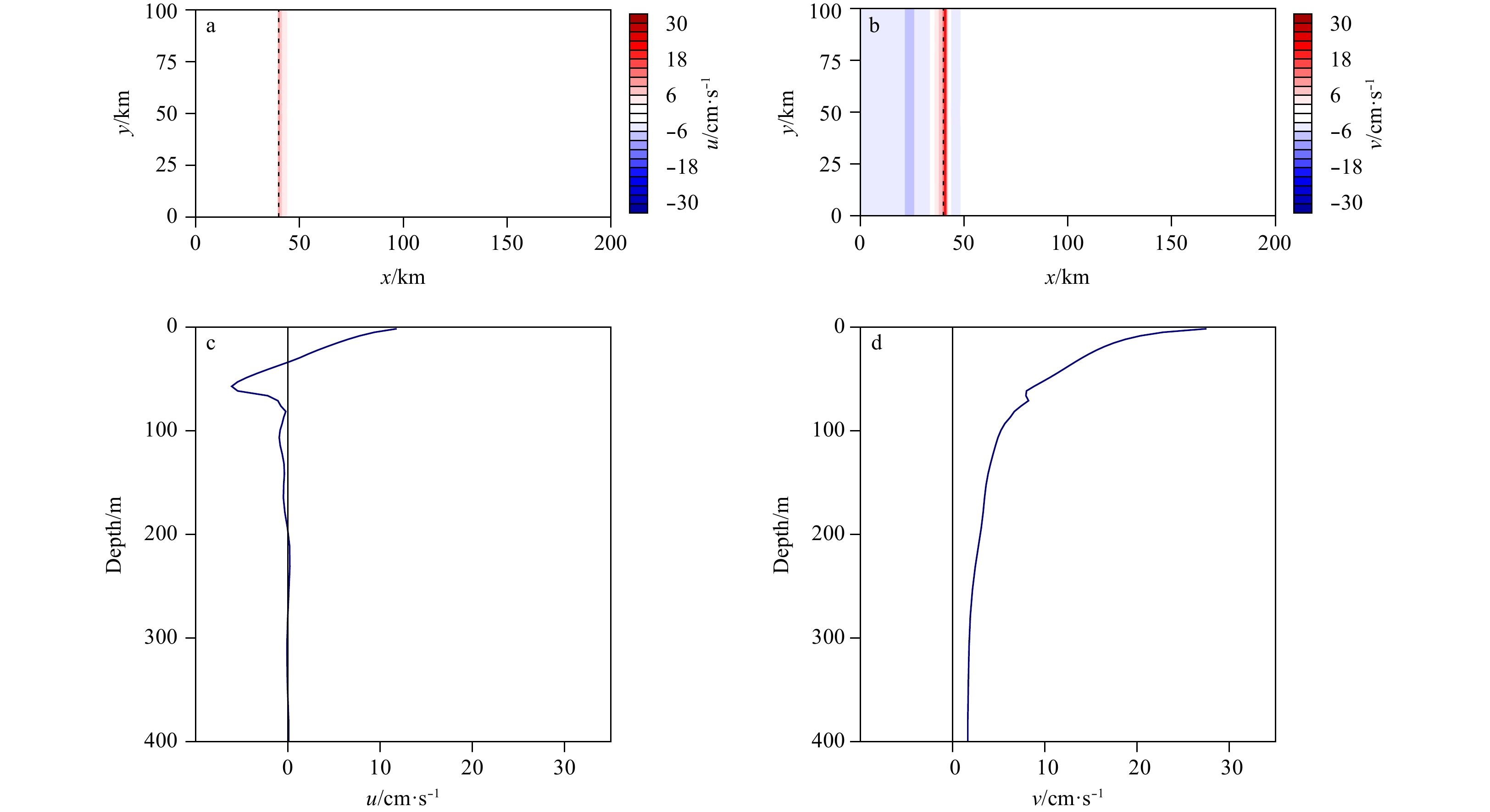
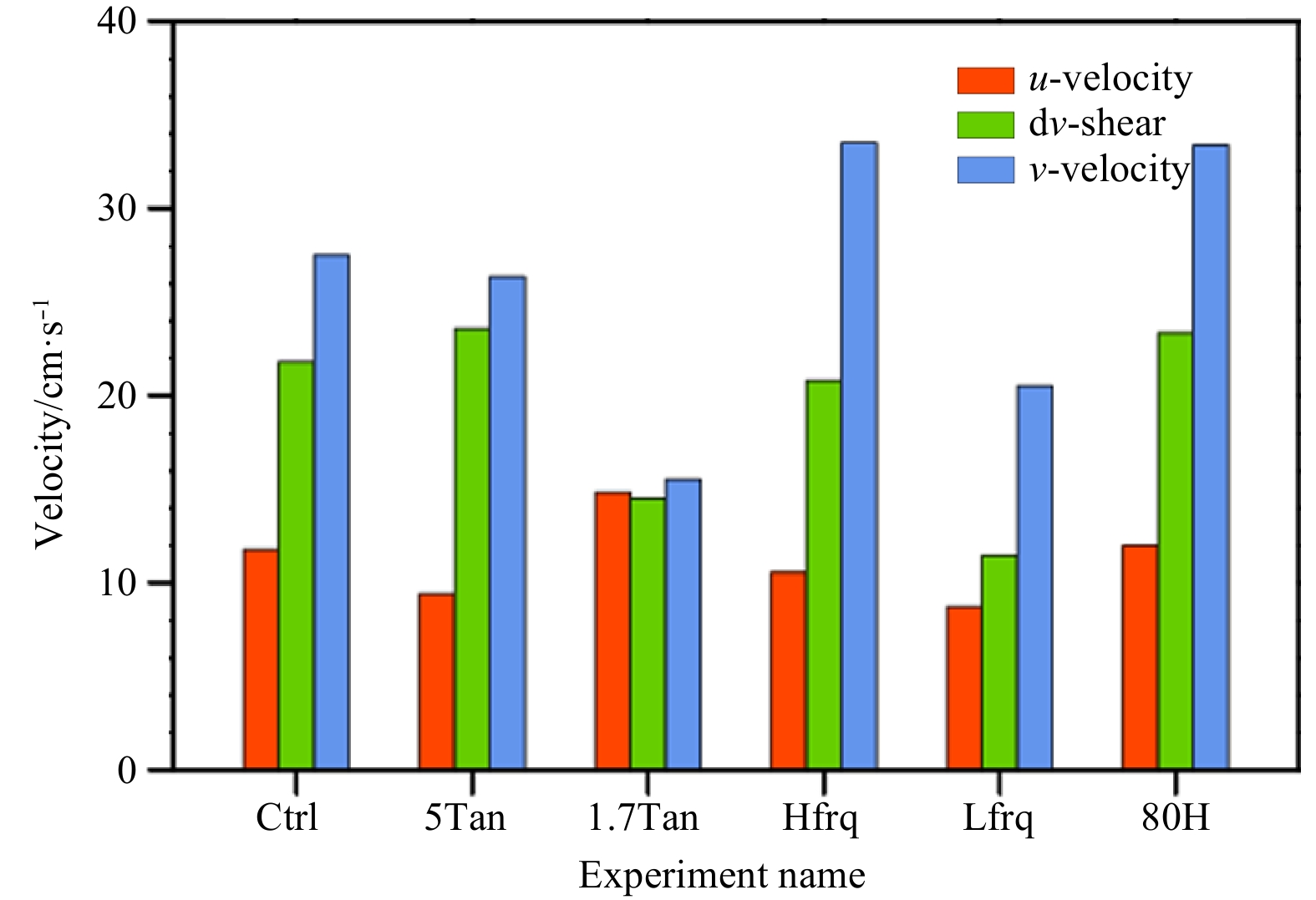
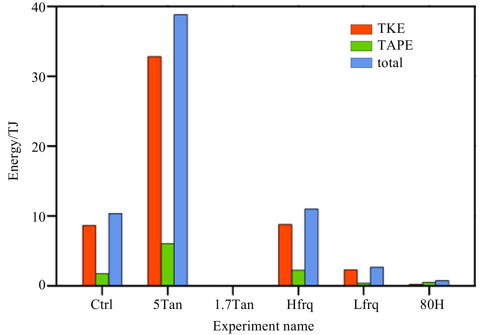
A coupled ocean-ice-wave model is used to study ice-edge jet and eddy genesis during surface gravity wave dissipation in a frazil-pancake ice zone. With observational data from the Beaufort Sea, possible wave dissipation processes are evaluated using sensitivity experiments. As wave energy dissipated, energy was transferred into ice floe through radiation stress. Later, energy was in turn transferred into current through ocean-ice interfacial stress. Since most of the wave energy is dissipated at the ice edge, ice-edge jets, which contained strong horizontal shear, appeared both in the ice zone and the ocean. Meanwhile, the wave propagation direction determines the velocity partition in the along-ice-edge and cross-ice-edge directions, which in turn determines the strength of the along-ice-edge jet and cross-ice-edge velocity. The momentum applied in the along-ice-edge (cross-ice-edge) direction increased (decreased) with larger incident angle, which is favorable condition for producing stronger mesoscale eddies, vice versa. The dissipation rate increases (decreases) with larger (smaller) wavenumber, which enhances (reduces) the jet strength and the strength of the mesoscale eddy. The strong along-ice-edge jet may extend to a deep layer (> 200 m). If the water depth is too shallow (e.g., 80 m), the jet may be largely dampened by bottom drag, and no visible mesoscale eddies are found. The results suggest that the bathymetry and incident wavenumber (magnitude and propagation direction) are important for wave-driven current and mesoscale eddy genesis.
A coupled ocean-ice-wave model is used to study ice-edge jet and eddy genesis during surface gravity wave dissipation in a frazil-pancake ice zone. With observational data from the Beaufort Sea, possible wave dissipation processes are evaluated using sensitivity experiments. As wave energy dissipated, energy was transferred into ice floe through radiation stress. Later, energy was in turn transferred into current through ocean-ice interfacial stress. Since most of the wave energy is dissipated at the ice edge, ice-edge jets, which contained strong horizontal shear, appeared both in the ice zone and the ocean. Meanwhile, the wave propagation direction determines the velocity partition in the along-ice-edge and cross-ice-edge directions, which in turn determines the strength of the along-ice-edge jet and cross-ice-edge velocity. The momentum applied in the along-ice-edge (cross-ice-edge) direction increased (decreased) with larger incident angle, which is favorable condition for producing stronger mesoscale eddies, vice versa. The dissipation rate increases (decreases) with larger (smaller) wavenumber, which enhances (reduces) the jet strength and the strength of the mesoscale eddy. The strong along-ice-edge jet may extend to a deep layer (> 200 m). If the water depth is too shallow (e.g., 80 m), the jet may be largely dampened by bottom drag, and no visible mesoscale eddies are found. The results suggest that the bathymetry and incident wavenumber (magnitude and propagation direction) are important for wave-driven current and mesoscale eddy genesis.


2020, 39(3): 130-140.
doi: 10.1007/s13131-020-1564-6
Abstract:
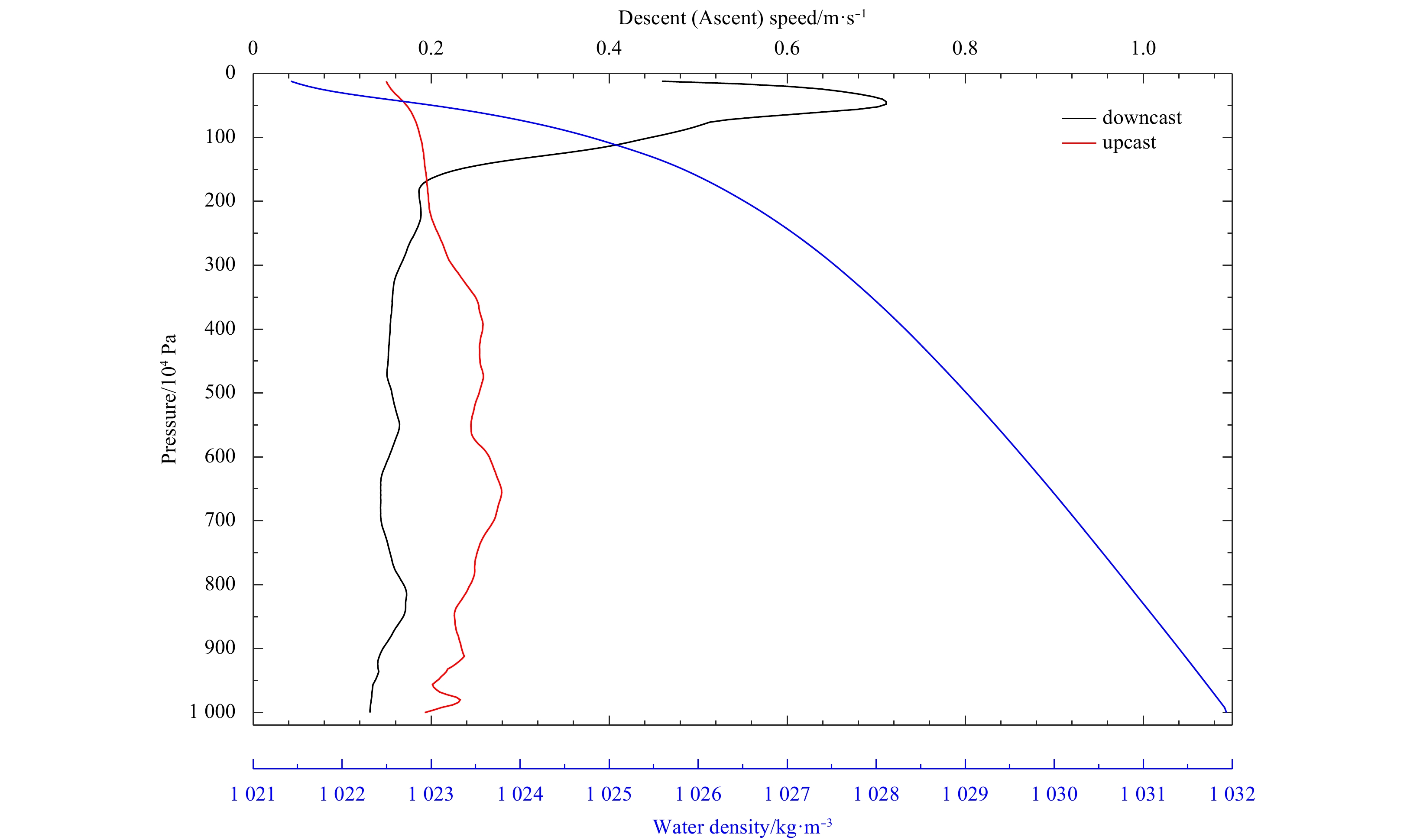
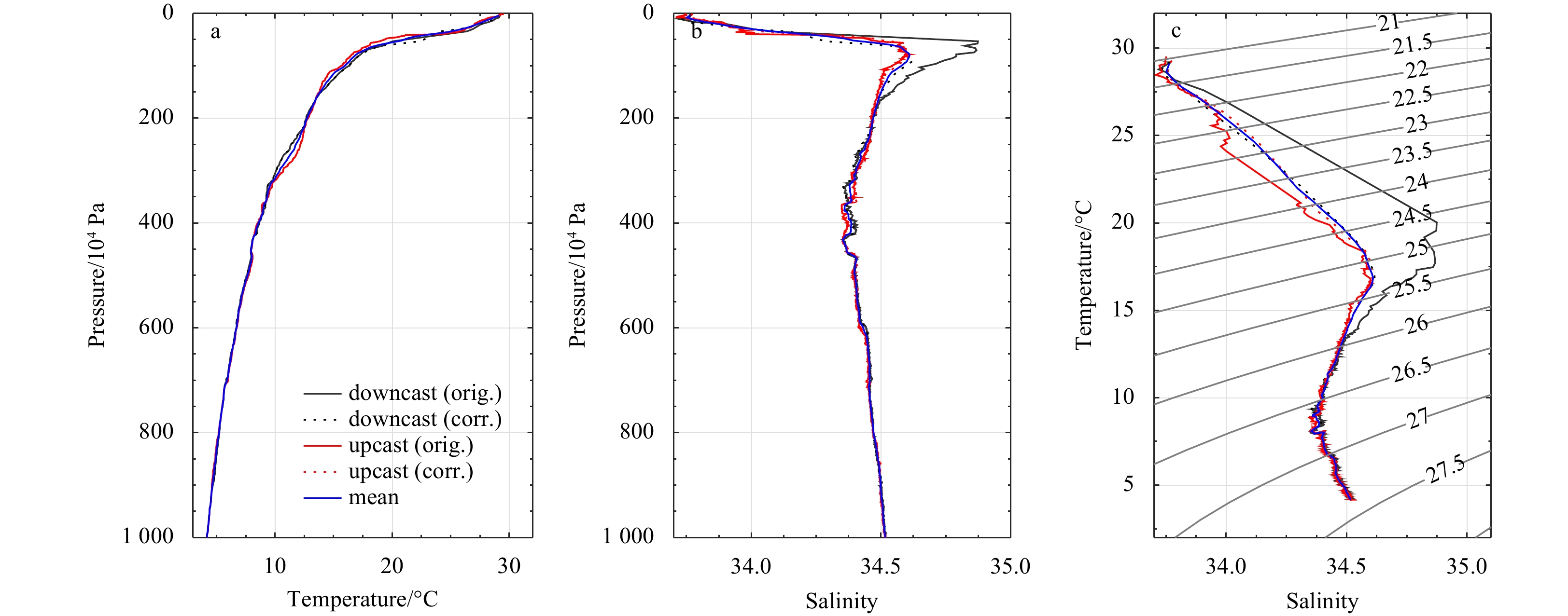
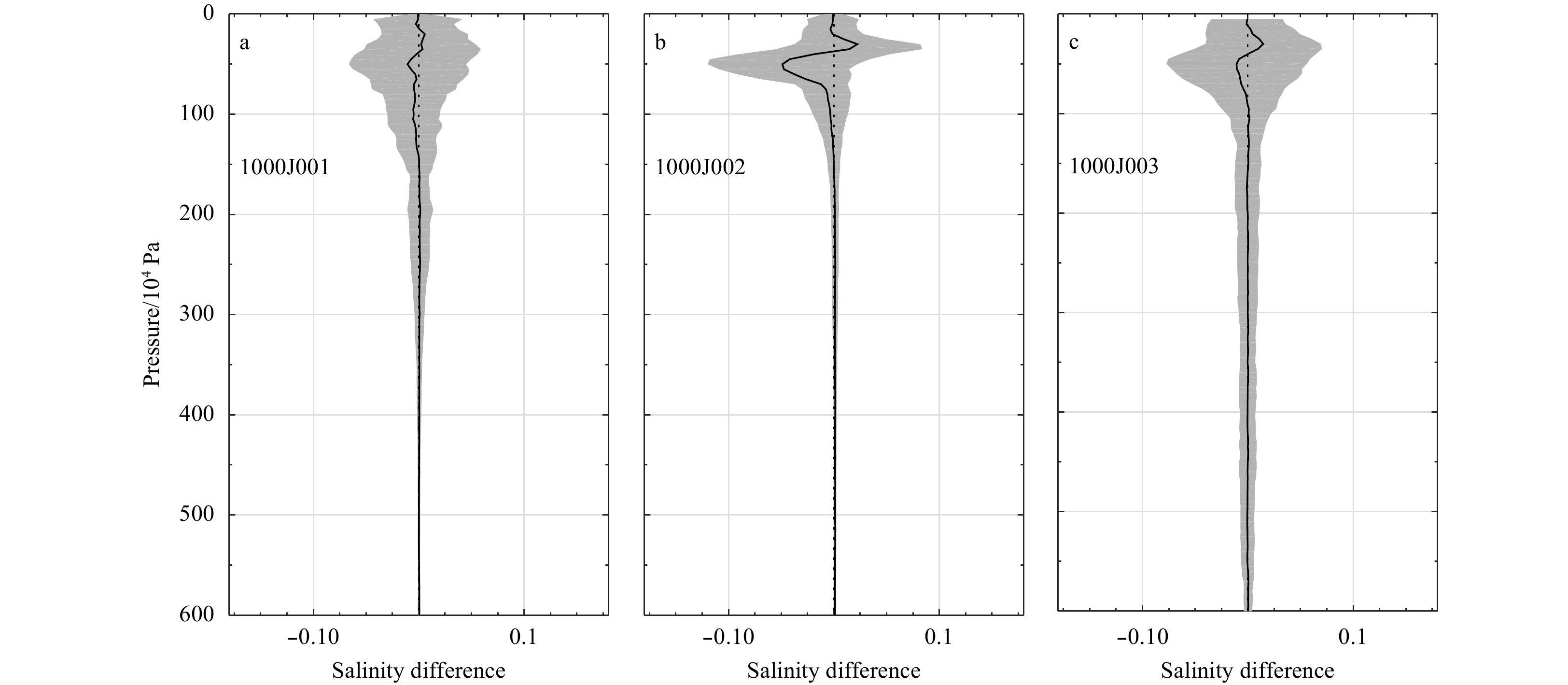
Profiles observed by Sea-Wing underwater gliders are widely applied in scientific research. However, the quality control (QC) of these data has received little attention. The mismatch between the temperature probe and conductivity cell response times generates erroneous salinities, especially across a strong thermocline. A sensor drift may occur owing to biofouling and biocide leakage into the conductivity cell when a glider has operated for several months. It is therefore critical to design a mature real-time QC procedure and develop a toolbox for the QC of Sea-Wing glider data. On the basis of temperature and salinity profiles observed by several Sea-Wing gliders each installed with a Sea-Bird Glider Payload CTD sensor, a real-time QC method including a thermal lag correction, Argo-equivalent real-time QC tests, and a simple post-processing procedure is proposed. The method can also be adopted for Petrel gliders.
Profiles observed by Sea-Wing underwater gliders are widely applied in scientific research. However, the quality control (QC) of these data has received little attention. The mismatch between the temperature probe and conductivity cell response times generates erroneous salinities, especially across a strong thermocline. A sensor drift may occur owing to biofouling and biocide leakage into the conductivity cell when a glider has operated for several months. It is therefore critical to design a mature real-time QC procedure and develop a toolbox for the QC of Sea-Wing glider data. On the basis of temperature and salinity profiles observed by several Sea-Wing gliders each installed with a Sea-Bird Glider Payload CTD sensor, a real-time QC method including a thermal lag correction, Argo-equivalent real-time QC tests, and a simple post-processing procedure is proposed. The method can also be adopted for Petrel gliders.


2020, 39(3): 141-147.
doi: 10.1007/s13131-020-1561-9
Abstract:
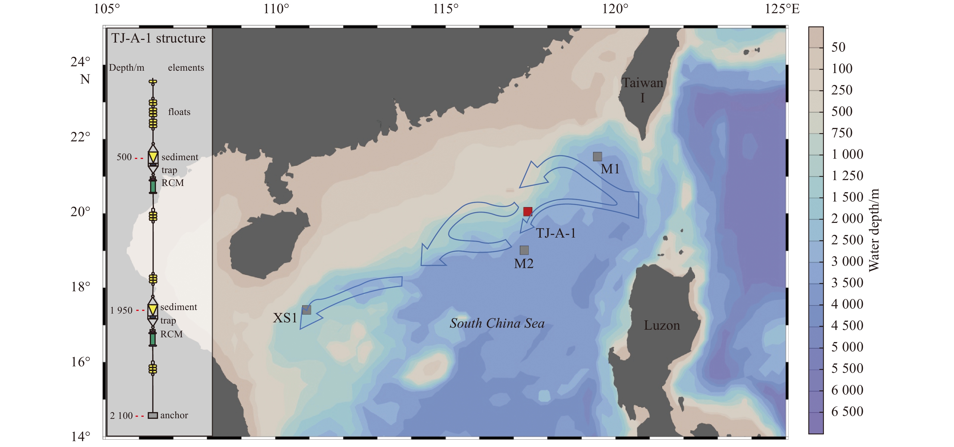
Sediment traps are an important tool for studying the source, composition and sedimentation processes of sinking particulate matter in the ocean. An in situ observational mooring (TJ-A-1) is located in the northern South China Sea (20.05°N, 117.42°E) at a water depth of 2 100 m and equipped with two sediment traps deployed at 500 m and 1 950 m. Samples were collected at 18-day intervals, and 20 samples were obtained at both depths from May 2014 to May 2015. Large amounts of fecal matter and marine snow were collected in the lower trap. The fluxes of marine snow and fecal pellets exhibited a fluctuating decrease between May 2014 and early August 2014 and then stabilized at a relatively low level. Scanning electron microscopy observations revealed that the main components of the marine snow and fecal pellets were diatoms, coccolithophores, radiolarians, and other debris, all of which are planktons mostly produced in photic zone. Used in conjunction with the particle collection range estimates from the lower trap and data on ocean surface chlorophyll, these marine snow and fecal pellets were related to the lateral transport of deep water and not vertical migrations from overlying water column. Moreover, the source area might be southwest of Taiwan.
Sediment traps are an important tool for studying the source, composition and sedimentation processes of sinking particulate matter in the ocean. An in situ observational mooring (TJ-A-1) is located in the northern South China Sea (20.05°N, 117.42°E) at a water depth of 2 100 m and equipped with two sediment traps deployed at 500 m and 1 950 m. Samples were collected at 18-day intervals, and 20 samples were obtained at both depths from May 2014 to May 2015. Large amounts of fecal matter and marine snow were collected in the lower trap. The fluxes of marine snow and fecal pellets exhibited a fluctuating decrease between May 2014 and early August 2014 and then stabilized at a relatively low level. Scanning electron microscopy observations revealed that the main components of the marine snow and fecal pellets were diatoms, coccolithophores, radiolarians, and other debris, all of which are planktons mostly produced in photic zone. Used in conjunction with the particle collection range estimates from the lower trap and data on ocean surface chlorophyll, these marine snow and fecal pellets were related to the lateral transport of deep water and not vertical migrations from overlying water column. Moreover, the source area might be southwest of Taiwan.


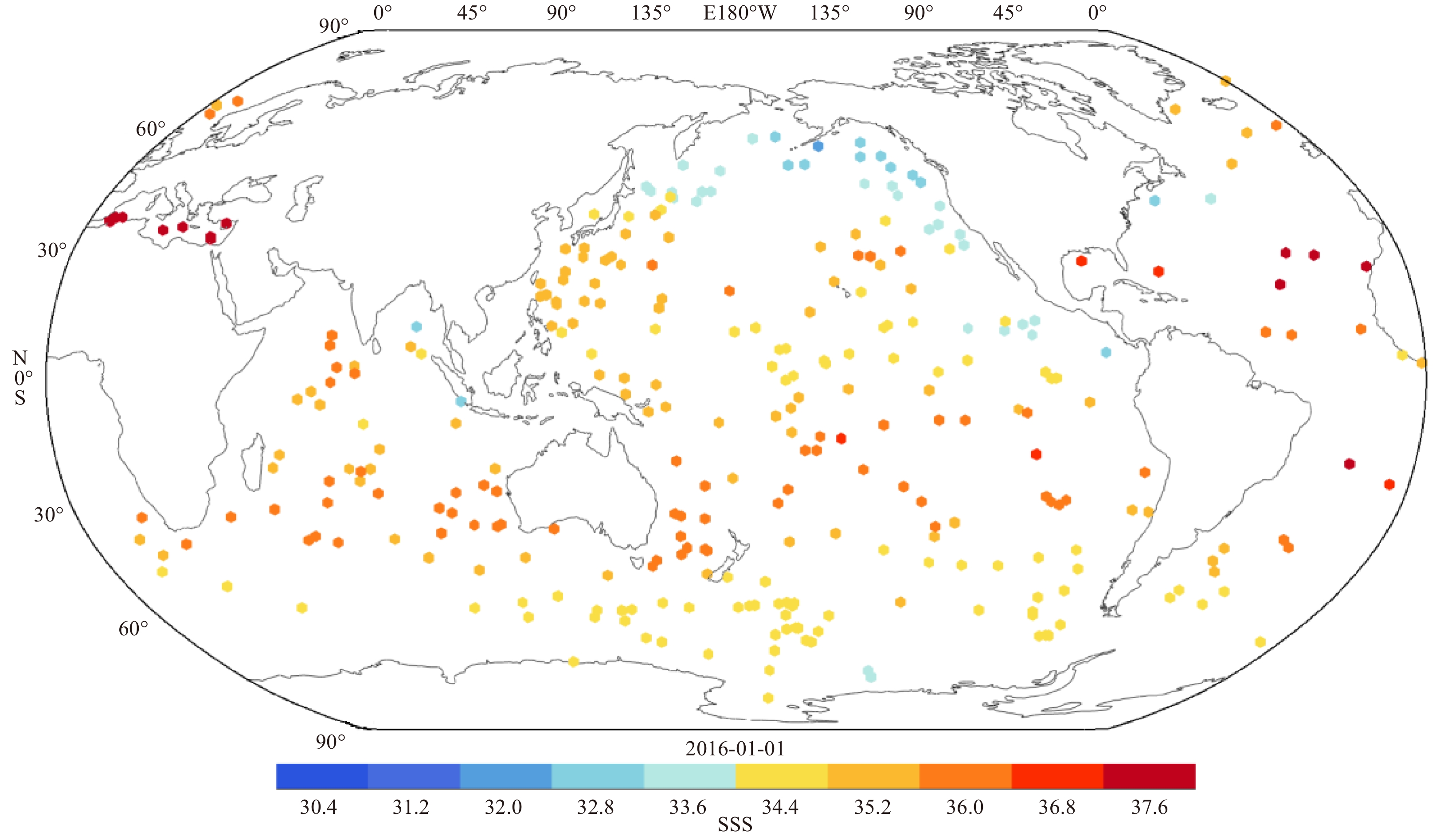
2020, 39(3): 148-158.
doi: 10.1007/s13131-020-1533-0
Abstract:
In this study, sea surface salinity (SSS) Level 3 (L3) daily product derived from soil moisture active passive (SMAP) during the year 2016, was validated and compared with SSS daily products derived from soil Moisture and ocean salinity (SMOS) and in-situ measurements. Generally, the root mean square error (RMSE) of the daily SSS products is larger along the coastal areas and at high latitudes and is smaller in the tropical regions and open oceans. Comparisons between the two types of daily satellite SSS product revealed that the RMSE was higher in the daily SMOS product than in the SMAP, whereas the bias of the daily SMOS was observed to be less than that of the SMAP when compared with Argo floats data. In addition, the latitude-dependent bias and RMSE of the SMAP SSS were found to be primarily influenced by the precipitation and the sea surface temperature (SST). Then, a regression analysis method which has adopted the precipitation and SST data was used to correct the larger bias of the daily SMAP product. It was confirmed that the corrected daily SMAP product could be used for assimilation in high-resolution forecast models, due to the fact that it was demonstrated to be unbiased and much closer to the in-situ measurements than the original uncorrected SMAP product.
In this study, sea surface salinity (SSS) Level 3 (L3) daily product derived from soil moisture active passive (SMAP) during the year 2016, was validated and compared with SSS daily products derived from soil Moisture and ocean salinity (SMOS) and in-situ measurements. Generally, the root mean square error (RMSE) of the daily SSS products is larger along the coastal areas and at high latitudes and is smaller in the tropical regions and open oceans. Comparisons between the two types of daily satellite SSS product revealed that the RMSE was higher in the daily SMOS product than in the SMAP, whereas the bias of the daily SMOS was observed to be less than that of the SMAP when compared with Argo floats data. In addition, the latitude-dependent bias and RMSE of the SMAP SSS were found to be primarily influenced by the precipitation and the sea surface temperature (SST). Then, a regression analysis method which has adopted the precipitation and SST data was used to correct the larger bias of the daily SMAP product. It was confirmed that the corrected daily SMAP product could be used for assimilation in high-resolution forecast models, due to the fact that it was demonstrated to be unbiased and much closer to the in-situ measurements than the original uncorrected SMAP product.